Embed Size (px)
Citation preview
S-1 TITLE 15
SUBDIVISION REGULATIONS
Chapters: 15.04 Subdivision Regulations 15.08 Final Plat accepted, Approved & Confirmed
CHAPTER 15.04
SUBDIVISION REGULATIONS
Sections: 15.04.01 General provisions and definitions 15.04.02 Administration and enforcement 15.04.03 Definitions 15.04.04 Review and approval process 15.04.05 Incidental subdivisions 15.04.06 Improvements and design standards 15.04.07 Utilities 15.04.01 General provisions and definitions
A. PURPOSE These Subdivision Regulations are intended to set forth the procedures, requirements and minimum standards governing the subdivision of land within the Planning Area of the city of Pea Ridge and shall be administered in the following manner:
1. To promote the public health, safety and general welfare of the citizens of
the city of Pea Ridge and outlying environs 2. To provide adequate air, open space, drainage, transportation, public
utilities and other needs 3. To assist in the orderly, efficient and coordinated development of land in
accordance to the adopted Comprehensive Plan and zoning Ordinance and Atlas
4. To ensure conformance of subdivision development with public improvement plans
5. To establish a beneficial relationship of the land and building uses with the municipal street system which will minimize traffic congestion and provide adequate pedestrian traffic circulation
178
S-15 6. To protect and conserve the value of buildings and improvements and to
minimize adverse impact on adjoining or nearby properties 7. To improve the aesthetics and welfare of the community by enforcing
reasonable design standards 8. To ensure proper legal descriptions and monumenting of subdivided lands 9. To encourage the wise use and management of natural resources and to
provide adequate and safe recreational areas of natural beauty and topography within the community
10. To ensure the development and maintenance of a healthy, attractive, and efficient community that provides for the conservation and protection of its natural and human resources.
B. AUTHORITY The regulations herein for the subdividing and developing of land
within the corporate limits and outlying area of Pea Ridge are adopted in accordance with the provisions of ACA 14-56-401 through 426.
C. JURISDICTION These regulations shall apply to all forms of subdividing as
defined herein and shall be applicable to all land within the city of Pea Ridge and to certain unincorporated areas in the county within one (1) mile of the corporate limits which is defined on the Planning Area Map. (Ord. No. 579, Sec. 1).
D. APPLICABILITY These regulations and development standards shall apply to
the following: 1. Subdivision A subdivision as defined in 15.04.03. 2. Previous division Any lot, tract or parcel of land resulting from or
created by the division of land within the city's jurisdiction as defined in subsection C on or after July 24, 1976, pursuant to or otherwise eligible for division under the provisions of Ord. No. 67 of the city.
a. Variance When application of these regulations pursuant to the
subsection D.2 causes undue hardship or inequitable imposition on the subdivider, the Planning Commission may consider a variance.
b. Procedure Written petition stating fully the grounds for the variance shall be made to the Planning commission which shall decide to grant or deny same. If granted the Planning Commission may proscribe any conditions or restrictions it deems necessary or appropriate in the public interest.
3. Property line adjustments A transfer of adjustment of a property line
which does not create a separate, new lot. 4. Large scale developments All large-scale developments except for
single family residences. 179
S-1
5. Dedications The dedication of any street, alley or other right-of-way through any land.
E. SEVERABILITY It is hereby declared to be the intention of the City Council
that the following provisions of these regulations be severable:
1. If any court of competent jurisdiction shall adjudge any provisions of these regulations to be invalid, such judgment shall not affect any other provision of these regulations to be invalid, such judgment shall not affect any other provision of these regulations that is not specifically included in such judgment.
2. If any court of competent jurisdiction shall adjudge invalid the application of any provision of these regulations to a particular subdivision of land, such judgment shall not affect the application of such provisions to any other subdivision of land that is not specifically included in such judgment.
F. INTERPRETATION In their interpretation and application, the provisions of
these regulations shall be held to be minimum requirements for the promotion of the public health, safety, and general welfare. Where the conditions imposed by any provisions of these regulations upon the subdivision of land are either more restrictive or less restrictive than comparable conditions imposed by any other applicable law, ordinance, resolution, rule or regulation of any kind, the regulations which are more restrictive and impose higher standards or requirements shall govern.
These regulations are not intended to abrogate any easement, covenant, or any other
private agreement, provided that where the regulations of this ordinance are more restrictive or impose higher standards or regulations than such easements, covenants, or other private agreement, the requirement of these regulations shall govern.
No subdivision of land which was not lawfully existing at the time of the adoption of
these regulations shall be made lawful solely by reason of the adoption of these regulations, and to the extent that such subdivision of land is in conflict in any manner with the requirements of these regulations, such subdivision of land remains unlawful hereunder.
G. AMENDMENT for the purpose of promoting the public health, safety and
general welfare, the Planning Commission may recommend amendments to these regulations, for which a public hearing shall be held, and a fifteen (15) day advance notification is published in a local newspaper of general circulation. Following such hearing, the City Council may adopt the amendment(s) as recommended by the Planning Commission. Provided, however, the City Council may, upon a majority vote of its entire membership, amend these regulations without the necessity of following the procedure prescribed in ACA 14-56-422. (Ord. No. 372, Sec. 1.)
180
S-3 15.04.02 Administration and enforcement A. ADMINISTRATION
1. Planning Department The Planning Department staff shall administer the rules and regulations herein.
2. Planning Commission The Planning Commission shall review and approve plats and make recommendations to the City Council concerning zoning and subdivision regulations and development proposals.
B. CONFORMANCE TO COMPREHENSIVE PLAN It is hereby declared to be the policy of the city of Pea Ridge to consider the subdivision of land and the subsequent development of subdivided plat as subject to the control of the city pursuant to the Comprehensive Plan, primarily the Land Use and Master Street Plan, for the orderly planned and efficient development of the city and its Planning Area. The various elements of the Comprehensive Plan, including the location of streets, parks, playgrounds, schools, and other public sites and appropriate land uses, shall be designed to conform with minimum zoning and building regulations for the area in which the proposed subdivision is located. C. APPROVALS REQUIRED No subdivider proposing to make or having made a subdivision within the Planning Area of the city of Pea Ridge shall proceed with any construction work, including grading, on the proposed subdivision before obtaining a Certificate of Preliminary Plat approval from the Planning Commission. Prior to obtaining from the Planning Commission a Certificate of Final Plat approval and prior to the acceptance and filing of said plat with the County Recorder, the subdivider shall not convey title to any lot, nor allow construction on any lot not necessary for obtaining final plat approval. (Ord. No. 417, Sec. 1.) D. CONCURRENT REGULATIONS AND AGENCIES In addition to the requirements established herein, all subdivision plats shall comply with all other applicable rules, regulations and laws including but not limited to the following:
1. City regulations and requirements Comprehensive Plan, Zoning Ordinance, building regulations and other pertinent city ordinance
2. Other agencies Benton County Health Department, Arkansas State Health Department and Arkansas State Highway and Transportation Department
E. INSPECTIONS
1. Notification The subdivider shall notify the city twenty-four (24) hours in advance of the placement of storm drainage pipe, subgrade preparation, curb and gutter construction, crushed stone base course and street pavement. No work shall proceed until approval has been given by the city.
181
S-2 2. Inspection criteria The appropriate city agency shall inspect for any
defects or deficiencies in installed improvements and the conformity of improvements to the final engineering plans and specifications accepted by the city.
3. Failed inspection If the inspection reveals defects and/or deficiencies, the appropriate city agency shall notify the subdivider and the subdivider's engineer in writing. The subdivider shall, at his/her expense, correct such defects and/or deficiencies prior to expiration of any bond or letter of credit.
4. Correction of defects and/or deficiencies When such defects and/or deficiencies have been corrected, the subdivider shall notify the city of Pea Ridge in writing that improvements are again ready, and a final inspection shall be conducted.
5. Completion of improvements When the improvements have been properly completed, the authorized agent of the subdivider shall submit a letter to the city certifying improvements and installations have been made in accordance with the approved construction plans, specifications, drawing, and standards established by the city and that such improvements are functioning properly. (Ord. No. 372, Sec. 2.)
6. Certified technician A certified technician for inspection shall be provided by the engineer. The certified technician for inspection shall submit weekly reports to the city on Monday, and it will address the work performed on all aspects of the improvements of the previous week. Minor subdivisions are exempt from this requirement. (Ord. No. 391, Sec. 1.)
7. Inspections Inspections must be completed five (5) days prior to a regularly scheduled Planning Commission meeting. If a re-inspection is required, a minimum of forty-eight (48) hours notice must be given to the inspector and a re-inspection fee of Two Hundred Fifty Dollars ($250.00) will be assessed upon the party requesting the inspection. This regulation applies to all final plat inspections. (Ord. No. 391, Sec. 2.)
8. Special meeting If a subdivider requests a special meeting of the Planning Commission or City Council, the subdivider shall bear all costs to the city associated with administering such a meeting. (Ord. No. 391, Sec. 3.)
F. VARIANCES When strict enforcement of the regulations herein causes an undue hardship on the subdivider, the Planning Commission may consider a variance. The Planning Commission may impose conditions to the variance to insure compliance and to protect adjacent property.
182
S-2 1. Consideration Under no circumstances shall a variance be granted
because of a personal or financial hardship. A variance must demonstrate the following:
a. Special conditions Special conditions and circumstances are
peculiar to the land involved and are not applicable to other lands. b. Deprivation of rights The literal interpretation of the regulations
would deprive the applicant of rights commonly enjoyed by other properties within the same area.
c. Resulting actions The special conditions and circumstances do not result from the actions of the applicant.
d. Special privileges Granting the variance will not confer on the applicant any special privilege(s) that is denied by these regulations.
e. Non-conforming uses No non-conforming use of neighboring lands in the same or within another district shall be considered grounds for the issuance of a variance.
182.1

S-3 f. Public health, safety and welfare Granting the variance request
will not cause a detriment to the public health, safety and welfare or be injurious to other property in the area.
2. Procedure No variance shall be granted except upon written petition by
the subdivider when the preliminary plat is filed. Under exceptional circumstances the Planning Commission may grant variances at the time of final plat approval. The petition shall state fully the grounds for the variance and all the facts upon which the petition is made. In granting the variance, the Commission shall prescribe any conditions that it deems necessary to or desirable in the public interest.
G. ENFORCEMENT It shall be the duty of the city's departmental inspectors, to enforce these regulations within the Planning Area. When directed, the City Attorney shall initiate appropriate legal action to enforce the provisions of this ordinance and/or the standards referred to herein. In order to carry out the purposes of these regulations and to assure the orderly development of land after the effective date of these regulations, the following shall apply:
1. Building permits No building permit will be issued by the Building Inspection Office for any structure on any lot in a subdivision that has not received final plat approval from the Planning Commission and the City Council or that is in violation of the provisions of this ordinance or the standards referred to herein unless a parcel of property was established by deed prior to July 24, 1976. (Ord. No. 417, Sec. 2.)
2. Utilities No permanent utilities will be activated until the city accepts the improvements, or until a performance bond or letter of credit has been tendered and accepted by the Planning Commission.
3. Recording No plat of any subdivision shall be accepted by the County Recorder for filing of record until it is approved by the Planning Commission and accepted by the City Council. Until the plat is recorded, no utility (public or private) shall provide, extend or authorize the extension of permanent service to any lot, building or structure.
4. Conveyance No conveyance by metes and bounds of tracts or lots included within the definition of subdivision shall be made without compliance with the applicable provisions of this ordinance.
H. PENALTY Any person who shall violate any of the provision of this ordinance, or who shall fail to comply with any provisions hereof shall be guilty of a misdemeanor, and upon conviction shall be subject to a fine not to exceed Two Hundred Fifty Dollars ($250.00). Each day that such violation continues shall constitute a separate offense and shall be punishable accordingly.
183
S-1
The owner or tenant of any building, structure, premises, or part thereof, and any architect, builder, engineer, agent, or other person, who commits, participates in or maintains such violation may be found guilty of a separate offense and suffer the penalties herein provided. (Ord. No. 372, Sec. 2.) 15.04.03 Definitions Definitions not specified in this article are to be interpreted based on customary usage in municipal planning and engineering practices. Access A way or means that provides vehicular and/or pedestrian ingress to and/or egress from a property. Alley A minor, permanent public access used primarily for vehicular access to the back or the side of properties abutting a street. Arterial street See "Street classification" Authorized agent An architect, attorney, building, subdivider or other person(s) legally empowered to act on behalf of other persons. Berm An earthen mound designed to provide visual interest, screen undesirable views, and/or decrease noise. Bill of assurance A document containing the limitations and restrictions placed upon a subdivision by the subdivider. Block An area of land surrounded by public highways, streets, streams, railroad right-of-ways, parks or similar facilities. Bond Any form of security including a cash deposit, surety bond, collateral, property, or instrument of credit in an amount and form satisfactory to the city. Building Any structure used or intended for supporting or sheltering any use or occupancy. Building line A line parallel to the lot line, imaginary or otherwise, that indicates the setback. Within the setback area, no part of the principal building may be constructed except uncovered porches, stoops and steps. Buffer A continuous are of land set aside along the perimeter of a lot, parcel or tract in which landscaping is used to provide a transition between spaces and to reduce the environmental and aesthetic impact that one type of land use may impose on another. City The city of Pea Ridge, Benton County, Arkansas.
184
S-1 City Attorney, City Clerk, City Engineer, City Building Official, City Planning Commission, Mayor A professional retained by the city, an official elected or appointed to a position or a duly authorized representative of an official. Collector street See "Street classification." Comprehensive Plan A composite of the mapped and written proposals recommending the physical development of the community which shall have been adopted by the Planning Commission and City Council. Contour intervals Topographic map lines that represent elevation of land. Corner lot A platted lot with at least two adjacent sides abutting intersecting streets. Covenant A private agreement between the buyer and seller that asserts legal requirements on the use of the land. Covenants are typically contained in the property deed or otherwise formally recorded. Enforcement is by legal action initiated by private individuals not by the city. County Recorder The County Recorder of Benton County, Arkansas. Cul-de-sac A local street having one end open to traffic and being permanently terminated by a vehicular turnaround. Dead-end street A street having one end open to traffic and is permanently terminated at the opposite end. Dedication Land and improvements offered to and accepted by the city for public use, control, and maintenance. Deed A legal document conveying ownership of real property. Developer A person, firm or corporation undertaking the development on a subdivision of land. Development Any man-made change in improved and unimproved real estate including but not limited to buildings or other structures, drilling, dredging, filling, grading, paving, excavation or storage of equipment or materials. Double frontage lot A lot abutting two non-intersecting streets. Drainage-way An approved means, natural or man-made, or removing or providing for the removal of surface water.
185
S-1 Dwelling unit A building or portion thereof designed for residential occupancy. Easement The right of a person, government agency, or public utility company to use public or private land owned by another for a specific purpose. Engineer A person duly authorized under the provisions of the Arkansas Engineering Registration Act to practice the profession of engineering in the state of Arkansas. Federal Emergency Management Agency (FEMA) The independent federal agency that, in addition to carrying out other activities, oversees the administration of the National Flood Insurance Program. Final plat The final application proposal submitted by a subdivider to the Planning Commission. The final plat should include all recommended changes to the preliminary plat. Signed approval of the final plat by the City Council, along with certification of title and filing of the plat, means the legal creation of a subdivision. Flood A general and temporary condition of partial or complete inundation of normally dry land caused from the overflow of inland or tidal water or the unusual and rapid accumulation of runoff or surface waters. Floodplain A geographical area susceptible to periodic inundation from overflow of natural waterways and determined as to extent by the Federal Emergency Management Agency (FEMA). Floodway The channel of a river or other water course and the adjacent land areas that must be reserved in order to discharge the base flood without cumulatively increasing the surface water elevation more than a designated height. Frontage the edge of a lot bordering a street. Frontage street/road See "Street, frontage." Grading the act of moving ground or soil to adjust elevation or slope. Improvement plans The engineering drawings showing types of materials and construction details for the physical structures and facilities, excluding dwelling units, to be installed in conjunction with the development of a subdivision. Improvements Facilities which aid in land development. Improvements include streets; sewer, water mains and storm drains; curbs, gutters and sidewalks; street lights, fire hydrants and other required amenities.
186
S-1
Incidental subdivision the division of land in which the review process is expedited. Incidental subdivisions include lot splits and minor subdivisions (Refer to 14.04.05)
Inspection Examination of work, completed or in-progress that evaluates the integrity of
the work and its compliance with code and/or contract requirements. Land surveyor A person who is registered in the state of Arkansas to make land
surveys. Lot A piece of land divided from a larger tract. Lot, corner See "Corner lot." Lot split A division of land creating only one new lot. Minor subdivision A division of land into four (4) or fewer lots and which does not
require dedications, vacations, reservations, changes in alignment of easements of right-of-ways or extensions of utilities (Refer to 14.04.05.)
Off-site improvement Any part of a street, surface drainage system, water system, or
sanitary sewer system, which is to be installed on property located outside the proposed development. (Refer to 14.04.06 (K).)
Parcel A piece of land or group of lots under a single ownership or control. A parcel is
usually viewed as a single unit for development purposes. Paving width The portion of a street available for vehicular traffic and is the distance
from back of curb to back of curb. Planned Unit Development (PUD) A zoning development management approach to
physical growth which combines housing, commercial, light manufacturing, and open space uses all in the same zone while maintaining an overall density comparable to conventional development.
Planning Area The area within the city's territorial jurisdiction for which the Planning
Commission has determined it will prepare plans and recommended ordinances and regulations. The Planning Area shall be the area in which provisions of the Pea Ridge Subdivision Regulations shall apply.
Planning Commission The Planning Commission of the city of Pea Ridge, Arkansas. Plat A drawing of a subdivision, showing the number and dimensions of lots, public
rights-of-way, easements and other improvements. 187
S-1 Preliminary plat The formal application proposal submitted by a subdivider to the
Planning Commission. The preliminary plat shows the subdivided property, lots, street and easements.
Private street See "Street, private." Property line adjustment An adjustment of a property line which does not create a
separate, new lot. A property line adjustment may or may not dedicate right-of-way or utility easements.
Right-of-way An area of land reserved or dedicated for a street, walk drainage or other
public purposes. Setback The required minimum horizontal distance between the building line and the
related front, side, or rear property line. Shall A mandatory directive. Sketch Plan A pre-application proposal submitted by a subdivider to the Planning
Department staff. The Planning Department will provide information to the subdivider concerning policies and regulations, offer advice to the subdivider in order to avoid unnecessary costs and delays and preempt any potential conflicts and problems.
Split, lot See "Lot split." Street A trip of land, including the entire right-of-way, intended primarily as a means of
vehicular and pedestrian travel which may also be used to provide space for sewers, public utilities, trees and sidewalks.
Street classification
Arterial A street or road of considerable continuity which serves or is intended to serve as a principal traffic-way between separate areas, districts, communities or densely developed areas and I the main means of access to the primary street system or expressway. Boundary A street that abuts a property. Collector A street which, in addition to serving abutting properties, intercepts minor streets connects with community facilities and carries neighborhood traffic to major arterial street systems. Local Minor streets used primarily to provide access within a property and to an abutting property.
188
S-15 Street, frontage A street that provides access between a major roadway and a lot, parcel
or tract. Street, private A right-of-way or easement in private ownership not dedicated or
maintained as a public street. Subdivider A person, firm, corporation or any agent thereof dividing or proposing to
divide land so as to constitute a subdivision. The term subdivider includes the subdivider, owner and authorized agent. The subdivider is occasionally referred to herein as the applicant.
Subdivision The division of land into four (4) or more lots for the purpose of sale, lease
or development. (Ord. No. 391, Sec. 4.) Territorial jurisdiction all land within the city of Pea Ridge and certain unincorporated
areas in the county within one (1) mile of the corporate limits. The territorial jurisdiction shall be the area in which provisions of the Pea Ridge Subdivision Regulations shall apply. (Ord. No. 579, Sec. 2).
Tract Land under single ownership or control. A tract usually covers a substantial
acreage and has the potential to be subdivided into lots. Use A purpose to which land is committed. Variance an exception from the strict application of the provisions of this ordinance. (Ord. No. 372, Sec. 3.) 15.04.04 Review and approval process Subdividers must follow the subdivision review
process when subdividing land within the Planning Area of the city of Pea Ridge. The sequential steps of the review process are the pre-application conference, preliminary plat review and final plat review.
A. PRE-APPLICATION CONFERENCE The subdivider is strongly encouraged
to meet informally with the Planning Department by scheduling a pre-application conference. No fee is collected for this service.
1. Purpose The purpose of the pre-application conference is to provide
information to the subdivider concerning policies and regulations, to offer advice to the subdivider in order to avoid unnecessary costs and delays and to preempt any potential conflicts and problems. Items discussed at the conference include but are not limited to the following: general character of the proposed development, zoning, utility service, street requirements, flooding and drainage.
2. Sketch Plan The subdivider may present a sketch plan at the pre-application conference, which includes the following:
189
S-19 a. Minimum scale of 1" = 200'
b. Location of the subdivision c. Existing conditions on the site and within a few hundred feet of the
subdivision: streets, utilities, building, physical features d. Existing restrictions: easements, zoning lines, covenants e. Proposed layout of the subdivision: lots, streets, utilities, systems
of drainage, sewerage, and water supply f. Name of the subdivision owner and all adjoining property owners.
B. PRELIMINARY PLAT The subdivider must obtain preliminary plat approval
from the Planning Commission and improvement plan approval from the city before proceeding with any grading and construction work. The process for the preliminary plat includes the submission of an application package by the applicant and review by the Planning Commission. (Ord. No. 661, Section 1). l. Submission requirements. The subdivider or authorized agent shall submit
an application package to the Planning Department containing the following: a. Application b. Letter of transmittal c. Six (6) copies of the plat on 24 x 36 paper, six (6) copies of the
plat on 11 x 17 paper, one electronic copy in Adobe Portable Document Format (PDF) emailed to the city (Refer to subsection E for information required on plat), and one electronic copy in CAD file format, georeferenced, emailed to Pea Ridge Water Utilities.
d. One (1) copy of required documents (Refer to subsection E for list of documents)
e. Fee (Refer to subsection D)(Ord. No. 375, Sec. 1; Ord. No. 632, Sec. 1; Ord. No. 661, Section 1)
2. Improvement plans a. Submission At the time or subsequent to submission of the
preliminary plat package, the subdivider or authorized agent shall submit to the Planning Department the following:
(1) Letter of transmittal (2) Three (3) copies of plans (Refer to subsection E for
information required on plans) (3) One (1) copy of required documents (Refer to subsection E
for list of documents). b. Health Department approval The subdivider or engineer shall
submit water and sewer plans to the County and/or State Health Department for approval regardless of whether public or private systems are used. No water, sewer and/or utility work shall start until approval has been granted by the Health Department.
190
S-1 c. Changes after Preliminary Plat approval Changes shall require
Planning Commission approval prior to the start of construction in the effected area.
3. Review After the Planning Commission has reviewed the Preliminary
Plat and has considered staff recommendations during the Planning Commission meeting, the Commission has ninety (90) days from date of receipt of application package to approve, disapprove or approve conditionally. If no decision is made within the ninety (90) days, the Preliminary Plat is deemed approved unless the applicant stipulates in writing to the Planning Commission that additional time is acceptable.
4. Disapproval Within two (2) weeks after the Planning Commission's decision, the Planning Department shall send the applicant a written statement of the reasons for disapproval.
5. Approval Within two (2) weeks after the Planning Commission's decision, the applicant shall receive a signed copy of the Preliminary Plat and improvement plans. The Planning Commission's approval of the Preliminary Plat is deemed as an authorization to proceed with the preparation of the final plat, the installation of improvements and the staking out of lots and blocks. Approval of a Preliminary Plat shall not consequentially guarantee approval of the Final Plat.
6. Conditional approval Within two (2) weeks after the Planning Commission's decision, the Planning Department shall send the applicant a signed copy of the Preliminary Plat and improvement plans along with a written statement of any required changes and/or additions.
7. Expiration To officially approve the Preliminary Plat, the Chairman of the Planning Commission shall sign the Certificate of Preliminary Plat approval that is included on the plat. The Certificate shall expire twelve (12) months from date of approval unless an extension is granted by the Planning Commission. If the Preliminary Plat expires, further development work shall require approval of another Preliminary Plat.
8. Extension Before the last day of the twelve (12) months from date of approval, the applicant may request in writing an extension of Preliminary Plat approval. The Planning Commission may grant an extension up to twelve (12) months providing, in the opinion of the Planning Commission, that sufficient work is complete with regard to the required improvements on the property. No more than one extension shall be granted. The Planning Commission may waive the fee for an extension if the extension is not a result of the applicant's actions.
C. FINAL PLAT When the requirements of Subsection B have been satisfied and the Preliminary Plat approval remains valid, the subdivider or authorized agent may submit to
191
S-19 the Planning Department a Final Plat application package for review and approval by the Planning Commission.
1. Submission requirements Before the preliminary plat expires and at least fifteen (15) days prior to the regularly scheduled Planning Commission meeting, the subdivider or authorized agent shall submit an application package to the Planning Department containing the following:
a. Application
b. Letter of transmittal c. Six (6) copies of the plat on 24 x 36 paper, six (6) copies of the
Final Plat on 11 x 17 paper, and one electronic copy in Adobe Portable Document Format (PDF) emailed to the city (Refer to subsection E for information required on plat)
d. One (1) of as built drawings submitted to the city by email via Adobe Portable Document Format (PDF) , one copy of as built drawings submitted to the city on hard disc, and one electronic copy of as built in CAD file format, georeferended, emailed to Pea Ridge Water Utilities.
e. Fee (Refer to subsection D) (Ord. No. 632, Sec. 2; Ord. No. 661, Sec. 3.)
2. Review The Planning Commission has ninety (90) days from date of
receipt of application package to approve, disapprove or approve conditionally; otherwise, the Final Plat shall be deemed approved. If the applicant wants to develop only a portion of the property for which the Preliminary Plat was approved, he/she must submit a written request to the Planning Department, and the Planning Commission may grant approval of a final plat for said portion alone during a regularly scheduled meeting.
3. Disapproval Within two (2) weeks after the Planning Commission's
decision, the Planning Department shall send a written statement of the reasons for disapproval.
4. Approval Within two (2) weeks after the Planning Commission's
decision, the applicant shall receive a signed copy of the Final Plat. approval of the Final Plat will not constitute the acceptance by the public of any dedication of public improvements and lands.
5. Guarantee of completion Before the Final Plat is recorded with the
County Recorder, the City Council must officially accept all dedications of utilities, public improvements and lands for public use along with other
192
S-19
agreements and requirements that the Planning Commission contingently applied to the Final Plat approval. The City Council must receive one of the following prior to accepting any public dedication:
a. Certificate of completion The subdivider shall submit to the City
Council a certificate stating that all required improvements and installations to the subdivision are completed; or
b. Cash deposit in the full amount The project engineer and the Planning Commission, with legal assistance, shall agree on an amount required to complete the improvements and installations in compliance with city codes. The agreed amount will be subject to a multiplier of 1.5 in order to calculate the cash deposit required from the subdivider. Along with the cash deposit, a written statement shall be submitted specifying the necessary time to complete all improvements and installations. The cash deposit may be withdrawn in direct proportion to the amount of work completed; or
c. Performance bond The performance bond must be payable to the city and must meet the City Attorney’s approval as to form, sufficiency and manner of execution. The amount of the bond will be based on an agreement between the project engineer and the Planning Commission, with legal assistance, as to the necessary funds required to complete the improvements and installations in compliance with city codes. The agreed amount will be subject to a multiplier of 1.5. the bond must be secured by collateral that is acceptable to the city. The bond shall specify the necessary time to complete all improvements and installations, not exceed two (2) years from date of final plat approval and shall be indicated in the motion for approving the Final Plat and in the bond. If improvements are not complete within the allocated time, the city will collect the specified amount and complete the improvements. (Ord. No. 579, Sec. 3).
6. Recording Within two weeks after City Council's approval of the Final
Plat and acceptance of the public dedications, the subdivider or authorized agent shall record the Final Plat with the County Recorder. The subdivider or authorized agent shall send one (1) copy to the Tax Assessor and shall send two (2) filed copies of the final Plat on 18 x 24 paper to the Planning Department. (Ord. No. 632, Sec. 2.)
7.
a. Maintenance bond for streets improvements Before the final plat is recorded with the Benton County Clerk and Recorder’s
193
S-19 office, the city must receive a bond guaranteeing the work performed upon all street improvements, including, but not limited to the street base, the pavement, the curb and gutter, and the street lights. The amount of the bond will be equal to, or greater than fifty percent (50%) of the total cost of all street improvements and will be for a period of eighteen (18) months. The cost of these improvements will be certified to the city by the developer’s engineer. The bond must be payable to the city of Pea Ridge and
must meet the City Attorney’s approval as to form, sufficiency and manner of execution. The bond must be secured by collateral that is acceptable to the city. Should a warranty or maintenance issue with the street improvements arise, the city may present the developer with the opportunity to make the necessary repairs to the improvements. However, at all times, the city retains the right to collect the specified amount from the bond and perform the necessary repairs itself. (Ord. No. 579, Sec. 4).
b. Maintenance bond for water and sewer improvements Before
the final plat is recorded with the Benton County Clerk and Recorder’s office, the city must receive a bond guaranteeing the work performed upon all water and sewer improvements. The amount of the bond will be equal to, or greater than, fifty percent (50%) of the total cost of all water and sewer improvements and will be for a period of twelve (12) months. The cost of these improvements will be certified to the city by the developer’s engineer. The bond must be payable to the city of Pea Ridge and must meet the City Attorney’s approval as to form, sufficiency, and manner of execution. The bond must be secured by collateral that is acceptable to the city. Should a warranty or maintenance issue with the water and sewer improvements arise, the city may present the developer with the opportunity to make the necessary repairs to the improvements. However, at all times, the city retains the right to collect the specified amount from the bond and perform the necessary repairs itself. (Ord. No. 579, Sec. 4).
c. Walk-through inspection and bond release Thirty (30) days
prior to the expiration of term of the maintenance bonds, described in subparagraphs a and b of this subsection, the City Inspector shall conduct a walk-through inspection of all street, water and sewer improvements. Should maintenance issues be discovered during this walkthrough inspection, the developer shall be notified and given the opportunity to correct those issues. At all times the city retains the right to collect the specified amount from the bond and
193.1
S-19
perform the necessary repairs itself. No bond or security shall be released by the city until a successful walk-through inspection has been completed. Upon satisfactory completion of the walk-through inspection by the City Inspector and after the specified bond term has expired the bond shall be voided, and any unused amount from the bond shall be refunded to the developer. (Ord. No. 579, Sec. 4).
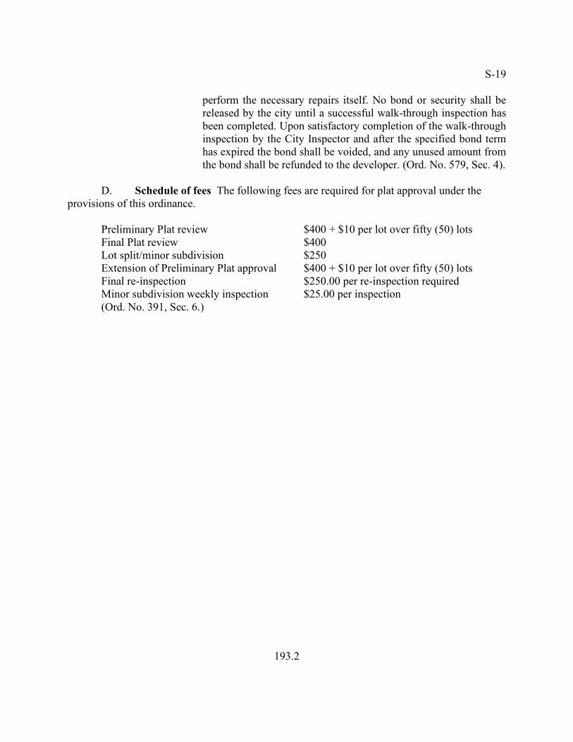
D. Schedule of fees The following fees are required for plat approval under the
provisions of this ordinance. Preliminary Plat review $400 + $10 per lot over fifty (50) lots Final Plat review $400 Lot split/minor subdivision $250 Extension of Preliminary Plat approval $400 + $10 per lot over fifty (50) lots Final re-inspection $250.00 per re-inspection required Minor subdivision weekly inspection $25.00 per inspection (Ord. No. 391, Sec. 6.)
193.2
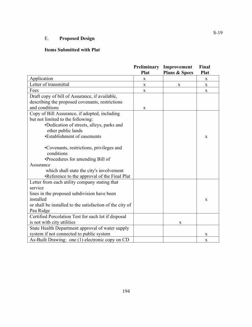
S-19 E. Proposed Design Items Submitted with Plat Preliminary Improvement Final Plat Plans & Specs Plat
Application x x Letter of transmittal x x x Fees x x Draft copy of bill of Assurance, if available, describing the proposed covenants, restrictions and conditions
x
Copy of Bill Assurance, if adopted, including but not limited to the following:
•Dedication of streets, alleys, parks and other public lands
•Establishment of easements
•Covenants, restrictions, privileges and conditions •Procedures for amending Bill of
Assurance which shall state the city's involvement •Reference to the approval of the Final Plat
x
Letter from each utility company stating that service lines in the proposed subdivision have been installed or shall be installed to the satisfaction of the city of Pea Ridge
x
Certified Percolation Test for each lot if disposal is not with city utilities
x
State Health Department approval of water supply system if not connected to public system
x
As-Built Drawing: one (1) electronic copy on CD x
194

S-1
Items Included on Plats Applicant Information Preliminary Improvement Final Plat Plans & Specs Plat
Name of subdivision x x x Name and address of owner of record x x x Name and address of subdivider x x x Name and address of surveyor or engineer x x x
General Items
Quality: neat and legible; No patching pasting or other modifications and attachments
x
x
x
Good quality, acid free paper or Mylar x Margins: top, bottom and right: ½ "; left: 1 ½ " x North arrow x x x Graphic scale: no smaller than 1" = 100' x x Date of document x x Key map required when more than one sheet is used for a plat. The entire subdivision shall be shown at a smaller scale on the first sheet.
x
x
Vicinity map showing location and acreage of subdivision
x
x
Current zoning classification of the proposed subdivision and the adjacent land
x
x
Existing items
Existing streets, buildings, easement, utilities, culverts, and other permanent items on and adjacent to the tract.
x
x
x
195
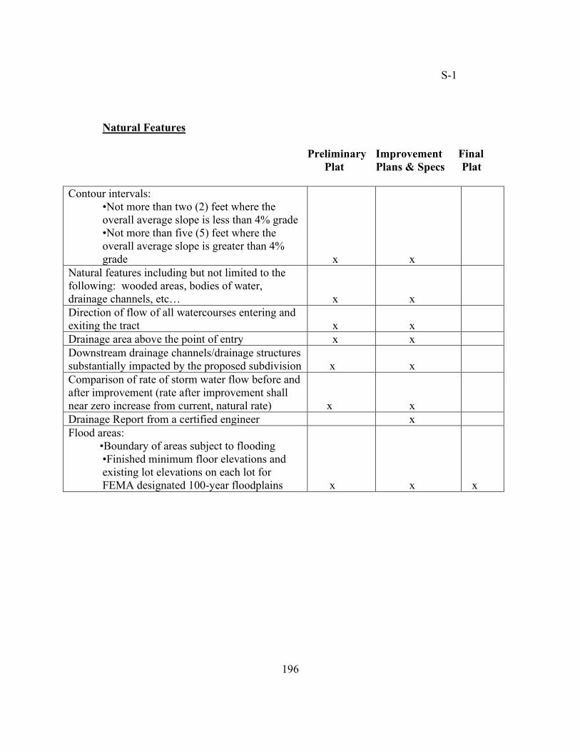
S-1 Natural Features
Preliminary Improvement Final Plat Plans & Specs Plat
Contour intervals: •Not more than two (2) feet where the
overall average slope is less than 4% grade •Not more than five (5) feet where the overall average slope is greater than 4% grade
x
x
Natural features including but not limited to the following: wooded areas, bodies of water, drainage channels, etc…
x
x
Direction of flow of all watercourses entering and exiting the tract
x
x
Drainage area above the point of entry x x Downstream drainage channels/drainage structures substantially impacted by the proposed subdivision
x
x
Comparison of rate of storm water flow before and after improvement (rate after improvement shall near zero increase from current, natural rate)
x
x
Drainage Report from a certified engineer x Flood areas: •Boundary of areas subject to flooding
•Finished minimum floor elevations and existing lot elevations on each lot for FEMA designated 100-year floodplains
x
x
x
196
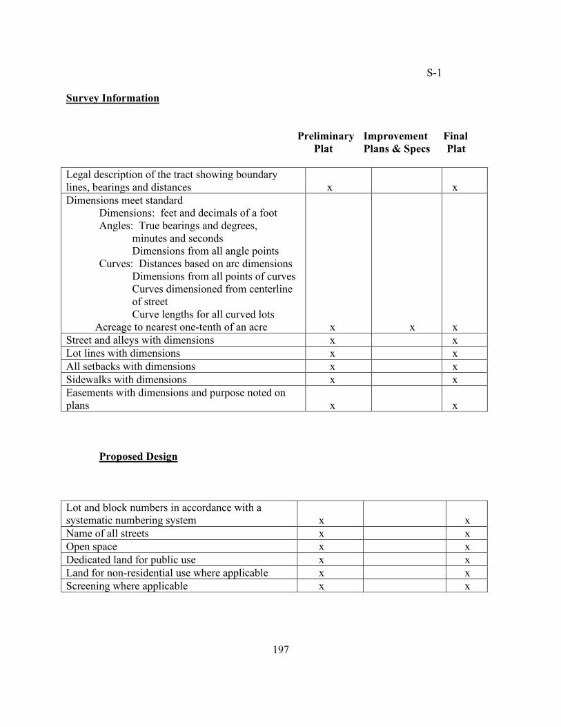
S-1 Survey Information
Preliminary Improvement Final Plat Plans & Specs Plat
Legal description of the tract showing boundary lines, bearings and distances
x
x
Dimensions meet standard Dimensions: feet and decimals of a foot
Angles: True bearings and degrees, minutes and seconds Dimensions from all angle points
Curves: Distances based on arc dimensions Dimensions from all points of curves Curves dimensioned from centerline of street Curve lengths for all curved lots
Acreage to nearest one-tenth of an acre
x
x
x
Street and alleys with dimensions x x Lot lines with dimensions x x All setbacks with dimensions x x Sidewalks with dimensions x x Easements with dimensions and purpose noted on plans
x
x
Proposed Design Lot and block numbers in accordance with a systematic numbering system
x
x
Name of all streets x x Open space x x Dedicated land for public use x x Land for non-residential use where applicable x x Screening where applicable x x
197
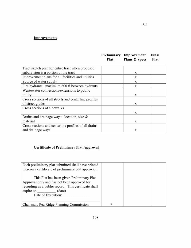
S-1 Improvements
Preliminary Improvement Final Plat Plans & Specs Plat
Tract sketch plan for entire tract when proposed subdivision is a portion of the tract
x
Improvement plans for all facilities and utilities x Source of water supply x Fire hydrants: maximum 600 ft between hydrants x Wastewater connections/extensions to public utility
x
Cross sections of all streets and centerline profiles of street grades
x
Cross sections of sidewalks x
Drains and drainage ways: location, size & material
x
Cross sections and centerline profiles of all drains and drainage ways
x
Certificate of Preliminary Plat Approval Each preliminary plat submitted shall have printed thereon a certificate of preliminary plat approval:
This Plat has been given Preliminary Plat Approval only and has not been approved for recording as a public record. This certificate shall expire on __________ (date)
Date of Execution:_______________
Chairman, Pea Ridge Planning Commission
x
198
S-1
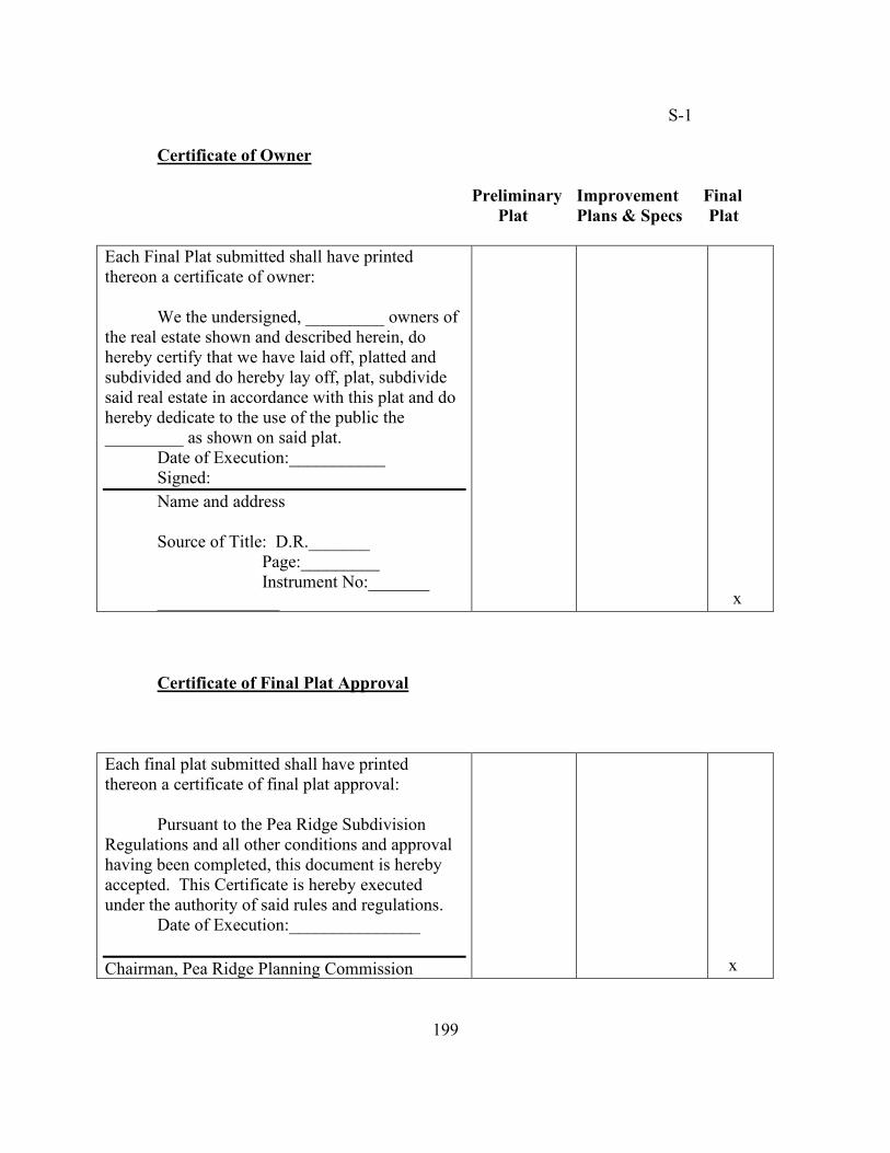
Certificate of Owner
Preliminary Improvement Final Plat Plans & Specs Plat
Each Final Plat submitted shall have printed thereon a certificate of owner:
We the undersigned, _________ owners of the real estate shown and described herein, do hereby certify that we have laid off, platted and subdivided and do hereby lay off, plat, subdivide said real estate in accordance with this plat and do hereby dedicate to the use of the public the _________ as shown on said plat.
Date of Execution:___________ Signed: Name and address Source of Title: D.R._______
Page:_________ Instrument No:_______
______________
x
Certificate of Final Plat Approval Each final plat submitted shall have printed thereon a certificate of final plat approval:
Pursuant to the Pea Ridge Subdivision Regulations and all other conditions and approval having been completed, this document is hereby accepted. This Certificate is hereby executed under the authority of said rules and regulations.
Date of Execution:_______________
Chairman, Pea Ridge Planning Commission
x
199
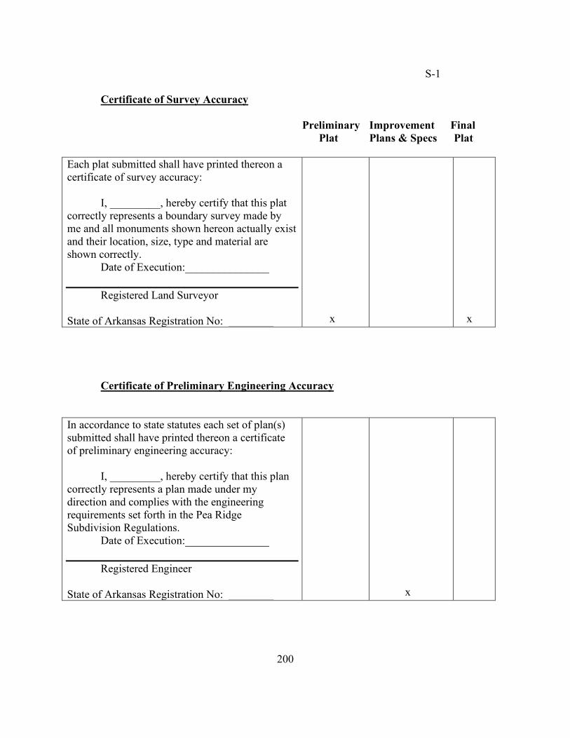
S-1 Certificate of Survey Accuracy
Preliminary Improvement Final Plat Plans & Specs Plat
Each plat submitted shall have printed thereon a certificate of survey accuracy:
I, _________, hereby certify that this plat
correctly represents a boundary survey made by me and all monuments shown hereon actually exist and their location, size, type and material are shown correctly.
Date of Execution:_______________ Registered Land Surveyor
State of Arkansas Registration No: ________
x
x
Certificate of Preliminary Engineering Accuracy In accordance to state statutes each set of plan(s) submitted shall have printed thereon a certificate of preliminary engineering accuracy:
I, _________, hereby certify that this plan
correctly represents a plan made under my direction and complies with the engineering requirements set forth in the Pea Ridge Subdivision Regulations.
Date of Execution:_______________ Registered Engineer
State of Arkansas Registration No: ________
x
200
S-17 15.04.05 Incidental subdivisions A. APPLICABILITY Incidental subdivisions shall include the following:
1. Lot split A division of land creating only one new lot. An original lot, parcel or tract shall be split no more than three times.
2. Minor subdivisions A division of land into three (3) or fewer lots. All subdivision regulations shall apply to minor subdivisions except for the following:
a. Minor subdividers shall not be required to provide an on-site
certified technician for inspection. Instead, the Building Official shall weekly inspect work performed on all improvements of minor subdivisions. A Twenty-Five Dollars ($25.00) fee shall be charged for each inspection.
b. Minor subdivision may follow the administrative review process detailed in subsection B of this section.
(Ord. No. 391, Sec. 7.) 3. Property line adjustment A property line(s) is relocated but does not
create an additional lot. A property line adjustment may or may not dedicate right-of-way and/or utility easements.
B. REVIEW AND APPROVAL Incidental subdivision shall be expedited by consolidating the preliminary and final plat review into a single review process. However, if deemed necessary, an incidental subdivision may be required to follow the formal review process of both a preliminary and final plat review.
1. Submission requirements The subdivider or authorized agent shall submit an application package to the Planning Department containing the following:
a. Application b. Letter of transmittal c. Two (2) copies of the Final Plat in a reproducible from on an 18 x 24 sheet
(Refer to subsection E of 14.04.04 – Plat Checklist for information required on plat. A Preliminary Plat is not required.
d. Six (6) copies of Final Plat on an 18 x 24 sheet. e. One (1) copy of required documents (Refer to subsection E of 15.04.04 –
Plat Checklist for list of documents). f. Fee (Refer to subsection D of 15.04.04 – Schedule of Fees). (Ord. No. 375, Sec. 2; Ord. No. 632, Sec. 4.)
201
S-2
2. Administrative review
a. Applicability the Building Official may review and administratively approve all incidental subdivisions if no dedications, variations, reservations, changes in alignment or extension of utilities are being proposed.
b. Action Within two (2) weeks of receipt of the Final Plat, the Building Official shall disapprove, approve or approve conditionally said plat.
201.1
S-17 (1) Disapproval The Building Official shall send the applicant
a written statement of the reasons for disapproval. (2) Approval The Building Official shall send the applicant a
written statement of the approval. (3) Conditional approval The Building Official shall send the
applicant a written statement of required changes and/or additions. The applicant shall send a copy of the letter with his/her signature to the Building Department.
3. Planning Commission approval
a. Applicability The Planning Commission shall review all incidental subdivisions that are not being administratively approved as set forth in subsection B.2.
b. Action Within forty-five (45) days of receipt of the Final Plat, the Planning Commission shall disapprove, approve or approve conditionally said plat.
(1) Disapproval Within two (2) weeks after the Planning
Commission's decision, the Planning Department shall send the applicant a written statement of the reasons for disapproval.
(2) Approval Within two (2) weeks after the Planning Commission's decision, the applicant shall receive a signed copy of the plat.
(3) Conditional approval Within two (2) weeks after the Planning Commission's decision, the Planning Department shall send the applicant a signed copy of the plat along with a written statement of any required changes and/or additions. The applicant shall send a copy of the letter with his/her signature to the Planning Department.
4. City Council approval Any incidental subdivision that dedicates right-
of-ways or easements shall require approval by the City Council. 5. Recording If the Final Plat is approved by the Planning Commission and
the City Council, the applicant shall record the Final Plat with the County Recorder, and shall send two (2) filed copies of the Final Plat on 18 x 24 paper to the Planning Department (Ord. No. 632, Sec. 5.).
6. Criteria Decisions shall be based on the following:
a. Proposed subdivision complies with the standards as described herein.
b. No new street or alley is required or proposed.
202
S-3 c. No vacation of streets, alleys, setback lines, access control or
easements is required or proposed. d. Such action will not result in any significant increases in public
service requirements, nor will interfere with maintaining existing public service levels.
e. There is adequate street right-of-way as required by these regulations.
f. All easement requirements have been satisfied g. All created lots shall have access to a public street. h. No variance is requested (Ord. No. 372, Sec. 5.)
15.04.06 Improvements and design standards A. SUITABILITY OF LAND FOR PLATTING Land unsuitable for residential occupancy due to flooding or other topographical conditions shall not be platted for any use that may increase the danger to health, life or property; or may aggravate erosion or flood hazard. When such land is in the proposed plat, it shall be set aside for such land uses that will not be affected by periodic flooding or unsuitable topographic conditions unless adequate corrective measures are formulated by the subdivider and approved by the Planning Commission. B. FLOODPLAIN DEVELOPMENT Land may not be platted and subdivided except in conformance with the Drainage regulations as set out in Ch. 11.06. The city will not be financially liable for any damages due to flooding. The Preliminary and Final Plat of any subdivision, wholly or partially, occurring in the 100-year floodplain, as designated by the Federal Emergency Management Agency (FEMA), shall contain finished minimum floor elevations and existing lot elevations on each lot. (Ord. No. 401, Sec. 2.) C. LAND FOR PUBLIC USE Where proposed community or public facilities of the Comprehensive Plan are located, in whole or in part, in a proposed subdivision, the Planning Commission, City Council, or public board shall require that land for those public facilities be reserved as a condition of Preliminary Plat approval. Such reservations shall be referred to the appropriate public board, commission, or body having jurisdiction or financial responsibility to permit the opportunity to acquire said sites either through purchase, taking an option, or the filing of condemnation proceedings under the power of eminent domain. The reservation shall not extend over a period of more than twelve (12) months following the date of approval of the Preliminary Plat by the Planning Commission or the subdivision process shall continue without regard for the proposed community or public facilities.
203
S-1 D. RESPONSIBILITY OF COSTS
1. Streets The subdivider is responsible for the construction of streets not to
exceed thirty-six (36) feet between the backs of curbs. The thirty-six (36) foot wide street is recognized as the standard collector street within the city. The city shall be responsible for costs of widths in excess of thirty-six (36) feet.
a. Local streets The subdivider shall finance all local streets. b. Collector streets The subdivider shall pay for the construction of
collector streets as part of the subdivision. c. Existing boundary streets When the proposed subdivision abuts
an existing street that does not have curb and gutter; does not meet the city's standards of width and construction; and is not included in the city's impact fee plan, the subdivider shall provide payment in-lieu of improvements to upgrade the street to the design standards provided in 15.04.06. Subdivider shall pay no less than one-half of the construction costs.
d. New boundary streets
(1) Shown on Master Street Plan For boundary streets that are in agreement with the Master Street Plan, the subdivider shall pay no less than one-half of the construction costs and dedicate no less than one-half of the required right-of-way. Subsequently, the city shall construct such boundary street within seven (7) years from date of Final Plat approval or shall return the full amount of escrowed money plus interest to the subdivider.
(2) No shown on Master Street Plan If the Planning Commission deems a boundary street (not shown on the Master Street Plan) as unavoidable, the subdivider shall provide for the entire right-of-way and pay for all construction costs.
e. Access streets Service or frontage streets used for access to or
within the subdivision are the subdivider's responsibility to construct.
f. Arterial streets Arterial street design and construction may be handled on a participation basis.
g. Street name signs The subdivider shall pay for street name signs and their installation.
2. Sidewalks The subdivider shall pay for all sidewalks.
204
S-1
3. Storm drainage system The subdivider shall pay for drainage systems within the subdivision including facilities to handle water flowing into and out of the subdivision from adjacent lands. The city may participate in the cost of oversize storm sewer lines. The design characteristics of each development and its provisions for drainage shall also be considered when calculating major drainage improvements.
4. Water supply system The subdivider shall pay for the installation of water lines within the development and the connection to the public water system.
5. Sewer system The subdivider shall pay for the installation of sewerage lines within the development and the connection to the public sewerage system.
6. Other The subdivider shall pay for all other costs not specified in this section.
E. BLOCKS
1. Configuration The length, width and shape of blocks shall be determined by the following:
a. Provision of adequate building sites suitable to the special needs of
the type of use proposed b. Zoning requirements as to lot sizes and dimensions c. Needs for convenient access, circulation, and control and safety of
street traffic d. Limitations and opportunities of topography
2. Size The permitted length of a block is between four hundred (400) feet
and one thousand three hundred and twenty (1,320) feet. Blocks over one thousand (1,000) feet in length may require a public crosswalk within a dedicated easement of not less than fifteen (15) feet in width including a paved crosswalk not less than five (5) feet in width.
3. Business and residential uses Such uses shall have a width suitable for the intended purpose with due allowances for off-street parking and loading facilities.
4. Residential use Residential blocks shall have sufficient width to provide two (2) tiers of lots of appropriate depths except lots fronting a major street or topographical constraints in which case the Planning Commission may approve a single tier of lots.
205
S-1 F. LOTS
1. Relationship to street Every lot shall front on or abut a public street
except for a Planned Unit Development (PUD) where private streets may prevail subject to Planning Commission's approval.
2. Double frontage Lots, other than corner lots, fronting on two (2) streets, shall not be platted except under exceptional circumstances, in which case building lines shall be established on both frontages.
3. Buffer A buffer of at least ten (10) feet wide with no vehicular access shall be placed along the abutting street or other disadvantageous use in all new residential subdivisions. At the discretion of the Planning Commission, the subdivider may substitute an ornamental wall or fence for a planting screen. Screening easements shall be indicated on the plats.
4. Size The size, shape and orientation of every lot shall be as the Planning Commission deems appropriate for the type of development and use. Except as provided herein, the minimum lot dimensions shall conform to the requirements of the Zoning Ordinance for all land within the planning area. No lot shall be more than three (3) times as deep as it is wide.
5. Non-residential use Depth and width of properties reserved or laid out for business or commercial purposes shall be adequate to provide for the off-street parking and loading facilities required for the type of use and development.
6. Building setbacks (Refer to the Pea Ridge Zoning Ordinance for building setbacks by zoning district.)
7. Floodway A minimum building setback line of not less than twenty-five (25) feet shall be from any 100-year floodway boundary (FEMA).
8. Drainage Every lot shall slope to a street or drainage easement.
206
S-15 G. STREETS
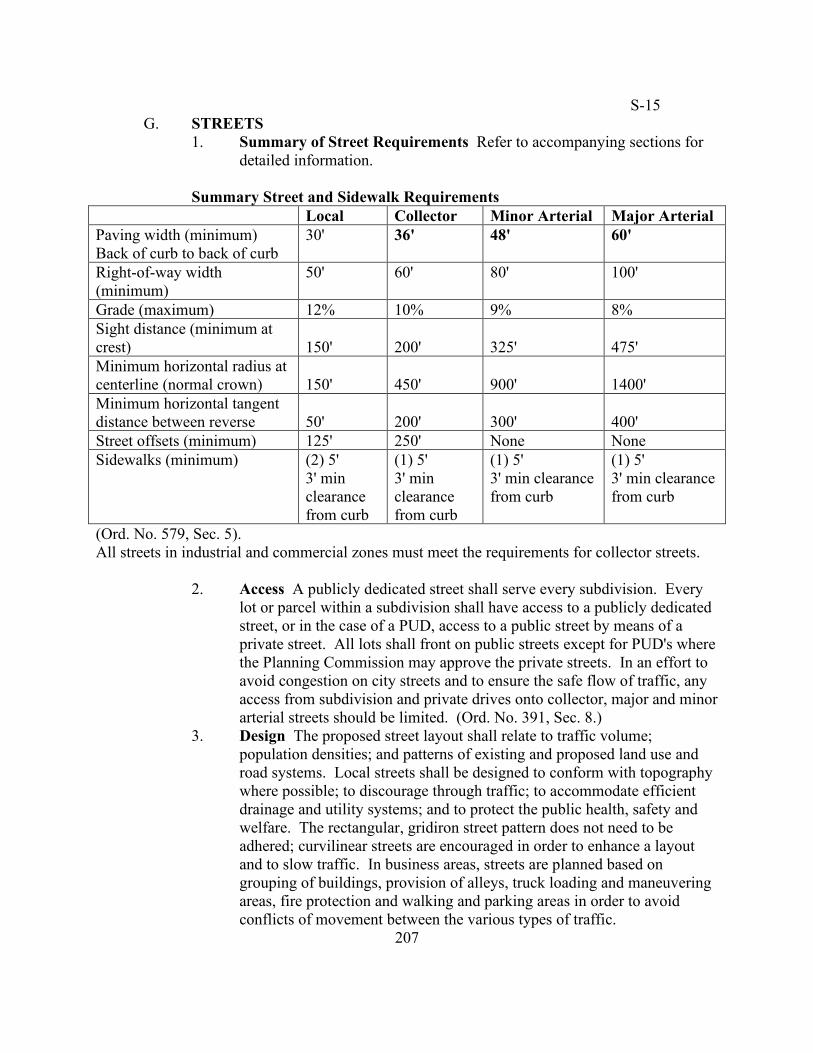
1. Summary of Street Requirements Refer to accompanying sections for detailed information.
Summary Street and Sidewalk Requirements
Local Collector Minor Arterial Major Arterial Paving width (minimum) Back of curb to back of curb
30' 36' 48' 60'
Right-of-way width (minimum)
50' 60' 80' 100'
Grade (maximum) 12% 10% 9% 8% Sight distance (minimum at crest)
150'
200'
325'
475'
Minimum horizontal radius at centerline (normal crown)
150'
450'
900'
1400'
Minimum horizontal tangent distance between reverse
50'
200'
300'
400'
Street offsets (minimum) 125' 250' None None Sidewalks (minimum) (2) 5'
3' min clearance from curb
(1) 5' 3' min clearance from curb
(1) 5' 3' min clearance from curb
(1) 5' 3' min clearance from curb
(Ord. No. 579, Sec. 5). All streets in industrial and commercial zones must meet the requirements for collector streets.
2. Access A publicly dedicated street shall serve every subdivision. Every lot or parcel within a subdivision shall have access to a publicly dedicated street, or in the case of a PUD, access to a public street by means of a private street. All lots shall front on public streets except for PUD's where the Planning Commission may approve the private streets. In an effort to avoid congestion on city streets and to ensure the safe flow of traffic, any access from subdivision and private drives onto collector, major and minor arterial streets should be limited. (Ord. No. 391, Sec. 8.)
3. Design The proposed street layout shall relate to traffic volume; population densities; and patterns of existing and proposed land use and road systems. Local streets shall be designed to conform with topography where possible; to discourage through traffic; to accommodate efficient drainage and utility systems; and to protect the public health, safety and welfare. The rectangular, gridiron street pattern does not need to be adhered; curvilinear streets are encouraged in order to enhance a layout and to slow traffic. In business areas, streets are planned based on grouping of buildings, provision of alleys, truck loading and maneuvering areas, fire protection and walking and parking areas in order to avoid conflicts of movement between the various types of traffic.
207
S-1 4. Future through streets Future through streets shall extend to the
boundary lines of the subdivision unless prevented by topography or other physical conditions or unless, in the opinion of the Planning Commission, such extensions are deemed unnecessary or undesirable for the coordination of the layout of the subdivision with the existing layout or with the most advantageous future development of adjacent property. For partially subdivided land, the subdivider shall provide a proposed plan of future streets for the unsubdivided portion of land.
5. Proposed streets Proposed streets shall extend to and match the widths of existing streets (not in excess of thirty-six feet) which may require the dedication of additional right-of-way.
6. Access control The subdivider shall not retain a parcel, or tract of land lying between a boundary street and a property line in order to avoid instances where abutting properties are prevented access.
7. Lots fronting major streets Residential and non-residential lots fronting a non-local street may be required to have a frontage road to access such lots.
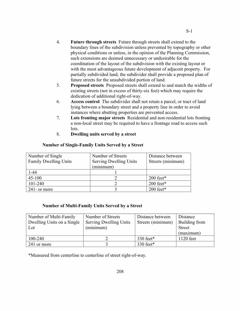
8. Dwelling units served by a street
Number of Single-Family Units Served by a Street Number of Single Family Dwelling Units
Number of Streets Serving Dwelling Units (minimum)
Distance between Streets (minimum)
1-44 1 45-100 2 200 feet* 101-240 2 200 feet* 241- or more 3 200 feet* Number of Multi-Family Units Served by a Street Number of Multi-Family Dwelling Units on a Single Lot
Number of Streets Serving Dwelling Units (minimum)
Distance between Streets (minimum)
Distance Building from Street (maximum)
100-240 2 330 feet* 1120 feet 241 or more 3 330 feet* *Measured from centerline to centerline of street right-of-way.
208
S-1
9. Widths Subdivisions and large-scale developments shall dedicate sufficient right-of-way to bring substandard streets into compliance.
a. Right-of-way widths (minimum) Local: fifty (50) ft. Collector: sixty (60) ft. Cul-de-sac: one hundred twenty (120) ft. (Refer to subsection
G.13 of 15.04.06) Alley: twenty (20) ft. (Refer to subsection G.14 of
15.04.06) b. Paving widths (minimum) (measured from back of curb to back
of curb) Local: thirty (30) ft. Collector: thirty-six (36) ft. Cul-de-sac: twenty-five (25) ft; no curb and gutter required
(Refer to subsection G.13 of 15.04.06) Alley: sixteen (16) ft. (Refer to subsection G.14 of
15.04.06) 10. Grades (maximum) Local: twelve percent (12%) Collector: ten percent (10%) Street grades along gutters shall be 1.5 percent or greater unless approved
by city engineer. 11. Horizontal clearances to obstructions On all streets, a minimum
clearance of one and one-half (1.5) feet shall be provided between the curb face and obstructions. Such obstructions shall include but not be limited to utility poles, lighting poles and fire hydrants but does not include mail boxes.
12. Intersections a. Angles Intersecting streets shall be at right angles (90 degrees)
where possible and shall not be less than seventy-five (75) degrees. b. Offsets Street offset requirements are as follows:
(1) Local streets: centerline offsets of no less than one hundred twenty-five (125 ft.
(2) Collector streets: centerline offset of no less than two hundred fifty (250) ft.
(3) Arterial streets: No offsets are permitted.
209
S-1 c. Sight distances At all intersections, nothing shall be erected,
planted, located or allowed that would impede a motorist's vision between the height of two and one-half (2.5) ft and ten (10) ft. above the highest elevation of the road surface cross section of the intersecting streets. The unobstructed area described is formed by running twenty-five feet in each direction from the right-of-way boundary line. Refer to Figure 4-D.
d. Curb radii Where the angle of street intersection is less than ninety (90) degrees, the Planning Commission may require a greater radius. The minimum requirements for curb radii are as follows:
(1) Local streets: twenty-five (25) ft. (2) Collector streets intersecting collectors and arterials:
thirty-one (31) ft. e. Property line radii The property line corner at a street
intersection shall have a radius of at least twenty-five (25) ft. Where the angle of street intersection is less than ninety (90) degrees, the Planning Commission may require a greater radius.
13. Cul-de-sac Cul-de-sacs shall occur on local streets only. Cul-de-sacs
shall be used only when the land cannot otherwise be reasonably subdivided because cul-de-sacs reduce the number of connections and choices available to other subdivisions and streets. Where cul-de-sac are utilized, pedestrian and bicycle pathways shall be provided to adjacent properties, unless in the opinion of the Planning Commission, such pathway are deemed unnecessary. Temporary dead-end streets designed to provide future connections to adjacent properties may, in the opinion of the Planning Commission, require a temporary turnaround easement. A proper drainage system shall be provided. The right-of-way radius shall not be less than sixty (60) ft. The paving radius shall not be less than fifty (50) ft. from back of curb to back of curb. The paving width shall not be less than twenty-five (25) ft. from back of curb to back of curb. The maximum length for a cul-de-sac (measured from center of radius to centerline of intersecting street) shall not exceed one thousand one hundred twenty (1,120) ft. All lots on cul-de-sacs shall have no less than eighty (80) ft. of width at the building line. Refer to Figure 4-E.
14. Alleys Alleys may be required at the rear of all lots used for non-residential purposes in order to accommodate access for service and emergency vehicles. Alleys that provide access to rear garages are encouraged in residential areas. In residential areas, the minimum paving
210
S-1
width shall not be less than sixteen (16) ft. and the minimum right-of-way width shall not be less than twenty (20) ft. All alleys shall be paved with asphalt or concrete and shall meet the minimum street requirements with the exception that curbs and gutters are not required. No parking lanes shall be provided in alleys.
15. Street name signs Street name signs shall be placed on one (1) corner of each street intersection in conformance with the specifications adopted by the city. The Planning Commission has the authority to determine the street names and require changes to proposed names.
16. Street paving construction
a. Notification The Pea Ridge Street Department shall be notified twenty-four (24) hours prior to soil compaction test and to placement of any fill and paving material; drainage structures; curb and gutter. The subgrade shall be approved by the Pea Ridge Street Department prior to installation of curb and gutter and/o placement of crushed stone.
b. Earthwork equipment Earthwork equipment shall include appropriate type and size to achieve the specified compaction.
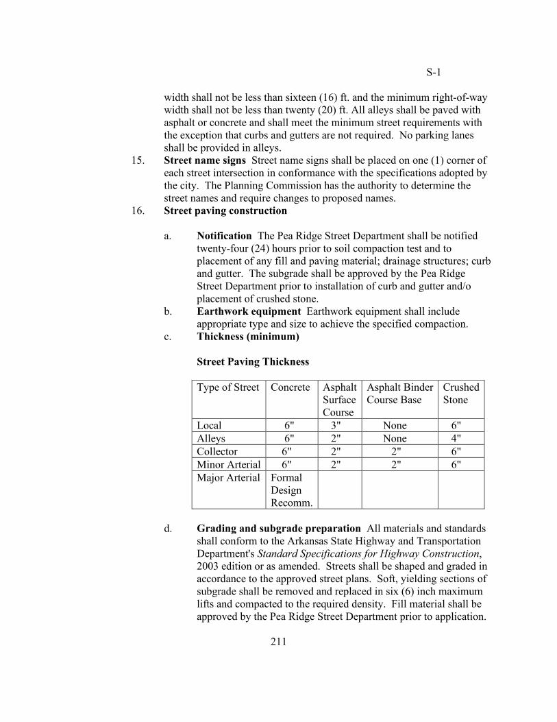
c. Thickness (minimum) Street Paving Thickness
Type of Street Concrete Asphalt Surface Course
Asphalt Binder Course Base
Crushed Stone
Local 6" 3" None 6" Alleys 6" 2" None 4" Collector 6" 2" 2" 6" Minor Arterial 6" 2" 2" 6" Major Arterial Formal
Design Recomm.
d. Grading and subgrade preparation All materials and standards
shall conform to the Arkansas State Highway and Transportation Department's Standard Specifications for Highway Construction, 2003 edition or as amended. Streets shall be shaped and graded in accordance to the approved street plans. Soft, yielding sections of subgrade shall be removed and replaced in six (6) inch maximum lifts and compacted to the required density. Fill material shall be approved by the Pea Ridge Street Department prior to application.
211
S-2 No topsoil or organic material is permitted as fill material. Prior to placement of crushed stone base course, the subdivider shall contact the street department to observe testing for the minimum required density of subgrade by an approved laboratory and to verify that the subgrade is free of soft spots and is unyielding to equipment being used.
e. Asphalt street standards All materials and standards shall conform to the Arkansas State Highway and Transportation Department's Standard Specifications for Highway Construction, 2003 edition or as amended. All references below are to said document. (1) Base The base course shall consist of crushed stone in
accordance with Section 303 and shall meet the requirements of a Class 7 as specified in Table 303.1. Construction requirements shall meet the standards specifications in Section 303.03.
(2) Surface course The surface course shall consist of asphalt concrete hot mix and conform to the properties for a Type 3 as specified in Table 407.1. Materials of construction requirements shall be accordance with Sections 409 and 410.
(3) Binder course The binder course shall consist of asphalt concrete hot mix and conform to the properties for a Type 2 as specified in Table 406.1. Construction requirements shall be in accordance with Sections 409 and 410.
f. Concrete street standards All materials and standards shall conform to the Arkansas State Highway and Transportation Department's Standard Specifications for Highway Construction, 2003 edition or as amended. Refer to Section 501 of said document for required materials and Section 502 for reinforcement and dowel requirements.
g. Alleys Alleys shall be paved with concrete or asphalt. Alleys may have a center depression in order to channel water longitudinally to a street and/or storm drainage system.
17. Affected roads These regulations apply to any road which a subdivision encompasses or borders and excludes roads listed on the impact fee list of roads. (Ord. No. 391, Sec. 9.)
H. SIDEWALKS
1. Location within the right-of-way Sidewalks shall be located within the dedicated public right-of-way adjacent to the property line unless as otherwise specified in this section. Sidewalks shall be located no less than three (3) ft from back of curb.
212
S-1 2. Side of the streets
a. Local streets Sidewalks shall be required on both sides of the street.
b. Collector streets Sidewalks on one side of a collector street are required unless, in the opinion of the Planning Commission, sidewalks on both sides of the street will protect public health, safety and welfare and will facilitate pedestrian safety and access.
c. Major and minor arterial streets Sidewalks shall be required on one side of the street.
3. Width a. Residential sidewalks Five (5) ft. wide minimum. b. Non-residential sidewalks Five (5) ft. wide, unless, in the
opinion of the Planning Commission, wider sidewalks will protect public health, safety and welfare and will facilitate pedestrian safety and access. (Ord. No. 579, Sec. 6).
4. Design a. ADA All sidewalks shall conform to the "Americans with
Disabilities Act" (ADA) requirements and specifications. b. Alignment Sidewalks are to be installed in a straight line unless,
in the opinion of the Planning Commission, deviations from a straight line would protect a natural feature or is inclusive of an aesthetic design.
c. Connections Sidewalks shall connect with existing sidewalks on adjoining properties in order to create continuity for pedestrian flow throughout the community.
5. Construction a. Subgrade All sidewalks shall be constructed on a compacted
subgrade which is free of dust pockets, ruts and other defects. The Planning Commission or street department supervisor may required four (4) inches of base if the subgrade is not compacted.
b. Compressive strength All sidewalks shall be constructed of Portland cement concrete with a minimum twenty-eight day compressive strength of three thousand (3,000) pounds per square inch.
c. Thickness Sidewalk thickness shall be four (4) inches.
213
S-15 d. Slope All sidewalks shall be constructed with a minimum
transverse slope of one-fourth (1/4) inch per foot. e. Expansion joints All sidewalks shall have expansion joints
spaced no farther than twenty-five (25) ft. apart. f. Transverse joints All sidewalks shall have transverse joints at
five (5) ft. intervals and one-fourth (1/4) wide. Joint depth shall be one (1) inch.
g. Finish All sidewalks shall have a "broom" finish.
6. Waiver The Planning Commission may waive the sidewalk requirements in the following cases:
a. Where sidewalks are not deemed necessary for public safety or
where topographical or other conditions make their installation and use impractical
b. Where the subdivision designer has submitted for review a proposed sidewalk plan that provides more direct and safer movement of pedestrian traffic.
c. Where sidewalks are made unnecessary by alternative pedestrian systems with low traffic volume
d. Where no public benefit results from the installation of sidewalks.
7. Time of installation Sidewalks, as required in this subsection, shall be installed and maintained to the original specifications in order to receive a certificate of occupancy from the city of Pea Ridge. (Ord. No. 579, Sec. 6). a. After Final Plat approval If the subdivider or builder chooses to
complete the sidewalks within dedicated areas after Final Plat approval, in order to avoid damage to sidewalks by heavy equipment during construction, he/she must provide a cash deposit or a performance bond/letter of credit. (Refer to subsection C.5.C of 15.04.05)
b. Before Final Plat approval If the subdivider chooses to complete the sidewalks prior to Final Plat approval, they shall maintain sidewalks to original specification in order to receive a Certificate of Occupancy.
I. EASEMENTS
1. Open space Easements shall be considered as an opportunity for an open space system for adjoining subdivisions via pedestrian trails and bicycle pathways.
2. Widths Easement widths shall be in conformance to the requirements as dictated by the city of Pea Ridge for the intended purposes.
214
S-19 3. Encroachment No building or structure shall be erected over or within an
easement. 4. Utility easement In all new residential subdivisions, all utilities including
storm water, cable television, electrical and telephone distribution systems or other services shall be laid underground. It shall be the responsibility of the subdivider to initiate any request for exception to the laying of underground utilities. Utility easements shall be at least twenty (20) feet wide and shall be established at the front, rear and along other such lot lines as to provide continuity of alignment from block to block.
5. Drainage easement Where a subdivision is traversed by a watercourse, drainage-way, channel or stream, a drainage easement shall be provided conforming substantially to the lines of the watercourse and shall be adequate for intended purpose. It is desirable for the banks of an open channel to be landscaped.
J. STORMWATER DRAINAGE
1. Drainage Regulations All subdivision development must be done in conformance with the Drainage Regulations as set out in Ch. 11.06.
2. Drainage ditches No open drainage channels shall be constructed within the area dedicated as public streets and alleys. Whenever drainage ditches are existing or installed, such ditches shall have concrete bottom and sidewalls designed to retain their original design characteristics and designed so they can at all times be kept clean and easily maintained.
3. Curb and gutter Curb and gutters shall be installed on all public streets. Installation shall be in accordance with the city's specifications. Curbs shall be roll curb three (3) or six (6) inches high and twenty-four (24) inches wide. The method of construction of the curb and gutter shall be in conformance with methods provided in Item 634 of the Arkansas State Highway and Transportation Department's 2003 edition of the Standard Specifications for Highway Construction, or the latest edition.
4. Construction Construction. All storm drainage pipes shall be reinforced concrete pipe (RCP) Class III (or higher) or high-performance polypropylene pipe (PP) from back-of-curb to back-of-curb in City Right of Way for local and minor collector designated roads unless otherwise specifically approved by the City Engineer. High-density polyethylene pipe (HDPE) may be used behind the curb within the City Right of Way for local and minor collector designated roads. All storm drainage pipes shall be reinforced concrete pipe (RCP) Class III (or higher) or high-performance polypropylene pipe (PP) in City Right of Way for major collector and arterial designated roads unless otherwise specifically
215
S-19
approved by the City Engineer. Outside of the City Right of Way, only high-density polyethylene (HDPE), corrugated metal pipe (CMP), reinforced concrete pipe (RCP) Class III (or higher) or high-performance polypropylene pipe (PP) may be used unless otherwise specifically approved by the City Engineer. Expansion joints shall be of one-half (1/2) inch premolded material and be provided at each side of drainage structures, at the ends of the radii at intersections and cul-de-sacs and along the length of the curb and gutter at one hundred (100) foot spacing. Storm drainage pipes, ditches and drainage structures shall be free of sediments, trash, debris, and ponding water before Final Plat approval. (Ord. No. 401, Sec. 3; Ord. No. 663, Sec. 1.)
K. OFF-SITE IMPROVEMENTS The developer may be required to install off-
site improvements where the need for such improvements is created in whole or in part by the proposed development. An off-site improvement shall mean all or any part of a street, surface drainage system, water system, or sanitary sewer system, which is to be installed on property located outside the proposed development. Any required off-site improvements shall be installed according to city specifications. The developer shall be required to bear the portion of the cost of off-site improvements which bears a rational nexus to the needs created by the proposed development. (Ord. No. 372, Sec. 6.) 15.04.07 Utilities A. GENERAL
1. Coordination The subdivider shall coordinate with the city of Pea Ridge and other local utility companies the design, supply and installation of all utilities serving the subdivision within the planning area of the city of Pea Ridge.
2. Specifications All utilities shall comply with the city of Pea Ridge utility specifications.
3. Location of utilities Utilities within a subdivision shall be located within the dedicated public rights-of-way or appropriately dedicated easements.
4. Utility installation after street paving If stubs to the property lines are not installed, connections between the lots and the utility lines shall be made without breaking into the street surface where possible.
5. Underground All utility wires, lines, and/or cables in new subdivisions utilized by electric and/or telecommunications companies shall be placed underground. Overhead wires, supporting structures and associated structures of temporary nature which provide temporary service are exempt from this requirement.
216
S-2 B. WATER SUPPLY
1. Design The water supply and distribution system shall be designed to
provide the anticipated water consumption within the subdivision including fire protection. Sound engineering methods shall be used to design the system.
2. Connection Where a public water supply is available within the planning jurisdiction, the subdivider shall install or have installed a system of water mains and connect to such supply.
3. Fire hydrants Fire hydrants shall be required in all subdivisions and shall be installed by the subdivider. They shall be located as to adequately protect each lot within the subdivision. The maximum distance between fire hydrants shall be six hundred (600) feet as per the city of Pea Ridge utility specifications. The Planning Commission may require appropriate spacing in non-residential areas. Fire hydrant location shall be approved by the Planning Commission.
C. SANITARY SEWAGE DISPOSAL
1. Design The sewage collection system shall be designed to handle the anticipated flow of sewage from within the subdivision including development of future sections of the same subdivision and adjacent areas within the same drainage basin or pump station service area. Recognized engineering design criteria in accordance with the requirements of the State Department of Health and the city of Pea Ridge utility specifications shall be utilized to design the system.
2. Connection Where a public sanitary sewer is available within the planning jurisdiction, the subdivider shall install a system of sewer lines and provide connection to each lot. Connection to the city's sanitary sewer system shall be required except where the Planning Commission determines that such connections will require unreasonable expenditure when compared with other methods of appropriate sewage disposal.
3. Installation before street paving Such sanitary sewage system shall be installed prior to the installation of the street pavement.
4. Surface discharge Any surface discharge of storm water shall be in accordance with requirements of the Arkansas Department of Pollution control and Ecology. The downstream drainage route for any surface discharge shall be shown on the plat to the point of connection to a natural drainage bed. (Ord. No. 372, Sec. 7.)
5. Inspection All sewer lines installed as part of an improvement shall be inspected by camera, at the expense of the subdivider, at no cost to the city, prior to final plat approval. (Ord. No. 391, Sec. 11.)
217
S-11
D. PRIVATE WATER SUPPLY, SEPTIC TANKS AND ABSORPTION SYSTEMS
1. Tests and documentation
a. Sanitary sewer Where public sanitary sewer is not accessible, a certificate or letter from the State Health Department shall be submitted to the Planning Department showing the results of soil morphology or percolation tests for septic tanks and a statement as to the ability of soil to absorb water. The letter or certificate must state that the septic tank meets the requirements of the State Health Department.
b. Water supply Where a water supply system is not available, a letter from the County Health Department shall be submitted to the Planning Department providing the recommended depth of wells if known, and stating that the well meets the requirements of the County Health Department. If the well depth is unknown, the subdivider shall sink a test well to enable the county health officer to evaluate the adequacy of the individual well water supply.
2. Compliance Whenever an on-site septic tank and an absorption system or
water supply is to be provided, such facilities shall be installed by the builders of the improvements in accordance with regulations and in compliance with the standards of the State and County Department of Health.
E. STREET LIGHTING Street lighting shall be required within all subdivisions
within the city’s corporate limits and its Planning Area in accordance with the standards and spacing prescribed. Lights shall be installed at least one per intersection and a maximum of three hundred (300) feet apart.
1. Design Street light fixtures shall conform to the following specifications
and design criteria: Pole a. Type- direct burial b. Construction materials – fiberglass
(1) coatings – polyurethane (tested in accordance with ASTM G-53)
c. Shaft length – 24 ft.
218
S-11
d. Diameter: (1) top – 2.9 inches (2) base – 6.6 inches e. Mounting height – 20 ft. f. Shaft length – 24 ft. g. Handhold: (1) location from base – 66 inches (2) shape – oval (3) size – 2.5 inches x 5 inches h. Conductor entrance: (1) number – 2 each (2) location from base – 24 inches (3) size – 1.5 inches i. Color – gray or black Shielding a. Type – pole top b. Construction materials – die-cast aluminum housing, spun
aluminum hood c. Power wattage – 175 minimum d. Reflector – choice of glass, acrylic or polycarbonate e. Effective projected area (illumination) – 1.3 sq. ft. f. Voltage – 120V g. Color – gray or black
2. Connection The subdivider shall coordinate with the city of Pea Ridge and the company providing electric power to the subdivision for installation of the street light fixtures and connection of service to the street light fixtures. (Ord. No. 544, Sec. 1.)
219
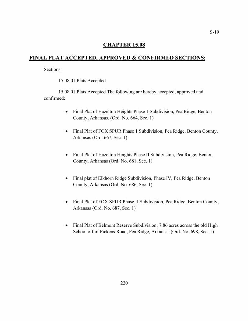
S-19
CHAPTER 15.08
FINAL PLAT ACCEPTED, APPROVED & CONFIRMED SECTIONS:
Sections: 15.08.01 Plats Accepted
15.08.01 Plats Accepted The following are hereby accepted, approved and confirmed:
• Final Plat of Hazelton Heights Phase 1 Subdivision, Pea Ridge, Benton
County, Arkansas. (Ord. No. 664, Sec. 1)
• Final Plat of FOX SPUR Phase 1 Subdivision, Pea Ridge, Benton County, Arkansas (Ord. 667, Sec. 1)
• Final Plat of Hazelton Heights Phase II Subdivision, Pea Ridge, Benton County, Arkansas (Ord. No. 681, Sec. 1)
• Final plat of Elkhorn Ridge Subdivision, Phase IV, Pea Ridge, Benton County, Arkansas (Ord. No. 686, Sec. 1)
• Final Plat of FOX SPUR Phase II Subdivision, Pea Ridge, Benton County, Arkansas (Ord. No. 687, Sec. 1)
• Final Plat of Belmont Reserve Subdivision; 7.86 acres across the old High School off of Pickens Road, Pea Ridge, Arkansas (Ord. No. 698, Sec. 1)
220