Embed Size (px)
Citation preview
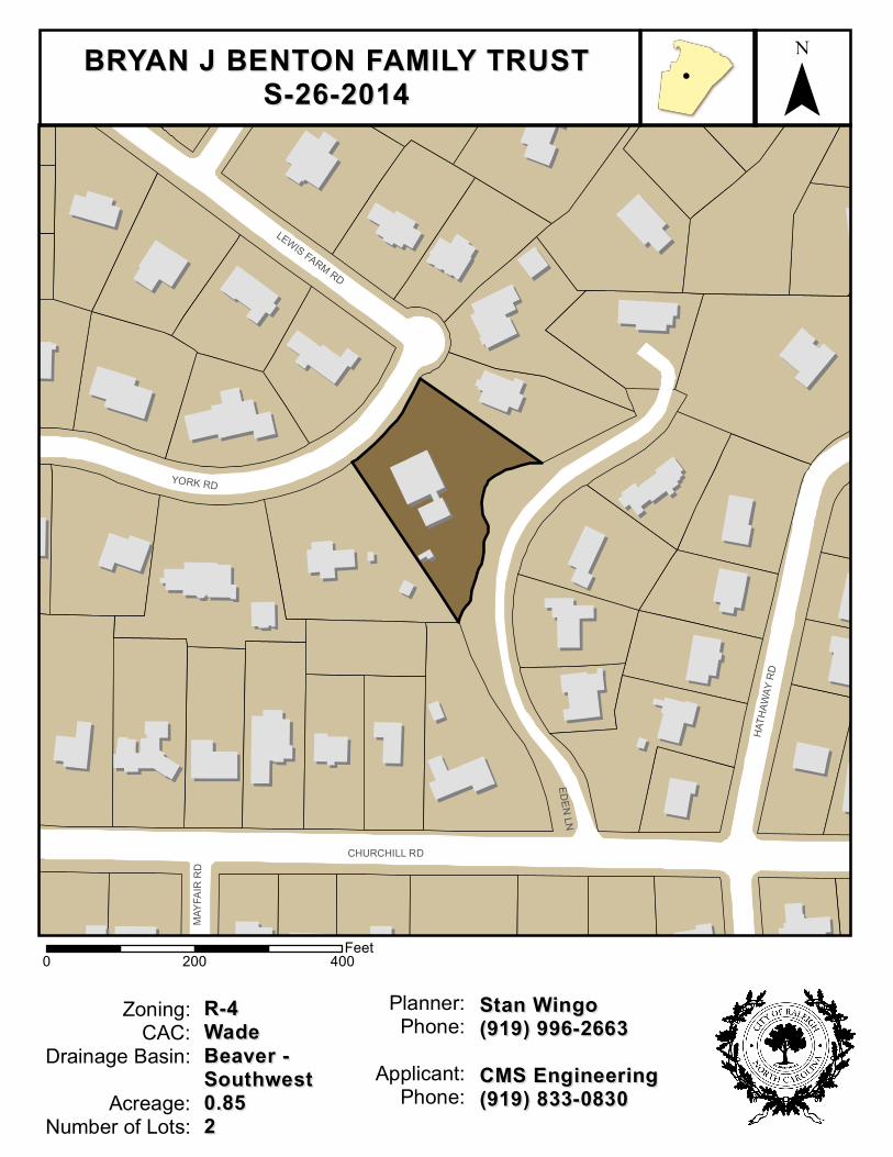
CHURCHILL RD
EDEN LN
YORK RD
HATH
AWAY
RD
LEWIS FARM RD
MAYF
AIR
RD
Zoning:CAC:
Drainage Basin:Acreage:
Number of Lots:
R-4R-4WadeWadeBeaver -Beaver -SouthwestSouthwest0.850.8522
0 400200 Feet
Planner:Phone:
Applicant:Phone:
Stan WingoStan Wingo(919) 996-2663(919) 996-2663CMS EngineeringCMS Engineering(919) 833-0830(919) 833-0830
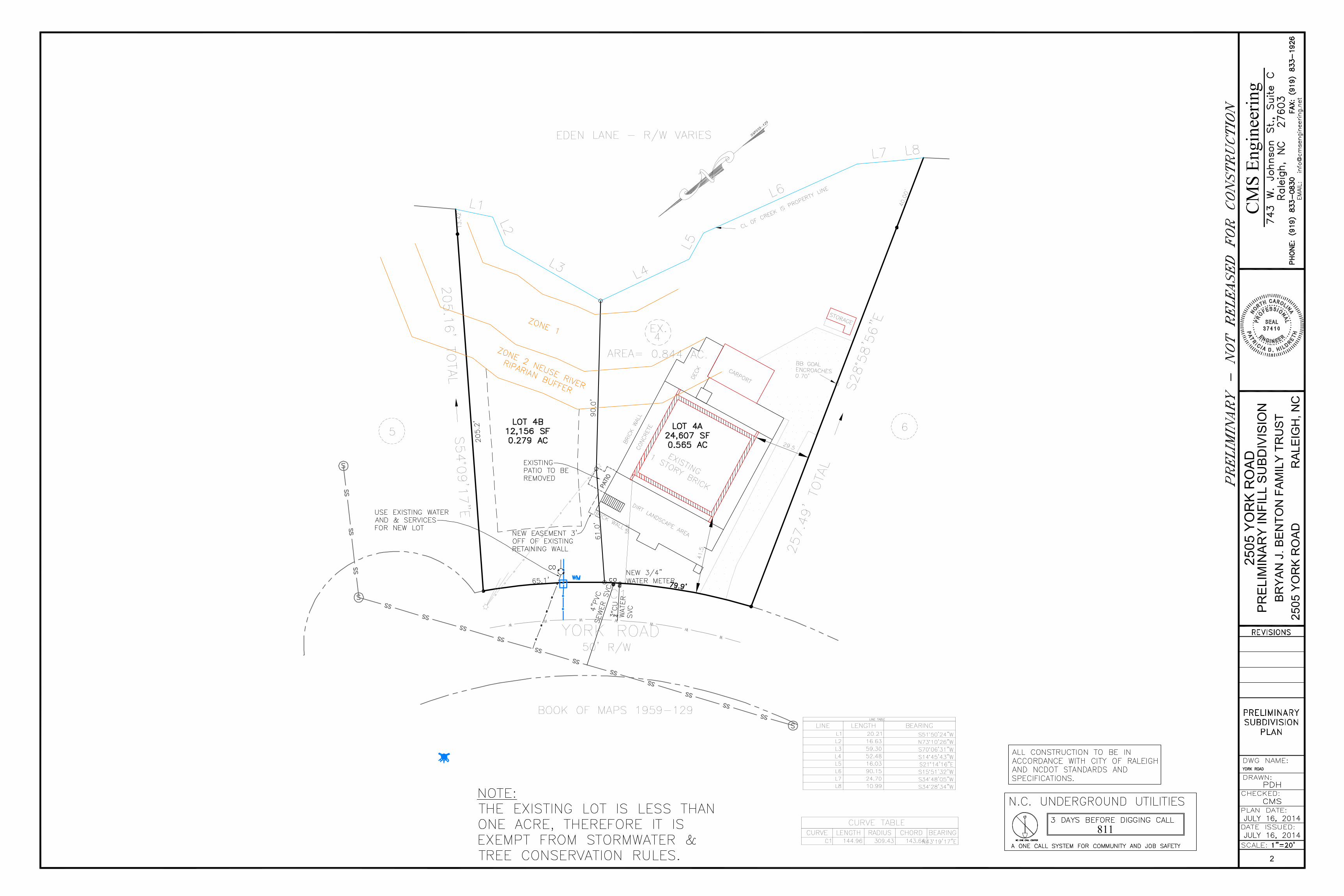
BRYAN J BENTON FAMILY TRUSTBRYAN J BENTON FAMILY TRUSTS-26-2014S-26-2014
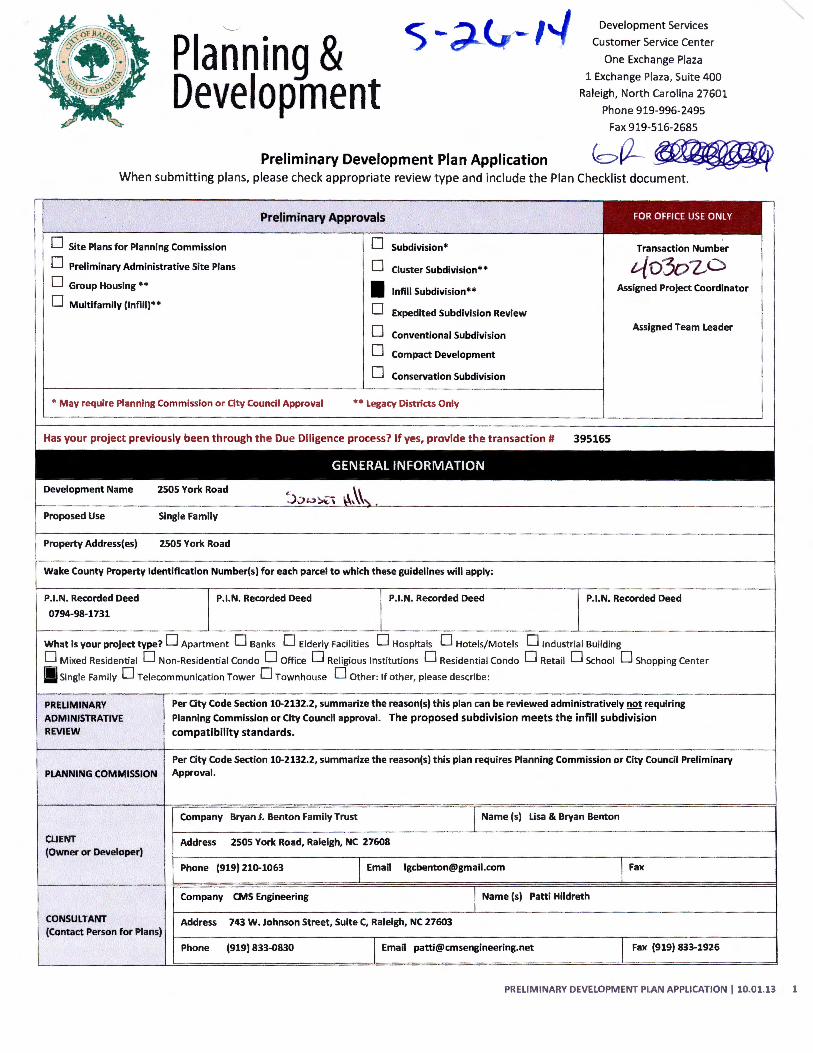
Planning & Development
s-~ I Development Services
Customer Service Center
One Exchange Plaza
1 Exchange Plaza, Suite 400
Raleigh, North Carolina 27601
Phone 919-996-2495
Fax 919-516-2685
Preliminary Development Plan Application bC2-~ When submitting plans, please check appropriate review type and include the Plan Checkl ist document.
D Site Plans for Planning Commission
D Preliminary Administrative Site Plans
D Group Housing **
Preliminary Approvals
D Subdivision*
D
• Cluster Subdivision**
lnfill Subdivision**
Transaction Number
Assigned Project Coordinator
D Multifamily (lnfill)** D Expedited Subdivision Review
* May require Planning Commission or City Council Approval
D D
Conventional Subdivision
Compact Development
D Conservation Subdivision
** legacy Districts Only
Assigned Team leader
Has your project previously been through the Due Diligence process? If yes, provide the transaction# 395165
GENERAL INFORMATION
Development Name 2505 York Road ~).:>o~\ \-\~\,
Proposed Use Single Family
Property Address(es) 2505 York Road
Wake County Property Identification Number(s) for each parcel to which these guidelines will apply:
P.I.N. Recorded Deed P.I.N. Recorded Deed P.I.N. Recorded Deed P.I.N. Recorded Deed
0794-98-1731
What is your project type? D Apartment D Banks D Elderly Facilities D Hospitals D Hotels/Motels D industrial Building
D Mixed Residential D Non-Residential Condo D Office D Religious Institutions D Residential Condo D Retail D School D Shopping Center
!J Single Family D Telecommunication Tower 0 Townhouse 0 Other: If other, please describe :
PRELIMINARY Per City Code Section 10-2132.2, summarize the reason(s) this plan can be reviewed administratively not requiring
ADMINISTRATIVE Planning Commission or City Council approval. The proposed subdivision meets the infill subdivision REVIEW compatibility standards.
Per City Code Section 10-2132.2, summarize the reason(s) this plan requires Planning Commission or City Council Preliminary
PLANNING COMMISSION Approval.
Company Bryan J. Benton Family Trust I Name (s) lisa & Bryan Benton
CLIENT Address 2S05 York Road, Raleigh, NC 27608 (Owner or Developer)
Phone {919) 210-1063 I Email [email protected] I Fax
Company CMS Engineering I Name (s) Patti Hildreth
CONSULTANT Address 743 W. Johnson Street, Suite C, Raleigh, NC 27603 (Contact Person for Plans)
Phone {919) 833-0830 I Email [email protected] I Fax {919) 833-1926
PRELIMINARY DEVELOPMENT PLAN APPLICATION 110.01.13 1
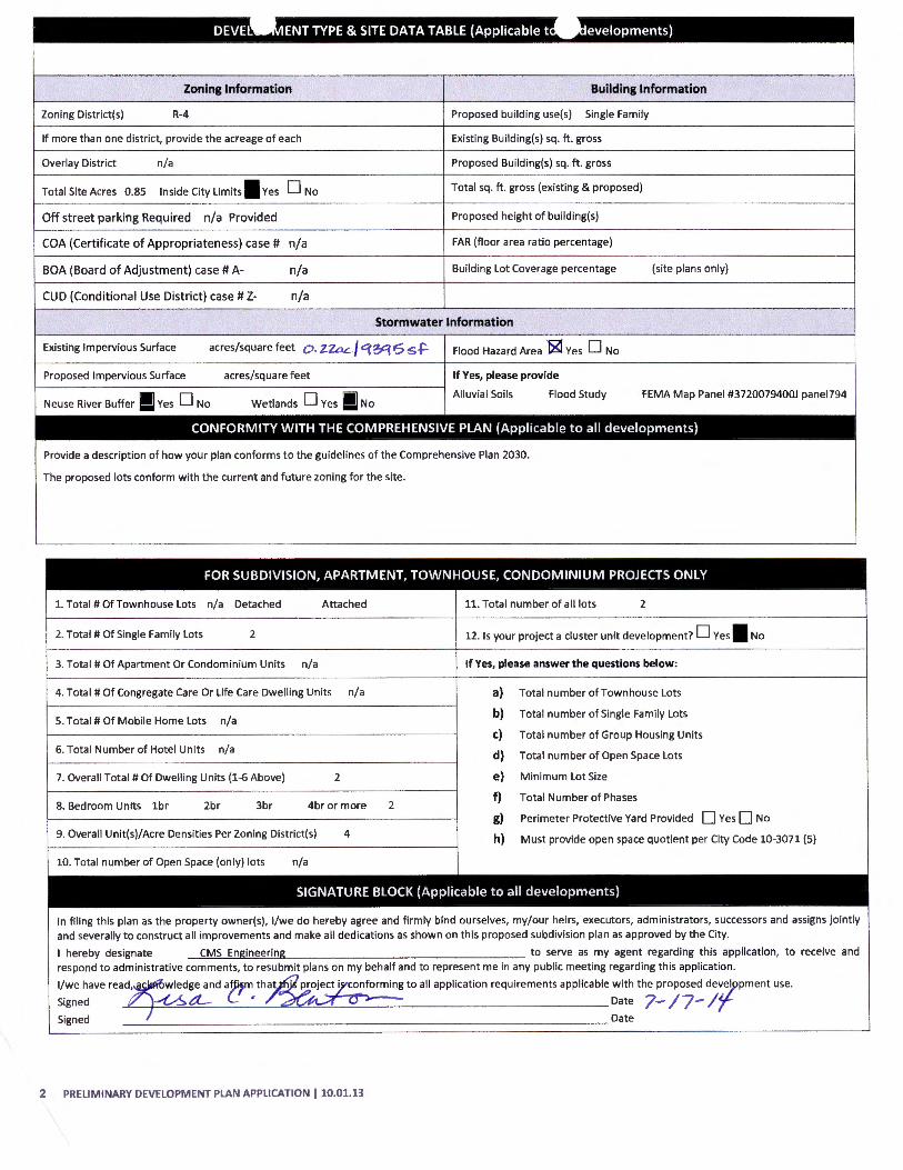
Zoning Information Building Information
Zoning District(s) R-4 Proposed building use(s) Single Family
If more than one district, provide the acreage of each Existing Building(s) sq. ft. gross
Overlay District n/a Proposed Building(s) sq. ft. gross
Total Site Acres 0.85 Inside City Limits I Yes 0 No Total sq . ft. gross (existing & proposed)
Off street parking Required n/a Provided Proposed height of building(s)
COA (Certificate of Appropriateness) case# n/a FAR (floor area ratio percentage)
BOA (Board of Adjustment) case# A- n/a Building Lot Coverage percentage (site plans only)
CUD (Conditional Use District) case# z- n/a
Stormwater Information
Existing Impervious Surface acres/square feet o . Z.ZaL / qy:p5 s .f- Flood Hazard Area ~Yes 0 No
Proposed Impervious Surface acres/square feet If Yes, please provide
Neuse River Buffer I Yes 0 No Wetlands 0 Yes I No Alluvial Soils Flood Study FEMA Map Panel #3720079400J panel794
CONFORMITY WITH THE COMPREHENSIVE PLAN (Applicable to all developments)
Provide a description of how your plan conforms to the guidelines of the Comprehensive Plan 2030.
The proposed lots conform with the current and future zoning for the site.
FOR SUBDIVISION, APARTMENT, TOWNHOUSE, CONDOMINIUM PROJECTS ONLY
1. Total# OfTownhouse Lots n/a Detached Attached 11. Total number of all lots 2
2. Total# Of Single Family Lots 2 12. Is your project a cluster unit development? 0 Yes I No
3. Total# Of Apartment Or Condominium Units n/a If Yes, please answer the questions below:
4. Total# Of Congregate Care Or Life Care Dwelling Units n/a a) Total number of Townhouse Lots
5. Total# Of Mobile Home Lots n/a b) Total number of Single Family Lots
c) Total number of Group Housing Units 6. Total Number of Hotel Units n/a d) Total number of Open Space Lots
7. Overall Total# Of Dwelling Units (1-6 Above) 2 e) Minimum Lot Size
8. Bedroom Units 1br 2br 3br 4br or more 2 f) Total Number of Phases
g) Perimeter Protective Yard Provided 0 YesO No
9. Overall Unit(s)/Acre Densities Per Zoning District(s) 4 h) Must provide open space quotient per City Code 10-3071 (5)
10. Total number of Open Space (only) lots n/a
SIGNATURE BLOCK (Applicable to all developments)
In filing this plan as the property owner(s), 1/we do hereby agree and firmly bind ourselves, my/our heirs, executors, administrators, successors and assigns jointly and severally to construct all improvements and make all dedications as shown on this proposed subdivision plan as approved by the City.
I hereby designate CMS Engineering to serve as my agent regarding this application, to receive and respond to administrative comments, to resubmit plans on my behalf and to represent me in any public meeting regarding this application.
1/we have read, wledge and a~m that · project i conforming to all application requirements applicable with the proposed de~ey>pment use.
Signed ~t:l- C ' Date 7-/7- /{ Signed Date
2 PRELIMINARY DEVELOPMENT PLAN APPLICATION 110.01.13
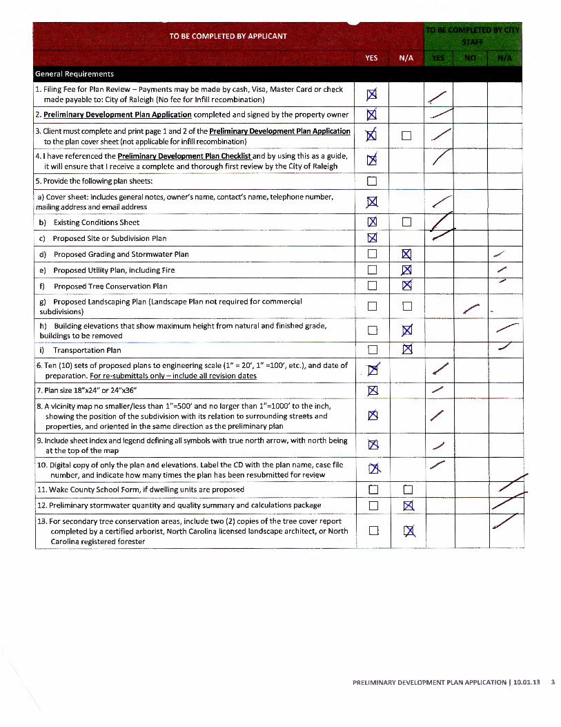
1. Filing Fee for Plan Review- Payments may be made by cash, Visa , Master Card or check made payable to: City of Raleigh (No fee for lnfill recombination)
2. Preliminary Development Plan Application completed and signed by the property owner
3. Client must complete and print page 1 and 2 of the Preliminary Development Plan Application to the plan cover sheet (not applicable for infill recombination)
4. I have referenced the Preliminary Development Plan Checklist and by using this as a guide, it will ensure that I receive a complete and thorough first review by the City of Raleigh
5. Provide the following plan sheets:
a) Cover sheet: includes general notes, owner's name, contact's name, telephone number, mailing address and email address
b) Existing Conditions Sheet
c) Proposed Site or Subdivision Plan
d) Proposed Grading and Stormwater Plan
e) Proposed Utility Plan, including Fire
f) Proposed Tree Conservation Plan
g) Proposed Landscaping Plan (Landscape Plan not required for commercial subdivisions)
h) Building elevations that show maximum height from natural and f inished grade, buildings to be removed
i) Transportation Plan
6. Ten (10) sets of proposed plans to engineering scale (1" = 20', 1" =100', etc.), and date of preparation. For re-submittals only- include all revision dates
7. Plan size 18"x24" or 24"x36"
8. A vicinity map no smaller/less than 1"=500' and no larger than 1" =1000' to the inch, showing the position of the subdivision with its relation to surrounding streets and properties, and oriented in the same direction as the preliminary plan
9. Include sheet index and legend defining all symbols with true north arrow, with north being at the top of the map
10. Digital copy of only the plan and elevations. Label the CD with the plan name, case file number, and indicate how many times the plan has been resubmitted for review
11. Wake County School Form, if dwelling units are proposed
12. Preliminary stormwater quantity and quality summary and calculations package
13. For secondary tree conservation areas, include two (2) copies of the tree cover report completed by a certified arborist, North Carolina licensed landscape architect, or North Carolina registered forester
~·
0
0 0 0
0 0 /
D ~ ~
0
•J21 / ./
/
./
/
0 0 0 ~
0 ~
PRELIMINARY DEVELOPMENT PLAN APPLICATION I 10.01.13 3