Embed Size (px)
Citation preview

WATER RESOURCE PROTECTION PLAN
JUNE 2008
S e c t i o n 9
Watershed Protection

WATER RESOURCE PROTECTION PLAN Section 9
June 2008 9-1
9. WATERSHED PROTECTION
A watershed is the area of land where all of the water that is under it or drains off of it goes into the same place. John Wesley Powell, scientist geographer, put it best when he said that a watershed is:
"that area of land, a bounded hydrologic system, within which all living things are inextricably linked by their common water course and where, as humans settled, simple logic demanded that they become part of a community."
Watersheds come in all shapes and sizes. They cross county, state, and national boundaries. No matter where you are, you're in a watershed!
– U.S. EPA Office of Water1 The public-stewardship ethic is a key component in watershed protection. The small, repetitive actions of individuals can produce detrimental, cumulative effects within the watershed. As noted by John Wesley Powell, all living things–plants, animals, microorganisms, and people–are inextricably linked in the watershed. The impacts and subsequent “ripple effect” of human activities, as demonstrated by past instances of environmental degradation, can be devastating to natural systems. In order to ensure watershed sustainability and maintain a healthy human environment, it is necessary to minimize pollution, mitigate impacts, and promote stewardship within the watershed community. Most modern watershed protection and management programs have sprung from the Clean Water Act of 1977 and subsequent supporting legislation. The State of Hawaii has a long history of watershed protection programs. State programs were initiated specifically to ensure a sustainable water supply. This section of the WRPP describes watershed-protection resources and programs currently being implemented at the federal, State, and local levels and summarizes community efforts and partnership projects that have achieved success in Hawaii. The section concludes with recommendations that encourage more integrated watershed management by building upon existing programs to link mountain- and shoreline-area activities.
9.1. Goals and Objectives
CWRM supports watershed protection and management, including preservation of instream uses, flood control, and the conjunctive use of surface and ground water. The term “watershed” or “watershed management” is not defined in the State Water Code, but the watershed concept and watershed management practices, based on watershed-scale programming, is integral to the protection of public trust resources. Although the State Water Code states that coastal waters are not subject to its provisions, coastal waters are very much part of the watershed system and should be addressed in State management programs. Ultimately, interagency coordination will be necessary to ensure
1U. S. EPA.. 2007. What is a Watershed? Internet, Available at: http://www.epa.gov/owow/watershed/whatis.html.

June 2008
WATER RESOURCE PROTECTION PLAN Section 9
9-2
judicious and responsible management of watersheds and to maintain healthy mauka-to-makai ecosystem connections. Examples of State agencies that administer watershed programs or make decisions that affect land use in watershed areas include the DLNR Office of Conservation and Coastal Lands (OCCL), as well as the Department of Business, Economic Development and Tourism (DBEDT) Office of Planning and Land Use Commission (LUC). Adequate management and control of watersheds is a prerequisite to sustaining water resources. An uncontrolled watershed is exposed to a wide range of potential contamination as a result of herbicide and industrial chemical use, waste material dumping, and unintentional polluting by humans and feral animals. Such situations, accompanied by wastewater treatment failures, can give rise to serious public-health emergencies. The need to control and protect the watersheds and underlying ground water aquifers remains urgent. The encroachment of urban uses into forested watersheds decreases the land area available for infiltration, and therefore decreases the volume and rate of ground water recharge. Most watershed lands in Hawaii are owned and controlled by the State through the DLNR Division of Forestry and Wildlife (DOFAW) Watershed Protection Program. Entry into, and activities in watershed areas are governed by laws and regulations enforced by the State. Recreational, commercial, industrial, and residential developments are highly regulated or prohibited. The exclusion of activities not compatible with best public health practice has historically provided a high level of water quality protection in Hawaii. Surface water resources must also be protected. Stormwater runoff carries significant pollutant loads of sediments, suspended material, and dissolved matter. Runoff from forested watersheds carries the least amount of pollutants, while runoff from unvegetated agricultural and urbanized areas contains high sediment and chemical loads. In altered or urbanized portions of watersheds, a greater proportion of rainfall directly becomes surface runoff that carries undesirable components to streams and receiving water bodies. In general, further planning efforts should be based on two basic watershed-management principles: 1) watershed acreage must be large enough to ensure sufficient infiltration to recharge ground water aquifers; and 2) water quality must be protected, whether water eventually recharges ground water bodies, flows to streams and nearshore waters, or is impounded for use. The following goals and objectives for watershed management and protection are presented to guide future State watershed-management planning efforts:
• Protect watershed health to ensure long-term sustainability of surface and ground water resources.
• Encourage integrated programs at the watershed level to address the conflicts
and disconnects that currently exist between mauka- and makai-area interests, urban issues and conservation priorities, and economic goals and pollution-prevention programs. Integration of programs will help educate the public on the causal relationships between land use, sustainable water resources, and water quality.

WATER RESOURCE PROTECTION PLAN Section 9
June 2008 9-3
• Encourage the integration of programs that better facilitate distribution and use of funding and resources. The existing governmental structure and jurisdictional divisions, which tend to separate land use and water resource issues, have resulted in programs that are either short-sighted in planning, or are unable to realize their full effectiveness, due to disjointed and sometimes conflicting mandates. Integrated planning and establishment of communication networks and protocols will encourage dialogue and cooperation between government agencies, community groups, private interests, and the public.
• Support integrating and applying traditional land management practices in
watershed protection and management, as may be appropriate in urban, agricultural, and conservation areas.
9.2. Summary of Traditional Hawaiian Land Management Practices, and the Ahupuaa Management Model
Community responsibilities and traditional cultural practices provided a foundation for the ancient Hawaiian land-management system, which allowed Hawaiians to successfully practice integrated-resource management. This traditional system is known as the ahupuaa resource-management system, and can serve as a model for land management today. Hawaiian society was made up of three classes: the alii (ruling class), the makaainana (commoners), and the kaua or kauwa (outcasts). Hawaiians believed that the land belonged to the akua (gods), not the people. They also believed that the alii were direct descendants of the akua; thus, the alii were the keepers of the land.2 At the time of European contact, Hawaiian society was an organized hierarchy with the akua at the top; the alii ai moku or alii nui (paramount chief of each island or district) and their cabinets of advisors were next; these advisors included a kalaimoku (counselor, divider of land), the kuhina (prime minister) and kahuna (priests). The various ahupuaa were run by alii ai ahupuaa, who controlled the resources of the ahupuaa. Konohiki were appointed by alii ai ahupuaa to manage the land and oversee production and regular payments of goods and services to the ruling class of alii. The konohiki had several roles in the ahupuaa, including facilitator, worker, and collector. Sometimes the alii ai ahupuaa also served as the konohiki for the ahupuaa.3
2Williams, Julie Stewart. 1997. From the Mountains to the Sea: Early Hawaiian Life. Honolulu: Kamehameha Schools Press. 3Wilson Okamoto Corporation for the City and County of Honolulu Department of Design and Construction. August 2004. Kaneohe-Kahaluu Stream Restoration and Maintenance, A Community Guidebook.

June 2008
WATER RESOURCE PROTECTION PLAN Section 9
9-4
9.2.1. Traditional Native Hawaiian Land Management System
The traditional land system in Hawaii was comprised of various subdivisions of land. The major subdivisions are:
• Mokupuni (island); • Mokuoloko or Moku (district);
• Ahupuaa (division of land generally running from the mountain to the sea); and
• Ili (strip of land within an ahupuaa).
The ahupuaa was perhaps the most important of the land divisions, as it represented complete ecological and economic production systems that formed the foundation of “the Hawaiian family, social, political and religious structure…rooted in the land.”4 Konohiki were responsible for the conditions of the ahupuaa, lived within the district they ruled, and were part of the active daily life of the people. Makaainana were free to move between ahupuaa if the konohiki treated the people in a severe manner. Therefore, konohiki were concerned with the welfare of their makaainana; in fact, the power of a konohiki depended upon the welfare of their makaainana. The alii nui valued the ability to call on large numbers of men from various ahupuaa to support them in battle; if those numbers were not available, the konohiki was held accountable.5 The ahupuaa system was well balanced. The Hawaiians understood that every element within the ahupuaa was related to one another: that the consequences of an action would directly affect the state of the environment, the people, and their way of life. In the ahupuaa system, rights are balanced with expected responsibilities. For example, people had rights to water use for taro irrigation, if they fulfilled their responsibility to maintain the auwai (irrigation ditch). The farmer maintained the auwai near his farm and helped other farmers clean the main auwai. Based on the idea that everything within the ahupuaa was related, the Hawaiians applied a strong value system that provided them with the foundation for maintaining balance within the ahupuaa. Similarly, expected responsibilities of those who live, work, and play in a watershed would enhance modern-day ahupuaa management and promote sustainablility. The interdependency of personal actions and the health of the watershed need to be better understood. For example, the short-term and long-term effects on water quality from polluted runoff need to be recognized and controlled, in order to maintain a balance of life in the stream, as well as on the land that is sustained by the stream. Federal, State, and county regulations provide for the protection of native rights and cultural practices. Watershed protection and land management practices should make thoughtful
4Kumu Pono Accociates. 2002. An Overview of Native Hawaiian Land and Ocean Management Practices. Internet. Available online at: http://kumupono.com. 5Craighill Handy, E.S. 1965. Ancient Hawaiian Civilization; a series of lectures delivered at the Kamehameha Schools. Charles E. Tuttle Co. Publishers.

WATER RESOURCE PROTECTION PLAN Section 9
June 2008 9-5
and conscious efforts to respect these rights, as well as the public trust interests of the general public.
9.2.2. Ahupuaa Management Model
An ahupuaa is defined as a land division extending from the uplands to the sea. The boundary was marked by a heap (ahu) of stones surmounted by an image of a pig (puaa). The image of a puaa head was carved out of kukui (Aleurites moluccana) wood that was often stained with alaea (red dirt).6 The typical ahupuaa allowed all tenants to access resources from the mountains to the sea; this is known as the mauka-makai (mountain-sea) concept. The ocean adjacent to the ahupuaa was considered an extension of the ahupuaa; accordingly, all ocean resources were shared in common by the people of the ahupuaa. Ahupuaa varied in size, but typically included a long, narrow strip of land that ran from the mountains to the ocean. An entire valley often formed one ahupuaa, much like how present-day watersheds are delineated. Some ahupuaa were wider in inland areas, and some larger ahupuaa separated smaller ones from the mountains. Geographic features, such as ridgelines, depressions, streams, and stones were often used as boundary lines.7 Another aspect of the ahupuaa concept was the custom of undivided shares. For example, when a fisherman caught fish, everyone in the ahupuaa received a portion of the catch.8 It has also been suggested that upland people who received a share of the catch would also share their harvest of taro with the coastal dwellers. This idea of undivided shares and the exchange of mauka goods for makai goods demonstrates the lokahi (balance, harmony) that existed between the people in an ahupuaa, and between the people and their land. Ancient Hawaiians lived in a subsistence economy; they depended upon the land to provide them with their food, clothing, and homes. The need for exercising care in the use and management of land and water remains urgent in modern times; however, private property considerations place constraints on the equal access to and the sharing of resources. Water resources, however, remain in the public trust. The ocean is considered an extension of the ahupuaa. Estuary systems are important components to the ahupuaa, as these muliwai areas provide a vital stream-to-ocean connection. Most native Hawaiian stream animals share a unique life-cycle pattern, called amphidromy, where the animals live in two different environments (diadromy) during different life stages. Adult individuals lay their eggs in streams, and upon hatching, the larvae migrate downstream and are swept out to sea. After a maturation period spent living in the ocean community, the postlarvae return to the stream habitat by migrating through the tidal and estuarine environments, often climbing numerous waterfalls. Therefore, natural flow patterns in streams and estuaries must be maintained to protect native
6Pukui, Mary Kawena and Samuel H. Elbert. 1986. Hawaiian Dictionary: Hawaiian-English, English-Hawaiian. Honolulu: University of Hawaii Press. 7Craighill Handy, E.S. 1965. Ancient Hawaiian Civilization; a series of lectures delivered at the Kamehameha Schools. Charles E. Tuttle Co. Publishers. 8Devaney, Dennis M., Marion Kelly, Polly Jae Lee and Lee S. Motteler. 1982. Kaneohe: A History of Change. Honolulu: The Bess Press.

June 2008
WATER RESOURCE PROTECTION PLAN Section 9
9-6
Hawaiian stream animals, and to ensure healthy populations of native stream flora and fauna. Watershed protection and management should incorporate the ahupuaa management model, as well as other considerations, including historical and cultural context, evolving land uses, and geographic setting. Historical and cultural context provides a basis for understanding the traditional role of streams within the ahupuaa and lends insight into watershed protection planning efforts. Present and planned land uses act as constraints or opportunities for the restoration of the landscape and management of the stream corridor. The geographic setting of the ahupuaa, its natural resources, soils, and topography dictate drainage patterns and the diversity of plant and animal life. The following sections discuss federal programs, State programs, and cooperative community-partnership programs currently underway that apply comprehensive watershed management and protection principles and aspects of the ahupuaa-management model.
9.3. Federal Watershed Protection and Management Programs
Federal watershed protection and management activities are primarily executed through certain programs administered by the Environmental Protection Agency, the Department of the Army, and the Department of Agriculture. These programs are described below.
9.3.1. Environmental Protection Agency Programs
Over the past 20 years, the EPA has found that the discharge of pollutants into the nation's lakes, streams, rivers, wetlands, estuaries, coastal waters, and ground water has been substantially reduced. This was achieved primarily by controlling point sources of pollution and, in the case of ground water, preventing contamination from hazardous-waste sites under the provisions of the Clean Water Act and the Safe Drinking Water Act. Environmental threats to water resources still exist, and the potential causes of pollution vary with human activities in the watershed. In addition to discharges from industrial or municipal sources, water resources may be threatened by urban, agricultural, or other forms of polluted runoff; landscape modification; depleted or contaminated ground water; changes in flow; over-harvesting of fish and other organisms; introduction of exotic species; bioaccumulation of toxics; and deposition or recycling of pollutants between air, land, and water. Through program evaluation, the EPA has found that the federal laws addressing water resource problems have tended to focus on particular sources, pollutants, or water uses. Such laws have not enabled an integrated environmental management approach. Consequently, significant gaps exist in efforts to protect watersheds from the cumulative impacts resulting from the combination of all human activities in the watershed. However, the existing water pollution prevention and control programs, waste- and pesticide-management programs, and other related natural resource programs are excellent foundations on which to build an integrated watershed management approach. The U.S. Environmental Protection Agency Office of Water (Office of Water) is responsible for preventing pollution wherever possible and reducing risk to people and ecosystems through implementation of the: Clean Water Act and Safe Drinking Water Act; portions of the Coastal Zone Act Reauthorization Amendments of 1990; Resource Conservation and

WATER RESOURCE PROTECTION PLAN Section 9
June 2008 9-7
Recovery Act; Ocean Dumping Ban Act; Marine Protection, Research and Sanctuaries Act; Shore Protection Act; Marine Plastics Pollution Research and Control Act; London Dumping Convention; International Convention for the Prevention of Pollution from Ships; and several other statutes. Several organizations make up the Office of Water: Office of Wetlands, Oceans and Watersheds, Office of Science and Technology, Office of Wastewater Management, and the Office of Ground Water and Drinking Water. In addition, Water Divisions in all ten regional offices work with stakeholders to implement all programs. Other federal agencies, state and local governments, Indian tribes, the regulated community, organized professional and interest groups, landowners and managers, and the public-at-large assist in program implementation. The Office of Water provides guidance, specifies scientific methods and data collection requirements, performs oversight, and facilitates communication among involved parties. Through experienced gained over the past several decades, the Office of Water has gained valuable insight to resource regulation and management. The Office of Water notes on its website a central theme that summarizes the difficulties faced by government agencies involved in resource management:
“…[W]e are still working with laws and regulations that treat land, air, water and living resources as separate entities instead of as interrelated systems. This regulatory pattern makes comprehensive solutions and their implementation problematic, and complicates protection of ecosystems and habitat. The traditional command and control approach, combined with single media laws, precludes flexibility and deflects attention from developing and applying alternative solutions that include market mechanisms, economic incentives, voluntary approaches, alternative enforcement penalties, prevention, negotiation, education and land use planning.”
– U.S. EPA Office of Water9
To remedy the existing jurisdictional and regulatory issues intrinsic in the structure of government, the Office of Water advocates supplementing the “command and control approach” with alternative techniques to allow program implementation on an integrated watershed basis, including air, land, and ecosystem relationships and related regulatory tools in water initiatives. The Office of Water seeks to apply a broad and balanced approach, utilizing regulatory enforcement, education outreach, voluntary compliance, and volunteer initiatives, particularly initiatives that prevent rather than remedy pollution. Thus, the Office of Water developed a Watershed Protection Strategy to protect water resources and public health at the overreaching watershed scale. The following sections provide information on the strategy development and the framework for implementation.
9 U. S. EPA.. 2006. Overview of the National Water Program. Internet, Available at: http://www.epa.gov/water/programs/owintro.html.

June 2008
WATER RESOURCE PROTECTION PLAN Section 9
9-8
9.3.1.1. EPA’s Watershed Protection Approach
The Office of Water describes its Watershed Protection Approach as “a strategy for effectively protecting and restoring aquatic ecosystems and protecting human health.” The approach is based on the premise that many water quality and ecosystem problems are best solved at the watershed level, rather than at the individual body of water or discharger level. The Watershed Protection Approach includes the following actions:
• Targeting priority problems; • Promoting a high level of stakeholder involvement; • Using integrated solutions that employ the expertise and authority of multiple
agencies; and • Measuring success through monitoring and other data gathering.
In 1996, the EPA published its Watershed Approach Framework10 to build upon the Office of Water’s Watershed Protection Approach, which was endorsed by senior EPA managers in 1991. The Watershed Approach Framework emphasizes the role EPA envisions for states and tribes. According to the Office of Water, the Watershed Protection Approach Framework also reflects the high priority that individual Office of Water programs have put on developing and supporting comprehensive state and tribal watershed approach strategies that actively involve public and private interests at all levels to achieve environmental protection.” Increased public awareness and concern over environmental issues has invigorated community-volunteer initiatives for watershed protection nationwide. The creation of multidisciplinary and multi-jurisdictional partnerships between public and private organizations facilitates community actions to address local problems within their watershed. The Office of Water supports and encourages such partnerships for watershed restoration, maintenance, and protection. The Watershed Protection Approach Framework provides a coordinating structure for environmental management that focuses public- and private-sector efforts on the highest-priority problems within hydrologically defined geographic areas, or watersheds. The hydrologic boundaries consider both ground and surface water flow.
Guiding Principles and Benefits
The Watershed Protection Approach focuses on achieving pollution prevention, sustainable environmental improvements, and meeting community goals. The Watershed Protection Approach is flexible and its application may vary in terms of specific project objectives, priorities, elements, timing, and resources. However, the EPA recommends that projects apply the following guiding principles:
10 U. S. EPA.. 1996. Watershed Approach Framework. EPA 840-S-96-001, Office of Water (4501T), U.S. EPA, Washington, DC. Available online at: http://www.epa.gov/owow/watershed/framework.html.

WATER RESOURCE PROTECTION PLAN Section 9
June 2008 9-9
• Partnerships: The people most affected by management decisions are involved throughout and shape key decisions. This ensures that environmental objectives are well integrated with those for economic stability and other social and cultural goals. It also provides that the people who depend upon the natural resources within the watersheds are well informed of, and participate in, planning and implementation activities.
• Geographic Focus: Activities are directed within specific geographic areas,
typically areas that drain to surface water bodies, or that recharge or overlay ground water, or a combination of both.
• Sound Management Techniques based on Strong Science and Data:
Collectively, watershed stakeholders employ sound scientific data, tools, and techniques in an iterative decision-making process. This includes:
- Assessing and characterizing natural resources and the communities
that depend upon them; - Goal Setting and identifying of environmental objectives, based on the
condition or vulnerability of resources, and the needs of the aquatic ecosystem and the people within the community;
- Identifying priority problems; - Developing specific management options and action plans; - Implementing plans; and - Evaluating effectiveness and revising plans, as needed.
All stakeholders and involved parties provide input on the roles, priorities, and responsibilities. Collective actions are based upon shared information and a common understanding. The Office of Water notes that the iterative nature of the Watershed Protection Approach encourages partners to set goals and targets and to make maximum progress based on available information, while continuing analysis and verification in areas where information is incomplete. This is of particular importance in Hawaii, where data is lacking in many areas. The Watershed Protection Approach also accommodates concerns about environmental justice, and promotes the adoption of pollution prevention techniques. There are numerous benefits that are derived from utilizing the EPA’s Watershed Protection Approach. Active and broad involvement of citizens, agencies, and private interests fosters a sense of community, reduces conflicts, increases individual and group commitment to follow through with action items, and improves the likelihood of sustaining long-term environmental improvements. Other specific benefits include:
• Operating and coordinating programs on a watershed basis makes good
sense for environmental, financial, social, and administrative reasons.

June 2008
WATER RESOURCE PROTECTION PLAN Section 9
9-10
• Joint review of environmental studies and assessments (for drinking water protection, pollution control, fish and wildlife habitat protection and other aquatic resource protection programs) allows managers from all levels of government to understand the cumulative impacts of various human activities, and determine the most critical problems within each watershed.
• Shared use of environmental studies and assessments allows public and
private managers to allocate limited financial and human resources to set priorities for action, and address the most critical needs.
• Establishing and monitoring environmental indicators helps guide activities
toward solving high-priority problems and measuring success in real-world improvements, rather than simply fulfilling programmatic requirements.
• The emphasis on broad community involvement provides those people who
depend on the aquatic resources for their health, livelihood, or quality of life a meaningful role in the management of resources.
• A cooperative approach can result in cost savings by leveraging and building
upon financial resources and the willingness of individuals and concerned parties to take action.
• Improved communication and coordination reduces costly duplication of
efforts and conflicting actions. • Regarding actions that require permits, specific actions taken within a
watershed context (for example, establishing of pollutant-trading schemes or wetlands mitigation banks and related streamlined permit review) enhance predictability that future actions will be permitted, and reduces costs for the private sector.
• Through resource leveraging and cost savings, the Watershed Protection
Approach can help enhance local and regional economic viability in ways that are environmentally sound and consistent with watershed objectives.
• The Watershed Protection Approach strengthens teamwork between the
public and private sectors at the federal, state, tribal, and local levels to achieve the greatest environmental improvements with the available resources.

WATER RESOURCE PROTECTION PLAN Section 9
June 2008 9-11
Implementation through State and Local Watershed Approaches
“The [EPA] has both a national interest in and responsibility for supporting watershed approaches. The interest stems from the belief that the diverse sources of aquatic ecosystem impacts will best be brought under control through a combination of cooperative and mandatory measures tailored to the needs in specific watersheds with wholehearted support from watershed stakeholders. EPA's responsibility includes definition and ensured compliance with basic water programs; development of national standards and tools; funding; and national assessment of status and progress.”
– EPA Office of Water, Watershed Protection Approach Framework, 199611
State and local government agencies implement existing water and natural resource protection programs and are well situated to coordinate among other levels of government (e.g., local, regional, and federal). Therefore, the EPA places special emphasis on supporting state, and tribal partners in developing and implementing comprehensive watershed approaches. However, this emphasis should not be construed as a lack of support for other parties who may want to be involved in watershed management, especially local stakeholders. The EPA recognizes that each state or tribe may approach watershed management differently. The EPA supports watershed approaches that are specifically tailored to the needs of the jurisdictions, and, therefore, the agency will not prescribe implementation actions. EPA envisions locally driven, watershed-based activities embedded in comprehensive state and tribal watershed approaches all over the United States. Between 1992 and 2002, more than 20 states adopted a statewide watershed approach to manage their water programs. The Office of Water provides assistance to public and private water quality managers and staff in the development and implementation of watershed approaches. The four main areas of assistance include watershed management training, statewide watershed approach facilitation, watershed program scoping, and technical analysis assistance. The Office of Water has found that the training and facilitation assistance are the most actively requested services of the watershed assistance program.
9.3.1.2. Evaluation of EPA’s Statewide Watershed Management Approaches
In 2002, the EPA Office of Wetlands, Oceans, and Watersheds and the Office of Wastewater Management jointly published their Final Report12 capturing the findings of their review of eight selected state watershed management approaches. In the
11 U. S. EPA.. 1996. Watershed Approach Framework. EPA 840-S-96-001, Office of Water (4501T), U.S. EPA, Washington, DC. Available online at: http://www.epa.gov/owow/watershed/framework.html. 12 U. S. EPA.. 2002. A Review of Statewide Watershed Management Approaches. Internet, available at: http://www.epa.gov/owow/watershed/approaches_fr.pdf.

June 2008
WATER RESOURCE PROTECTION PLAN Section 9
9-12
decade prior to the agency review, the EPA had undertaken considerable efforts to promote state adoption of watershed management approaches by providing technical assistance, publishing communication and outreach materials, and offering facilitation and training. The review addressed three objectives:
1. Identify and describe the different models of statewide watershed management.
2. Characterize and assess the experiences of selected states using different
models for statewide watershed management. 3. Develop recommendations to improve the EPA’s support and state
implementation of statewide watershed management.
The report provides summaries of key findings in program management, coordination, and public involvement, and concludes with recommendations. Significant findings and recommendations are summarized below.
Key Findings
Both EPA-level and state-level program management barriers are identified in the report. The review acknowledged the following state-level management barriers:
• Tensions exist between programmatic requirements and statewide
watershed management activities. Keeping program managers, who are comfortable with the traditional Clean Water Act programs, on board with the Watershed Protection Approach is an ongoing challenge, since their programmatic obligations often limit their involvement in watershed activities.
• States with point sources of pollution grouped unevenly throughout the state
have difficulty synchronizing the issuing of National Pollutant Discharge Elimination System (NPDES) permits. In addition, situations can be further complicated by special monitoring efforts sometimes needed to address citizen complaints to collect data for Total Maximum Daily Load (TMDL) standards development.
• States lack adequate resources to hire contractors, conduct watershed
assessments, provide public outreach, and carry out adult-education programs on water quality.
• Despite enormous investments some states have made in the watershed
approach, they still feel vulnerable to changes in senior level commitment to the approach.

WATER RESOURCE PROTECTION PLAN Section 9
June 2008 9-13
The following EPA-level and federal-program level management barriers were identified:
• EPA’s oversight of state programs appears fragmented and output-oriented, rather than integrated and driven by environmental results. Although EPA policies push for environmental “progress” and long-term management, states feel that the EPA’s policies and state oversight are too often focused on short-term priorities.
• Some states thought that goals and time frames for reaching goals needed to be revised or made more flexible to fit implementation schedules.
• Some states are having difficulty integrating the development of TMDLs into their statewide watershed management approaches. Some states also commented that EPA policy is too rigid, and does not allow states to be innovative with program management.
• Initiatives can result in numerous inefficiencies and redundancies that often distract staff, redirect resources, and confuse watershed partners.
• Several states felt that more visible EPA involvement in watershed planning would enhance states’ watershed efforts and increase the EPA’s understanding of local issues.
• Schedule requirements under the Clean Water Act for permit re-issuance, water quality standards review, and reporting requirements create difficulties in synchronizing management actions on a five-year schedule.
The report notes the following issues regarding coordination across state programs and agencies:
• Water quality and land use management authorities are distributed across
numerous state agencies, commissions, departments, and agencies that have different mandates, priorities, and techniques for managing programs and interacting with local authorities and the public. Most states felt that their statewide watershed management approach had improved interagency coordination, but not to the desired and necessary extent. The challenge facing many state water programs is to convince other agencies to not only participate in the watershed process, but also to agree to common water quality goals and work to achieve them.
• Coordination elements that resulted in effective, integrated, and cooperative watershed management approaches include: - A firm commitment and clear direction from top agency managers. - Significant investments in coordination, power-sharing, and ongoing
communication among state and federal partners.
June 2008
WATER RESOURCE PROTECTION PLAN Section 9
9-14
- Tightly focused organizational frameworks that include statewide steering committees, dedicated basin coordinators, and multi-stakeholder teams.
- Plans that include clear responsibilities and a mechanism for tracking
commitments and holding state managers accountable for achieving management goals.
The report presents the following conclusions regarding state-local coordination and public involvement:
• Some states observed significant increases in public input and involvement,
while other states found that public involvement remained relatively limited. States that experienced increased public interest and involvement reported that they were not prepared for the amount of time and resources needed to effectively engage and respond to public concerns, advice, or information. However, the most successful programs have developed in watersheds with strong stakeholder groups.
• While it may be difficult for states and local entities to share agenda-setting
and priority-establishing powers (and associated funding), the cooperative approach enhances local buy-in, support, and action. States are challenged to provide enough flexibility and support to local organizations to ensure their active engagement, while maintaining the ability to focus local actions on attainment of state water quality standards.
• Despite increased public involvement, statewide watershed management
programs in most of the eight states have yet to build significant relationships with local government planning, zoning, or land use and management structures and their inherent authorities. Many states noted the importance of linking water-quality impacts with local land use and management practices, but admitted that state-sponsored watershed planning processes have not been as effective in the past as they could have been in helping link the two operationally.
Recommendations
As a result of the review process, the report recommends the EPA work with states to adopt a multi-pronged approach to support statewide watershed management, inclusive of the following actions:
• Promote key elements of the approach to senior management; • Offer incentives, flexibility, and training for states that haven’t adopted the
approach, to initiate framework development and experimentation; • Investigate and develop solutions to key barriers to state watershed
management;

WATER RESOURCE PROTECTION PLAN Section 9
June 2008 9-15
• Become more actively involved in state watershed planning and implementation;
• Review and, where necessary, revise grant evaluation criteria and resource
allocation formulas to promote integrated watershed management; • Develop performance measures to assess progress of integrated watershed
management in achieving environmental results; and • Develop organizational frameworks and partnerships at the federal, state,
and local level that facilitate better integration and coordination within and between Clean Water Act and Safe Drinking Water Act programs.
The report further recommends that states consider adopting several key actions to improve their watershed approaches. Among these key actions are the following:
• Evaluate whether state watershed management frameworks have the
necessary components that facilitate resource leveraging, program integration, and accountability.
• Consider developing regulations and/or legislation (with appropriate
resources) that support existing basin/watershed planning processes. • Improve the integration of more Clean Water Act and Safe Drinking Water
Act programs into the state watershed approaches; and • Effectively link state-sponsored basin planning with local planning/zoning
efforts.
9.3.2. Other Federal Watershed Protection and Management Programs
The U.S. Department of the Army and the U.S. Department of Agriculture (USDA) administer certain programs that contribute to watershed protection activities. These programs are summarized below.
9.3.2.1. U.S. Army Corps of Engineers (USACE) Permitting Programs
The U.S. Army Corps of Engineers (USACE) has jurisdiction over activities in waters of the United States, and administers a regulatory program to protect aquatic resources. Waters of the United States consist of, essentially, all surface waters including all navigable waters and their tributaries, all interstate waters and their tributaries, all wetlands adjacent to these waters, and all impoundments of these waters. The USACE permit review process is intended to prevent adverse impacts to surface water resources and wetland environments, through the evaluation of proposed actions with respect to applicable laws, regulations, and policies.
The USACE derives its regulatory authority over waters of the United States from the two Federal laws. Section 10 of the Rivers and Harbors Act of 1899 applies to all navigable waters of the United States and Section 404 of the Clean Water Act

June 2008
WATER RESOURCE PROTECTION PLAN Section 9
9-16
applies to all waters, including wetlands, that have sufficient nexus to interstate commerce. Summaries of permit types administered by the USACE, as described on the USACE Honolulu District13, are listed below.
Individual Permits
An Individual Permit is an authorization from the Department of the Army that has undergone a full public interest review. This includes a 30-day public notice period in which a copy of the permit drawings and a description of the project are forwarded to all interested parties, adjacent property owners, and State and federal agencies for review and comment. Processing time for these types of permits is usually 60 to 120 days from the receipt of a complete application for non-controversial projects. Controversial or larger projects, including those that require a public hearing or an Environmental Impact Statement (EIS), generally take longer to process.
Letters of Permission
The Letter of Permission (LOP) is a type of individual permit used in cases where the proposed project involves a lesser degree of impact to aquatic resources. The LOP involves a 30-day comment period or a 15-day comment period in cases where the proposed impacts are minor and non-controversial. State and federal agencies and the adjacent property owners are provided a project description and a copy of project plans. A final decision on the LOP permit application is usually reached 45 to 60 days from the date a complete application is received by the USACE office.
Nationwide Permits
Nationwide permits are general permits issued nationwide to authorize categories of minor activities. The Honolulu District has developed Regional Conditions, in order to provide additional protection for the aquatic environment within the Pacific region. All persons wishing to perform work under the nationwide permits must provide written notification to the USACE prior to the start of work. The Regional Conditions provide a list of the information necessary to submit a complete Pre-construction Notification. After a review of the project, the USACE will issue a verification letter pursuant to the applicable Nationwide Permit(s).
Regional General Permits
Regional General Permits are used to authorize activities that cause only minimal individual and cumulative environmental impacts. Regional General Permits are developed by individual districts to streamline project review by minimizing duplication of other federal, state, and local review processes, while still protecting aquatic resources. Regional General Permits may be restricted for use in areas as small as a single residential development, a county, a region of the state, or the entire district.
13U.S. Army Corps of Engineers. 2007. Regulatory Branch. Internet, available at: http://www.poh.usace.army.mil/EC-R/EC-R.htm.

WATER RESOURCE PROTECTION PLAN Section 9
June 2008 9-17
9.3.2.2. USDA Natural Resource Conservation Service
In 1935, the USDA created the Natural Resource Conservation Service (NRCS), a federal-private partnership program with landowners and managers, to conserve soil, water, and other natural resources. The objectives of NRCS’s natural resources conservation programs include the reduction of soil erosion, enhancement of water supplies, improvement of water quality, increase of wildlife habitat, and reduction of damages caused by floods and other natural disasters. Enhanced natural resources contribute to agricultural productivity and environmental quality, while supporting continued economic development, recreation, and scenic beauty.
The NRCS has six mission goals:
• High quality, productive soils; • Clean and abundant water; • Healthy plant and animal communities; • Clean air; • Adequate energy supply; and • Working farms and ranchlands.
To achieve these goals, NRCS implements three strategies:
• Cooperative conservation: seeking and promoting cooperative efforts to
achieve conservation goals. • Watershed approach: providing information and assistance to encourage
and enable locally led, watershed-scale conservation. • Market-based approach: facilitating the growth of market-based
opportunities that encourage the private sector to invest in conservation on private lands.
NRCS conservation activities include farmland protection, upstream flood prevention, emergency watershed protection, urban conservation, and local community projects designed to improve social, economic, and environmental conditions. Soil surveys, conservation needs assessments, and National Resources Inventory assessments provide the basis for resource conservation planning activities and an accurate evaluation of the condition of private lands. Local NRCS offices provide technical and financial conservation assistance to farmers and ranchers to develop conservation plans and to advise on design, layout, construction, management, operation, maintenance, and evaluation of the recommended, voluntary conservation practices.

June 2008
WATER RESOURCE PROTECTION PLAN Section 9
9-18
The NRCS also provides conservation assistance through a nationwide network of conservation districts. The agency implements its “watershed approach strategy” through relationships with conservation districts and with local farmers and landowners.
9.4. State of Hawaii Watershed Protection Programs
As discussed earlier in the evaluation of the EPA’s statewide watershed management approach, many state governments are structured such that water resource and land use management authorities are distributed across several state agencies, commissions, departments, and authorities. These entities all have different mandates and priorities, as well as different public education programs and relationships with the community. The State and county governments in Hawaii are not exceptions. Although the DLNR administers most programs related to resource conservation, preservation, protection, and management, there are several other State agencies that also have responsibilities related to conservation and management. The DOH administers programs to ensure water quality. DBEDT administers the Coastal Zone Management Program, including regular updates of the agency’s Ocean Resources Management Plan. The DOA protects and manages agricultural lands and irrigation systems to ensure the viability of the diversified agriculture industry. The DOA also administers programs to regulate the animal and plant industries in pest and disease control, quarantine, and the application of pesticides. Soil and Water Conservation Districts (SWCDs) across the state also contribute to the protection of agricultural resources. The county water departments operate and maintain water systems for municipal supply, and county planning departments administer land use zoning and permitting programs for existing and future development. Although in many cases, watershed protection may not be the ultimate purpose of these programs, the implementation of these programs results in positive impacts to watershed areas and watershed protection efforts. In the EPA’s evaluation of the agency’s statewide watershed management approach implemented in various states, the agency found that most states experienced improved interagency coordination, but not to the desired and necessary extent. The challenge faced by many state water programs is to convince other agencies to not only participate in the watershed process, but also to agree to common water quality goals and work to achieve them. The same challenge, to some extent, faces Hawaii’s State government; however, it should be recognized that the cooperative efforts of agencies, community groups, and private parties have been overcoming jurisdictional obstacles to improve watershed management and protection since the early 1900s.
9.4.1. DLNR Division of Forestry and Wildlife Programs
Over 100 years ago, the territorial government of Hawaii, with the active cooperation of private landowners, established Hawaii’s forest reserve system to protect the islands’ water supply. The upland forests are the primary recharge areas for ground water supplies and must therefore be protected to ensure healthy watersheds to sustain future ground water availability and quality. DOFAW manages the forest reserve system and all areas designated as State Watershed Areas (see Figure 9-1).

WATER RESOURCE PROTECTION PLAN Section 9
June 2008 9-19
Figure 9-1. State Forest Reserve Areas DOFAW has a legal mandate to manage public lands for social, environmental, and economic purposes. DOFAW is the largest land management entity in the State of Hawaii. Water quality, endangered species, recreation, land development, and rural economic opportunities are some of the many issues that influence forest and wildlife management strategies. Through the Division’s Watershed Management Program, healthy forests will continue to capture rainfall to replenish underground aquifer systems. The objectives of the Watershed Management Program seek to protect and improve the condition of forests that benefit our water supply:
• Help insure water quality and quantity;
• Prevent rapid run-off of storm flows and soil erosion;
• Improve water infiltration into soil; and
• Encourage forestry activities on private land.
Other DOFAW programs complement and contribute to watershed management. These programs include the Wildland Fire Protection Program, the Nursery Production Program, the Native Ecosystems Program, the Forest Pest Management Program, the Threatened and Endangered Plants and Animals Program, and the Forest Stewardship Program. The Native Ecosystems Program is especially linked to watershed management as the program administers the State’s Natural Area Reserves System.

June 2008
WATER RESOURCE PROTECTION PLAN Section 9
9-20
9.4.1.1. The Natural Area Reserves System and the Natural Area Partnership Program
DOFAW administers two land management programs in State Watershed Areas: the Natural Area Reserves System (NARS) and the Natural Area Partnership Program (NAPP). NARS was established with the mandate of protecting the best remaining examples of native ecosystems and geological sites on state-managed lands. The statewide NARS currently consists of 19 reserves with a total of approximately 109,165 acres on five islands (see Figure 9-2). In addition to preserving resources, these reserves are useful in comparing and measuring changes occurring across the rest of the state. While NARS is based on the concept of protecting native ecosystems, as opposed to single species, many rare and endangered plants and animals benefit from protection efforts through NARS. Major management activities implemented according to the management plans include non-native animal control, non-native plant control, rare species protection, research, monitoring, and public education. The management plans for reserve areas, which are guided by management policies approved by the NARS Commission and the Board of Land and Natural Resources (BLNR), are regularly reviewed and updated as new management actions are identified. DOFAW participates in a number of groups to facilitate increased input by all concerned parties in plan development and revision.
Figure 9-2. NARS Areas in Hawaii

WATER RESOURCE PROTECTION PLAN Section 9
June 2008 9-21
NAPP was established by the Legislature in 1991 to complement NARS, by providing long-term protection and management of unique natural resources on private lands. Long-range management plans approved by the BLNR provide funding and direction for each NAPP preserve. Beginning in 2001, the Natural Area Reserve Special Fund was expanded to include year-to-year funding for projects undertaken in accordance with watershed management plans negotiated with private landowners (watershed partnership projects). NARS special funds are provided on a two-to-one matching basis, with private funds for the management of natural resources on private lands that have been permanently dedicated to conservation. These watershed partnerships are an efficient way to manage the natural landscape against threats to the health of the forest and to more effectively protect the water resources of the State. NAPP provides support for a full range of management activities to protect, restore, and enhance significant native resources and geological features. NARS staff administers NAPP, although the private land owner/applicant carries out all on-the-ground activities. NARS and NAPP focus on sustained management actions conducted across land ownership boundaries, such as animal control and fire prevention. The emergence of watershed partnerships throughout the state have contributed greatly to appropriate management of forested areas. Such partnerships will continue to play an important role in the management of the reserves. Program plans and management objectives will continue to include collaboration with watershed partnerships to collectively manage areas on a landscape level.
9.4.1.2. Watershed Management Program
In 1903, the Governor of the Territory of Hawaii approved Act 44, enacted by the territorial legislature, to designate forest reserves and extend the reserve system to protect ground water supplies. Extensive cattle grazing in native forests during the 1800s had resulted in significant deforestation. Public and private concerns about water supply and quality were the impetus for placing the forests into reserves and undertaking massive reforestation projects at the turn of the century. Through Act 44, the Territory of Hawaii established one of the first forestry agencies in the nation; the agency had the authority to establish forest reserves for the protection of springs, streams, and other water supply sources. The State's long-standing policy of watershed protection resulted in dramatic improvements from the degraded conditions due to overgrazing that prevailed at the turn of the century. Management activities such as protective zoning, fencing, removal or control of feral animals, reforestation, and fire protection have reduced excessive erosion and loss of vegetative cover. The modern form of watershed management through public/private partnerships emerged in the early 1990s, with voluntary alliances between landowners committed to the common value of protecting large areas of forested watersheds for water recharge and other shared interests. The successful creation of the East Maui and West Maui Mountains Watershed Partnerships reinvigorated the historic cooperative partnership of public and private sectors in working together to protect essential, forested watershed recharge areas in Hawaii. In 1999, the Koolau Mountains Watershed Partnership on the Island of Oahu and the East Molokai Watershed

June 2008
WATER RESOURCE PROTECTION PLAN Section 9
9-22
Partnership were formed. A watershed partnership for the island of Lanai was developed in 2001. Act 152 and the Watershed Protection Board In 2000, Hawaii had the 11th largest State-owned forest and natural-area reserve system in the United States. However, following the success of reforestation projects initiated at the beginning of the 20th century, invasive weeds and feral animals emerged as threats to watersheds and forest reserves. That year, the Legislature enacted and the Governor approved Act 152 to establish a seven-member Watershed Protection Board, to develop a watershed protection master plan to provide for the protection, preservation, and enhancement of important watershed areas. The board consisted of representatives from the Board of Agriculture, BLNR, the U.S. military, and each of the county water departments. An integrated watershed and forest management program may include all of the following activities: fire control and prevention, stream monitoring, reforestation, detection and rapid response to remove invasive weeds, monitoring for pest insects and disease, maintenance of trails and access for public hunting, fencing and animal removal in priority watersheds, and public education and volunteer programs. The efforts of the Watershed Protection Board and DOFAW, pursuant to Act 152, were intended to supplement ongoing projects and explore options for a dedicated source of funding for current and future watershed protection projects. Act 152 stipulated that a watershed protection master plan was to be completed no later than June 30, 2001. Subsequently in October 2001, the DLNR submitted its annual report to the Legislature on Act 152, the findings and recommendations of which are summarized as follows:
• Given the limitations of time and resources, a phased approach to the development of a Watershed Master Plan would be advantageous and allow the initial report to focus in on achievable targets, based on the priorities identified in Act 152. Expanding the watershed master planning effort to include the entire ahupuaa would be the focus of a subsequent planning phase. The following planning phases were identified:
Phase 1 Framework for the watershed protection program Phase 2 Watershed assessment and prioritization (mauka areas) Phase 3 Watershed master plan for the mauka areas Phase 4 Watershed master plan for mauka and makai areas
(ahupuaa) • Watershed management plans must include the following components:
- Watershed resource monitoring, including rainfall, aquatic biological data from streams, hydrological information, water quality, forest health, and species diversity;
- Feral animal control;

WATER RESOURCE PROTECTION PLAN Section 9
June 2008 9-23
- Non-native weed control; - Polluted runoff and other pollution control; - Management infrastructure, including roads, trails, shelters, and
helicopter landing sites to do forest restoration and watershed resource monitoring work; and
- Public education and volunteer outreach, including programs to educate
and train the public and communities on watershed issues and to encourage capacity-building, citizen-based watershed restoration and partnerships.
• Support the efforts of the five existing watershed partnerships located in East
Maui, West Maui, East Molokai, the Koolau mountains on Oahu, and in Lanai with adequate funding.
• Develop criteria to identify the physical, social, and cultural parameters of
each watershed and facilitate watershed assessment. Two basic groups of criteria can be applied to watershed management projects: - Significance criteria, based on resource values or conditions that impact
water quality and quantity; and - Ability to deliver effective watershed protection programs.
• Assessment criteria should be simple and easily understood. Supporting information for watershed protection projects should suffice to demonstrate that some or all of the criteria have been met. Projects should not have to meet every criterion, but should demonstrate sufficient eligibility to be considered. Procedures for selecting watershed projects should enable sound decision-making, without creating the need for a heavy administrative structure. Selection procedures and criteria should generate sufficient data to facilitate weighing the selected parameters with confidence, without being unduly burdensome for the applicant or implementing board.
• Implementing watershed protection projects is a multimillion-dollar
undertaking, justified by the value of the resources at stake. For example, in November 1997, economists at the University of Hawaii began a natural resource valuation of the Koolau Mountains watershed on Oahu. The preliminary economic analysis of the amenities provided by the Koolau Mountains watershed showed an estimated net present value (NPV) of $7.44 to $14 billion.14
14NPV published in 1997.

June 2008
WATER RESOURCE PROTECTION PLAN Section 9
9-24
• It is critical that watershed projects are supported by a combination of funding sources, including agency appropriations, grants, contributions from public and private sources, landowners, water purveyors, and other beneficiaries of watershed protection programs. A dedicated source of funding, whether it is a portion of an existing tax or a new assessment or tax on water use, should be considered. Funding through the general fund would allow a more equitable, statewide distribution of any tax burden across all water users; however, general funds are subject to changing budget priorities and are therefore not a source of dedicated funding.
• The Conveyance Tax should be considered as a source of dedicated funding
for watershed management. Since 1993, the Natural Area Partnership Program and the Forest Stewardship Program have had a dedicated permanent source of state funding from 25 percent of the Conveyance Tax (HRS 247), which is levied each time real estate property is bought or sold. The revenues are deposited in the Natural Area Reserve Fund. The rationale for applying a portion of the Conveyance Tax for watershed management is that any sale, development, and improvement of real estate in Hawaii puts additional pressure on Hawaii’s water resources, and increases the need and costs to protect watershed recharge areas.
• A watershed protection assessment on water users must consider policy and
issues of legality and equitability. Legal issues on assessment versus taxation, equality, and the legal nexus of the assessment, and the collection of a State assessment by county agencies must be addressed prior to the imposition of any assessment. Any assessment must be fairly applied to all water users, e.g. municipal, agricultural, military, and private water systems.
• A watershed protection assessment should be based on a completed
evaluation and prioritization of watershed and water resource needs and issues, as well as on an accountability plan for expending funds. In order to determine a sound basis for funding, the watershed protection master plan should be completed prior to determination of final funding needs and assessment methods.
• A commitment to funding watershed protection programs should be provided
by all beneficiaries including government agencies, landowners, watershed partnerships, and the public.
Recommendations for Follow-up Actions
Act 152 expired on June 30, 2002, and the recommendations of the 2001 annual report to the Legislature did not receive funding for implementation. However, some of the recommendations for watershed protection in the mauka areas are being carried forth through the actions of the Hawaii Association of Watershed Partnerships (HAWP), which was formed in 2003 through an agreement between six existing watershed partnership organizations and the State of Hawaii (see Section 9.5). Between the October 2001 submittal of the annual report and the July

WATER RESOURCE PROTECTION PLAN Section 9
June 2008 9-25
2002 expiration date of Act 152, the annual report to the Legislature listed the following potential next steps.
• The present Watershed Protection Board believes that should the Legislature desire to retain the watershed protection board and extend its expiration date or eliminate the expiration date completely, three areas need to be considered. First, the composition of the board should be reworked to include scientists, land owners, and community members. Second, the Legislature must provide funding for additional work of the board. The board cannot continue to function without the addition of staffing and other resources to properly execute activities. Third, one of the major functions of the board shall be to provide coordination between existing programs, ensuring that resources are not wasted, and to provide for the maximum coordination of different existing programs.
• Complete the list of critical watershed management areas.
• Complete the watershed data collection and prioritization assessment. More
work is needed to focus or “distill” the criteria into their essential elements and complete the watershed assessment and prioritization process in a timely manner.
• Develop a list of tailored watershed protection projects. Once the prioritized
list of critical watershed management areas are identified, a secondary assessment could evaluate the potential effectiveness of each type of watershed protection project, by specifically tailoring plans to the unique needs of each watershed management area. This step is critical to effectively utilize the limited available funding.
• Secure a dedicated funding source and project specific appropriations.
• Integrate various watershed efforts and programs. There is a need to
integrate all of these efforts into an efficient and focused framework.
• Develop and implement a stakeholder coordination and involvement plan. A stakeholder and public participation strategy coordination and involvement plan should be completed to identify key stakeholders, whose input should be solicited early in the process and at critical stages of the watershed protection planning.
Many of these recommendations remain valid prospective actions. Perhaps the most important and resounding recommendation is captured in item six: “There is a need to integrate all of these efforts into an efficient and focused framework.” Through DOFAW’s participation in the Hawaii Association of Watershed Partnerships, DLNR continues working toward the realization and implementation of integrated watershed protection and management. The importance of integrating watershed efforts to encompass and coordinate mauka, makai, and nearshore watershed protection efforts becomes clear after examining the multitude of existing
June 2008
WATER RESOURCE PROTECTION PLAN Section 9
9-26
community group and partnership activities throughout the state. Section 9.5 provides descriptions of these organizations and their various objectives.
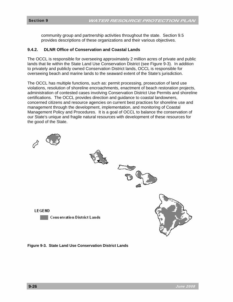
9.4.2. DLNR Office of Conservation and Coastal Lands
The OCCL is responsible for overseeing approximately 2 million acres of private and public lands that lie within the State Land Use Conservation District (see Figure 9-3). In addition to privately and publicly owned Conservation District lands, OCCL is responsible for overseeing beach and marine lands to the seaward extent of the State's jurisdiction. The OCCL has multiple functions, such as: permit processing, prosecution of land use violations, resolution of shoreline encroachments, enactment of beach restoration projects, administration of contested cases involving Conservation District Use Permits and shoreline certifications. The OCCL provides direction and guidance to coastal landowners, concerned citizens and resource agencies on current best practices for shoreline use and management through the development, implementation, and monitoring of Coastal Management Policy and Procedures. It is a goal of OCCL to balance the conservation of our State's unique and fragile natural resources with development of these resources for the good of the State.
Figure 9-3. State Land Use Conservation District Lands

WATER RESOURCE PROTECTION PLAN Section 9
June 2008 9-27
9.4.3. DBEDT Land Use Commission
The LUC’s primary role is to ensure that areas of state concern are addressed and considered in the land use decision-making process. The LUC is administratively attached to DBEDT, and has established four land use districts: Urban District, Rural District, Agricultural District, and Conservation District. The LUC acts on petitions for boundary changes submitted by private landowners, developers and State and county agencies. Decisions on boundary change petitions are guided by a specific set of criteria, which includes preservation or maintenance of important natural systems or habitats. Such values are generally associated with Conservation District lands. The Conservation District is comprised primarily of lands in existing forest and water reserve zones and includes areas necessary for protecting watersheds and water sources, scenic and historic areas, parks, wilderness, open space, recreational areas, habitats of endemic plants, fish and wildlife, and all submerged lands seaward of the shoreline. The Conservation District also includes lands subject to flooding and soil erosion. Conservation Districts are administrated by the BLNR and uses are governed by rules promulgated by the State DLNR.
9.4.4. Department of Health Water Quality Programs
The DOH administers programs that contribute to watershed protection from the water quality perspective. The goals and objectives of the national Clean Water Act and Safe Drinking Water Act, among other federal laws, are embodied in the EPA’s management, regulatory, and permitting programs carried out in Hawaii by the DOH. The DOH Clean Water Branch administers the National Pollutant Discharge Elimination System (NPDES) permits to minimize discharge of pollutants to State waters. The DOH Safe Drinking Water Branch is responsible for protecting drinking water sources (surface water and ground water) from contamination and regulates owners and operators of public water systems. The DOH Wastewater Branch administers water pollution control programs and regulates municipal and private wastewater treatment works, as well as individual wastewater systems. The DOH Environmental Protection Office (EPO) administers the Water Quality Management Program, which includes setting Water Quality Standards and executing the TMDL Process and Continuing Planning Process. For more information on the DOH and water quality management, refer to Section 10 of this document. Most of the EPO’s programs are federally funded. These programs must meet federal Clean Water Act requirements, obtain EPA approval, and employ a watershed-based approach to water quality management. On the EPO’s website, the office acknowledges the need for integrated watershed protection and management: “Our challenges include strengthening the connection between [water quality standards, monitoring and assessment, and long-term planning] efforts and linking them with other government functions and private actions.” This statement echoes the findings of the Watershed Protection Board, with respect to Act 152, which highlighted the need to “integrate all of these [various watershed efforts and programs] into an efficient and focused framework.”

June 2008
WATER RESOURCE PROTECTION PLAN Section 9
9-28
9.4.5. The Hawaii Coastal Zone Management Program
Coastal zone management, or CZM, is about balancing the needs of economic development and conservation of resources in a sustainable manner. The federal Coastal Zone Management Act (CZMA) of 1972 established the voluntary program with a broad framework in order to allow flexibility among the State programs. In 1977, the Hawaii State Legislature enacted the State CZM law (codified in Chapter 205A, Hawaii Revised Statutes (HRS)) to provide a common focus for State and County actions dealing with land and water uses and activities. The Hawaii CZM Program was officially approved in 1978. The Office of Planning (OP) is responsible for the overall administration of the Hawaii CZM Program. As the State’s resource management policy umbrella, the Hawaii CZM Program is the guiding perspective for the design and implementation of allowable uses and activities. The Hawaii State Legislature charged CZM with the responsibility of encouraging agencies to look at resources from a broader ecosystem perspective. The Hawaii CZM Program is undertaking many important initiatives, including but not limited to, the following:
• Coordinate the implementation of the Hawaii Ocean Resources Management Plan (ORMP), which was updated in 2006. The ORMP presents an innovative three-perspective framework, accompanied by concrete management goals and strategic actions for State and County agencies to implement in order to move the State of Hawaii towards comprehensive, integrated management of our coastal resources.
• Assess, consider, and control cumulative and secondary impacts of coastal
growth and development, including integrated planning that builds on and better supports the stewardship efforts of community groups and organizations. The goal is to move the State towards place-, cultural-, and community-based approaches to natural and cultural resource management.
• Obtain final federal approval of the Hawaii Coastal Nonpoint Pollution Control
Program (CNPCP). Section 6217 of the Coastal Zone Act Reauthorization Amendments (CZARA) of 1990 requires each federally-approved CZM program to develop and implement a CNPCP. The Hawaii Program plans to address remaining management measures through an integrated watershed approach by collaborating with all relevant State and County agencies to develop a Watershed Planning Process and Guidance document. The guidance document will serve as an agency and community resource for preparing watershed plans that incorporates the §6217(g) management measures. The watershed planning process will assist in addressing EPA’s 9 key elements for watershed-based plans.
• Reduce hazards to life and property from coastal hazards, including tsunami,
storm waves, stream-flooding erosion, and subsidence.

WATER RESOURCE PROTECTION PLAN Section 9
June 2008 9-29
• Implement CZM Program compliance through Special Management Area (SMA) and Shoreline Setback Areas (SSA), which are designated for more intensive management by the Counties.
The Hawaii CZM Program focuses on complex multi-functional resource management problems, issues, concerns, and opportunities. Section 205A-2, HRS, enumerates the CZM objectives and policies which address recreational resources, historic resources, scenic and open space resources, coastal ecosystems, economic uses, coastal hazards, managing development, public participation, beach protection, and marine resources. Compliance with Chapter 205A, HRS, CZM objectives and policies ensure that appropriately designed developments along coastal areas respect economic, biological, environmental, and cultural values. Within a network of State and County agencies, the program employs a wide variety of regulatory and non-regulatory techniques to address coastal issues and uphold environmental law. Much of CZM’s work is characterized by stewardship; planning; permit administration; education and outreach; multi-functional coordination; policy development and implementation; identification of emerging issues and exploration of solutions; technical assistance to local governments and permit applicants; and assuring State and County compliance with the statutory requirements.
9.5. Watershed Protection and Conservation Partnerships
The establishment of public-private partnership organizations and their ongoing efforts contribute tremendously to watershed protection in Hawaii. These partnerships provide their member entities with specific advantages, including:
• Increased funding base and cooperative-fundraising efforts;
• Decreased duplication of efforts;
• Better application of resources;
• Combined institutional will and momentum;
• Positive public perception of cooperative efforts; and
• Grass roots input and project implementation. Local organizations and partners, including CWRM, are encouraged to continue and expand current efforts and agency participation to promote information sharing, to leverage resources, and to encourage cooperative stewardship.
9.5.1. The Hawaii Association of Watershed Partnerships
In 2003, the Hawaii Association of Watershed Partnerships (HAWP) was established through the signing of a Memorandum of Understanding (MOU) between six existing watershed partnerships. The State of Hawaii also signed the MOU as an individual partner. The parties, through the MOU, established principles and agreed to participate in

June 2008
WATER RESOURCE PROTECTION PLAN Section 9
9-30
cooperative fundraising, building public and political support, and capacity building for island-based mauka watershed partnerships. The HAWP includes nine watershed partnerships on six islands, with representation from more than 50 public and private partners: Figure 9-4 shows the areas included in existing watershed partnerships statewide.
Figure 9-4. Hawaii Watershed Partnerships
Island of Kauai:
• Kauai Watershed Alliance (130,000 acres)
Kamehameha Schools; Princeville Corporation; County of Kauai Department of Water; Kauai Ranch, LLC; Lihue Land Company; McBryde Sugar Company, Ltd.; DLNR; Grove Farm Company, Inc.; Ben A. Dyre Family Limited Partnership
Island of Oahu:
• Koolau Mountain Watershed Partnership (99,000 acres)
Kamehameha Schools; Honolulu BWS; DLNR; Bishop Museum; DHHL; Agribusiness Development Corp.; U.S. Army; Queen Emma Foundation; Manana Valley Farm, LLC; Tiana Partners; Dole Food Co., Inc.; U.S. Fish and Wildlife Service; Hawaii Reserves, Inc.; Kualoa Ranch; Oahu Country Club; The Nature Conservancy; DOH; EPA; U.S. Forest Service; NRCS; USGS

WATER RESOURCE PROTECTION PLAN Section 9
June 2008 9-31
Island of Molokai:
• East Molokai Watershed Partnership (19,000) Kamehameha Schools; Kapualei Ranch; Ke Aupuni Lokahi Enterprise Community Governance Board; DOH; DLNR; Kalaupapa National Historical Park; Maui County; Maui Board of Water Supply; MolokaI-Lanai Soil and Water Conservation District; NRCS; US Fish and Wildlife Service; USGS; EPA; The Nature Conservancy
Island of Lanai:
• Lanaihale Watershed Partnership (20,000 acres)
Castle and Cooke; Maui County Board of Water Supply; Hui Malama Pono O Lanai; DLNR; U.S. Fish and Wildlife Service; NRCS, Molokai-Lanai Soil and Water Conservation District; The Nature Conservancy
Island of Maui: • East Maui Watershed Partnership (100,000 acres)
DLNR; The Nature Conservancy; Maui County Board of Water Supply; Haleakala Ranch Co.; East Maui Irrigation Co., Ltd.; Haleakala National Park; Hana Ranch; County of Maui
• West Maui Mountains Watershed Partnership (53,000 acres)
Maui County Board of Water Supply; Kamehameha Schools; C. Brewer and Co., Ltd.; Amfac/JMB Hawaii, LLC; The Nature Conservancy; Maui Land and Pineapple Co., Inc.; DLNR; County of Maui
• Leeward Haleakala Watershed Restoration Partnership (43,000 acres)
Department of Hawaiian Home Land (DHHL); Estate of James Campbell; Haleakala National Park; Haleakala Ranch; Kaonoulu Ranch; Nuu Mauka Ranch; DLNR; Ulupalakua Ranch; John Zwaanstra
Island of Hawaii: • Olaa Kilauea Partnership (420,000 acres)
Kamehameha Schools; DLNR; Department of Public Safety, Kulani Correctional Facility; U.S. Fish and Wildlife Service; USGS Biological Resources Division; U.S. Forest Service; The Nature Conservancy; National Park Service, Hawaii Volcanoes National Park
• Kohala Mountain Watershed Partnership (32,000 acres)
Parker Ranch, Inc.; Kahua Ranch, Ltd.; Ponoholo Ranch, Ltd.; The Queen Emma Foundation; Kamehameha Schools; Laupahoehoe Nui, LLC; DLNR; DHHL; Hawaii County Department of Water Supply; The Nature Conservancy
Approximately 850,000 acres of forestlands are protected through the HAWP. In addition to continuing the efforts of existing watershed partnerships, the MOU partners also support the formation and development of new partnerships. In DOFAW’s 2006 report to the

June 2008
WATER RESOURCE PROTECTION PLAN Section 9
9-32
Legislature on the NARS and NAPP programs, the development of a new partnership in the Waianae area of Oahu is discussed. Community support was expressed from landowners, land managers, government agencies and interest groups for a watershed partnership focused on the mauka regions of both sides of the Waianae range. There is already a precedent set by the Waianae Kai Community Forest Partnership, which focuses on the Waianae Kai and Makaha Valley Forest Reserves, and includes participation from the Honolulu BWS, the State, and grass-roots community groups active in the Waianae region. A regional partnership that encompasses the entire Waianae range is possible, but some landowners have concerns about land encumbrances. A successful regional partnership will require collaborative efforts from landowners, conservation groups, and community members and must address mauka-to-makai relationships.
9.5.2. Ala Wai Watershed Association
In addition to the mauka watershed partnerships described in Section 9.4.1, other partnership efforts that focus more on water quality, pollution mitigation, and restoration in urban watershed areas and nearshore areas are also underway. Examples of organizations involved in these aspects of watershed protection include the Ala Wai Watershed Association (AWWA) and the Hanalei Watershed Hui (HWH). The Ala Wai Watershed Program is a community-based program spearheaded by the AWWA. The AWWA is a community group funded by the EPA and the State for the purposes of promoting watershed stewardship and improved water quality in the Ala Wai Canal. The watershed includes all of the land area that physically drains into the Ala Wai Canal, the near-shore waters, and the submerged lands extending to and including the reef. The mission of the AWWA is to improve and maintain the water quality in the Ala Wai Canal and its watershed through a community-based effort. Goals include significantly improved water quality, increased community interaction and involvement, additional environmental education for children, and innovative stewardship partnerships between the community, the private sector, and government agencies. The AWWA has engaged in several stream restoration projects within the Ala Wai watershed. Stream restoration is an effective means to improve public stewardship of the watershed, emphasize the environmental and scenic value of streams in urban areas, and help reduce dumping, littering, and waste disposal into storm drains and streams. The AWWA has also been involved with other community-based projects in an effort to improve the water quality in the Ala Wai Canal and its tributary waterways.
9.5.3. Hanalei Watershed Hui
The Hanalei Watershed Hui (HWH) is a 501(c)(3) non-profit environmental organization that “strives to care for the Ahupua'a of Hanalei, Waioli, Waipa, and Waikoko guided by Hawaiian and other principles of sustainability and stewardship, integrity and balance, cooperation and aloha, cultural equity and mutual respect.”15 HWH came about through the designation of the Hanalei River as an American Heritage River (AHR) on July 30, 1998. The American Heritage River Initiative is a federal program that recognizes the important traditional and modern roles of rivers in their surrounding communities, and encourages partnerships to foster environmental protection, historic and cultural preservation, and 15Hanalei Watershed Hui. 2004. Internet, available at: http://www.hanaleiwatershedhui.org.

WATER RESOURCE PROTECTION PLAN Section 9
June 2008 9-33
economic revitalization. The University of Hawaii developed the nomination for the Hanalei River, and the U.S. Forest Service agreed to serve as the "sponsoring federal agency" and provide a "River Navigator" and related expenses for five years, as defined in the AHR initiative. The HWH is funded through grants from the U.S. Forest Service, the EPA, and the National Ocean and Atmospheric Association. The HWH meets quarterly and implements the Hanalei Watershed Action Plan. Objectives, as described on the HWH website, include the achievement of the following:
• Natural river system that supports native ecosystems;
• Identification, conservation, and education of heritage resources;
• A fishable, swimmable, and accessible river;
• Enhanced awareness of local culture and responsible recreation;
• Educational and informational opportunities;
• Preservation of one’s working-rural character;
• Support of taro farming;
• An economy based on diversity, and local, small, shared prosperity; and
• Sharing efforts generously. The HWH’s Action Plan was most recently revised in August 2004, and summarizes the organization’s progress on priority projects. The HWH also prepared a January 2005 Project Update Report for the EPA’s Watershed Initiative Grant. The report includes status information on several projects: residential cesspool demonstration project; beach park wastewater treatment demonstration project; wastewater strategic planning, taro loi demonstration project and study; ungulate fencing demonstration project; biological resources survey and assessment; water quality monitoring; coral recruitment, benthic habitat, and fish surveys; coral disease in Hanalei Bay; oopu (native goby fishery) monitoring; suspended sediment monitoring; and outreach activities. As of 2006, ongoing HWH environmental programs and activities included the following:
• EPA Targeted Watershed Project
• Agriculture Non-Point Source Computer Modeling
• Coral Reef Non-Point Source Local Action Strategy
• Water Quality Investigations – Is it fishable and swimmable?
• Leptospirosis Testing Development

June 2008
WATER RESOURCE PROTECTION PLAN Section 9
9-34
• Waipa Stream and Halulu Fishpond Restoration
• Okolehao Trail Restoration
• TMDL Development for Hanalei Estuary
• Environmental Education Programs Further information on the HWH may be accessed on the organization website at http://www.hanaleiwatershedhui.org.
9.5.4. Conservation Districts
There are approximately 3,000 Conservation Districts nationwide. Conservation Districts, which are also known as “Soil and Water Conservation Districts” and “Resource Conservation Districts,” originated during the Dust Bowl era of the 1930s, after President Roosevelt urged state governors to recommend legislation that would allow the establishment of local, soil Conservation Districts. The mission of Conservation Districts is to coordinate assistance from public and private, local, state and federal sources to develop locally driven solutions to natural resource concerns. According to the National Association of Conservation Districts, the nonprofit organization that represents the 3,000 local Conservation Districts, local residents should make conservation decisions, with technical and funding assistance from federal, state, and local governments and the private sector. Conservation Districts help accomplish the following actions:
• Implement farm conservation practices to keep soil in the fields and out of waterways;
• Conserve and restore wetlands, which purify water and provide habitat for birds,
fish and numerous other animals;
• Protect ground water resources;
• Plant trees and other land cover to hold soil in place, clean the air, provide cover for wildlife, and beautify neighborhoods;
• Help developers and homeowners manage the land in an environmentally
sensitive manner; and
• Reach out to communities and schools to teach the value of natural resources and encourage conservation efforts.
In Hawaii there are 16 Conservation Districts. They strive to coordinate partners and government agencies with identifying and implementing culturally sensitive projects and practices, to assure the protection of Hawaii’s environment.

WATER RESOURCE PROTECTION PLAN Section 9
June 2008 9-35
Current challenges facing Conservation Districts include managing manure and fertilizer to prevent water pollution, restoring wetlands, improving irrigation efficiency and flood protection measures, and addressing urban expansion issues, including the protection of plant and animal habitats and water quality. These challenges are not unique to farmers and ranchers. Although specifics may vary, municipal, state, federal agencies, and conservation groups also deal with the same issues. albeit the specific aspect of the issue varies.
9.6. Gaps In Watershed Protection
The gaps in existing watershed protection programs are primarily communication gaps and disconnects between geographic areas, land managers, land users, water users, water purveyors, regulators, and resource providers. The level of activity observed in watershed protection projects and the high degree of public interest is encouraging, and bodes well for the ultimate preservation and stewardship of watershed resources statewide. However, the multitude of programs and entities involved is dizzying. At some point, the momentum may become overwhelming, and effective communication may not occur between different groups. The cumulative effect will be that watershed protection activities will suffer. It has become increasingly clear, more so since the expiration of Act 152 and the dissolving of the State Watershed Protection Board, that a coordination framework is critical to the long-term success and proliferation of watershed protection and conservation efforts. Such a framework will provide the vehicle by which funding and staffing resources can be most judiciously applied, as well as the forum through which cooperative goals can be established, strategies can be explored, and project implementation can be facilitated.
9.7. Recommendations
The State Water Code states that the CWRM, through the WRPP, shall coordinate programs to conserve, augment, and protect the resource and cooperate with other agencies and entities.16 CWRM establishment of IFS and IIFS and assessments of water availability may be greatly influenced by the activities of the members of the existing watershed partnerships and other government agencies, such as DOH. From a water resource management perspective, watersheds are the beginning of the terrestrial water cycle and the source of all fresh water in Hawaii. From the viewpoint of program implementation and water resource management, CWRM has an important role to play in watershed management in Hawaii. Therefore, the CWRM should directly pursue, or support and cooperate in the implementation of the following recommendations:
• Take a more active role in watershed protection, watershed partnerships, and the watershed partnership association.
• Support DOFAW’s watershed management activities and the division’s
leadership role in watershed management. Focus on the improvement of coordination between DOFAW’s land management programs and CWRM’s water management programs.
16 HRS §174C-31(d)(4) and §174C-5(12).

June 2008
WATER RESOURCE PROTECTION PLAN Section 9
9-36
• Study existing legislative means to protect and preserve our watersheds against contamination and encroachment of intake areas.
• Study existing government and community efforts in watershed management
and protection, and encourage sharing of information and experiences.
• Study other watershed planning approaches and lessons learned, including the EPA’s watershed approach and that of other state governments.
• Pursue appropriate funding to support watershed protection programs and
objectives to protect water resources.
• Encourage the collaboration of federal, State, and county agencies with existing watershed partnerships and Conservation Districts to map the relationships between land management programs, land use regulations, economic and agricultural issues, and water quality and resource protection programs.
• Improve communication and encourage dialogue between watershed interests
to result in the development of common goals and an integrated watershed management framework. A successful framework will acknowledge and build upon existing programs and organizations to maximize funding, staff, and volunteer resources through watershed-scale management and protection programs.
• Develop innovative public outreach methods and encourage communication
between watershed entities. The development of a website for devoted to Hawaii watershed projects, organized by geographic location, should facilitate this coordination.