Embed Size (px)
Citation preview
i
j
s E5WD1
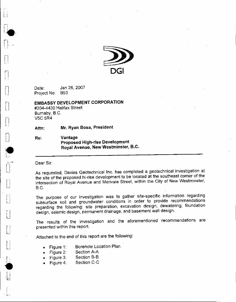
N Date Jan 26 2007
t Project No B53
EMBASSY DEVELOPMENT CORPORATION
2044430 Halifax Street
Burnaby BC
V5C 5R4
Attn Mr Ryan Bosa President
iRe Vantage
Proposed Highrise DevelopmentF Royal Avenue New Westminster BC
Dear Sir
1As requested Davies Geotechnical Inc has completed a geotechnical investigation at
the site of the proposed hirise development to be located at the southeast corner of the
I Jintersection of Royal Avenue and Merivale Street within the City of New Westminster
t B C
j The purpose of our investigation was to gather sitespecific information regardingU subsurface soil and groundwater conditions in order to provide recommendations
regarding the following site preparation excavation design dewatering foundation
1 design seismic design permanent drainage and basement wall design
JThe results of the investigation and the aforementioned recommendations are
presented within this report
Attached to the end of this report are the followingr
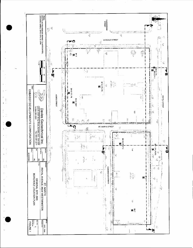
Figure 1 Borehole Location Plan
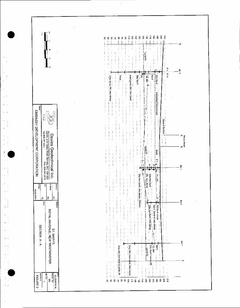
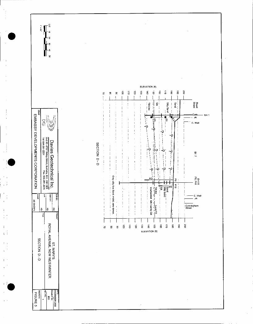
Figure 2 Section AA
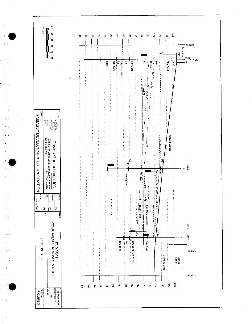
I j Figure 3 Section BB
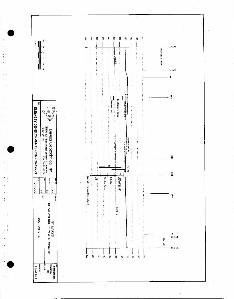
Figure 4 Section CC
ff5
r
i
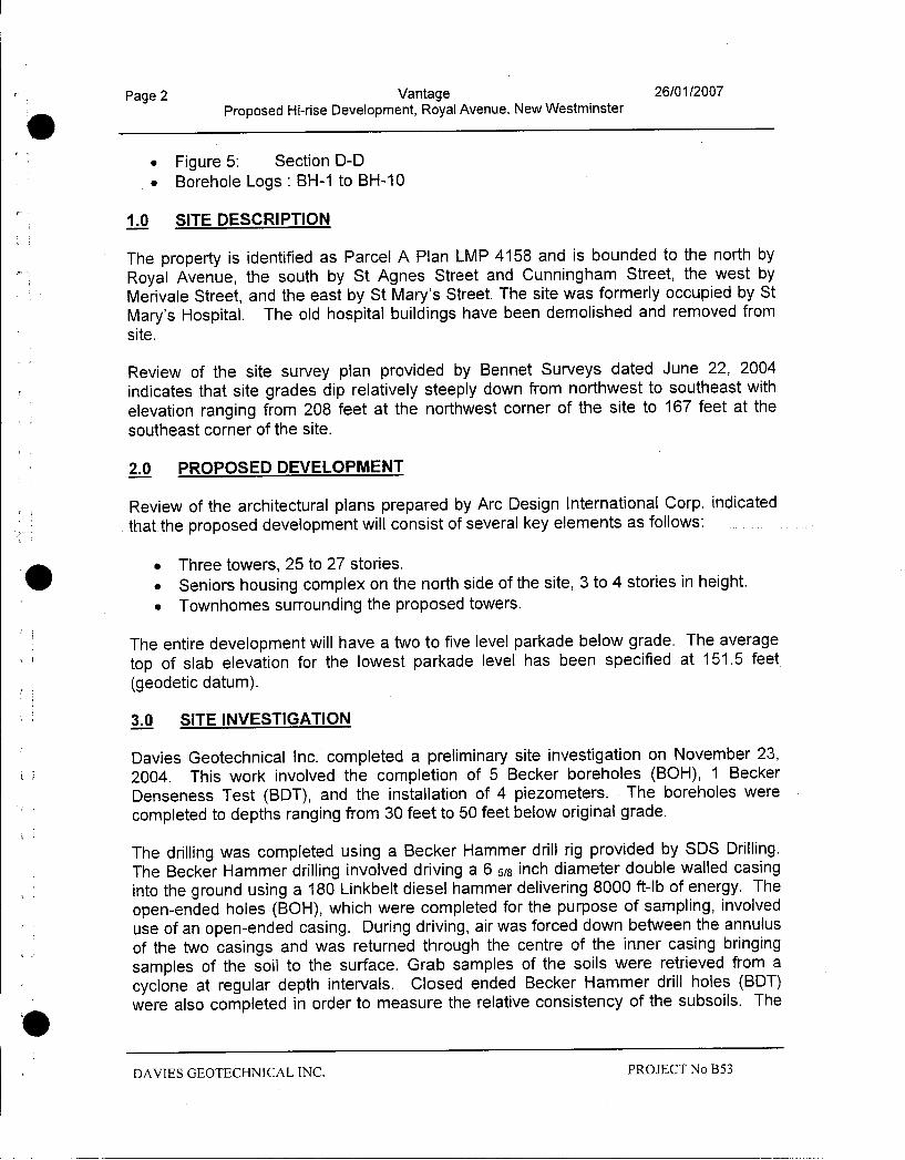
Page 2 Vantage 26012007
Proposed Hirise Development Royal Avenue New Westminster
Figure 5 Section DD
Borehole Logs BH1 to BH10
10 SITE DESCRIPTION
The property is identified as Parcel A Plan LMP 4158 and is bounded to the north by
Royal Avenue the south by St Agnes Street and Cunningham Street the west byMerivale Street and the east by St Marys Street The site was formerly occupied by St
Marys Hospital The old hospital buildings have been demolished and removed from
site
Review of the site survey plan provided by Bennet Surveys dated June 22 2004
indicates that site grades dip relatively steeply down from northwest to southeast with
elevation ranging from 208 feet at the northwest corner of the site to 167 feet at the
southeast corner of the site
20 PROPOSED DEVELOPMENT
Review of the architectural plans prepared by Arc Design International Corp indicated
that the proposed development will consist of several key elements as follows
Three towers 25 to 27 stories
Seniors housingcomplex on the north side of the site 3 to 4 stories in heightTownhomes surrounding the proposed towers
The entire development will have a two to five level parkade below grade The average
top of slab elevation for the lowest parkade level has been specified at 1515 feet
geodetic datum
30 SITE INVESTIGATION
Davies Geotechnical Inc completed a preliminary site investigation on November 23
2004 This work involved the completion of 5 Becker boreholes BOH 1 Becker
Denseness Test BDT and the installation of 4 piezometers The boreholes were
completed to depths ranging from 30 feet to 50 feet below original grade
The drilling was completed using a Becker Hammer drill rig provided by SIDS DrillingThe Becker Hammer drilling involved driving a 6 58 inch diameter double walled casinginto the ground using a 180 Linkbelt diesel hammer delivering 8000 ftlb of energy The
openended holes BOH which were completed for the purpose of sampling involved
use of an openended casing During driving air was forced down between the annulus
of the two casings and was returned through the centre of the inner casing bringing
samples of the soil to the surface Grab samples of the soils were retrieved from a
cyclone at regular depth intervals Closed ended Becker Hammer drill holes BDTwere also completed in order to measure the relative consistency of the subsoils The
DAVIES GEOTECHNICAL INC PROJECT No B53
Page 3 Vantage 26012007
Proposed Hirise Development Royal Avenue New Westminster
number of blows required to drive the closed ended casing each foot are considered
BDT N values and are comparable to SPT N60 values up to depths of 50 feet below
grade
A second stage of investigation was completed in November of 2006 and involved the
completion of 5 boreholes to depths ranging from 60 feet to 146 feet below existing
grade These boreholes are identified as BH6 to BH10 on the site plan attached to this
report Standpipe piezometers were installed within the open boreholes for BH6 BH8
BH9 and BH10 at varying depths and elevations The details of the piezometersinstallations are illustrated on the soil logs attached to this report Boreholes BH6 to
BH10 were completed using a Sonic Drill rig which enabled the recover of a
continuous core of the soils encountered at the each borehole location to be recovered
Standard penetration test SPT was conducted at regular depth intervals 5 feet on
average within boreholes BH6 to BH10
The approximate locations of all boreholes are shown on Figure 1 Site Plan attached
to this report
All test holes were logged and sampled by qualified personnel from Davies
Geotechnical Inc Representative samples of the subsoils encountered were returned to
our laboratory for further classification and moisture content testing
Summaries of the soil conditions encountered at each borehole location as well as the
results of SPT testing and laboratory testing the details regarding piezometers
installations and measured water levels are shown on the borehole logs attached to the
end of this report
40 RESULTS
41 Site Geology
Review of the Geologic Survey of Canada map 1484 A indicates that the site is located
in an area underlain by Vashon drift and Capilano sediments VC which are glacialdrift including lodgment and minor flow till lenses and interbeds of glaciofluvial sands
These soils are typically overconsolidated and consequently can be characterized as
having high strength and being relatively incompressible
42 Soil Conditions
Summaries of the subsurface conditions at each borehole location are shown on the
borehole logs attached to the end of this report Review of the borehole logs indicates
that subsurface conditions are relatively consistent across the site and conform to the
known geology of the area and can be summarized as follows
DAVIES GEOTECHNICAL INC PROJECT No B53
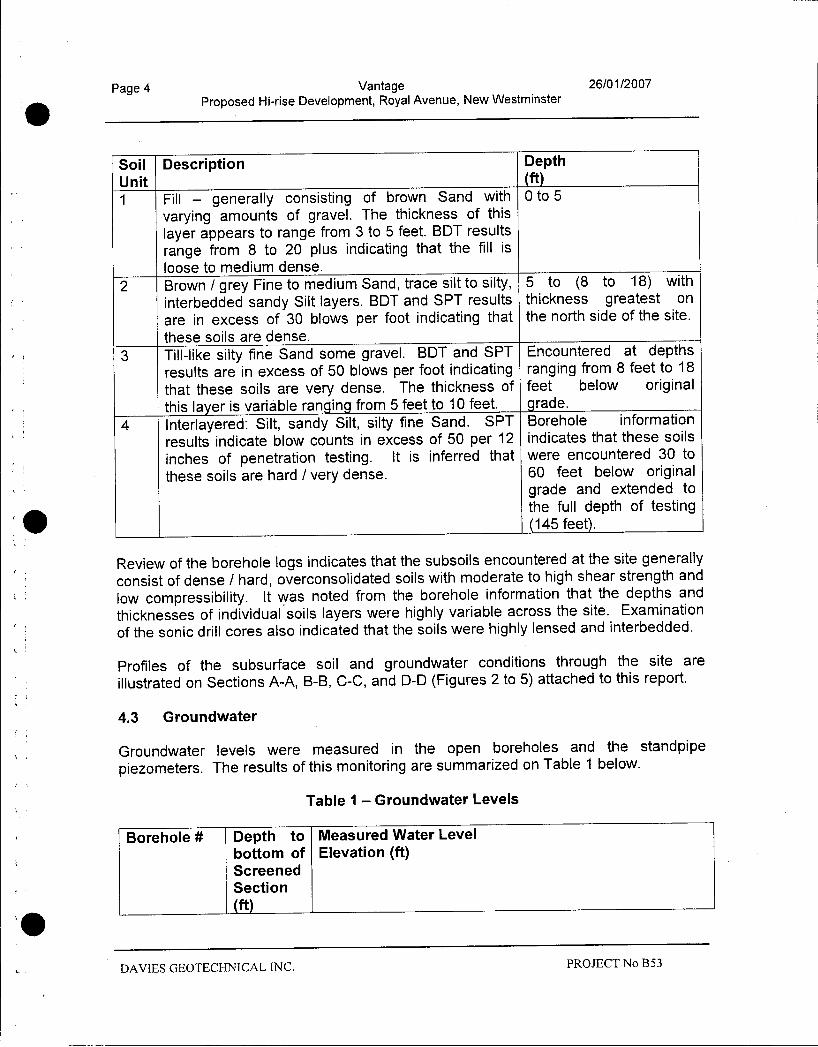
Page 4 Vantage 26012007
Proposed Hirise Development Royal Avenue New Westminster
Soil Description DepthUnit ft1 Fill generally consisting of brown Sand with 0 to 5
varying amounts of gravel The thickness of this
layer appears to range from 3 to 5 feet BDT results
range from 8 to 20 plus indicating that the fill is
loose to medium dense
2 Brown grey Fine to medium Sand trace silt to silty 5 to 8 to 18 with
interbedded sandy Silt layers BDT and SPT results thickness greatest on
are in excess of 30 blows per foot indicating that the north side of the site
these soils are dense
3 Tilllike silty fine Sand some gravel BDT and SPT Encountered at depthsresults are in excess of 50 blows per foot indicating ranging from 8 feet to 18
that these soils are very dense The thickness of feet below originalthis layer is variable ranging from 5 feet to 10 feet grade
4 Interlayered Silt sandy Silt silty fine Sand SPT Borehole information
results indicate blow counts in excess of 50 per 12 indicates that these soils
inches of penetration testing It is inferred that were encountered 30 to
these soils are hard very dense 60 feet below originalgrade and extended to
the full depth of testing145 feet
Review of the borehole logs indicates that the subsoils encountered at the site generally
consist of dense hard overconsolidated soils with moderate to high shear strength and
low compressibility It was noted from the borehole information that the depths and
thicknesses of individual soils layers were highly variable across the site Examination
of the sonic drill cores also indicated that the soils were highly lensed and interbedded
i
Profiles of the subsurface soil and groundwater conditions through the site are
illustrated on Sections AA BB CC and DD Figures 2 to 5 attached to this report
43 Groundwater
Groundwater levels were measured in the open boreholes and the standpipe
piezometers The results of this monitoring are summarized on Table 1 below
Table 1 Groundwater Levels
Borehole Depth to Measured Water Level
bottom of Elevation ftScreenedSection
ft
DAVIES GEOTECHNICAL INC PROJECT No B53
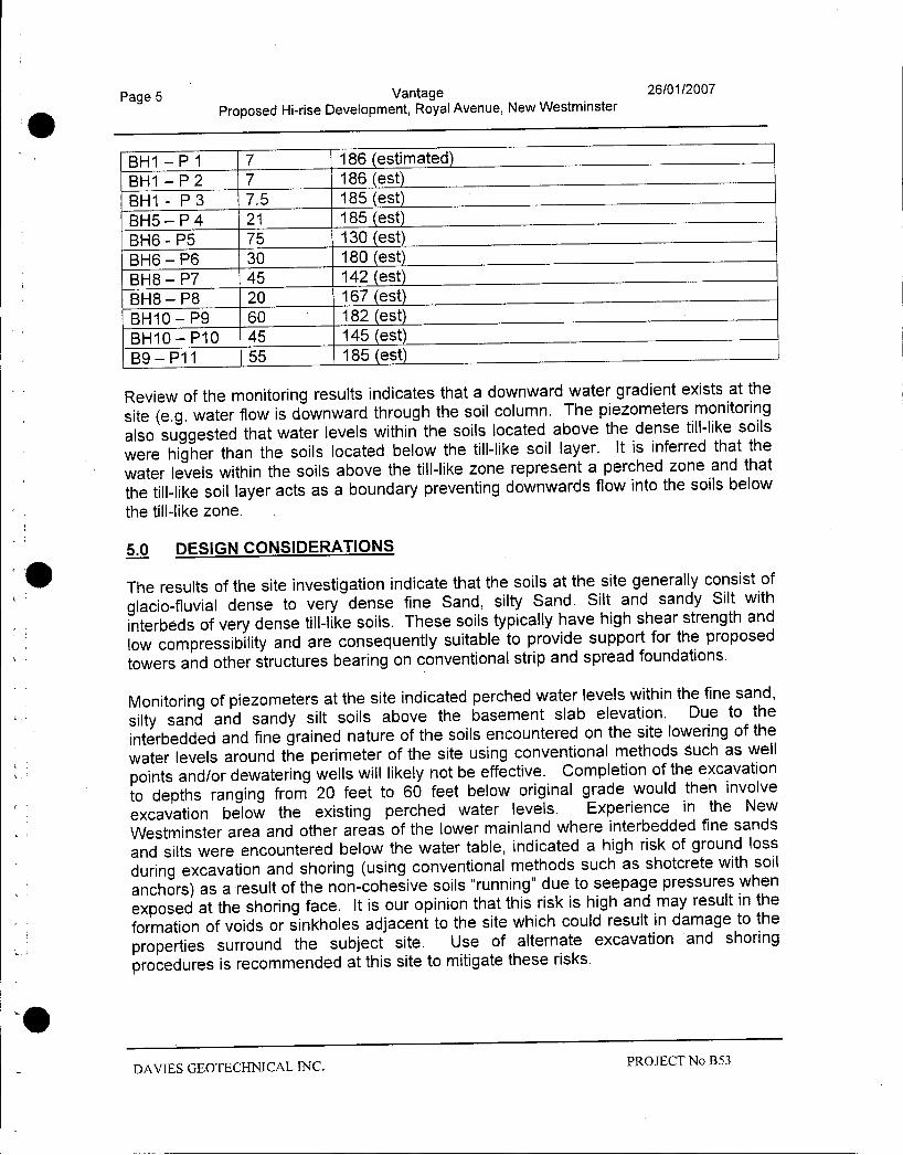
Page 5 Vantage 26012007
Proposed Hirise Development Royal Avenue New Westminster
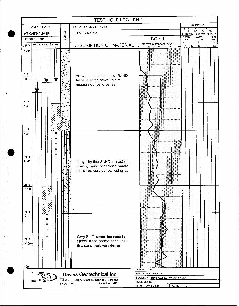
BH1 P 1 7 186 estimated
BH1 P 2 7 186 est
BH1 P 3 75 185 est
13115P 4 21 185 est
BH6 P5 75 130 est
BH6 P6 30 180 est
BH8 P7 45 142 est
BH8 P8 20 167 est
BH10 P9 60 182 est
BH 10 P10 45 145 est
B9 P11 55 185 est
Review of the monitoring results indicates that a downward water gradient exists at the
site eg water flow is downward through the soil column The piezometers monitoring
also suggested that water levels within the soils located above the dense tilllike soils
were higher than the soils located below the tilllike soil layer It is inferred that the
water levels within the soils above the tilllike zone represent a perched zone and that
the tilllike soil layer acts as a boundary preventing downwards flow into the soils below
the tilllike zone
50 DESIGN CONSIDERATIONS
The results of the site investigation indicate that the soils at the site generally consist of
glaciofluvial dense to very dense fine Sand silty Sand Silt and sandy Silt with
interbeds of very dense tilllike soils These soils typically have high shear strength and
low compressibility and are consequently suitable to provide support for the proposed
towers and other structures bearing on conventional strip and spread foundations
Monitoring of piezometers at the site indicated perched water levels within the fine sand
silty sand and sandy silt soils above the basement slab elevation Due to the
interbedded and fine grained nature of the soils encountered on the site lowering of the
water levels around the perimeter of the site using conventional methods such as well
points andor dewatering wells will likely not be effective Completion of the excavation
to depths ranging from 20 feet to 60 feet below original grade would then involve
excavation below the existing perched water levels Experience in the New
Westminster area and other areas of the lower mainland where interbedded fine sands
and silts were encountered below the water table indicated a high risk of ground loss
during excavation and shoring using conventional methods such as shotcrete with soil
anchors as a result of the noncohesive soils running due to seepage pressures when
exposed at the shoring face It is our opinion that this risk is high and may result in the
formation of voids or sinkholes adjacent to the site which could result in damage to the
properties surround the subject site Use of alternate excavation and shoring
procedures is recommended at this site to mitigate these risks
DAVIES GEOTECHNICAL INC PROJECT No B53
Page 6 Vantage 26012007
Proposed Hirise Development Royal Avenue New Westminster
60 RECOMMENDATIONS
61 Excavation and Shoring
The average top of slab elevation for the lowest parkade slab has been established by
the architect at elevation 151 feet geodetic datum Existing grades around the
perimeter of the site are highly variable ranging from 165 feet geodetic datum to 210
feet geodetic datum The resulting bulk excavation depth will also be variable ranging
from approximately 20 feet along the southern boundary to a maximum of
approximately 60 feet along the northern boundary
Use of conventional shoring may be feasible within the soils located above the water
table However in view of the high water table potential for ground loss and high risk
of damaging adjacent properties using conventional excavation and shoring methods
we recommend that groundwater flows be cut off around the perimeter by the creation
of a continuous cutoff wall using soil mixing jet grouting or other suitable techniques
Design of this cutoff system should consider the density and grain size distribution of
the soils with consideration of methods to address potential construction difficulties
associated with drilling and grouting through very dense tilllike soils which may contain
boulders
The shoring system will likely consist of vertical structural elements such as pipe piles or
HPiles installed within the soil mix or jet grout cutoff wall tied back with soil anchors
The shoring system will have to be designed for the applicable soil and surcharge
pressures as well as full hydrostatic pressures The structural components of the
shoring system should be designed or reviewed by a structural engineer with
experience in shoring design in the Lower Mainland
Use of the jet grout or soil mix cutoff system will require encroachment beyond the
perimeter of the building of approximately 5 feet 3 feet to allow the thickness of the cut
off wall and 2 feet of working space between the shoring face and the basement wall
In the event that the upper portion of the excavation can be shored using conventional
methods above the water table additional encroachment beyond the building will be
required
It is recommended that prior to commencing with excavation and shoring that a baseline
survey and monitoring program be established for the areas adjacent to the subject
property We also recommend the installation of inclinometers around the perimeter of
the site particularly the north side to monitor ground movements as the excavation
proceeds
A detailed excavation and shoring plan and specification should be prepared by Davies
Geotechnical Inc
DAVIES GEOTECHNICAL INC PROJECT No B53
I
Page 7 Vantage 26012007
Proposed Hirise Development Royal Avenue New Westminster
62 Temporary Dewatering
We anticipate that the cutoff system as proposed will be effective in cutting off
horizontal groundwater flows and limiting upwards flow from the base of the excavation
so that temporary dewatering could be handled using sumppumps located at the base
of the excavation
63 Foundation Design
The borehole information indicates that soils encountered at the proposed design
elevation may be variable consisting of dense hard Silt sandy Silt and silty Sand For
the purposes of preliminary foundation design the following allowable bearing pressures
may be used
Pad footings Qa 6000 psfDLLLStrip footings Qa 4000 psfDLLL
Individual footing settlements are expected to be less than 1 inch Footing settlements
may be larger in the event that adjacent footings are located within the zone of influence
of adjacent footings A detailed review of footing settlements and bearing pressures
should be completed by the geotechnical engineer once a detailed foundation plan is
available
Higher bearing pressures may be acceptable for specific foundations subject to a review
by the geotechnical engineer
Footings should be founded a minimum of 18 inches below top of slab or exterior grade
elevation
Footings founded at differing elevations should be founded to that the slope of the line
drawn from the underside of one footing to the adjacent footing is at 2 horizontal to 1
vertical or flatter
Soils encountered at the design elevation are expected to consist of fine grained soils
which are sensitive to disturbance when exposed to water or construction traffic
Consequently we recommend that footings be excavated and blinded with a skim coat
of lean concrete on the same day Prior to the placement of the skim coat all footing
subgrades should be inspected and approved in writing by the geotechnical engineer
64 Seismic Design Parameters
The site is located in a seismically active area where the effects of earthquake loading
must be considered in the design of the proposed buildings
Based upon NBCC 2005 and review of the borehole information the site is classified
as Site Class C The soils associated with this site class consist of very dense soils
DAVIES GEOTECHNICAL INC PROJECT No B53
Page 8 Vantage 26012007
Proposed Hirise Development Royal Avenue New Westminster
with N60 values greater than 50 and undrained shear strengths greater than 2000 psf
A fifty percent increase in allowable bearing pressure for seismic load conditions is
considered acceptable associated with a reduction in safety factor on the ultimate
bearing pressure
65 Permanent Drainage
Use of a permanent drainage system will be required to control water levels below slab
elevation We anticipate that this system will comprise of a network of sub floor drains
connected to a pumped sump or suitable gravity discharge The drains should consist
of perforated plastic piping surrounded by drain gravel and wrapped with filter fabric
installed within gravel filled trenches with invert elevation at least 12 inches below the
underside of slab
A 12 inch thick drainage blanket consisting of 12 to 14 inch clear crushed gravel should
be placed immediately below the underside of slab to act as a drainage layer and to
allow water to flow laterally to the subfloor drainage system
The details of the subfloor drain system should be reviewed by the geotechnical
engineer once the bulk excavation is completed and a more accurate assessment of
groundwater flows can be completed
66 Basement Wall Design
The basement walls will have to be designed to resist the applicable lateral pressures
associated with earth pressures compaction loads surface surcharges seismic loads
and hydrostatic pressures if necessary The details regarding the shoring system and
drainage have not been finalized and therefore Davies Geotechnical Inc will provide
detailed recommendations regarding lateral earth pressures once these designelements are completed
In the event that the shoring system is designed to cutoff the groundwater flows the
perimeter basement walls will have to be designed to accommodate hydrostatic
pressure However the groundwater will be retained by the shoring system and will not
be in direct contact with the basement walls and therefore we do not anticipate the need
to waterproof or tank the exterior of the basement walls We recommend the
installation of a perforated drain and drain chimney to capture any water that seeps
through the cutoff wall
70 ADDITIONAL WORK
Prior to tendering the project we recommend that the geotechnical engineer review the
foundation design including a review of potential settlements
A review of the proposed subfloor drain system should also be conducted
PROJECT No B53DAMES GEOTECHNICAL INC
I
Page 9 Vantage 26012007
Proposed Hirise Development Royal Avenue New Westminster
A detailed excavation and shoring design and specification should be prepared by
Davies Geotechnical Inc
Review and inspection will be required by the geotechnical engineer during the
construction process These inspections will include but not be limited to the following
1 Inspection of the installation of the grout cutoff wall and piling
2 Inspection and testing of the soil anchors
3 Monitoring of inclinometers and review of the survey results from the movement
monitoring program4 Inspection of all footing areas prior to skim coating or placing concrete
5 Inspection of the installation of the subfloor drain system and subfloor drainage
layer6 Inspection of the placement of perimeter drainage and backfill
80 CLOSURE
Davies Geotechnical Inc has completed a geotechnical investigation at the site of the
proposed Vantage hirise development to be located at Royal Avenue in New
Westminster BC
The results of the preliminary indicate that dense soils were encountered close to
existing grade across the entire site Consequently the proposed hirise towers and
other structures can be founded on conventional strip and spread foundations
Periodic reviews of the site conditions and construction should be completed by the
geotechnical engineer in order to confirm that the site conditions are compatible with the
design and the work is completed in general conformance with the project
specifications
The information provided in this report is intended for the purposes of preliminary design
and should not be incorporated directly into specifications without approval by Davies
Geotechnical Inc
We trust that the information provided within this report meets your requirements at this
time If you have any questions or require additional information please do not hesitate
to contact the undersigned at6042912201
4
DAVIES GEOTECHNICAL INC PROJECT No B53
Page 10 Vantage 26012007
Proposed Hirise Development Royal Avenue New Westminster
I
Yours truly
0 111 IV
rip
P
DAVIES GEOTECHNICAL INC
P
k
DAVIES GEOTECHNICAL INC PROJECT No B53
zmz
m Im n
41 y2ov mz rF
0
om I
K
mzz
N A MERIVALE STREETN r I
O
n I1
r
IIo
i 1
dtiI
III
m j mI Jm 1
D I p
KZ I j m
m
o
A 1 I AI
Dm
Im
mI o
y m
O N fn co I II I
1oND
z jj CD
LST MARYS STREET
0 CD
Tc 3
O k G 3
mP I
Z m C7
1
A 5 I
II o
I IIz o o v
i
z
pr
n
XG y 1
S m IlOmzCmj
o m1
DC cn
4
m
O mzz j1
Is I 1
zmo
I I I
oz m
1 m
a m m ao o n cn m m co o0 0 0 0 0 0 0 o a o Ao 0 0 0 0 0 0 0
r
I
m
V I Nt
gm A W
Now
INN mFl il
1
m N
II
II
I
QI I I
I
coI
I aCt
0 1
mI m
I m
fm o f I
o
z
INO
o
T
O x P I i
Z rv2 1i N yIT
a 1IL
1I 1f II m
toIit
I
1I
O O O I1
Q N
e C1 m 11 n N T
m I Ir n mO
Irv mn
m
1 I
z zzdl G
m m rtezC0 mlm
m
Oz
i
Dm D 111 m
D m c InA Z i7
Imo
11 c o om
mw
zo o 0 0 0 0 0 0 o a o 0 0 0 0 0 0 0 0
m AN
Of V M O N W A U O OJ O OO O O O O O O O O O O O O O O O
C Curb
A
mBH 9
m m m tii m m n in I N nC Curb
n
II I n 1
m oNi ami I m l I
I I 1 Cai I I I
I I I
1N I I I
I I II I I
I I II I I
1 1
n f I I i1 I
1
W I I
r Cn
1
I I 1 I I
ii 1 I I
I I Im
aA p u I
m
CD FD
m 11
UN
I N@ I Im
U0
Ib I I
1
I
mm
i II
3x
m
T Q I
o n m I IIII
m N 71
m 1 I 1 mlz
iDA 1 1
1
Ir
1 co1ITz o vom w l
rI I
II
I al i
D WI
Vry
1i I4V I
VG I j m m
m
m zmc cn
fn 7qO zz rn y a
m
C Curb
co mcn may
z 1 d
mC Curb
W 01 N O O N W A N dI V O O
O O O O O O O O O O O O O O O O
T c on
m
m m
m pW
O N W A N O V O m O
O O O O O O O O O O O O
o C Curb
o Am
p
o
m
m
I
C Curb
FE
I cor x
113
ai ubQ1
im N
D
cl I I
O
m I I
Orv II IDa N cn
o
m1 Ia
U I
A CDto NC7 m CCDO
and coo x
O
7 x
O o m Im
co2
71m
N m m I mN N
m
2 O o Oi
n I
3o m
O
r
t C IN
Nmm z
n cNm i
zZ m D
cnFL
7 m C Curb
cf
Zm
N C Curbim
N
O O O O O O O O O O O
T c o v
im
om
n
c u om m
mm
A
i
I
ELEVATION ft
N
O O O O O O O O O O O O O O
i N N m n oc cm c
Qm
a
m aH t
D i a i Nm
C Wall
i
vI i
Ir a MO N N M I I i r
m O IVZ z
cfN CD v
r
m D
Qa
n c l is
v m
z a I g I1 N rnM o
U
L gm
C Wall
o n I a
Cunningham
z o 0 0Street
Ipn
O O O O O O O O O O O O O O
D ELEVATION ft
D
Mmzc cf
E i zz mDv g
Mto
zim
Tl Q O m
G7 0 mC u o m
A
M gcn
i
TEST HOLE LOG BH1
SAMPLE DATA ELEV COLLAR 194 ftCOHESION KPa
100 200 300 400
WEIGHT HAMMER m ELEV GROUND 9FIELOVANE ALABVANE UNCONF
WATERHEIGHT DROP BOH1 PLMITIC CONTENT LLIIIT
X GX
DEPTH PEIZO PEIZO PEIZO DESCRIPTION OF MATERIAL PENETRATION RESISTANCE BLOWSIFT
1 2 3 0 25 50 75 1 10 30 50 70 90
w
5 ftBrown medium to coarse SAND
15mtrace to some gravel moistmedium dense to dense
loft
7130m i
v
15 ft
45m
20 ft
som Grey silty fine SAND occasional
gravel moist occasional sandysilt lense very dense wet @ 23
25 ft
30 ft
35 ft Grey SILT some fine sand to
106msandy trace coarse sand trace
fine sand wet very dense
I
40ftJOB No 853
Davies Geotechnical Inc PROJECT ST MARYS
LOCATION Royal Avenue New WestminsterUnit 3 5707 Sidley Street Burnaby BC V5H 5E6
Tel 6042912201 Fax 6042912274HOLE No BH1
DATE NOV 25 2004 PLATE 1 of 2
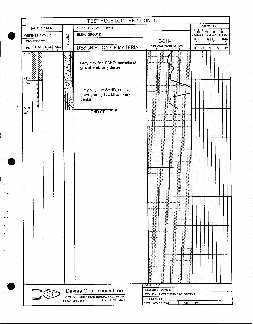
TEST HOLE LOG BH1 CONTD
SAMPLE DATA ELEV COLLAR 194 ftCOHESION KPa
WEIGHT HAMMER m ELEV GROUND RELD100VANE 20 LAIIVANNE UNCONF
WATER
NTENT LLIMITHEIGHT DROP BOH1 PLIMITC CON x o x
25
TION RE5150TANCEBL0551Fi 10 10 30 50 70 90DEPTH PEzo PE2zo PE3zo DESCRIPTION OF MATERIAL 0
PENETRA
ftm
Grey silty fine SAND occasional
gravel wet very dense
45 ft
15m
Grey silty fine SAND some
gravel wet TILLLIKE very
dense
50 ft
3Om END OF HOLE
I
i II
JOB No B53
Davies Geotechnical Inc PROJECT ST MARYS
LOCATION Royal Avenue New Westminster
Unit 3 5707 Sidley Street Burnaby BC V5H 5E6
Tel 6042912201 Fax 6042912274 HOLE No BH1
DATE NOV 25 2004 PLATE 2 of 2
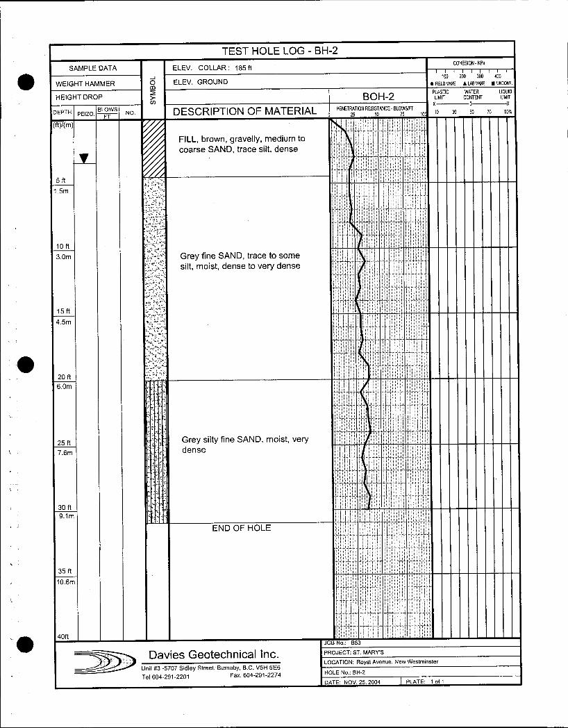
TEST HOLE LOG BH2
SAMPLE DATA ELEV COLLAR 185 ftCOHESION IPa
100 200 300 400
WEIGHT HAMMER m ELEV GROUND FIELD VANE LAB VANE UNCONF
HEIGHT DROP BOH2PMITIC CONTENT LIIMIT
X o x
DEPTH PEIZOBLOWS
NO DESCRIPTION OF MATERIAL 0
PENETRATIONRESIANCE BLOSSFf 10 10 30 50 10 90FT 25 so
FILL brown gravelly medium to Icoarse SAND trace silt dense i
515mf
loft I
30m Grey fine SAND trace to some
silt moist dense to very dense I
15ft
45m
i
20 ft
60nnT
25 ft Grey silty fine SAND moist very
dense
30 ft
91m
END OF HOLE
35 ft
106m
wT
40ftJOB No B53
DDavles Geotechnlcal Inc PROJECT ST MARYS
LOCATION Royal Avenue New Westminster
Unit 3 5707 Sidley Street Burnaby BC V5H 5E6
Tel 6042912201 Fax 6042912274HOLE No BH2
DATE NOV 25 2004 PLATE 1 of 1
i
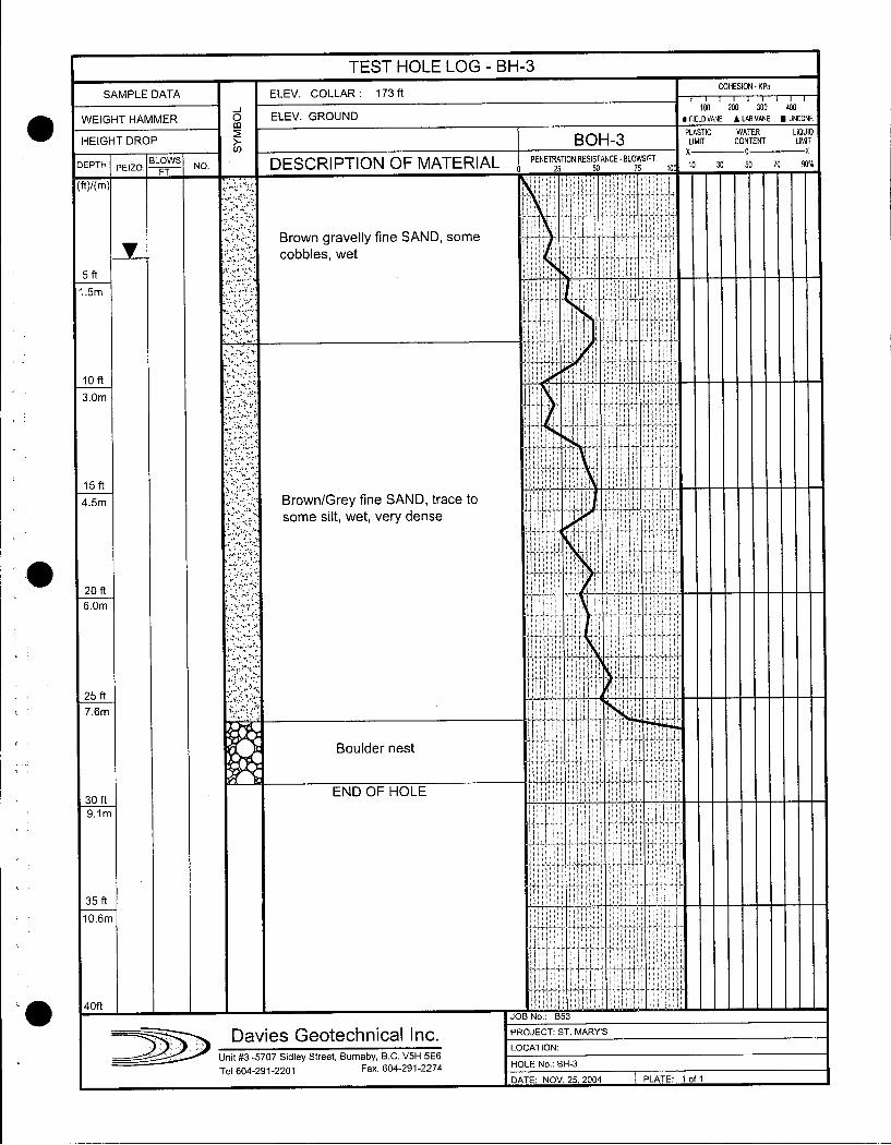
TEST HOLE LOG BH3
SAMPLE DATA ELEV COLLAR 173 ftCOHESION KPa
100 200 300 400
WEIGHT HAMMER 00 ELEV GROUND FIELOVANE ALABVANE UNCONF
HEIGHT DROP BOH3PLASTIC
CONTENT LLIMITx 0 x
DEPTH PEIZOBLOWS NO DESCRIPTION OF MATERIAL 0
PENETRATION RESISOTANCEBLOWSFT 10 10 30 50 70 90FT 1 25 5
ftm i
A Brown gravelly fine SAND some
cobbles wet
5 ft
15m
loft
30m
15 ft r45m BrownGrey fine SAND trace to
some silt wet very dense
20 ft
60m t tf
I4
125 ft
76m
Boulder nest
30 ftEND OF HOLE
91 m
35 ft
106m
I i40ftJOB No B53
Davies G20t2ChC11Cal Inc PROJECT ST MARYS
LOCATION
Unit 3 5707 Sidley Street Burnaby BC V5H 5E6
Tel 6042912201 Fax 6042912274HOLE No BH3
DATE NOV 25 2004 PLATE 1 of 1
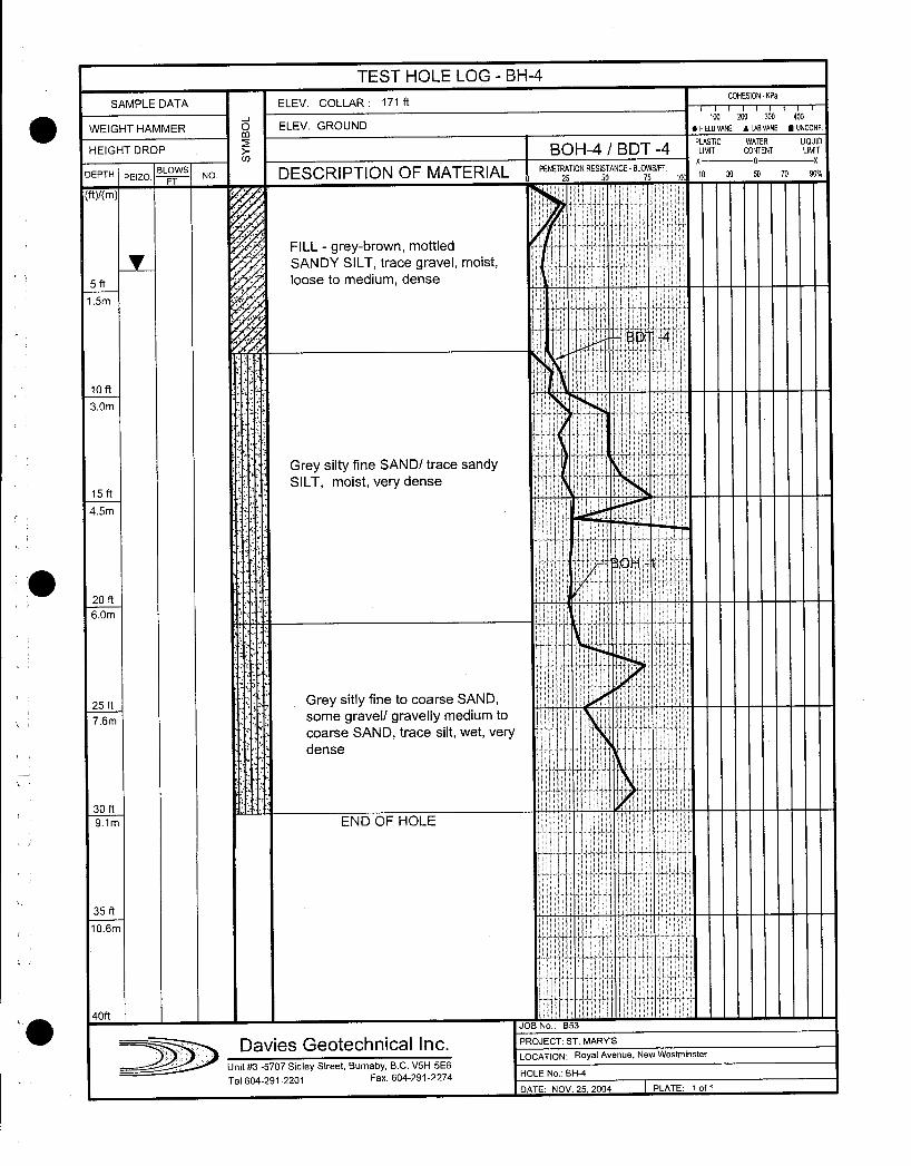
TEST HOLE LOG BH4
SAMPLE DATA ELEV COLLAR 171 ftCOHESION KPa
J 100 200 300 400
WEIGHT HAMMER m ELEV GROUND FIELDVANE AM VANE UNCONF
WATER
HEIGHT DROP BOH4 BDT 4P
MITC CONTENT LLIIMITU x o x
DEPTH PEIZOBLOWS
NO DESCRIPTION OF MATERIAL PENETRATION RESI50TANCEBLOSSFT 10 30 50 70 90h1 25
ftm I 1
FILL greybrown mottled
SANDY SILT trace gravel moist
5 ft loose to medium dense
15m
BD4
loft
30nn
Grey silty fine SAND trace sandySILT moist verydense
15 ft
45m
OH
20 ft
6Om
25 ft Grey sitly fine to coarse SAND
76m some gravel gravelly medium to
coarse SAND trace silt wet very
dense
30 ft
91m END OF HOLE
35 ft
106m
40ftJOB No 653
ST MARYSDaVI@S GeoteChnlCal Inc N Royal AvenueRoyal AveJ LOCATInue New Westminster
Unit 3 5707 Sidley Street Burnaby BC V5H 5E6SH4
Tel 6042912201 Fax 6042912274HOLE No
DATE NOV 2525 2004 PLATE 1 of 1
I
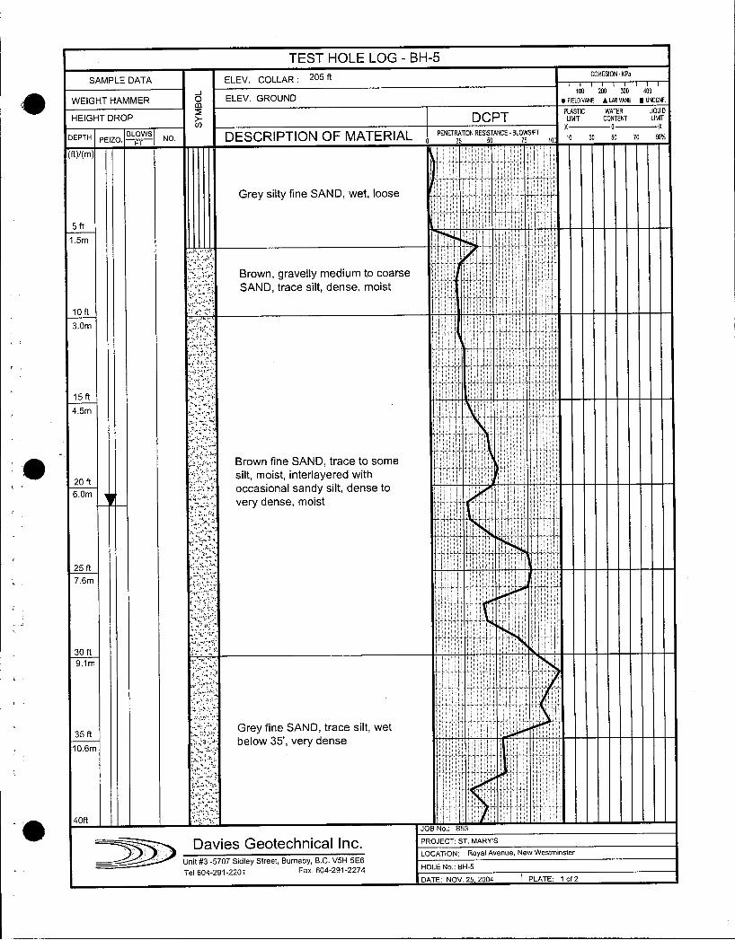
TEST HOLE LOG BH5
SAMPLE DATA ELEV COLLAR 205 ftCOHESION KPa
J 100 200 300 400
WEIGHT HAMMERm
ELEV GROUND FIELD VANE 1LAB VANE UNCONF
HEIGHT DROP DCPT PMR CONTENTWATER LIQIUID
X o z
DEPTH PEIZO IBLOWS
NO DESCRIPTION OF MATERIAL 0 PENETRA25TIONRESISTANCE
BL05SFf 10 10 30 50 70 90
ftm
Grey silty fine SAND wet loose
5ft
15m
Brown gravelly medium to coarse I
SAND trace silt dense moist
loft
3Om
15 ft
45nn
Brown fine SAND trace to some f
20ftr silt moist interlayered with t
occasional sandy silt dense to
very dense moist
25 ft
76nn
30 ft
91 m
35 ft Grey fine SAND trace silt wet
below 35 very dense106m
40ft I
JOB No B53
Davies Geotechnical Inc PROJECT ST MARYS
J LOCATION Royal Avenue New Westminster
Unit 3 5707 Sidley Street Burnaby BC V511 5E6
Tel 6042912201 Fax 6042912274HOLE No BH5
DATE NOV 25 2004 PLATE 1 of 2
i
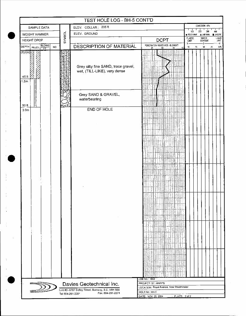
TEST HOLE LOG BH5 CONTD
ftCOHESION KPa
SAMPLE DATA ELEV COLLAR 205
too 200 900 400
WEIGHT HAMMER Oco ELEV GROUND FIELD VANE ALAB VANE UNCONF
PLASTIC WATER LIQUIDHEIGHT DROP DCPT LIMIT CONTENT LIMIT
DEPTH PEIZOBLOWS
NO DESCRIPTION OF MATERIAL PENETRATION RESISTANCE BLOWSIFTx o x
10 30 So 70 90FT 0 25 50 75 10
ftm Ii
Grey silty fine SAND trace gravelwet TILLLIKE very dense
45 ft
15m I
1
6Grey SAND GRAVELOwaterbearing
50 ft
3Om END OF HOLE
l
3
i
I I
II
i
it II
i E
JOB No B53
Davies Geotechnlcal Inc PROJECT ST MARYS
J J LOCATION Royal Avenue New Westminster
Unit 3 5707 Sidley Street Burnaby BC V5H 5E6
Tel 6042912201 Fax 6042912274 HOLE No BH5
DATE NOV 25 2004 PLATE 2 of 2
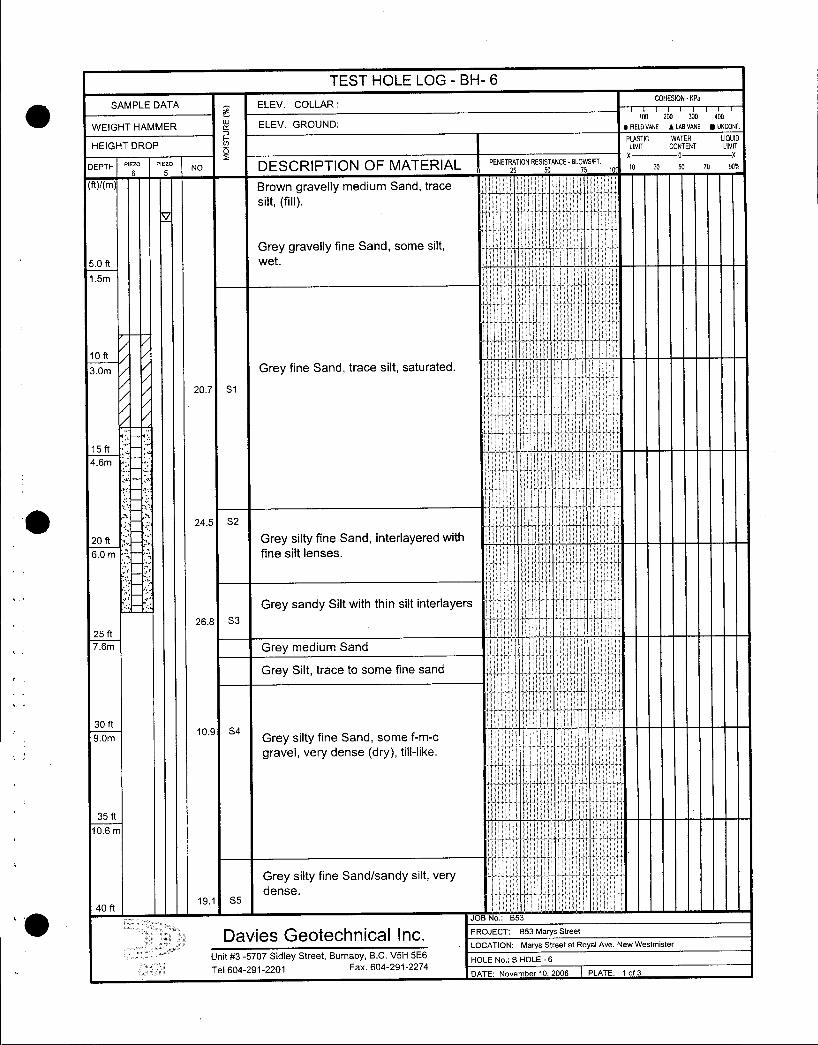
TEST HOLE LOG BH 6
SAMPLE DATAe
ELEV COLLARCOHESION
7TT7T100
KPa
w ELEV GROUND200 300 400
WEIGHT HAMMER FIELDD VANE 1 LAB VANE UNCDNF
F PLASTIC WATER LIQUID
HEIGHT DROP a LIMIT CONTENT LIMIT
DEPTHNEW Pi
5 NO DESCRIPTION OF MATERIAL PENETRA25TION RESISTANCE
BL05SIFT t0 X0 30 50 70 90
MYm Brown gravelly medium Sand trace
silt fillI
i
Grey gravelly fine Sand some silt
50 ft wet
15m
1 o ft
3Om Grey fine Sand trace silt saturated
207 S1
15ft
46m
ij
245 S2
20 ft Grey silty fine Sand interlayered with
60 m fine silt lenses
Grey sandy Silt with thin silt interlayers268 S3
I25 ft
76m Grey medium Sand
Grey Silt trace to some fine sand
30 ft
90nn109 s4
Grey silty fine Sand somefmc
gravel very dense dry tilllike
35 ftV
I106 m
i
Grey silty fine Sandsandy silt very
dense191 S5
I40 ftr JOB No B53
Davies Geoechnical Inc PROJECT B53 Marys Street
LOCATION Marys Street at Royal Ave New Westmister
Unit 3 5707 Sidley Street Burnaby BC V5H 5E6HOLE No B HOLE 6
Tel 6042912201 Fax 6042912274DATE November 10 2006 PLATE 1 of3

TEST HOLE LOG BH 6
SAMPLE DATA ELEV COLLARCONESION KPa
WELEV GROUND
100 200 300 400
WEIGHT HAMMER FIELDVANE 1 LABVANE UNCONF
F PLASTIC WATER LIQUIDHEIGHT DROP 0 LIMIT CONTENT LIMIT
DEPTHP
NO DESCRIPTION OF MATERIAL PENET25TIONRES150TANCEBLO551FT 10 10 30 50 70 90
ftm1 1
Grey silty fine Sand sandy Silt very
3dense
246 S6
450 ft
137m SPT 2759107
500 ftS7
152mGrey fine sandy Silt hard
550 ft
167m
APT 122 X50
r
600 ft
182m
S8 Grey Silt trace sand to some sand
very dense
I
650
198m
SPT k721137
700
213m
S9 Grey Silt to silty Sand very dense
i
750 ft
228
i
SPT 205q70 I I
800
It6 JOB No 853
Davies eoechnlcal Inc PROJECT B53 Marys Street
LOCATION Marys Street at Royal Ave New Westmister
Unit 3 5707 Sidley Street Burnaby BC V5H 5E6HOLE No B HOLE 7
Tel 6042912201 Fax 6042912274DATE November 10 2006 PLATE 2 of 3
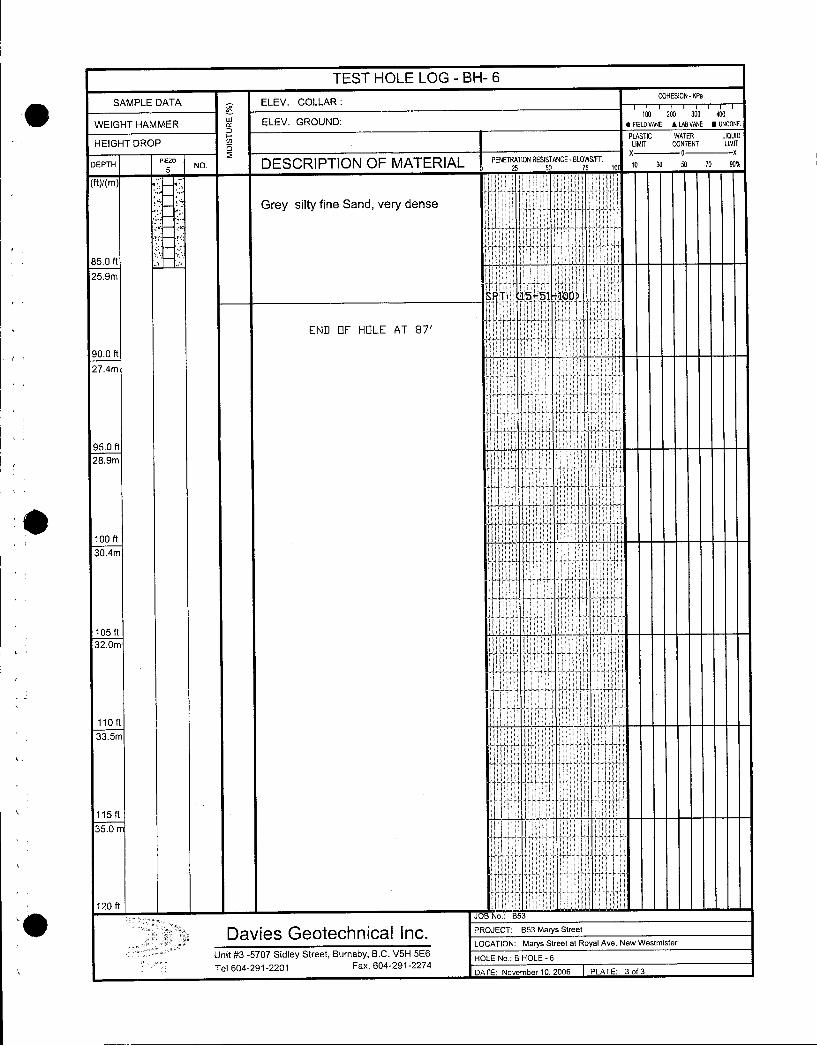
TEST HOLE LOG BH 6
SAMPLE DATA ELEV COLLARCOHESION KPa
W ELEV GROUNDloo 200 300 400
WEIGHT HAMMER FIELDVANE ALABVANE UNCONF
PLASTIC WATER LIQUIDHEIGHT DROP 0 LIMIT CONTENT LIMIT
DEPTH P5 NO DESCRIPTION OF MATERIAL PENETRA25TION RESISTANCE BL05SIFT 19 0 30 so 70 90
Grey silty fine Sand very dense
850 ft
259m
tP T 1 1551 100
END F HOLE AT 871
r900 ft
274m
950 ft
289m
100 ft
I
105 ft
32Om
i
1101133
5m 115
ft35
0 120ft
I JOB No
853 DaviesGeQLech Inical Inc PROJECT B53 MarysStreet
J LOCATION Marys Street at Royal Ave New
Westmister Unit3 5707 Sidley Street BurnabyBC V5H5E6 HOLE No B HOLE
6Tel604291 2201 Fax6042912274 DATE November 10 2006 PLATE 3 of
3
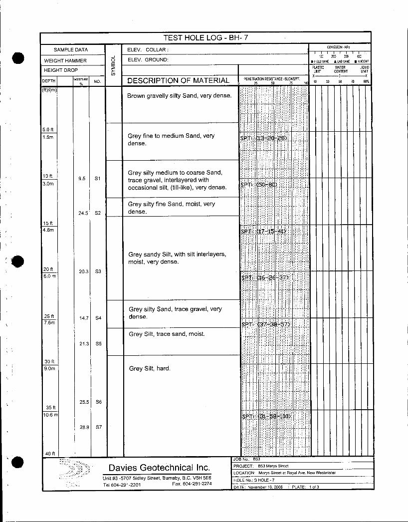
TEST HOLE LOG BH 7
SAMPLE DATA ELEV COLLARCOHESION KPa
100 zoo 300 aoo
WEIGHT HAMMERm
ELEV GROUND FiEnvANE LAB VANE UNCONF
HEIGHT DROP PLMITC CONTENT LIMITDEPTH
MOISTURENO DESCRIPTION OF MATERIAL PENETRATION RESISTANCE BLOWSFF
MAMBrown gravelly silty Sand very dense
EE
50 ft
15m Grey fine to medium Sand very SPT 132 z8dense
loft Grey silty medium to coarse Sands5 s1 trace gravel interlayered with
30m SPT 508occasional silt tilllike very dense
Ii
Grey silty fine Sand moist very
245 S2 dense
15 ft
46m PTi 1771541ES
Grey sandy Silt with silt interlayersF
moist very dense
20 ft203 S3
60 m BPT 162E37Tt
Grey silty Sand trace gravel very25 ft 147 S4 dense76m SPT 373 57
Grey Silt trace sand moist
213 S5
L
30 ft
9om Grey Silt hard I
255 S6
35 ft
106 m I8PT 315 100
289 S7I
40 ft
n
JOB No B53
Davies Geoechnlcal Inc PROJECT B53 Marys Street
LOCATION Marys Street at Royal Ave New Westmister
Unit 3 5707 Sidley Street Burnaby BC V5H 5E6HOLE No B HOLE 7
Tel 6042912201 Fax 6042912274DATE November 10 2006 PLATE 1f3
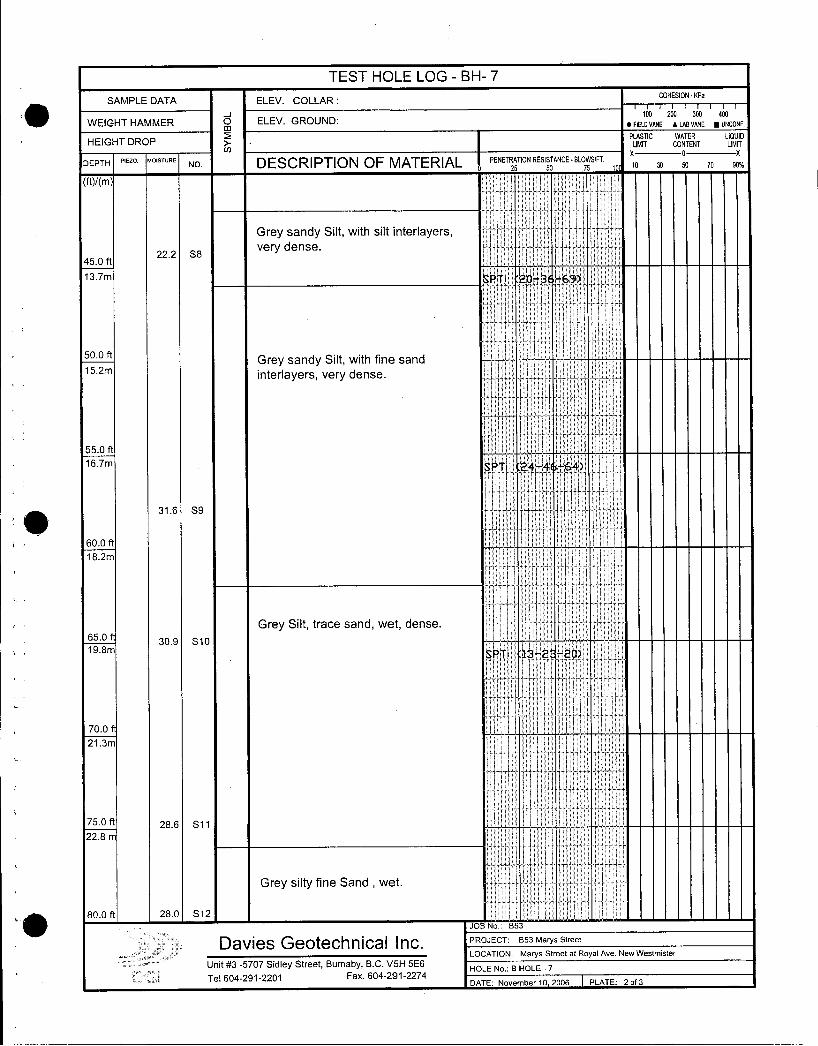
TEST HOLE LOG BH 7
I ISAMPLE DATA ELEV COLLAR
COHESION
WEIGHT HAMMER m ELEV GROUND100 zoo 300 aoo
FIELO VANE 1 LAB VANE UNCONF
PLASTIC WATER LIQUIDHEIGHT DROP LIMIT CONTENT LIMIT
DEPTH FIE20 MOISTURENO DESCRIPTION OF MATERIAL PENETRATION RESISTANCE BLO5SIFT
X OX
1010 30 50 70 90
Grey sandy Silt with silt interlayers
222 ssvery dense
450 ft
137m SPTI 203 69
500 nGrey sandy Silt with fine sand
152minterlayers very dense
550 ft
167m SPTI 244664
I316 S9
600 ft
182m
is
Grey Silt trace sand wet dense650
309 S 10198m
SPTI 132 20
700
213m
750 ft 286 S11
228 m
Grey silty fine Sand wet
800 ft280 S12
JOB No 853
Davies Geotechnical Inc PROJECT B53 Marys Street
LOCATION Marys Street at Royal Ave New Westmister
Unit 3 5707 Sidley Street Burnaby BC V51H 5E6HOLE No B HOLE 7
Tel 6042912201 Fax 6042912274DATE November 10 2006 PLATE 2of3
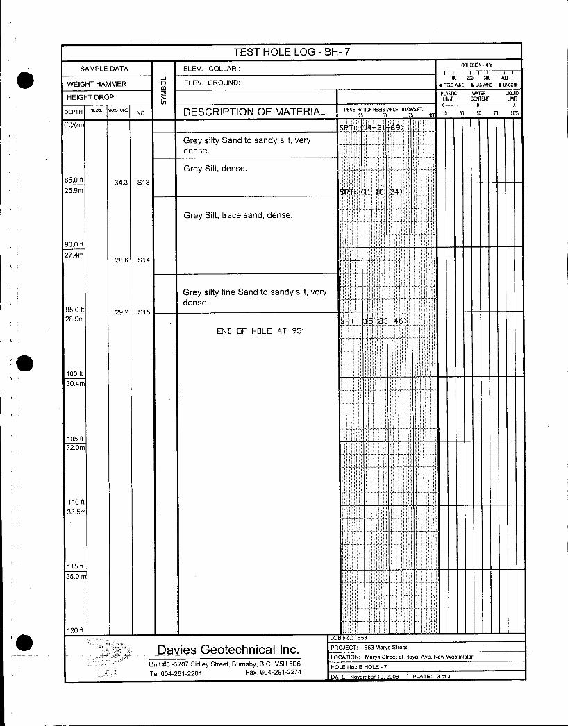
TEST HOLE LOG BH 7
SAMPLE DATA ELEV COLLARCOHESION IPa
J 100 200 300 400
WEIGHT HAMMER Om ELEV GROUND FIELDVANE LAevANE uNCONF
PLASTIC WATER LIQUIDHEIGHT DROP LIMIT CONTENT LIMIT
x o x
DEPTHPIEZO MOISTURE
NO DESCRIPTION OF MATERIAL PENETRATION RESISTANCE81OSSIFT 10 10 30 50 70 90
25 50
ftm SPTI 1431 69
Grey silty Sand to sandy silt verydense
Grey Silt dense
850 It 343 S13
259m SPTI 111824
Grey Silt trace sand dense
900 ft
274m286 S14
Grey silty fine Sand to sandy silt very
dense950 ft 292 S15289m SPTI 152 46
END F HOLE AT 95
II
100 ft
304mI
105 It
320mt
110ft
335m
115 ft
350 m
120 ftt JOB No B53
Davies Geotechnical Inc PROJECT B53 Marys Street
LOCATION Marys Street at Royal Ave New Westmister
Unit 3 5707 Sidley Street Burnaby BC V5H 5E6HOLE No B HOLE 7
Tel 6042912201 Fax 6042912274DATE November 10 2006 PLATE 3 of 3
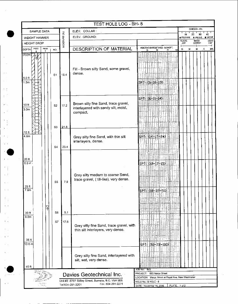
TEST HOLE LOG BH 8
SAMPLE DATA ELEV COLLARCOHESION KPa
1010w ELEV GROUND DV
200 Sao 400
UNCDNFWEIGHT HAMMER FIELD VANE ae vANE UN
N PLASTIC WATER LIQUID
HEIGHT DROP LIMIT CONTENT uMlr
X0 x
DEPTH Pieo PIo NO DESCRIPTION OF MATERIAL PENETRA25TION RESISTANCE BLOSSFT 10 30 50 70 90h
MAM
Fill Brown silty Sand some gravel
S1 104dense
50 ft
15m SPT 616 19
SPT 611 4
loft S2 17 2Brown silty fine Sand trace gravel
3om c interlayered with sandy silt moist
compact
S3 218
15ft
46m Grey silty fine Sand with thin silt SK 1417 24
interlayers dense
S4 234
20 ft
60 m SPTI 1217 15
Grey silty medium to coarse Sand
s5 79trace gravel tilllike very dense
25 ft
76m SPTr 183151I
30 ft S6 91
S7 176
Grey silty fine Sand trace gravel with
thin silt interlayers very dense
t
35 ft
106 m SPT 507 1001l
Grey silty fine Sand interlayered with
silt wet very dense
40ft4 I I
JOB No B53
DavieseoechnicalInc PROJECT B53 Marys Street
LOCATION Marys Street at Royal Ave New Westmister
Unit 3 5707 Sidley Street Burnaby BC V51H 5E6HOLE No B HOLE 8
Tel 6042912201 Fax 6042912274DATE November 10 2006 PLATE 1 of 2
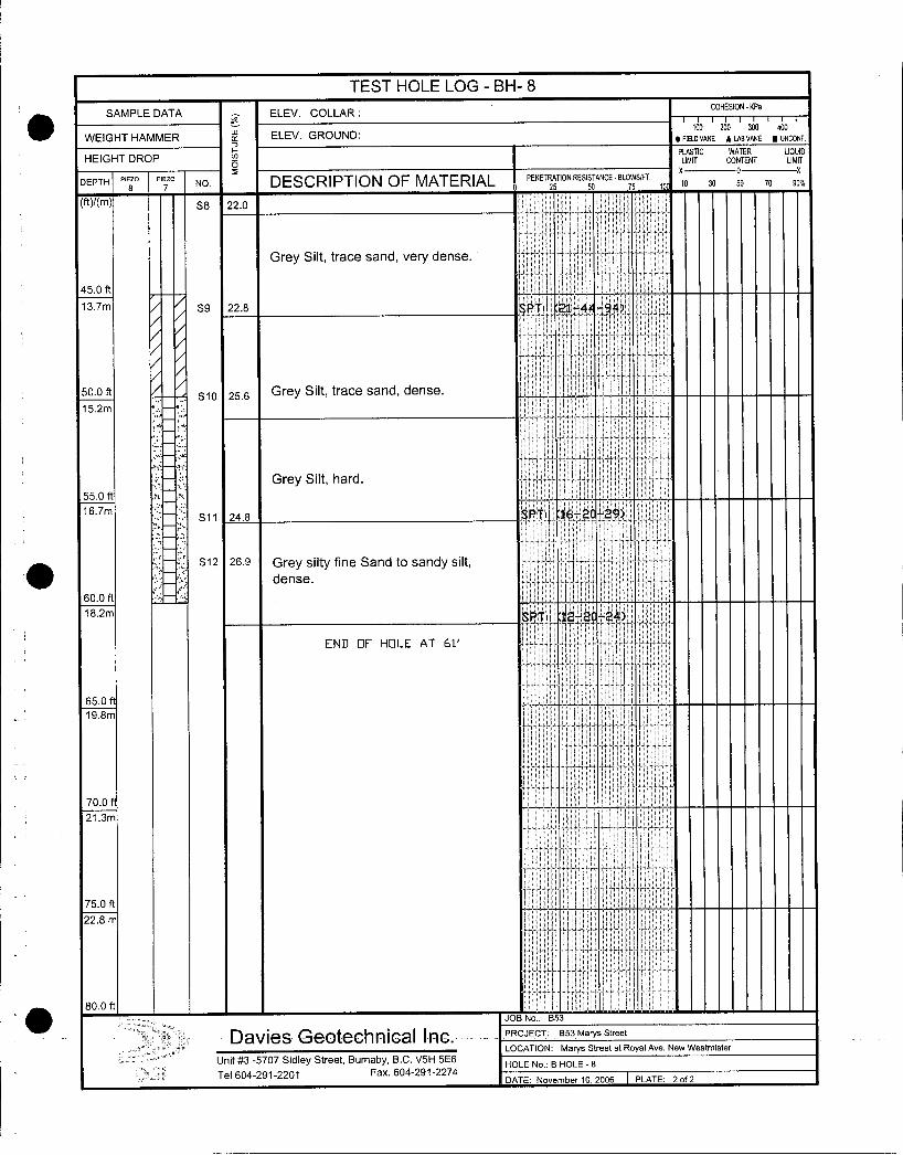
TEST HOLE LOG BH 8
SAMPLE DATA ELEV COLLARCOHESION KPa
100
WEIGHT HAMMER of ELEV GROUND FELDVANE
ZD
A LABVANE M UNCONF
F PLASTIC WATER LIQUIDHEIGHT DROP LIMIT CONTENT LIMIT
X 0
DEPTHPi
6o 7 NO DESCRIPTION OF MATERIAL PENET25TIONRESIANCEBLOSSIFf 10 10 30 50 70 90
ftAmI
S8 220
Grey Silt trace sand very dense
450 ft
137m S9 228 SpTI 214494
500 fts10 25s Grey Silt trace sand dense
152m152m
IGrey Silt hard
550 ft
167mS11 248 SPTI 162 29
S12 269 Grey silty fine Sand to sandy siltdense
600 ft
182m SPTI 122C24
END F HOLE AT 611
650
198m
700
213m
750 ft
228 m
800 ftJOB No B53
Davies G@OteGhifliGBl IncPROJECT B53MarysStreet
LOCATION Marys Street at Royal Ave New Westmister
Unit 3 5707 Sidley Street Bumaby BC V5H 5E6HOLE No B HOLE 8
Tel 6042912201 Fax 6042912274DATE November 10 2006 PLATE 2f2
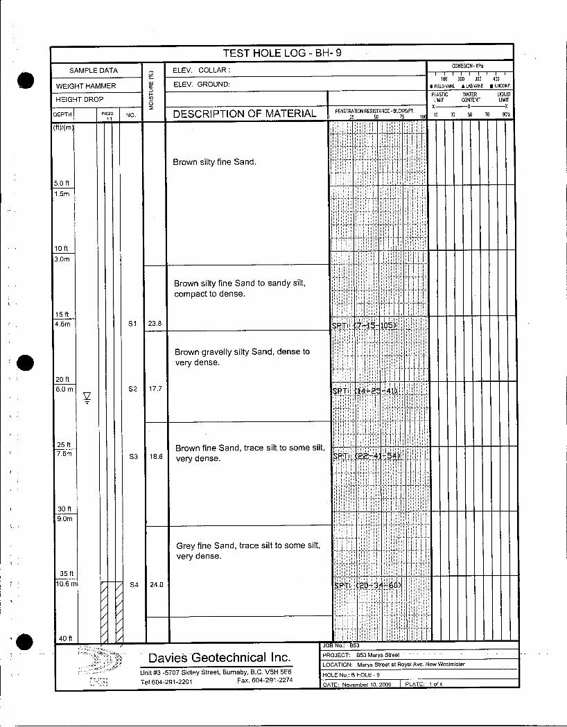
TEST HOLE LOG BH 9
SAMPLE DATA ELEV COLLARCOHESION KPa
ai 100ELEV GROUND FIEDVANE
20
A LABVANE N UNCONFWEIGHT HAMMER
H PLASTIC WATER LIQUID
HEIGHT DROP LIMIT CONTENT LIMIT
2 0x
DEPTH PIEZO NO DESCRIPTION OF MATERIAL PENETRATION RESISTANCE BLOWSFT XO 30 50 70 9011 25 50 75 10
ftKmI I i
Brown silty fine SandEi
50 ft
15m
I
loft
30m i
Brown silty fine Sand to sandy silt
compact to dense
E
15 ft
46m S1 238 SPTI 715 105
Brown gravelly silty Sand dense to
very dense
20 ft
60 m S2 177 PTI 142 41
25 ftBrown fine Sand trace silt to some silt
76mS3 186
very dense PTI 224 54
30 ft
9Om
Grey fine Sand trace silt to some silt
very dense
35 ft
106 m S4 240 tPTI 203 60
I I
40 ft I I II
JOB No B53
Davies Geotechnical Inc PROJECT B53Marys Street
LOCATION Marys Street at Royal Ave New Westmister
Unit 3 5707 Sidley Street Burnaby BC V5H 5E6HOLE No 8 HOLE 9
Tel 6042912201 Fax 6042912274DATE November 10 2006 PLATE 1 of 4
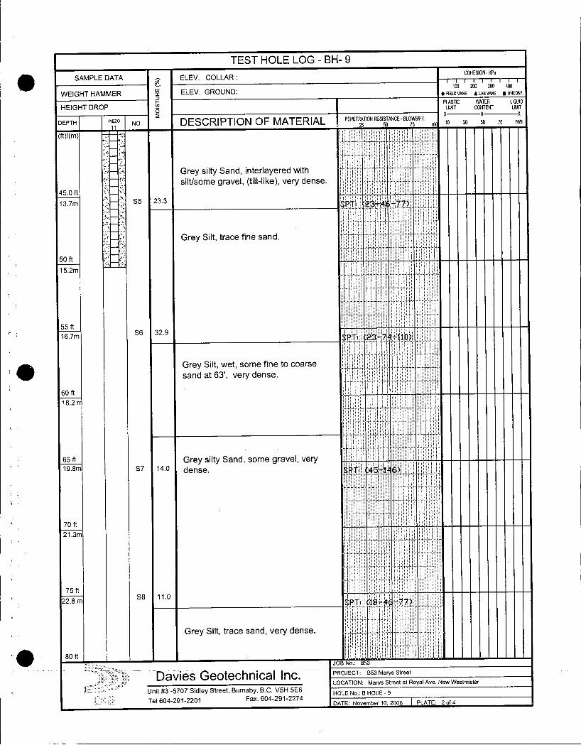
TEST HOLE LOG BH 9
SAMPLE DATAe
ELEV COLLARCOHESIONKPa
ELEV GROUNDtoo 200 300 aoo
WEIGHT HAMMER K
FFIELD VANE ALABVANE UNCONF
PLASTIC WATER LIQUID
HEIGHT DROPO
LIMIT CONTENT LIMIT
PIEZODEPTH NO DESCRIPTION OF MATERIAL PENETRATION RESISTANCE BLOWSFr10 30 SD 70 90
25 50 75 10
MAM j
Grey silty Sand interlayered with
siltsome gravel tilllike very dense
450 ft
137m S5 233 SPTI 234677
Grey Silt trace fine sand
50 ftI
152m
55 ft
167mS6 329
SPT237110
Grey Silt wet some fine to coarse
sand at 63 very dense
60 ft
182
i
65 ft Grey silty Sand some gravel very198m S7 140 dense P71 451 6
t
I
70 ft
213m
i
75 ft
228 mS8 110 SPT1I4184 77
Grey Silt trace sand very dense
80ftIJOB No B53
Davies Geotechnica Inc PROJECT B53 Marys Street
LOCATION Marys Street at Royal Ave New Westmister
Unit 3 5707 Sidley Street Burnaby BC V5H 5E6HOLE No B HOLE 9
Tel 6042912201 Fax 6042912274DATE November 10 2006 PLATE 2 of 4
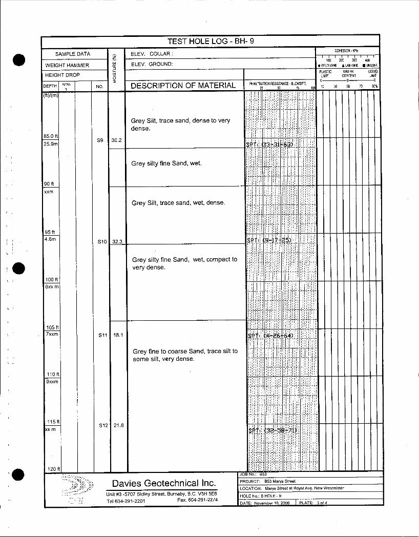
TEST HOLE LOG BH 9
I ISAMPLE DATA
oELEV COLLAR
COHESION
ELEV GROUNDtoa 200 390 400
WEIGHT HAMMER K FIELD VANE SLAB VANE UNCONF
PLASTIC WATER LIQUIDHEIGHT DROP o LIMIT CONTENT LIMIT
DEPTH Piz NO DESCRIPTION OF MATERIAL0 PENETRA25
TION RESISTANCETANCEBLO5SIFT 10 x0 30 50 70 90
Grey Silt trace sand dense to very
dense
850 ft
259mS9 302
SPTI 133163
Grey silty fine Sand wet
90 ft
xxm
Grey Silt trace sand wet dense
95 ft
f
46mS10 323 SPTI 917 25
Grey silty fine Sand wet compact to
very dense
100 ft
6xx m
105 ft
7xxm S11 181 SPTI 42664
Grey fine to coarse Sand trace silt to
some silt very dense
110 ft
9xxm
i
115 ftS12 218
xx m SPTI 325 71
o120 ft
JOB No 853
Davies Geotechnical Inc PROJECT B53 Marys Street
LOCATION Marys Street at Royal Ave New Westmister
Unit 3 5707 Sidley Street Burnaby BC V511 5E6HOLE No B HOLE 9
Tel 6042912201 Fax 6042912274ADATE November 10 2006 PLATE 3 of 4
i
i
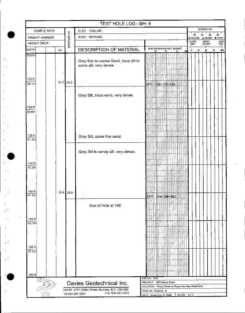
TEST HOLE LOGBH9
SAMPLE DATA ELEV COLLARCOHESION KPa
WEIGHT HAMMER ELEV GROUND100 200 300 400
SFIELD VANE A LAB VANE UNCONF
PLASTIC WATER LIQUIDHEIGHT DROP
OLIMIT CONTENT LIMIT
DEPTH NO DESCRIPTION OF MATERIAL PENETRATION RESISTANCE BLOWSFT
Grey fine to coarse Sand trace silt to
some silt very dense
9
125 ft
381mS13 202
PTI 307 45
Grey Silt trace sand very dense
130 ft
396m
135 ftGrey Silt some fine sand
411 m
Grey Silt to sandy silt very dense
140 ft I
422m
I I
145 ft S14 259441 m
PTI 243896
End of Hole at 146
II150 ft
457m
t
155 ft
472mj t t
160 ft
n
JOB No 853
Davies Geotechnlcal Inc PROJECT B53 Marys Street
LOCATION Marys Street at Royal Ave New Westmister
Unit 3 5707 Sidley Street Burnaby BC V5H 5E6HOLE No B HOLE 9
Tel 6042912201 Fax 6042912274DATE November 10 2006 PLATE 4 of 4
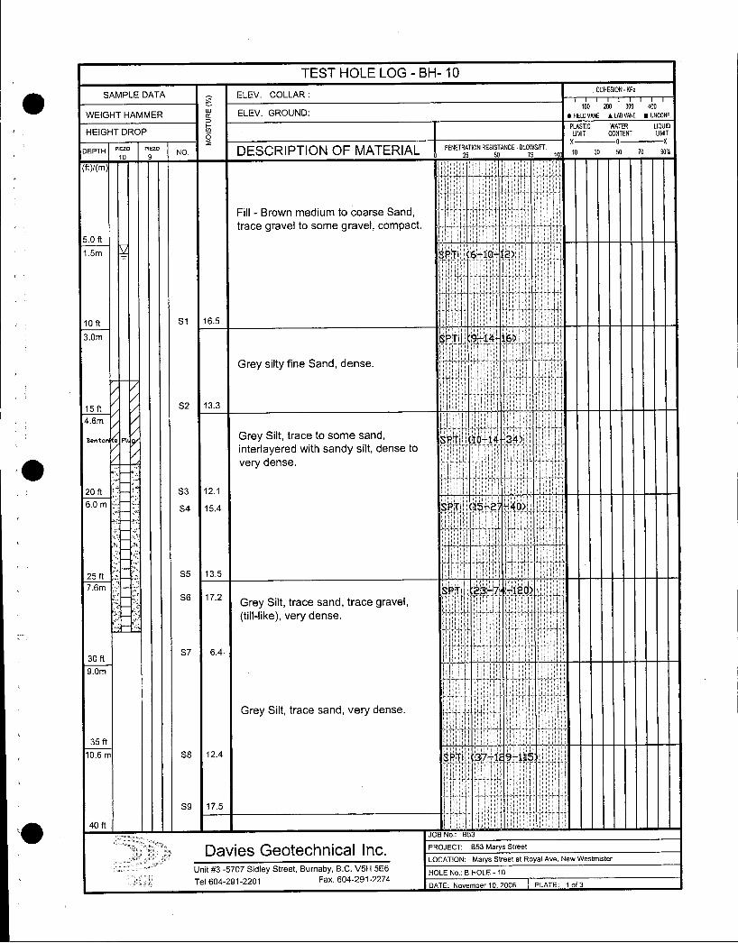
TEST HOLE LOG BH 10
SAMPLE DATA ELEV COLLARCOHESION KPa
W ELEV GROUNDtoo 200 300 ao0
WEIGHT HAMMER S FIELD VANE ALABVANE UNCONF
PLASTIC WATER LIQUIDHEIGHT DROP
pLIMIT CONTENT LIMIT
DEPTH Poo v9 NO DESCRIPTION OF MATERIAL PENETRATION RESISDTANCEBLOSSIFT 10 X0 30 50 10 9025 s
MYm I
Fill Brown medium to coarse Sandtrace gravel to some gravel compact
50 ft
15m SPTI 61012
loft S1 165 j30m SPTI 914 16
Grey silty fine Sand dense
15 ft S2 133
46m
Denton a Pl Grey Silt trace to some sand SPTI 401434 Iinterlayered with sandy silt dense to
very dense
20 ft S3 121
60 mS4 154
ISPTI 152 40
25 ft S5 135
6m TI 23 7 120S6 172
Grey Silt trace sand trace graveltilllike very dense
30 ftS7 64
30 ft
Grey Silt trace sand very dense
35 ft
106 m S8 124 SPTI 371 9115
i
S9 175
40 ft IJOB No B53
Davies Geotechnlcai Inc PROJECT B53 Marys Street
LOCATION Marys Street at Royal Ave New Westmister
Unit 3 5707 Sidley Street Burnaby BC V5H 5E6HOLE No B HOLE 10
Tel 6042912201 Fax 6042912274DATE November 10 2006 PLATE 1 of 3
TEST HOLE LOG BH 10
SAMPLE DATA ELEV COLLARCOHESION KPa
WEIGHT HAMMER X ELEV GROUND FIELOANE ZALABVANE NUNCONF
PLASTIC WATER LIOUIOHEIGHT DROP
OLIMIT CONTENT LIMIT
OX
DEPTH P9ZO NO DESCRIPTION OF MATERIAL PENETRATION RESI50TANCEBLOSSIFT 10 XO 30 50 70 9025
ftm
Grey sandy Silt interlayered with silty
S10 129fine sand very dense
450 ft
137m SPT1 20 3 70
S11 130
500 ft
152m
550 ft
167m SPT 11575q64Grey silty fine Sand to sandy siltdense
600 ft S12 127
182m SPTi 132 45
650 ft
198m S13 224 SPT 1021 51
Grey silty fine Sand dense
700
213m
S14 290
750 ft Grey sandy Silt to silt with part of
22s s1s 307 leaves interlayers denseSPT 132127
i
r
800 ft S161282JOB No B53
Davies Geotechnical Inc PROJECT B53 Marys Street
LOCATION Marys Street at Royal Ave New Westmister
Unit 3 5707 Sidley Street Burnaby BC V511 5E6HOLE No B HOLE 8
Tel 6042912201 Fax 6042912274DATE November 10 2006 PLATE 2 of 3
TEST HOLE LOG BH 10
SAMPLE DATAo
ELEV COLLARCOHESION KPa
100 200 300 400
WEIGHT HAMMER ELEV GROUND FiELDVANE ALABVANE UNCONR
H PLASTIC WATER LIQUID
HEIGHT DROPo
LIMIT CONTENT LIMIT
DEPTH P9ZO NO DESCRIPTION OF MATERIAL PENETRATION RESISTANCE 8L SIFT
25
T
Grey silty fine Sand moist very
dense
850 ft
259m SPTI 142 55
S17 2173j
It 1 t
END F HOLE AT 87
900 ft
274m
950 ftI
289m
100 ft
304m
i
105 ft
320m
110 ft
335m
115ft
350
44
I
l120 ft
JOB No B53
Davies Geoechnlcal Inc PROJECT B53 Marys Streetl
LOCATION Marys Street at Royal Ave New Westmister
Unit 3 5707 Sidley Street Burnaby BC V5H 5E6HOLE No B HOLE 8
Tel 6042912201 Fax 6042912274DATE November 102006 PLATE 3 of 3


![Elmārs Kokorišs, Horizon eksperts · • Virtualizācija platforma Tīkls Darba stacijas Lietotāji. DB Horizon µ }u ] l] ] Store PDA /vÀ v ]Ì ]i BPO Klientu WS E5W } o](https://img.pdfslide.net/doc/110x75/5ed36b57f15ef3476a72990b/elmrs-kokoris-horizon-eksperts-a-virtualizcija-platforma-tkls-darba-stacijas.jpg)