Embed Size (px)
Citation preview
STATE OF NORTH CAROLINA
DEPARTMENT OF TRANSPORTATION
ROY COOPER JAMES H. TROGDON, III GOVERNOR SECRETARY
Mailing Address:
NC DEPARTMENT OF TRANSPORTATION NATURAL ENVIRONMENT SECTION
1598 MAIL SERVICE CENTER
RALEIGH NC 27699-1598
Telephone: (919) 707-6000
Fax: (919) 212-5785 Customer Service: 1-877-368-4968
Website: www.ncdot.gov
Location:
1020 BIRCH RIDGE DRIVE RALEIGH NC 27610
March 6, 2017
Washington Regulatory Field Office
U. S. Army Corps of Engineers
2407 West 5th Street
Washington, North Carolina 27889
ATTN: Mr. Tom Steffens
NCDOT Coordinator
N.C. Dept. of Environmental Quality
Division of Coastal Management
400 Commerce Avenue
Morehead City, NC 28557
ATTN: Mr. Stephen Lane
NCDOT Coordinator
Subject: Revised Application for Section 10 Permit, Nationwide Permits 12, 23, & 33, Section
401 Water Quality Certification, Buffer Authorization, and CAMA Major
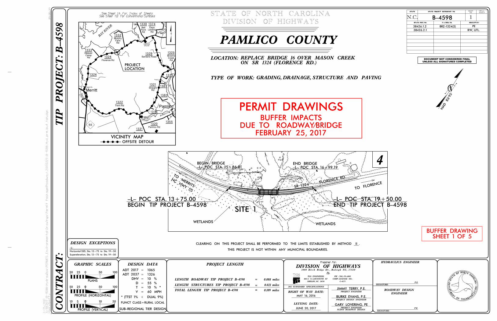
Development Permit for the Proposed Replacement of Bridge No. 16 over Mason Creek
on SR 1324 (Florence Rd) in Pamlico County, North Carolina; TIP No. B-4598; Federal
Aid Project No. BRZ-1324(5); Debit $475 from WBS No. 38426.1.2
Reference: Permit Application dated January 13, 2017
Dear Sirs,
The NCDOT submitted a permit application to your agencies for this project on January 13, 2017;
however, due to Session Law 2015-246 (§143-214.23A. Sec. 13.3(b)) buffer limits in coastal wetlands
have changed. Therefore the permit and buffer drawings have been modified. In addition to the revised
buffer impacts, the proposed temporary work pad has been removed and proposed stormwater discharge
outlets have been relocated out of the revised buffer zones. Please see enclosed copies of the revised
permit drawings, buffer drawings, utility drawings, pre-construction notification, mitigation debit ledger
summary, and CAMA MP1 form for the subject project (there were no changes to MP5).
This project calls for a letting date of June 20, 2017 and a review date of May 2, 2017.
Regulatory Approvals
Section 10 Permit: Application is hereby made for a Section 10 Permit as required for the above-
described activities in accordance with Section 10 of the Rivers and Harbors Act of March 3, 1899 (33
U.S.C. 403)
Section 404 Permit: We anticipate that the bridge replacement, including all approach work will be
authorized under a Section 404 Nationwide Permit (NWP) 23 (Categorical Exclusions), the temporary
work pad under a NWP 33, and utility relocations under a NWP 12 in accordance with Section 404 of the
Clean Water Act (33 U.S.C. 1344).
Section 401 Permit: We anticipate 401 General Certification numbers 3891, 3893, and 3884 will apply to this project. NCDOT is requesting written concurrence from the North Carolina Department of
-----J..J.n_virnnmentaLQuality ,_Di_visjon_of__Water Resources.
Neuse Riparian Buffer Authorization: NCDOT is requesting a Neuse Riparian Buffer Authorization from the North Carolina Department of Environmental Quality, Division of Water Resources.
CAMA Major Development Permit: NCDOT requests that the proposed work be authorized under a Coastal Area Management Act Major Permit. Adjacent riparian landowner certified mail receipts have been provided. Authorization to debit the $475 Permit Application Fee from WBS Element 38426.1.2 is hereby given.
A copy of this revised permit application and its distribution list will be posted at the NCDOT Website at https://connect.ncdot.gov/resources/Environmental. Should you have any questions regarding this · information, please contact Tyler Stanton at (919) 707-6156 or [email protected].
Sincerely,
PhilipS. Harris III, P.E., C.P.M. Natural Environment Section Head
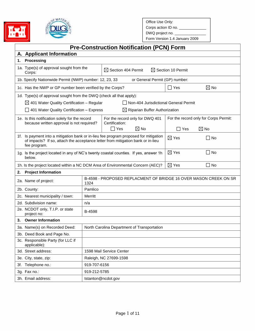
Page 1 of 11
Office Use Only:
Corps action ID no. _____________
DWQ project no. _______________
Form Version 1.4 January 2009
Pre-Construction Notification (PCN) Form A. Applicant Information
1. Processing
1a. Type(s) of approval sought from the Corps:
Section 404 Permit Section 10 Permit
1b. Specify Nationwide Permit (NWP) number: 12, 23, 33 or General Permit (GP) number:
1c. Has the NWP or GP number been verified by the Corps? Yes No
1d. Type(s) of approval sought from the DWQ (check all that apply):
401 Water Quality Certification – Regular Non-404 Jurisdictional General Permit
401 Water Quality Certification – Express Riparian Buffer Authorization
1e. Is this notification solely for the record because written approval is not required?
For the record only for DWQ 401 Certification:
Yes No
For the record only for Corps Permit:
Yes No
1f. Is payment into a mitigation bank or in-lieu fee program proposed for mitigation of impacts? If so, attach the acceptance letter from mitigation bank or in-lieu fee program.
Yes No
1g. Is the project located in any of NC’s twenty coastal counties. If yes, answer 1h below.
Yes No
1h. Is the project located within a NC DCM Area of Environmental Concern (AEC)? Yes No
2. Project Information
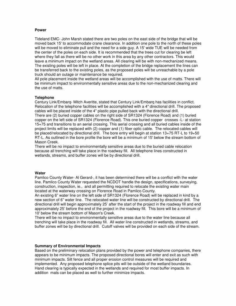
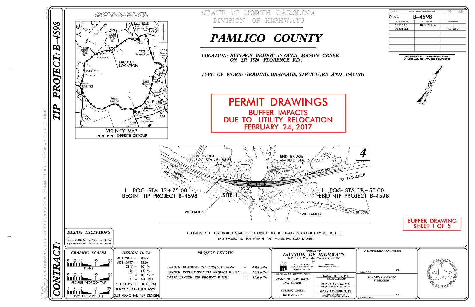
2a. Name of project: B-4598 - PROPOSED REPLACMENT OF BRIDGE 16 OVER MASON CREEK ON SR 1324
2b. County: Pamlico
2c. Nearest municipality / town: Merritt
2d. Subdivision name: n/a
2e. NCDOT only, T.I.P. or state project no:
B-4598
3. Owner Information
3a. Name(s) on Recorded Deed: North Carolina Department of Transportation
3b. Deed Book and Page No.
3c. Responsible Party (for LLC if applicable):
3d. Street address: 1598 Mail Service Center
3e. City, state, zip: Raleigh, NC 27699-1598
3f. Telephone no.: 919-707-6156
3g. Fax no.: 919-212-5785
3h. Email address: [email protected]
Page 2 of 11
4. Applicant Information (if different from owner)
4a. Applicant is: Agent Other, specify:
4b. Name:
4c. Business name (if applicable):
4d. Street address:
4e. City, state, zip:
4f. Telephone no.:
4g. Fax no.:
4h. Email address:
5. Agent/Consultant Information (if applicable)
5a. Name:
5b. Business name (if applicable):
5c. Street address:
5d. City, state, zip:
5e. Telephone no.:
5f. Fax no.:
5g. Email address:
Page 3 of 11
B. Project Information and Prior Project History
1. Property Identification
1a. Property identification no. (tax PIN or parcel ID):
1b. Site coordinates (in decimal degrees): Latitude: 35.1319 Longitude: - 76.6845
(DD.DDDDDD) (-DD.DDDDDD)
1c. Property size: Approximately 30 acres
2. Surface Waters
2a. Name of nearest body of water (stream, river, etc.) to proposed project:
Mason Creek
2b. Water Quality Classification of nearest receiving water: SC; Sw, NSW, HQW
2c. River basin: Neuse
3. Project Description
3a. Describe the existing conditions on the site and the general land use in the vicinity of the project at the time of this application:
swamp, marsh, forest, cropland, some rural residential
3b. List the total estimated acreage of all existing wetlands on the property:
Approximately 4.5 acre
3c. List the total estimated linear feet of all existing streams (intermittent and perennial) on the property:
315'
3d. Explain the purpose of the proposed project:
Replace a functionally obsolete and structurally deficient bridge that is approaching the end of its useful life. Replacement of the bridge will result in safer traffic operations.
3e. Describe the overall project in detail, including the type of equipment to be used:
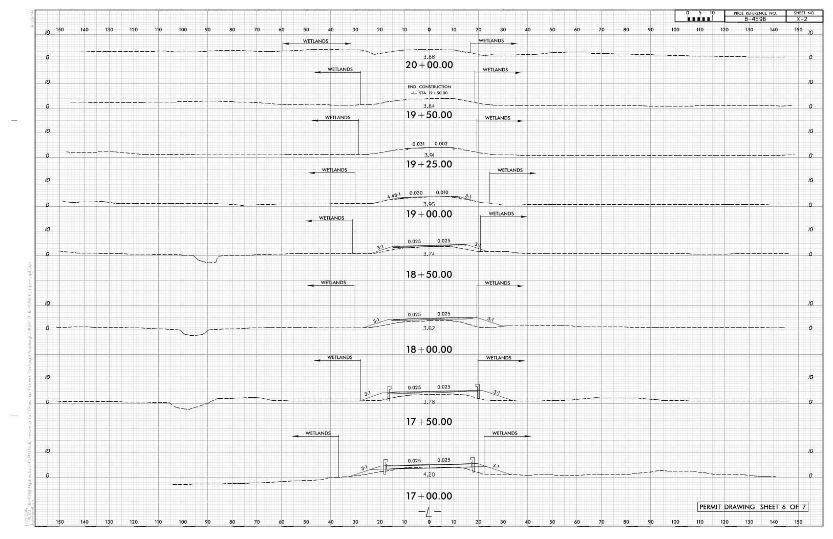
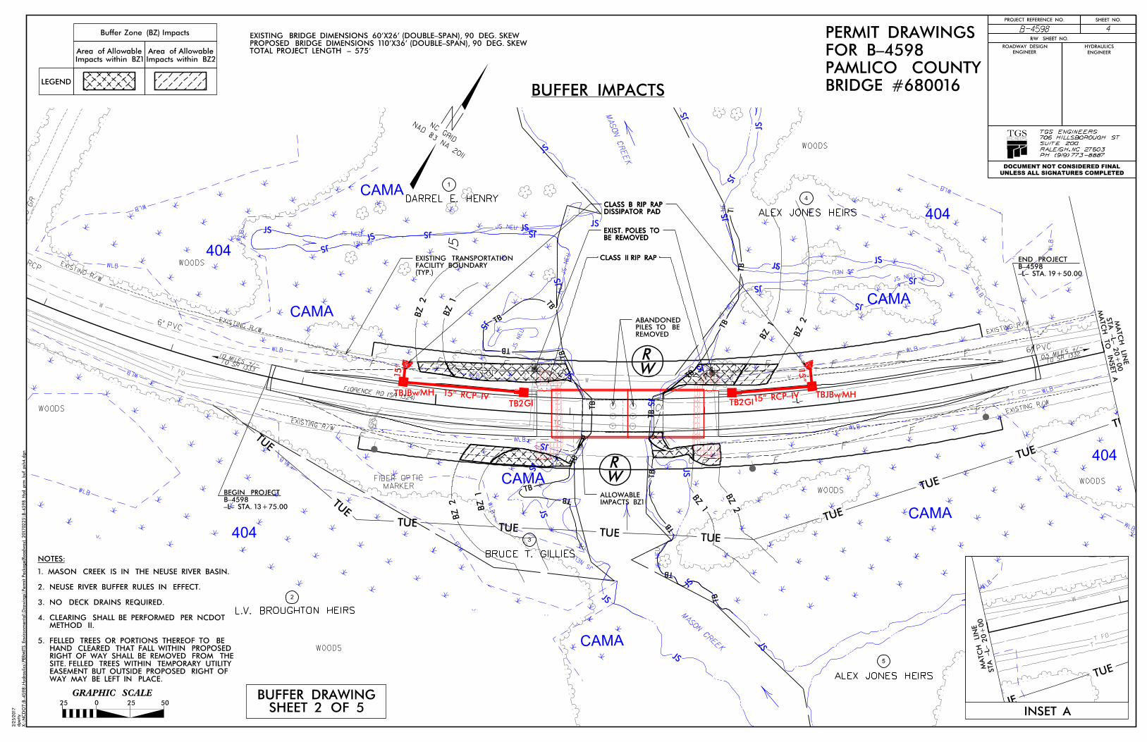
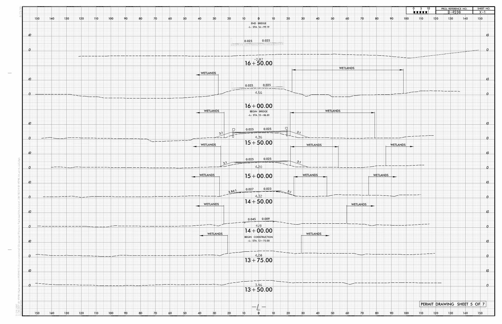
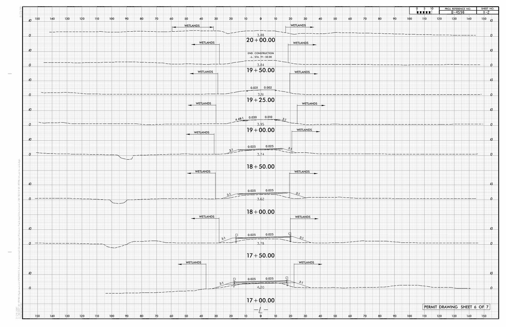
The proposed project will replace Pamlico County Bridge No. 16 on SR 1324 (Florence Road) over Mason Creek. Currently, bridge No. 16 is 61 feet long. The replacement structure will be a bridge approximately 110 feet long providing a minimum of 33.5 feet of clear deck width. Grading, paving, clearing, utility relocation, excavation and fill associated with the roadway and bridge work. Cranes, pile driving equipment, grading equipment, bull dozers, excavators, offroad trucks, and boring machines will be used.
4. Jurisdictional Determinations
4a. Have jurisdictional wetland or stream determinations by the Corps or State been requested or obtained for this property / project (including all prior phases) in the past?
Comments:
Yes No Unknown
4b. If the Corps made the jurisdictional determination, what type of determination was made?
Preliminary Final
4c. If yes, who delineated the jurisdictional areas?
Name (if known): NCDOT
Agency/Consultant Company:
Other:
4d. If yes, list the dates of the Corps jurisdictional determinations or State determinations and attach documentation.
A JD Request was sent on 6/25/12
5. Project History
5a. Have permits or certifications been requested or obtained for this project (including all prior phases) in the past?
Yes No Unknown
5b. If yes, explain in detail according to “help file” instructions.
Please see attached cover letter.
Page 4 of 11
6. Future Project Plans
6a. Is this a phased project? Yes No
6b. If yes, explain.
Page 5 of 11
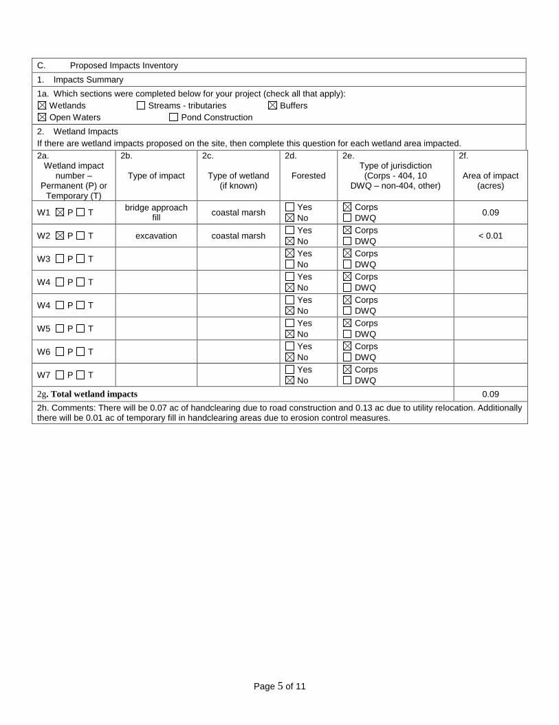
C. Proposed Impacts Inventory
1. Impacts Summary
1a. Which sections were completed below for your project (check all that apply):
Wetlands Streams - tributaries Buffers
Open Waters Pond Construction
2. Wetland Impacts
If there are wetland impacts proposed on the site, then complete this question for each wetland area impacted.
2a. Wetland impact
number – Permanent (P) or
Temporary (T)
2b.
Type of impact
2c.
Type of wetland (if known)
2d.
Forested
2e. Type of jurisdiction
(Corps - 404, 10 DWQ – non-404, other)
2f. Area of impact
(acres)
W1 P T bridge approach
fill coastal marsh
Yes
No
Corps
DWQ 0.09
W2 P T excavation coastal marsh Yes
No
Corps
DWQ < 0.01
W3 P T Yes
No
Corps
DWQ
W4 P T Yes
No
Corps
DWQ
W4 P T Yes
No
Corps
DWQ
W5 P T Yes
No
Corps
DWQ
W6 P T Yes
No
Corps
DWQ
W7 P T Yes
No
Corps
DWQ
2g. Total wetland impacts 0.09
2h. Comments: There will be 0.07 ac of handclearing due to road construction and 0.13 ac due to utility relocation. Additionally there will be 0.01 ac of temporary fill in handclearing areas due to erosion control measures.
Page 6 of 11
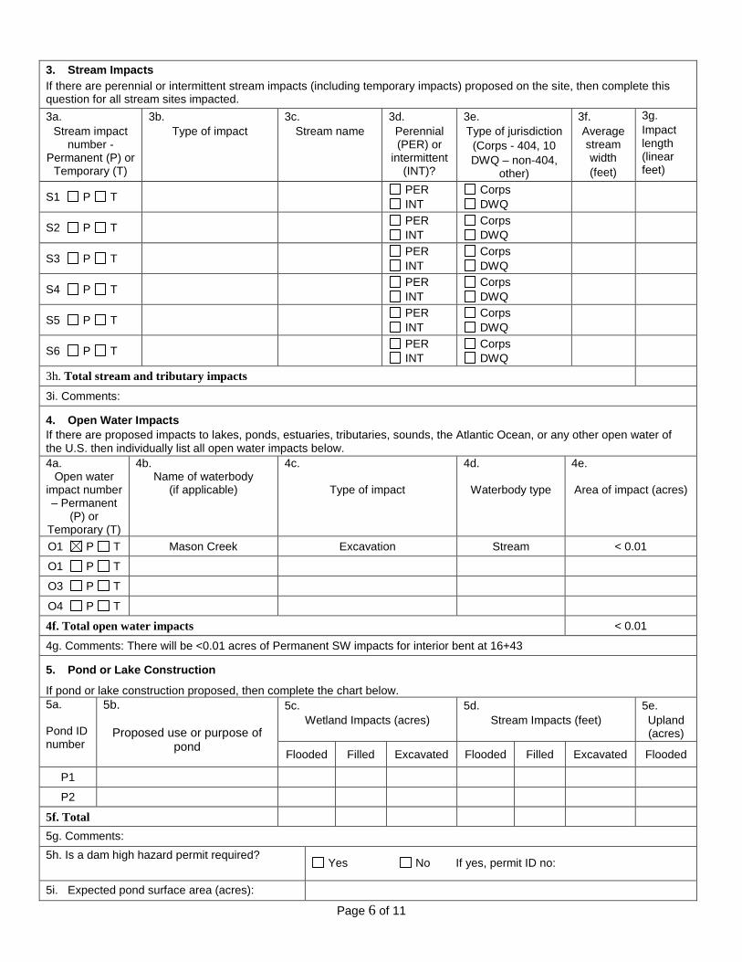
3. Stream Impacts If there are perennial or intermittent stream impacts (including temporary impacts) proposed on the site, then complete this question for all stream sites impacted.
3a.
Stream impact number -
Permanent (P) or Temporary (T)
3b.
Type of impact
3c.
Stream name
3d.
Perennial (PER) or
intermittent (INT)?
3e.
Type of jurisdiction
(Corps - 404, 10
DWQ – non-404, other)
3f.
Average stream width
(feet)
3g.
Impact length (linear feet)
S1 P T PER
INT
Corps
DWQ
S2 P T PER
INT
Corps
DWQ
S3 P T PER
INT
Corps
DWQ
S4 P T PER
INT
Corps
DWQ
S5 P T PER
INT
Corps
DWQ
S6 P T PER
INT
Corps
DWQ
3h. Total stream and tributary impacts
3i. Comments:
4. Open Water Impacts
If there are proposed impacts to lakes, ponds, estuaries, tributaries, sounds, the Atlantic Ocean, or any other open water of the U.S. then individually list all open water impacts below.
4a. Open water
impact number – Permanent
(P) or Temporary (T)
4b. Name of waterbody
(if applicable)
4c.
Type of impact
4d.
Waterbody type
4e. Area of impact (acres)
O1 P T Mason Creek Excavation Stream < 0.01
O1 P T
O3 P T
O4 P T
4f. Total open water impacts < 0.01
4g. Comments: There will be <0.01 acres of Permanent SW impacts for interior bent at 16+43
5. Pond or Lake Construction
If pond or lake construction proposed, then complete the chart below.
5a. Pond ID number
5b.
Proposed use or purpose of pond
5c.
Wetland Impacts (acres)
5d.
Stream Impacts (feet)
5e.
Upland (acres)
Flooded Filled Excavated Flooded Filled Excavated Flooded
P1
P2
5f. Total
5g. Comments:
5h. Is a dam high hazard permit required?
Yes No If yes, permit ID no:
5i. Expected pond surface area (acres):
Page 7 of 11
5j. Size of pond watershed (acres):
5k. Method of construction:
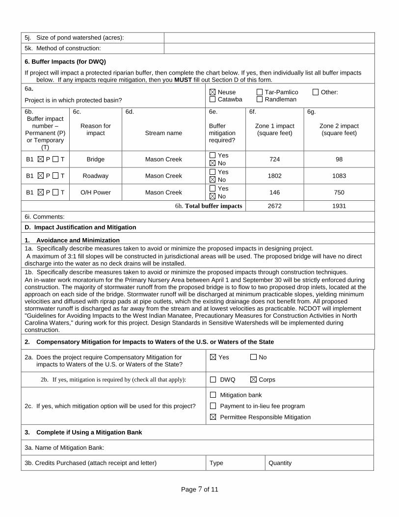
6. Buffer Impacts (for DWQ)
If project will impact a protected riparian buffer, then complete the chart below. If yes, then individually list all buffer impacts below. If any impacts require mitigation, then you MUST fill out Section D of this form.
6a.
Project is in which protected basin?
Neuse Tar-Pamlico Other: Catawba Randleman
6b. Buffer impact
number – Permanent (P) or Temporary
(T)
6c.
Reason for impact
6d.
Stream name
6e. Buffer mitigation required?
6f.
Zone 1 impact (square feet)
6g.
Zone 2 impact (square feet)
B1 P T Bridge Mason Creek Yes
No 724 98
B1 P T Roadway Mason Creek Yes
No 1802 1083
B1 P T O/H Power Mason Creek Yes
No 146 750
6h. Total buffer impacts 2672 1931
6i. Comments:
D. Impact Justification and Mitigation
1. Avoidance and Minimization
1a. Specifically describe measures taken to avoid or minimize the proposed impacts in designing project.
A maximum of 3:1 fill slopes will be constructed in jurisdictional areas will be used. The proposed bridge will have no direct discharge into the water as no deck drains will be installed.
1b. Specifically describe measures taken to avoid or minimize the proposed impacts through construction techniques.
An in-water work moratorium for the Primary Nursery Area between April 1 and September 30 will be strictly enforced during construction. The majority of stormwater runoff from the proposed bridge is to flow to two proposed drop inlets, located at the approach on each side of the bridge. Stormwater runoff will be discharged at minimum practicable slopes, yielding minimum velocities and diffused with riprap pads at pipe outlets, which the existing drainage does not benefit from. All proposed stormwater runoff is discharged as far away from the stream and at lowest velocities as practicable. NCDOT will implement "Guidelines for Avoiding Impacts to the West Indian Manatee, Precautionary Measures for Construction Activities in North Carolina Waters," during work for this project. Design Standards in Sensitive Watersheds will be implemented during construction.
2. Compensatory Mitigation for Impacts to Waters of the U.S. or Waters of the State
2a. Does the project require Compensatory Mitigation for impacts to Waters of the U.S. or Waters of the State?
Yes No
2b. If yes, mitigation is required by (check all that apply): DWQ Corps
2c. If yes, which mitigation option will be used for this project?
Mitigation bank
Payment to in-lieu fee program
Permittee Responsible Mitigation
3. Complete if Using a Mitigation Bank
3a. Name of Mitigation Bank:
3b. Credits Purchased (attach receipt and letter) Type Quantity
Page 8 of 11
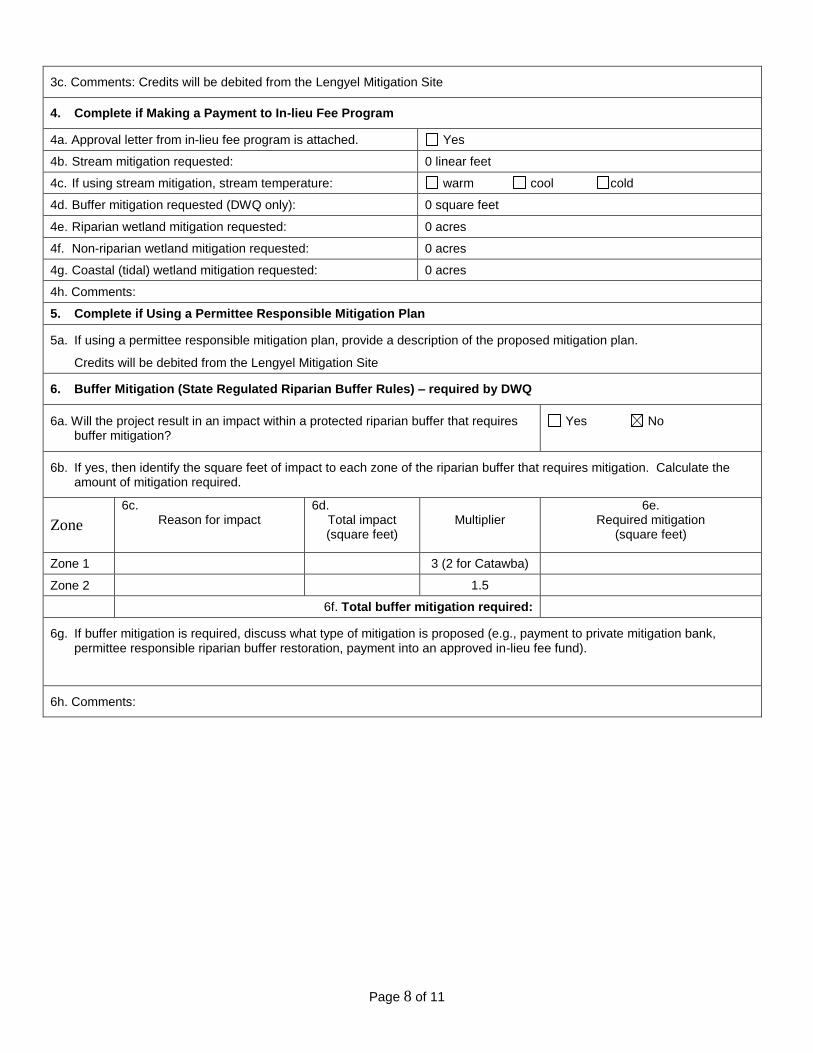
3c. Comments: Credits will be debited from the Lengyel Mitigation Site
4. Complete if Making a Payment to In-lieu Fee Program
4a. Approval letter from in-lieu fee program is attached. Yes
4b. Stream mitigation requested: 0 linear feet
4c. If using stream mitigation, stream temperature: warm cool cold
4d. Buffer mitigation requested (DWQ only): 0 square feet
4e. Riparian wetland mitigation requested: 0 acres
4f. Non-riparian wetland mitigation requested: 0 acres
4g. Coastal (tidal) wetland mitigation requested: 0 acres
4h. Comments:
5. Complete if Using a Permittee Responsible Mitigation Plan
5a. If using a permittee responsible mitigation plan, provide a description of the proposed mitigation plan.
Credits will be debited from the Lengyel Mitigation Site
6. Buffer Mitigation (State Regulated Riparian Buffer Rules) – required by DWQ
6a. Will the project result in an impact within a protected riparian buffer that requires buffer mitigation?
Yes No
6b. If yes, then identify the square feet of impact to each zone of the riparian buffer that requires mitigation. Calculate the amount of mitigation required.
Zone
6c. Reason for impact
6d. Total impact (square feet)
Multiplier
6e. Required mitigation
(square feet)
Zone 1 3 (2 for Catawba)
Zone 2 1.5
6f. Total buffer mitigation required:
6g. If buffer mitigation is required, discuss what type of mitigation is proposed (e.g., payment to private mitigation bank, permittee responsible riparian buffer restoration, payment into an approved in-lieu fee fund).
6h. Comments:
Page 9 of 11
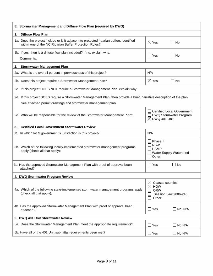
E. Stormwater Management and Diffuse Flow Plan (required by DWQ)
1. Diffuse Flow Plan
1a. Does the project include or is it adjacent to protected riparian buffers identified within one of the NC Riparian Buffer Protection Rules?
Yes No
1b. If yes, then is a diffuse flow plan included? If no, explain why.
Comments: Yes No
2. Stormwater Management Plan
2a. What is the overall percent imperviousness of this project? N/A
2b. Does this project require a Stormwater Management Plan? Yes No
2c. If this project DOES NOT require a Stormwater Management Plan, explain why:
2d. If this project DOES require a Stormwater Management Plan, then provide a brief, narrative description of the plan:
See attached permit drawings and stormwater management plan.
2e. Who will be responsible for the review of the Stormwater Management Plan? Certified Local Government DWQ Stormwater Program DWQ 401 Unit
3. Certified Local Government Stormwater Review
3a. In which local government’s jurisdiction is this project? N/A
3b. Which of the following locally-implemented stormwater management programs apply (check all that apply):
Phase II NSW USMP Water Supply Watershed Other:
3c. Has the approved Stormwater Management Plan with proof of approval been attached?
Yes No
4. DWQ Stormwater Program Review
4a. Which of the following state-implemented stormwater management programs apply (check all that apply):
Coastal counties HQW ORW Session Law 2006-246 Other:
4b. Has the approved Stormwater Management Plan with proof of approval been attached? Yes No N/A
5. DWQ 401 Unit Stormwater Review
5a. Does the Stormwater Management Plan meet the appropriate requirements? Yes No N/A
5b. Have all of the 401 Unit submittal requirements been met? Yes No N/A
Page 10 of 11
F. Supplementary Information
1. Environmental Documentation (DWQ Requirement)
1a. Does the project involve an expenditure of public (federal/state/local) funds or the use of public (federal/state) land?
Yes No
1b. If you answered “yes” to the above, does the project require preparation of an environmental document pursuant to the requirements of the National or State (North Carolina) Environmental Policy Act (NEPA/SEPA)?
Yes No
1c. If you answered “yes” to the above, has the document review been finalized by the State Clearing House? (If so, attach a copy of the NEPA or SEPA final approval letter.)
Comments: NEPA PCE for TIP B-4598
Yes No
2. Violations (DWQ Requirement)
2a. Is the site in violation of DWQ Wetland Rules (15A NCAC 2H .0500), Isolated Wetland Rules (15A NCAC 2H .1300), DWQ Surface Water or Wetland Standards, or Riparian Buffer Rules (15A NCAC 2B .0200)?
Yes No
2b. Is this an after-the-fact permit application? Yes No
2c. If you answered “yes” to one or both of the above questions, provide an explanation of the violation(s):
3. Cumulative Impacts (DWQ Requirement)
3a. Will this project (based on past and reasonably anticipated future impacts) result in additional development, which could impact nearby downstream water quality?
Yes No
3b. If you answered “yes” to the above, submit a qualitative or quantitative cumulative impact analysis in accordance with the most recent DWQ policy. If you answered “no,” provide a short narrative description.
Due to the minimal transportation impact resulting from this bridge replacement, this project will neither influence nearby land uses nor stimulate growth. Therefore, a detailed indirect or cumulative effects study will not be necessary.
4. Sewage Disposal (DWQ Requirement)
4a. Clearly detail the ultimate treatment methods and disposition (non-discharge or discharge) of wastewater generated from the proposed project, or available capacity of the subject facility.
Not applicable.
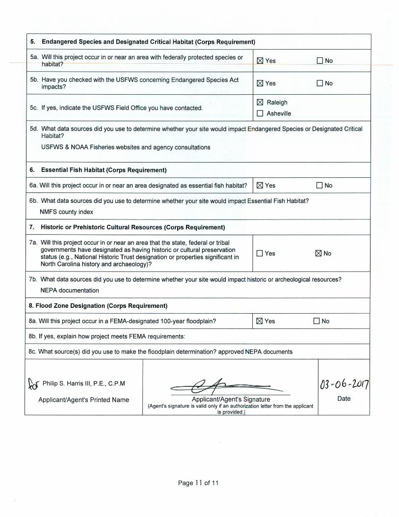
5. Endangered Species and Designated Critical Habitat (Corps Requirement)
Sa. Will this project occur in or near an area with federally protected species or [8] Yes DNo --habitat'? ------
5b. Have you checked with the USFWS concerning Endangered Species Act [8] Yes DNo impacts?
If yes, indicate the USFWS Field Office you have contacted. [8] Raleigh
5c. D Asheville
5d. What data sources did you use to determine whether your site would impact Endangered Species or Designated Critical Habitat?
USFWS & NOAA Fisheries websites and agency consultations
6. Essential Fish Habitat (Corps Requirement)
6a. Will this project occur in or near an area designated as essential fish habitat? [8] Yes DNo
6b. What data sources did you use to determine whether your site would impact Essential Fish Habitat?
NMFS county index
7. Historic or Prehistoric Cultural Resources (Corps Requirement)
7a. Will this project occur in or near an area that the state, federal or tribal governments have designated as having historic or cultural preservation
DYes [8] No status (e.g., National Historic Trust designation or properties significant in North Carolina history and archaeology)?
7b. What data sources did you use to determine whether your site would impact historic or archeological resources?
NEPA documentation
8. Flood Zone Designation (Corps Requirement)
Ba. Will this project occur in a FEMA-designated 1 00-year floodplain? [8] Yes DNo
Bb. If yes, explain how project meets FEMA requirements:
Be. What source(s) did you use to make the floodplain determination? approved NEPA documents
~ PhilipS. Harris Ill, P.E., C.P.M <: &+ ------
03 ,.0 6-2JJI7 Applicant/Agent's Printed Name Applicant/Agent's Signature Date
(Agent's signature is valid only if an authorization letter from the applicant is provided.)
Page 11 of 11
2 5 2 - 8 0 8 - 2 8 0 8 : : 1 - 8 8 8 - 4 R C O A S T : : w w w . n c c o a s t a l m a n a g e m e n t . n e t
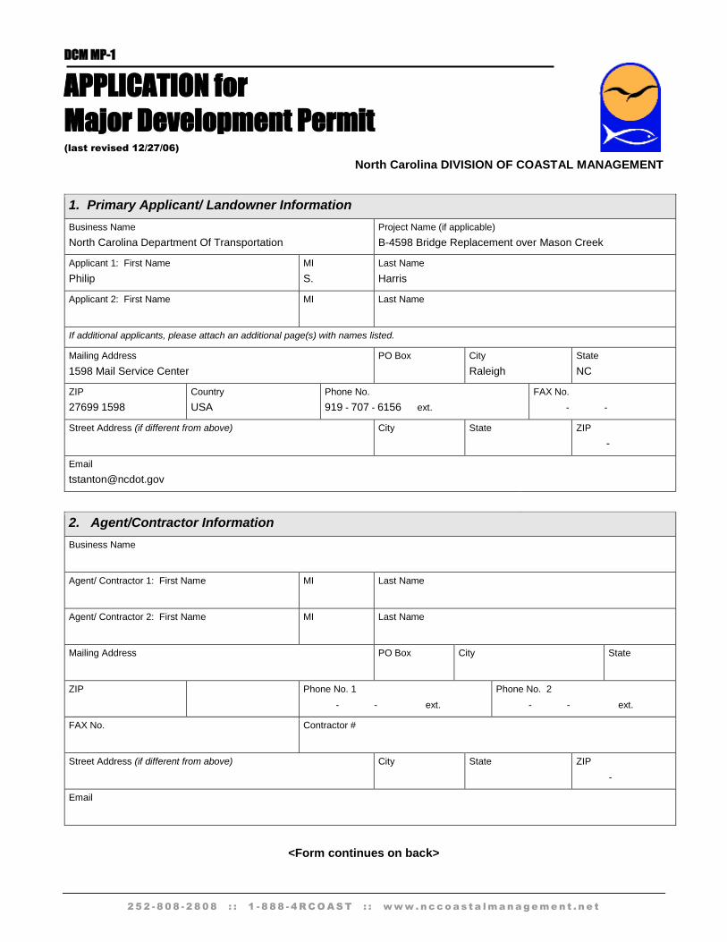
DCM MP-1
APPLICATION for
Major Development Permit (last revised 12/27/06)
North Carolina DIVISION OF COASTAL MANAGEMENT
1. Primary Applicant/ Landowner Information
Business Name
North Carolina Department Of Transportation
Project Name (if applicable)
B-4598 Bridge Replacement over Mason Creek
Applicant 1: First Name
Philip
MI
S.
Last Name
Harris
Applicant 2: First Name
MI
Last Name
If additional applicants, please attach an additional page(s) with names listed.
Mailing Address
1598 Mail Service Center
PO Box
City
Raleigh
State
NC
ZIP
27699 1598
Country
USA
Phone No.
919 - 707 - 6156 ext.
FAX No.
- -
Street Address (if different from above)
City
State
ZIP
-
2. Agent/Contractor Information
Business Name
Agent/ Contractor 1: First Name
MI
Last Name
Agent/ Contractor 2: First Name
MI
Last Name
Mailing Address
PO Box
City
State
ZIP
Phone No. 1
- - ext.
Phone No. 2
- - ext.
FAX No.
Contractor #
Street Address (if different from above)
City
State
ZIP
-
<Form continues on back>
Form DCM MP-1 (Page 2 of 5) APPLICATION for
Major Development Permit
2 5 2 - 8 0 8 - 2 8 0 8 : : 1 - 8 8 8 - 4 R C O A S T : : w w w . n c c o a s t a l m a n a g e m e n t . n e t
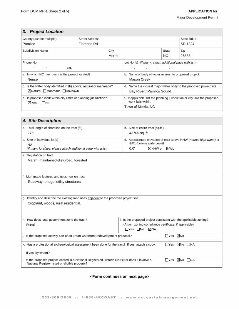
3. Project Location
County (can be multiple)
Pamlico
Street Address
Florence Rd
State Rd. #
SR 1324
Subdivision Name
City
Merritt
State
NC
Zip
28556 -
Phone No.
- - ext.
Lot No.(s) (if many, attach additional page with list)
, , , ,
a. In which NC river basin is the project located?
Neuse
b. Name of body of water nearest to proposed project
Mason Creek
c. Is the water body identified in (b) above, natural or manmade?
Natural Manmade Unknown
d. Name the closest major water body to the proposed project site.
Bay River / Pamlico Sound
e. Is proposed work within city limits or planning jurisdiction?
Yes No
f. If applicable, list the planning jurisdiction or city limit the proposed work falls within.
Town of Merritt, NC
4. Site Description
a. Total length of shoreline on the tract (ft.)
275'
b. Size of entire tract (sq.ft.)
43705 sq. ft.
c. Size of individual lot(s)
NA, , , (If many lot sizes, please attach additional page with a list)
d. Approximate elevation of tract above NHW (normal high water) or NWL (normal water level)
0.0' NHW or NWL
e. Vegetation on tract
Marsh, maintained-disturbed, forested
f. Man-made features and uses now on tract
Roadway, bridge, utility structures
g. Identify and describe the existing land uses adjacent to the proposed project site.
Cropland, woods, rural residential.
h. How does local government zone the tract?
Rural
i. Is the proposed project consistent with the applicable zoning?
(Attach zoning compliance certificate, if applicable)
Yes No NA
j. Is the proposed activity part of an urban waterfront redevelopment proposal? Yes No
k. Has a professional archaeological assessment been done for the tract? If yes, attach a copy.
If yes, by whom?
Yes No NA
l. Is the proposed project located in a National Registered Historic District or does it involve a National Register listed or eligible property?
Yes No NA
<Form continues on next page>
Form DCM MP-1 (Page 3 of 5) APPLICATION for
Major Development Permit
2 5 2 - 8 0 8 - 2 8 0 8 : : 1 - 8 8 8 - 4 R C O A S T : : w w w . n c c o a s t a l m a n a g e m e n t . n e t
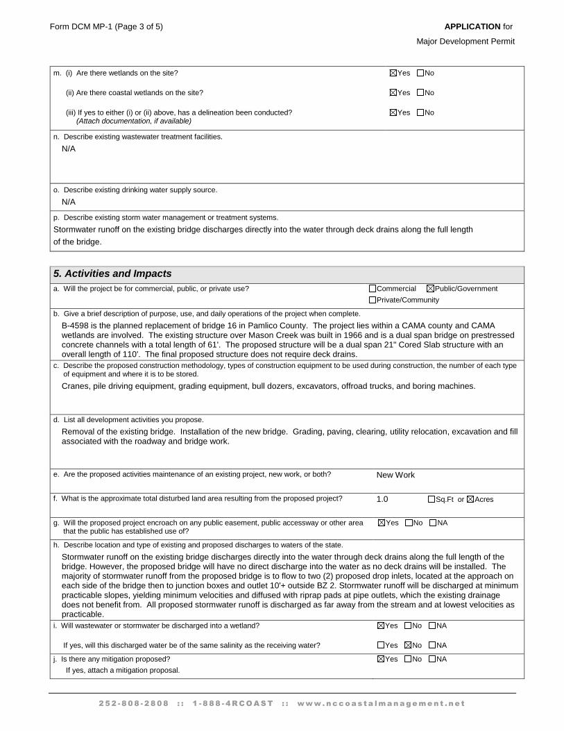
m. (i) Are there wetlands on the site?
(ii) Are there coastal wetlands on the site?
(iii) If yes to either (i) or (ii) above, has a delineation been conducted? (Attach documentation, if available)
Yes No
Yes No
Yes No
n. Describe existing wastewater treatment facilities.
N/A
o. Describe existing drinking water supply source.
N/A
p. Describe existing storm water management or treatment systems.
Stormwater runoff on the existing bridge discharges directly into the water through deck drains along the full length
of the bridge.
5. Activities and Impacts
a. Will the project be for commercial, public, or private use? Commercial Public/Government
Private/Community
b. Give a brief description of purpose, use, and daily operations of the project when complete.
B-4598 is the planned replacement of bridge 16 in Pamlico County. The project lies within a CAMA county and CAMA wetlands are involved. The existing structure over Mason Creek was built in 1966 and is a dual span bridge on prestressed concrete channels with a total length of 61'. The proposed structure will be a dual span 21" Cored Slab structure with an overall length of 110'. The final proposed structure does not require deck drains.
c. Describe the proposed construction methodology, types of construction equipment to be used during construction, the number of each type of equipment and where it is to be stored.
Cranes, pile driving equipment, grading equipment, bull dozers, excavators, offroad trucks, and boring machines.
d. List all development activities you propose.
Removal of the existing bridge. Installation of the new bridge. Grading, paving, clearing, utility relocation, excavation and fill associated with the roadway and bridge work.
e. Are the proposed activities maintenance of an existing project, new work, or both? New Work
f. What is the approximate total disturbed land area resulting from the proposed project? 1.0 Sq.Ft or Acres
g. Will the proposed project encroach on any public easement, public accessway or other area that the public has established use of?
Yes No NA
h. Describe location and type of existing and proposed discharges to waters of the state.
Stormwater runoff on the existing bridge discharges directly into the water through deck drains along the full length of the bridge. However, the proposed bridge will have no direct discharge into the water as no deck drains will be installed. The majority of stormwater runoff from the proposed bridge is to flow to two (2) proposed drop inlets, located at the approach on each side of the bridge then to junction boxes and outlet 10'+ outside BZ 2. Stormwater runoff will be discharged at minimum practicable slopes, yielding minimum velocities and diffused with riprap pads at pipe outlets, which the existing drainage does not benefit from. All proposed stormwater runoff is discharged as far away from the stream and at lowest velocities as practicable.
i. Will wastewater or stormwater be discharged into a wetland?
If yes, will this discharged water be of the same salinity as the receiving water?
Yes No NA
Yes No NA
j. Is there any mitigation proposed?
If yes, attach a mitigation proposal.
Yes No NA
Form DCM MP-1 (Page 4 of 5) APPLICATION for
Major Development Permit
<Fm·m-Gontinues on back>----
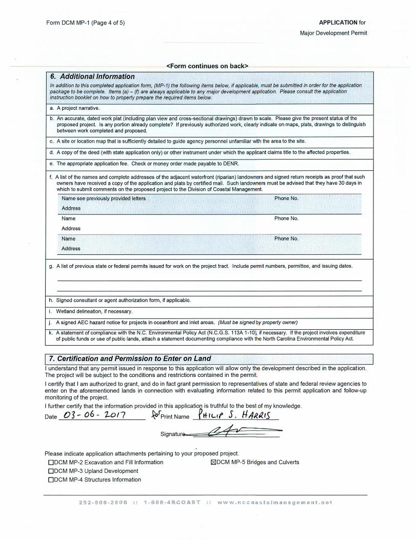
6. Additional Information In addition to this completed application form, (MP-1) the following items below, if applicable, must be submitted in order for the application package to be complete. Items (a) - (f) are always applicable to any major development application. Please consult the application instruction booklet on how to properly prepare the required items below.
' a. A project narrative.
b. An accurate, dated work plat (including plan view and cross-sectional drawings) drawn to scale. Please give the present status of the proposed project. Is any portion already complete? If previously authorized work, clearly indicate on maps, plats, drawings to distinguish between work completed and proposed.
c . A site or location map that is sufficiently detailed to guide agency personnel unfamiliar with the area to the site .
d. A copy of the deed (with state application only) or other instrument under which the applicant claims title to the affected properties.
e. The appropriate application fee . Check or money order made payable to DENR.
f. A list of the names and complete addresses of the adjacent waterfront (riparian) landowners and signed return receipts as proof that such owners have received a copy of the application and plats by certified mail. Such landowners must be advised that they have 30 days in which to submit comments on the proposed project to the Division of Coastal Management.
Name see previously provided letters Phone No.
Address
Name Phone No.
Address
" Name Phone No.
Address
g. A list of previous state or federal permits issued for work on the project tract. Include permit numbers, permittee, and issuing dates.
h. Signed consultant or agent authorization form, if applicable.
i. Wetland delineation, if necessary.
j. A signed AEC hazard notice for projects in oceanfront and inlet areas. (Must be signed by property owner)
k. A statement of compliance with the N.C. Environmental Policy Act (N.C.G.S. 113A 1-10), if necessary. If the project involves expenditure of public funds or use of publ ic lands, attach a statement documenting compl iance with the North Carolina Environmental Pol icy Act.
I 7. Certification and Permission to Enter on Land I understand that any permit issued in response to this application will allow only the development described in the application . The project will be subject to the conditions and restrictions contained in the permit.
I certify that I am authorized to grant, and do in fact grant permission to representatives of state and federa l review agencies to enter on the aforementioned lands in connection with evaluating information related to this permit application and follow-up monitoring of the project.
I further certify that the information provided in th is appl ication is truthful to the best of my knowledge.
Date 03- o6 - 1-ot? ~rPrint Name elf ILtf s. HJ/1?..2.15
Signaturs.e =::::::::::::~&~~iJ~~~~~~:::-
Please indicate application attachments pertaining to your proposed project.
ODCM MP-2 Excavation and Fi ll Information 181DCM MP-5 Bridges and Culverts
ODCM MP-3 Upland Development
ODCM MP-4 Structures Information

Form DCM MP-1 (Page 5 of 5) APPLICATION for
Major Development Permit
2 5 2 - 8 0 8 - 2 8 0 8 : : 1 - 8 8 8 - 4 R C O A S T : : w w w . n c c o a s t a l m a n a g e m e n t . n e t
252-808-2808 :: 1-888-4RCOAST :: www.nccoastalmanagement.net revised: 10/26/06
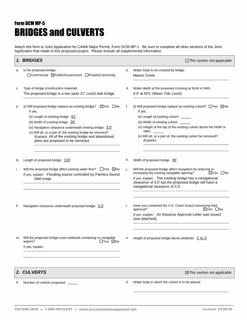
Form DCM MP-5
BRIDGES and CULVERTS
Attach this form to Joint Application for CAMA Major Permit, Form DCM MP-1. Be sure to complete all other sections of the Joint Application that relate to this proposed project. Please include all supplemental information.
1. BRIDGES This section not applicable
a. Is the proposed bridge:
Commercial Public/Government Private/Community
b. Water body to be crossed by bridge:
Mason Creek
c. Type of bridge (construction material):
The proposed bridge is a two span 21" cored slab bridge
d. Water depth at the proposed crossing at NLW or NWL:
4.5' at MTL (Mean Tide Level)
e. (i) Will proposed bridge replace an existing bridge? Yes No
If yes,
(ii) Length of existing bridge: 61'
(iii) Width of existing bridge: 26'
(iv) Navigation clearance underneath existing bridge: 3.0'
(v) Will all, or a part of, the existing bridge be removed?
(Explain) All of the existing bridge and abandoned piers are proposed to be removed.
f. (i) Will proposed bridge replace an existing culvert? Yes No
If yes,
(ii) Length of existing culvert:
(iii) Width of existing culvert:
(iv) Height of the top of the existing culvert above the NHW or
NWL:
(v) Will all, or a part of, the existing culvert be removed?
(Explain)
g. Length of proposed bridge: 110' h. Width of proposed bridge: 36'
i. Will the proposed bridge affect existing water flow? Yes No
If yes, explain: Flooding source controlled by Pamlico Sound tidal surge.
j. Will the proposed bridge affect navigation by reducing or increasing the existing navigable opening? Yes No
If yes, explain: The existing bridge has a navigational clearance of 3.0' but the proposed bridge will have a navigational clearance of 3.3'.
k. Navigation clearance underneath proposed bridge: 3.3' l. Have you contacted the U.S. Coast Guard concerning their approval? Yes No
If yes, explain: An Advance Approval Letter was issued (see attached).
m. Will the proposed bridge cross wetlands containing no navigable waters? Yes No
If yes, explain:
n. Height of proposed bridge above wetlands: 1' to 3'
2. CULVERTS This section not applicable
a. Number of culverts proposed: b. Water body in which the culvert is to be placed:
Form DCM MP-5 (Bridges and Culverts, Page 2 of 4)
252-808-2808 :: 1-888-4RCOAST :: www.nccoastalmanagement.net revised: 10/26/06
< Form continues on back>
c. Type of culvert (construction material):
d. (i) Will proposed culvert replace an existing bridge?
Yes No
If yes,
(ii) Length of existing bridge:
(iii) Width of existing bridge:
(iv) Navigation clearance underneath existing bridge:
(v) Will all, or a part of, the existing bridge be removed?
(Explain)
e. (i) Will proposed culvert replace an existing culvert?
Yes No
If yes,
(ii) Length of existing culvert(s):
(iii) Width of existing culvert(s):
(iv) Height of the top of the existing culvert above the NHW or
NWL:
(v) Will all, or a part of, the existing culvert be removed?
(Explain)
f. Length of proposed culvert: g. Width of proposed culvert:
h. Height of the top of the proposed culvert above the NHW or NWL.
i. Depth of culvert to be buried below existing bottom contour.
j. Will the proposed culvert affect navigation by reducing or increasing the existing navigable opening? Yes No
If yes, explain:
k. Will the proposed culvert affect existing water flow?
Yes No
If yes, explain:
3. EXCAVATION and FILL This section not applicable
a. (i) Will the placement of the proposed bridge or culvert require any excavation below the NHW or NWL? Yes No
If yes,
(ii) Avg. length of area to be excavated:
(iii) Avg. width of area to be excavated:
(iv) Avg. depth of area to be excavated:
(v) Amount of material to be excavated in cubic yards:
b. (i) Will the placement of the proposed bridge or culvert require any excavation within coastal wetlands/marsh (CW), submerged aquatic vegetation (SAV), shell bottom (SB), or other wetlands (WL)? If any boxes are checked, provide the number of square feet affected.
CW 259 s.f. SAV SB
WL None
(ii) Describe the purpose of the excavation in these areas:
Excavation was recquired for the spill through abutment.
c. (i) Will the placement of the proposed bridge or culvert require any high-ground excavation? Yes No
If yes,
(ii) Avg. length of area to be excavated: 45 ft
(iii) Avg. width of area to be excavated: 28 ft
(iv) Avg. depth of area to be excavated: 3ft
(v) Amount of material to be excavated in cubic yards: 170 cy
Form DCM MP-5 (Bridges and Culverts, Page 3 of 4)
252-808-2808 :: 1-888-4RCOAST :: www.nccoastalmanagement.net revised: 10/26/06
d. If the placement of the bridge or culvert involves any excavation, please complete the following:
(i) Location of the spoil disposal area: TBD by contractor; however, excavated soil will likely be stored under proposed roadbed and used for roadbed fill or removed for off-site storage on high ground.
(ii) Dimensions of the spoil disposal area: N/A
(iii) Do you claim title to the disposal area? Yes No (If no, attach a letter granting permission from the owner.)
(iv) Will the disposal area be available for future maintenance? Yes No
(v) Does the disposal area include any coastal wetlands/marsh (CW), submerged aquatic vegetation (SAVs), other wetlands (WL), or shell bottom (SB)?
CW SAV WL SB None
If any boxes are checked, give dimensions if different from (ii) above.
(vi) Does the disposal area include any area below the NHW or NWL? ? Yes No
If yes, give dimensions if different from (ii) above.
e. (i) Will the placement of the proposed bridge or culvert result in any fill (other than excavated material described in Item d above) to be placed below NHW or NWL? Yes No
If yes,
(ii) Avg. length of area to be filled:
(iii) Avg. width of area to be filled:
(iv) Purpose of fill: There are fourteen proposed 12'' x 12'' concrete piles at interior bent.
f. (i) Will the placement of the proposed bridge or culvert result in any fill (other than excavated material described in Item d above) to be placed within coastal wetlands/marsh (CW), submerged aquatic vegetation (SAV), shell bottom (SB), or other wetlands (WL)? If any boxes are checked, provide the number of square feet affected.
CW 4125 s.f. SAV SB
WL None
(ii) Describe the purpose of the excavation in these areas:
To construct roadway embankment.
g. (i) Will the placement of the proposed bridge or culvert result in any fill (other than excavated material described in Item d above) to be placed on high-ground? Yes No
If yes,
(ii) Avg. length of area to be filled: 465 ft
(iii) Avg. width of area to be filled: 45 ft
(iv) Purpose of fill: To construct roadway embankment.
4. GENERAL
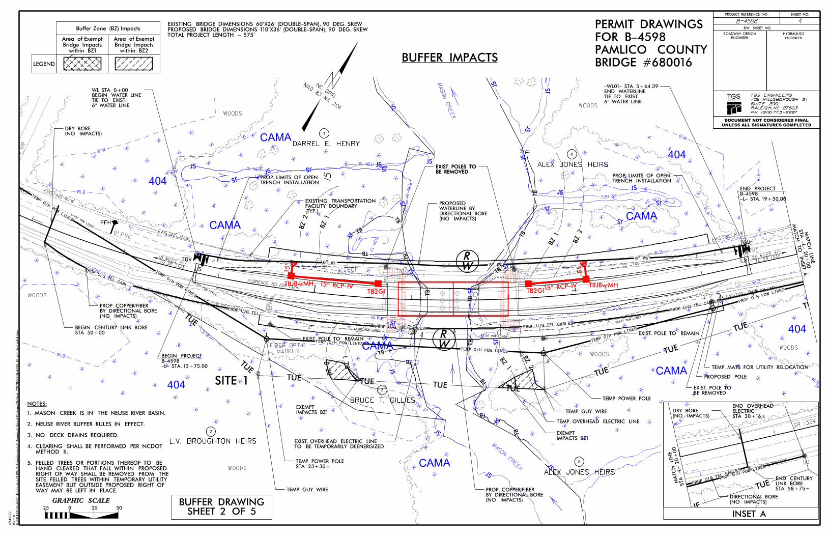
a. Will the proposed project require the relocation of any existing utility lines? Yes No
If yes, explain: Water line, power line, fiber optic, copper (telephone). See attached Utility Plans
If this portion of the proposed project has already received approval from local authorities, please attach a copy of the approval or certification.
b. Will the proposed project require the construction of any temporary detour structures? Yes No
If yes, explain:
< Form continues on back>
Form DCM MP-5 (Bridges and Culverts, Page 4 of 4)
c. Will the proposed project require any work channels?
DYes [81No
If yes, complete Form DCM-MP-2.
e. What type of construction equipment will be used (for example, dragline, backhoe, or hydraulic dredge)?
Cranes, pile driving equipment, grading equipment, bull dozers, excavators, offroad trucks, and boring machines.
g. Will the placement of the proposed bridge or culvert require any shoreline stabilization? DYes [81No
If yes, complete form MP-2, Section 3 for Shoreline Stabilization only.
Project Name
NC Department of Transportation
----..+----""' Applicant S1g ature
d. How will excavated or fill material be kept on site and erosion controlled?
NCDOT Design Standards in Sensitive Watersheds will be implemented during project construction
f. Will wetlands be crossed in transporting equipment to project site?
[81Yes DNo
If yes, explain steps that will be taken to avoid or minimize environmental impacts.
Crane Mats used to reach temporary power lines.
Commander Homeland Security ~ · ~ U.S. Department o~· United States Coast Guard
Fifth Coast Guard District
431 Crawford Street Portsmouth, VA 23704-5004 Staff Symbol: (dpb)
United States Coast Guard
Mr. Phil S. Harris, III, P.E. North Carolina Department of Transportation Natural Environment Section 1598 Mail Service Center Raleigh, NC 27699-1598
Dear Mr. Harris:
Phone: (757) 398-6587 Fax: (757) 398-6334 Email: Mickey.D.Sanders2@uscq .mil Or [email protected]
16590 13 DEC 2016
liD) rn © ~ o \vrL2 HI:-
1Jll . DEC 1 9 • ~
~~FICE Of NATURAL ENVIRONM ~NT
Coast Guard revie'v of your proposed project as provided in your email dated November 17, 2016, is complete.
Based on the documentation provided and our research, it is determined that a Coast Guard bridge permit will not be required for the proposed new bridge construction on S.R. 1324 (Florence Road) across Mason Creek, at Pamlico, NC.
The project will be placed in our Advance Approval category as per Title 33 Code of Federal Regulations Part 115.70. This Advance Approval determination is for the location and structure described above and is valid for five years from the date of this letter. If the construction project does not commence within this time period, you must contact this office for reaffirmation of this authorization. Future bridge projects along the same waterway will have to be independently evaluated before they may be considered for placement in the Advance Approval category.
The fact that a Coast Guard bridge permit is not required does not relieve you of the responsibility for compliance with the requirements of any other Federal, State, or local agency who may have jurisdiction over any aspect of the project. Although the project will not require a bridge permit, other areas of Coast Guard jurisdiction apply. The following must be met:
a. You or your contractor must notify this office at least 30 days in advance ofthe start of construction and any other work which may be an obstruction to navigation, so we may issue and update the information in our Local Notice to Mariners and monitor the project.
b. At no time during the project will the waterway be closed to navigation without the prior notification and approval of the Coast Guard.
c. The lowest portion of the superstructure of the bridge across the waterway should clear the 100-year flood height elevation, if feasible.
d. In addition, the requirement to display navigational lighting at the aforementioned bridge is hereby waived, as per Title 33 Code ofFederal Regulations, Part 118.40(b). This waiver may be rescinded at anytime in the future should nighttime navigation through the proposed bridge be increased to a level determined by the District Commander to warrant lighting.
16590 13 DEC 2016
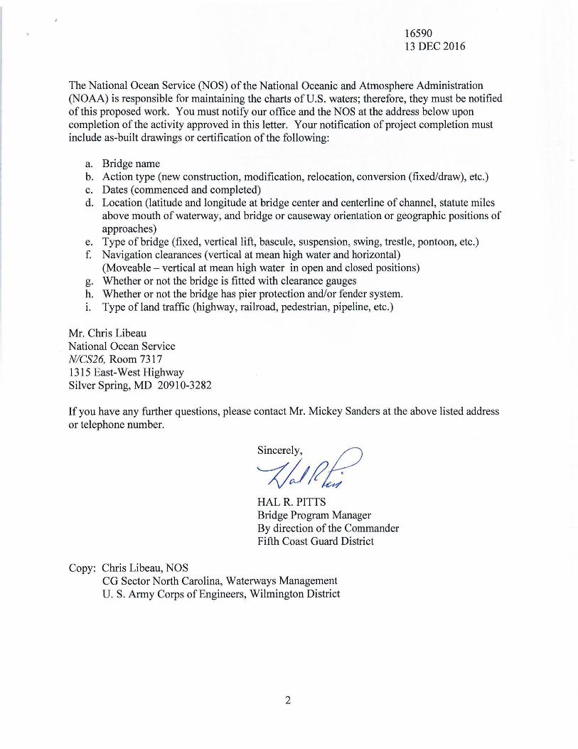
The National Ocean Service (NOS) of the National Oceanic and Atmosphere Administration (NOAA) is responsible for maintaining the charts of U.S. waters; therefore, they must be notified of this proposed work. You must notify our office and the NOS at the address below upon completion of the activity approved in this letter. Your notification of project completion must include as-built drawings or certification of the following:
a. Bridge name b. Action type (new construction, modification, relocation, conversion (fixed/draw), etc.) c. Dates (commenced and completed) d. Location (latitude and longitude at bridge center and centerline of channel, statute miles
above mouth of waterway, and bridge or causeway orientation or geographic positions of approaches)
e. Type of bridge (fixed, vertical lift, bascule, suspension, swing, trestle, pontoon, etc.) f. Navigation clearances (vertical at mean high water and horizontal)
(Moveable - vertical at mean high water in open and closed positions) g. Whether or not the bridge is fitted with clearance gauges h. Whether or not the bridge has pier protection and/or fender system. 1. Type of land traffic (highway, railroad, pedestrian, pipeline, etc.)
Mr. Chris Libeau National Ocean Service NICS26, Room 7317 1315 East-West Highway Silver Spring, MD 20910-3282
If you have any further questions, please contact Mr. Mickey Sanders at the above listed address or telephone number.
Copy: Chris Libeau, NOS
~~~P HAL R. PITTS Bridge Program Manager By direction of the Commander Fifth Coast Guard District
CG Sector North Carolina, Waterways Management U. S. Army Corps of Engineers, Wilmington District
2
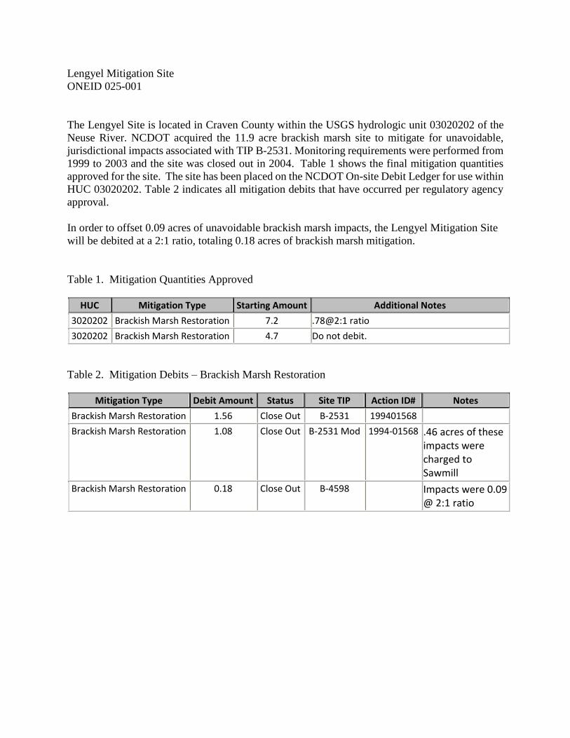
Lengyel Mitigation Site
ONEID 025-001
The Lengyel Site is located in Craven County within the USGS hydrologic unit 03020202 of the
Neuse River. NCDOT acquired the 11.9 acre brackish marsh site to mitigate for unavoidable,
jurisdictional impacts associated with TIP B-2531. Monitoring requirements were performed from
1999 to 2003 and the site was closed out in 2004. Table 1 shows the final mitigation quantities
approved for the site. The site has been placed on the NCDOT On-site Debit Ledger for use within
HUC 03020202. Table 2 indicates all mitigation debits that have occurred per regulatory agency
approval.
In order to offset 0.09 acres of unavoidable brackish marsh impacts, the Lengyel Mitigation Site
will be debited at a 2:1 ratio, totaling 0.18 acres of brackish marsh mitigation.
Table 1. Mitigation Quantities Approved
HUC Mitigation Type Starting Amount Additional Notes
3020202 Brackish Marsh Restoration 7.2 .78@2:1 ratio
3020202 Brackish Marsh Restoration 4.7 Do not debit.
Table 2. Mitigation Debits – Brackish Marsh Restoration
Mitigation Type Debit Amount Status Site TIP Action ID# Notes
Brackish Marsh Restoration 1.56 Close Out B-2531 199401568
Brackish Marsh Restoration 1.08 Close Out B-2531 Mod 1994-01568 .46 acres of these impacts were charged to Sawmill
Brackish Marsh Restoration 0.18 Close Out B-4598 Impacts were 0.09 @ 2:1 ratio
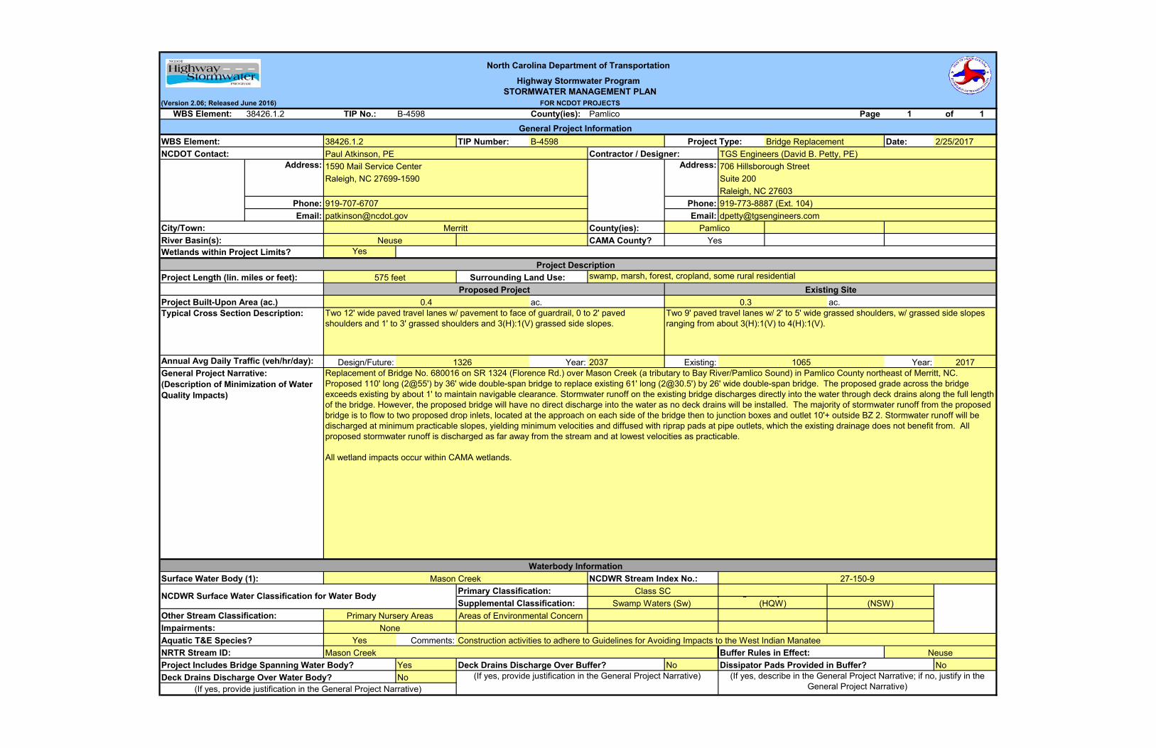
(Version 2.06; Released June 2016)38426.1.2 TIP No.: B-4598 County(ies): Pamlico Page 1 of 1
TIP Number: Date:
Phone: Phone:Email: Email:
County(ies):CAMA County?
Yes
Design/Future: Year: 2037 Existing: Year:
Aquatic T&E Species? Yes Comments:
Yes NoNo
(If yes, provide justification in the General Project Narrative)
Project Includes Bridge Spanning Water Body? Deck Drains Discharge Over Buffer? Dissipator Pads Provided in Buffer? NoDeck Drains Discharge Over Water Body? (If yes, provide justification in the General Project Narrative) (If yes, describe in the General Project Narrative; if no, justify in the
General Project Narrative)
NRTR Stream ID:
Annual Avg Daily Traffic (veh/hr/day):
Existing SiteProject Length (lin. miles or feet):
ac.
Surface Water Body (1):
NCDWR Surface Water Classification for Water Body
ac.
NeuseBuffer Rules in Effect:
None
Waterbody Information
2017
NCDWR Stream Index No.:Mason Creek
Impairments:
(NSW)Other Stream Classification:
Primary Classification:
Project Built-Upon Area (ac.)
Areas of Environmental Concern
River Basin(s):
North Carolina Department of TransportationHighway Stormwater Program
STORMWATER MANAGEMENT PLAN FOR NCDOT PROJECTS
Project Type:
Address:
General Project InformationB-4598
WBS Element:
WBS Element:NCDOT Contact: Contractor / Designer:
Address:
Bridge Replacement
Suite 200Raleigh, NC 27603
38426.1.2TGS Engineers (David B. Petty, PE)
Primary Nursery Areas
City/Town:
0.4Typical Cross Section Description:
Surrounding Land Use:
General Project Narrative:(Description of Minimization of Water Quality Impacts)
Yes
0.3
Supplemental Classification: Swamp Waters (Sw) g y
(HQW)
Wetlands within Project Limits?
Construction activities to adhere to Guidelines for Avoiding Impacts to the West Indian ManateeMason Creek
2/25/2017
Pamlico
Paul Atkinson, PE1590 Mail Service CenterRaleigh, NC 27699-1590
Class SC
706 Hillsborough Street
919-773-8887 (Ext. 104)[email protected]
Project Description
Proposed Project
Neuse
575 feet
Merritt
swamp, marsh, forest, cropland, some rural residential
1326 1065
27-150-9
Replacement of Bridge No. 680016 on SR 1324 (Florence Rd.) over Mason Creek (a tributary to Bay River/Pamlico Sound) in Pamlico County northeast of Merritt, NC. Proposed 110' long (2@55') by 36' wide double-span bridge to replace existing 61' long ([email protected]') by 26' wide double-span bridge. The proposed grade across the bridge exceeds existing by about 1' to maintain navigable clearance. Stormwater runoff on the existing bridge discharges directly into the water through deck drains along the full length of the bridge. However, the proposed bridge will have no direct discharge into the water as no deck drains will be installed. The majority of stormwater runoff from the proposed bridge is to flow to two proposed drop inlets, located at the approach on each side of the bridge then to junction boxes and outlet 10'+ outside BZ 2. Stormwater runoff will be discharged at minimum practicable slopes, yielding minimum velocities and diffused with riprap pads at pipe outlets, which the existing drainage does not benefit from. All proposed stormwater runoff is discharged as far away from the stream and at lowest velocities as practicable.
All wetland impacts occur within CAMA wetlands.
Two 9' paved travel lanes w/ 2' to 5' wide grassed shoulders, w/ grassed side slopes ranging from about 3(H):1(V) to 4(H):1(V).
Two 12' wide paved travel lanes w/ pavement to face of guardrail, 0 to 2' paved shoulders and 1' to 3' grassed shoulders and 3(H):1(V) grassed side slopes.
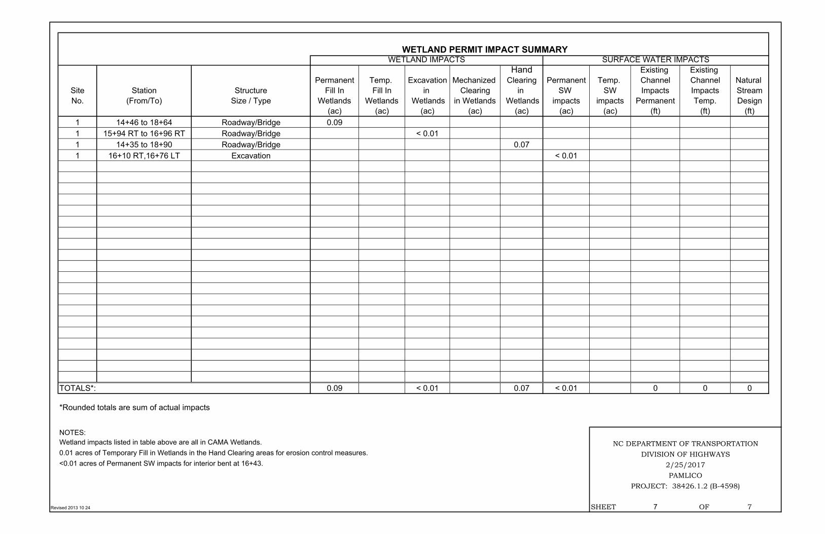
Hand Existing Existing Permanent Temp. Excavation Mechanized Clearing Permanent Temp. Channel Channel Natural
Site Station Structure Fill In Fill In in Clearing in SW SW Impacts Impacts StreamNo. (From/To) Size / Type Wetlands Wetlands Wetlands in Wetlands Wetlands impacts impacts Permanent Temp. Design
(ac) (ac) (ac) (ac) (ac) (ac) (ac) (ft) (ft) (ft)1 14+46 to 18+64 Roadway/Bridge 0.09 1 15+94 RT to 16+96 RT Roadway/Bridge < 0.01 1 14+35 to 18+90 Roadway/Bridge 0.07 1 16+10 RT,16+76 LT Excavation < 0.01
TOTALS*: 0.09 < 0.01 0.07 < 0.01 0 0 0
*Rounded totals are sum of actual impacts
NOTES:
Revised 2013 10 24 SHEET 7 OF 7
Wetland impacts listed in table above are all in CAMA Wetlands.0.01 acres of Temporary Fill in Wetlands in the Hand Clearing areas for erosion control measures.<0.01 acres of Permanent SW impacts for interior bent at 16+43.
WETLAND PERMIT IMPACT SUMMARYWETLAND IMPACTS SURFACE WATER IMPACTS
PAMLICOPROJECT: 38426.1.2 (B-4598)
NC DEPARTMENT OF TRANSPORTATIONDIVISION OF HIGHWAYS
2/25/2017
ROAD CROSSING BRIDGE
PARALLEL IMPACT
ZONE 1 (ft2)
ZONE 2 (ft2)
TOTAL (ft2)
ZONE 1 (ft2)
ZONE 2 (ft2)
TOTAL (ft2)
ZONE 1 (ft2)
ZONE 2 (ft2)
1 Bridge L 15+86 to 17+00 X 724 98 822
1 Roadway L 14+83 to 17+58 X 1802 1083 2885
TOTAL: 2526.0 1181.0 3707.0 0.0 0.0 0.0
NOTES:
SHEET 4 OF 5
PROJECT: 38426.1.2 (B-4598)
2/25/2017
N.C. DEPT. OF TRANSPORTATIONDIVISION OF HIGHWAYS
PAMLICO COUNTY
IMPACT
BUFFER IMPACTS SUMMARY
TYPE
SITE NO.STRUCTURE SIZE /
TYPESTATION
(FROM/TO)
ALLOWABLE MITIGABLEBUFFER
REPLACEMENT
Rev. May 2006
ZONE 1 (ft2)
ZONE 2 (ft2)
1 L 14+83 to 17+58 1983 921
TOTAL: 1983 921
NOTES:
WETLANDS IN BUFFERS
SITE NO.STATION
(FROM/TO)
WETLANDS IN BUFFER IMPACTS SUMMARY
SHEET 5 OF 5
PROJECT: 38426.1.2 (B-4598)
2/25/2017
N.C. DEPT. OF TRANSPORTATIONDIVISION OF HIGHWAYS
PAMLICO COUNTY
Rev. Jan 2009
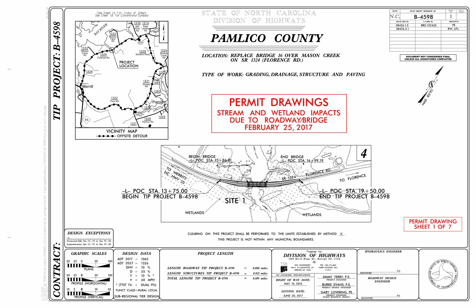
B-4598- ENVIROMENTAL NARRATIVE
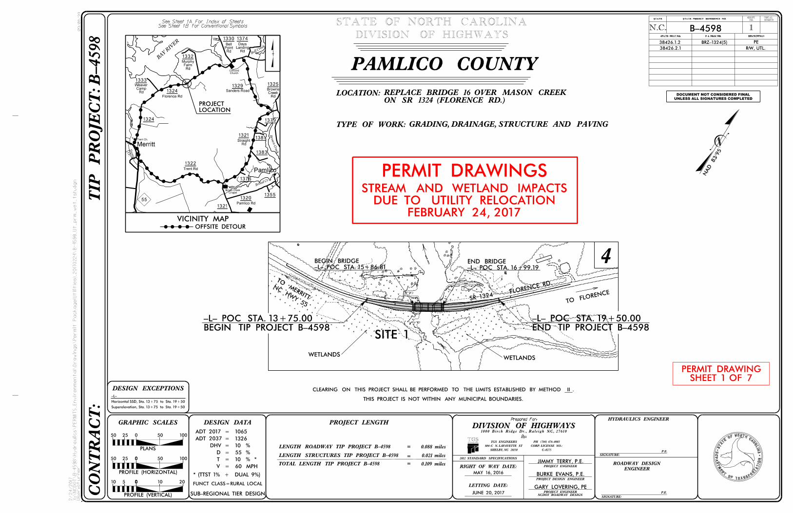
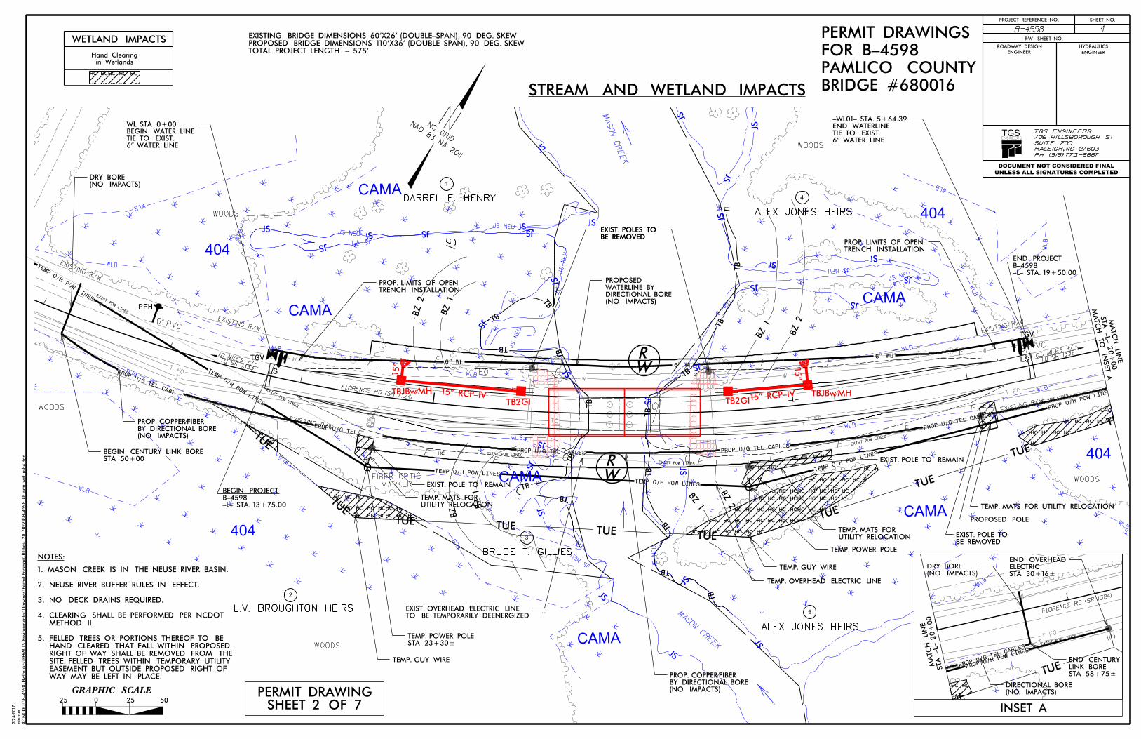
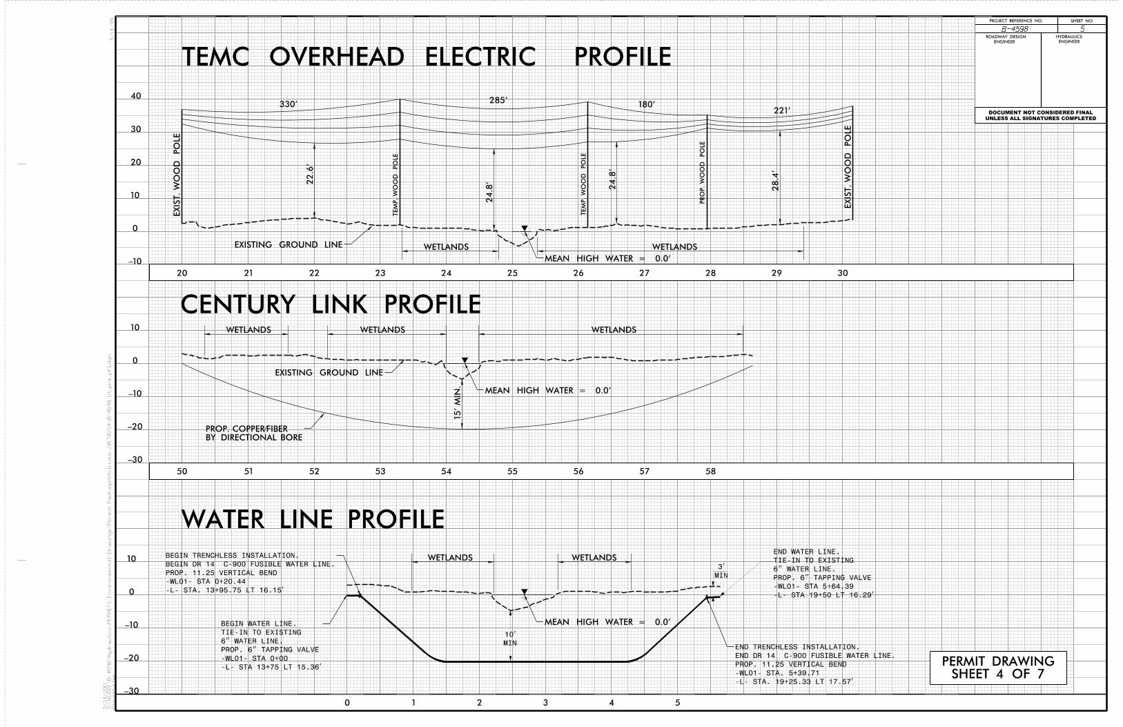
Utility Owners Water- Al Gerard, Field Operations Manager Pamlico County Water System Pamlico County, N.C. (252)745-5453 [email protected] Century Link-Phone- Mitch Averitte 311 Hancock St. New Bern NC 28560 252-636-6620. [email protected]> Power- John Marsh Senior Staking Technician Tideland Electric Membership Corporation P O Box 38, Grantsboro, NC 28529 252-637-8314 / 1-800-637-1079 x4324 [email protected] www.tidelandemc.com General Utility Relocation: All utility lines inside the project limits currently within the construction limits will be adjusted or relocated as necessary before the project Let Date.
Power Tideland EMC- John Marsh stated there are two poles on the east side of the bridge that will be moved back 15' to accommodate crane clearance. In addition one pole to the north of these poles will be moved to eliminate pull and the need for a side guy. A 15' wide TUE will be needed from the center of the poles on each side. It is recommended that the trees cut for clearing be left where they fall as there will be no other work in this area by any other contractors. This would leave a minimum impact on the wetland areas. All clearing will be with non-mechanized means. The existing poles will be left in place. At the completion of the bridge replacement the lines can be transferred back to the existing poles, as the proposed poles will be unreachable by a pole truck should an outage or maintenance be required. All pole placement inside the wetland areas will be accomplished with the use of matts. There will be minimum impact to environmentally sensitive areas due to the non-mechanized clearing and the use of matts.
Telephone Century Link/Embarq- Mitch Averitte, stated that Century Link/Embarq has facilities in conflict. Relocation of the telephone facilities will be accomplished with a 4" directional drill. The proposed cables will be placed inside of the 4" plastic pipe pulled back with the directional drill. There are (2) buried copper cables on the right side of SR1324 (Florence Road) and (1) buried copper on the left side of SR1324 (Florence Road). This one buried copper crosses -L- at station 15+75 and transitions to an aerial crossing. This aerial crossing and all buried cables inside of the project limits will be replaced with (2) copper and (1) fiber optic cable. The relocated cables will be placed/relocated by directional drill. The bore entry will begin at station 13+75 RT-L to 19+50 RT-L. As outlined in the bore profile the bore will be a minimum of 15' below the stream bottom of Mason Creek. There will be no impact to environmentally sensitive areas due to the buried cable relocation because all trenching will take place in the roadway fill. All telephone lines constructed in wetlands, streams, and buffer zones will be by directional drill. Water Pamlico County Water- Al Gerard-, it has been determined there will be a conflict with the water line. Pamlico County Water requested the NCDOT handle the design, specifications, surveying, construction, inspection, ie., and all permitting required to relocate the existing water main located at the waterway crossing on Florence Road in Pamlico County. An existing 6” water line on the left side of SR1324 (Florence Road) will be replaced in kind by a new section of 6” water line. The relocated water line will be constructed by directional drill. The directional drill will begin approximately 25’ after the start of the project in the roadway fill and end approximately 25’ before the end of the project in the roadway fill. This bore will be a minimum of 10' below the stream bottom of Mason's Creek. There will be no impact to environmentally sensitive areas due to the water line because all trenching will take place in the roadway fill. All water line constructed in wetlands, streams, and buffer zones will be by directional drill. Cutoff valves will be provided on each side of the stream.
Summary of Environmental Impacts Based on the preliminary relocation plans provided by the power and telephone companies, there appears to be minimum impacts. The proposed directional bores will enter and exit as such with minimum impacts. Silt fence and all proper erosion control measures will be required and implemented. Any proposed telephone splice pits will be outside of the wetland boundaries. Hand clearing is typically expected in the wetlands and required for most buffer impacts. In addition mats can be placed as well to further minimize impacts.
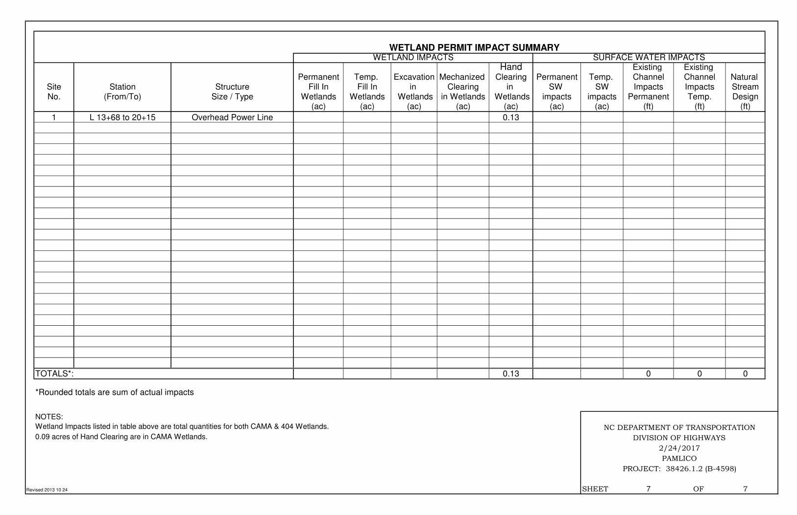
Hand Existing Existing Permanent Temp. Excavation Mechanized Clearing Permanent Temp. Channel Channel Natural
Site Station Structure Fill In Fill In in Clearing in SW SW Impacts Impacts StreamNo. (From/To) Size / Type Wetlands Wetlands Wetlands in Wetlands Wetlands impacts impacts Permanent Temp. Design
(ac) (ac) (ac) (ac) (ac) (ac) (ac) (ft) (ft) (ft)
1 L 13+68 to 20+15 Overhead Power Line 0.13
TOTALS*: 0.13 0 0 0
*Rounded totals are sum of actual impacts
NOTES:
Revised 2013 10 24 SHEET 7 OF 7
Wetland Impacts listed in table above are total quantities for both CAMA & 404 Wetlands.
0.09 acres of Hand Clearing are in CAMA Wetlands.
WETLAND PERMIT IMPACT SUMMARY
WETLAND IMPACTS SURFACE WATER IMPACTS
PAMLICO
PROJECT: 38426.1.2 (B-4598)
NC DEPARTMENT OF TRANSPORTATION
DIVISION OF HIGHWAYS
2/24/2017
ROAD CROSSING BRIDGE
PARALLEL IMPACT
ZONE 1 (ft2)
ZONE 2 (ft2)
TOTAL (ft2)
ZONE 1 (ft2)
ZONE 2 (ft2)
TOTAL (ft2)
ZONE 1 (ft2)
ZONE 2 (ft2)
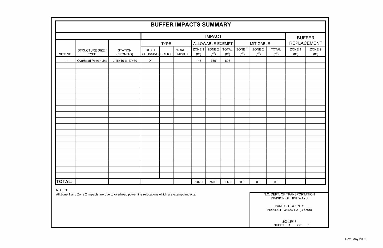
1 Overhead Power Line L 15+19 to 17+30 X 146 750 896
TOTAL: 146.0 750.0 896.0 0.0 0.0 0.0
NOTES:All Zone 1 and Zone 2 impacts are due to overhead power line relocations which are exempt impacts.
IMPACT
BUFFER IMPACTS SUMMARY
TYPE
SITE NO.STRUCTURE SIZE /
TYPESTATION
(FROM/TO)
ALLOWABLE EXEMPT MITIGABLEBUFFER
REPLACEMENT
SHEET 4 OF 5
PROJECT: 38426.1.2 (B-4598)
2/24/2017
N.C. DEPT. OF TRANSPORTATIONDIVISION OF HIGHWAYS
PAMLICO COUNTY
Rev. May 2006
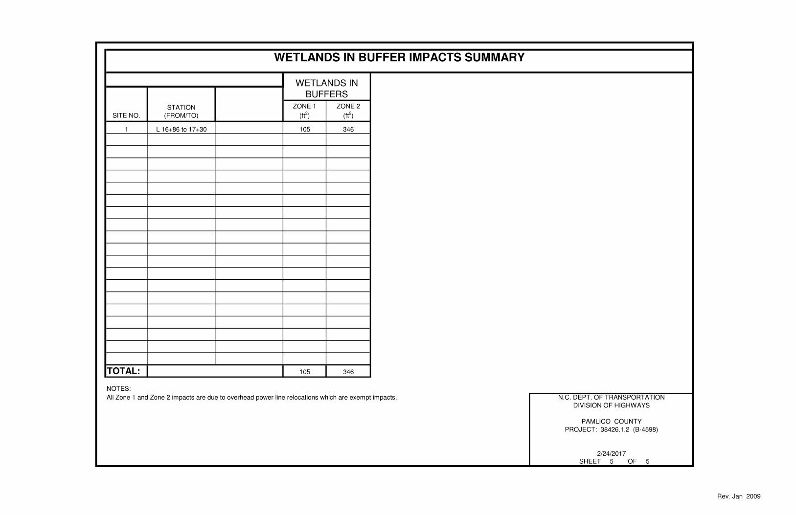
ZONE 1
(ft2)
ZONE 2
(ft2)
1 L 16+86 to 17+30 105 346
TOTAL: 105 346
NOTES:
All Zone 1 and Zone 2 impacts are due to overhead power line relocations which are exempt impacts.
WETLANDS IN
BUFFERS
SITE NO.
STATION
(FROM/TO)
WETLANDS IN BUFFER IMPACTS SUMMARY
SHEET 5 OF 5
PROJECT: 38426.1.2 (B-4598)
2/24/2017
N.C. DEPT. OF TRANSPORTATION
DIVISION OF HIGHWAYS
PAMLICO COUNTY
Rev. Jan 2009