Embed Size (px)
Citation preview

EENNVVIIRROONNMMEENNTTAALL IIMMPPAACCTT AASSSSEESSSSMMEENNTT ((EEIIAA)) FFOORR
EEGGYYPPTTIIAANN OOIILL && GGAASS AACCTTIIVVIITTIIEESS
SSUUBBMMIITTTTEEDD TTOO OOVVEERRSSEEAASS PPRRIIVVAATTEE IINNVVEESSTTMMEENNTT CCOORRPPOORRAATTIIOONN ((OOPPIICC))
PPRREEPPAARREEDD BBYY
FFiirreebbiirrdd
DDEEVVEELLOOPPMMEENNTT IINNCC.
FFEEBBRRUUAARRYY 22000044
Egypt Companies

CONTENTS
Introduction
1. Project Description
1.1 Apache Concessions 1.3
2. Environmental Baseline Conditions
2.1 Area 1 2.3
2.2 Area 2 2.12
2.3 Area 3 2.27
3. Potential Environmental Impacts & Mitigations
3.1 Impacts from Onshore Drilling Activities 3.2
3.2 Impacts from Pipeline Installation 3.14
3.3 Impacts from Gas Plant Construction and Operation 3.17
4. Appendices
A. Maps
B. Photos
C. Wellsite Footprint
D. EH&S Documents

Introduction

APACHE EGYPT COMPANIES Environmental Impact Assessment Oil & Gas Activities
Introduction, Prepared by FIREBIRD, February 2004 2
This report contains the environmental assessment of a number of activities that reflect
Apache’s oil and gas operations inside Egypt. Complete details are available in the
individual EIA reports that Apache has prepared for each activity. These reports have
been submitted, as a reference, to OPIC as part of this submittal.
It should be noted that in October, 2002, Apache submitted to OPIC a full EIA report
specifically covering its West Mediterranean deepwater development. This report,
which has been posted on OPIC’s website, describes a variety of activities including
drilling new offshore wells, completing old wells, tie-in pipelines, onshore production
facility (Gas Plant), and transferring the produced sales gas to existing facilities.
Apache Overall Operations Egypt is one of Apache Corporation’s most important international regions, and its
estimated proved reserves in Egypt constitute 10.4 percent of Apache's total estimated
proved reserves. Through December 31, 2003, the investments of the Apache Egypt
Companies in Egypt total approximately US $2.1 billion.
Apache and its affiliated companies (“Apache”) have a significant operating presence in
Egypt. As of December 31, 2003, Apache held interests in 10.2 million acres in Egypt
and is the number one producer of oil/condensate and the number two producer of
natural gas in the Western Desert. Apache’s total production ranks number three for all
of Egypt and accounts for 14% of Egypt’s total production. In addition Apache is the
most active driller with 20 drilling/completion rigs operating.
Apache owns a 75 percent interest in the Qarun Concession and a 100 percent interest
in the Khalda/Khalda Offset Concession, located in the Western Desert of Egypt. The
operating interest in Qarun was acquired from Phoenix Resources in 1996. In addition
to the Qarun and Khalda/Khalda Offset Concessions, Apache holds interests in the
East Beni Suef Concession to the south of the Qarun Concession, WD-19 Concession
to the north of Qarun, and four other blocks in the Western Desert the Matruh
Development Lease, the North East Abu Gharadig Concession (NEAG), the East
Bahariya Concession, and the West Mediterranean Block I (partly onshore and partly
offshore).

APACHE EGYPT COMPANIES Environmental Impact Assessment Oil & Gas Activities
Introduction, Prepared by FIREBIRD, February 2004 3
In 2001, Apache acquired all of Repsol's interest in the Khalda Concession, the Ras
Kanayes Concession, the Ras El Hekma Concession, the North East Abu Gharadig
Concession and the portion of the West Mediterranean Concession onshore and
offshore up to 100 meters water depth. Included in the transaction was Repsol's
interest in the Umbarka Development Lease, and in the South Umbarka Concession.
Apache has become operator of all these areas except North East Abu Gharadig.
Pursuant to the terms of the concession agreements, Qarun Petroleum Company
(QPC) and Khalda Petroleum Company (KPC) have been formed as joint venture
companies between the contractor (Apache and its partners, if any) and the Egyptian
General Petroleum Corporation (EGPC) to conduct development activities in each
concession. Additional joint venture companies exist under each concession where
production has been established in name only and are actually managed by either QPC
or KPC. It should be noted that the QPC is ISO 14001 certified.
Egypt’s Petroleum and Environmental Policy The Ministry of Petroleum oversees almost all activities of the Egyptian petroleum
sector concerning exploration, production, refining, marketing, distribution, and
services. The petroleum sector is a significant source of government revenues (along
with tourism and Suez Canal tariffs).
Egypt’s stated reserves are 3.5 billion barrels of oil and 62 trillion cubic feet of natural
gas, with an additional 80 to 100 trillion cubic feet yet to be discovered. Approximately
one quarter of Egypt’s daily oil production and one third of daily gas production comes
from the Western Desert.
With a youthful population of nearly 70 million, growth in the Egyptian economy is
heavily dependent on oil and gas produced within Egypt as well as revenues derived
from exports of refined products. Though Egypt is considered to be a net exporter of oil

APACHE EGYPT COMPANIES Environmental Impact Assessment Oil & Gas Activities
Introduction, Prepared by FIREBIRD, February 2004 4
at the present time, continuing decline of the large, maturing Gulf of Suez oil fields may
create a net import position within a decade, barring significant new field discoveries.
Egypt’s energy policy is focused in the following areas:
• Increasing exports of oil and gas products while maintaining or increasing
petroleum production to meet domestic requirements.
• Achieving self sufficiency in Natural Gas production while building infrastructure
for significant exports of liquefied natural gas (LNG).
• Promoting industries that rely on natural gas as a raw material and fuel.
• Reducing dependency on petroleum imports of some products (e.g. gas and oil)
that are used in power generation.
• Reducing environmental pollution through progressive conversion of power
generation from oil to abundant, cleaner-burning natural gas and the conversion of
gasoline vehicles to natural gas in urban areas, specifically Cairo.
Exploitation of its natural gas resources is the underpinning of Egypt’s future economic
development. Egypt expects that it will play a major role as an LNG exporter, and
forecasts that it will be ranked No. 6 worldwide by 2006. With its strategic location
within the Mediterranean basin Egypt has signed long-term gas sales agreements to
supply European, American, and Near East markets. The government’s target by 2010
is to:
o Produce 100 million tons annually of oil, gas, and petrochemicals of which 50%
is natural gas,
o Export 30 million tons annually of natural gas,
o Displace imports and generate export sales of over $ 4 billion per year
o Directly and indirectly, create 100,000 new jobs.
Environmental protection has become one of the most important concerns vis-à-vis
energy developments in Egypt. The impact of energy policies and activities on
environmental quality must be regarded as an extremely significant consideration for
petroleum companies operating in Egypt. .

APACHE EGYPT COMPANIES Environmental Impact Assessment Oil & Gas Activities
Project Description, Prepared by FIREBIRD, February 2004 1.1
1. Project Description

APACHE EGYPT COMPANIES Environmental Impact Assessment Oil & Gas Activities
Project Description, Prepared by FIREBIRD, February 2004 1.2
As mentioned in the previous section, Apache is a joint venture partner in the [1] Qarun and [2]
Khalda Offset Concessions located in the Western Desert of Egypt. The operating interest in Qarun
was acquired from Phoenix Resources in 1996. In addition, Apache holds interests in the [3] East
Beni Suef Concession to the south of the Qarun Concession, [4] WD-19 Concession to the north of
Qarun, and four other blocks in the Western Desert of Egypt:
- [5] Matruh Development Lease,
- [6] North East Abu Gharadig Concession,
- [7] East Bahariya Concession, and
- [8] West Mediterranean Block No. 1 (partly onshore and partly offshore).
Other Khalda Concessions such as [9] Ras Kanayes, [10] Ras El Hekma, [11] Umbarka Development
Lease, [12] South Umbarka and the portion of the [8] West Mediterranean Concession onshore and
offshore (up to 100 meters water depth) are also being operated by Apache.
In this chapter, and due to the huge number of activities that are included in these areas, all
operations will be mentioned in summarized forms relying mainly on tabular and graphical data that
reflect clearly the status of each group of similar activities.
If more detail is required it is recommended to revert back to the appropriate individual EIA report,
which is the main reference, or contact the company directly.
The main operations include activities related to drilling wells (exploratory & development),
establishing onshore gas plants, pipelines (for wells tie-in) and seismic surveys.

APACHE EGYPT COMPANIES Environmental Impact Assessment Oil & Gas Activities
Project Description, Prepared by FIREBIRD, February 2004 1.3
1. APACHE Concessions The following tables summarize the production/characterization data from fields operated by
Apache YTD December 2003 and the Apache drilling program for the year 2004.
1.1
Production/ Characterization Data thru Apache Concessions
** Cumulative Production includes all historical production since Joint venture companies’ formation.
Joint Venture
Concession Name
Daily Average Production (B/D & MMSCF/D
** Total Cumulative Production
(MBO & BCF) Oil &
Condensate Gas Water Oil & Condensate Gas Water
K.P.C. Khalda/ Khalda
Offset 45,645 184.6 68351 190685 309.5 135030
Umbaraka 7392 7.34 11347 22783 35.4 117513 S. Umbarka 8604 26.23 3255 14523 30.6 6736 Ras Kanyes 12 4.1 0 523 5.4 0 Ras El Hekma 2898 11.85 0 1245 5.3 0 Matrouh 3755 35.4 0 1120 10.8 0 W. Med 710 .12 2418 N/A 4.3 N/A Q.P.C Qarun 10832 3.0 34662 73415 21.5 37838 Beni Suef 3929 0.5 5840 5122 0.6 1700 East Bahariya 11921 0.6 1227 3787 0.2 322 WD 19 74 0 0 386 0.1 408 NON_OP N.E.A.G. 3667 N/A N/A N/A N/A N/A
Concession Name Oil well Gas well Injection
water source Disposal
KPC Khalda 164 21 61 9 0 Umbaraka 28 1 6 0 0 S. Umbarka 19 3 6 2 0 Ras kanyes 1 0 0 0 0 Ras El Hekma 0 3 0 0 0 Matrouh 0 1 0 0 0 W. Med 2 1 0 0 0 Qarun Qarun 34 0 0 0 2 Bani Suef 5 1 1 1 1 East Bahariya 28 0 2 0 0 WD 19 3 0 0 0 0 Non_OP NEAG 3 0 0 0 0

APACHE EGYPT COMPANIES Environmental Impact Assessment Oil & Gas Activities
Project Description, Prepared by FIREBIRD, February 2004 1.4
1.2
Apache Egypt Drilling Program_2004
Production
Concession Well Name **
E/D Reservior/ Formation Objective Spud Date Start Depth (ft) EAST BAHARIYA AMANA 3 D ABU ROASH/BAHARIYA 12/1/2004 2/05 8500 EAST BAHARIYA AQSA 2 D ABU ROASH G 10/20/BAH. 12/1/2003 03/04 8500 EAST BAHARIYA AQSA 3 D ABU ROASH/BAHARIYA 11/1/2004 1/05 8500 EAST BAHARIYA EB 12 E ABU ROASH/BAHARIYA 5/1/2004 04/04 7000 EAST BAHARIYA EB 13 E ABU ROASH/BAHARIYA 6/1/2004 11/04 7000 EAST BAHARIYA EB 14 E ABU ROASH/BAHARIYA 7/1/2004 12/04 7000 EAST BAHARIYA EB 15 E ABU ROASH/BAHARIYA 8/1/2004 1/05 7000 EAST BAHARIYA EB 16 E ABU ROASH/BAHARIYA 9/1/2004 2/05 7000 EAST BAHARIYA EB 17 E ABU ROASH/BAHARIYA 10/1/2004 3/05 7000 EAST BAHARIYA IK - 3 (WIW) D ABU ROASH G 10/1/2004 1/05 8500 EAST BAHARIYA IK AQSA 1 (WIW) D ABU ROASH/BAHARIYA 10/1/2004 1/05 8500 EAST BAHARIYA IK YAMAMA 1 (WIW) D ABU ROASH/BAHARIYA 7/1/2004 1/05 8500 EAST BAHARIYA IKNE 1 D ABU ROASH/BAHARIYA 9/1/2004 1/05 8500 EAST BAHARIYA IKW 1 D ABU ROASH/BAHARIYA 5/1/2004 1/05 8500 EAST BAHARIYA KARAMA E 1X E ABU ROASH/BAHARIYA 6/1/2004 9/04 8500 EAST BAHARIYA KARAMA NE 2 D ABU ROASH/BAHARIYA 4/1/2004 6/04 8500 EAST BAHARIYA KARAMA NW 3 D ABU ROASH/BAHARIYA 7/1/2004 10/04 8500 EAST BAHARIYA KARAMA SW 11 E A/R/BAHARIYA/JURASSIC 4/1/2004 8/04 8500 EAST BAHARIYA KARAMA W 2 D ABU ROASH/BAHARIYA 3/1/2004 5/04 8500 EAST BAHARIYA RABOWA 3 D ABU ROASH G 12/1/2003 02/04 7500 EAST BAHARIYA YAMAMA 2 D ABU ROASH/BAHARIYA 5/1/2004 7/04 8500 EAST BAHARIYA YAMAMA SW 1X E ABU ROASH/BAHARIYA 9/1/2004 12/04 8500 EBS AMMAR 1 E BAHARIYA 5/1/2004 12/04 11000 KHALDA FERIHA 2 D AEB 9/1/2004 12/04 11250 KHALDA HATHOR 2X E AEB 11/1/2003 7/04 14000 KHALDA HATHOR SOUTH E BAHARIYA 10/1/2003 1/05 10000 KHALDA IMHOTEP E JURASSIC 10/1/2003 1/06 15600 KHALDA KAHRAMAN B-4 D BAHARIYA 2/1/2004 4/04 6700
KHALDA KAHRAMAN B-5 (WIW) D BAHARIYA 2/1/2004 5/04 6700
KHALDA KAHRAMAN B-6 D BAHARIYA 11/1/2004 11/04 6700
KHALDA KAHRAMAN B-7 (WIW) D BAHARIYA 10/1/2004 12/04 6700
KHALDA KAHRAMAN B-8 D BAHARIYA 10/1/2004 12/04 6700 KHALDA KAHRAMAN C-27 D BAHARIYA 1/1/2004 4/04 7900
KHALDA KAHRAMAN C-33 (WIW) D BAHARIYA 12/1/2003 3/04 7900
KHALDA KAHRAMAN C-34 D BAHARIYA 6/4/2004 8/04 7900 KHALDA KAHRAMAN C-35 D BAHARIYA 6/4/2004 8/04 7900 KHALDA KAHRAMAN C-36 D BAHARIYA 7/1/2004 9/04 7900
KHALDA KAHRAMAN C-37 (WIW) D BAHARIYA 8/1/2004 10/04 7900
KHALDA KAHRAMAN C-38 D BAHARIYA 8/1/2004 10/04 7900 KHALDA KAHRAMAN D-3 D BAHARIYA 4/1/2004 6/04 7000 KHALDA KAHRAMAN D-4 D BAHARIYA 5/1/2004 7/04 7000
KHALDA KAHRAMAN D-5 (WIW) D BAHARIYA 5/1/2004 7/04 7000
KHALDA KAHRAMAN D-6 D BAHARIYA 11/1/2004 1/05 7000 KHALDA KAHRAMAN D-7 D BAHARIYA 11/1/2004 1/05 7000
KHALDA KAHRAMAN D-8 (WIW) D BAHARIYA 12/1/2004 2/05 7000
KHALDA KAHRAMAN S-7 D BAHARIYA 3/1/2004 5/04 7000 KHALDA KENZ 20 (WIW) D AEB 8/1/2004 10/04 11500

APACHE EGYPT COMPANIES Environmental Impact Assessment Oil & Gas Activities
Project Description, Prepared by FIREBIRD, February 2004 1.5
Production KHALDA KENZ 29 (WIW) D AEB 7/1/2004 9/04 11500 KHALDA KENZ 31 (WIW) D AEB 9/1/2004 11/04 11500 KHALDA KENZ 32 D AEB 1/1/2004 04/04 11500 KHALDA KHALDA CW1, CP1 D 8/1/2004 10/04 KHALDA MUNTAGA E JURASSIC 5/1/2004 1/06 13700 KHALDA NEITH NORTH E KHATABA 2/1/2004 8/04 9500 KHALDA OZORIS 4 - EXPLOR. E JURASSIC 11/1/2003 1/09 14000 KHALDA OZORIS 4 - PUD E 1/1/2004 3/06 KHALDA S OZORIS 1X E AEB/KHAT 3/1/2004 1/06 13000 KHALDA QASR 3 (QASR 1 PUD) E L. SAFA / RQ 7/1/2004 1/06 13500 KHALDA QASR 4X E JURASSIC 8/1/2004 1/06 13700 KHALDA SALAM N-14 D JURASSIC 12/1/2003 1/06 13000 KHALDA SHAMS 10 D RQ 7/1/2004 1/06 KHALDA SOKAR D KHATABA 5/1/2004 10/04 9500 KHALDA TUT DEEP 56 D KHATABA 3/1/2004 1/06 13200 KHALDA TUT DEEP 57 D KHATABA 3/1/2004 10/04 13200 MATRUH ALEXANDRITE 2 E AEB/JURASSIC 6/1/2004 1/06 14500 MATRUH MATRUH 6 D JURASSIC 2/1/2004 10/04 15800 NEAG NEAG EXP 2004-1 E 1/1/2004 1/05 NEAG NEAG EXP 2004-2 E 3/1/2004 1/05 NEAG JG-A A - PUD E 3/1/2004 1/05 QARUN IQ1 D L. BAHARIYA 1/1/2004 5/04 9500 QARUN Q 29 D L. BAHARIYA 8/1/2004 11/04 9500 RAS EL HEKMA RAS EL HEKMA 3 E AEB 4/1/2004 1/05 RAS EL HEKMA EMERALD 3 E AEB.5B 4/1/2004 06/04 12100 RAS KANAYES JASPER 1X E AEB 6/1/2004 1/05 12500 SOUTH UMBARKA E SETHOS 1 D BAHARIYA 4/1/2004 7/04 7300 SOUTH UMBARKA E SETHOS 2 (WIW) D BAHARIYA 9/1/2004 11/04 7300 SOUTH UMBARKA E SETHOS 3 D BAHARIYA 10/1/2004 12/04 7300 SOUTH UMBARKA SETHOS 23 D BAHARIYA 2/1/2004 4/04 7300 SOUTH UMBARKA KALABSHA 4 D BAHARIYA 2/4/2004 6/04 13000 SOUTH UMBARKA KALABSHA 5 D BAHARIYA 9/4/2004 1/05 13000 SOUTH UMBARKA KEPHRI 14 D BAHARIYA 1/1/2004 3/04 7300 SOUTH UMBARKA KEPHRI 16 D BAHARIYA 8/1/2004 10/04 7300 SOUTH UMBARKA KEPHRI 18 D BAHARIYA 9/1/2004 11/04 7300 SOUTH UMBARKA KHEPRI 15 (WIW) D BAHARIYA 7/1/2004 9/04 7300 SOUTH UMBARKA KHEPRI 17 (WIW) D BAHARIYA 7/1/2004 10/04 7300 SOUTH UMBARKA N SELKIT 1 D BAHARIYA 5/1/2004 7/04 7300 SOUTH UMBARKA N SELKIT 2 (WIW) D BAHARIYA 10/1/2004 12/04 7300 SOUTH UMBARKA N SELKIT 3 D BAHARIYA 11/1/2004 1/05 7300 SOUTH UMBARKA SELKIT 6 (WIW) D BAHARIYA 3/1/2004 6/04 7200 SOUTH UMBARKA SELKIT 7 D BAHARIYA 4/1/2004 6/04 7200 SOUTH UMBARKA SELKIT 8 (WIW) D BAHARIYA 5/1/2004 8/04 7200 SOUTH UMBARKA SELKIT 9 D BAHARIYA 6/1/2004 8/04 7200 SOUTH UMBARKA SETHOS 25 D BAHARIYA 1/1/2004 3/04 7800 SOUTH UMBARKA SETHOS 26 (WIW) D BAHARIYA 1/1/2004 3/04 7800 SOUTH UMBARKA SETHOS 26 DEEP D AEB 9/1/2004 1/05 13500 SOUTH UMBARKA SETHOS 28 (WIW) D BAHARIYA 3/1/2004 5/04 7800 SOUTH UMBARKA SETHOS 29 D BAHARIYA 12/1/2004 2/05 7800 SOUTH UMBARKA SETHOS 30 (WIW) D BAHARIYA 12/1/2004 2/05 7800

APACHE EGYPT COMPANIES Environmental Impact Assessment Oil & Gas Activities
Project Description, Prepared by FIREBIRD, February 2004 1.6
Production UMBARKA ISIS 1X E BAHARIYA/KHARITA/ALAM 3/1/2004 6/04 9000 UMBARKA N UMBARKA 2 D BAHARIYA/KHARITA 8/1/2004 10/04 9000 UMBARKA N UMBARKA 3 D BAHARIYA/KHARITA 9/1/2004 11/04 9000 UMBARKA N UMBARKA 4 D BAHARIYA/KHARITA 11/1/2004 1/05 9000 UMBARKA N UMBARKA 5 D BAHARIYA/KHARITA 12/1/2004 2/05 9000 W. Med No Drilling
WD 19 AL AHRAM 6X
(DOVER) E BAHARIYA 1/1/2004 7/04 9350 ** E/D: Exploratory well or Development well.

APACHE EGYPT COMPANIES Environmental Impact Assessment Oil & Gas Activities
Project Description, Prepared by FIREBIRD, February 2004 1.7
Apache exports its total production via a number of different pipeline systems.
Export Pipelines
Oil Qarun oil is pumped via a 16 inch pipeline that extends for 45 km to Dahshour (West of Cairo).
At Dashour, oil is collected into two 350,000 BBL tanks. At this point the oil is transferred to
non-Apache operated lines.
Qarun Concession
Gas Qarun gas is exported via a BP operated pipeline to the Dahshour gas plant also operated by
BP (British Petroleum Company).
Oil Khalda Oil is processed at the Salam oil treatment plant and pumped to the Meliha gathering
station via a 35 km 16 inch line where it enters the main line owned and operated by IOEC.
[See Map (1)]
Khalda Concession
Gas
A 34 inch gas export line handles all of the gas exported from the Khalda concession, Martouh
concession, Ras Kanayis concession, Ras El Hekma concession, Umbarka concession & South
Umbarka concession. The line is jointly owned by Apache and Shell with Shell assuming
operatorship of the line. [See Map (1)]
Northern Gas Pipeline
This is an 18 inch line extending 217 km from Salam Base located in the Khalda concession to Abu
Gharadig Gas Plant operated by GUPCO. This line could be used by Apache in the future but
currently a portion of the southern end of the line is leased to another operator for oil gathering.
Southern Gas Pipeline

APACHE EGYPT COMPANIES Environmental Impact Assessment Oil & Gas Activities
Project Description, Prepared by FIREBIRD, February 2004 1.8
Umbarka & South Umbarka Concessions
Oil Crude oil & condensate are transported via pipeline to the Meliha gathering station to be mixed
with Khalda concession oil and condensate.
07-04-03
Qattara Depression
24” Gupco (290 Km)
Razak
AlaminEl-Hamra
Matrouh
Obayied
TarekMeleiha
Zareif
El-Faras
Bed-2
Sitra-3 Sitra-5
Bed-3 Bed-1
Abu El Gharadig
SouthUmbarka
Umbarka
Hayat
Safir
Alex.
Amria
Salam
6”
14”
8”
4”
16”
8”
8”8”
4”
10” K
halda
10”
12” 12
”
Military Road
Matrouh Road
Gupc
o Roa
d
Gupco Road
10”
10”
24” Bap
etco
16” & 20”
16”
Raml
DAHSHOUR
18”X217 Km
Main Oil & Gas Pipelines in Western DesertMain Oil & Gas Pipelines in Western Desert
26”26”
34”
34”
OILGASROAD
LEGENDSouthern Gas 18" Pipeline
Abu Sanan QARUN
24” Gupco (290 Km)
Razak
AlaminEl-Hamra
Matrouh
Obayied
TarekMeleiha
Zareif
El-Faras
Bed-2
Sitra-3 Sitra-5
Bed-3Bed-1
Abu El Gharadig
SouthUmbarka
Umbarka
Hayat
Safir
Alex.
Amria
Salam
6”
14”
8”
4”
16”
8”
8”
10” K
halda
10”
12” 12
”
Military Road
Matrouh Road
Gupc
o Roa
d
Gupco Road
10”
10”
24” Bap
etco
16” & 20”
16”
Raml
DAHSHOUR
18”X217 Km Southern
26”32”
34”
34”
OILGASROAD
LEGEND
Abu Sanan QARUN
S. Dabaa
25 K
m
N. Alamin
Ras Kanys
8”
Northern PipelineNorthern Pipeline

APACHE EGYPT COMPANIES Environmental Impact Assessment Oil & Gas Activities
Project Description, Prepared by FIREBIRD, February 2004 1.9
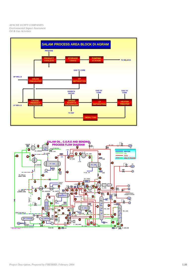
Oil and Gas Processing Facility Process Descriptions
OIL PLANTS
Khalda Concession Oil Treating Facility
The processing system at the Khalda concession is referred to as the Salam oil treating facility
consisting of oil, water, and gas separation. The oil conditioning consists of separators to separate
the oil, gas, and water into three distinct phases. Oil goes to a heater treater to further reduce the
entrained and free water concentration. Next it flows to a desalting vessel that conditions the oil
further to meet the sales quality specification. Processed oil meeting the sales specification are
stored in tanks. Shipping pumps deliver this oil the sales pipeline. This pipeline goes to the Meliha
Gathering facility.
Separated water flows from the aforementioned vessels to an API separator to remove entrained oil
from the continuous water phase.
The oil processed in this facility comes from wells that produce crude oil. This oil has a certain
amount of gas associated with it. This gas is separated during the aforementioned processing
scheme. This gas, referred to as “associated gas” is processed within this oil facility. Twenty (20)
Million Standard Cubic Feet of gas can be processed within this oil facility on a daily basis. This rate
is referred to as 20 MMSCFD. This associated gas has it pressure increased by compressors within
the processing system. Some of the higher pressure gas is dehydrated and put in a sales line. The
remaining gas flows to the Salam Gas Plant. This is physically a separate plant and is described in
the gas plant section below.
The next two diagrams in this write up illustrate this description. The first one is a block diagram,
depicting the major processing schemes as boxes, with arrows showing how flow proceeds through
the plant. The second diagram is called a schematic. It shows all the actual components in the
process, with “a schematic drawing” of each device. Flow arrows show how the flow proceeds
through the plant.
APACHE EGYPT COMPANIES Environmental Impact Assessment Oil & Gas Activities
Project Description, Prepared by FIREBIRD, February 2004 1.10
07-04-03
HP WELLS
LP WELLS
PROPANE
GAS TO CORE
KHARITA WATER
GAS TO CORE
GAS TO CORE
TO W/F
TO MELIEHAPRODUCT COOLERS
STORAGE TANKS
PUMPING STATION
CRUDE PREHEATER
HP SEPARATION
LP SEPARATION
HEATER TREATER
DESALTING
CRUDE/ KHARITA
EXCHANGER
CRUDE/ PRODUCT
EXCHANGER
SALAM PROCESS AREA BLOCK DIAGRAMSALAM PROCESS AREA BLOCK DIAGRAM
07-04-03
FSALAM OIL , C.O.R.E AND SENDING
PROCESS FLOW DIAGRAMSALAM OIL , C.O.R.E AND SENDING
PROCESS FLOW DIAGRAM
D:/MAGED/MYDOC/SALAM PROCESS FACILITIES
MOGHRA WATER
Case (2)
ZERO GOR WELLS
PV - 1113/1114 FH - 1102/1104
“Opt
ion”
TW - 1002
FM
FM
Cas
e (1
)
R-EG-LPCase (3)
C - 1001 A/B/C
FM
1107
PV - 1002 PV - 1003
EX - 1003 EX - 1002
EA - 1001
PW-HT
TW - 1720
RichTEG
TW - 1101
FFM1108
LEAN TEG TEG
SGP
EA -
1701
B
TO MATROUH POWER STATION
FG
F
C - 1701
F
SGP
AG
FM1205R- DIL - HP
FM1206
SGP
HP
HP - GAS
EX - 1303
L-EG2
L-EG1
EX - 1201
PV - 1202
EA - 1701A
L-EG4L-EG3
EX - 1301
EX - 1001FMFM
L-EG5
PV -1101/1102/”C”
FM
1101 1102
KHARITA WATER
EX - 1101/1103 EX - W2 AB
1112
FM
1201
FM1202
PW-HP5
1203
TO MELEIHA
A/B/C
PV - 1201
T - 1901
A/B/C
EX - 1203B
EX - 1302A/B
FM1303A/B
EX-1203AlB
HP - WELLS (HIGH - GOR)
LP - WELLS (LOWER- GOR)
FM P - 1001 A/B
PW
FM
P - ……….
1111
FM 1110 1109
FM
1106
1113/1114
5401
FM
JMS / MEF / MMM
WATEROILGASMULTI PHASE
37B 59
55
43
56
16
15
17
60
61
62
1
57
40
2
14
3
4
5 6
9
7
8
10
8A
8B
31
18
19 21
20 22
22A
22B 22C
23
27
30
2913
2412
34
35D
36A35B
35A
35C
49
48
48A
47
50
51
53
54
45
37A
39
44
19B
25 26
1134
25
28
PW-LP5
41F37A
DR
46
52
33
36
38

APACHE EGYPT COMPANIES Environmental Impact Assessment Oil & Gas Activities
Project Description, Prepared by FIREBIRD, February 2004 1.11
South Umbarka Concession Oil Facility
The processing system at the South Umbarka concession consists of oil, water, and gas separation.
Oil from the wells flows directly to fired heaters, where the oil, water, and gas mixture is heated to
enhance three phase separation. The heated well stream then flows to a three phase separator. In
these separators oil, gas, and, water are separated. Oil flows to a heater treater for further processing
in order to meet sales quality specifications. Tanks store all the oil meeting the quality specification.
Shipping pumps deliver the oil to a pipeline. This pipeline terminates at the storage tanks of the
Umbarka Oil Facility described in the next section.
Water from the separators goes to an API separator to remove entrained oil that is carried over in the
continuous water phase.
All separated gas is flared.
The illustration below shows this facility in a schematic style.
07-04-03
South Umbaraka FACILITIESSouth Umbaraka FACILITIES FLARE STACK
FLAREK.O. POT
3* 10000 BPD
@ 1000 PSI
Khep-Umb P/L 8” ,12 miles
KALAB-KHEB P/L4” .20 MILES
2*8400 BPD @ 97 PSI
(BOOSTER)
PROD.TANK-1
10,000 BBL
PROD.TANK-1
10,000 BBL
PROD.TANK-2
10,000 BBL
PROD.TANK-2
10,000 BBL
PROD.TANK-3
10,000 BBL
PROD.TANK-3
10,000 BBL
TESTTANK
3,000 BBL
TESTTANK
3,000 BBL
WATERTO API
SEPARATOR
SEP.-1 4500 BFPD
SEP.-1 4500 BFPD
2.5 MMBTU/HR
2 MMBTU/HR
2.5 MMBTU/HR
6.0 MMBTU/HR
H.T
H.T
H.T
SEP.-2 5000 BFPD
SEP.-2 5000 BFPD
Hanover 5000 BFPD
WPS 10000 BFPD
SIVALLS
WPS H/T
4286 BPD@ 1058 PSI
Test Heater 1.2 MMBTU/HR
Old Capacity: 11,800 bopd/15,000 bfpd
New Capacity: 20,000 bopd/25,000 bfpd

APACHE EGYPT COMPANIES Environmental Impact Assessment Oil & Gas Activities
Project Description, Prepared by FIREBIRD, February 2004 1.12
Umbarka Concession Oil Facility
The process at the Umbarka oil treating facility consists of oil, water, and gas separation. The oil
conditioning consists of separators and indirect heaters to help with the separation of the oil and
water. The oil then goes to a heater treater to further reduce the water content in the oil. Tanks store
all the oil meeting the quality specification. Shipping pumps deliver the oil to the sales pipeline. This
sales pipeline goes to Meliha gathering facility.
The water from the separators goes to an API separator to remove the entrained oil that is carried
over in the continuous water phase.
The illustration below shows this facility in a schematic style.
07-04-03
TESTTANK
3,000 BBL
TESTTANK
3,000 BBL
TEST TANK25,000 BBL
TEST TANK25,000 BBL
TEST TANK
14000 BBL
TEST TANK
14000 BBL
TANK25000 BBL
TO FLARE OR
S. UMB. GAS PLANT
GAS TO FLARE
TEST (SEP.)
WATER
WATER
WATER
WATER
WATER
4500 BFPD4500 BFPD
5000 BFPDSIVALLS
4500 BBLD4500 BBLD
WPS 10,000 BBLD
WATER
WATER
2.1 MM BTU/HR
2 MM BTU/HR
2.5 MM BTU/HR
2.5 MM BTU/HR
6.0 MM BTU/HR
TO API SEP.
2*17690 BPD @ 21 PSI
6650 BPD 1445 PSI
2*17,690 BPD @ 720 PSI (6 Stg)
UMB.-MEL.P/L 8”61.24 MILE
NEEDED
NEEDED
UMBARKA FACILITIES
SIVALLS
SIVALLS
WPS H/T
17,690 BPD@ 21 PSI
17,690 BPD@ 720 PSI
5000 BFPDSIVALLS
WATER
SIVALLS
Old Capacity: 8,200 bopd/13,200 bfpd
New Capacity: 20,000 bopd/25,000 bfpd

APACHE EGYPT COMPANIES Environmental Impact Assessment Oil & Gas Activities
Project Description, Prepared by FIREBIRD, February 2004 1.13
Qarun Concession Oil Treating Facility
The processing system of Qarun consists of oil, water, and gas separation. The oil conditioning
consists of separators to separate the oil, gas, and water into three distinct phases. Oil goes to a
heater treater to further reduce the entrained and free water concentration. Next it flows to a desalting
vessel that conditions the oil further to meet the sales quality specification. Processed oil meeting the
sales specification are stored in tanks. Shipping pumps at the Qarun facility deliver this oil to a 16”
pipeline owned and operated by Qarun. This pipeline terminates at place called Dahshour, 50
kilometers due east of the plant.
The oil at Dahshour is stored in two 350,000 BBL floating roof tanks. This oil can be pumped into the
Suez Mediterranean Pipeline by pumps owned and operated by Qarun. Alternatively, Petroleum
Pipeline Company can pump from these tanks. Oil flowing this route terminates at a Cairo refinery.
Separated water flows from the aforementioned vessels to an API separator to remove entrained oil
from the continuous water phase.
The oil processed in this facility comes from wells that produce crude oil. This oil has a certain
amount of gas associated with it. This gas is separated during the aforementioned processing
scheme. This gas, referred to as “associated gas” is processed within this oil facility. Twelve (12)
Million Standard Cubic Feet of gas can be processed within this oil facility on a daily basis. This rate
is referred to as 12 MMSCFD. This associated gas has it pressure increased by compressors within
the processing system. The gas is then dehydrated. All the hydrocarbon components heavier than
C5+ (Pentane) are removed from the gas stream. These components are liquid mixed with the
processed oil. The gas flows to a sales gas pipeline operated by British Petroleum Corporation.

APACHE EGYPT COMPANIES Environmental Impact Assessment Oil & Gas Activities
Project Description, Prepared by FIREBIRD, February 2004 1.14
The block diagram depicts this process.
07-04-03
HP WELLS
LP WELLS
PROPANE
GAS TO gas plant
WATER GAS TO CORE
GAS TO CORE
TO W/F
TO DahshourPRODUCT COOLERS
STORAGE TANKS
PUMPING STATION
CRUDE PREHEATER
HP SEPARATION
LP SEPARATION
HEATER TREATER
DESALTING
CRUDE/ EXCHANGER
CRUDE/ PRODUCT
EXCHANGER
Qarun PROCESS AREA BLOCK DIAGRAMQarun PROCESS AREA BLOCK DIAGRAM
GAS PLANTS
The Khalda Concession currently has two gas plants. The process description of each is described
below.
Salam Gas Plant – is located adjacent to the Salam oil processing system. They share some utility
systems. This plant processes gas from the Khalda Concession and dehydrated gas from the South
Umbarka Concession.
The plant has a gas treatment system that includes membranes that reduce the Carbon Dioxide
Concentration of the sales gas to less than 3 mole percent and a dehydration system that reduces
the water concentration to less than 4 pounds per MMSCFD. The design flow rate is 200 MMSCFD.
The gas is compressed, metered, and exported via, the Western Desert Gas Pipeline, also referred
to as the Northern Gas Pipeline.

APACHE EGYPT COMPANIES Environmental Impact Assessment Oil & Gas Activities
Project Description, Prepared by FIREBIRD, February 2004 1.15
Condensate is received at the plant from the wells, and also as produced by the process. This
condensate is stabilized to a Reid Vapor Pressure of 10 psi. It is then stored and pumped to the
crude oil sales line flowing from the Salam Oil Plant, previously described.
SALAM PLANTPROCESS BLOCK DIAGRAM
EXPORT GASMETERING
STORAGETANK
INLET SEPARATOR
INLET SEPARATOR
GLYCOLCONTACTOR
GLYCOLCONTACTOR
TURBOEXPANDER
TURBOEXPANDER
EXPORT GASCOMPRESSOR
EXPORT GASCOMPRESSOR
1ST STAGEMEMBRANE
PRETREATMENT
1ST STAGEMEMBRANE
PRETREATMENT
1ST STAGEMEMBRANE
1ST STAGEMEMBRANE
LP PERMEATECOMPRESSOR
HP PERMEATECOMPRESSOR
2ND STAGEMEMBRANEPRETREATMENT
2ND STAGEMEMBRANE
TO FUEL GASSYSTEM
CONDENSATE
STABILIZATION
2ND STAGESEPARATOR
SLUG CATCHERS.U.GAS METERING
FLARE A.G. COMPRESSOR
RECYCLECOMPRESSOR
SALES GAS
CONDENSATE TOEXPORT PIPELINE
MELEIHA/EL HAMRA
TUT
SALAMSOUTH
SHAMSINLET
MANIFOLD
FROM S. U.GAS PLANT
FROM EXISTING TEG A.G.
FROM EXISTING H.P. GAS
FROM EXISTING FLARE A.G.
FROM WELLS
TRAIN “A”
TRAIN “B”
JMZ/PP/SALAM/REV2
H. P. FLARE
L.P. FLARE
GAS FLOW METER
CONDENSATE FLOW METER
NGL FLUSHDRUM
FQIP, T
FQIP, T
FQIP, T
FQIP, T
FQIP, T
FQIP, T
FQIP, T
FQIP, T
FQIP, T
FQIT
FIFI
FI
FI
FI
FQI = FLOW INDICATOR (Totaliser)P, T = Press and Temp compensated
FI = FLOW INDICATOR
FRP, T
FRP, T
FRP, T
FRP, T
FR = FLOW RECORDER
FI
FI
FQIP, T
FQIT
TO FLARE
Tarek Gas Plant – Is located about 60 km NE of Salam Gas Plant. This plant processes Khalda
Concession Gas and gas from the Ras Kanayes, Res El Hechma, and Matrouh concessions.
The plant has a gas treatment system that includes membranes that reduce the Carbon Dioxide
Concentration of the sales gas to less than 3 mole percent and a dehydration system that reduces
the water concentration to less than 4 pounds per MMSCFD. The design flow rate is 100 MMSCFD.
The gas is compressed, metered, and exported via, the Western Desert Gas Pipeline, also referred
to as the Northern Gas Pipeline.
Condensate is received at the plant from the wells, and also as produced by the process. This
condensate is stabilized to a Reid Vapor Pressure of 10 psi. It is then stored and pumped from the
Plant via 6” pipeline to a 16” crude oil line. This crude oil line runs from Meliha to El Hamra terminal. It
is owned and operated by Agiba Oil Company.

APACHE EGYPT COMPANIES Environmental Impact Assessment Oil & Gas Activities
Project Description, Prepared by FIREBIRD, February 2004 1.16
TAREK PLANTPROCESS BLOCK DIAGRAM
EXPORT GASMETERING
STORAGETANK
INLET SEPARATOR GLYCOLCONTACTOR
TURBOEXPANDER
EXPORT GASCOMPRESSOR
EXPORT GASCOMPRESSOR
1ST STAGEMEMBRANE
PRETREATMENT
1ST STAGEMEMBRANE
PERMEATECOMPRESSOR
2ND STAGEMEMBRANEPRETREATMENT
2ND STAGEMEMBRANE
TO FUEL GASSYSTEM
CONDENSATE
STABILIZATION
2ND STAGESEPARATOR
RECYCLECOMPRESSOR
SALES GAS
CONDENSATE TOEXPORT PIPELINE
MELEIHA/EL HAMRA
TAREK(3 WELLS)
INLETMANIFOLD
FROM WELLS
JMZ/PP/TAREK/REV2
TEST SEPARATOR
TESTMANIFOLD
H. P. FLARE
L.P. FLARE
GAS FLOW METER
CONDENSATE FLOW METER
NGL FLUSHDRUM
FQIP,T
FQIP,T
FQIP,T
FI
FI
FI
FI
FI
FI
FQIP,T
FQIP,T
FRP,T
FRP,T
FRP,T
TO FLARE
FQI = FLOW INDICATOR (Totalizer)P, T = Press. and Temp. compensated
FI = FLOW INDICATOR FR = FLOW RECORDER
South Umbarka Plant – is located about 60 km west of the Salam Gas Plant. The plant has a
capacity of 33 MMSCFD. Gas is dehydrated and exported to the Salam Plant. Condensate is
stabilized and then pumped into the South Umbarka Crude oil facility described previously. The oil
and condensate mixture is then exported to the Umbarka concession, mixed, and evacuated to the
Meliha Gathering Facility.
SOUTH UMBARKA PLANTPROCESS BLOCK DIAGRAM
STORAGETANK
INLET SEPARATORGLYCOL
CONTACTOR
2ND STAGESEPARATOR
CONDENSATE TOEXPORT TO EXISTINGOIL STORAGE TANKSAT KHEPRI FACILITIES
INLETMANIFOLD
FROM WELLS
JMZ/PP/SUMBARKA REV2
H. P. FLARE
L.P. FLARE
TO SALAM PLANT
TO HP FLARE
LOW PRESSURESEPARATOR
TO LP FLARE
P=38 barQ=33 MMscfd
E
KHEPRISETHOS-W
FQIP, T
FQIP, T
FQIP, T
FI
FI
FI
FQIT
FI
FQI = FLOW INDICATOR (Totalizer)P, T = Press. and Temp. compensated
FI = FLOW INDICATOR
FR = FLOW RECORDER
GAS FLOW METER
CONDENSATE FLOW METER
TO FUEL GAS
APACHE EGYPT COMPANIES Environmental Impact Assessment Oil & Gas Activities
Project Description, Prepared by FIREBIRD, February 2004 1.17
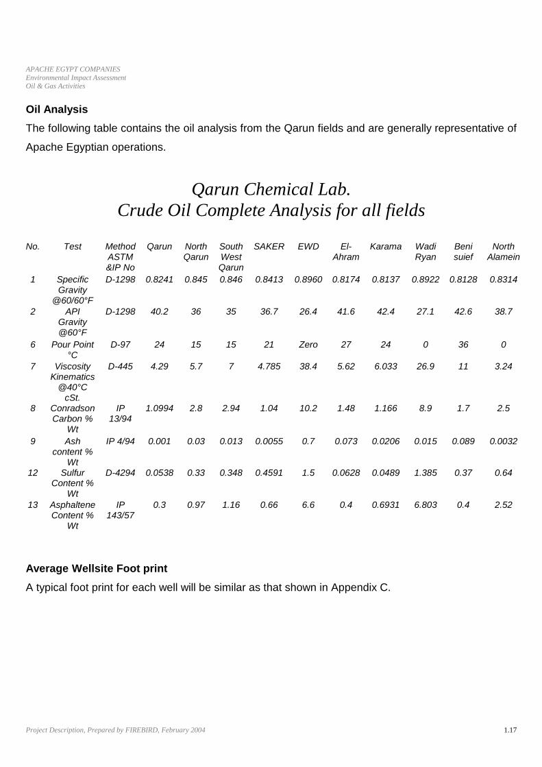
Oil Analysis The following table contains the oil analysis from the Qarun fields and are generally representative of
Apache Egyptian operations.
Qarun Chemical Lab. Crude Oil Complete Analysis for all fields
No. Test Method
ASTM &IP No
Qarun North Qarun
South West Qarun
SAKER EWD El-Ahram
Karama Wadi Ryan
Beni suief
North Alamein
1 Specific Gravity
@60/60°F
D-1298 0.8241 0.845 0.846 0.8413 0.8960 0.8174 0.8137 0.8922 0.8128 0.8314
2 API Gravity @60°F
D-1298 40.2 36 35 36.7 26.4 41.6 42.4 27.1 42.6 38.7
6 Pour Point °C
D-97 24 15 15 21 Zero 27 24 0 36 0
7 Viscosity Kinematics
@40°C cSt.
D-445 4.29 5.7 7 4.785 38.4 5.62 6.033 26.9 11 3.24
8 Conradson Carbon %
Wt
IP 13/94
1.0994 2.8 2.94 1.04 10.2 1.48 1.166 8.9 1.7 2.5
9 Ash content %
Wt
IP 4/94 0.001 0.03 0.013 0.0055 0.7 0.073 0.0206 0.015 0.089 0.0032
12 Sulfur Content %
Wt
D-4294 0.0538 0.33 0.348 0.4591 1.5 0.0628 0.0489 1.385 0.37 0.64
13 Asphaltene Content %
Wt
IP 143/57
0.3 0.97 1.16 0.66 6.6 0.4 0.6931 6.803 0.4 2.52
Average Wellsite Foot print A typical foot print for each well will be similar as that shown in Appendix C.

2. Baseline Environment

APACHE EGYPT COMPANIES Environmental Impact Assessment Oil & Gas Activities
Baseline Environment, Prepared by FIREBIRD, February 2004 2.2
The Environmental Profile includes an inventory of the biotic and abiotic
components of the environment and their interaction. The presented data will
include physical, biological and ecological features of all areas that host
Apache operations in Egypt.
An environmental profile is very useful for identifying main environmental
effects, adverse and beneficial, likely to result from mentioned activities.
Mitigation measures are applied in order to avoid environmental damage, and
depletion of available natural resources that may result from the projects
negative environmental impacts.
Most of the Apache concessions, as per maps in appendix A, belong to the
Egyptian Western Desert and distributed among three separate areas as
shown in maps included in Appendix A:
• Area 1 - including East Bahariya, Khalda, Matruh, Umbarka, South
Umbarka, Ras El Hekma, Ras Kanayes, and NEAG areas (East Bahariya Area);
• Area 2 - including Qarun, Wadi Rayan Development Lease and WD 19
Blocks; and
• Area 3 - including East Beni Suef.
In this section, we will summarize the main features of the different
environments that prevail in the Apache concession areas, skipping only
areas (offshore and onshore) that belong to the Mediterranean Sea. Baseline
Environment of these areas was covered thoroughly in the Full EIA report that
was submitted to OPIC last year for the West Mediterranean deepwater
development project.

APACHE EGYPT COMPANIES Environmental Impact Assessment Oil & Gas Activities
Baseline Environment, Prepared by FIREBIRD, February 2004 2.3
2.1 AREA 1
The last environmental survey for Area 1 was carried out on 18/10/2003 and
soil samples were collected for environmental analysis.
Areas that are part of Area 1 and share the same general environmental
features are the Qarun East Bahariya Concession and all of the Khalda
Concessions.
2.1.1 Geological, Meteorological & Hydrological status Area 1 as a whole lies approximately in the middle and Western section of the
Western desert. This section is essentially a flat plateau with numerous
closed-in depressions. According to Said (1962) the oasis of Farafra and East
Bahariya are situated in the great plateau of Eocene limestone, which extends
from about Lat. 25° N to about Lat. 29° N. This plateau rises, in places, over
500 m above sea level and forms the dominant feature of the major part of the
western desert in Egypt. To the northeast of Bahariya, the plateau rises and
forms Gebel Qatrani. While, to the northwest, this plateau slopes gradually
towards Siwa and the great Qattara Depression where the ground descends
below sea level (lowest site: 142 m). The site is characterized by its flat nature
with the western side of the Area 1 bordered by a belt of sand dunes.
2.1.1.1 Climate
According to Ayyad and Ghabbour (1986) with some modification: according
to the system applied in the UNESCO map of the world distribution of arid
regions (UNESCO, 1979), Area 1 is included in the hyperarid province which
includes all the area between Lat. 22° and 30° N. The rain in this province is
less than 30 mm/year and is occasional and unpredictable.
In the Western desert oasis the range of annual temperature variation ranges
from a mean minimum of 4°C in the coldest months (Dec.-Feb.) to a mean
maximum of 38°C in the hottest months (Jun.-Aug.)

APACHE EGYPT COMPANIES Environmental Impact Assessment Oil & Gas Activities
Baseline Environment, Prepared by FIREBIRD, February 2004 2.4
2.1.1.2 Meteorological Conditions of the Area
The closest weather station to Area 1 is North Qarun and Bahariya. The
following data is compiled from Egyptian Meteorology Authority and
summarized as follows:
2.1.1.2.1 Temperature
Jan. Feb. Mar. Apr. May June. July Aug. Sep. Oct. Nov. Dec.
12.99 12.21 14.75 18.67 24.70 26.66 28.20 28.39 27.38 21.92 18.63 13.24
Table 2.1 Air Temperature
Temperature
10
15
20
25
30
Jan Feb Mar Apr May Jun Jul Aug Sep Oct Nov Dec
(C)
Figure 2.1 Air Temperature Distributaries allover the Year
2.1.1.2.2 Air Pressure
J a n . Feb . Mar . Ap r . M a y June. J u l y A ug. Sep. O c t . Nov. Dec. 1020.9 1019.1 1017.5 1017.1 1014.6 1014.2 1011.8 1012.2 1015.2 1019.3 1020.1 1022.2
Table 2.2 Air Pressure

APACHE EGYPT COMPANIES Environmental Impact Assessment Oil & Gas Activities
Baseline Environment, Prepared by FIREBIRD, February 2004 2.5
Air Pressure
1010
1012
1014
1016
1018
1020
1022
1024
Jan Feb Mar Apr May Jun Jul Aug Sep Oct Nov Dec
(mb)
Figure 2.2 Air Pressure Curve
2.1.1.2.3 Wind Speed
Jan. Feb. Mar. Apr. May June. July Aug. Sep. Oct. Nov. Dec. 2.60 3.99 3.59 4.64 4.82 5.40 4.69 5.31 4.78 4.88 4.99 2.11
Table 2.3 Wind Speed
Wind Speed
22.5
33.5
44.5
55.5
6
Jan Feb Mar Apr May Jun Jul Aug Sep Oct Nov Dec
Figure 2.3 Wind Speed
2.1.1.2.4 Relative Humidity Jan. Feb. Mar. Apr. May June. July Aug. Sep. Oct. Nov. Dec.
56.22 48.35 48.06 40.31 38.23 36.82 40.34 43.19 45.36 47.79 57.66 55.11
Table 2.4 Relative Humidity

APACHE EGYPT COMPANIES Environmental Impact Assessment Oil & Gas Activities
Baseline Environment, Prepared by FIREBIRD, February 2004 2.6
Relative Humidity
30
35
40
45
50
55
60
Jan Feb Mar Apr May Jun Jul Aug Sep Oct Nov Dec
(%)
Figure 2.4 Relative Humidity
2.1.1.2.5 Evaporation
Table 2.5 Evaporation J a n . F eb. Mar. A p r . M a y June. J u l y Aug. Sep . O c t . Nov. Dec.
3 . 7 8 5.03 5.91 12.66 20.37 25.35 23.60 25.67 20.25 14.67 9 .60 3.18
Evaporation
0
5
10
15
20
25
30
Jan Feb Mar Apr May Jun Jul Aug Sep Oct Nov Dec
(cm
)
Figure 2.5 Evaporation Rate 2.1.1.3 Ground Water

APACHE EGYPT COMPANIES Environmental Impact Assessment Oil & Gas Activities
Baseline Environment, Prepared by FIREBIRD, February 2004 2.7
The Western desert is divided into 3 principle sections: the southern section of Nubia sandstone plateau, the middle section of limestone plateau and the Miocene northern plateau. The Karama oasis is located within the middle limestone plateau. Abu Al-Izz (1971) reported that the oasis depressions of this plateau including Bahariya depend on ground water resources from Nubia sandstone aquifers. He added that the Western desert is generally conceived as a barren plain with an apparently internal drainage system. In the Southern Nubia sandstone, water layers are relatively shallow (60--100 m).
2.1.2 Survey of the topography and soil analysis
Area 1 site is characterized with its flat nature with some slight elevations. The
western side of the area is limited by a belt of sand dunes. The surface soil is
covered with gravel sand to sand. Numerous patches of silicified wood is
scattered in the area.
2.1.2.1. Loss on Ignition
Loss on ignition data shows relatively low content of organic matter
(Table 2.6).
Table (2.6) Heat Treatment Results
SAMPLE LOCATION Moisture as (%) Loss on ignition as (%)
Ash (%)
Area 1 0.87 1.65 97.48
Figure 2.6 Heat Treatment Results
Heat treatment results
Moisture%
LOI%
Ash%

APACHE EGYPT COMPANIES Environmental Impact Assessment Oil & Gas Activities
Baseline Environment, Prepared by FIREBIRD, February 2004 2.8
2.1.2.2. Grain Size Analysis
The sample from the area site showed unimodal distribution of grain size
indicating moderate to high sorted sediment.
Sieve No S Sieve Open (mm) Passing% 1 " 25 100 3\4 19 87 1\2 12.5 85 3\8 9.5 82
No 4 4.75 74 10 2 70 20 0.85 68 40 0.475 64 60 0.25 23
100 0.15 19 200 0.074 14
Table (2.7) Percentage of Size Fractions
Visual & manual description Grain size parameters of soil
Location Area 1 A S T M Classification SM Colour Light brown Uniformity coefficient ( C u ) NA
Structure Slightly cemented Effective diameter in ( mm ) NA
Name
Calcareous gravelly fine sand contains some silt
Uniformity curvature ( C z ) NA
Table (2.8) Classification of Soil Sample
Figure (2.7) Histogram Showing the Grain Size Distributions of Soil Sample
Area 1
0
20 40
60
80 100
120
1 " 3\4 1\2 3\8 No 4 10 20 40 60 100 200
Siveve No.
Passing %
Area 1

APACHE EGYPT COMPANIES Environmental Impact Assessment Oil & Gas Activities
Baseline Environment, Prepared by FIREBIRD, February 2004 2.9
2.1.2.3 SOIL CHEMICAL ANALYSIS
Location: Area 1
I. SAMPLE DESCRIPTION : Colour : Light brown
Texture : Slightly cemented
Name : Calcareous gravelly fine sand contains some silt
II. CHEMICAL ANALYSIS :
NO. Chemical compound calculated as
milligram me equivalent (m. equiv. ) Molecular formula
Result
1 Calcium
Cations
Ca ++ 28.1
2 Magnesium Mg ++ 13.6
3 Sodium Na + 5.2
4 Potassium K + 1.7
5 Carbonates
Anions
CO 3 - - 1.50
6 Bicarbonates HCO 3 - 5.65
7 Sulphates SO 4 - - 16.86
8 Chlorides Cl - 24.69
9 Total mineral soluble salts as ppm Ionized salts 2994
10 p H value Log 1
7.4 ( H + )
11 Conductivity at 25 o C on m. hos / cm E C 4.40
III. GENERAL NOTES : 1 :2 ratio soil sample : water extract was used in chemical analysis
Table 2.9 Chemical Soil Analysis

APACHE EGYPT COMPANIES Environmental Impact Assessment Oil & Gas Activities
Baseline Environment, Prepared by FIREBIRD, February 2004 2.10
2.1.3 Flora & Fauna
The fragile and unique ecosystems of the oasis are relatively far from the
concession under investigation. The nearest inhabited oasis to the Apache
concessions is Karama which is typically made of a number of settlements
based on artesian springs or wells. The area of the concessions is generally
poor in plant and animal life. The plant life is essentially ephemeral and
depends on the chance occasion of cloud burst incidents that may happen
once in several years (accidental type of vegetation) (Kass, 1966). A most
noticeable and an important biotopographic unit for animals in this habitat type
are the phytogenic mounds. These mounds which are usually formed around
Nitraria retusa, Calligonum comosum or Tamarix sp. add greatly to the
structural diversity of this habitat, thus creating more niches for animals
including birds (Saleh et al., 1988). In different sites, around and close to the
phytogenic mounds, some tracks of geckos and lizards were observed. There
were also some excreta of medium sized mammal (probably wolf or fox). It is
worthy to mention that the vicinity of Area 1 is considered as accidental
habitats which occasionally have rich areas of ephermal pasture which are
exploited by the wide ranging slender-horned Gazelle Gazalla leptoceros
leptoceros (Saleh, 1993). The nature of the area as accidental habitat,
because of lack of rainfall, is limiting the structural diversity of vegetation and
also the vertebrate fauna. Therefore, the following table shows the vertebrate
fauna that are likely to be supported in this habitat.
Table (2.10): Vertebrate Fauna Latin name of species English name Geckos: Stenodactylus stenodactylus stenodactylus Lizards: Acanthodactylus boskianus Acanthodactylus scutellatus scutellatus Mesalina rubropunctata Snakes: Malpolon moilensis Spalerosophis diadema cliffordi Cerastes cerastes Echis carinatus
Elegant Gecko Bosc's lizard Nidua lizard Red spotted lizard Moila snake Clifford's snake Horned viper Saw-scaled viper

APACHE EGYPT COMPANIES Environmental Impact Assessment Oil & Gas Activities
Baseline Environment, Prepared by FIREBIRD, February 2004 2.11
Rodents: Meriones libycus libycus Pachyuromys duprasi natronensis Carnivores: Canis aureus Vulpes sp.
Jird Egyptian fat-tailed Jird Jackal or wolf Fox
(Compiled from Saleh, 1997) Except for the first gecko, the status of all these reptiles is Lower risk (least
concern), which means that the taxa do not qualify for Conservation
Dependent or Near Threatened.
From the snakes found in the concession, two species are very
dangerous. Antidotes should be available in case of emergency.
2.1.4 Socio-Economic Features Area 1, as mentioned, is located within the Western Desert in a hyper-arid
area. The area is almost desert. High temperature, rare rainfall, extreme
drought and lack of vegetation cover are the dominant characteristic
conditions of this area. There is no population in this area. No Bedouins were
observed, probably because of the lack of vegetation. Generally, the
inhabitants of the Western Desert, Eastern Desert and Sinai Peninsula
represent only 1.2% of the total population in Egypt with a rate of 1 person / 6
kilometers. Oil and gas activities usually attract labor to this area and
consequently would offer jobs to many residents.
Medical Services
The nearest residential spot is 6th of October City, which is located before the
East Bahariya site by about 140 kilometers. The Apache Base is well
equipped and accommodated for human needs, and located a few kilometers
from the site. Accordingly, good dependable medical services or first aid
facilities are available in the area. Basic medical services are present ready to
respond to any unexpected injuries to the workers.

APACHE EGYPT COMPANIES Environmental Impact Assessment Oil & Gas Activities
Baseline Environment, Prepared by FIREBIRD, February 2004 2.12
Archeology
The concession has no archeological features and the surrounding area has
no history of archeological services. However, if any evidence appears
activities will be stopped and immediate notification will be made to the
appropriate authorities (e.g. Archeology Authorities).
Inter-Agency & Public Involvement
Normal involvement such as obtaining acceptance of EGPC, EEAA, Local
Governorate, and Ministry of Defense will be conducted as appropriate.
2.2 AREA 2 This area is representative of the conditions associated with the Wadi El-
Rayan, Qarun and WD 19 concessions and lies in the Fayoum Governorate
which is a natural Depression. The area of the Depression is about 12,000
km2 surrounded by desert uplands. The climate is typically arid (low rainfall
and bright sunshine throughout the year). However, the Depression is a very
productive region agriculturally because of the use of Nile water. The
Depression also contains a considerable area of surface water (Qarun Lake-
saline- and Wadi El-Rayan Lakes-freshwater). The lakes cover an area of
about 400 km2.
2.2.1 Geology, Geomorphology and soil Analysis:
Fayoum Depression is 2-10 million years old and was formed by the action of
the arid climate and strong winds on the predominantly fluvio-marine
sediments that comprise the geology of the area. Soils of Fayoum Depression
consist of heavy to light clays derived from Nile flood alluvium. Sandy patches
occur towards the edges of the depression. On the upper slopes, the soils are
well-drained, slightly saline clays while the lower basin soils are poorly drained
and hence highly saline. The soil of the surrounding desert differs to those in
the Depression and range from non-arable sands and gravels, commonly with
high gypsum content, to deep loam sands.

APACHE EGYPT COMPANIES Environmental Impact Assessment Oil & Gas Activities
Baseline Environment, Prepared by FIREBIRD, February 2004 2.13
2.2.1.1 Geological History
Geology and geological history, like climate, are basic building blocks of the
environment of the area. In fact, the character of the rock types has directed
the genesis of the present day landscape. Specific details of Fayoum's and
Beni Suef's geological history are discussed below. With the coming and
going of ancient seas and associated shifting coastlines, the marine
sedimentary landscape has been built up over a period stretching from the
late Cretaceous to the late Pliocene (70 to 2 million years ago). Through
alternations of periods of uplift (and erosion) and with depositions, the
landscape of the area began to evolve.
Land exposure from late Eocene to late Oligocene (40 to 30 million years ago)
allowed the ancient “Libyan River” to begin eroding the thick Eocene
sediments, and laid down some of Egypt’s most valuable fossil deposits of
early mammal, primate, reptile and fish species. The late Miocene, through
Pliocene, (10 to 1.8 million years ago) saw the coastline come and go, as well
as the formation of the ancient Nile valley, and possibly the initiation of the
Fayoum depression.
From Pleistocene to Holocene (1.8 million years to present) the Fayoum
depression and Beni Suef were being formed. The beginning of the present
arid climate (8000 B. C. onwards) and subsequent wind erosion carved out
the then desert depression. Later, during the Pleistocene, the basin subsided
relative to the Nile valley. Subsequent Nile floods allowed deposition of the
present alluvial fan of sediments, and initiated the ancient Lake Qarun. By late
Pleistocene the present day basin was formed and inhabited. The Neolithic
(late stone age) peoples lived around the lake, that showed fluctuating levels
between +5 and +18 m (asl) due to the annual inflow of Nile floodwaters.
Geologically speaking, the formation of the Fayoum depression was made
possible since thick bands of sandy and clay material were breaking up the
continuous hard layer of Middle Eocene limestone. As a consequence of
harder rock strata overlying the softer strata, the boundaries of the depression
are often dramatically marked by escarpments and gebels. To the north and
northwest the Gebel El Qatrani escarpment rises, with its highest point at

APACHE EGYPT COMPANIES Environmental Impact Assessment Oil & Gas Activities
Baseline Environment, Prepared by FIREBIRD, February 2004 2.14
Gebel El-Qatrani 340 m (asl); this is the southern limit of an undulating desert
plateau, stretching with little change in character to the Mediterranean Sea. To
the south is an irregular cliff line, forming the boundary of Wadi El-Rayan and
Wadi Muwellih; the vertical escarpment rises up to 184 m (asl) at Minqar El-
Rayan. Beyond this cliff-line lies an almost unbroken limestone plateau, rising
gradually to the south. To the southwest of the Fayoum, the floor of the
depression merges with the desert plateau beyond.
The Wadi El-Rayan sub-depression is separated from the Fayoum to the
north by a limestone ridge +34 to +60 m (asl). Its area is some 15 km wide, is
largely enclosed within the +20 m contour, and has an average elevation of -
43 m (asl). Its maximum depth falls to - 64 m (asl). Since the opening of the
drainage water tunnel from the Fayoum depression in 1973, the lower areas
of the Wadi El-Rayan depression have been progressively covered by two
lakes. The first lake (Rayan I Lake) reached its maximum level -5 m (asl) in
1978, and covers the Wadi El Masakheet depression. From there the water
flows through a (presently) shallow swampy area (-10 m asl) known as Rayan
II Lake, from which it overflows and runs into the second and lowest
depression, called Rayan III Lake. This lake is still in the process of filling.
According to Wilson and Saleh (1991), the lake will be allowed to reach an
elevation of -13 m (asl) before drainage water inflow will be reduced to
balance with evaporation levels. The present elevation is estimated at -20 to -
25 m (asl). Southwest and southeast of the lower Rayan lake are two smaller,
shallower, depressions: Wadi Muwellih (20 to 50 m asl), and Oyun El-Rayan
(0 to 25 m asl). The latter one lies below Minqar El Raiyn, and supports three
natural springs; it is separated from El-Rayan depression by dune fields and
rock terraces (up to 50 m asl). The dune fields separating all three basins are
extensive, and consist mostly of Seif (longitudinal) dunes, varying from
several hundred meters to 30 km in length and up to 30 m in height.
2.2.2 Fossiliferous Sites
The sediments of Fayoum depression range in age from the late Cretaceous
(70 million years ago) to Pliocene (2 mya). Lake Qarun, Qasr El-Sagha and
Gebel Qatrani formation deposited during the late Eocene (40 mya) to late

APACHE EGYPT COMPANIES Environmental Impact Assessment Oil & Gas Activities
Baseline Environment, Prepared by FIREBIRD, February 2004 2.15
Oligocene (30 mya) contain a wide range of fossil deposits of early mammals,
primates, reptiles and fishes. These represent some of the richest fossil
deposits in Egypt and their discovery was of international importance.
2.2.3 Surface water quality
Lake Qarun is located about 100 km to the south-West of Cairo. It is a closed
inland basin of 40 km in length and a mean width of 5.7 km. The lake area is
about 255 km2. Maximum water depth is 12 m while the mean depth is 4.2 m.
The level of the lake was rising and flooding the neighboring agricultural lands
due to the feed of fresh water from two main drains, El-Bats and El-wadi.
Since the mid seventies, 80% of the water of El-Wadi Drain was directed to
Wadi El-Rayan Depression. Cutting off the input of the freshwater of El-Wadi
Drain aggravated the old problem of increasing salinity in the lake (since
1901). Therefore, salinity of the Lake Qarun is now reaching 44 ppt in some
regions.
2.2.4 Ground water
The known ground aquifers in Fayoum are contained in Pleistocene and
Eocene limestones and are largely saline.
The Fayoum basin is embedded in Eocene limestone and marls; the only
breach in the surrounding limestone allowing an inflow of ground water is that
through the Hawara gap. A semi-confined Pleistocene groundwater aquifer
connects to the Nile valley through the gap. An estimated amount of 70 l/sec
of groundwater flows into Fayoum which can be considered a negligible
source of basin water recharge if compared to the average irrigation water
supplies of 72 m3/sec. The Oyun El-Rayan springs of the Wadi El-Rayan
basin are reputed to originate from the Nubian sandstone aquifer, but since
they yield brackish water (soluble salts, 2,620 - 4,700 ppm), at low flow rates
(1.6, 4.8 and 14.4 l/min), they do not represent a substantial resource, but are
considered as a life support source to the wildlife existing in the region. The
Oyun El-Rayan was declared a natural park in 1982.

APACHE EGYPT COMPANIES Environmental Impact Assessment Oil & Gas Activities
Baseline Environment, Prepared by FIREBIRD, February 2004 2.16
The Bahariya Oasis, which is found to the west of [Area 2]the concession,
contains several wells tapping the Nubian sandstone.
2.2.5 Soil Analysis
I. SAMPLE DESCRIPTION : Colour : Very light brown Texture : Fragments Name : Calcareous sandy gravel ( limestone fragments ) contains
some silt II. CHEMICAL ANALYSIS :
SNO Chemical compound calculated as milligramme equivalent ( m. equ. )
Molecular formula Result
1 Calcium
Cations
Ca ++ 32.6 2 Magnesium Mg ++ 17.5 3 Sodium Na + 10.9 4 Potassium K + 3.6 5 Carbonates
Anions
CO 3 - - 1.13 6 Bicarbonates HCO 3 - 5.26 7 Sulphates SO 4 - - 29.98 8 Chlorides Cl - 28.33
9 Total mineral soluble salts as ppm Ionised salts 4060
10 p H value Log 1
7.5 ( H + )
11 Conductivity at 25 o C on m. hos / cm E C 5.97 II. GENERAL NOTES : 1 : 2 ratio soil sample : water extract was used in chemical analysis
Table 2.1 Chemical Soil Analysis
2.2.5.1 Heat Treatment Results of Soil Sample
SAMPLE LOCATION
Moisture as % Loss on ignition as %
Ash %
Area 2 1.04 1.87 97.09
Table 4.2 Heat Treatment Results of Soil Sample

APACHE EGYPT COMPANIES Environmental Impact Assessment Oil & Gas Activities
Baseline Environment, Prepared by FIREBIRD, February 2004 2.17
Moisture content , LOI and Ash %
0
20
40
60
80
100
1 2 3 4 5 6Moisture - LOI - ASH %
Figure 2.8 Block Diagram showing Relative distribution of Moisture LOI & Ash Contents of Soil Sample
2.2.5.2 Grain Size Analysis
Sieve No Sieve Open (mm) Passing% 1 " 25 77 3\4 19 64 1\2 12.5 64 3\8 9.5 60 4 4.75 39 10 2 33 20 0.85 30 40 0.475 28 60 0.25 22
100 0.15 16 200 0.074 13
Table 4.3: Percentage of Size Fractions

APACHE EGYPT COMPANIES Environmental Impact Assessment Oil & Gas Activities
Baseline Environment, Prepared by FIREBIRD, February 2004 2.18
Visual & manual description Grain size parameters of soil
Location Area 2 A S T M Classification GM
Colour Very Light brown Uniformity coefficient ( C u ) NA
Structure Fragments Effective diameter in ( mm ) NA
Name Calcareous sandy gravel (limestone fragments) contains some silt
Uniformity curvature ( C z ) NA
Table 4.4 Classification of Soil Sample
Figure 2.9 Histogram Showing the Grain Size Distributions of Sample
2.2.3 Meteorological Data
The area under consideration is located in a hot and dry environment with
scanty winter rain and bright sunshine throughout the year. Its climate is a
typical Saharan hyper-arid system with cold winter and hot summer. The
climate of the region has a big influence on the fauna and flora existing in the
region.
*Refer to Section 2.1 as the parameters are the same.
Wady El-Rayan
020406080
100
1 " 3\4 1\2 3\8 No 4 10 20 40 60 100 200Siveve No.
Pass
ing
%
Wady El-Rayan

APACHE EGYPT COMPANIES Environmental Impact Assessment Oil & Gas Activities
Baseline Environment, Prepared by FIREBIRD, February 2004 2.19
2.2.4 Biological Environment
The biological characteristics of Area 2 may be considered highly variable as
it belongs to three distinct ecosystems, namely the desert ecosystem, the
agricultural ecosystem and the freshwater ecosystem.
2.2.4.1 FLORA
Flora, with links to soil and land supports animal and human life, should be
discussed.
Flora within Area 2 simply can be divided into:
a) Desert flora
b) Flora of the cultivated lands
Desert Flora
Beyond the reach of the system of irrigation canals, the borders of the fertile
alluvial soils and the boundaries of man's farming activities, is where the
Western Desert begins.
The upland desert areas to the north and north east of Fayoum, are
predominantly rocky areas and eroded pavement that appear to carry no
vegetation. Close observation, however, reveals that some vegetation does
exist along the courses of the shallow wadis (flood channels). No detailed
seasonal variation of the vegetation cover are available for these areas, but
species identification and description are found for the desert areas of
Fayoum, where the greatest part of Area 2 occurs, in the Flora of Egypt, from
which the following table was adopted.

APACHE EGYPT COMPANIES Environmental Impact Assessment Oil & Gas Activities
Baseline Environment, Prepared by FIREBIRD, February 2004 2.20
Table (4.5) Listed Plant Species of the Desert Areas of Fayoum
Family/Species Family/Species Family Cruciferae Family Urticacea Forsskalea tenacissima Eremobium aegyptiacum Farsetia aegyptia Zilla spinosa Family Polygonacea Family Leguminosae Calligonum comosum Alhagi marorum Trigonella laciniata Family Aizoaceae Family Zygophyllaceae Mesembryanthenum forsskalei Zygophyllum simplex Aizoon canariense Zygophyllum album Aizoon hispanicum Family Caiyophyllaccae Family Nitrariaceae Spergularia diandra Nitraria retusa Spergula fallax Robbairea delileana Family Cehnopodiacea Family Tamaricaceae Bassia muricata Tamarix aphylla (articulate) Salicornia herbacea T. passerinoides Salsola baryosma T. passerinoides Comulaca monacantha Family Solanaceae Family Gramineae Hyoscyamus muticus Cutandia memphitica Aeluropus lagopoides Family ComDositae Schismus barbatus Echinops spinosissimus Sporobolus spicatus Francoeuria crispa Stipagrostsis ciliate Cotula cinerea Stipagrostis lanata Launaea capitala Cynodon dactylon Panicum turgidum
Source: Tackholm(1974)/Tackholm and Drar 1973
Firm data on the desert flora of Wadi El-Rayan were gathered and published
by Saleh et.al. in 1988 ("Development and Conservation of Wadi El-Rayan"
study of the Foreign Relations Coordination Unit (FRCU) of the Egyptian
Supreme Council of Universities). These survey data concerned the perennial
plant species of the Oyun El-Rayan area; they are listed in Table 3. The
vegetation was restricted around the springs, interdune areas and bases of
large dunes, and comprised four main associations:
• the Alhagi maurorum community in the low lying interdune areas;

APACHE EGYPT COMPANIES Environmental Impact Assessment Oil & Gas Activities
Baseline Environment, Prepared by FIREBIRD, February 2004 2.21
• the Desmostachya bipinnata community in the flat or gently undulating
interdune areas,
• the Tamarix - Nitraria - Calligonum community, widely scattered on
sandy hillocks over a large area of interdunes; and
• the salt marsh community in, or immediately surrounding pools of the
springs.
Table (4.6) Plants of the Area 2 Study Area.
Species Dunes Inter-dunes Springs Trees/Shrubs Tamarix nilotica + + Nitraria retusa ++ Phoenix dactylifera ++ Sub-Shrubs Zygophyllum album + ++ Callogonum comosum + Alhagi maurorum ++ Sedges/Grasses Juncus rigidus ++ Cyperus laevigatus ++ Desmostachya bipinnata ++ Sporobolus spicatus ++ + Imperata cylindrical ++ + Phragmites australis Typha domingnesis ++
+ + = preferred area + = other areas Source: Saleh et.al. (1988).
Flora of the Cultivated Lands:
Systematic botanical survey data are also missing for the flora of the
cultivated lands, but the assumption may be made that this flora is largely
introduced as a result of man's activities, and equivalent to that of the
adjacent areas of the Nile valley. An exception is some patches of saline
marsh adjacent to Lake Qarun, where the vegetation can still be considered
natural. A review of the Flora's of Egypt (Tackholm, 1974; Tackholm and Drar,
1973. and Boulos and Hadidi, 1967), lead to compilation of a list of plant
species that are reported to occur in the Fayoum, with a classification in plants

APACHE EGYPT COMPANIES Environmental Impact Assessment Oil & Gas Activities
Baseline Environment, Prepared by FIREBIRD, February 2004 2.22
of cultivated lands, plants of waste lands and roadsides, plants along the
verges of canals and drains, and plants of marshy lands.
Table (4.7) Flora of the Cultivated Land
Family/species L W C M Family/species L W C M Family Amaranthaceae Family Cyperaceae Alternanthera sessilis + + Cyperus alopecuroides + + + Amaranthus graccizans + + C. articulatus + + A. hybridus + + C. difformis + + A. lividus + + C. lacvigatus + + C. rotundus + + Family Asclepiadaceae Scirptis tuberosus + + + Oxystelma alpine + Family Euphorbia Family Boraginaceae Euphorbia arguta + Heliotropium europaeum + + E. forsskalii + + H. supinurn + E. geniculata + + E. granulata + Family Caryophyllacea E. helioscopia + Silene conoidea + E. peplis + S. nocturna + S. rubella + + Family Gramineae Spergularia marina + Agrostis viridis + + Stellaria pallida + Avena sp + Vaccaria pyramidata + Brachiaria eruciformis + Bromus wildenowii + + Family Chenopodiaceae
Cynodon dactylon + + +
Beta vulgaris + + Dactyloctenium aegyptium
+ + +
Chenopodium album + + Desmostachya bipinnata + + C. ambrosioides + Digitaria sanguinalis + + Dinebra retroflexa + Family Compositae Echinochloa colonum + + Ageraturm conyzoides + E. crus-galli + + Ambrosia maritime + + Eleusine indica + Anthemis pseudocotula + + Imperata cylindrica + + + Family Compositae (cont)
Family Gramineae (cont.)
Aster squamatus + + + Lolium sp. + + Calendula arvensis + + Lolium temulentum + Chamomilla recutila + + Panicum repens + + Cichorium endivia + + Papspalidium geminatum + + Conyza aegyptiaca + + Paspalum paspaloides + + + Erigeron bonariensis + + Phalaris minor + + Eclipta prostrata + + + Poa annua + + +

APACHE EGYPT COMPANIES Environmental Impact Assessment Oil & Gas Activities
Baseline Environment, Prepared by FIREBIRD, February 2004 2.23
Lactuca serriola + Setaria glauca + + + Senecio aegyptius + S. verticillata + + S. flavus + + + S. viridis + Silybuin mariarum + + Phragmites australis + + + Sonchus sp. + + + Sorghum virgatum + + Xanthium sp. + + + Family Juncacaceae Family Convolvulaceae Juncus rigidus + + Convolvulus arvensis + + J. acutus + Cuscuta arabica + Family Labiatae Family Cruciferae Mentha longifolia + + Brassica nigra + Capsella bursa-pastoris + + Family Leguminosae Coronopus niloticus + Alhagi maurorum + + + Lepidium sativum + + Lathyrus hirsutus + Sisymbrium irio + + + Lotus arabicus + + Medicago polymorpha + + + Melilotus indicia + + + Family Poligonaceae Trifolium resupinatum + + Emex spinosus + + + Trigonella hamosa + + Polygonum salicifolium + Vicia monantha + P. senegalense + Rumex dentatus + + + Family Malvaceae Hibiscus trionum + + Family Portulacaceae Malva parviflora + + + Portulaca oleracea + + Family Onagraceae Family Primulaceae Jussiaea repens + + + Anagallis arvensi + Family Orobanchaceae Family Solanaceae Orobanche crenata + Datura sp. + + O. ramosa L + + Solanum nigrum + + + O. muteli v. spissa + Family Oxalidaceae Family Tiliaceae Oxalis corniculata + + Corchorus olitorius + + Family Plantaginaceae Family Umbelliferae Plantago sp. + + + Ammi majus + + + A. visnaga + + Family Utricaceae Utrica utens + +
L = cultivated lands; W = waste lands and road sides; C = verges of canals and drains; M = marshy lands.
APACHE EGYPT COMPANIES Environmental Impact Assessment Oil & Gas Activities
Baseline Environment, Prepared by FIREBIRD, February 2004 2.24
In general cultivated crops in Area 2 are oriented to the needs of the
surrounding population and the Greater Cairo population. Vegetables
(legumes), cotton, corn, sun-flower, palm dates, lime and lemon, etc. are
major crops found in the cultivated part of the Area 2. In a few locations, near
the water resources, rice and other crops that need large amounts of water
are cultivated.
2.2.4.2 FAUNA
Zoogeographics
Of the seven main bio-geographic regions in the world, Egypt falls within the
Palaearctic region, which ranges from the Atlantic coast of Europe to the
Pacific coast of the Soviet Union, with its southern border being formed by the
Sahara desert. The Fayoum - West Beni Suef fauna is also influenced by two
other biographic regions, with representatives of the Oriental realm (e. g. pied
kingfisher) and of the Ethiopian realm (e. g. gazelles and the wolf snake). In
the past, during the warmer inter-glacial epochs, borders of the Ethiopian
realm shifted to the north and true African species such as the wolf snake
(Lycophidium capensis) could settle. To date, this species in Egypt is confined
solely to the Fayoum area.
Mammals
Of the 170 land mammals recorded in Egypt, 27 are known in the Fayoum -
West Beni Suef Area. The Flower’s Shrew (endemic to Egypt) has not
recently been recorded and is believed to have become locally extinct. The
Dorcas Gazelle and the Slender Horned Gazelle are considered vulnerable
species (IUCN, 1988). The occurrence of the latter species (Gazella
leptoceros), discovered in 1984 at Oyun El Rayan, is of global conservation
importance as it may well represent the only surviving population of this
subspecies in the world (Saleh, 1987). This genuine desert species is thought
to be restricted to the sand dune area southwest of the lower El Rayan lake;
realistic estimates of population and distribution range are absent. The main
factor for the ongoing decline in the populations of predators is considered to

APACHE EGYPT COMPANIES Environmental Impact Assessment Oil & Gas Activities
Baseline Environment, Prepared by FIREBIRD, February 2004 2.25
be the large scale application of rodenticides. Other negative factors include
the destruction, or deterioration, of habitats (marsh, treed areas), use of agro-
chemicals, and hunting of the more common mammalian species, the rodents
are well represented with 12 species recorded, including the extremely wide-
spread pest species house mouse and field rat. Of the predators, the jackal is
recorded throughout the Fayoum. Being often referred to as “wolf”, it is
severely hunted by farmers for its said raids on poultry, goats and sheep,
although the species undoubtedly preys mainly on rodents and some fish from
shallow depressions.
Mammal (and other animal) activities are concentrated in gardens, farmlands
and vegetation along the Fayoum lakes. A relatively small number of animals
frequent settlements of the vegetated desert. Only a few species are well
adapted to the extreme conditions of the real desert. An example is the fennec
fox that escapes the intense heat by its nocturnal behavior, obtains most of its
water from its natural food, and whose feet show hair-growth that allows fast
movement in loose sand. The same adaptations are found in the desert
rodents, silky gird and lesser gerbil. The mongoose is probably the only wild
mammal that is active during day time.
Chiroptera (bats) are well represented in Egypt but information on their
occurrence in the area is scanty. Recorded species include the Egyptian fruit-
bat (Rousettus aegyptica), larger rat-tailed bat (Rhinopoma microphyllum),
lesser rat-tailed bat (R. hardwicki), the ban bat (Nycteris thebaica), and the
very rare Eptesicus innesi. Representatives of the Vespertilionidae, or Typical
Bats, include Kuhl’s pipistrelle (Pipistrellus kuhli), Eptesicus innesi, and the
gray long-eared bat (Plecotus austriacus).

APACHE EGYPT COMPANIES Environmental Impact Assessment Oil & Gas Activities
Baseline Environment, Prepared by FIREBIRD, February 2004 2.26
Table (4.8) Mammals usually found in the Area 2.
Scientific name English name status
Behaviour
Hemiechinus auritus aegypticus
Long eared hedgehog
C D/N
Crocidura flavescens deltae Giant musk shrew C D/N Crocidura floweri Flower's shrew VR D/N Lepus capensis rothschildi Hare VR N Gerbillus pyramidum pyramidum
Greater gerbil C N
Gerbillus andersoni andersoni Anderson's gerbil R N Gerbillus gerbillus gerbillus Lesser gerbil C N Dipodillus amoenus arnoenus Charming dipodil C D/N Meriones crassus perpallidus Silky jird C D/N Meriones libycus libycus Libyan jird C D/N Arvicanthis niloticus niloticus Field rat/Kusu C D/N Rattus rattus House rat C N Rattus norvegicus Brown rat C N Mus musculus praetextus House mouse C N Nesokia indica suilla Bandicoot rat C N Jaculus jaculius jaculus Lesser jerboa R N Canis aureus lupaster Jackal R N Vulpes vulpes aegyptiaca Nile fox R N/D Vulpes ruepeili ruepelli Rucpell's sand fox R N/D Fennecus zerda Fennec fox R N Mustela nivalis subpalmata Weasal C N Herpestes ichneumon ichneumon
Egyptian mongoose C D
Hyaena hyaena dubbah Stripped hyena VR N Felis chaus nilotica Jungle cat C D/N Felis sylvestris libya Wild cat C N Gazella leptoceros leptoceros Slender-horned
gazelle VR D/N
Gazella dorcas dorcas Dorcas gazelle VR D/N C = Common R = Rare VR = Very rare D = Day N = Night
Birds
The wetlands provide important habitat for passing and wintering migratory
waterbirds; their most important feeding areas are the Wadi El- Rayan lakes,
the shallow waters in the western and eastern ends of Lake Qarun, and along
the entire northern shore of Lake Qarun. The southern shore of Lake Qarun is
little used by the majority of the wintering species, due to human disturbance.

APACHE EGYPT COMPANIES Environmental Impact Assessment Oil & Gas Activities
Baseline Environment, Prepared by FIREBIRD, February 2004 2.27
Exceptions are the fish and salt ponds of Abuksah bay, which are frequented
by black-necked grebe, waders and gulls.
Common resident breeding species in cultivated areas are the spur-winged
plover, crested lark, cattle egret and hoopoe. Other characteristic residents
are little owl, black-shouldered kite, and Senegal coucal. A number of bird
species have only recently invaded the area. They include some Afro-tropical
species such as common bulbul and the avadavat, and also the blackbird
which is now a common breeding resident in gardens. Characteristic species
of the arid desert are hoopoe lark, cream-coloured courser, and the desert
and mourning wheaters.
Reptiles and Amphibians
Egypt has thirty-three species of snakes, the majority of which also occur in
the area. Common snakes include the diced water-snake ( Natrix tessellate),
green flying snake (Coluber rodorhachis), flowered snake (Coluber florulentis),
and egg-eating snake (Dasypeltis scaber). Other common reptiles and
amphibians of the area include the common tortoise (Testudo graecae),
skinks (Chalcides ocellatus, Mabuya quinquetaemata and Scincus scincus),
gecko (Hemidactylus turcicus), cameleon (Chamaeleo chamaeleon), and
toads (Bufo regularis, B. viridis and B. vittalus).
2.3 AREA 3
Area 3, which includes the Beni Suef Concession is located on the Eastern
and Western sides of the Nile River; most of its terrain is a limestone plateau.
However, the area of the blocks is covered with a layer of silt and clay. The
eastern bank of the river is about 1.5 m above the present water level, while
the western bank is about 4 m above it.
4.2 GEOLOGICAL FORMATION
It is obvious that the area under consideration has two geological
characteristics. The Eastern Desert of Egypt is part of the cultivated land and

APACHE EGYPT COMPANIES Environmental Impact Assessment Oil & Gas Activities
Baseline Environment, Prepared by FIREBIRD, February 2004 2.28
has been developed for urban uses. Generally, the Eastern Desert of Egypt
consists essentially of a backbone of high and rugged igneous mountains
running parallel to the Red Sea Coast. The mountains do not form a
continuous range, but rather a series of mountain groups with some detached
masses and peaks flanked to the north and west by intensively dissected
sedimentary limestone plateaus. The study area is one of these formations.
The formation of these limestone plateaus mainly Upper Eocene (Bartonian)
and Middle Eocene (Lutetiam). The former includes a series of sands, clays
and marly limestone, which are separated; more easily eroded and contain
larger amounts of gypsiferous and ochreous materials. The Middle Eocene
formation includes various types of limestone, which are more solid and
contain hard dolomite bands. The most pronounced geo-morphological
feature of the whole Eastern Desert of Egypt is its dissection by independent
valleys and ravines. Between the highlands and the banks of the River Nile a
gentle slope can be observed. It is divided into salt marshes with sandy
hillocks and flats of calcareous silt, and an inland desert plain covered with
coarse boulders, which become less coarse further away from the hills. The
River Nile north of the Aswan High Dam runs for about 900 km through a
valley that consists of a level-floored groove on a limestone plateau,
averaging 18 km width. Upstream Cairo and for almost 300 km, including the
Beni Suef area, the Nile River shows a strong tendency to hug the eastern
edge of the valley floor in a way that rendered the greater part of the cultivated
land found on the western bank of the river. The River Nile Valley itself went
through numerous changes after the construction of the High Dam, but as a
general feature it consists of the River Nile Channel surrounded by a flood
plain of alluvium material that gradually increases in width from Aswan until it
reaches its maximum at Beni- Suef (+ 12 km). The flood plain is elaborately
cultivated through a well-established irrigation system and a slowly developing
drainage system.

APACHE EGYPT COMPANIES Environmental Impact Assessment Oil & Gas Activities
Baseline Environment, Prepared by FIREBIRD, February 2004 2.29
4.3 Climates and Meteorology
The bioclimatic provinces in Egypt are defined by Ayyad and Gabbour (1986)
with some modification according to the system applied in the UNESCO map
of the world distribution of arid regions (UNESCO, 1979). This system is
based on the aridity index P/ETP (where ETP is potential evapotranspiration)
and is calculated according to Penman's formula. Two classes are
recognized: hyperarid (P/ETP< 0.03), and arid (P/ETP= 0.03-0.20). These
classes are, in turn, subdivided according to the mean temperature of the
coldest month and that of the year. Consideration is also given to the time of
the rainy period relative to the temperature regime. Accordingly, the area of
concern is included in the hyperarid province, which includes all the area
between Lat. 22° and 30° N. The rain in this province is less than 30 mm/year
and is occasional and unpredictable. In the Western Desert, the range of
annual temperature variation ranges from a mean minimum of 4° C in the
coldest months (Dec.-Feb.) to a mean maximum of 38° C in the hottest
months (Jun.-Aug.). The closest meteorological station to the site is north
Qarun and Al-Bahariya. The following data is compiled from the Egyptian
Meteorology Authority and other relevant literatures.
4.3.1 Wind
Three permanent high-pressure belts control the wind circulation over Egypt:
the Azores, the Indian Subtropical, and the South Atlantic Subtropical.
Besides these, a permanent low-pressure belt, the doldrums, crosses the
African continent in the vicinity of the equator. Seasonal high and low-
pressure systems also alternate over the continental mass, the Red Sea, the
Mediterranean and the Arabian Peninsula. During winter, a semi-permanent
low-pressure area known as the Cyprus Low is usually located over the
eastern Mediterranean. These months are the windiest, with dominant winds
from northwest and west-northwest, less frequently from north and northeast.
From November to March-April, cyclonic storms, associated with moving
depressions, appear regularly. Low-pressure centers generally move along
the northern side of the eastern Mediterranean. Such storms are responsible

APACHE EGYPT COMPANIES Environmental Impact Assessment Oil & Gas Activities
Baseline Environment, Prepared by FIREBIRD, February 2004 2.30
for the generation of the highest waves on the Egyptian northern shores.
Weaker storms between Crete and the Nile Delta usually last for two days;
they are less frequent, shorter duration and have shorter fetches.
Thunderstorms occasionally affect the Egyptian coast, accompanied by
sustained winds of 43 to 60 knots for short periods and instantaneous wind
gusts in the range of 70 to 90 knots. These thunderstorms occur particularly
between October and May, less frequently in the summer and early autumn.
During the spring months (April to May) a gradual weakening of the Cyprus
Low coincides with development of a high-pressure ridge over the
Mediterranean and a low-pressure zone over the Arabian Peninsula and the
north-central Sahara. These weaker pressure features result in a decrease of
the average wind speeds over the Mediterranean. When the depressions are
counteracted by strong blasts of polar air, the southwest and south hot and
dry winds (Khamasin, Ghibli) become violent, raise ground temperatures,
lower the relative humidity, and transport sand and dust. In the summer June
to September the high-pressure ridge that runs east-west across the central
and eastern Mediterranean and the low-pressure area over the north-central
Sahara reach their maximum development. Consequently average wind
speeds during summer are greater in July and the dominant winds are from
the west-northwest. From mid-September, the Arabian-Persian depression
disappears progressively, and high-pressure belts from southeast Europe and
North Africa extend over the central part of the eastern Mediterranean,
producing very calm weather in October. Wind prevails from the north,
northeast or northwest, at mild speeds averaging 2.1 m/s only the hot south
westerly Khamaseen gales (March to May) and the cold northerly gales of
February - March provide marked variation. Table (4.1) and figure (4.1)
reflects the values of wind speed year round.
Table (4.1)- Mean Monthly Wind Speed km/h
Months 1 2 3 4 5 6 7 8 9 10 11 12
Wind Speed km/h
3.6 3.9 4.2 5.0 5.3 5.2 4.8 4.7 4.9 4.6 4.3 4

APACHE EGYPT COMPANIES Environmental Impact Assessment Oil & Gas Activities
Baseline Environment, Prepared by FIREBIRD, February 2004 2.31
0
1
2
3
4
5
6
1 2 3 4 5 6 7 8 9 10 11 12Months
Win
d Sp
eed
km
/h
Figure (4.1) Mean wind speed
4.3.2 Air Temperature
Temperatures in northern Egypt vary considerably with season as well as
diurnally. Mean maximum temperatures range from 23-27oC, and mean
minimum temperatures vary between 14.2 and 19.5oC. Temperature extremes
range usually from below 6oC to above 38oC. The area under consideration is
located in a hot and dry environment with scanty winter rain and bright
sunshine throughout the year. Its climate is a typical Saharan hyper-arid
system with cold winters and hot summers. The climate of the region has a
big influence on the fauna and flora occurrence in the area. It is quite
apparent that the average air temperature around the Area 3 reaches its
minimum values during January and its maximum values during July. The
large differences between the minimum and maximum values reveal its hyper-
aridity characteristics, though large areas of the region are already reclaimed
to be agricultural land.

APACHE EGYPT COMPANIES Environmental Impact Assessment Oil & Gas Activities
Baseline Environment, Prepared by FIREBIRD, February 2004 2.32
Table (4.2)- Mean Monthly Temperature Variation
Months 1 2 3 4 5 6 7 8 9 10 11 12
Max 30.
3
32.
0
40.
0
42.
7
46.
7
48.
7
46.
7
42.
8
40.
7
40.
0
37.
5
32.
7
Min -1.2 -0.5 2.7 6.8 9.1 14.
0
17.
3
19.
7
13.
3
10.
5
4.1 1.0
Mean 12.
5
14.
7
18.
7
22.
7
26.
0
28.
3
29.
5
28.
5
25.
9
22.
9
18.
5
14.
7
-10
0
10
20
30
40
50
1 2 3 4 5 6 7 8 9 10 11 12
Months
Max Min Mean
Figure (4.2) - Average Air Temperature oC.
4.3.3 Relative Humidity
The relative humidity in Egypt is affected mainly by the relative proximity to
the Mediterranean and the Red Sea. The lowest records are those of inland
locations of the arid and hyper-arid provinces and the highest are those of
locations closer to the Mediterranean coast and in the Nile Delta within the
arid province. The lowest records of relative humidity are generally those of
late spring where as the highest records are those of late autumn and early
winter. From May to August, it is entirely dry over the Middle East. Humidity,
however, is high in the coastal regions with frequent nocturnal condensation
(dew), which decreases sharply as we proceed to the south. Relating to the
area of concern, it was found that the minimum value (36.82%) is in June
while the maximum (57.6%) is recorded in November. Figure (4.3) shows
average relative humidity values all the year round.

APACHE EGYPT COMPANIES Environmental Impact Assessment Oil & Gas Activities
Baseline Environment, Prepared by FIREBIRD, February 2004 2.33
Relative Humidity
30
35
40
45
50
55
60
Jan Feb Mar Apr May Jun Jul Aug Sep Oct Nov Dec
( % )
Figure (4.3) - Average Relative humidity values all aver a year
4.3.4 Rainfall
In general three rainfall belts may be characterized in Egypt:
- The Mediterranean Coastal Belt;
- Middle Egypt, with latitude 290 N as its southern boundary; and
- Upper Egypt
The first and second belts have a winter rainfall (Mediterranean regime)
whose rainy season extends from November to April, though mainly
concentrated in December and January. These belts correspond roughly to
the attenuated and accentuated arid provinces of northern Egypt, where the
average annual rainfall ranges from 100 to 150 mm in the attenuated arid
province; and from 20 to 100 mm in the accentuated arid province. One of the
major features of rainfall in arid and semiarid regions, other than being scanty,
is its great temporal variability. The area of concern is within the Middle Egypt
belt. The rainfall is exceedingly irregular in space and duration. The
evaporative power of the air in the arid province of Egypt as measured by the
Piche evaporimeter indicates that the annual potential evapotranspiration is in
general lower in the arid province than in hyper arid provinces. The first rains
may appear at the end of Sep. Annual rainfall, which varies considerably
locally, falls mainly between early October and March. Significant precipitation
is limited to the coastal belt, especially in the Northwest.

APACHE EGYPT COMPANIES Environmental Impact Assessment Oil & Gas Activities
Baseline Environment, Prepared by FIREBIRD, February 2004 2.34
4.3.5 Evaporation
The minimum rate of evaporation recorded (3.18 cm) is measured in
December while the maximum (25.67 cm) was measured in August. The
annual of evaporation is in order of 170.7 cm. Figure (4.4) shows average
evaporation values all year round at the Bahariya and North Qarun stations.
Evaporation
0
5
10
15
20
25
30
Jan Feb Mar Apr May Jun Jul Aug Sep Oct Nov Dec
( cm
Figure (4.4) Average Evaporation values (mb) all over a year
4.3.6 Atmospheric Pressure
The atmosphere pressure is a good indicator of the weather. The minimum air
pressure (1011.8 mb) lies in July, while the maximum one (1022.2 mb) is in
December. Figure (4.5) shows average atmospheric pressure values all year
round at the concerned area.
Air Pressure
1010
1012
1014
1016
1018
1020
1022
1024
Jan Feb Mar Apr May Jun Jul Aug Sep Oct Nov Dec
( mb
Figure (4. 5) - Average Atmospheric Pressure values all over a year

APACHE EGYPT COMPANIES Environmental Impact Assessment Oil & Gas Activities
Baseline Environment, Prepared by FIREBIRD, February 2004 2.35
4.4 SOIL ANALYSIS
4.4.1 SOIL CHEMICAL ANALYSIS
I. SAMPLE DESCRIPTION Location Area 3 Colour Light grayish brown Texture
Cemented disintegrated
Name Calcareous clayey silt contains some sand
II. CHEMICAL ANALYSIS:
NO. Chemical compound calculated as milligrams equivalent (m. equiv.)
Molecular formula
Result
1 Calcium
Cations
Ca ++ 56.0
2 Magnesium Mg ++ 19.2
3 Sodium Na + 15.7
4 Potassium K + 5.2
5 Carbonates
Anions
CO 3 - - 1.10
6 Bicarbonates HCO 3 - 7.80
7 Sulphates SO 4 - - 27.27
8 Chlorides Cl - 60.03
9 Total mineral soluble salts as ppm Ionised salts 5872
10 p H value Log
1
7.2
( H + )
11 Conductivity at 25 o C on m. hos / cm E C 8.63
III. GENERAL NOTES:
1 : 2 ratio soil sample : water extract was used in chemical analysis
Table 4.3 Soil Chemical Analysis

APACHE EGYPT COMPANIES Environmental Impact Assessment Oil & Gas Activities
Baseline Environment, Prepared by FIREBIRD, February 2004 2.36
Moisture , LOI and ASH %
0
20
40
60
80
100
Moisture % - LOI % - ASH %
4.4.2 LOSS ON IGNITION (LOI) Heat Treatment Results
Table (4.4) Heat Treatment Results
SAMPLE LOCATION Moisture as %
Loss on ignition as %
Ash %
Area 3 1.60 2.65 95.75
Figure 4.6 Heat Treatment Results 4.4.3 Grain Size Analysis The sample at Area 3 showed unimodal distribution of grain size indicating
moderate to high sorted sediment.
Passing% Sieve No
100 4
95 10
91 20
88 40
85 60
83 100
82 200
77 0.064
69.3 0.053
63 0.041

APACHE EGYPT COMPANIES Environmental Impact Assessment Oil & Gas Activities
Baseline Environment, Prepared by FIREBIRD, February 2004 2.37
51.7 0.03
44 0.02
34.9 0.015
28.2 0.009
23.1 0.0063
21.4 0.0037
18.5 0.0019
Table (4.5) Percentage of Size Fractions
Visual & manual description Grain size parameters of soil
Location Beni Suef A S T M Classification MH
Colour Light grayish brown Uniformity coefficient ( C u ) NA
Structure Cemented
disintegrated Effective diameter in ( mm ) NA
Name Calcareous clayey silt
contains some sand Uniformity curvature ( C z ) NA
Table (4.6) Classification of Soil Sample
Figure (4.7) Histogram Showing the Grain Size Distributions of Soil Sample
Beni Suef
0
20
40
60
80
100
120
4 10 20 40 60 100
200
0.064
0.053
0.041 0.0
30.0
20.0
150.0
09
0.006
3
0.003
7
0.001
9
Siveve opening (mm)
Pas
sing
%
Beni Suef

APACHE EGYPT COMPANIES Environmental Impact Assessment Oil & Gas Activities
Baseline Environment, Prepared by FIREBIRD, February 2004 2.38
4.5 Existing Environment:
4.5.1 TERRESTRIAL HABITAT
New Beni Suef on the eastern side of the River is originally a part of the
Eastern Desert. This arid desert is mainly composed of limestone, sparse
population, vegetation and animal representatives. Living organisms of
economic or environmental value do not exist, most probably because of the
heavy traffic on the highway. The newly cultivated land in this area is bordered
by the River Nile on the west side and by the Highway Cairo-Aswan from the
east. The area is covered with clay silt and mud. Farmers in this area produce
some sugarcane, corn, wheat and other field crops. A very gentle slope to the
River characterizes the area. The bank of the River in this site is about 1.5 m
above the water surface. New residential areas are scattered within the
cultivated lands. Apparently, only domestic and farm animals exist.
4.5.2 FLORA
A well-adapted wildlife flora exists in the lowlands and valleys. A mixture of
xerophytes and halophytes exists such as Zygophyllum spp. And Lmonium
spp. Systematic botanical survey data is not yet made for the flora of the
cultivated lands and the newly reclaimed land, but the assumption may be
made that this flora is largely introduced as a result of man's activities, and
equivalent to that of the adjacent areas of the Nile valley where the vegetation
can still be considered natural. A review of the Flora's of Egypt (Tackholm,
1974; Tackholm and Drar, 1973. and Boulos and Hadidi, 1967), leads to a
compilation list of plant species that are reported to occur in the region with a
classification in plants of cultivated lands, plants of waste lands and roadsides
and plants on verges of canals and drains.

APACHE EGYPT COMPANIES Environmental Impact Assessment Oil & Gas Activities
Baseline Environment, Prepared by FIREBIRD, February 2004 2.39
Table (4.7) Flora of the cultivated Land
Family/species L W C Family/species L W C
Family Amaranthaceae Family Cyperaceae
Alternanthera sessilis + + Cyperus alopecuroides + +
Amaranthus graccizans + + C. Articulatus +
A. Hybridus + + C. Difformis + +
A. Lividus + + C. Lacvigatus +
C. Rotundus +
Family Asclepiadaceae Scirptis tuberosus + +
Oxystelma alpine +
Family Euphorbia
Family Boraginaceae Euphorbia arguta +
Heliotropium europaeum + + E. Forsskalii + +
H. Supinurn + E. Geniculata + +
E. Granulata +
Family Caryophyllacea E. Helioscopia +
Silene conoidea + E. peplis +
Family/species L W C Family/species L W C
Family Caryophyllacea
S. Nocturna +
S. rubella + + Family Gramineae
Stellaria pallida + Agrostis viridis + +
Vaccaria pyramidata + Avena sp +
Brachiaria eruciformis +
Family Chenopodiaceae Bromus wildenowii + +
Beta vulgaris + + Cynodon dactylon + + +
Chenopodium album + + Dactyloctenium
aegyptium
+ +
Desmostachya bipinnata + +
Family Compositae Digitaria sanguinalis + +
Ageraturm conyzoides + Dinebra retroflexa +
Ambrosia maritime + Echinochloa colonum + +

APACHE EGYPT COMPANIES Environmental Impact Assessment Oil & Gas Activities
Baseline Environment, Prepared by FIREBIRD, February 2004 2.40
Anthemis pseudocotula + + E. crus-galli + +
Aster squamatus + + + Eleusine indica +
Calendula arvensis + + Imperata cylindrica + + +
Chamomilla recutila + + Lolium sp. + +
Cichorium endivia + + Lolium temulentum +
Conyza aegyptiaca + + Panicum repens + +
Erigeron bonariensis + Papspalidium geminatum +
Eclipta prostrate + + Paspalum paspaloides + +
Family Compositae (cont) Family Gramineae (cont.)
Lactuca serriola + Phalaris minor + +
Senecio aegyptius + Poa annua + +
S. flavus + + + Setaria glauca + + +
Silybuin mariarum + S. verticillata + +
Sonchus sp. + + + S. viridis +
Xanthium sp. + + Phragmites australis + +
Sorghum virgatum + +
Family Convolvulaceae
Convolvulus arvensis + + Family Juncacaceae
Cuscuta arabica + Juncus rigidus +
Family Cruciferae Family Labiatae
Brassica nigra + Mentha longifolia + +
Capsella bursa-pastoris + +
Lepidium sativum + + Family Leguminosae
Sisymbrium irio + + + Alhagi maurorum + +
Medicago polymorpha + + + Lathyrus hirsutus +
Melilotus indicia + + + Lotus arabicus + +
Trifolium resupinatum + +
Family Cruciferae
Trigonella hamosa + + Family Poligonaceae
Vicia monantha + Emex spinosus + + +
Polygonum salicifolium +
Family Malvaceae P. senegalense +
APACHE EGYPT COMPANIES Environmental Impact Assessment Oil & Gas Activities
Baseline Environment, Prepared by FIREBIRD, February 2004 2.41
Hibiscus trionum + + Rumex dentatus + +
Malva parviflora + + +
Family Portulacaceae
Family Onagraceae Portulaca oleracea + +
Jussiaea repens + +
Family Orobanchaceae Family Primulaceae
Orobanche crenata + Anagallis arvensi +
O. ramosa L + + Family Solanaceae
O. muteli v. spissa + Datura sp. + +
Family Oxalidaceae Solanum nigrum + + +
Oxalis corniculata + +
Family Tiliaceae
Family Plantaginaceae Corchorus olitorius
Plantago sp. + + + +
Family Umbelliferae
Family Utricaceae Ammi majus + + +
Utrica utens + + A. visnaga + +
L = cultivated lands; W = waste lands and roadsides; C = verges of canals
and drains.
In general, cultivated crops in the area are oriented to the needs of the
surrounding population especially those in the Greater Cairo, Beni-Suef,
Minia, etc. They include vegetables (legumes), cotton, corn, sunflower,
palm dates, lime and lemon, etc. are major crops found in the cultivated
areas.
4.5.3 TERRESTRIAL FAUNA
Generally speaking, the fauna of the Northern part of the Eastern Desert,
where the New Beni-Suef City is located, is related to that of Sinai, Palestine,
the Arabian Peninsula and Western Asia. The mammals known to exist in this
part of the dessert are Cape Hare (Lepus capensis), Gerbillus gerbillus,
Dpodillus henleyi, Mus musculus, Jaculus jaculus, Ruppel's Fox (Vulpes
rueppelli). Camels, sheep, wild donkeys and goats are frequent mammals

APACHE EGYPT COMPANIES Environmental Impact Assessment Oil & Gas Activities
Baseline Environment, Prepared by FIREBIRD, February 2004 2.42
observed in the region. Reptiles are spread over the area, five genera of
lizards and three different genera of snakes were reported, and they include
the small spotted lizard, the gecko lizard and the shockari sand snake. Birds
are also seen within the area. They include the sand partridge, the Egyptian
vulture, the Egyptian eagle, the Raven, the Ranner Falcon, etc. Presently,
after the man made alteration to the natural habitat, only domestic and farm
animals can be observed. But original populations may exist in undisturbed
areas surrounding the New Beni-Suef Area.
4.5.4 AQUATIC HABITAT
The aquatic habitats in the [project area – more generic] exist in 4 different
locations, namely; the two banks of The River Nile, the submerged Island in
the middle of the River, and The Ibrahimiya Canal.
4.5.4.1 Water Regime
The nature of the inflow of the River Nile entering Egypt differs greatly before
and after the High Dam. Before the High Dam Table (4.8), the amount of
water entering Egypt was 83.9 X 10⁹ m3 / year reaching its maximum during
August/September and its minimal values during January/February. After the
High Dam, and due to the water requirement policy and International
Convention regulating the use of the water of the River Nile, the water
released to the Egyptian channel of the River Nile was fixed to be around 57.2
X 109 m3. Its minimum value was during January and its maximum one
during July. This year (1998) and due to exceptional successive high floods,
the inflow of the river was greatly altered to lower the water level upstream of
the dam for safety reasons. The magnitude of discharge is not yet known.

APACHE EGYPT COMPANIES Environmental Impact Assessment Oil & Gas Activities
Baseline Environment, Prepared by FIREBIRD, February 2004 2.43
Table (4.8) - Average Inflow*of the River Nile Before and after the High Dam
(Data adopted from official statistics)
Month Before High Dam 1912 - 1957
After High Dam 1970 – 1990
January 3,620 3,140
February 2,500 3,430
March 2,170 4,075
April 1,800 3,950
May 1,670 5,445
June 1,740 6,700
July 4,300 7,180
August 17,700 6,285
September 21,000 4,650
October 14,800 4,440
November 7,720 4,150
December 4,900 3,730
Total 83,920 57,175
• Million meter cube.
Figure (4.8) - Discharge of the River Nile
05,000
10,00015,00020,00025,000
1 2 3 4 5 6 7 8 9 10 11 12
Months
mill
ion
cubi
c m
ete
Before High Dam After High Dam

APACHE EGYPT COMPANIES Environmental Impact Assessment Oil & Gas Activities
Baseline Environment, Prepared by FIREBIRD, February 2004 2.44
The indices of water quality within Area 3 indicate a high quality water with a
water temperature ranging between 4.7 and 36.2 o C, a pH around 8, a
dissolved oxygen over 7 ppm, a total phosphorus of 0.08 mg-P/l and a nitrate-
Nof 0.21 mg-N/l.
4.6 Socio-economic Features
Area 3, as mentioned, is located within the Western Desert in a hyper-arid
area. The area is almost deserted. High temperature, rare rainfall, extreme
drought and lack of vegetation cover are the dominant characteristic
conditions of this area. Thus, there is no population in this area. No Bedouins
were observed, probably because of the lack of vegetation in the area.
Generally, the inhabitants of the Western Desert, Eastern Desert and Sinai
Peninsula represent only 1.2% of the total population in Egypt with rate of 1
person / 6 kilometers.

3. Environmental Impacts

APACHE EGYPT COMPANIES Environmental Impact Assessment Oil & Gas Activities
Environmental Impacts, Prepared by FIREBIRD, February 2004 3.2
3.1 IMPACTS FROM ONSHORE DRILLING ACTIVITIES
3.1.1 Waste Discharge
3.1.1 Waste Discharge – Well Sites USolid wastes
The amount of solid waste is about 500 kg daily per well during drilling operations when
OBM is not in used. This non-drilling waste consists of domestic items which are
processed and disposed of by the supplier/contractor on locations through incineration
and filtering processes. Drill cuttings of a non toxic nature are stored in earthen lined pits
and OBM cuttings are dried on location and transported in containers to EIA approved
processing facilities which utilizes the DSD 5/2 Soil Decontamination system. There is
no significant waste produced when the wells are not being drilled or serviced.
The Apache Egypt Onshore Waste Management Matrix is located in Appendix D.
Non-drilling waste consists of domestic items in addition to some metal items (e.g. used
spare parts and bits) which are segregated and stored temporarily before sending back
to the supplier/contractor.
UWastewater
Amount of wastewater averages around 150 m3 per well, but varies per well depending
on the reservoir characteristics.
All wastewater discharged is stored in a pit that is lined with PVC sheets to avoid
leakage. Produced water can contain high levels of suspended solids, biocides,
.hydrogen sulfide scavengers in addition to oil and heavy metals reflective of the
reservoir characteristics. The residual liquid remaining upon completion of each well
service operation is tested using API standards, these volumes are used in future
operations. The unrecoverable portion that are tested to have no negative environmental
impact are and only the unrecoverable portion, is properly covered to reinstate the soil
quality after thorough verification that no adverse environmental impact occurs by
conducting API field testing. Any fluids failing API recognized testing and shown to have
an adverse impact to the environment are treated using the same process as OBM and

APACHE EGYPT COMPANIES Environmental Impact Assessment Oil & Gas Activities
Environmental Impacts, Prepared by FIREBIRD, February 2004 3.3
sent in enclosed containers to a treatment and disposal facility utilizing the incineration
method and approved by local authorities.
UGas emissions
Sources of air emissions include fired equipment (e.g., generators), vents and flares.
Typical gas emissions from diesel generators are expected to be very small and
negligible. Flaring is conducted at controlled rates and monitored closely by supervisory
personal and frequent sampling is performed to mitigate any environmental impact.
UHazardous wastes
Mud chemical additives that are considered toxic or hazardous are used, stored,
handled, and disposed of according to instructions provided on the MSDS to assure the
maximum level of safety and environmental protection. Oil base mud and cuttings are
also considered hazardous wastes/substances in the event they are used during the
drilling process.
3.1.2 Significant Environmental Impacts & Mitigation Measures Apache utilizes an Environmental, Health & Safety Management System (“System”) for
all of its international locations. This ensures consistent and effective management of
environmental, health and safety (EH&S) matters throughout Apache’s international
operations. The System promotes continuous improvement by ongoing measurement
and evaluation of performance against established standards. It provides an effective
EH&S management interface with partners and contractors, and ensures that EH&S
issues are assessed and managed in accordance with the requirements of the Safety
and Environmental Policy Statements. While the Egyptian Joint Venture partnerships
vary in structure from the rest of Apache’s worldwide operations, the System is still the
basis by which we operate from an EH&S perspective. Included in the system among
other topics are:
- Waste Management
- Industrial Hygiene
- Environmental Impact Evaluation
- Hazard / Risk Assessment and Control
- Emergency Response Program
- Others

APACHE EGYPT COMPANIES Environmental Impact Assessment Oil & Gas Activities
Environmental Impacts, Prepared by FIREBIRD, February 2004 3.4
A System overview brochure and CD ROM of the complete System are located in Appendix D.
UImpacts on Air Quality
The air quality of the concessions area can be affected by the movement of heavy
equipment and the operation of generators at the drilling site, leading to slight changes
in the surrounding air quality.
The following table summarizes the main changes in air quality:
Nature of Impact Pollutants
Air emissions Expected emissions originating from the machines and
equipment (CO, COX, NOX, SOX). Particulate matter may
also arise related to the movement of vehicles. However,
it is not expected that these emissions have a long-term
impact to the atmosphere due to the short duration of the
project activities. NO Mitigation measures needed.
UTypical Quantities of Emissions (by Volume) 0BFuel used 2BDIESEL OIL 3BNATURAL GAS
Contaminant 38 % 29 % Difference 38 % 29 % Difference
CO2(kg./ton eq.) 3370 2570 800 2300 1750 550
NOx (kg/ton eq.) 3 2.3 0.7 2 1.5 0.5
SOx (kg/ton eq.) 17 13 4 0 0 0
UImpacts on water quality
No significant impacts have been recorded to surface and/or underground water due to
the desert nature of the concessions area. All wastewater discharged is stored in a pit
that is lined with PVC sheets to avoid leakage. All stored and decanted water is reused.
The unrecoverable portion having no negative environmental impact is properly covered
to reinstate the soil quality after thorough verification that no adverse environmental
impact occurs by conducting API field testing. Any fluids failing API recognized testing
and shown to have adverse impact to the environment are treated using the same

APACHE EGYPT COMPANIES Environmental Impact Assessment Oil & Gas Activities
Environmental Impacts, Prepared by FIREBIRD, February 2004 3.5
process as OBM and sent in enclosed containers to a treatment and disposal facility
utilizing the incineration method and approved by local authorities.
U Impacts on soil quality
Best efforts have and will be conducted to restore the topographic features of the soil.
This may include preserving excavated soil and using it as backfill for the excavated
areas.
From Solid Wastes
Source of Impacts Mitigation Measures
Drill Cuttings Mitigation measures in place for the treatment of drill cuttings are conducted using API testing methods for water based cuttings then determining the appropriate disposal method. OBM drill cuttings are transported in enclosed containers to a treatment and disposal (incineration) facility approved by local EIA authorities. Waste Management CONTRACTOR shall operate a waste management system in accordance with APACHE’s requirements and as directed by APACHE’s drilling supervisors. Wastes shall be stored in designated containers, which shall be demonstrated to be suitable for the waste being stored. Incompatible wastes shall be physically separated; in particular, hazardous wastes shall not be mixed. Appropriate storage areas shall be provided for waste containers prior to transfer to disposal facilities. Storage areas should be defined and marked on a site plan. All waste containers shall be labeled. Manual handling of waste containers shall be minimized, and wherever practicable, waste shall be transported on pallets. A transfer shall be completed for all waste loads leaving the CONTRACTOR’s premises. The CONTRACTOR should keep copies of the transfer note, and records kept for a minimum of 2 years. A second copy shall accompany the waste if it is to be transported to an APACHE operated facility and handed to the APACHE person responsible for receiving such wastes. A third copy shall be sent to APACHE’s Drilling Manager.

APACHE EGYPT COMPANIES Environmental Impact Assessment Oil & Gas Activities
Environmental Impacts, Prepared by FIREBIRD, February 2004 3.6
CONTRACTOR shall transport waste in an appropriate vehicle to the specified disposal sites. APACHE will audit CONTRACTOR’S waste Management System from time to time. OBM Mud Cuttings are transported in enclosed containers and transported to a treatment and decontamination facility approved by local EIA authorities through incineration processes to ensure emissions to atmosphere are colorless, odorless and below set European emission standards.
Garbage Garbage and other solid wastes (wires, metal drums, scrap metal, plastic … etc.) are collected and disposed of in an authorized disposal site selected by the local authority.
From Liquid Wastes
Source of Impacts Mitigation Measures
Drill Fluids Water-based drilling mud is reused and only the
unrecoverable portion is properly covered to reinstate the soil
quality after thorough verification that no adverse
environmental impact occurs by conducting API field testing.
OBM drilling fluid is sold back to approved vendor for
processing and reuse with all non used residues being sent in
enclosed containers to a treatment and disposal (incineration)
facility approved by local EIA authorities.
Domestic Sewage Domestic sewage is collected in closed tanks and transported
to the nearest public sewer for discharge.
Accidental spills of fuels
and lubricants
Response procedures will be implemented. They include, but
are not limited to, the following:
- Barriers and dikes will be used around the contaminated
area to prevent the spread of the spill.
- Contaminated topsoil will be removed and placed in specific
containers.
- Raising the awareness of the on site staff site to manage
fuel or lubricant spills properly if they occur.

APACHE EGYPT COMPANIES Environmental Impact Assessment Oil & Gas Activities
Environmental Impacts, Prepared by FIREBIRD, February 2004 3.7
From movement of heavy equipment, accessibility & camping
Source of Impact Mitigation Measures Mobilization of Heavy Equipment & Accessibility
For the new access roads, reinstatement procedures will take place after the rig demobilization. Best efforts will be done so as to restore the topographic features of the soil. Upgraded existing roads will be left for local use. It is a positive impact. During rig mobilization, the contractor will follow, as much as possible; the existing tracks to maintain the fragile micro-surface layers. Moving inside the proposed area with cars, trucks and other means of transportation will be done as slowly as possible.
Camping Pre-installed camps are used at the site. Minimal impacts would be caused to the soil
UNoise
Source of Impact Mitigation Measures Noise from drilling activities.
No measurable mitigation measures are implemented. Best efforts are usually done to complete all the operations in a timely manner to minimize the disturbance by noise. All well locations are far from any residential areas due to the nature of the concessions area. It is a temporary effect and will cease by the end of the project. Also, personal protective hearing equipment will be provided to the workers at the site area.
UHealth Hazards
The contractor’s workers may be subject to health hazards such as the exposure to high
noise and vibration levels and exposure to emitted hydrocarbons. All workers must have
proper awareness of the health risks associated with the prolonged exposure to these
hazards. Health hazards emanating from contact with chemicals used in the drilling
operations are another means of hazardous exposure. Workers must have access to any
needed medical care in due time.

APACHE EGYPT COMPANIES Environmental Impact Assessment Oil & Gas Activities
Environmental Impacts, Prepared by FIREBIRD, February 2004 3.8
UMeasures Undertaken to Protect the Health & Safety of Workers
It is expected that all contractors are properly trained and that all proper P.P.E (e.g. ear
plugs, helmets, and safety shoes) are utilized inside areas were they are required. All
chemicals should be stored, handled, used and disposed of according to their MSDS.
UHazard/Risk Assessment and Control
Purpose
This document establishes a process for the management of existing worksite hazards
and ensures that the process is communicated to all affected personnel. Hazard /Risk
Assessment and Control is an ongoing process and is composed of different elements.
Scope
It is the practice to undertake formal workplace hazard/risk assessments in a manner
which effectively prevent injuries. These elements consist of, but are not confined to,
the following:
Pre-Event Planning
• Use of JSAs
• Pre-Job Safety Meetings
• Hot Work Permit System
Hazard Recognition/Resolution
• Near Miss Reports
Audits/Assessments
• Walkthroughs
• Checklists
Management of Change
• Complete the MOC process as needed.
Pre-Startup Review
• Conduct Pre-Startup Review Process.
Responsibilities
Line Management is responsible for:

APACHE EGYPT COMPANIES Environmental Impact Assessment Oil & Gas Activities
Environmental Impacts, Prepared by FIREBIRD, February 2004 3.9
• Providing leadership and guidance and to hold personnel accountable for
implementation of procedures.
• Following appropriate Hazard Control Procedures outlined in this program.
• Auditing compliance.
• Providing information to affected personnel.
Employees and Contractors are responsible for:
• Maintaining integrity and carrying out procedures as defined by the scope of the
Hazard Control Procedures.
• Develop and assist in Pre-Event Planning
• Evaluate and update JSAs
o Pre-Job Safety Meetings
• Hazard Recognition/Resolution
o Use of Near Miss Reports
• Conduct Audits and Assessments
o EH&S Walkthroughs
o Checklists
• Management of Change
o Follow MOC Process and report the need of MOC to immediate supervisor
if process changes require a MOC.
• Pre-Startup Review
o Follow pre-start review procedures.
The elements of Hazard/Risk Assessment and Control, although separate entities, are to
be used as a whole, distinct process. The use of JSAs, Near Miss Reports, the
Permitting Process, and Safety Checklists are all to be viewed as integral parts in the
prevention of accidents/injuries.
UImpacts of Oil-Based Drilling Fluids & Cuttings
In addition to the well-known contamination effects to soil, ground water and marine life
(in the case of offshore drilling), human skin exposure to diesel fuel and gas oil (main
constituents of OBM) will remove natural fat from the skin. Repeated or prolonged
exposure can result in drying and cracking, irritation and dermatitis. Some individuals

APACHE EGYPT COMPANIES Environmental Impact Assessment Oil & Gas Activities
Environmental Impacts, Prepared by FIREBIRD, February 2004 3.10
may be especially susceptible to these effects. Excessive exposure under conditions of
poor personal hygiene may lead to oil acne and folliculitis.
A serious potential health hazard related to diesel fuel utilization concerns the possible
risk of skin cancer under conditions of prolonged and repeated skin contact and poor
personal hygiene. No epidemiological evidence exists for humans, but it has been
demonstrated with mice that skin cancer can result in paint tests with light diesel oil and
gas oils irrespective of the percentage of PACs present. This effect is due to (chronic)
irritation of the skin. The diesel fuels/gas oils that contain cracked components may also
be genotoxic in their own right because of high proportions of 3-7 ring PACs and their
carcinogenicity may be much greater. Diesel fuels may contain 10 %(w) or more PACs.
OBM Cuttings Treatment The Apache methodology for treating OBM Cuttings can be described by the following
actions:
- Collecting the cuttings in an appropriate closed metallic boxes (approx. 20 per well)
- Transporting the boxes to treatment containers sent by the OBM Cuttings
Treatment Contractor.
- Monitoring the treatment process which will take place at the company approved
location.
INCINERATION TREATMENT PROCESS
General Description
This process is widely used to treat contaminated oil based mud cuttings, sludge and
contaminated soils. The treated material has been shown to contain essentially zero
hydrocarbon content, and has been used as a packer in brick and block making, and as
a material for road construction. Although no oil is recovered during the
decontamination process, an energy balance is achieved by using the hydrocarbon
content of the material to be treated as a fuel source.
Process Description
The system is of a unique design incorporating a high efficiency heat source that can be
oil or gas fired, and a feeding, mixing and emptying system incorporating variable speed
drives.

APACHE EGYPT COMPANIES Environmental Impact Assessment Oil & Gas Activities
Environmental Impacts, Prepared by FIREBIRD, February 2004 3.11
The decontamination chamber operates under a negative pressure thus all the products
of combustion are drawn through to a secondary treatment chamber prior to being
released into the atmosphere via a stack. The contaminated product residue is reduced
in volume by approximately 11% of its original weight and is rendered inert and sterile
enabling it to meet stringent international criteria for unlicensed landfills. Releases to
atmosphere are odorless and colorless and meet set environmental standards.
Unit Schematic
3.1.3 Well Testing APACHE has specified a high efficiency flare/burner with sufficient capacity to handle
the maximum anticipated well test hydrocarbons. The environmental advantages include
reduction in the by-products of incomplete combustion such as carbon monoxide,
hydrocarbon slippage and aldehydes, and reduced smoke and luminosity. As with any
combustion process, during the first few minutes of start-up smoke will be emitted until
the system stabilizes. Water from the well completion fluids may enter the flare, causing
intermittent smoke, but this problem will only occur shortly after start-up, if at all. Proper
setting of the flare will minimize smoke emissions and thus a persistent plume will be
avoided.

APACHE EGYPT COMPANIES Environmental Impact Assessment Oil & Gas Activities
Environmental Impacts, Prepared by FIREBIRD, February 2004 3.12
3.2 IMPACTS FROM PIPELINE INSTALLATION
There are current plans to construct two major oil pipelines and one major gas and
condensate pipeline. The first oil pipeline which is currently under construction is an 8”
oil pipeline that parallels an existing 8” oil pipeline for added capacity. This line will be
from the Umbarka Concession to the Meliha oil gathering facilities.
The second major oil pipeline will tie the E. Bahariya concession to the Qarun
Concession. This oil is currently being trucked.
The Major Gas/Condensate pipeline is located on the Khalda concession. This line will
tie in the Qasr development area located on the Khalda Offset concession to the Khalda
concession that will be tied into the Shell operated concession (Obaiyed) for gas
processing. Part of this project will also include tying in the Salam and Tarek gas plants
together. (See Map)
Qasr Phase 1 Project & Gas Update – 24 Jan 04 1
Qasr Phase 1 Development PipelinesQasr Phase 1 Development Pipelines
18 inch, 60 km
20 inch, 42 km
24 inch, 36 km
Qasr

APACHE EGYPT COMPANIES Environmental Impact Assessment Oil & Gas Activities
Environmental Impacts, Prepared by FIREBIRD, February 2004 3.13
3.1.4 Contractors' Responsibilities Drilling Contractor
Contractors are responsible for drilling activities and mud logging will be requested to
offer the best available technical safety for the equipment operators. In addition, they will
secure mobilization of the rig to the nominated well location. To minimize environmental
impacts, the drilling contractor should undertake measures to reduce the volume of
generated drill cuttings and mud wastes. This could be done through the adoption of a
drilling technique which will minimize the cost of the drilling operation; mainly by saving
in the cost of handling solids, use of chemicals, use of energy, and labor work time. All
contractors will have the necessary contingency plans to address recognized potential
hazards associated with the project in order to minimize risks to their staff before
initiating drilling operations.
Contractors will be responsible for training their working staff on environmental
obligations during all phases of the project in order to reduce the environmental impacts
they leave behind during their work at the site.
Rig Contractor
Rig contractor will offer safe residential facilities. The contractor staff will do its best to
monitor the noise and vibration levels and maintain them below 80 dB. In case of higher
noise levels, the contractor will provide the workers with noise protection equipment
such as ear plugs.
The contractors will also understand that it is part of their responsibility to monitor for
bottom subsidence and take corrective measures for it during planning, operation and
phasing out stages.
Mud Contractor
To prevent environmental impact, the mud contractor completely eliminates all unused
chemicals or abandoned containers as well as oil-base mud (OBM) cuttings and will
not discharge them into the surrounding environment.
As previously mentioned, OBM Cuttings are sent to the authorized treatment facilities
according to the contract between APACHE and the approved treatment contractor.
Trucking facilities are also available to haul all hazardous chemicals, containers of used
chemicals, as well as domestic solid wastes. The nearest on shore solid dump site can
be used for domestic organic waste disposal.
APACHE EGYPT COMPANIES Environmental Impact Assessment Oil & Gas Activities
Environmental Impacts, Prepared by FIREBIRD, February 2004 3.14
All contractors will observe the environmental rule stating that any polluter will be forced to pay the cost of clean up by others. This rule applies to food suppliers; chemical suppliers, medical treatment and site care contractors while handling infectious and hazardous human wastes.
3.2 IMPACTS FROM PIPELINE INSTALLATION
3.2.1 During Construction
Although this project has its impacts, they are all temporary and their duration is small
compared to the life cycle of the project. The activities during this phase will include:
1. Pipe-laying.
2. Trenching and backfilling.
3. Construction activities.
4. Commissioning.
1. Pipeline Laying, Trenching & Backfilling
The basic environmental impacts associated with the process of pipe-laying, trenching,
& backfilling include the following:
• Noise and vibration due to the engines of heavy equipment and cranes.
• Exhaust emissions due to engines of:
- Vehicles.
- Heavy equipment.
- Cranes.
• Potential dust generated from the proposed pipe-laying activities.
• Temporary occupation of pipe-laying, fabrication and storage areas which may
result in the following impacts:
- Temporary disturbance to existing land use.
- Severance to agricultural land.
- Temporary loss or disturbance of ecological population.
APACHE EGYPT COMPANIES Environmental Impact Assessment Oil & Gas Activities
Environmental Impacts, Prepared by FIREBIRD, February 2004 3.15
- Visual presence.
- Wastes generated from the trenching materials.
• Potential land use loss, as the working area width will be approximately 10 meters.
• Potential runoff and sedimentation which may lower the water quality in rivers and
streams.
• Temporary interruption to traffic.
• Temporary top soil removal during trenching which may result in changes in surface
and ground water regime.
2. Construction & Commissioning Activities
The general construction activities such as periodic piling, generators, material handling
and storage can generate the following environmental impacts:
• Noise and vibration impacts to local community due to engines of heavy equipment
and cranes.
• Exhaust emissions in air due to engines of:
- Vehicles.
- Heavy equipment.
- Cranes.
• Potential dust generated from the proposed construction activities.
• General effects on people’s perception of the area caused by:
- Levels of activity.
- Lighting.
- On-site vehicle movement.
• Damage to ground water conditions by vehicle movements.
• Potential contamination of soil and water by spillage of chemicals, etc.
• Direct carry-out onto local roads.
• Potential impacts on available local resources caused by the supply of materials and
other resources.
• Potential wastes generated from the proposed construction activities.

APACHE EGYPT COMPANIES Environmental Impact Assessment Oil & Gas Activities
Environmental Impacts, Prepared by FIREBIRD, February 2004 3.16
• Potential corrosion arising in areas adjacent to overhead electric power lines.
3.2.2 During Operation
As previously mentioned, operational impacts could only arise through pipeline
accidents. Gas pipeline leakage or rupture can result in the potential contamination of
air. The significance of this contamination is dependent on the type and size of the leak,
and the degree to which the natural resource is affected. Also it may cause explosions
or fires. In developed areas, such accidents pose significant human health risk.
Risk Analysis
Based on the statistical data, the main causes of pipeline accidents causing product
release are:
• Defective pipe: - Flow in pipe material. - Construction defect. • Corrosion: - Internal. - External • Mechanical Impact: - Unintentional. - Malicious. • Environmental Loading: - Subsidence. - Scour. - Earthquake. • Operational Overloads: - Surge over pressure. - High temperature.
3.2.3 Positive Impacts In many cases, oil and gas pipelines may be viewed as contributing to environmental
quality by making cleaner fuels more available (e.g., low sulfur gas versus high sulfur
coal) for energy production and/or industrial purposes. In offshore areas, unburied
pipelines create habitat for marine organisms attracted to the new “artificial reef”.
In addition, huge numbers of employment opportunities will be created (i.e. positive
socio-economic impact)

APACHE EGYPT COMPANIES Environmental Impact Assessment Oil & Gas Activities
Environmental Impacts, Prepared by FIREBIRD, February 2004 3.17
3.3 IMPACTS FROM Oil & GAS PLANT CONSTRUCTION & OPERATION
3.3.1 Construction Phase
It is worth mentioning that the construction phase of the project will impair both positive
and negative impacts on the environment
The positive impacts of this phase on the surrounding environment, lies in the fact that it
will open a new employment market for the surrounding resident workers, and a plus in
the national economy.
As for the negative impacts on the environment it can be designated according to either
the construction period generally or to the various activities incorporated during the
construction period.
Regarding the construction period, main impacts are as follows:
a) One of the most visible current environmental issues and one with much public
awareness is the matter of CO2, dust emissions and pollution from cars and trucks.
b) The powerful lighting needed for sites to operate safely outside daylight hours can
cause considerable nuisance, even preventing sleep, and waste of energy if the
lighting remains on all night for security reasons.
c) The traffic generated by site operations can provide the largest impact of the
construction phase on the surrounding area and communities and as a result needs
active planning and management. The traffic movement causes dust suspension in
the air, noise, and vibration problems.
Regarding the various activities incorporated during the construction period, the
impacts are related specifically to the activity, and are as follows:
Ground Works
a) Run-off erosion from unprotected excavated areas resulting in excessive soil erosion
and the encouragement of dust production.
b) Slewing and consequent degradation of the soil structure

APACHE EGYPT COMPANIES Environmental Impact Assessment Oil & Gas Activities
Environmental Impacts, Prepared by FIREBIRD, February 2004 3.18
c) The production of excess soil
d) De-watered fluid disposal
Foundations, Structural Work, and Civil Activities
a) CO2 emissions
b) Waste production (empty packs, domestic wastes, scrap,etc.)
c) The use of hazardous materials

Summary of Main Impacts and Their Nature
# Action Impact Nature of Impact
(During the phase)
1 During Construction
a Installation of early production facility 1. Soil contamination;
2. Temporarily change in air quality;
3. Noise levels’ increase.
Temporarily
Temporarily
Temporarily
b Installations of oil/gas pipelines 1. Erosion & alter the stability of the soil in
the vicinity of the pipeline;
2. Affect access roads during equipment
mobilization;
3. Leaks and waste generated during
construction can cause potential threat
to economic & environmental resources.
4. Oil/Gas pipeline leakage or rupture may
cause explosion or fire.
Temporarily
Temporarily
Temporarily
Not likely to happen during construction phase. May cause continuous threat during trial period.

APACHE EGYPT COMPANIES Environmental Impact Assessment Oil & Gas Activities
Environmental Impacts, Prepared by FIREBIRD, February 2004 3.20
2
During Operation
a Operating the production facility 1. Change in air quality;
2. Soil contamination;
3. Occupational health & safety
Temporarily
Temporarily
Temporarily, but highly
dangerous.
b Operating oil/gas pipeline 1. Erosion & alteration of the stability of the
soil in the vicinity of the pipeline if not
properly monitored;
2. Leaks can cause potential threat to
economic & environmental resources.
3. Oil/Gas pipeline leakage or rupture may
cause explosion or fire.
Temporarily
Temporarily, but highly
dangerous.
Temporarily, but highly
dangerous.

3.3.2 Operation Phase
Most of the Oil/Gas plants are similar from the point of creating environmental impacts
during operation. The following section describes typical emissions, effluents, and
wastes during normal operating conditions, as well as emergency cases.
Air Pollution
Most of the activities include oil/gas processing and transferring streams. Hence,
gaseous emissions are expected to be the major source for potential impacts. These
emissions can be classified as follows:
• Heaters flue gases.
• Discharges from process.
• Emergency releases.
• Maintenance and other services.
• Volatile organic compounds (VOC's).
• Fugitive emissions.
The above mentioned sources of emissions include the following gases:
• CO2 • CO • NOx • O2 • Methane • Hydrocarbons • H2O Vapours • N2
The use of natural gas in heating operations will minimize the pollutant emissions and
maximize the combustion efficiency.
Typical Emissions Quantities
Fuel used NATURAL GAS
Contaminant 38 % 29 % Difference
CO2(kg./ton eq.) 2300 1750 550
NOx (kg/ton eq.) 2 1.5 0.5
SOx (kg/ton eq.) 0 0 0
APACHE EGYPT COMPANIES Environmental Impact Assessment Oil & Gas Activities
Environmental Impacts, Prepared by FIREBIRD, February 2004 3.22
Surface Water Pollution
Due to the fact that this type of project deals with oil/gases in different processes, the
chance of surface water pollution is somewhat limited and surface water contamination
can occur only as a result of an accidental oil/condensate release from the API
separator or storage tanks to the nearest water body which is not a factor with respect to
our desert locations. Containment structures, pursuant to API guidelines, are
constructed to prevent contamination of surface water resulting from an accidental
oil/condensate spill.
Ground Water Pollution
The chance of groundwater contamination can occur only due to leakage oils used
during operations, spills and tank/vessel failure or leaks. As covered in Section 2 –
Baseline Environmental, the chance of contaminating or encountering groundwater in
this environment is minimal.
3.3.3 Other Impacts
Routine Atmospheric Emissions
Operation emissions, vehicles, emergency generators, emergency fire pumps, etc. are:
• NOx • SO2 • CO • CO2 • Particulates
Noise
Sources of noise from facility utilities include pumps, air compressors, heaters, etc. In
most cases the impact of noise from this equipment is limited and localized to the project
site.

APACHE EGYPT COMPANIES Environmental Impact Assessment Oil & Gas Activities
Environmental Impacts, Prepared by FIREBIRD, February 2004 3.23
Associated Wastes
Associated wastes which are generated from gas plant activities include:
• Sewage Sewage is generated from proposed project operation staff (350 Persons + casuals). Approximately 0.2m3 of sewage is generated per man/day shift.
• Garbage
The garbage generated includes: a) scrap paper b) food remains c) periodical civil maintenance d) other different garbage items.
• Waste Lube Oil
Used lube oil generated from machinery and equipment represent another source of wastes associated with the project related activities.
3.3.4 Environmental Management for Oil/Gas Plants
Environmental management plan is an essential element in the reduction and
minimization of the environmental impact of petroleum production and pipelines projects.
This section describes a framework for the field environmental management procedures
which will be adopted to minimize the environmental impact. It covers training, contracts,
monitoring, audits and reporting. Apache will generate a detailed environmental
management plan for the day to day operations including a waste management plan
drafted for the commencement of operations.
2. TRAINING 2.1 Environmental Awareness Training All staff and contractors will receive induction training on safety and environmental
issues.
Environmental management is now an integral part of business management activities.
There is now a wealth of information available on environmental issues such as global
warming, acid rain and the ozone layer depletion. Although these environmental issues
are of concern to the oil and gas industry, there are a number of other issues which are
specifically concerned with production and pipeline projects.

APACHE EGYPT COMPANIES Environmental Impact Assessment Oil & Gas Activities
Environmental Impacts, Prepared by FIREBIRD, February 2004 3.24
The information on these subjects has tended be very technical and aimed at
environmental specialists, and until recently there were no training packages available
which cover these environmental issues in non-specialist terms. Special training
programs will be available to Apache to train personnel to work with greater awareness
and to help to minimize the environmental impact of operations.
The objective of the training series is to provide information on environmental issues of
particular relevance to the oil and gas industry. It is aimed at all staff working in
exploration and production.
The training program should include the following modules:
Recycling Waste
Drilling
Chemical Water
Oil and Chemical Spills
Atmospherics emissions
Drainage
Physical Presence of Installations
Overview
2.2 Oil Spill Response Training The oil spill response plan identifies the oil spill response strategy and routine
precautionary procedures. Regular training in the development, use and maintenance of
all oil spill equipment is essential.
Key personnel identified in the oil spill plan will receive formal training, supplemented
with regular practical exercises and tests of incident management procedures.
A log of personnel training and exercises will be maintained.

APACHE EGYPT COMPANIES Environmental Impact Assessment Oil & Gas Activities
Environmental Impacts, Prepared by FIREBIRD, February 2004 3.25
3. Contracts All Apache contracts contain detailed health, safety and environmental clauses. These
are to ensure that contractors and sub-contractors are aware of the Company's concern
to protect the environment and the cost consequences to them of non-compliance. They
provide a mechanism by which Apache can both select and monitor the performance of
its contractors.
These clauses include the following requirements that apply to all contractors and their
sub-contractors:
• Cooperate fully with the proper authorities, police, local coast guard, environmental,
safety and fire authorities and the company.
• Inform the company of any potential situation which may put the environment at
unnecessary risk or not comply with the law.
• Use products, equipment and materials which minimize the environmental impact and
have a low environmental toxicity, wherever possible.
• Minimize waste, and ensure waste management practices do not cause harm to the
environment.
4. Monitoring Monitoring should begin before construction to determine baseline conditions.
Construction and operational monitoring will determine the degree and significance of
impacts that will occur during these phases of the project. Normally a year of
preconstruction monitoring will be sufficient to characterize the environmental resources
potentially affected by the project. The length of construction and operation monitoring
will depend on the environmental resource that is being affected and the expected
duration of the impact. For example, if a continuous cooling produced water discharge is
planned, then weekly or daily water quality monitoring may be needed for the life of the
facility. Specific monitoring programs will be required depending on the type of process
and the type of resources predicted to be affected.

APACHE EGYPT COMPANIES Environmental Impact Assessment Oil & Gas Activities
Environmental Impacts, Prepared by FIREBIRD, February 2004 3.26
5. Chemical and Fuel Inventory A record of all proprietary chemicals imported and stored at the facility, including fuel,
paints and process chemicals will be maintained. The pathways for use and disposal will
be identified. Fuel consumption will be used as an indicator of the efficiency of the power
plant.
6. Waste Management plan The waste management methodologies will be developed according to the plan
mentioned in Apache EH&S Management System in Appendix D.
7. Air Emissions All emissions will be discretely monitored during operation, and the frequency of
subsequent monitoring determined by the results.
8. Reporting Routine Reporting
Environmental matters will be routinely reported at the regular safety and environment
meetings,
Environmental Incidents Reporting
Environmental incidents are defined as any planned or unplanned discharges or releases
over permitted limits. Any other actions resulting in adverse environmental effects are
also defined as environmental incidents. The cause of any incident will be identified and
the management system reviewed to prevent a recurrence.
9. Audit Internal and external environmental audits should be commissioned on a regular basis to
ensure that operations comply with Egyptian Environmental regulations and the
Company's environmental policy. Audit reports will highlight positive and negative
indicators of environmental performance and identify priorities for improvement to be
considered by Apache.

APACHE EGYPT COMPANIES Environmental Impact Assessment Oil & Gas Activities
Environmental Impacts, Prepared by FIREBIRD, February 2004 3.27
Internal audits of environmental performance should be carried out regularly during
different stages of the operation. The audit team will be identified by the Company's
Environmental, Health and Safety Manager.
3.3.4 Environmental Management for Oil/Gas Plant Specific Activities
Apache usually identifies four major sources of air emissions from these plants. These
emissions are identified and discussed below.
Flare
The flare burns continuously and in order to prevent air from entering and to maintain a
continuous flame a certain purge rate of natural gas is required. This rate has been
established and verified by the flare stack manufacturers and the American Petroleum
Institute.
For example, a 30 inch diameter flare stack the amount of gas burned just for purging
will be approximately a 300,000 SCFD. The combustion process of gas will transform
the hydrocarbons to carbon dioxide and water.
Exhaust gases from the turbine driving the plant power generation units
The amount of power generation required is determined during the Front End
Engineering and Design (FEED) study and verified during the detailed design portion of
the project.
Apache operates several plants in Egypt’s western desert where Mars Power Turbines
are used. These units are rated at 8 MW each at site conditions (40 oC ambient air
temperature).
NOTE: All other mechanical drive units in the plant are electric motor type. Thus the only
exhaust pollutants to contend with will be in the power generation plant.
It is well known that the pollutants from any Gas Turbine exhaust consist of NOx (NO +
NO2), Carbon Monoxide, and unburned hydrocarbons.
Either of these machines can burn the sales gas or the inlet gas from the separators.
The Solar turbine and the General Electric Turbine can be equipped with low NOx

APACHE EGYPT COMPANIES Environmental Impact Assessment Oil & Gas Activities
Environmental Impacts, Prepared by FIREBIRD, February 2004 3.28
emission combustors. This will minimize air emissions. The combustor type is selected
to minimize the emission rate of the other two pollutants as well.
It is not possible now to determine the air emission rate of any pollutant as this is an
extremely complicated function of fuel gas, load, and ambient temperature. It can
however, be stated unequivocally that Apache selects, purchases, and installs the power
generation gas turbine driver equipped with the best available control technology
(BACT) for minimizing exhaust of pollutants from the gas turbines driving the generator.
It is planned that all other power drivers in all gas plants will be electric motor type. Thus
the only exhaust pollutants to contend with will be within the power generation plant.
Hot oil fired heaters
Hot oil is required by the dehydration system and the condensate stabilization system.
This hot oil will be obtained using indirect fired heaters. The heat for these indirect fired
heaters will be obtained by burning inlet separator or sales gas. The exhaust gas will
contain NOx (NO + NO2), carbon monoxide, and unburned hydrocarbons. This amount
will be determined and minimized during the detailed engineering process.
Compressor seals
All centrifugal compressors used throughout the plant for large flow applications, such as
the booster compressor and export compressors will be centrifugal type. These
compressors have the ability to be provided with dry gas seals. These dry gas seals do
not require oil. As such they are environmentally friendly. They will leak continuously at
the design condition about 10 SCFM per seal. This leakage is vented through a flare
system for burning. Thus if we have 10 compressors each with 2 seals the gas flowing
to flare under design conditions will be approximately 200 SCFM or about 300,000
SCFD.
When the seals fail, gas leaks directly to atmosphere in the vicinity of the compressor.
This is an unsafe condition and when this occurs, gas detectors shutdown the
compressor and the seals are changed.

APACHE EGYPT COMPANIES Environmental Impact Assessment Oil & Gas Activities
Environmental Impacts, Prepared by FIREBIRD, February 2004 3.29
Means of treating process water
All separated water throughout the Gas Plants will contain a large amount of methanol,
injected at the wells to prevent hydrate formation. The methanol and water have very
similar specific gravities; therefore, gravity separation must not be the primary process
for separation. During the FEED study the optimum process to separate these liquids
will be determined. Presently it can be acknowledged that the system for doing this has
been allotted space within the plant’s plot area, as well as power for movement of the
two streams.
All water separated from condensate and methanol will flow to two produced water
storage tanks. The two tanks will operate in parallel. The tanks will separate the
hydrocarbon from the water using gravity separation, i.e. Stokes Law. The hydrocarbons
will rise to the top where they are skimmed off to a hydrocarbon collection tank. From
this collection tank the hydrocarbons will be pumped to condensate stabilization system
for reprocessing. Hydrocarbon concentration in the water leaving these tanks is
approximately between 50 and 100 ppm.
The water from these tanks is pumped to a coalescing plate interceptor or a flotation
cell. Either of devices is able to further reduce the hydrocarbon concentration level to
approximately 30 ppm. Separated hydrocarbon will flow to the aforementioned oil
collection tank and de-oiled treated process water will flow to an evaporation pond.
The Oil Plants utilize three phase separation where the oil, gas and water are separated
and processed accordingly. Details of these processes are outlined in Section 1 –
Introduction. In most cases the separated produced water flows to an API separator that
removes any entrained oil and is then either injected downhole or discharged to an
evaporation pit.

APACHE EGYPT COMPANIES Environmental Impact Assessment Oil & Gas Activities
Environmental Impacts, Prepared by FIREBIRD, February 2004 3.30
Attachments – Gas, Condensate & Oil MSDS’s
MATERIAL SAFETY DATA SHEET
2000 Post Oak Blvd., Suite #100 Houston, TX 77056-4400 24 Hour Hotline (800) 874-3262 Canutec: (613) 996-6666
Product:
CRUDE OIL
Synonyms:
PETROLEUM, PETROLEUM OIL, CRUDE, ROCK OIL, SOUR CRUDE OIL, CONDENSATE, SOUR CONDENSATE
Chemical Name:
CRUDE OIL
Chemical Family:
HYDROCARBON
NFPA Classification: Health: Fire: Reactivity: Special: 1- 3 2- 4 0
PRODUCT/INGREDIENT Composition CAS Number % OSHA
PEL ACGIH TLV
Carcinogen*
Crude Oil May contain variable amounts of :
8002-05-9 100 100 ppm suggested
Hydrogen Sulfide (H2S) 7783-06-4 0 - 3 20 ppm 10 ppm Natural Gas 8006-14-2 Benzene 71-43-2 .1-.99 1 ppm OSHA,NTP, IARC
N-Hexane 110-54-3 500 ppm 50 ppm * The source that indicates carcinogenicity
ACUTE HAZARD DATA Possible IDLH levels of poisonous H2S Gas; Probably flammable to extremely flammable liquid; Benzene, a minor constituent is a known carcinogen (leukemia); Vapors can be simple asphyxiant/anesthetic; Ingestion of liquids may be harmful or fatal; Skin and eye irritant.
PHYSICAL DATA Boiling Point (° F): Approx. 30 - 1000
Specific Gravity (H2O = 1): 0.7 - 1.1
Vapor Pressure (mm Hg @ 20°C): < 1823
Melting Point (°F): -76 to -4
Solubility (In Water): <15
Vapor Density (Air = 1): >1
Evaporation Rate (N-Butyl acetate = 1): >1
Auto ignition Temperature (°F): >500

APACHE EGYPT COMPANIES Environmental Impact Assessment Oil & Gas Activities
Environmental Impacts, Prepared by FIREBIRD, February 2004 3.31
Appearance/Odor: Viscous clear, yellow, brown or greenish black liquid, strong hydrocarbon and sulfur (rotten egg) odor when containing H2S. Do not use odor as an indicator of H2S concentration.
HEALTH INFORMATION Eye Contact: Based on the presence of light hydrocarbons, crude oil is presumed to be mildly irritating to
the eyes.
Skin Irritation:
Crude oil and some of its fractions have been shown to cause skin irritation when applied directly and repeatedly to the skin. Hot oil can cause burns. Prolonged and repeated contact may cause various skin disorders such as dermatitis, folliculitis, oil acne or skin tumors. Contact with compressed material may cause freezing burns.
Skin Absorption: This product contains polycyclic aromatic hydrocarbons (PAHs) which, under conditions
of poor personal hygiene and prolonged, repeated contact, some PAHs have been suspected as a cause of skin cancer in humans.
Ingestion:
Not a likely route of entry, but may cause burning of mouth, nausea, vomiting
Inhalation: Warning: Hydrogen sulfide (H2S), Natural gas and other hazardous vapors may evolve and collect in the headspace of storage tanks or other enclosed vessels. H2S gas is heavier than air and will collect in low places and is an extremely flammable, toxic gas. Exposure to greater than 300 ppm H2S is Immediately Dangerous to Life or Health. Natural gas is extremely flammable and a simple asphyxiant. Inhalation of other light hydrocarbons may cause pulmonary irritation, nausea, vomiting and result in CNS depression. OSHA has concluded that benzene can cause leukemia in humans and has established TWA of 1 ppm and a STEL of 5 ppm. Prolonged, repeated exposure may have leukemogenic effects if air concentrations of 1 ppm are exceeded.
FIRE AND EXPLOSION HAZARDS Flash Point and Method (°F): > 1 ASTM D-56
Flammable Limits (% by Volume in Air): Lower: .6 Upper: 12.5
Extinguishing Media:
Use water fog, foam, dry chemical or CO2. Do not use a direct stream of water. Product will float and can be re-ignited on surface of water.
Special Fire Fighting Procedures and Precautions:
* Should be attempted only to extent of training.
Stop flow of fuel if possible, prior to extinguishing. Clear fire area of unprotected personnel. Do not enter confined fire space without full bunker gear (helmet with face shield, bunker coats, gloves and rubber boots), including a positive pressure NIOSH approved self-contained breathing apparatus. Water may not be effective for fire, but water should be used to keep fire-exposed containers cool. Caution should be used in storage tank fires due to potential for boil-over of water at bottom of tank. If a leak or spill has not ignited, use water spray to disperse the vapors and to protect personnel attempting to stop leak. Water spray may be used to flush spills away from exposures. Prevent runoff from fire control or dilution from entering streams, sewers (possibly explosive), or drinking water supply.
Unusual Fire and Explosion Hazards:
Sulfur oxides and hydrogen sulfide, both of which are toxic, may be released upon combustion. Vapor accumulation could flash and/or explode if ignited. Vapors from crude oil can be heavier than air and may travel some distance to ignition sources. Immediately withdraw from fire if vessel-venting noise increases or the container becomes discolored.

APACHE EGYPT COMPANIES Environmental Impact Assessment Oil & Gas Activities
Environmental Impacts, Prepared by FIREBIRD, February 2004 3.32
REACTIVITY Stability: Stable
Hazardous Polymerization: Will not occur
Conditions and Materials to Avoid:
Heat, sparks, flame, contact with strong oxidizing agents, and build up of static electricity.
Hazardous Decomposition Products: Thermal decomposition products are highly dependent on the
combustion conditions. A complex mixture of airborne solid, liquid, particulates and gases will evolve when this material undergoes pyrolysis or combustion. Carbon monoxide and other unidentified organic compounds may be formed upon combustion. Nitrogen oxides, sulfur oxides and metal oxides.
EMPLOYEE PROTECTION Engineering Controls: ventilated areas and up wind of any leak or spill. -Work in well Ventilation:
In confined spaces, mechanical ventilation may be required to keep levels of certain components below mandated standards. Ventilation equipment must be explosion proof. Keep away from all ignition sources.
S, 2This product may contain small quantities of H Precautionary Statements:benzene and /or n-hexane. Persons handling this material should be evaluated for exposure to these chemicals in accordance with applicable local, state and federal regulations and good industrial hygiene practices.
Store and transfer to grounded and approved containers. Tank truck Handling:should be bonded to load line before starting loading. Use only explosion proof or intrinsically safe electrical equipment where product is stored or handled. Store away from ignition sources.
sparking tools where liquids or vapors from the oil -Use non Work Practices:may be generated at flammable concentrations. Do not smoke in areas where this product is stored or handled. Use combustible gas monitors to test for ignitable atmospheres.
Personal Protective Equipment: Face shield and chemical goggles should be worn where liquid Eye Protection:
oil may be sprayed. Not required during normal use. Follow espiratory Protection:R
NIOSH/OSHA criteria for working (and entry) into confined space (tank entry) and where gases and vapors from crude oil may be generated. Use NIOSH approved respiratory protection as required to prevent overexposure to oil, mist, vapor, and H2S.
As needed to prevent chronic skin contact. Normal work Protective clothing:clothing. Wash contaminated clothing prior to reuse; discard boots, shoes or clothing that can not be decontaminated. Clothing washed in solvents must be air dried and washed in soap and water before reuse.
Impervious gloves for frequent or prolonged contact. Thermal Gloves: insulated gloves should be worn where temperature extremes are expected.

APACHE EGYPT COMPANIES Environmental Impact Assessment Oil & Gas Activities
Environmental Impacts, Prepared by FIREBIRD, February 2004 3.33
EMERGENCY PROCEDURES First Aid:
* Should be performed only to extent of training
SEEK If eye has been exposed to hot liquid, cover eyes with cloth, Eye:MEDICAL ATTENTION IMMEDIATELY. Cold liquid in the eye should be washed with plenty of water for at least 15 minutes. If irritation persists, seek medical attention.
If exposed to liquid, remove contaminated clothing, wash skin with Skin: mild soap and water until clean. Launder contaminated clothing before reuse. In case of hot crude spill, do not remove or treat. SEEK MEDICAL ATTENTION IMMEDIATELY. Wash only unburned area; do not use solvents to clean at any time.
Remove from further exposure. If respiratory irritation, dizziness, Inhalation: nausea, or unconsciousness occurs, seek immediate medical assistance and call a physician. If breathing has stopped, use mouth to mouth resuscitation.
Do not induce vomiting. Give 1 to 2 glasses of water. Get medical Ingestion: assistance.
High aspiration risk. For large amounts, careful gastric :Note to Physicianlavage. Eructation and gastroenteritis may be complications. Aspiration may cause chemical pneumonitis or lipoid pneumonia.
Spill Response: : Wear the appropriate equipment as described in the Spill Containment
personal protective equipment section. Absorb utilizing materials such as fire retardant treated sawdust, diatomaceous earth, etc. For large spills: Contain or dam material and pump back to holding tank for later recycling/ disposal. Eliminate all ignition sources. Remove leaking containers to detached, diked area. Recover spilled oil and dispose of oil contaminated waste according to local, state and Federal regulations. Report spills as required to appropriate authorities. U.S. Coast Guard Regulations require immediate reporting of spills that have reached any waterways including intermittent dry creeks. Report spill to Coast Guard toll free (800) 424-8802. In case of accident or road spill notify Chemtrec (800) 424-9300.
REGULATORY INFORMATION OSHA: Product assessed in accordance with OSHA 29 CFR 19109.1200 and determined to be hazardous. DOT: Hazard class: Flammable liquid; Shipping Name: Petroleum Crude Oil; I.D. Number: UN 1267 Reportable Quantity: NA
___________________________________________________________________________________________
The information contained herein is based on the data available to us and is believed to be correct. However, Apache makes no warranty, expressed or implied regarding the accuracy of these data or the results to be obtained from the use thereof. Apache assumes no responsibility for injury from the use of the product described herein.
DATE REVISED: November 1, 2002
Paul Griesedieck Manager, Environmental, Health & Safety

APACHE EGYPT COMPANIES Environmental Impact Assessment Oil & Gas Activities
Environmental Impacts, Prepared by FIREBIRD, February 2004 3.34
MATERIAL SAFETY DATA SHEET
2000 Post Oak Blvd., Suite #100 Houston, TX 77056-4400 24 Hour Hotline (800) 874-3262 Canutec: (613) 996-6666
Product:
CONDENSATE
Synonyms:
SOUR CONDENSATE, CRUDE OIL
Chemical Name:
Chemical Family:
ALIPHATIC HYDROCARBONS
NFPA Classification: Health: Fire: Reactivity: Special: 1 - 3 4 0
PRODUCT/INGREDIENT Composition CAS Number % OSHA
PEL ACGIH
TLV Carcinogen*
Mixture of aliphatic hydrocarbons of carbon number ≥4
Mixture
Benzene 71-43-2 .1 - .99 1 ppm NTP, IARC, OSHA
Hydrogen sulfide (H2S) 7783-06-4 0 - 3 20 ppm 10 ppm Natural Gas 8006-14-2 n-Hexane 110-54-3 500 ppm 50 ppm * The source that indicates carcinogenicity
ACUTE HAZARD DATA
Possible IDLH levels of poisonous H2S Gas; Extremely flammable liquid; Benzene, a minor constituent is a known carcinogen (Leukemia); Vapors can be simple asphyxiant/anesthetic; Ingestion of liquids may be harmful or fatal; Skin and eye irritant.
PHYSICAL DATA
Boiling Point (°F): < 100
Specific Gravity (H2O = 1): NA
Vapor Pressure (mm Hg @ 25°C) < 1823
Melting Point (°F): NA
Solubility (In Water): (% by Wt.) <15
Vapor Density (Air = 1): >1
Evaporation Rate (N-Butyl acetate = 1): >1
Auto ignition Temperature (°F): >500
Appearance/Odor: Compressed gases and liquids - clear to yellow - petroleum distillate odor, or pungent rotten egg odor when containing H2S.

APACHE EGYPT COMPANIES Environmental Impact Assessment Oil & Gas Activities
Environmental Impacts, Prepared by FIREBIRD, February 2004 3.35
HEALTH INFORMATION
Eye Contact: Irritating
Skin Irritation:
Contact with compressed material may cause freezing burns. Prolonged, repeated contact may cause drying, cracking or dermatitis.
Skin Absorption: No probable hazard.
Ingestion:
Ingestion of liquid portion (at room temperature) may cause burning of mouth, nausea, vomiting
Inhalation: Concentrations of vapors above 1% may cause anesthesia, nausea, vomiting, or lung irritation. Condensate may contain H2S, and exposure above 300ppm is immediately dangerous to life or health. OSHA has concluded benzene can cause leukemia in humans and has established a TWA of 1ppm and a STEL of 5ppm. Prolonged, repeated exposure may have leukemogenic effects if air concentrations of 1ppm are exceeded.
FIRE AND EXPLOSION HAZARDS Flash Point and Method (°F): -40
Flammable Limits (% by Volume in Air): Lower: ~3.0 Upper: ~12.5
Extinguishing Media:
Use water fog, foam, dry-chemical or CO2. Do not use a direct stream of water. Product will float and can be re-ignited on surface of water.
Special Fire Fighting Procedures and Precautions:
* Should be attempted only to extent of training.
Stop flow of fuel if possible, prior to extinguishing. Clear fire area of unprotected personnel. Do not enter confined fire space without full bunker gear (helmet with face shield, bunker coats, gloves and rubber boots), including a positive pressure NIOSH approved self-contained breathing apparatus. Water may not be effective for fire, but water should be used to keep fire-exposed containers cool. Caution should be used in storage tank fires due to potential for boil-over of water at bottom of tank. If a leak or spill has not ignited, use water spray to disperse the vapors and to protect personnel attempting to stop leak. Water spray may be used to flush spills away from exposures. Prevent runoff from fire control or dilution from entering streams, sewers (possibly explosive), or drinking water supply.
Unusual Fire and Explosion Hazards:
Sulfur oxides and hydrogen sulfide, both of which are toxic, may be released upon combustion. Vapor accumulation could flash and/or explode if ignited. Vapors from condensate can be heavier than air and may travel some distance to ignition sources. Immediately withdraw from fire if vessel-venting noise increases or the container becomes discolored.
REACTIVITY Stability: Stable
Hazardous Polymerization: Will not occur
Conditions and Materials to Avoid: Heat, sparks, flame, contact with strong oxidizing agents, and build up of static electricity.
Hazardous Decomposition Products: Thermal decomposition products are highly dependent on the combustion conditions. A complex mixture of airborne solid, liquid, particulates and gases will evolve when this material undergoes pyrolysis or combustion. Carbon monoxide and other unidentified organic compounds may be formed upon combustion. Nitrogen oxides, sulfur oxides and metal oxides.

APACHE EGYPT COMPANIES Environmental Impact Assessment Oil & Gas Activities
Environmental Impacts, Prepared by FIREBIRD, February 2004 3.36
EMPLOYEE PROTECTION
Engineering Controls: ventilated areas and up wind of any leak or spill. -Work in well Ventilation: In confined spaces, mechanical ventilation may be required to keep levels of certain components below mandated standards. Ventilation equipment must be explosion proof. Keep away from all ignition sources.
S, 2This product may contain small quantities of H Precautionary Statements:benzene and /or n-hexane. Persons handling this material should be evaluated for exposure to these chemicals in accordance with applicable local, state and federal regulations and good industrial hygiene practices.
Store and transfer to grounded and approved containers. Tank truck Handling:should be bonded to load line before starting loading. Use only explosion proof or intrinsically safe electrical equipment where product is stored or handled. Store away from ignition sources.
sparking tools where liquids or vapors from the oil -Use non Work Practices:may be generated at flammable concentrations. Do not smoke in areas where this product is stored or handled. Use combustible gas monitors to test for ignitable atmospheres.
Personal Protective Equipment: Face shield and chemical goggles should be worn where liquid Eye Protection:oil may be sprayed.
ired during normal use. Follow Not requ Respiratory Protection:NIOSH/OSHA criteria for working (and entry) into confined space (tank entry) and where gases and vapors from crude oil may be generated. Use NIOSH approved respiratory protection as required to prevent overexposure to oil, mist, vapor, and H2S.
Impervious gloves for frequent or prolonged contact. Thermal Gloves: insulated gloves should be worn where temperature extremes are expected.
As needed to prevent chronic skin contact. Normal work Protective clothing:clothing. Wash contaminated clothing prior to reuse; discard boots, shoes or clothing that can not be decontaminated. Clothing washed in solvents must be air dried and washed in soap and water before reuse.
EMERGENCY PROCEDURES First Aid:
* Should be performed only to extent of training
Flush with large volumes of water for 15 minutes. If irritation persists, Eye: seek medical attention.
If exposed to liquid, remove contaminated clothing, wash skin with Skin: mild soap and water until clean. Launder contaminated clothing before reuse.
Remove from further exposure. If respiratory irritation, dizziness, Inhalation: nausea, or unconsciousness occurs, seek immediate medical assistance and call a physician. If breathing has stopped, use mouth to mouth resuscitation.
Do not induce vomiting. Give 1 to 2 glasses of water. Get medical Ingestion: assistance.
High aspiration risk. For large amounts, careful gastric :Note to Physicianlavage. Eructation and gastroenteritis may be complications. Aspiration may cause chemical pneumonitis or lipoid pneumonia.

APACHE EGYPT COMPANIES Environmental Impact Assessment Oil & Gas Activities
Environmental Impacts, Prepared by FIREBIRD, February 2004 3.37
Spill Response: : Wear the appropriate equipment as described in the Spill Containmentpersonal protective equipment section. Absorb utilizing materials such as fire retardant treated sawdust, diatomaceous earth, etc. For large spills: Contain or dam material and pump back to holding tank for later recycling/ disposal. Eliminate all ignition sources. Remove leaking containers to detached, diked area. Recover spilled oil and dispose of oil contaminated waste according to local, state and Federal regulations. Report spills as required to appropriate authorities. U.S. Coast Guard Regulations require immediate reporting of spills that have reached any waterways including intermittent dry creeks. Report spill to Coast Guard toll free (800) 424-8802. In case of accident or road spill notify Chemtrec (800) 424-9300.
REGULATORY INFORMATION OSHA: Product assessed in accordance with OSHA 29 CFR 19109.1200 and determined to be hazardous. DOT: Hazard class: Flammable liquid; Shipping Name: Petroleum Crude Oil; I.D. Number: UN 1267 Reportable Quantity: NA
The information contained herein is based on the data available to us and is believed to be correct. However, Apache makes no warranty, expressed or implied regarding the accuracy of these data or the results to be obtained from the use thereof. Apache assumes no responsibility for injury from the use of the product described herein.
DATE REVISED: November 1, 2002
Paul Griesedieck Manager, Environmental, Health & Safety

APACHE EGYPT COMPANIES Environmental Impact Assessment Oil & Gas Activities
Environmental Impacts, Prepared by FIREBIRD, February 2004 3.38
MATERIAL SAFETY DATA SHEET
2000 Post Oak Blvd., Suite #100 Houston, TX 77056-4400 24 Hour Hotline (800) 874-3262 Canutec: (613) 996-6666
Product:
NATURAL GAS
Synonyms:
FUEL GAS, PETROLEUM GAS, WELL HEAD GAS
Chemical Name: METHANE, ETHANE, PROPANE MIXTURE
Chemical Family:
HYDROCARBON
NFPA Classification: Health: Fire: Reactivity: Special: 1 4 0
PRODUCT/INGREDIENT Composition CAS Number % OSHA
PEL ACGIH TLV
Carcinogen*
Methane 74-82-8 >85 Simple Asphyxiant
Simple Asphyxiant
Ethane 74-84-0 " " Propane 74-98-6 " " Nitrogen 7727-37-9 " " C4 - C6 Aliphatic Hydrocarbons NA >1 ea. * The source that indicates carcinogenicity
ACUTE HAZARD DATA Flammable gas, simple asphyxiant, freeze burns from liquid natural gas.
PHYSICAL DATA Boiling Point (°F): < -100, varies with composition
Specific Gravity (H2O = 1): 0.555, varies with composition
Vapor Pressure (mm Hg) @ 25°C: > 760
Melting Point (°F): NA
Solubility (In Water): NEGLIGIBLE
Vapor Density (Air = 1): 0.6, varies with composition
Evaporation Rate (N-Butyl acetate = 1): GAS
Auto ignition Temperature (°F): 900 - 1170
Appearance/Odor: Colorless, odorless to slight hydrocarbon
HEALTH INFORMATION Eye Contact: Liquid or expanding gas can cause severe freeze burns of the eye.
Skin Irritation:
None for gas; liquid or expanding gas can cause severe freeze burns on the skin.

APACHE EGYPT COMPANIES Environmental Impact Assessment Oil & Gas Activities
Environmental Impacts, Prepared by FIREBIRD, February 2004 3.39
Skin Absorption: NA
Ingestion:
NA
Inhalation: Mild narcosis is produced at elevated concentrations and is an asphyxiant when the oxygen concentration falls below 18% at sea level (PO2 <35 mm Hg).
FIRE AND EXPLOSION HAZARDS Flash Point and Method (°F): <0
Flammable Limits (% by Volume in Air): Lower: Approx. 5 Upper: Approx. 15
Extinguishing Media:
STOP LEAK, if it can be done without risk. If ignited, allow small fire to burn.
Special Fire Fighting Procedures and Precautions:
* Should be attempted only to extent of training.
Stop flow of fuel prior to extinguishing. Water may not be effective for fire, but water should be used to keep fire-exposed containers cool. If a leak or spill has not ignited, use water spray to disperse gas and to protect persons attempting to stop leak. Water may be used to flush spills away from exposures. Isolate for 1/2 mile in all directions if large container (tanker or storage vessel) is involved in fire.
Unusual Fire and Explosion Hazards:
A gas plume that has not ignited or gas in a confined space is explosive upon ignition.
REACTIVITY Stability: Stable
Hazardous Polymerization: Will not occur.
Conditions and Materials to Avoid: Heat, sparks or flame. Avoid contact with oxidizers such as liquid chlorine.
Hazardous Decomposition Products: Carbon Dioxide (CO2) from burning and Carbon Monoxide (CO) where oxygen level is low.
EMPLOYEE PROTECTION Engineering Controls: ventilated areas and up wind of any leak or spill.-Work in well Ventilation:
sparking tools where liquids or vapors may be -Use non Work practices:present.
Store and transfer to grounded Precautions to be taken in handling and storing:and approved containers, away from sources of ignition. Transfer high-pressure liquid and gas in approved systems.
sically safe electrical Use only explosion proof or intrin Other precautions:equipment where product is stored or handled.
: Breath analysis for hydrocarbons may be related to Biological Monitoringexposure concentration.

APACHE EGYPT COMPANIES Environmental Impact Assessment Oil & Gas Activities
Environmental Impacts, Prepared by FIREBIRD, February 2004 3.40
Personal Protective Equipment: rn where liquefied Thermal insulated gloves should be wo Protective gloves:gas may escape.
Face shield and chemical goggles should be worn where liquid Eye Protection:or gas may escape.
Respiratory protection is not required during normal Respiratory Protection:use. Follow NIOSH/OSHA criteria for working (and entry) into confined space (tank entry). Where sour gas may be present, respirator protection must be readily available.
Normal work clothing. Protective clothing: Do not smoke in areas where this product is stored or Hygienic practices:
handled.
EMERGENCY PROCEDURES First Aid:
* Should be performed only to extent of training
SEEK MEDICAL If eye has been exposed to liquid, protect the eyes; Eye: ATTENTION IMMEDIATELY.
If exposed to liquid, allow clothing to thaw before removing. In case of Skin: frost bite or freeze burns, wash only unburned area and SEEK MEDICAL ATTENTION IMMEDIATELY.
Move victim to fresh air; if not breathing, start artificial Inhalation: respiration. If breathing is difficult, give oxygen if readily available. SEEK MEDICAL ATTENTION if recovery is not prompt.
Not a route of entry. Ingestion:
Spill Response: Stop Leaks to prevent spread of hazard. See Fire and Explosion Hazards Section. Follow local, state, and federal laws for proper reporting.
REGULATORY INFORMATION OSHA: DOT: Shipping Name: Flammable Gas, Hazard Class: Flammable Gas, UN 1971, UN 1972. Transported under pressure without odorant. No reportable quantity.
The information contained herein is based on the data available to us and is believed to be correct. However, Apache makes no warranty, expressed or implied regarding the accuracy of these data or the results to be obtained from the use thereof. Apache assumes no responsibility for injury from the use of the product described herein.
DATE REVISED: November 1, 2002
Paul Griesedieck Manager, Environmental, Health & Safety

Area 1
Area 2
Area 3
20 Km
Area 1
Area 2
Area 3
20 Km
Environmental Areas 1-3
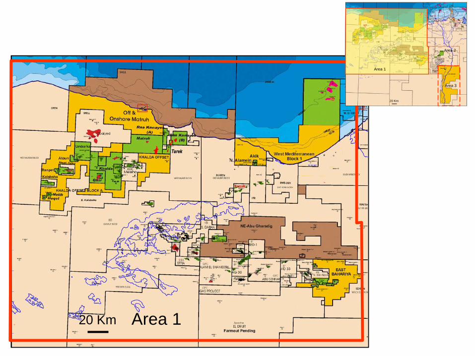
Area 120 Km Area 120 Km
Area 1
Area 2
Area 3
20 Km
Area 1
Area 2
Area 3
20 Km

Area 2
20 Km
Area 2
20 Km
Area 1
Area 2
Area 3
20 Km
Area 1
Area 2
Area 3
20 Km
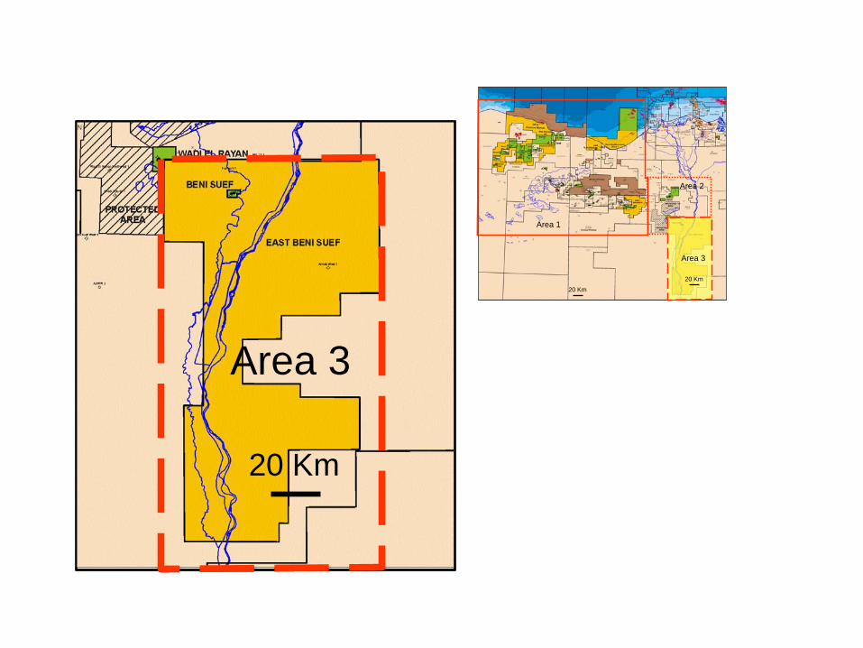
Area 3
20 Km
Area 3Area 3
20 Km
Area 1
Area 2
Area 3
20 Km
20 Km
Area 1
Area 2
Area 3
20 Km
20 Km

APPENDIX B – PHOTOS
This appendix contains an assortment of photos from various areas of the Apache Egypt operations.
Tank Containment - Qarun Oil Process Facility
Storage Tanks – Qarun Oil Process Facility
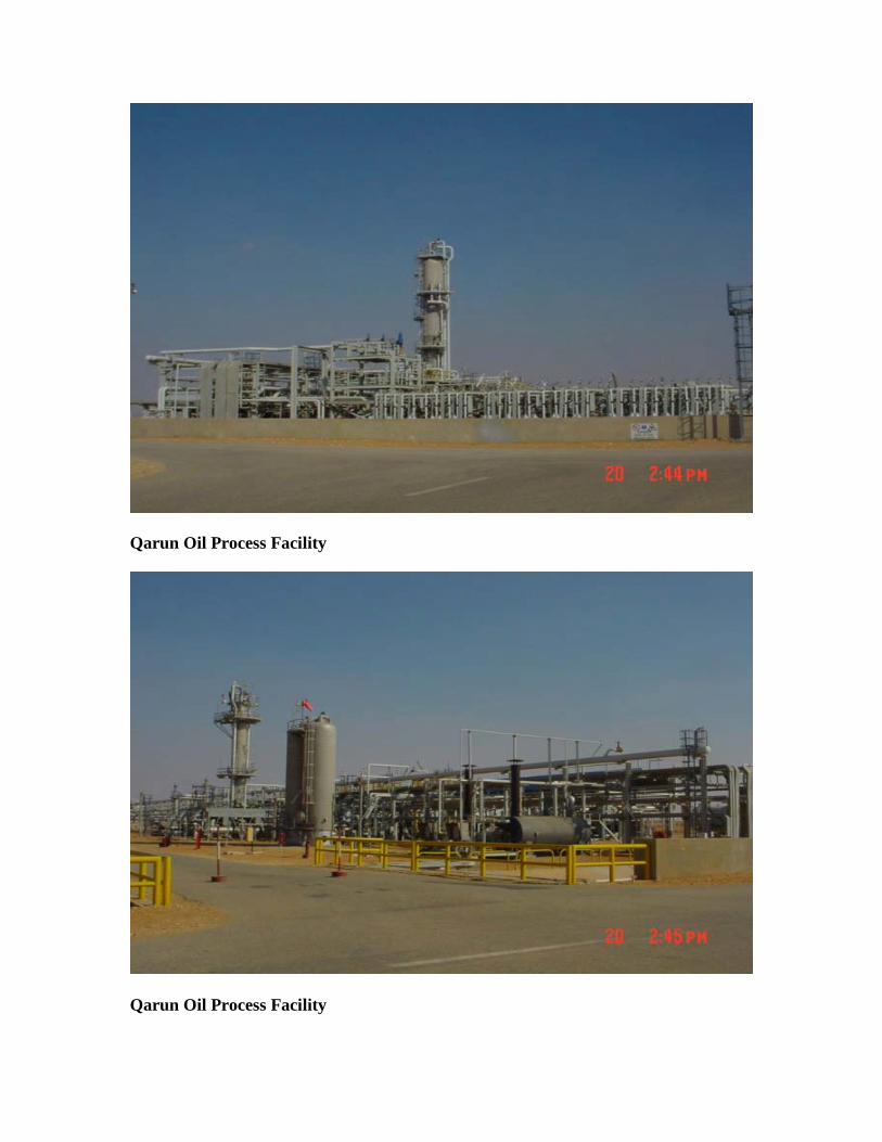
Qarun Oil Process Facility
Qarun Oil Process Facility

Salam Gas Plant (Khalda)
Salam Gas Plant (Khalda)

Umbarka Process Facility
Typical Wellhead

Tarek Gas Plant (Khalda)
Nodal Compressor Station (Khalda)
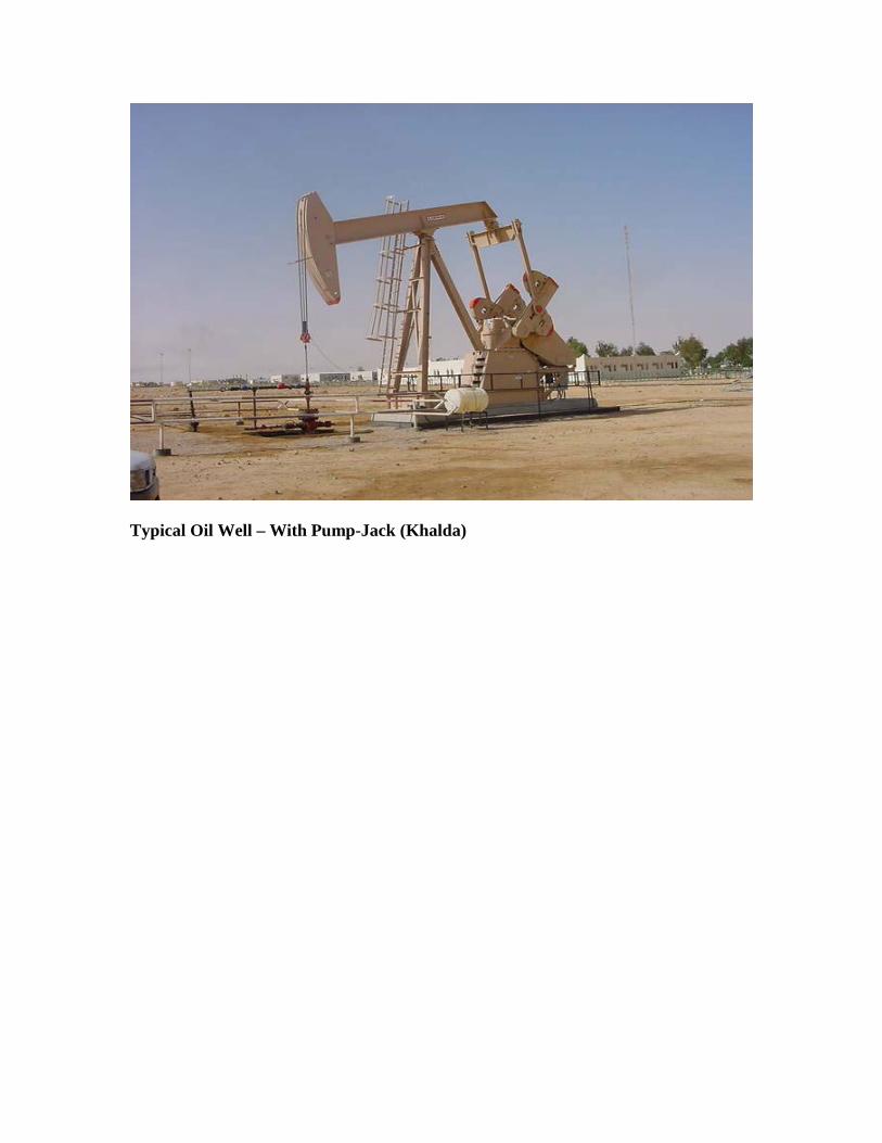
Typical Oil Well – With Pump-Jack (Khalda)

Apache Egypt Companies Typical Onshore Layout
Flare Pit
Drilling Fluid
Storage 102’ X 102’
Drilling Fluid
Storage 102’ X 102’
Generator Set
Chem
ical Storage
420 ft.
525 ft.

25
27
75
16.5
3
1910Mud Pump Pad
100.75
0.30
50
75
7510
3.5
8
20Flar
ePi
t
10
60
N
S
E W
Chkd.Rev.
B
A
Description Date Draw
Rev.01
FOR REVIEW
01.12.03
05.10.98
EGYPTIAN DRILLING COMPANY
EDC RIG 42
Number
RIG LOCATION
03R42 003App. CodeCase/Rig
Rig Name:
Title:
Drawings no.: 001 1Sheet ofSheet
Rev. no.
Dim:
01
A4Size:
Originaliy Issued by: TSReplaces Drawing no.:
Mud Pits
Meter
Rig concrete pad
14
4.10
0.95
17

80
Mud pit
0.30
70
14
18.5
70
55
45
20Flar
ePi
t
10
N
S
E W
1214
430
Originaliy Issued by: TS
04
RIG LOCATION
EDC RIG 51
EGYPTIAN DRILLING COMPANY
26.01.04
DescriptionRev. Date
FOR REVIEWA R51Chkd.Draw App. Case/Rig
Replaces Drawing no.:
Drawings no.:
Title:
Rig Name:
1001002Code Number Sheet Sheet of
Rev. no.
MeterSize:
A4
01
Dim:
2.1
3.311
11Pump Pad
33
5
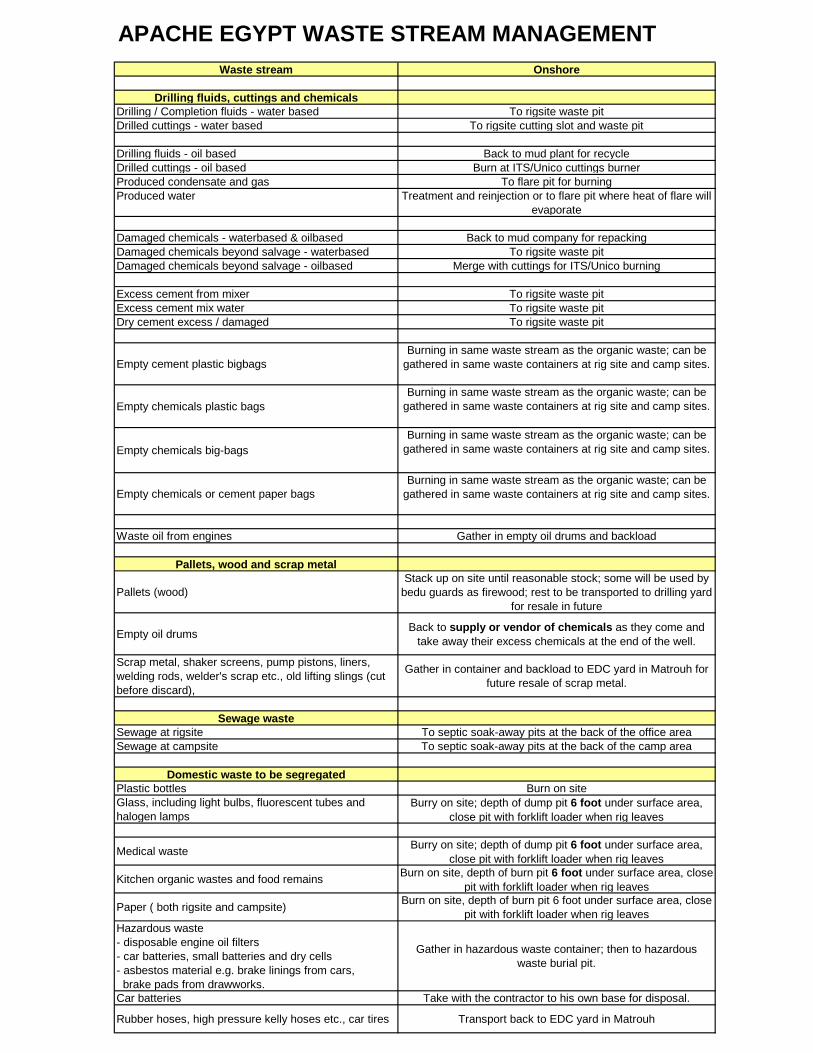
Waste stream Onshore
Drilling fluids, cuttings and chemicalsDrilling / Completion fluids - water based To rigsite waste pitDrilled cuttings - water based To rigsite cutting slot and waste pit
Drilling fluids - oil based Back to mud plant for recycleDrilled cuttings - oil based Burn at ITS/Unico cuttings burnerProduced condensate and gas To flare pit for burningProduced water Treatment and reinjection or to flare pit where heat of flare will
evaporate
Damaged chemicals - waterbased & oilbased Back to mud company for repackingDamaged chemicals beyond salvage - waterbased To rigsite waste pitDamaged chemicals beyond salvage - oilbased Merge with cuttings for ITS/Unico burning
Excess cement from mixer To rigsite waste pitExcess cement mix water To rigsite waste pitDry cement excess / damaged To rigsite waste pit
Empty cement plastic bigbagsBurning in same waste stream as the organic waste; can be
gathered in same waste containers at rig site and camp sites.
Empty chemicals plastic bagsBurning in same waste stream as the organic waste; can be
gathered in same waste containers at rig site and camp sites.
Empty chemicals big-bagsBurning in same waste stream as the organic waste; can be
gathered in same waste containers at rig site and camp sites.
Empty chemicals or cement paper bagsBurning in same waste stream as the organic waste; can be
gathered in same waste containers at rig site and camp sites.
Waste oil from engines Gather in empty oil drums and backload
Pallets, wood and scrap metal
Pallets (wood)Stack up on site until reasonable stock; some will be used by
bedu guards as firewood; rest to be transported to drilling yard for resale in future
Empty oil drums Back to supply or vendor of chemicals as they come and take away their excess chemicals at the end of the well.
Scrap metal, shaker screens, pump pistons, liners, welding rods, welder's scrap etc., old lifting slings (cut before discard),
Gather in container and backload to EDC yard in Matrouh for future resale of scrap metal.
Sewage wasteSewage at rigsite To septic soak-away pits at the back of the office areaSewage at campsite To septic soak-away pits at the back of the camp area
Domestic waste to be segregatedPlastic bottles Burn on siteGlass, including light bulbs, fluorescent tubes and halogen lamps
Burry on site; depth of dump pit 6 foot under surface area, close pit with forklift loader when rig leaves
Medical waste Burry on site; depth of dump pit 6 foot under surface area, close pit with forklift loader when rig leaves
Kitchen organic wastes and food remains Burn on site, depth of burn pit 6 foot under surface area, close pit with forklift loader when rig leaves
Paper ( both rigsite and campsite) Burn on site, depth of burn pit 6 foot under surface area, close pit with forklift loader when rig leaves
Hazardous waste- disposable engine oil filters- car batteries, small batteries and dry cells- asbestos material e.g. brake linings from cars, brake pads from drawworks.
Gather in hazardous waste container; then to hazardous waste burial pit.
Car batteries Take with the contractor to his own base for disposal.
Rubber hoses, high pressure kelly hoses etc., car tires Transport back to EDC yard in Matrouh
APACHE EGYPT WASTE STREAM MANAGEMENT