Embed Size (px)
Citation preview
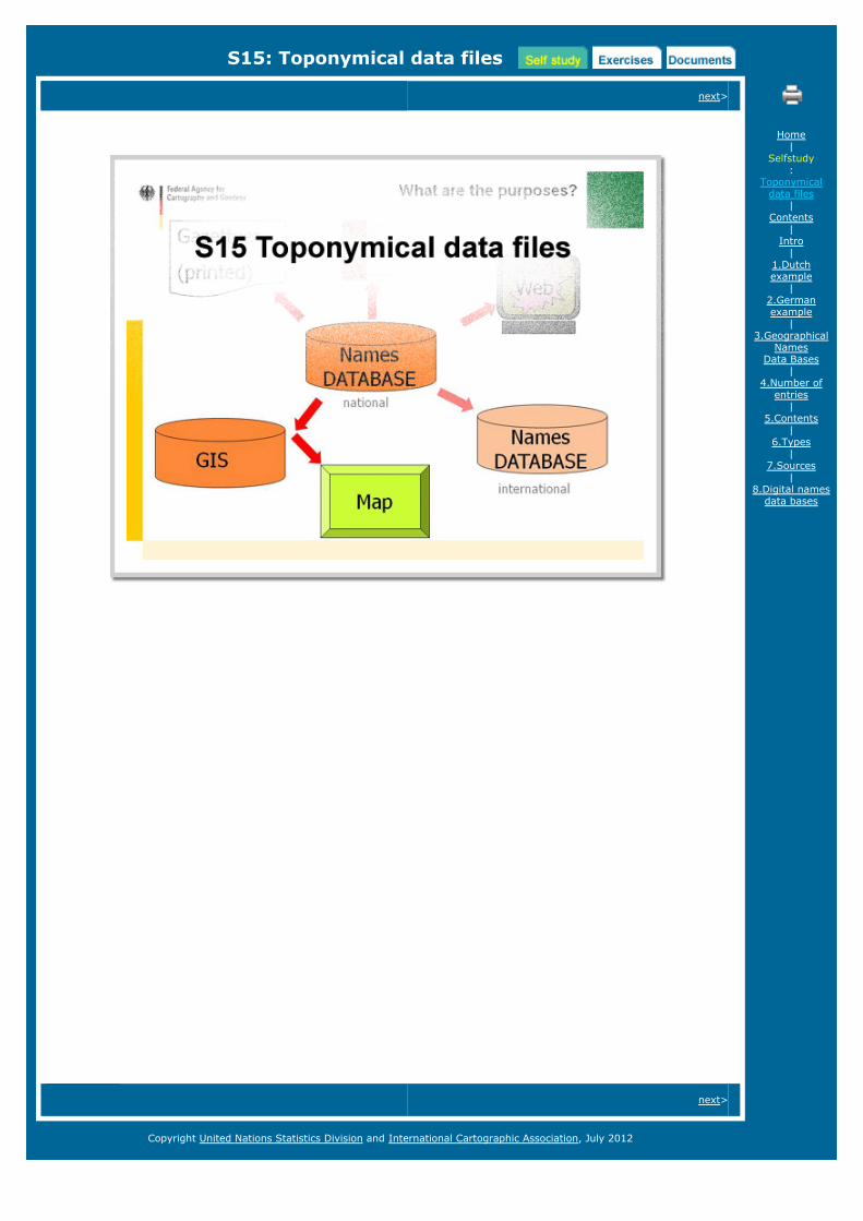
S15: Toponymical data files
next>
next>
Home|
Selfstudy:
Toponymicaldata files
|Contents
|Intro
|1.Dutchexample
|2.Germanexample
|3.Geographical
NamesData Bases
|4.Number of
entries|
5.Contents|
6.Types|
7.Sources|
8.Digital namesdata bases
Copyright United Nations Statistics Division and International Cartographic Association, July 2012

S15: Toponymical data files
TABLE OF CONTENTS <previous - next>
The content of this module is based on materials by Pier-Giorgio Zaccheddu, Andreas Illert, Bernd E.Beinstein. These materials are made available in the "documents" section.
The module contains the following chapters:
IntroductionChapter 1: Gazetteer of the NetherlandsChapter 2: Gazetteer of the Federal Republic of GermanyChapter 3: Geographical Names Data Bases (GNDB)Chapter 4: Number of entries in a GNDBChapter 5: Contents of the data basesChapter 6: Types of namesChapter 7: SourcesChapter 8: Digital names data bases
When reading through the following pages, you will come across some uncommon terms. These terms arehyperlinked to the UNGEGN Glossary of Terminology (pdf). Behind each term a number (#) is given thatcorresponds to the numbering applied in this glossary, e.g. toponymy (#344).
For exercises and documents (and literature) on this topic see respectively the "Excercises" and/or the"Documents section of this module.
The complete module can be downloaded here.
<previous - next>
Home|
Selfstudy:
Toponymicaldata files
|Contents
|Intro
|1.Dutchexample
|2.Germanexample
|3.Geographical
NamesData Bases
|4.Number of
entries|
5.Contents|
6.Types|
7.Sources|
8.Digital namesdata bases
Copyright United Nations Statistics Division and International Cartographic Association, July 2012
S15: Toponymical data files
INTRODUCTION <previous - next>
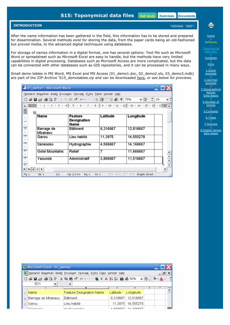
After the name information has been gathered in the field, this information has to be stored and preparedfor dissemination. Several methods exist for storing the data, from the paper cards being an old-fashionedbut proved media, to the advanced digital techniques using databases.
For storage of names information in a digital format, one has several options: Text file such as MicrosoftWord or spreadsheet such as Microsoft Excel are easy to handle, but the methods have very limitedcapabilities in digital processing. Databases such as Microsoft Access are more complicated, but the datacan be connected with other databases such as GIS repositories, and it can be processed in many ways.
Small demo tables in MS Word, MS Excel and MS Access (01_demo1.doc, 02_demo2.xls, 03_demo3.mdb)are part of the ZIP-Archive ‘S15_demotables.zip and can be downloaded here, or see below for previews.
Home|
Selfstudy:
Toponymicaldata files
|Contents
|Intro
|1.Dutchexample
|2.Germanexample
|3.Geographical
NamesData Bases
|4.Number of
entries|
5.Contents|
6.Types|
7.Sources|
8.Digital namesdata bases
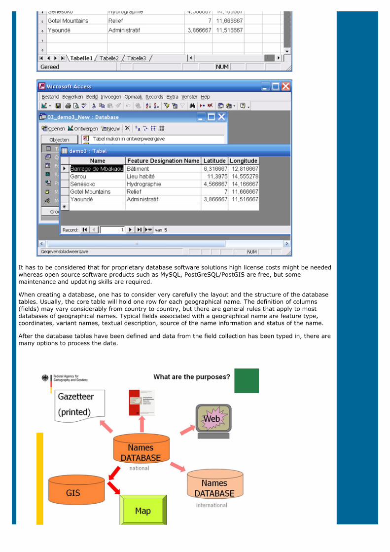
It has to be considered that for proprietary database software solutions high license costs might be neededwhereas open source software products such as MySQL, PostGreSQL/PostGIS are free, but somemaintenance and updating skills are required.
When creating a database, one has to consider very carefully the layout and the structure of the databasetables. Usually, the core table will hold one row for each geographical name. The definition of columns(fields) may vary considerably from country to country, but there are general rules that apply to mostdatabases of geographical names. Typical fields associated with a geographical name are feature type,coordinates, variant names, textual description, source of the name information and status of the name.
After the database tables have been defined and data from the field collection has been typed in, there aremany options to process the data.
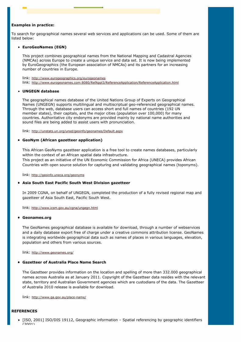
Examples in practice:
To search for geographical names several web services and applications can be used. Some of them arelisted below:
EuroGeoNames (EGN)
This project combines geographical names from the National Mapping and Cadastral Agencies(NMCAs) across Europe to create a unique service and data set. It is now being implementedby EuroGeographics (the European association of NMCAs) and its partners for an increasingnumber of countries in Europe.
link: http://www.eurogeographics.org/eurogeonameslink: http://www.eurogeonames.com:8080/RefAppl3/ReferenceApplication/ReferenceApplication.html
UNGEGN database
The geographical names database of the United Nations Group of Experts on GeographicalNames (UNGEGN) supports multilingual and multiscriptual geo-referenced geographical names.Through the web, database users can access short and full names of countries (192 UNmember states), their capitals, and the major cities (population over 100,000) for manycountries. Authoritative city endonyms are provided mainly by national name authorities andsound files are being added to assist users with pronunciation.
link: http://unstats.un.org/unsd/geoinfo/geonames/Default.aspx
GeoNym (African gazetteer application)
This African GeoNyms gazetteer application is a free tool to create names databases, particularlywithin the context of an African spatial data infrastructure. This project as an initiative of the UN Economic Commission for Africa (UNECA) provides AfricanCountries with open source solution for capturing and validating geographical names (toponyms).
link: http://geoinfo.uneca.org/geonyms
Asia South East Pacific South West Division gazetteer
In 2009 CGNA, on behalf of UNGEGN, completed the production of a fully revised regional map andgazetteer of Asia South East, Pacific South West.
link: http://www.icsm.gov.au/cgna/ungegn.html
Geonames.org
The GeoNames geographical database is available for download, through a number of webservicesand a daily database export free of charge under a creative commons attribution license. GeoNamesis integrating worldwide geographical data such as names of places in various languages, elevation,population and others from various sources.
link: http://www.geonames.org/
Gazetteer of Australia Place Name Search
The Gazetteer provides information on the location and spelling of more than 332.000 geographicalnames across Australia as at January 2011. Copyright of the Gazetteer data resides with the relevantstate, territory and Australian Government agencies which are custodians of the data. The Gazetteerof Australia 2010 release is available for download.
link: http://www.ga.gov.au/place-name/
REFERENCES
[ISO, 2001] ISO/DIS 19112, Geographic information – Spatial referencing by geographic identifiers(2001)
(2001)
[UNCSGN, 2002] United Nations Resolution VIII/6 (2002), Integration of Geographical Names Datainto National and Regional Spatial Data Infrastructures, Eighth United Nations Conference on theStandardization of Geographical Names (2002)
[OGC, 2005] Open Geospatial Consortium (OGC), OGC Web Services Common Specification (2005)
[INSPIRE, 2007] Directive 2007/2/EC of the European Parliament and of the Council of 14 March2007, establishing an infrastructure for spatial information in the European Community (INSPIRE),Brussels, 25.4.2007, Official Journal of the European Union (L108/1), (2007)
[INSPIRE, 2009] INSPIRE Data Specification on Geographical Names – Guidelines (2009)
[OGC, 2012] Open Geospatial Consortium (OGC), Gazetteer Service - Application Profile of the WebFeature Service Best Practice, OGC 11-122r1 (2012)
[UNCSGN, 2012-1] E/CONF.101/57 The Four Faces of Toponymic Gazetteers, Tenth United NationsConference on the Standardization of Geographical Names
[UNCSGN, 2012-2] E/CONF.101/55 UNSDI Gazetteer Framework for Social Protection in Indonesia,Tenth United Nations Conference on the Standardization of Geographical Names
<previous - next>
Copyright United Nations Statistics Division and International Cartographic Association, July 2012
S15: Toponymical data files
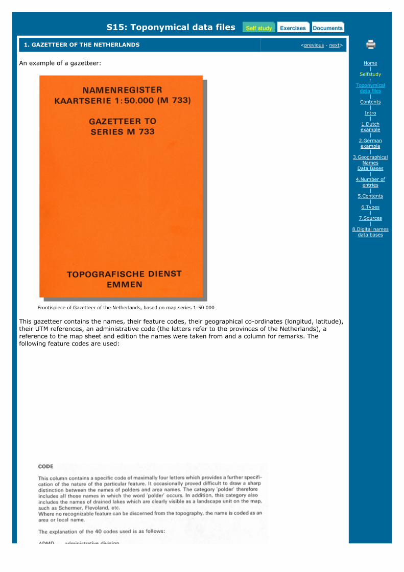
1. GAZETTEER OF THE NETHERLANDS <previous - next>
An example of a gazetteer:
Frontispiece of Gazetteer of the Netherlands, based on map series 1:50 000
This gazetteer contains the names, their feature codes, their geographical co-ordinates (longitud, latitude),their UTM references, an administrative code (the letters refer to the provinces of the Netherlands), areference to the map sheet and edition the names were taken from and a column for remarks. Thefollowing feature codes are used:
Home|
Selfstudy:
Toponymicaldata files
|Contents
|Intro
|1.Dutchexample
|2.Germanexample
|3.Geographical
NamesData Bases
|4.Number of
entries|
5.Contents|
6.Types|
7.Sources|
8.Digital namesdata bases
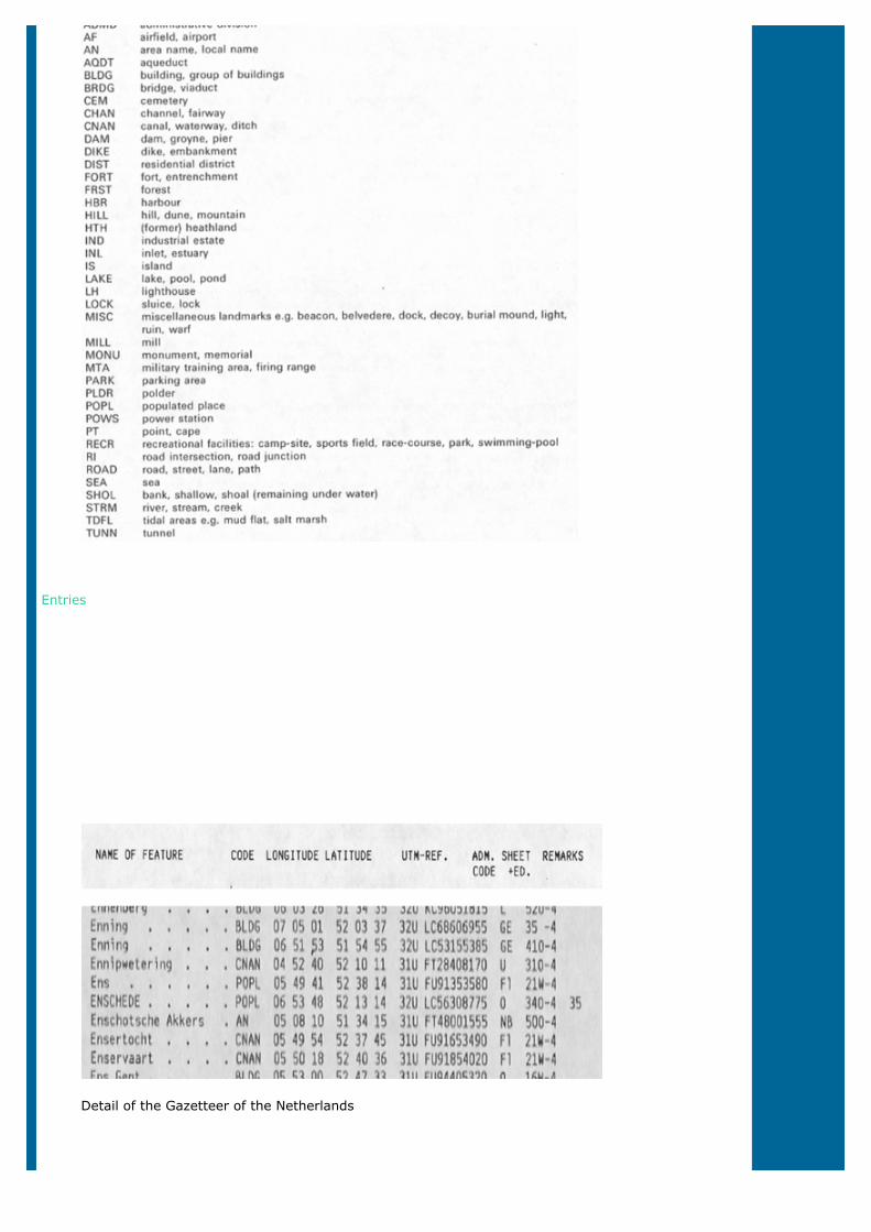
Entries
Detail of the Gazetteer of the Netherlands

<previous - next>
Copyright United Nations Statistics Division and International Cartographic Association, July 2012
S15: Toponymical data files
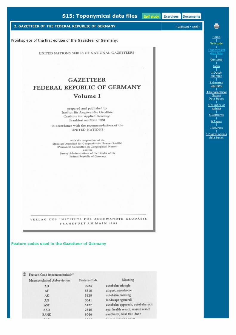
2. GAZETTEER OF THE FEDERAL REPUBLIC OF GERMANY <previous - next>
Frontispiece of the first edition of the Gazetteer of Germany:
Feature codes used in the Gazetteer of Germany
Home|
Selfstudy:
Toponymicaldata files
|Contents
|Intro
|1.Dutchexample
|2.Germanexample
|3.Geographical
NamesData Bases
|4.Number of
entries|
5.Contents|
6.Types|
7.Sources|
8.Digital namesdata bases
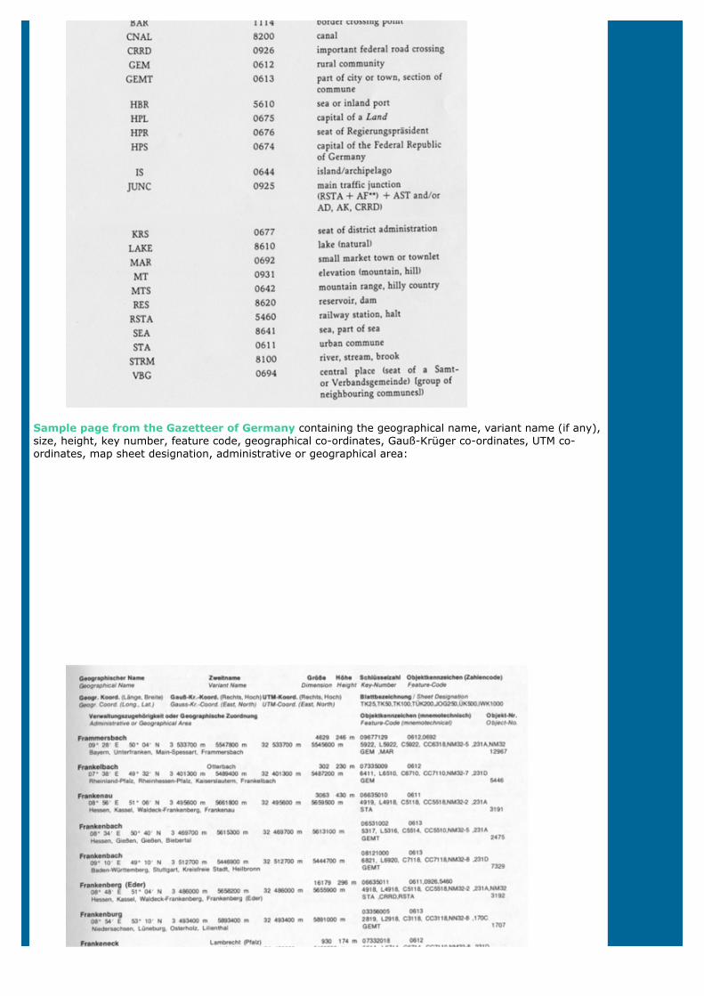
Sample page from the Gazetteer of Germany containing the geographical name, variant name (if any),size, height, key number, feature code, geographical co-ordinates, Gauß-Krüger co-ordinates, UTM co-ordinates, map sheet designation, administrative or geographical area:
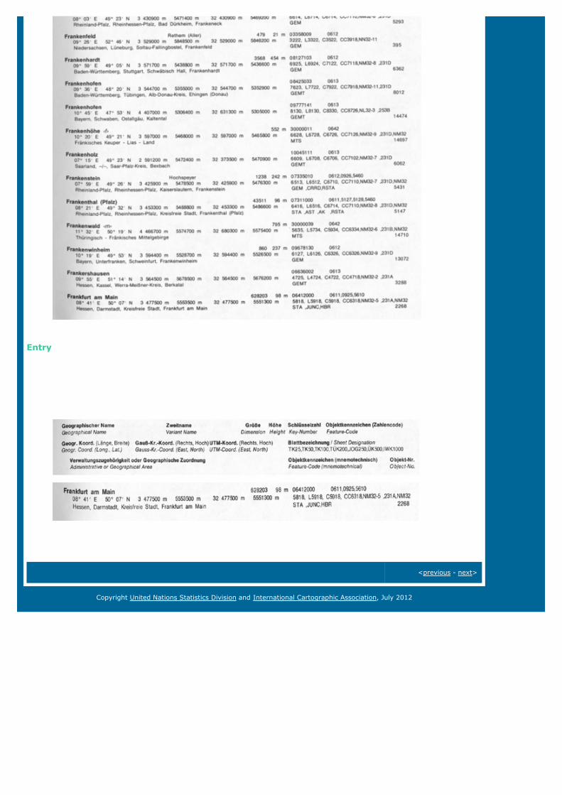
Entry
<previous - next>
Copyright United Nations Statistics Division and International Cartographic Association, July 2012
S15: Toponymical data files
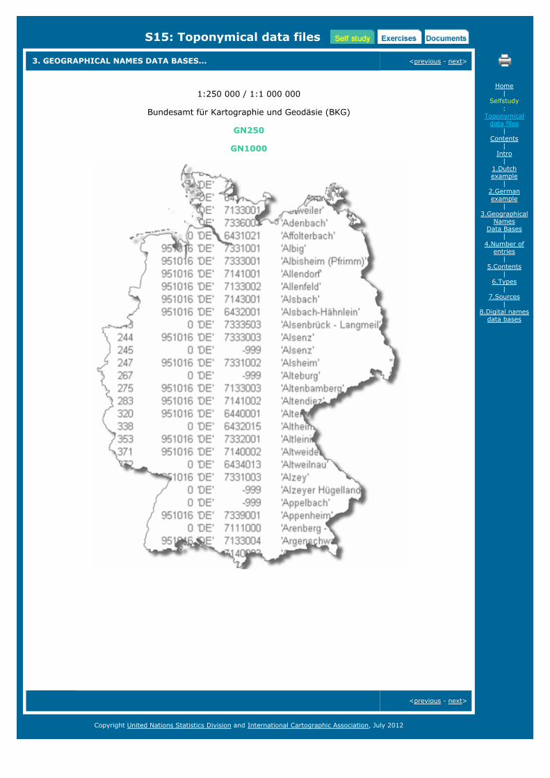
3. GEOGRAPHICAL NAMES DATA BASES... <previous - next>
1:250 000 / 1:1 000 000
Bundesamt für Kartographie und Geodäsie (BKG)
GN250
GN1000
<previous - next>
Home|
Selfstudy:
Toponymicaldata files
|Contents
|Intro
|1.Dutchexample
|2.Germanexample
|3.Geographical
NamesData Bases
|4.Number of
entries|
5.Contents|
6.Types|
7.Sources|
8.Digital namesdata bases
Copyright United Nations Statistics Division and International Cartographic Association, July 2012
S15: Toponymical data files
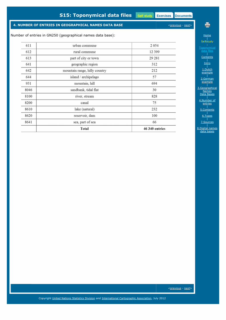
4. NUMBER OF ENTRIES IN GEOGRAPHICAL NAMES DATA BASE <previous - next>
Number of entries in GN250 (geographical names data base):
<previous - next>
Home|
Selfstudy:
Toponymicaldata files
|Contents
|Intro
|1.Dutchexample
|2.Germanexample
|3.Geographical
NamesData Bases
|4.Number of
entries|
5.Contents|
6.Types|
7.Sources|
8.Digital namesdata bases
Copyright United Nations Statistics Division and International Cartographic Association, July 2012
S15: Toponymical data files
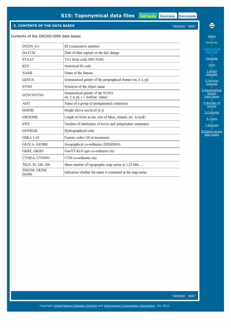
5. CONTENTS OF THE DATA BASES <previous - next>
Contents of the GN250/1000 data bases
<previous - next>
Home|
Selfstudy:
Toponymicaldata files
|Contents
|Intro
|1.Dutchexample
|2.Germanexample
|3.Geographical
NamesData Bases
|4.Number of
entries|
5.Contents|
6.Types|
7.Sources|
8.Digital namesdata bases
Copyright United Nations Statistics Division and International Cartographic Association, July 2012
S15: Toponymical data files
6. TYPES OF NAMES <previous - next>
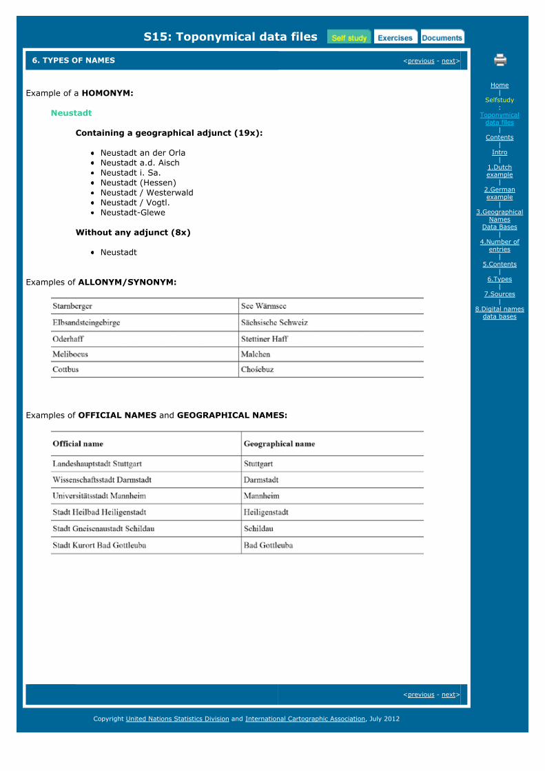
Example of a HOMONYM:
Neustadt
Containing a geographical adjunct (19x):
Neustadt an der OrlaNeustadt a.d. AischNeustadt i. Sa.Neustadt (Hessen)Neustadt / WesterwaldNeustadt / Vogtl.Neustadt-Glewe
Without any adjunct (8x)
Neustadt
Examples of ALLONYM/SYNONYM:
Examples of OFFICIAL NAMES and GEOGRAPHICAL NAMES:
<previous - next>
Home|
Selfstudy:
Toponymicaldata files
|Contents
|Intro
|1.Dutchexample
|2.Germanexample
|3.Geographical
NamesData Bases
|4.Number of
entries|
5.Contents|
6.Types|
7.Sources|
8.Digital namesdata bases
Copyright United Nations Statistics Division and International Cartographic Association, July 2012
S15: Toponymical data files
7. SOURCES <previous - next>
Official communal gazetteers
Official statistical reports of the Länder
Official statistical codes and data of the population of the communes and the adminstrative districts
Topographic data of the survey administrations of the Länder (Parts of cities and towns, geographicregions, hydrography, ...)
<previous - next>
Home|
Selfstudy:
Toponymicaldata files
|Contents
|Intro
|1.Dutchexample
|2.Germanexample
|3.Geographical
NamesData Bases
|4.Number of
entries|
5.Contents|
6.Types|
7.Sources|
8.Digital namesdata bases
Copyright United Nations Statistics Division and International Cartographic Association, July 2012
S15: Toponymical data files
8. DIGITAL NAMES DATA BASES <previous
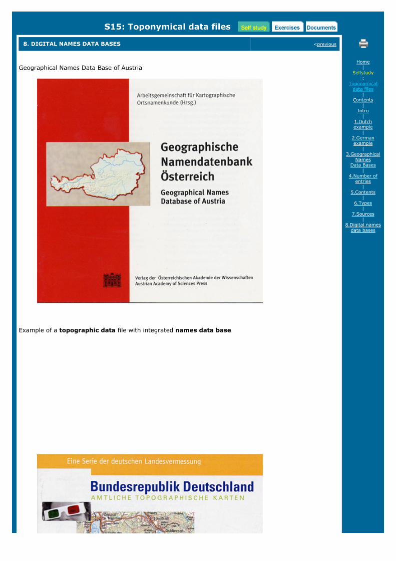
Geographical Names Data Base of Austria
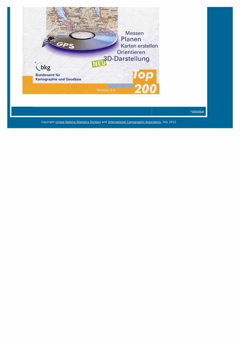
Example of a topographic data file with integrated names data base
Home|
Selfstudy:
Toponymicaldata files
|Contents
|Intro
|1.Dutchexample
|2.Germanexample
|3.Geographical
NamesData Bases
|4.Number of
entries|
5.Contents|
6.Types|
7.Sources|
8.Digital namesdata bases
<previous
Copyright United Nations Statistics Division and International Cartographic Association, July 2012
E15: Toponymical data files
AVAILABLE EXERCISES next>
Exercise 1: Creating a Geographical Names Database, and producing Gazetteers and Maps
next>
Home|
Exercises:
Toponymicaldata files
|1.Creating aGeographical
NamesDatabase,
Gazetteers andMaps
Copyright United Nations Statistics Division and International Cartographic Association, July 2012
E15: Toponymical data files
EXERCISE 1: CREATING A GEOGRAPHICAL NAMES DATABASE AND ..... <previous
The exercise which can be downloaded as pdf-file deals with advanced digital techniques usingdatabases. If exercised properly, the layout and structure of a names database will beunderstood better, data, e.g. from a field collection, can be inserted into a database, agazetteer be printed from the database and, if applicable, a map with the geographical namesin a Geographical Information System (GIS) be created.
The exercise ‘S15_exercise_database.pdf’ can be downloaded as pdf-file here.
The demo table ‘Gazetteer-DB_Cameroon.mdb’ is part of the ZIP-Archive ‘S15_demotables.zipand can be downloaded here.
For the near future it is foreseen to support the exercise with a downloadable open sourcesoftware solution too, which could be used alternatively to create database and upload the datain a GIS.
Meanwhile a list of recommendations for open source software solutions‘S15_OpenSourceSoftwareList.pdf’ has been compiled and can be downloaded here.
<previous
Home|
Exercises:
Toponymicaldata files
|1.Creating aGeographical
NamesDatabase,
Gazetteers andMaps
Copyright United Nations Statistics Division and International Cartographic Association, July 2012
D15: Toponymical data files
DOCUMENTS AND LITERATURE
Available documents:
D15-01: Zaccheddu, P.G. (2006). Database management. Power point presentation, Maputotoponymy course, Maputo 2006.
Literature:
Mittermaier, R. (2006). Austrian Names Data Base (GEONAM). Proceedings UNGEGN Toponymycourse Vienna 2006 (on DGSD website).
[ISO, 2001] ISO/DIS 19112, Geographic information – Spatial referencing by geographic identifiers(2001)
[UNCSGN, 2002] United Nations Resolution VIII/6 (2002), Integration of Geographical Names Datainto National and Regional Spatial Data Infrastructures, Eighth United Nations Conference on theStandardization of Geographical Names (2002)
[OGC, 2005] Open Geospatial Consortium (OGC), OGC Web Services Common Specification (2005)
[INSPIRE, 2007] Directive 2007/2/EC of the European Parliament and of the Council of 14 March2007, establishing an infrastructure for spatial information in the European Community (INSPIRE),Brussels, 25.4.2007, Official Journal of the European Union (L108/1), (2007)
[INSPIRE, 2009] INSPIRE Data Specification on Geographical Names – Guidelines (2009)
[OGC, 2012] Open Geospatial Consortium (OGC), Gazetteer Service - Application Profile of the WebFeature Service Best Practice, OGC 11-122r1 (2012)
[UNCSGN, 2012-1] E/CONF.101/57 The Four Faces of Toponymic Gazetteers, Tenth United NationsConference on the Standardization of Geographical Names
[UNCSGN, 2012-2] E/CONF.101/55 UNSDI Gazetteer Framework for Social Protection in Indonesia,Tenth United Nations Conference on the Standardization of Geographical Names
Online resources:
EuroGeoNamesEuroGeoNames Reference ApplicationUNGEGN Database GeoNym (African gazetteer application) Asia South East Pacific South West Division gazetteer Geonames.orgGazetteer of Australia Place Name SearchThe following deliverables are available through the EuroGeoNames (EGN) website (underdownloads):
EGN Deliverable D1.7, Final Report D1.7 (2009)EGN Deliverable D3.3, EGN Metadata profile (2008)EGN Deliverable D4.2e, Data model conceptual schema & documentation (2008)EGN Deliverable D6.5, EGN Web Services profile - specifications for implementation2008)EGN Deliverable D7.4, Documentation EGN Web GIS Reference Application (2009)EGN Deliverable D8.2, EGN ArcGIS Extension Documentation (2009)EGN Deliverable D11.2, Implementation Plan (2009)
The United Nations sell the following publications which also can be downloaded from theUNGEGN website:
Glossary of Terms for the Standardization of Geographical Names (New York 2002) / pdf
Home|
Documents:
Toponymicaldata files

Manual for the national standardization of geographical names (UN - Ecosoc, New York,2006 ST/ESA/STAT/SERM/88 Sales No. E.06.XVII.7 ISBN 92-1-161490-2, available inthe 6 UN languages) / pdf
Technical reference manual for the standardization of geographical names (New York,2007) / pdf
Resolutions adopted at the nine UN Conferences on the standardization of geographicalnames (English (pdf) / French (pdf)
Copyright United Nations Statistics Division and International Cartographic Association, July 2012