Embed Size (px)
Citation preview
forty-five.com / papers / 150
Sacred States of America

Ellen R. Hartman Reviewed by Jesse Vogler
Sacred sites transcend time through association with unique geological features or environmental conditions, and their importance is conveyed through myths and constructed markers. Of known sacred sites, most are long-established yet the rationale for their selection is now forgotten. Archaeologists can interpret such sites, speculating on how they were used, but, despite those conjectures, motives directing site selection and formation remain largely unanswerable.
To explore how sacred sites might be initially charted and their meanings developed, this project uses geomancy to locate ten future sacred sites in the United States. Interactions with those sites are then prompted to initiate a process that generates their sacredness.
Geomancy is a field of inquiry and interpretation based on interpreting the earth’s energies. Depending on the practitioner, it is used either to divine the future by asking questions1 or to identify sacred geometries within landscape.2 Interestingly, neither of those two subfields recognizes the methods of the other as valid. I use both geomantic approaches first to predict the locations of future sacred sites and then to identify the sacred features at those locations.3
Predicting the locations of future sacred sites is a multi-phased process, the first step of which is to cast geomantic charts to determine whether such sites can be located and, if so, how many are possble.
To locate future sacred sites in the United States, I engaged that first step and concluded that there would be ten. I then cast ten sets of ten points on a current map of the United States. Next, lines were drawn sequentially to connect the points in each set. The resulting geometries were analyzed to determine broad patterns and relationships between all the points. Based on that process, ten triangular areas were established by identifying clusters of similar points, such as three of the same cast point (7,7,7) or a sequence of numbers (2,3,4). Those points were plotted in GIS, and the geographic centroid of each triangle was calculated to pinpoint the location of each of the ten future sacred sites.
Situating each site geographically provided physical characteristics that were used to guide more specific geomantic inquiries. For each site, multiple geomantic charts were cast asking about the future of the place and what type of sacred elements would come to define it. The geomantic divination predictions were cross-compared with an analysis of each site’s physical characteristics to arrive at a unique sacred geometry for each location. The form for each site was related to a familiar type historically associated with sacred sites: omphalos, cairn, gates of hell, megalith, holy mountain, sacred grove, earthwork, temenos, spring and well, or geoglyph.
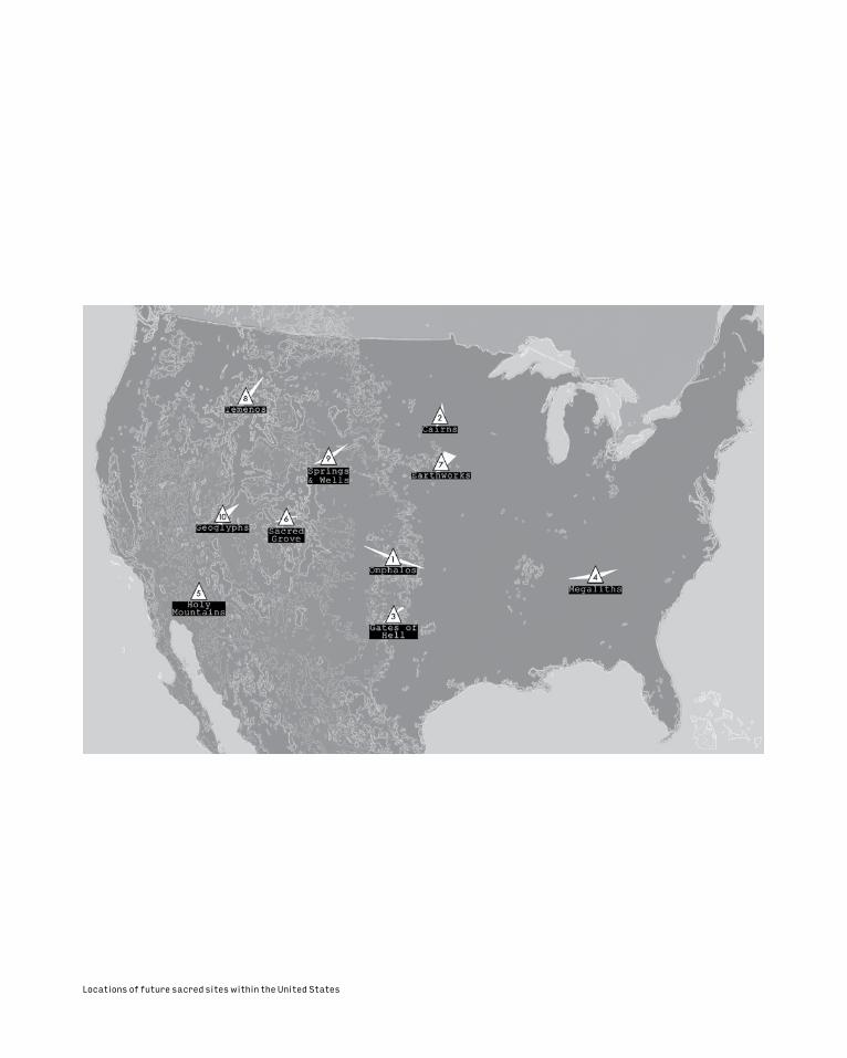
Locations of future sacred sites within the United States

The sacred sites and their future forms were then plotted in Google Earth, a platform chosen because of its capacity to render three-dimensional terrain, ease of navigation through dynamic viewpoints, and its historical imagery slider. With the ability to render buildings, objects, and landscape features—including trees—in 3D, Google Earth has the potential to become a highly detailed, if not real-time enabled, digital version of the physical world. Mapping future sacred sites in Google Earth provides the most digital longevity and the potential to see the sites change through time as geospatial data collection, computation, and visualization continue to become more sophisticated.
The sacred sites and areas located in Google Earth inform the Sacred States of America map, which charts the remains of sacred infrastructures that exist in the distant future with implications for reformed territories. Supplementing the Google Earth file is a printable pilgrimage map and corresponding social media campaign that directs tourists to the Sacred States of America to initiate the process of transforming and developing meaning in those landscapes.
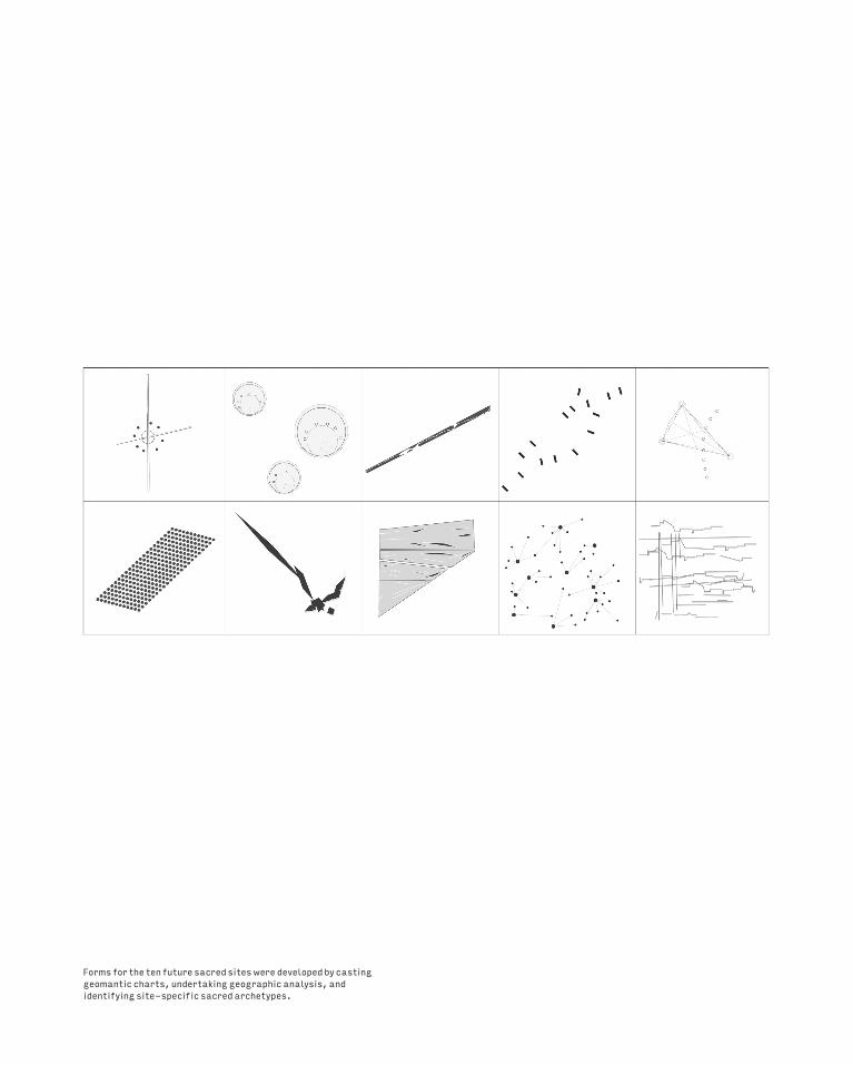
Forms for the ten future sacred sites were developed by casting geomantic charts, undertaking geographic analysis, and identifying site-specific sacred archetypes.
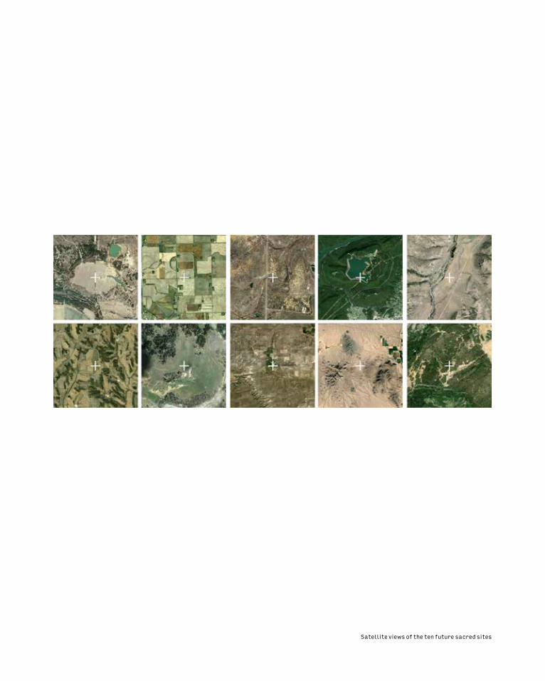
Satellite views of the ten future sacred sites
forty-five.com / papers / 150
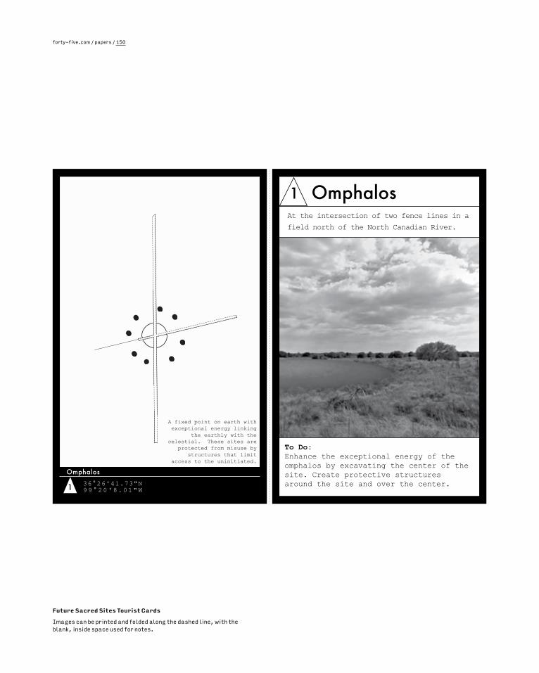
Future Sacred Sites Tourist Cards
Images can be printed and folded along the dashed line, with the blank, inside space used for notes.
1 36°26'41.73"N 99°20'8.01"W
Omphalos
A fixed point on earth with exceptional energy linking
the earthly with the celestial. These sites are
protected from misuse by structures that limit
access to the uninitiated.
1 Omphalos
To Do: Enhance the exceptional energy of the omphalos by excavating the center of the site. Create protective structures around the site and over the center.
At the intersection of two fence lines in a
field north of the North Canadian River.
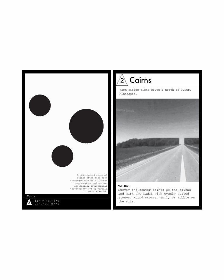
2 44°17'32.04"N96°7'11.07"W
Cairns
A constructed mound of stones often made from
scavenged materials. Cairns are used as markers for navigation, astronomical
observations, or as portals to the Otherworld.
2 Cairns
To Do: Survey the center points of the cairns and mark the radii with evenly spaced stones. Mound stones, soil, or rubble on the site.
Farm fields along Route 8 north of Tyler, Minnesota.
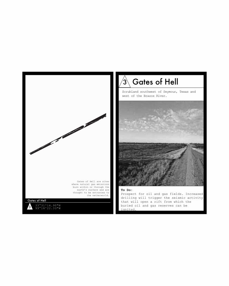
3 33°31'14.90"N99°18'22.33"W
Gates of Hell
Gates of Hell are sites where natural gas emissions burn within or through the
earth’s surface and are thought to be entrances to
the netherworld.
3 Gates of Hell
To Do: Prospect for oil and gas fields. Increased drilling will trigger the seismic activity that will open a rift from which the buried oil and gas reserves can be ignited.
Scrubland southwest of Seymour, Texas and west of the Brazos River.
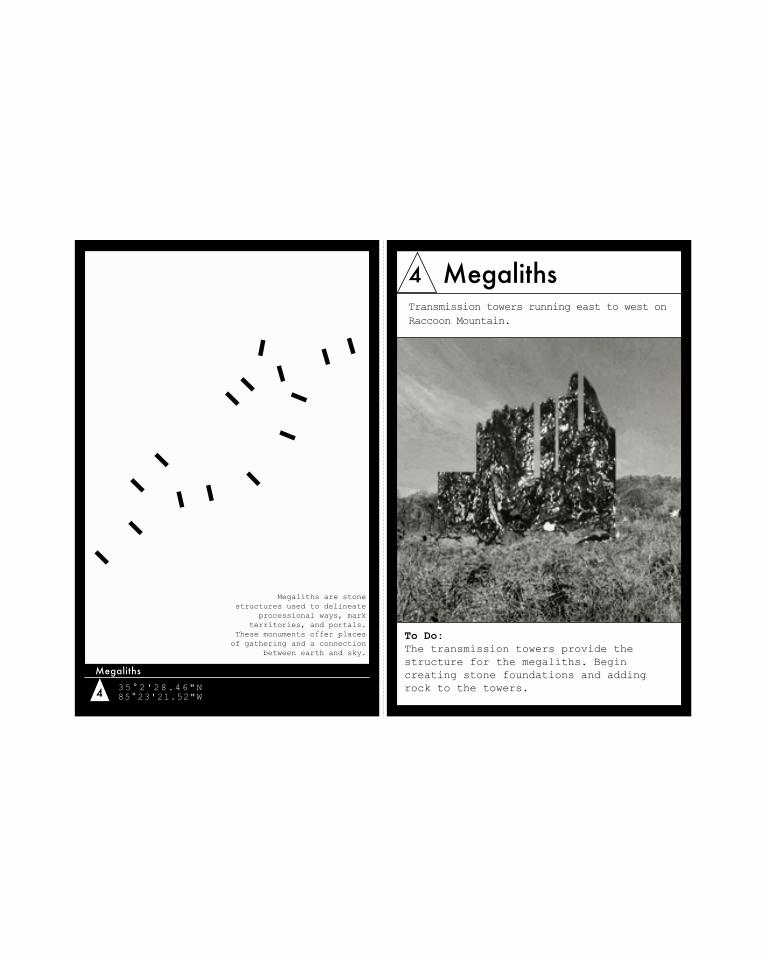
4 35°2'28.46"N85°23'21.52"W
Megaliths
Megaliths are stone structures used to delineate
processional ways, mark territories, and portals.
These monuments offer places of gathering and a connection
between earth and sky.
4 Megaliths
To Do: The transmission towers provide the structure for the megaliths. Begin creating stone foundations and adding rock to the towers.
Transmission towers running east to west on Raccoon Mountain.
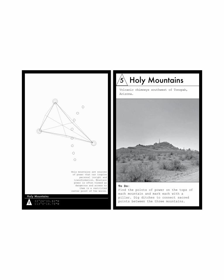
5 33°26'33.82"N113°0'14.76"W
Holy Mountains
Holy mountains are sources of power that can inspire
personal insight and transformation. Mountain power is often viewed as dangerous and access to
them is a restricted center point of the world.
5 Holy Mountains
To Do: Find the points of power on the tops of each mountain and mark each with a pillar. Dig ditches to connect sacred points between the three mountains.
Volcanic chimneys southwest of Tonopah, Arizona.
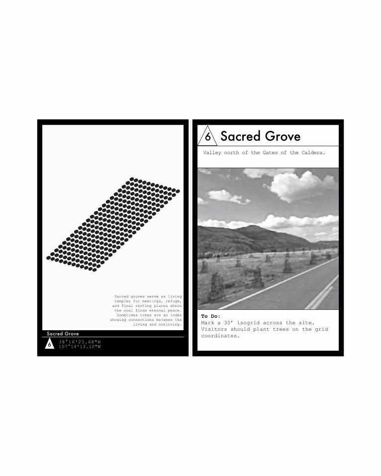
6 38°16'23.68"N107°14'13.10"W
Sacred Grove
Sacred groves serve as living temples for meetings, refuge, and final resting places where the soul finds eternal peace. Sometimes trees are an index
showing connections between the living and nonliving.
6 Sacred Grove
To Do: Mark a 30’ isogrid across the site. Visitors should plant trees on the grid coordinates.
Valley north of the Gates of the Caldera.
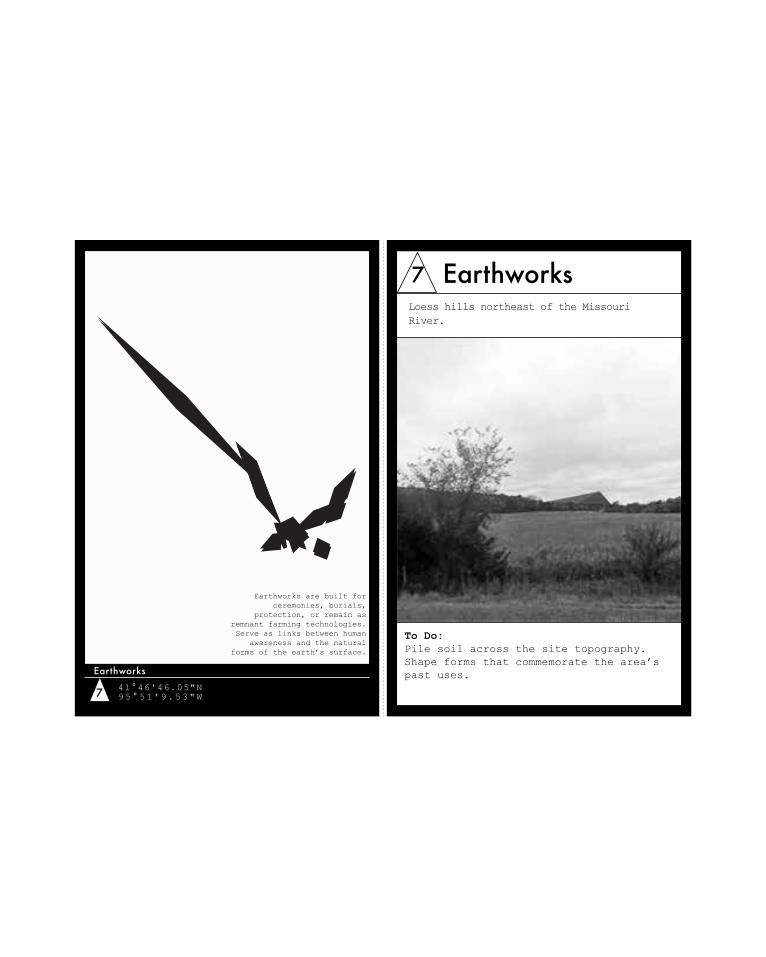
7 41°46'46.05"N95°51'9.53"W
Earthworks
Earthworks are built for ceremonies, burials,
protection, or remain as remnant farming technologies. Serve as links between human
awareness and the natural forms of the earth’s surface.
7 Earthworks
To Do: Pile soil across the site topography. Shape forms that commemorate the area’s past uses.
Loess hills northeast of the Missouri River.
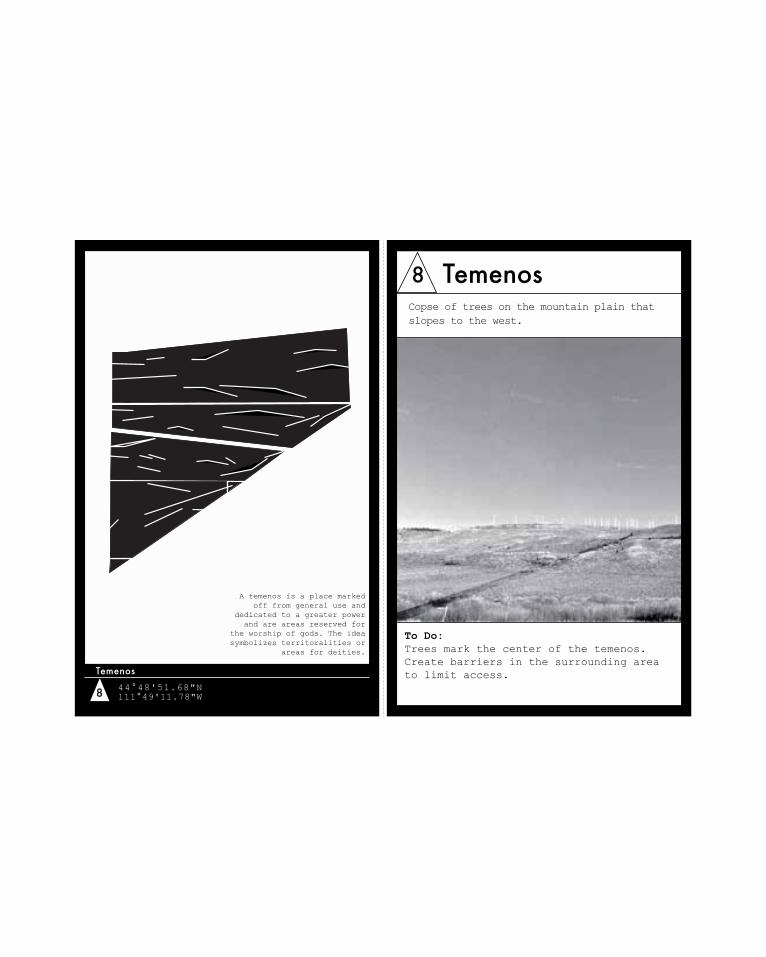
8 44°48'51.68"N111°49'11.78"W
Temenos
A temenos is a place marked off from general use and
dedicated to a greater power and are areas reserved for
the worship of gods. The idea symbolizes territoralities or
areas for deities.
8 Temenos
To Do: Trees mark the center of the temenos. Create barriers in the surrounding area to limit access.
Copse of trees on the mountain plain that slopes to the west.
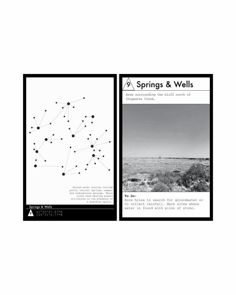
9 41°50'47.87"N104°31'4.77"W
Springs & Wells
Sacred water sources include pools, natural springs, seeps, and underground springs. These
sites have healing powers attributed to the presence of
a guardian spirit.
9 Springs & Wells
To Do: Bore holes to search for groundwater or to collect rainfall. Mark sites where water is found with piles of stone.
Area surrounding the bluff north of Chugwater Creek.
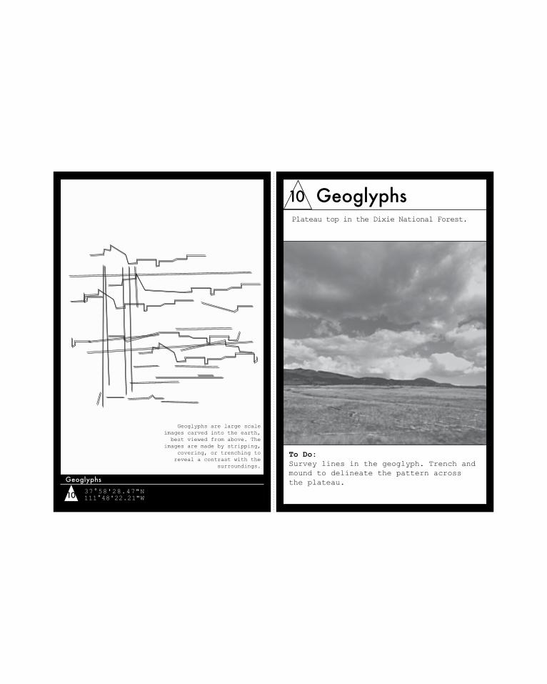
10 37°58'28.47"N111°48'22.21"W
Geoglyphs
Geoglyphs are large scale images carved into the earth,
best viewed from above. The images are made by stripping,
covering, or trenching to reveal a contrast with the
surroundings.
10 Geoglyphs
To Do: Survey lines in the geoglyph. Trench and mound to delineate the pattern across the plateau.
Plateau top in the Dixie National Forest.

forty-five.com / papers / 150 Sacred States of America Pilgrimage Map
A map (.pdf format) to be printed double-sided and used as a guide in travel can be downloaded at:
http://forty-five.com/media/uploads/Hartman-SacredStates-PilgrimageMap.pdf
Sacred States of America on Google Earth
A placemark file (.kmz format) for use on Google Earth can be downloaded by following the link at:
http://ellen-hartman.com/SSoA/
N.B. User must have Google Earth application to access placemark file.
Review
By Jesse Vogler
Architecture, in its positivist and materialist aspirations, has long had an uncomfortable relationship with divination. From the Roman augur, to the nineteenth-century land booster, to the twentieth-century real estate salesman, architecture’s foundings have long relied on auspicious narrators of profit or doom. The ancient Roman historian Livy, commenting on what he knew to be always, already at stake in the projective project of architecture, asked: auspiciis hanc urbem conditam esse, auspiciis bello ac pace domi militiaeque omnia geri, quis est qui ignoret? [Who does not know that this city was founded only after taking the divinations, that everything in war and in peace, at home and abroad, was done only after taking the divinations?].4 Who does not know, indeed. Or, rather, how is it that we have forgotten? And so we might reframe the geomancy that gives us the Sacred States of America as a pragmatic divination—one that, as Virgil reminds us, does not rest on the inspiration of the oracle but on knowledge and execution of a skillful system.5
And perhaps it is here, in carrying out the meter of an epistemic technology, that divination and modernity converge. The framework that brings us the omphalos, the megalith, the sacred grove, and the temenos is perhaps not as far as we might think from that which gives us the point grid, regulating lines, and the abstract geometry of the modern city. Reading and responding to the flight of birds, on one hand, and the flight of capital, on the other: each of those practices depends on faith.
But still, we are told to cast our lot with the rationalist diagrams of modernity over these agents of conjecture. Hartman has cast her lot differently, as have I, and she invites us to join in a new founding, from which we can measure our distance in space, time, and orientation from an estrangement that may not be quite as neat as we originally suspected. After all, what is it that we provide, what particular currency is it that we architects circulate, if not that divine scrip of speculation?

forty-five.com / papers / 150
1 John Michael Greer, Earth Divination, Earth Magic: A Practical Guide to Geomancy (St. Paul, MN: Llewellyn Publications, 1999).
2 Nigel Pennick, The Ancient Science of Geomancy: Man in Harmony with the Earth (London: Thames and Hudson, 1979).
3 For a more in-depth discussion on geomantic divination as a tool for landscape inquiry, see Ellen Hartman, “Savior City,” in (Non-)Essential Knowledge for (New) Architecture [306090 15], ed. David L. Hays (Princeton, NJ: 306090/Princeton Architectural Press, 2013), 50-79.
4 Titus Livius (Livy), The History of Rome, Book VI, Chapter 41.
5 See Justus Frederick Holstein, Rites and Ritual Acts as Prescribed by the Roman Religion According to the Commentary of Servius on Vergil's Aeneid (Thesis, New York University, 1915; New York, NY: Voelcker Bros., 1916).

Biographies
Ellen R. Hartman is an artist, designer, and researcher trained in architecture and landscape architecture. She researches landscapes for the U.S. Army Corps of Engineers and is co-founder of the design research collaborative Studio Ha-Ha. As a researcher, Hartman’s work focuses on the intersection of social and environmental networks in urban areas and generates pages and pages of technical reports. As a designer, her primary interest is collaging the historical, the fantastical, and the absurd. In 2008, Hartman became a geomancer through an online course and has since used geomancy in her design work as a tool for investigating what she does not know. Her geomantically-influenced work “Savior City” was featured in (Non-)Essential Knowledge for (New) Architecture (306090/Princeton Architectural Press, 2013).
Jesse Vogler is an artist and designer whose work sits at the intersection of spatial practices, material culture, and political economy. Drawn to questions that attach themselves to the periphery of architectural production, his projects take on themes of work, law, property, expertise, and perfectibility. Recent projects include a series of exhibits on the administrative landscape with The Center for Land Use Interpretation (CLUI), a performative project on commoning with the Center of Contemporary Art Tbilisi, a set of site-specific installations at PLAND, and a collaborative, multi-platform project of critical geography centered on the American Bottom. Vogler’s work has been supported by awards from the Graham Foundation, Mellon Foundation, MacDowell Colony, and the Fulbright Scholar Program and has been exhibited at the Venice Architecture Biennale, the CLUI, the Center for Contemporary Arts Santa Fe, and the Urban Institute for Contemporary Arts. Recent publications featuring his writings and work include [bracket], MONU, Ground Up, Artforum, Domus, and the Los Angeles Times. In addition to his art practice, Vogler is a land surveyor, co-directs the Institute of Marking and Measuring, and is an assistant professor of landscape architecture in the Sam Fox School, Washington University in St. Louis.