Embed Size (px)
Citation preview

MV Universal Durban 201705/021 1
Marine Safety Investigation Unit
SAFETY INVESTIGATION REPORT
201705/021 REPORT NO.: 10/2018 May 2018
MV UNIVERSAL DURBAN Grounding in position 02° 14.65’ N 109° 05.17’ E
13 May 2017
SUMMARY
On 13 May 2017, the Maltese
registered bulk carrier Universal
Durban, while on passage from
Bell Bay, Tasmania to Bintulu,
Malaysia, ran aground on a
shoal at 12 knots, South of the
island of Pulau Serasan in
position
02° 14.65ʹ N 109° 05.17ʹ E.
The vessel sustained minor
damages in the bow area and
bottom shell plating, in way of
no. 1 cargo hold. No damage
was found in the internal
structures and the vessel’s
watertight integrity was not
breached. There was no
pollution and no injuries were
reported.
The safety investigation
revealed that the scale of digital
chart in use on ECDIS was
unsuitable for the area and the
quality of data encoded within
the composite data quality
attribute of that chart was not
within the thresholds defined
by the category of zone of
confidence.
A safety recommendation has
been made to the East Asia
Hydrographic Commission,
with the aim to improve safety
of navigation of vessels using
digital charts.
The Merchant Shipping (Accident and Incident Safety Investigation) Regulations, 2011 prescribe that the sole objective of marine safety investigations carried out in accordance with the regulations, including analysis, conclusions, and recommendations, which either result from them or are part of the process thereof, shall be the prevention of future marine accidents and incidents through the ascertainment of causes, contributing factors and circumstances.
Moreover, it is not the purpose of marine safety investigations carried out in accordance with these regulations to apportion blame or determine civil and criminal liabilities. NOTE
This report is not written with litigation in mind and pursuant to Regulation 13(7) of the Merchant Shipping (Accident and Incident Safety Investigation) Regulations, 2011, shall be inadmissible in any judicial proceedings whose purpose or one of whose purposes is to attribute or apportion liability or blame, unless, under prescribed conditions, a Court determines otherwise.
The report may therefore be misleading if used for purposes other than the promulgation of safety lessons.
© Copyright TM, 2018.
This document/publication (excluding the logos) may be re-used free of charge in any format or medium for education purposes. It may be only re-used accurately and not in a misleading context. The material must be acknowledged as TM copyright. The document/publication shall be cited and properly referenced. Where the MSIU would have identified any third party copyright, permission must be obtained from the copyright holders concerned.
MV Universal Durban

MV Universal Durban 201705/021 2
FACTUAL INFORMATION
Vessel
Universal Durban, is a bulk carrier of
15,732 gt, owned by Beheermatschappij
Universal Durban B.V., and managed by
Universal Shipping B.V., Netherlands. The
vessel was built by Zhejiang Hongxin
Shipbuilding, China in 2012. She is classed
by China Classification Society. Universal
Durban has a length overall of 159.60 m.
Propulsive power is provided by a single 7-
cylinder, two-stroke single acting MAN-
B&W 7S35MC-C diesel engine, producing
5,180 kW at 173 rpm. This gives a service
speed of about 13 knots.
Navigation Equipment
Universal Durban is fitted with the
following navigational equipment:
a magnetic and gyro compass;
two Radar sets (S and X bands, and
ARPA);
echo sounder;
a GPS, AIS and BNWAS.
The vessel is also fitted with a voyage data
recorder (VDR).
Universal Durban is also fitted with a dual
Furuno ECDIS model FEA-2107 and
compliant with the requirements of Chapter
V of the IMO Convention on Safety of Life
at Sea (SOLAS). No paper charts were
carried on board and the primary means of
navigation is ECDIS. The Cargo Ship
Safety Equipment Certificate issued on 27
December 2012 confirms compliance with
the Convention requirements. The last
annual and periodical survey before the
accident was completed on 09 May 2016.
The certificate was valid until 18 June 2017.
Figure 1 shows the layout of navigational
equipment on the bridge.
Figure 1: Bridge layout
Electronic Navigation Chart (ENC)
ENCs are vector charts used in ECDIS. The
charts are compiled from a database
containing charts information. The vector
charts are displayed as a seamless chart and
ECDIS can be programmed to give a
warning for navigational hazards.
ENCs for use with ECDIS conform to IHO
S57 specifications, and are issued by or on
the authority of governments’ hydrographic
offices. Individual charts are identified by
an 8-character unique cell1 number. The
first two characters indicate the name of the
issuing hydrographic office. The third
character of the cell (1 to 6) shows the
navigational purpose band of the chart. The
rest of the alphanumeric characters are chart
identifier.
The navigational purpose, corresponding to
the third character, and range scale are
shown in Table 1.
1 Basic unit for the distribution of data over a defined
geographical area intended for a particular navigational
purpose.

MV Universal Durban 201705/021 3
Table 1: Navigational purpose band and
corresponding scale range
Navigational
Purpose
band
Number (third character
of cell)
Scale range
Overview 1 < 1:1,499,999
General 2 1:350,000 –
1: 1,499,999
Coastal 3 1:90,000 –
1: 349,999
Approach 4 1:22,000 –
1: 89,999
Harbour 5 1:4000 –
1:21,999
Berthing 6 > 1:4000
Datema Chartplanner
An order for electronic navigation chart is
made through the Company’s official chart
supplier, Datema. A Chartplanner software
programme installed on board enables the
navigational officer to order charts from its
catalogue of digital charts.
Charts and nautical publications are
determined on opening the Chartplanner
programme and using Globe view and the
Publication Selection tabs2. Routes for the
voyage are planned by setting waypoints on
the Globe View map. Chart cells and scale
(for navigation purpose) selected for the
route are displayed. A click on the ‘Add
Items’ tab, will transfer charts to the
Publication Selection.
A summary of selected charts is also
displayed in the upper part of the screen.
Individual charts, if necessary, can be either
2 If an ENC permit file already existed on board, Datema
suggests opening Chartplanner using latest permit file to
view all charts, including charts that are expired or will
expire in less than a month.
added or removed from the Publication
Selection list.
Selecting the ‘Order’ button will complete
the selected charts order. Datema’s
automated response system sends chart
permit file and installation instructions. The
permit file is saved on an external storage
device and uploaded into the ECDIS system
to start the permit, charts and chart updates
installation.
Selection of charts can also be done by using
the ‘Point’ and ‘Area’ button on the Globe
view. Selecting ‘Point’ allows the user to
select and deselect individual charts while
selecting ‘Area’ will allow the user to drag a
selection box and select charts within that
box. It is critical that a route plan is drawn
as accurately as possible to include the
charts with all the navigational bands.
FURUNO ECDIS
FURUNO ECDIS FEA-2107 fitted on board
Universal Durban combines and displays
chart and navigational information on the
same screen. The charts are displayed in the
electronic chart area and navigational
information on the right hand side of the
screen. The status of the ECDIS display is
shown at the top, including chart display
settings3 and scale of the chart. ECDIS
FEA-2107 is compatible with S57 release 3
ENC chart formats. ENC charts are
converted into an internal format SENC4
(System Electronic Navigational Chart) for
optimum display of charts.
When a chart is opened, it is displayed with
the default scale, i.e., the compilation scale5.
The scale can be changed with the ‘zoom in’
3 Left click of the mouse button on ‘chart only’ field show
user selected Chart Display settings.
4 Transfer formats are not standardized and are proprietary
of individual ECDIS manufacturer.
5 The compilation scale is the scale at which the ENC was
designed to be displayed.
MV Universal Durban 201705/021 4
and ‘zoom out’ functions. The ‘chart
legend’, which can be toggled on and off by
clicking the mouse button in the
navigational bar, provides information on
the ENC displayed on the screen.
Crew complement
The manning on board Universal Durban
was in accordance with the Minimum Safe
Manning Certificate. The master and
navigational officers of the watch were
qualified in accordance with the
International Convention on Standards of
Training, Certification and Watchkeeping
for Seafarers 1978, as amended (STCW).
The master was 30 years old from Ukraine
and had been at sea for 14 years. In 2015,
he completed an approved ECDIS training
course, based on IMO Model Course 1.27
and type specific training on FURUNO
ECDIS. He joined Universal Durban on 25
March 2017.
The Ukrainian third mate was 26 years old.
He had been at sea for seven years and on
board the vessel for about six months.
The second mate was 25 years old and was
also Ukrainian. The second mate and third
mate had attended IMO Model Course 1.27
and type specific training on FURUNO
ECDIS FEA-2107/FEA-2807 in Odessa,
Ukraine. Their familiarisation of ECDIS
was done on board the ship.
Environment
The weather was clear, with moderate to
good visibility. The wind was Southerly
Beaufort Force 3, smooth seas and no swell.
The air temperature was 29 °C. The tidal
range was reported to be 1.50 m.
Narrative6
On 28 April 2017, Universal Durban sailed
from Bell Bay, Tasmania on an even keel
and drawing a draft of 9.8 m. She was laden
with 21,772 tonnes of manganese sinter for
Bintulu in Borneo, Malaysia.
Prior to the departure from Bell Bay, ENCs
for the voyage were selected using
Chartplanner and a purchase order was made
to Datema. A permit file was installed on
ECDIS and the second mate prepared a
passage plan with an XTD limit of 250 m.
A safety alarm for safe water depth/contour
was set at 12 m. The planned route was
visually checked by the second mate and by
ECDIS auto-scan route check7 function. No
safety alarms were triggered and the passage
plan was approved by the master. During
the voyage, ENCs were updated. The last
update was done on 07 May 2017.
At 1000 on 13 May 2017, Universal Durban
was in position 001° 54.80ʹ N 108° 55.26ʹ
E. She was transiting Alur Pelayaran
Serasan between the island of Pulau Serasan
and Palau Merundung. The third mate was
the officer of the watch (OOW) and the
master was on the bridge. The vessel was
on autopilot on a course of 028° and the
speed was about 11.5 knots. The safety
depth and deep-water contour were set as
shown in Figure 2.
During the course of the watch, the master
observed breakers8 on the starboard side and
expressed doubt on the accuracy of the
charted objects displayed on ECDIS. At
1127, he set the autopilot on a course of
014° to keep clear of the nearest isolated
danger.
6 Unless otherwise stated, all times in the safety
investigation report are ship’s time (UTC + 08).
7 The route check function checks chart database and
triggers a safety warning when alarm settings defined by
the user are breached.
8 Waves on a shoal become steep. The crest falls over and
breaks into foam.

MV Universal Durban 201705/021 5
At 1144, the course was again adjusted to
020°, sailing outside of the port XTD limit
(Figure 3) and about two nautical miles,
West of the 9 symbol marked on the chart.
9 Generic isolated danger symbol – with less depth than
user-selected safety contour or where the depth is
unknown.
Figure 2: Image from ECDIS showing safety depth/contour settings in Alur Pelayaran Serasan
Figure 3: Radar image from VDR showing track outside of the port XTD limit.

MV Universal Durban 201705/021 6
At 1149 he left the bridge, instructing the
OOW to call him as soon as he sights
breakers. At the time, the water depth
readings were about 19 m below the keel.
At 1155, the OOW reportedly observed
‘abnormal’ waves about a mile on the
starboard beam and called the master. It
was recalled that the soundings quickly
dropped and within a minute of calling the
master, the speed dropped from 12 knots to
zero.
At 1156 Universal Durban was reported
stranded in position 02° 14.65ʹ N 109°
05.17ʹ E (Figure 4).
Post-grounding events
All tanks and cargo holds were checked by
the crew and soundings confirmed no water
ingress. There was no pollution and no
injuries were reported. The vessel remained
upright. The draft readings were 6.20 m
forward and 11.50 m aft and the water depth
around the vessel ranged from about 6 m at
the bow to over 12 m at the stern.
Structural damages
Universal Durban was re-floated and
anchored off Pulau Serasan for a damage
survey by the Classification Society
surveyor. On 28 May 2017, the following
damages were reported by the surveyor:
minor indentations in the bow area and
in way of cargo hold no. 1;
starboard bilge keel (2 m in length)
slightly bent;
superficial scratch marks covering an
area from the bow to the port bilge-
keel, abreast of cargo hold no. 2.
No structural damage was found on the port
bilge keel, emergency fire-fighting sea
chest, propeller and rudder. There was also
no damage inside the fore peak tank and
no. 1 port and starboard ballast tanks. The
emergency fire pump, echo sounder and
ECDIS were checked by the Class surveyor
and found in good working condition.
Figure 4: ECDIS image showing Universal Durban aground in position 02° 14.65ʹ N 109° 05.17ʹ E
MV Universal Durban 201705/021 7
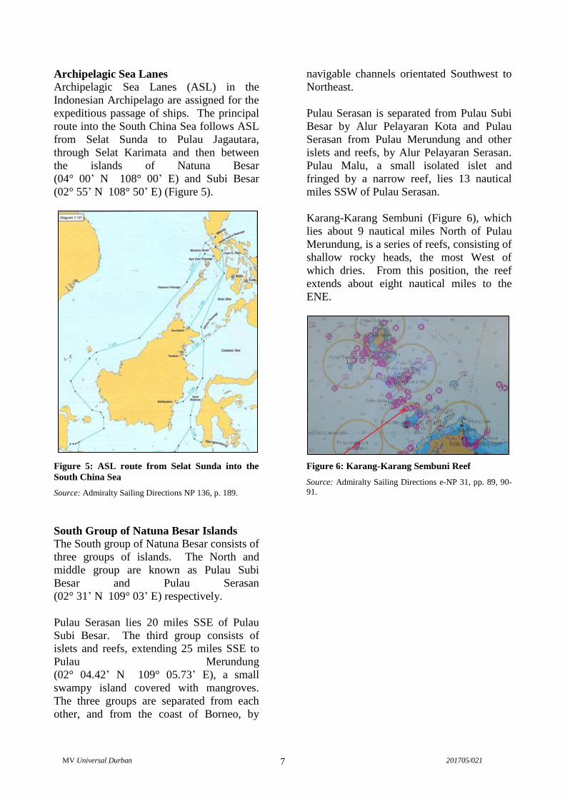
Archipelagic Sea Lanes
Archipelagic Sea Lanes (ASL) in the
Indonesian Archipelago are assigned for the
expeditious passage of ships. The principal
route into the South China Sea follows ASL
from Selat Sunda to Pulau Jagautara,
through Selat Karimata and then between
the islands of Natuna Besar
(04° 00’ N 108° 00’ E) and Subi Besar
(02° 55’ N 108° 50’ E) (Figure 5).
Figure 5: ASL route from Selat Sunda into the
South China Sea
Source: Admiralty Sailing Directions NP 136, p. 189.
South Group of Natuna Besar Islands
The South group of Natuna Besar consists of
three groups of islands. The North and
middle group are known as Pulau Subi
Besar and Pulau Serasan
(02° 31’ N 109° 03’ E) respectively.
Pulau Serasan lies 20 miles SSE of Pulau
Subi Besar. The third group consists of
islets and reefs, extending 25 miles SSE to
Pulau Merundung
(02° 04.42’ N 109° 05.73’ E), a small
swampy island covered with mangroves.
The three groups are separated from each
other, and from the coast of Borneo, by
navigable channels orientated Southwest to
Northeast.
Pulau Serasan is separated from Pulau Subi
Besar by Alur Pelayaran Kota and Pulau
Serasan from Pulau Merundung and other
islets and reefs, by Alur Pelayaran Serasan.
Pulau Malu, a small isolated islet and
fringed by a narrow reef, lies 13 nautical
miles SSW of Pulau Serasan.
Karang-Karang Sembuni (Figure 6), which
lies about 9 nautical miles North of Pulau
Merundung, is a series of reefs, consisting of
shallow rocky heads, the most West of
which dries. From this position, the reef
extends about eight nautical miles to the
ENE.
Figure 6: Karang-Karang Sembuni Reef
Source: Admiralty Sailing Directions e-NP 31, pp. 89, 90-
91.

MV Universal Durban 201705/021 8
ANALYSIS
Aim
The purpose of a marine safety investigation
is to determine the circumstances and safety
factors of the accident as a basis for making
recommendations, and to prevent further
marine casualties or incidents from
occurring in the future.
Voyage planning
Section A-VIII/2 of the STCW Convention
addresses voyage planning. It is submitted
that:
‘Prior to each voyage the master of every ship
shall ensure that the intended route from the
port of departure to the first port of call is
planned using adequate and appropriate charts
and other nautical publications as necessary for
the intended voyage, containing accurate,
complete and up-to-date information regarding
those navigational limitations and hazards
which are of a permanent or predictable nature
and which are relevant to the safe navigation of
the ship.’
Universal Durban’s guidelines on voyage
planning stated that an appraisal of all
information relevant to the voyage should be
considered including appropriate scale
charts, sailing directions, list of lights and
radio aids to navigation, tide tables and
current atlas, hydrographical and
metrological information. Moreover, it was
necessary for the master to approve the
passage plan and related details.
The progress of the vessel had to be closely
and continuously monitored in accordance
with the passage plan. If conditions during
passage posed unacceptable navigational
hazard, the master was required to consider
whether that section of the passage should
be executed or changes made to the plan to
ensure that it remained consistent with the
guidelines.
Appraisal of the voyage plan
A prima facia, evidence submitted to the
MSIU suggested ineffectual appraisal of the
voyage plan. There was no indication of
sailing directions being referred to or chart
permits sent by the chart supplier checked
before uploading to ECDIS10
. Moreover,
the MSIU believes that since the ECDIS
auto scan route check triggered no safety
alarm, the visual route check by the second
mate was only cursory and eventually, the
route North of Pulau Merundung through
Alur Pelayaran Serasan (Figure 7) was
approved by the master.
Figure 7: ECDIS image showing planned route,
North of Pulau Merundung
10
During the course of the Consultation Period, the
Company advised that the master used eNP31 to
plan the voyage.

MV Universal Durban 201705/021 9
Events preceding the grounding
Key navigational information captured by
radar in the VDR11
, is tabulated in table 2.
Table 2: Navigational information
Local Time
hh mm ss
DGPS/WGS84
Lat
Long
Hdg
°
COG
°
SOG
Kts
10 30 00 02° 00.00ʹ N
108° 57.90ʹ E
029 027.5 11.6
11 00 00 02° 05.35.00ʹ N
109° 00.43ʹ E
024.5 023 11.6
11 30 00 02° 10.34ʹ N
109° 03.60ʹ E
020 018.5 11.8
11 45 00 02° 13.00ʹ N
109° 04.52ʹ E
023 021.6 11.7
11 50 00 02° 13.68ʹ N
109° 04.82ʹ E
022.6 021.6 11.8
11 53 00 02° 14.24ʹ N
109° 05.02ʹ E
019.8 018.7 11.9
11 55 00 02° 14.52ʹ N
109° 05.12ʹ E
018.4 023 11.9
11 56 00 02° 14.65ʹ N
109° 05.17ʹ E
006 020 2.6
The safety investigation noticed that as
Universal Durban approached the waypoint
off Karang-Karang Sembuni in Alur
Pelayaran Serasan, the ECDIS was
displaying chart data from a small-scale
chart - ENC EA200003.
The master noted positional inconsistency of
charted objects on display and changed
course outside of the port XTD limit to give
symbol a wider berth.
He felt that the adjusted course was safe to
advance through Alur Pelayaran Serasan.
His leaving the bridge, however, severely
impacted visual situational awareness. The
OOW coming close to finishing his watch
and preparing to hand-over to the relieving
11
The Company reported that ECDIS was not interphased
with the VDR.
officer, was unaware of the approaching
hazard both visually and on the radar
(Figure 8).

MV Universal Durban 201705/021 10
Post-grounding assessment
A post-grounding assessment of events on
board indicated that ENC ID300428
(compilation scale 1:180,000), was not
displayed on ECDIS, although the master
was convinced that an order file containing
ENC ID300428, had been generated and
sent to the chart supplier.
The master explained that since no warning
had been triggered by the Chartplanner
software, he had no reason to suspect that
ENC ID300428 had been inadvertently
deleted prior to placing an order for chart
permits.
Within two hours of the grounding, the
missing digital chart (ID300428) was
ordered and installed on ECDIS. The two
charts-ENC ID300428 and ENC EA200003-
were closely examined. Observations and
positional discrepancies with respect to
Karang-Karang Sembumi were noticed as
follows:
ENC ID300428 -
date of edition 2 – 25.11.2015;
last update 15.05.2017;
compilation scale 1: 180,000;
navigational purpose band 3/coastal;
chart accuracy CATZOC C12
;
horizontal datum: WGS 84; and
12 Positional and depth accuracy of +/- 500 m and 2 m +
5% depths respectively.
Figure 8: Shallow rocky head detected by X-band radar

MV Universal Durban 201705/021 11
cautionary note on chart accuracy:
Owing to the age and quality of the source
information, some detail may not be
positioned accurately. Particular caution is
advised when navigating in the vicinity of
dangers, even when using an electronic
positioning system such as GPS.
ENC EA200003 -
date of edition 2 - 30.09.2008;
last update 17.01.2017;
compilation scale 1: 700,000;
navigational purpose band 2/general;
horizontal datum: WGS 84
chart accuracy CATZOC A113
;
cautionary note on chart accuracy:
None.
13
Positional and depth accuracy of +/- 5 m and 0.5 m +
1% depth respectively.
Moreover, it was apparent that the original
course drawn on ENC ID300428 was unsafe
and the stranded position in Figure 9 (ENC
ID300428) appeared very close to the West
most extremity of Karang-Karang Sembumi.
The safety investigation considered this as a
compelling indication of a positional
anomaly on ENC EA200003.
Categorisation of charted data
Hydrographic survey data used in paper
charts is printed under the chart title and/or
in a source diagram, showing name of
surveying authority, method, date and scale
of survey.
In digital charts, however, survey data is
encoded within a composite data quality
indicator referred to as category of zone of
confidence (CATZOC). The categorisation
relates to the accuracy of the digital chart,
determined by position, depth accuracy, and
seafloor coverage.
Figure 9: ECDIS image showing ENC EA200003 and ENC ID300428 at scale 1:200,000

MV Universal Durban 201705/021 12
CATZOC is a mandatory attribute of S-57
format ENC and is populated by ENC-
producing IHO member states. There are
six levels of CATZOC, ranging from the
most accurate A1 to U – unassessed. By
reference to the CATZOC layer, an ECDIS
menu option, information on quality of data
is displayed.
A distinctive symbol also appears on the
chart. The number of asterisks in the
symbol acknowledges quality of data
(Figure 10). This key information gives
mariners an estimate of the reliability of
charted data when planning or conducting
navigation.
Figure 10: ECDIS image showing quality of data and COTZAC symbol on ENC EA200003

MV Universal Durban 201705/021 13
In this instance, however, cursor query of
(underwater/awash rock) in Figure 11 shows
the position marked at
02° 15.053’ N 109° 07.114’ E. The fact
that Universal Durban stranded in position
02° 14.65’ N 109° 05.17’ E, where water
depths are indicated to be in the region of
30 m are given on ENC EA200003,
suggested that the area North of Pulau
Merundung was not comprehensively
surveyed14
and that generic isolated danger
exceed the tolerance defined by the
CATZOC.
14
The minor damage to the bottom shell plating reported
by Class suggested Universal Durban struck a
relatively soft seabed.
It was evident that the quality of data
encoded within the composite data quality
did not correspond with the value shown on
the chart. Indeed, data quality attribute
CATZOC A1 gave a misleading impression
of accuracy.
During the safety investigation of Universal
Durban, the MSIU was informed that ENC
EA200003 was temporarily withdrawn due
to the numerous and pending updates.
A table of CATZOC from The Mariner’s
Handbook, Eighth Edition, 2004 is
reproduced in Table 3.
Figure 11: ECDIS image showing position and textual information of on ENC EA200003

MV Universal Durban 201705/021 14
Table 3: Category of Zones of Confidence
ZOC Position
Accuracy
Depth
Accuracy Seafloor Coverage
A1 ± 5 m
= 0.50 + 1%
depth Full seafloor
coverage. All
significant features
detected and depths
measured.
Depth
(m)
accuracy
(m)
10
30
100
1000
± 0.6
± 0.8
± 1.5
± 10.5
A2 ± 20 m
= 1.00 + 2%
depth Full seafloor
coverage. All
significant features
detected and depths
measured.
Depth
(m)
accuracy
(m)
10
30
100
1000
± 1.2
± 1.6
± 3.0
± 21.0
B ± 50 m
= 1.00 + 2%
depth Full seafloor
coverage not
achieved; uncharted
features, hazardous
to surface
navigation are not
expected but may
exist.
Depth
(m)
accuracy
(m)
10
30
100
1000
± 1.2
± 1.6
± 3.0
± 21.0
C ± 500 m
= 2.00 + 5%
depth Full seafloor
coverage not
achieved, depth
anomalies may be
expected.
Depth
(m)
accuracy
(m)
10
30
100
1000
± 2.5
± 3.5
± 7.0
± 52.0
D Worse than ZOC C. Full seafloor coverage not
achieved, large depth anomalies may be
expected
U Unassessed
CONCLUSIONS
1. ENC ID300428 was inadvertently
deleted while preparing an Order File
on Chartplanner;
2. No warning of the deletion had been
triggered;
3. A small scale chart, designated
‘general’ in the navigational purpose
band, was displayed on ECDIS;
4. The passage plan prepared by the
navigational officer deviated from the
designated ASL for the Indonesian
Archipelago;
5. There was no evidence of reference to
the Admiralty Sailing Directions prior
to laying courses in Alur Pelayaran
Serasan;
6. ECDIS auto-scan route check triggered
no navigational warning within the
safety zone defined by the XTD and
safe water depth/contour settings;
7. Visual route check by the OOW was
cursory and the master did not cross-
check the passage on ECDIS;
8. Digital chart permits received from
Datema were not checked before
uploaded to ECDIS;
9. Significant positional and depth
anomalies were noticed on ENC
EA200003 in an area North of Pulau
Merundung.
SAFETY ACTIONS TAKEN DURING
THE COURSE OF THE SAFETY
INVESTIGATION15
In order to prevent a recurrence of the
accident, the Company has changed the
ECDIS chart licenses with the chart supplier.
The Company has now opted for a pay-as-
you-go licence which will now ensure that all
15
Safety actions and recommendations shall not
create a presumption of blame and / or liability.

MV Universal Durban 201705/021 15
charts are on board and no charts are ‘lost’
during the ordering process.
Datema Delfzijl B. V. has confirmed that
with the development of the new version of
its Chartplanner software, the findings of the
safety investigation report will be taken into
consideration a decision will be taken as to
whether a forewarning needs to be built in
the software.
RECOMMENDATIONS
The East Asia Hydrographic Commission is
recommended to:
10/2018_R1 Review the ENC production
process in order to ensure that CATZOCs
are populated with meaningful values,
commensurate with quality of data survey.

MV Universal Durban 201705/021 16
SHIP PARTICULARS
Vessel Name: Universal Durban
Flag: Malta
Classification Society: China Classification Society
IMO Number: 9644251
Type: Bulk carrier
Registered Owner: Beheermatschappij Universal Durban
Managers: Universal Shipping B. V., The Netherlands
Construction: Steel
Length Overall: 159.60 m
Registered Length: 149.95 m
Gross Tonnage: 15732
Minimum Safe Manning: 14
Authorised Cargo: Dry Bulk
VOYAGE PARTICULARS
Port of Departure: Bell Bay, Tasmania
Port of Arrival: Bintulu, Malaysia
Type of Voyage: International
Cargo Information: 21,772 mt of Manganese Sinter
Manning: 16
MARINE OCCURRENCE INFORMATION
Date and Time: 13 may 2017 at 11:56 (LT)
Classification of Occurrence: Serious Marine Casualty
Location of Occurrence: 02° 14.65’ N 109° 05.17’ E
Place on Board Ship/other
Injuries / Fatalities: None
Damage / Environmental Impact: None
Ship Operation: In passage
Voyage Segment: Transit
External & Internal Environment: Sea: smooth, no swell. Wind: Southerly 7 to 10
knots. Visibility: 6 miles. Air and sea temperature:
29 °C and 27 °C respectively.
Persons on board: 16


![Home [mtip.gov.mt]](https://img.pdfslide.net/doc/110x75/615c250bc99c413a23536036/home-mtipgovmt.jpg)