Embed Size (px)
Citation preview

i
Saltfleet to Gibraltar Point
Strategy M a y 2 0 1 9
Coastal frontage between Trusthorpe and Sutton on Sea

ii

1
Saltfleet to Gibraltar Point Strategy
Document history and status
Version Status Signed off by: Date signed Date issued
1.0 Issued as the Strategy
plan
Jacobs/MC August 2018 23 August 2018
2.0 Change to strategy
document format
Jacobs/MC March 2019 14 March 2019
2.1 Draft strategy for
consultation following
client comments
Jacobs/MC May 2019 17 May 2019

2
Saltfleet to Gibraltar Point Strategy
Contents
Section Page
Introduction ................................................................................................................................... 1
Purpose of this document ................................................................................................... 1
Strategic framework ........................................................................................................... 2
Policy framework ................................................................................................................ 5
Social and political background .......................................................................................... 6
Environmental designations ............................................................................................... 7
Strategy objectives .............................................................................................................. 7
Background to the present situation ........................................................................................ 9
Flood risk ............................................................................................................................. 9
Flood risk management .................................................................................................... 12
Flood response planning as part of managing flood risk .................................................. 15
Going forward ....................................................................................................................... 17
The need to do something ................................................................................................ 17
Strategic option appraisal ................................................................................................. 18
3.2.1 Flood damages ..................................................................................................... 18
3.2.2 Benefits (damages avoided) ................................................................................ 21
3.2.3 Description of approaches ................................................................................... 21
3.2.4 Option costs ......................................................................................................... 24
3.2.5 Benefit-cost assessment ...................................................................................... 25
Strategy approaches and engagement ............................................................................. 26
3.3.1 Stakeholder workshops ....................................................................................... 27
3.3.2 Public consultation .............................................................................................. 29
Environmental assessment ............................................................................................... 29
Carbon considerations ...................................................................................................... 31
Option appraisal summary ................................................................................................ 32
The proposed strategy ........................................................................................................... 33
Preferred strategy ............................................................................................................. 33
Delivery ............................................................................................................................. 35
4.2.1 Stage 1 (years 1 to 5) ........................................................................................... 36
4.2.2 Stage 2 (years 6 to 10) ......................................................................................... 37
4.2.3 Stage 3 (the next 10 to 25 years) ......................................................................... 37
Long-term management ................................................................................................... 38
Implementation plan ............................................................................................................. 40
Overview ........................................................................................................................... 40
Stage 1 activities (2021 to 2026) ....................................................................................... 41
Stage 2 activities (2026 to 2031) ....................................................................................... 42
Stage 3 activities (2031 to 2060) ....................................................................................... 43

3
Long-term activities .......................................................................................................... 43
Next steps ......................................................................................................................... 43
Glossary, acronyms and abbreviations ............................................................................................... 44


SALTFLEET TO GIBRALTAR POINT STRATEGY – DRAFT STRATEGY FOR CONSULTATION
1
Introduction
Purpose of this document This document presents the proposed strategy for the next 100 years of flood risk
management of the coastline from Saltfleet Haven in the north to Gibraltar Point to the south
(refer to Figure 11). It has been produced for the benefit of people and the developed
environment, taking account of any potential to impact upon the natural environment,
historic (built) environment, potential long-term affordability and sustainability.
The Lincolnshire coastal flood plain has had a long history of flooding from the sea and many
forms of defence are now in place including sand dunes, seawalls, rock/timber structures and
beaches. The coastline between Mablethorpe and Skegness has benefited from beach
nourishment, the present flood risk management approach, since 1994. Continuing with that
approach, or considering alternative ways to manage this shoreline, have now been reviewed
to take account of the latest information, knowledge, understanding, and people’s
aspirations.
Our strategy has been reviewed in line with government requirements and has been
developed in part through formal consultation with statutory bodies. We have completed a
1 Map reproduced from Ordnance Survey material, © Crown copyright, Environment Agency license 100024198.
Figure 1: Location plan with strategy area outlined

SALTFLEET TO GIBRALTAR POINT STRATEGY – DRAFT STRATEGY FOR CONSULTATION
2
series of statutory stakeholder engagement workshops and public consultation events
involving business, tourism and community representatives as well as members of the general
public. This has provided a wealth of local views and preferences to be collated and
considered to help determine the preferred approach to future management. We will
continue our conversations with partners, statutory stakeholders and local communities as
the works arising from the strategy are developed in detail. Formal consents, including
planning permission supported by Environmental Statements, will be required which will
provide further opportunities for public comment.
Any future strategy will require a high level of central government funding or Grant in Aid,
and whilst this strategy will manage the risk of flooding from the sea, it is essential that
government funding is also available to manage the risk from weather events inland. The
consultation process has included a benefit allocation process for all coastal and inland
projects by other flood risk management authorities (internal drainage boards and local
authorities) which are required to protect the area. This is because there is little value in
maintaining coastal defences without inland drainage systems and outfalls, and vice versa. As
such any funding is sourced from a risk to inland flooding and separately for coastal flooding.
A benefit apportionment process has been prepared by which benefits can be apportioned
between the coastal flood risk and the fluvial/surface water flood risks. The following
references, principals and guidance, provide a framework for the apportionment of benefits
for the Saltfleet to Gibraltar Point Strategy and inland programmes of projects over the period
2021 to 2121.
1. Flood and Coastal Resilience Partnership Funding, Defra policy statement on an outcome-focused, partnership approach to funding 23 May 2011.
2. Principles for implementing flood and coastal resilience funding partnerships – DEFRA / Environment Agency 2012.
3. Calculate Grant in Aid funding for flood and coastal erosion risk management projects, Feb 2014. Guidance for risk management authorities - Environment Agency.
Strategic framework Coastal strategies form the second tier in the shoreline management process planning
hierarchy, sitting below the high level non-statutory Shoreline Management Plans and above
the local level scheme design and implementation stages.
This document sets out the future direction for the
management of flood risk to the Lincolnshire coastal flood plain
between Saltfleet Haven and Gibraltar Point.

SALTFLEET TO GIBRALTAR POINT STRATEGY – DRAFT STRATEGY FOR CONSULTATION
3
Tier Structure SMP to Strategy to Scheme Flow Chart
The Flamborough Head to Gibraltar Point Shoreline Management Plan (SMP2 - HECAG 2010)2
sets out the overarching direction for managing coastal flood risk across the area. The short,
medium, and long-term management policies for the strategy area are shown below3.
2 Refer to: https://www.nelincs.gov.uk/planning-and-development/planning-policy/the-local-plan/the-new-local-plan/pre-
submission-draft-local-plan/humber-estuary-coastal-authorities-group-flamborough-head-gibraltar-shoreline-
management-plan-2010/.
3 Policies include increasing activity level to sustain the existing level of flood risk into the future, compensating for future
changes (such as climate change sea level rise and increased storminess).
Shoreline Management Plan (SMP) Units and Policies
Unit N: South of
Humberston Fitties to
Theddlethorpe
Unit O: Theddlethorpe
St Helen to Skegness south
Unit P: Skegness south
to Gibraltar Point
Short term
(Present - 2025) Hold the line Hold the line Hold the line
Medium term
(2025 - 2055) Hold the line Hold the line Hold the line
Long term
(2055 - 2105) Hold the line
Hold the Line /
limited Managed
Realignment
considered where
appropriate
Hold the line /
limited
Managed
Realignment

SALTFLEET TO GIBRALTAR POINT STRATEGY – DRAFT STRATEGY FOR CONSULTATION
4
The policies for the long term are conditional. They depend on the results of monitoring and
research into climate change, shoreline response and the role of the defences. This strategy
forms the next step in establishing the future management approach of this shoreline by
identifying how those medium and longer-term policies may be provided. It particularly sets
out approaches for works and other management activities required over the first ten years
that are consistent with that direction, and sufficiently flexible and adaptable to not be
detrimental to any long-term aspirations.
The Saltfleet to Gibraltar Point Strategy Study Area (National Grid references TF467934 to
TF567569) is divided into 3 zones based on the level of historic intervention along the coast.
These are closely related to the SMP policy units (refer to Figure 2).
Figure 2: Strategy area
Zone A - Northern area
Saltfleet to Theddlethorpe (Meers Bank)
(SMP Policy Unit N: South of Humberston Fitties to Theddlethorpe St Helen)
Zone B - Central area
Mablethorpe (Meers Bank) to Skegness (Lifeboat Avenue) (SMP Policy Unit O: Viking Gas
Terminal (Theddlethorpe St Helen) to Skegness south)

SALTFLEET TO GIBRALTAR POINT STRATEGY – DRAFT STRATEGY FOR CONSULTATION
5
Zone C - Southern area
Skegness (Lifeboat Avenue) to Gibraltar Point
(SMP Policy Unit P: Skegness south to Gibraltar Point)
It should be noted that the present flood risk management approach has been concentrated
in Zone B, between Mablethorpe and Ingoldmells, with only one intervention in 1995 just
north of Skegness. The beaches within Zone B are far narrower than in Zones A and C as well
as being subject to a much greater erosion under the natural processes of waves and tides.
As such Zone B is the focal point for the majority of the nourishment to date. In addition to
the natural erosion, Zone B is also fronting the most economically valuable areas, in terms of
population density, housing and businesses. North of Mablethorpe and south of Skegness
(Zones A and C respectively) the movement of sand by natural processes (waves and currents)
has resulted in accretional trends with wider stable beaches in front of sand dunes. Little if
any active intervention has therefore been necessary along those lengths.
Policy framework With Lincolnshire being a two-tier county, the territory is administered by Lincolnshire County
Council (LCC) and East Lindsey District Council (ELDC). The National Planning Policy
Framework (NPPF) (Department for Communities and Local Government 2018, now called
the Ministry of Housing, Communities and Local Government) sets out the government’s
planning policies; of particular relevance to the strategy are policies relating to the historic
environment, biodiversity and geological conservation, and climate change and flood risk.
The East Inshore and East Offshore Marine Plan (UK Government, 2014), provides guidance
for sustainable development from Flamborough Head to Felixstowe.
East Lindsey’s Local Plan (ELDC, adopted July 2018) comprises the Draft Core Strategy and
Settlement Proposals. The former document contains Strategic Policy 13 on ‘Coastal East
Lindsey’, which sets out “here ELDC wants to be” in terms of a strong, diverse and growing
economy and business sector and “What it will look like” in terms of a vibrant place where
people want to live, invest, visit and work4. East Lindsey District Council has also produced a
strategic flood risk assessment to inform the Council’s strategy for delivering sustainable
development5.
Flood risk management and other relevant plans
The strategy area is covered by a number of Risk Management Authorities, including the
Environment Agency, Lindsey Marsh Internal Drainage Board, LCC and ELDC. The area’s River
Basin Flood Risk Management Plans include the Humber River Basin6 and the Anglian River
4 Refer to: https://www.e-lindsey.gov.uk/article/5116/Emerging-Local-Plan.
5 Refer to: https://www.e-lindsey.gov.uk/article/6200/Strategic-Flood-Risk-Assessment.
6 Refer to: https://www.gov.uk/government/publications/humber-river-basin-district-flood-risk-management-plan.
SALTFLEET TO GIBRALTAR POINT STRATEGY – DRAFT STRATEGY FOR CONSULTATION
6
Basin7. The Environment Agency is consulting on the draft National flood and coastal erosion
risk management strategy for England8. This sets out the strategic aims, roles and
responsibilities and funding arrangements for flood and coastal risk management. The
consultation runs from 9 May 2019 to 4 July 2019.
The Greater Lincolnshire Local Enterprise Partnership’s (GLLEP)9 emerging Greater
Lincolnshire Coastal Vision is drawing together strategies and plans (including this strategy)
that set out significant aspirations for the future of Coastal Greater Lincolnshire into a
coherent whole. While focusing on its ambitions for the coast's contribution to Greater
Lincolnshire's economic growth, GLLEP’s vision is that by 2035 coastal communities and
businesses will be good opportunities for investment because of secure water supply and
flood risk management, a planning policy that supports appropriate growth and the
environment, and a thriving visitor economy that benefits local communities and visitors
alike.
This includes a Wild Coast Vision for the Lincolnshire coast seeks to deliver a sustainable
natural coastal environment providing high quality facilities for communities and visitors,
improvements for wildlife and contributing to a healthy local economy.
The UK 25 Year Environment Plan (Defra, 2018)10 identifies goals and targets to improve the
UK environment and achieve: clean air; clean and plentiful water; thriving plants and wildlife;
reductions in the risks of harm from environmental hazards; sustainable and efficient use of
natural resources; enhancement of the beauty, heritage and engagement with the natural
environment; minimisation of waste; mitigation and adaptation to climate change;
enhancement of biosecurity and the management of exposure to chemicals.
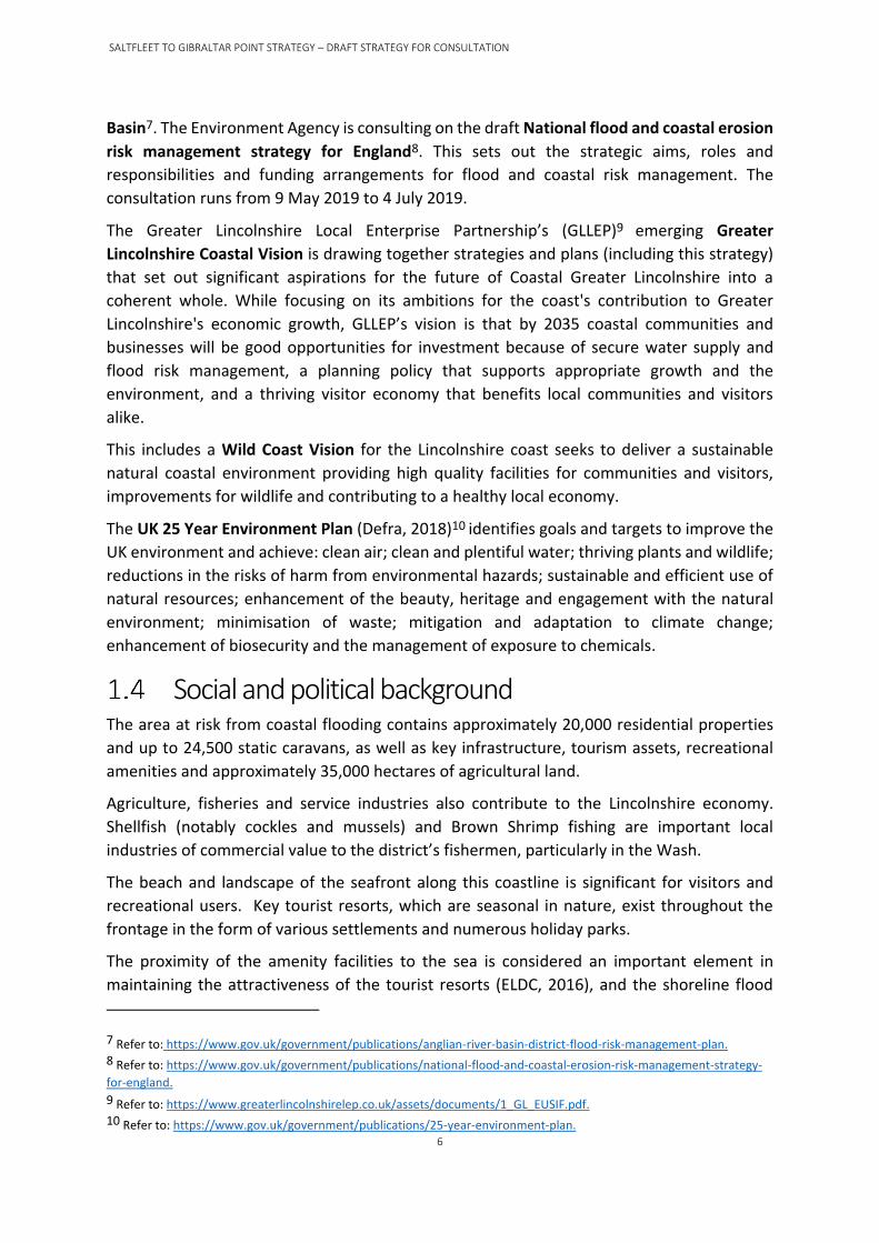
Social and political background The area at risk from coastal flooding contains approximately 20,000 residential properties
and up to 24,500 static caravans, as well as key infrastructure, tourism assets, recreational
amenities and approximately 35,000 hectares of agricultural land.
Agriculture, fisheries and service industries also contribute to the Lincolnshire economy.
Shellfish (notably cockles and mussels) and Brown Shrimp fishing are important local
industries of commercial value to the district’s fishermen, particularly in the Wash.
The beach and landscape of the seafront along this coastline is significant for visitors and
recreational users. Key tourist resorts, which are seasonal in nature, exist throughout the
frontage in the form of various settlements and numerous holiday parks.
The proximity of the amenity facilities to the sea is considered an important element in
maintaining the attractiveness of the tourist resorts (ELDC, 2016), and the shoreline flood
7 Refer to: https://www.gov.uk/government/publications/anglian-river-basin-district-flood-risk-management-plan. 8 Refer to: https://www.gov.uk/government/publications/national-flood-and-coastal-erosion-risk-management-strategy-
for-england.
9 Refer to: https://www.greaterlincolnshirelep.co.uk/assets/documents/1_GL_EUSIF.pdf. 10 Refer to: https://www.gov.uk/government/publications/25-year-environment-plan.
SALTFLEET TO GIBRALTAR POINT STRATEGY – DRAFT STRATEGY FOR CONSULTATION
7
defences themselves currently provide a recreational amenity along the promenades. The
presence of a beach is a key feature for the traditional tourism that is currently offered within
the busier tourist resorts, and its loss could therefore have significant impacts on the tourist
industry in some areas.
Environmental designations Internationally designated European environmental sites lie to the north of Mablethorpe and
to the south of Skegness. Of note these include the Saltfleet-by-Theddlethorpe Dunes &
Gibraltar Point Special Area of Conservation (SAC), Gibraltar Point Special Protection Area
(SPA)/Ramsar, The Wash SPA/Ramsar & The Wash and North Norfolk SAC. In addition, there
are nationally and locally designated sites [Sites of Special Scientific Interest (SSSIs), National
Nature Reserves (NNRs), and Sites of Nature Conservation Importance (SNCIs)] and the coast
was recently designated as a Heritage Coast and habitats of principal importance.
Within the Strategy area, water bodies include coastal transitional and transitional waters,
rivers and groundwater, as defined under the Water Framework Directive11 (WFD). Numerous
drainage channels and managed watercourses outfall to the North Sea. The Strategic
Environmental Assessment Environmental (SEA) Report12 which accompanies this strategy
describes in detail the environment and designations with reference to the relevant
regulations and directives.
Strategy objectives The following objectives have been set for the strategy:
• Implement the policies to Hold the Line set out in the Shoreline Management Plan
covering the Lincolnshire coast from Saltfleet to Gibraltar Point and to inform the
Local Flood Risk Management Strategy.
• Support relevant planning policies to ensure a balance between flood risk
management, land use planning and the needs of a viable and sustainable local
community and economy.
• Sustain the present standard of protection for the duration of the strategy taking
account of climate change.
• Monitor and review to deliver efficient and effective implementation.
• Meet the objectives of the UK 25 Year Environmental Plan (Defra, 2018) including
carbon neutral solutions, working with others, growth, etc..
11 European Community Directive (2000/60/EC) on integrated river basin management. The WFD sets out environmental
objectives for water status and is available as an appendix to the Saltfleet to Gibraltar Point Strategic Environmental
Assessment (SEA) Environmental Report, available as part of this consultation pack.
12 The Environmental Report (ER) which presents the findings of the Saltfleet to Gibraltar Point SEA.

SALTFLEET TO GIBRALTAR POINT STRATEGY – DRAFT STRATEGY FOR CONSULTATION
8
• Identify and implement measures to maximise affordable opportunities to conserve
and enhance biodiversity onshore and offshore in areas affected by flood risk
management.
• Through the Strategy establish an agreed partnership way of working which supports
a sustainable approach to any local contributions coming forward for coastal
management investment into Lincolnshire.

SALTFLEET TO GIBRALTAR POINT STRATEGY – DRAFT STRATEGY FOR CONSULTATION
9
Background to the present situation
Flood risk Lincolnshire’s coastal flood plain is flat and low-lying with much of the land lying below mean
high water spring sea level13. The strategy frontage between Saltfleet and Gibraltar Point
covers 38 km of the open coast. Without sea defences floodwater would reach up to 15 km
inland and could extend even further with climate change predictions and sea level rise (refer
to the cross-section schematic and flood risk map, Figures 3 and 4).
Occupation of this area is the result of land reclamation of marshland areas, involving the
construction of embankments and implementation of drainage schemes over hundreds of
years. A notable point in the history of shoreline change was the establishment of the coast
as a tourist destination by the Victorians. This defined the location of the major tourist resorts
(Mablethorpe, Ingoldmells and Skegness) where the position of the shoreline would go on to
become fixed, through the construction of seawalls and promenades in several locations.
There are numerous records of flooding and the resultant destruction of towns and villages
in historical records going back to the 13th century, but the key event affecting the
management of this coastline in modern times was the storm surge of 31 January 1953. The
beaches were stripped of sand, defences were destroyed and breached in several locations
and sand dunes were washed inland. Over 40 people died in Lincolnshire alone as a result of
the flooding.
13 Mean high water springs (MHWS) is the average height of the two highest high waters of spring tides above a known
datum. MHWS for Skegness is currently 3.15 metres above ordnance datum Newlyn (ODN) or 6.90 metres above chart
datum (CD).
Flooding at Mablethorpe in 1953

SALTFLEET TO GIBRALTAR POINT STRATEGY – DRAFT STRATEGY FOR CONSULTATION
10
Today the strategy area’s flood plain contains approximately 20,000 residential properties,
1700 businesses, up to 24,500 static caravans, as well as key infrastructure, tourism assets,
recreational amenities and approximately 35,000 hectares of agricultural land. Tens of
thousands of people live and work in the area. Without actions to manage flood risk these
would all be vulnerable to tidal inundation.
Most recently, the importance of modern-day flood risk management practice was
demonstrated on 5th December 2013 when a storm surge added up to 1.8m to the
astronomical spring tide levels along the Lincolnshire open coast frontage and peak water
levels were up to 0.7m higher than the 1953 event at Immingham. Without the current flood
defences this area would be under water up to a depth of 3m. Similarly, with good defences
in place, the major storm surge event on 13th January 2017 passed without incident.
Without defences, flooding of the extremely low and extensive flood plain would leave the
land uninhabitable and unusable for any of the current activities. Under these circumstances
the area would not simply revert to a ‘natural’ state without unparalleled levels of mitigating
action. Extraordinary investment would be needed to address the significant pollution that
would occur without it, through the removal of a substantial amount of the extensive
development and infrastructure that is now in place across the hinterland.
The composite flood risk map (Figure 4) illustrates the hazards of having no defence along the
Lincolnshire coastline. As illustrated, the extent of land at risk is considerable, and the extent
of area marked in ‘red’ would be rendered uninhabitable. The risk area in ‘orange’ would still
be subject to inundation, to a lesser degree of risk to people and buildings, but would
eventually (after successive inundations) be also rendered uninhabitable. Buildings would
become progressively damaged, affiliated insurance premiums would be subject to large
increases, land and waterways would become polluted and normal activities would cease.
Agricultural practices over large areas would cease to continue due to the frequency of
inundation and general rise in groundwater levels. Therefore a ‘do nothing’ or undefended
coastline is not a viable option as the losses far exceed the cost of defending the coastline.
Figure 3: Schematic cross-section of the Lincolnshire flood plain without a flood defence
The sea defences prevent high tides from flooding the low lying land
behind. Without seawalls and embankment/dune systems this land would
flood at last 14 days every month.

SALTFLEET TO GIBRALTAR POINT STRATEGY – DRAFT STRATEGY FOR CONSULTATION
11
Without a coastal strategy to protect the area, tidal inundation leaving large areas of the land
behind completely uninhabitable and unusable for any current activities, would occur on a
frequent basis. Furthermore, as sea levels are predicted to rise even further beyond 2100
(reference UKCP18), the area affected will invariably extend inland.
Figure 4: Area at Risk of Flooding (2115) without Sea Defences. Source: ELDC 2017
(Refer to the schematic cross-section)

SALTFLEET TO GIBRALTAR POINT STRATEGY – DRAFT STRATEGY FOR CONSULTATION
12
Flood risk management Sea defences in the form of embankments, seawalls and timber groynes were rebuilt in the
aftermath of 1953 and these have subsequently been improved and refurbished over time.
However, from the 1960s onwards, with more emphasis on monitoring, the foreshore
between Mablethorpe and Skegness was observed to be volatile and vulnerable to sudden
major drops in beach level than previously understood, leaving the seawalls exposed to wave
action and the risk of failure. Although works continued to maintain the existing defence
assets to protect the homes, businesses and local economy, without maintaining the beach
levels there was no consistent, rated defence, against coastal flooding.
Timber groynes, where previously used along Lincolnshire’s coastal flood plain, proved to be
an ineffective method in retaining a stable beach (refer to the adjacent photograph). Unlike
rock groynes, timber groynes are unable to accommodate large changes in beach level and
can generate high current velocities along the leading edge, as well as reflect wave energy.
Most of these timber groynes were removed in the 1990s. Rock groynes, apart from being
In the absence of coastal flood risk management works, 20,000 homes,
1,700 businesses, 24,500 static caravans, key infrastructure, tourism
assets, recreational amenities and 35,000 hectares of agricultural land
would be at significant risk from tidal inundation. Loss of life could be
greater than that experienced during the 1953 floods.
The predicted frequency of inundation would most likely render areas
uninhabitable and unsafe for any of their current uses.
Timber groynes and clay foreshore exposed before beach nourishment

SALTFLEET TO GIBRALTAR POINT STRATEGY – DRAFT STRATEGY FOR CONSULTATION
13
more durable, will absorb more wave energy, including that reflected from the seawall. By
further dampening the incident wave energy the chances of suspended sediments to deposit
nearshore is increased.
In 1994 a change to flood risk management was introduced. The new management approach
involved major beach nourishment campaigns (informed by beach level monitoring) as a
methodology to sustain beach levels at predetermined design profiles that provide a wide
defence that protect the seawalls. Fundamentally the beaches reduce the potential for
seawalls to be undermined whilst limiting the risk of wave action and overtopping.
Since 2008 the beach nourishment campaigns have required a lesser volume of imported
material to maintain the beach levels. This is largely due to the fact that in the 1990s, upon
inception of the current strategy, the beach levels were much lower than present. As such
larger volumes were required to ‘build’ the existing beaches whereas now we are in a position
where ‘building’ the beach up has developed into ‘maintaining’ the beach levels. A
considerable volume of current imported sand is often concentrated on erosion ‘hotspot’
areas. Figure 5 illustrates how the volumes of nourishment have changed through various
timescales.
The evidence to date from our beach monitoring programme means that our nourishment
work is concentrated within Zone B, the central area between Mablethorpe and Skegness and
Figure 5: Nourishment volumes placed at ‘hotspot’ areas
SALTFLEET TO GIBRALTAR POINT STRATEGY – DRAFT STRATEGY FOR CONSULTATION
14
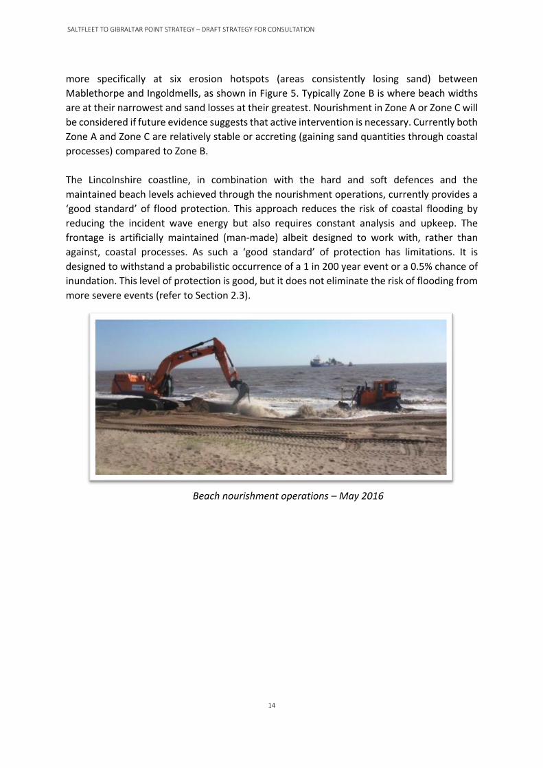
more specifically at six erosion hotspots (areas consistently losing sand) between
Mablethorpe and Ingoldmells, as shown in Figure 5. Typically Zone B is where beach widths
are at their narrowest and sand losses at their greatest. Nourishment in Zone A or Zone C will
be considered if future evidence suggests that active intervention is necessary. Currently both
Zone A and Zone C are relatively stable or accreting (gaining sand quantities through coastal
processes) compared to Zone B.
The Lincolnshire coastline, in combination with the hard and soft defences and the
maintained beach levels achieved through the nourishment operations, currently provides a
‘good standard’ of flood protection. This approach reduces the risk of coastal flooding by
reducing the incident wave energy but also requires constant analysis and upkeep. The
frontage is artificially maintained (man-made) albeit designed to work with, rather than
against, coastal processes. As such a ‘good standard’ of protection has limitations. It is
designed to withstand a probabilistic occurrence of a 1 in 200 year event or a 0.5% chance of
inundation. This level of protection is good, but it does not eliminate the risk of flooding from
more severe events (refer to Section 2.3).
Beach nourishment operations – May 2016
SALTFLEET TO GIBRALTAR POINT STRATEGY – DRAFT STRATEGY FOR CONSULTATION
15
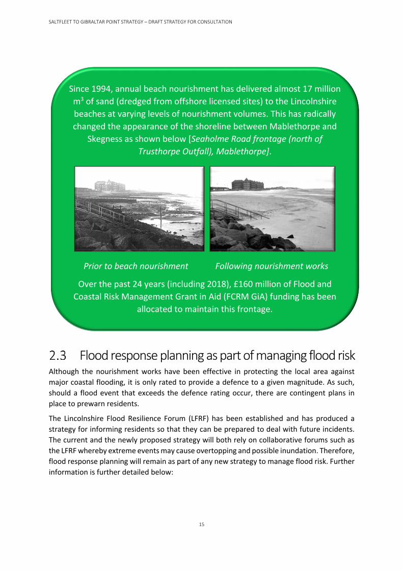
Flood response planning as part of managing flood risk Although the nourishment works have been effective in protecting the local area against
major coastal flooding, it is only rated to provide a defence to a given magnitude. As such,
should a flood event that exceeds the defence rating occur, there are contingent plans in
place to prewarn residents.
The Lincolnshire Flood Resilience Forum (LFRF) has been established and has produced a
strategy for informing residents so that they can be prepared to deal with future incidents.
The current and the newly proposed strategy will both rely on collaborative forums such as
the LFRF whereby extreme events may cause overtopping and possible inundation. Therefore,
flood response planning will remain as part of any new strategy to manage flood risk. Further
information is further detailed below:
Since 1994, annual beach nourishment has delivered almost 17 million
m3 of sand (dredged from offshore licensed sites) to the Lincolnshire
beaches at varying levels of nourishment volumes. This has radically
changed the appearance of the shoreline between Mablethorpe and
Skegness as shown below [Seaholme Road frontage (north of
Trusthorpe Outfall), Mablethorpe].
Prior to beach nourishment Following nourishment works
Over the past 24 years (including 2018), £160 million of Flood and
Coastal Risk Management Grant in Aid (FCRM GiA) funding has been
allocated to maintain this frontage.

SALTFLEET TO GIBRALTAR POINT STRATEGY – DRAFT STRATEGY FOR CONSULTATION
16
The Lincolnshire Local Resilience Forum works very closely with the
Environment Agency and many other professional partners both in
planning to reduce the effects of flooding and in the response to an
incident – see: http://www.lincolnshire.gov.uk/lincolnshire-prepared/
The Environment Agency is responsible for flood warning. Using the
latest technology, staff monitor rainfall, river levels and sea conditions
to forecast the possibility of flooding. If flooding is forecast, warnings
are issued using a set of three easily recognisable codes. These are;
• Flood Alert - means that flooding is possible and that you need
to be prepared.
• Flood Warning - means that flooding is expected and that you
should take immediate action. You should take action when a
flood warning is issued and not wait for a severe flood warning.
• Severe Flood Warning - means that there is severe flooding and
danger to life. These are issued when flooding is posing
significant risk to life or disruption to communities.
More information can be found on the Environment Agency’s website
or by telephoning Floodline on 0345 988 1188.

SALTFLEET TO GIBRALTAR POINT STRATEGY – DRAFT STRATEGY FOR CONSULTATION
17
Going forward
The need to do something Continued management of the coastal frontage is critical for the protection of people and
property, maintaining existing land uses and providing multiple social and environmental
interests.
Without maintaining flood defences through sustaining beach nourishment activities, there
would be areas on the Lincolnshire coast with no sand and considerably lower sand levels
overall. Without beaches the seawalls in Zone B would be exposed to larger waves, with
increasing potential for damage, threatening the structural integrity of the seawall, and
ultimately leading to the failure of the defences. Larger waves and lower beaches will also
result in higher levels of overtopping, which sea level rise will exacerbate, further damaging
the wall and increasing the risk of breach. Ongoing loss of sand will also expose and lead to
erosion of the clay foreshore in places, which would lead to further undermining and collapse
of the seawall.
Previous strategy reviews concluded that maintaining an open beach with regular
nourishment was the most economic, technically feasible and environmentally beneficial
management regime (refer to the option appraisal section below and the SEA Environmental
Report for more detail on environmental assessment). However, further research has
concluded that in the long-term this approach may become increasingly unsustainable due to
the increase in the extent of operations necessary to accommodate expected climate change
effects, e.g. sea level rise, and the higher costs associated with those increases together with
increasing demands on national funding.
Funding has been secured to continue with the current beach nourishment approach until
2020. Any alternative management approach and options must be examined in the interim,
but the coastline will continue to be protected until a route forward is defined.
Furthermore, all the sand used to nourish the Lincolnshire coastline is imported from
designated offshore licensed dredging sites. The cost of imported sand can fluctuate year on
year due to the available areas but also due to demand from any number of nourishment
There is little natural replenishment of sand on Lincolnshire’s beaches -
the beach seen today is largely artificial and a result of nourishment,
only existing in its present state for less than the last quarter of century.
Historical records indicate that natural beaches were probably never
substantial, and prior to Victorian constructions are most likely to have
comprised a low barrier beach or narrow dune at best, hence the
resulting inundations on many previous occasions.

SALTFLEET TO GIBRALTAR POINT STRATEGY – DRAFT STRATEGY FOR CONSULTATION
18
schemes running. This inherently will drive up costs of imported sand and this has acted as a
driver to evaluate the present management approach as well as the alternatives.
Strategic option appraisal To develop this strategy, the current situation with regards to flood risk on this stretch of the
Lincolnshire coast was fully appraised to assess the scale of present and future risk. This
included how the key characteristics of this coastline might be affected by different
management approaches, and the costs and benefits associated with those different
approaches.
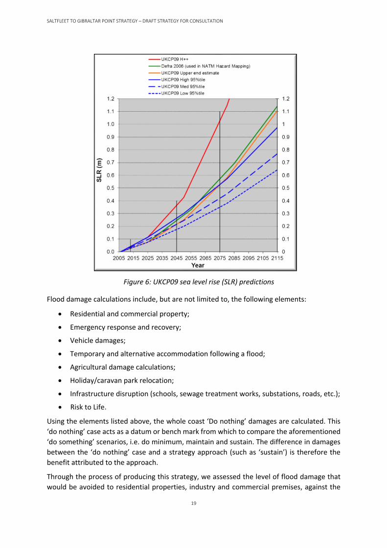
3.2.1 Flood damages To obtain flood damages over 100 years, we chose an estimate of sea level rise (SLR) in
accordance with the UKCP0914 climate change predictions (Figure 6). As shown the two higher
model predictions (excluding the H++ scenario) indicate circa 1 to 1.1m SLR in 100 years’ time
and the upper end estimate was selected for this strategic assessment to provide a
conservative estimate and also for its alignment to the previous Defra 2006 guidance (used in
previous coastal flood modelling studies). It should be noted that although UKCP09 has now
been superseded by UKCP1815, the broader predictions are similar using the scenario that
greenhouse gas emissions will continue to rise throughout the 21st century (RCP8.5). In any
case, future assessments will still be able adjust the damage estimates, adapting to new
climate change predictions as they are developed.
14 Projections of the UK’s future climate, UK Climate Projections 2009 (UKCP09), were launched on June 18th, 2009.
15 New UK Climate Projections 2018 (UKCP18 Marine report, November 2018), www.metoffice.gov.uk.
Global research (e.g. UKCP09/18) has concluded that an increase in
frequency and intensity of weather cycles, in addition to sea level rise, will
occur over the next few decades. Higher sea levels will be a day-to-day
issue and, in combination with larger storm waves, will impact on the sea
defences more often.
The consequences of this will be more volatile beaches, requiring more
sand nourishment, or higher levels of overtopping (resulting in a
requirement for higher and stronger defences) if the beaches are not
maintained. Risk of failure of the defence system will increase
substantially without intervention. Future flood risk management will
need to keep pace with these climate change predictions if the present
standard of protection is to be sustained.
SALTFLEET TO GIBRALTAR POINT STRATEGY – DRAFT STRATEGY FOR CONSULTATION
19
Flood damage calculations include, but are not limited to, the following elements:
• Residential and commercial property;
• Emergency response and recovery;
• Vehicle damages;
• Temporary and alternative accommodation following a flood;
• Agricultural damage calculations;
• Holiday/caravan park relocation;
• Infrastructure disruption (schools, sewage treatment works, substations, roads, etc.);
• Risk to Life.
Using the elements listed above, the whole coast ‘Do nothing’ damages are calculated. This
‘do nothing’ case acts as a datum or bench mark from which to compare the aforementioned
‘do something’ scenarios, i.e. do minimum, maintain and sustain. The difference in damages
between the ‘do nothing’ case and a strategy approach (such as ‘sustain’) is therefore the
benefit attributed to the approach.
Through the process of producing this strategy, we assessed the level of flood damage that
would be avoided to residential properties, industry and commercial premises, against the
Figure 6: UKCP09 sea level rise (SLR) predictions

SALTFLEET TO GIBRALTAR POINT STRATEGY – DRAFT STRATEGY FOR CONSULTATION
20
cost of carrying out works for each option over the strategy period. In economic terms these damages
and costs are assessed in present value16 (PV) terms.
Potential risk management measures include doing nothing, doing minimum and doing
something. They also include maintaining defence levels as they are now, or sustaining
standards of protection by improving them to keep pace with climate change. Alternative
adaptation measures which frequently relate to flood resilience, relocation of people and
property, might in this area also include incorporating flood defence into secondary
structures, e.g. raising highways inland of the sea defences.
Do nothing
The consequences of withdrawing investment in flood risk management on this frontage (a
‘do nothing’ approach) would be extreme and would not fulfil the SMP policy to hold the line.
Sand would disappear from the beaches, exposing the foundations of the seawalls and
ultimately these would fail, thus increasing the severity of inundation from coastal flooding.
However the ‘do nothing’ approach is taken as the economic base case against which all other
options are assessed.
• Our assessment has returned a value of do nothing PV damages of £4,525 million.
Do minimum
Even if minimal works were undertaken to maintain and repair the existing seawalls, this
would only extend the seawalls’ serviceable life for a few more years with a reducing beach
level year on year. Defined as ‘do minimum’, these actions will have limited effectiveness
against future exposure and the standard of protection would reduce; this would result in
increasing numbers of flood warnings and a need to develop safe havens for people.
Ultimately, failure and breach of the walls would still result if ‘minimal’ works were carried
out as the wall would eventually be undermined by the reducing beach levels and likely
collapse, thus failing.
• Our assessment has returned a value of do minimum PV damages of £2,442 million.
Do something (maintain and sustain)
Considering the aforementioned ‘do nothing’ and ‘do minimum’ approaches, the foundation
for the strategy is to ‘do something’ to continue to defend the area and therefore ‘hold the
line’ either by maintaining the current level of protection (excluding climate change) or
sustaining the same standard (allowing for climate change predictions).
• Our assessment has returned a values for maintain PV damages of £1,381 million and
sustain PV damages of £444 million.
There are a considerable number of ways of ‘doing something’ along this coast, although
several of these are comparable in approach with similar economic, social and environmental
16 Present value (PV) is the current worth of a future sum of money at a specific rate of return (the discount rate). The
higher the discount rate, the lower the PV of the future cash flows. For example, the PV of £1,000 in ten years’ time is £709
at a discount rate of 3.5%.

SALTFLEET TO GIBRALTAR POINT STRATEGY – DRAFT STRATEGY FOR CONSULTATION
21
impacts. Therefore, for initial development and assessment of strategic direction, these were
grouped into strategic concepts and approaches, namely:
1) Holding the Line as a single continuous system with beach nourishment [without control
structures (open beach approach) or with control structures (closed beach approach)];
2) Holding the Line as a single continuous system without beach nourishment (i.e. seawalls
only approach); and
3) Dividing up (segmenting) the coast into a series of separate compartments and
addressing the management of each discrete compartment on the basis of local
requirements.
3.2.2 Benefits (damages avoided) The benefits for each of the approaches are the ‘Do nothing’ PV damages (£4,525 million) less
the ‘do something’ PV damages (e.g. £444 million for the sustain approach). This gives a total
PV benefit for the maintain and sustain approaches of £3,144 million and £4,081 million
respectively.
3.2.3 Description of approaches The following sections describe the approaches and options within these in more detail.
Open beach approach
This approach is the current management practice of beach nourishment, taking sand every
year from licensed offshore sites, to replace material lost through natural erosion and storms,
and pumping it onto the beaches. These beaches limit wave exposure at the seawall and
reduces the risk of damage to its foundations and the supporting clay layer underneath.
Image of beach nourishment along Lincolnshire Coastline
Continuing this practice is a technically viable option, although the nourishment campaigns
will need to become much larger to keep pace with climate change, requiring approximately
double the amount of sand in 50 to 100 years’ time. If we were to continue beach
nourishment with present quantities and frequency, the standard of protection will reduce in
SALTFLEET TO GIBRALTAR POINT STRATEGY – DRAFT STRATEGY FOR CONSULTATION
22
the future. As climate change induced sea level rise occurs, the sand will become more mobile
and the resulting larger waves will be able to reach much further up the beach.
An alternative ‘open beach’ option to address this is nourishing with coarser sand, shingle or
pebbles that cannot be so easily moved around by wind and wave action. This would alter the
profile and character of the beach, and sources for the material are likely to be further away
than the current licensed sites in the area.
In all cases, some works would also be required in the future to maintain and refurbish the
upper sections of the seawalls.
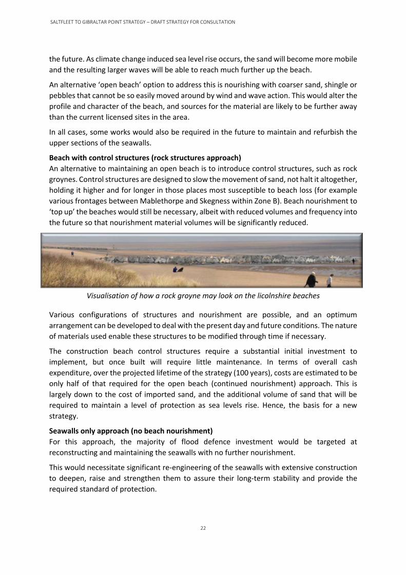
Beach with control structures (rock structures approach)
An alternative to maintaining an open beach is to introduce control structures, such as rock
groynes. Control structures are designed to slow the movement of sand, not halt it altogether,
holding it higher and for longer in those places most susceptible to beach loss (for example
various frontages between Mablethorpe and Skegness within Zone B). Beach nourishment to
‘top up’ the beaches would still be necessary, albeit with reduced volumes and frequency into
the future so that nourishment material volumes will be significantly reduced.
Visualisation of how a rock groyne may look on the licolnshire beaches
Various configurations of structures and nourishment are possible, and an optimum
arrangement can be developed to deal with the present day and future conditions. The nature
of materials used enable these structures to be modified through time if necessary.
The construction beach control structures require a substantial initial investment to
implement, but once built will require little maintenance. In terms of overall cash
expenditure, over the projected lifetime of the strategy (100 years), costs are estimated to be
only half of that required for the open beach (continued nourishment) approach. This is
largely down to the cost of imported sand, and the additional volume of sand that will be
required to maintain a level of protection as sea levels rise. Hence, the basis for a new
strategy.
Seawalls only approach (no beach nourishment)
For this approach, the majority of flood defence investment would be targeted at
reconstructing and maintaining the seawalls with no further nourishment.
This would necessitate significant re-engineering of the seawalls with extensive construction
to deepen, raise and strengthen them to assure their long-term stability and provide the
required standard of protection.

SALTFLEET TO GIBRALTAR POINT STRATEGY – DRAFT STRATEGY FOR CONSULTATION
23
Visualisation of how a typical seawall may look on the Lincolnshire beaches
With no nourishment and the construction of seawalls with a much larger footprint (built
mostly seaward due to the extensive communities and development immediately behind the
current defences), the new seawall would be considerably higher. Indeed it would be a large
monolithic structure, designed to withstand wave attack of increasing magnitude over its
design life. In addition, the sea wall would require scour protection likely in the form of large
rocks along the front toe which would change the function and very look of the beach and the
general Lincolnshire coastal frontage. As such there is expected to be little, if any, beach
remaining, and the foreshore can be expected to return to a pre-1994 state. Sand migration
to the dunes at Gibraltar Point and those north of Mablethorpe would be likely to diminish.
Segment the coast
This approach captures a broad range of possibilities, all with the basic principle that the
whole frontage would be divided up to contain and manage flood risk and enable varying
requirements from social and environmental perspectives. Instead of a blanket standard of
protection throughout, certain areas will be well defended to a higher standard than other
areas. For example, where erosion is most prominent and/or areas most densely populated,
the hinterland would be defended to a higher standard as the risk of loses would be greater.
Flood protection could be provided through a wide range of approaches, including large
beach embayments (created by control structures dampening incident wave energy) allowing
suspended sediments to settle, requiring little and in some cases, no additional nourishment.
A combination of beaches and seawalls and/or new alignments, set back from the present
position, would also be provided. In addition to groynes, the inclusion of larger structures in
certain locations, e.g. erosion hotspots, might further reduce the longer-term nourishment
requirement.

SALTFLEET TO GIBRALTAR POINT STRATEGY – DRAFT STRATEGY FOR CONSULTATION
24
Visualisation of how a fishtail groyne may look on the Lincolnshire beaches
This hybrid approach could provide the opportunity for other parties to make additional
investments that allow more diverse amenity or business interests to be introduced. Although
initial investments in structures would be very high, in the longer-term the requirement and
reliance on beach nourishment could be significantly reduced.
3.2.4 Option costs The costs for all the options have been calculated taking account of some of the variability in
approaches and also considering possible phasing of works. We have added contingencies in
the form of ‘Optimism Bias’ which is based on past experience on this and other projects. For
example, for beach nourishment (the present management option) optimism bias starts by
adding 15% to the base costs from year 6 to year 20, adding 25% from year 21 to year 50 and
adding 40% from year 51.
Many approaches to segmenting the shoreline would intentionally
disrupt and block the movement of sand along the shoreline. Further
beach management is likely to still be required to ensure environmental
and other interests are maintained, in particular north of Mablethorpe
and south of Skegness.
The approach to segmentation cannot therefore be piecemeal - an ‘in-
combination’ vision and approach for the whole area is necessary for
this to deliver a successful long-term strategy throughout.

SALTFLEET TO GIBRALTAR POINT STRATEGY – DRAFT STRATEGY FOR CONSULTATION
25
Figure 7 presents the early high-level assessment of costs illustrating the differences in
expenditure for various approaches in whole life cash and present value (PV) terms. This
confirmed that approaches to hold the present line with beaches as a primary part of the
flood risk management strategy were significantly better in PV economic terms than
alternatives, as well as being better able to deliver on social and environmental requirements.
Amongst all the option costs examined it is notable that the cost of continuing with present
nourishment practice (red line) to provide a similar level of protection to that currently
achieved for the next 100 years, is estimated to be £1,500 million (at today’s prices). The
present value cost (PVc) of same is £339 million. By comparison, the cash cost of providing a
beach with control structures and a reduced nourishment commitment (black line) to provide
the same standard of protection is estimated to be just half of that, in the region of £710
million, with a PVc of £292 million, over 100 years.
Figure 7: 100 year whole life cash costs and PV costs for different strategic approaches
3.2.5 Benefit-cost assessment Examining all the costs and benefits, the highest benefit-cost ratio (BCR), i.e. PV benefits/PV
costs, is to provide a beach with control structures and sand nourishment to ‘sustain’ the
standard of protection (this BCR is 14). The seawall only option has the lowest BCR of 9 and
therefore is the least economic ‘sustain’ option. This further supports the rejection of the

SALTFLEET TO GIBRALTAR POINT STRATEGY – DRAFT STRATEGY FOR CONSULTATION
26
seawall only approach on amenity and landscape grounds (refer to the strategy engagement
section). It should also be noted that the sustain approach is also economically justified on
the incremental benefit-cost ratio (iBCR) test, which is the measure of additional benefits
gained compared to the additional costs expended to achieve a higher standard.
Strategy approaches and engagement
Rather than relying solely on engineered solutions (i.e. structures) to protect people and
property from flooding, the strategy for the future of this frontage takes account of key social,
planning and economic aspirations, e.g. to have a thriving tourism industry associated with
beaches that attract visitors. Agricultural land use is also significant within the strategy area,
whilst fishing (notably cockles, mussels and shrimps) is another important industry of local
commercial value, particularly in The Wash. The preferred strategy therefore seeks to enable
these practices to continue.
Throughout the development of the strategy extensive engagement has been carried out with
statutory organisations, including Natural England and Historic England, Lincolnshire County
Council, East Lindsey District Council, Parish Councils, Environment Agency representatives
and people living and working in the area. Feedback received from stakeholders and the
general public has had a strong influence, in combination with technical appraisals and
environmental assessments, on the development of the strategy and the selection of leading
options and preferred scenarios.
As part of our wider engagement work we have been able to reach out to a large range of
audiences throughout coastal communities in the Strategy area. This has been achieved by
producing strategy newsletters, contributing to both Parish and Town council community
newsletters, extensive coverage in the local media, and attendance at community group
meetings.
The objective of the new strategy is to provide a safe, economic, socially
and environmentally acceptable solution that protects people and the
economy.
The local economy is supported heavily through tourism, although
revenues are also generated from agriculture, fisheries and service
industries. The local authorities will support a strategy that works in
parallel and where possible (combined with additional investment)
encourages economic regeneration and attracts more visitors and
businesses to the area.

SALTFLEET TO GIBRALTAR POINT STRATEGY – DRAFT STRATEGY FOR CONSULTATION
27
3.3.1 Stakeholder workshops A series of workshops were held in 2016 and 2017 with key stakeholders at two key stages of
the strategy development to inform the way forward. These key stages related to the
introduction of high level approaches and then the presentation of six leading options.
To help facilitate the engagement process, technical outline illustrations and visualisations
were prepared to show how the different approaches and their associated options would fit
into the landscape. Although the detailed design of the strategy delivery will follow, along
with further consultation as part of its implementation, the outlines enabled some critical
feedback to be established in the development of a preferred approach.
At each event, specific questions were asked of attendees on each of the approaches or
options presented. For example, at the summer 2017 workshops, stakeholders were asked
to rank the options presented in order of preference and to agree or disagree (ranging from
strongly to neutral) whether an option:
• Is sustainable and technically feasible?
• Manages risk to the health of people and local communities?
• Maintains and enhances the quality and character of the landscape?
• Avoids damage to, and enhances where possible, recreation and tourism?
A summary of some of the feedback from consultation workshops can be seen in the following
table.
Approach Key feedback
Open beach management (similar to present approach)
Positive: Provides a natural looking defence, maintains the current habitat and environment, know it works. Negative: Not likely to be sustainable long-term, costs too much.
Beach with control structures (e.g. rock groynes plus nourishment)
Positive: More permanent long-lasting solution, adds diversity/interest, economic/tourism benefits. Negative: Landscape, public safety, may impact tourism.
Control structures including segmenting the shoreline (e.g. rock fishtails)
Positive: Long-lasting solution, adds diversity/interest, opportunity for additional features, good for tourism. Negative: Bad for landscape, initially expensive, environmental impacts.
As above, with varied standard of protection along frontage
Positive: As above. Negative: Varying protection negative, could be influenced by funding pressures.
Change to coarser beach material
Positive: Good protection, flora/fauna benefits. Negative: Beach amenity, appearance, impact on tourism.
Open beach not sustaining the current standard of protection to keep pace with climate change
Mostly Negative: Feedback from 2016 consultation workshops identified 64% of respondents considered this negatively.
Seawall only without beach nourishment (no beach)
Mostly Negative: Feedback from 2016 consultation workshops was that this would not provide long term security and should not be considered further.

SALTFLEET TO GIBRALTAR POINT STRATEGY – DRAFT STRATEGY FOR CONSULTATION
28
Figures 8 and 9 chart the summary feedback from the 2016 and the 2017 stakeholder events,
regarding the high level approaches and the six leading options (listed below).
Figure 8: Summary feedback from the November 2016 stakeholder
workshops regarding potential approaches
Figure 9: Summary feedback from the summer 2017 stakeholder events
regarding the six leading options
Option
1) Open beach, annual sand nourishment (present management option).
2) Open beach with different beach material grading (coarser sand, shingle or pebbles).
3) Beach nourishment with rock armour groyne structures.
4) Beach nourishment with rock armour structure combinations (groynes and fishtails).
5) Beach nourishment with rock armour structures at lower or higher standards of
protection by changing nourishment volumes.
6) Beach nourishment with rock armour structures at lower or higher standards of
protection by changing nourishment frequency.

SALTFLEET TO GIBRALTAR POINT STRATEGY – DRAFT STRATEGY FOR CONSULTATION
29
3.3.2 Public consultation Formal public consultation (including an e-consultation and six drop-in-sessions around the
strategy area) was held in February-March 2018. These drop-ins were held in Saltfleet, Sutton-
on-Sea, Anderby, Chapel St Leonards, Skegness and Gibraltar Point.
Figure 10 presents a visual summary of the key feedback (option likes and dislikes) received
from the public drop-in sessions. As can be seen the feedback indicates that the open beach
(annual sand nourishment) and the beach nourishment with rock armour structures are the
most favoured options. This feedback is similar to the stakeholder feedback, see to Figure 9.
Figure 10: Summary feedback from the February-March 2018 public drop-in
sessions regarding the six leading options
Environmental assessment A Strategic Environmental Assessment (SEA) was undertaken in parallel with the development
of the draft strategy. The requirement to undertake statutory SEA in the European Union (EU)
came about when the EC Directive (2001/42/EC) ‘on the assessment of the effects of certain
plans and programmes on the environment’, known as the ‘SEA Directive’, came into force in
2004. The overall aim of the SEA Directive is to: “provide a high level of protection to the
environment and to contribute to the integration of environmental considerations into the
preparation and adoption of plans and programmes with a view to promoting sustainable
development.”
The SEA, including the scoping process, has been undertaken to appraise the potential effects
(either beneficial or negative) arising from strategy options, and to ensure that environmental
considerations are considered during the strategy level decision-making process. This
integrated appraisal process has ensured that the potential effects of the various options
considered were identified and, where possible, negative effects could be avoided or
minimised through option selection.

SALTFLEET TO GIBRALTAR POINT STRATEGY – DRAFT STRATEGY FOR CONSULTATION
30
The environmental aspects considered during the development of the strategy are listed in
the following table. The environmental assessment of the strategy proposals is presented in
the SEA Environmental Report (referenced in Section 1.5).
Environmental aspects considered during the development of the strategy
Population, health and economy
• Population and properties at risk – including areas of social deprivation and vulnerable communities
• Importance of the amenity beach
• Tourist facilities, attractions and recreational and amenity resources
• Significant industry, commercial and economic activities – notably agriculture, tourism and commercial fisheries/shellfisheries
• Potential opportunities for economic investment
Material assets • Key transport routes and critical infrastructure – roads, emergency services, power/water infrastructure, windfarm landfalls Long term sustainability and available supply of materials (e.g. sand dredged from offshore)
Wildlife and biodiversity
• Designated nature conservation sites (e.g. Special Areas of Conservation, Special Protection Areas, Sites of Special Scientific Interest, National Nature Reserves)
• Local nature conservation sites (e.g. Local Wildlife Sites)
• Valuable marine, coastal and terrestrial habitats
• Species with legal protection/of conservation concern
• Fish and shellfish Opportunities for habitat improvements
Soils, geology and geomorphology
• Designated earth heritage sites (e.g. Sites of Special Scientific Interest) and local geological sites
• Coastline and marine processes and sediment systems, including downdrift into The Wash Areas of known contaminated land or licensed landfill sites
Land uses Principal land uses at risk – agricultural land
Water Surface water and groundwater resources and quality, including Bathing Waters
Climate • Contribution to, vulnerability and adaptability to climate change
Historic environment
• Coastal heritage of seaside towns and historic townscape/seascape
• Designated heritage assets (e.g. listed buildings) Known non-designated assets/clusters and their setting (i.e. those on the Lincolnshire Historic Environment Record)
Landscape and views
• Landscape, seascape and historic character
• Significant changes in views along the coastal frontage
Cumulative effects
• Effects of the strategy in combination with other plans or proposals (e.g. offshore windfarms)

SALTFLEET TO GIBRALTAR POINT STRATEGY – DRAFT STRATEGY FOR CONSULTATION
31
The environmental assessment identifies that the draft strategy options going forward are
generally compatible with other plans and strategies considered, taking into account their
requirements. Further studies will be required at scheme design stage, which may include
modelling of impacts, to ensure that no adverse in-combination effects result from the
proposed works to implement the strategy.
A key recommendation from the assessment is to continue liaison with the statutory bodies
and organisations responsible for the other plans and developments to ensure that any
potential interfaces and conflicts can be managed and opportunities for efficiencies and
additional benefits can be delivered.
Another key recommendation for the implementation of the draft strategy is that future
actions in the medium and long-term need to be influenced by continued monitoring and
review of likely environmental effects. Therefore, the Environmental Report provides a
monitoring plan to consider the significant effects of the strategy, compare predictions with
reality, and identify required actions.
Carbon considerations With over two decades of beach nourishment data available, there is a considerable amount
of data on nourishment material transportation and fuel consumption (i.e. dredger);
elements which significantly contribute to the project’s carbon emissions. Since 2010, the
project has estimated and recorded the carbon impacts on an annual basis using the
Environment Agency developed carbon calculator tool.
To provide an even more comprehensive baseline record the same tool has been used to
calculate carbon impacts dating back to the 2006 campaign. A summary of these impacts
shows that average carbon impacts over the last 12 years are estimated at 10,450 tonnes
fossil CO2 and the average impacts over the last 10 years are a slightly lower at 9,170 tonnes
fossil CO2.
This analysis provides the basis for comparing forecast carbon impacts going forward. Various
parameters were considered, including volumes of sand placed, volumes of rock structures
placed, cash and present value costs. The table below summarises the results of the carbon
assessment for the present management option compared to the nourishment plus control
structures option.
Open beach (nourishment only)
OR
Introduce control structures with
beach nourishment
Cash cost: £1,500 million Cash cost: £710 million
PV cost: £339 million PV cost: £292 million
Whole Life Carbon Calculator:
2,110,000 Tonnes Fossil CO2
Whole Life Carbon Calculator:
850,000 Tonnes Fossil CO2

SALTFLEET TO GIBRALTAR POINT STRATEGY – DRAFT STRATEGY FOR CONSULTATION
32
As the above carbon impact scores are based on historical records and calculations, they
invariably assume that material dredging and placing efficiencies will remain similar to
present day values. Whilst improvements in dredger design and operation may occur in the
future (e.g. larger, more fuel efficient, more use of renewable resourced vessels), this might
be countered by having to obtain material from licensed source sites which are further away
from the Lincolnshire shores. The calculation currently assumes that rock material will be
sourced and transported by sea from Norway. Other sources and methods of transport will
affect this score, but even a significant re-estimate of this upwards will not change the
significant difference in scores.
It is evident that there is a strong case (60% reduction) in carbon impacts with an approach
that reduces reliance on annual nourishment. This approach complies with the Environment
Agency’s goal of a reduction in carbon emissions. However, this is a long term prediction (100
years) and carbon reduction will not come into effect until the structures are in place and the
nourishment frequencies are reduced. The results shown currently assume structure
placement by 2035 or 15 years into the strategy. Delayed or longer term structure placement
will result in smaller percentage reductions.
Option appraisal summary Following the economic analysis, key concerns for home-owners and businesses within the
strategy area is long-term security, i.e. protection of property and assets from flooding. Tied
into this is the need to maintain the coastal strip as a tourist destination. In the absence of a
programme of measures to provide protection there would be both actual losses (homes,
businesses, land and infrastructure) and the stress of dealing with those losses.
As such, a ‘do nothing’ approach would not provide that protection. To ‘do minimum’ would
defer the problem and provide some short-term benefits, but formal adoption of this
approach would almost certainly have present-day consequences, for example, property
prices and health implications with increased stress.
From an economic perspective, all ‘do something’ options would provide virtually equivalent
benefits in the short to medium term. The long term ‘maintain’ benefits would however fall
sharply. The high-level appraisal and public consultation confirmed that the ‘maintain’
options would not provide reassurance and would increase stress for home-owners,
businesses and other asset owners. Therefore, a strategy to ‘do something’ and ‘sustain’ a
level of protection inclusive of rising sea levels must be pursued.
The economic analysis tells us that we should ‘sustain ‘ the existing
standard of protection allowing for future climate change. Feedback from
statutory and public consultations confirmed this view and went further in
indicating that ‘maintain’ and ‘do minimum’ options do not provide long
term security and should not be considered further.

SALTFLEET TO GIBRALTAR POINT STRATEGY – DRAFT STRATEGY FOR CONSULTATION
33
The proposed strategy
Preferred strategy A combination of rock control structures and a reduced level of nourishment, in association
with the existing sea defence walls, has been identified as the preferred strategic approach
to deliver long-term flood risk management to the area. This is the outcome of technical,
environmental and economic assessments, in consultation with a wide range of stakeholders
and the public on the issues and aspects that are most important to them.
The areas of most rapid beach loss, and thus the focus of the current nourishment operations
is all within Zone B (Mablethorpe to Skegness, see Figure 11 below). The preferred strategy
will therefore require differing interventions within Zones A, B and C as outlined in the
following sections. Zones A and C have a more established process of accretion of sands due
the natural morphology. That said, zones A and C are still subject to nourishment campaigns,
but to a much lesser extent. Zone B however falls under a much greater extent of erosion and
benefits sparsely from any natural process of accretion, as such Zone B is often the focal point
for the majority of nourishment. In addition to the natural erosion, Zone B is also fronting the
most economically valuable areas, in terms of population density, housing and business.
Therefore, nourishment campaigns will be generally more frequent here in order to maintain
that level of protection.
The preferred approach will sustain the same level of protection, currently afforded, into the
future. To achieve this, the management approach will be required to keep pace with climate
change. This approach will also retain a sandy beach as part of the primary defence system.
Moreover, the continued presence of a beach contributes to the strategy engagement
feedback, aligning to the popular feedback that a sandy beach is the highest preference. This
important aspect is why people live, work, and go on holiday and thus generate further
economy to the area.
Furthermore, the preferred strategy incorporates a flexible approach. This ensures any
actions now will not compromise any development plans or investment by others to add value
to the region. For example, to incorporate growth and regeneration planning needs, as the
nature of the flood prevention strategy works to be undertaken are entirely adaptable to
accommodate such plans. Thus, any investments in flood defence management made now
would not become redundant.
A combination of control structures and beach
nourishment, together with
seawalls/embankments/sand dunes where present, is the
best long-term sustainable approach to deliver flood
defence management meeting the technical,
environmental and economic requirements.

SALTFLEET TO GIBRALTAR POINT STRATEGY – DRAFT STRATEGY FOR CONSULTATION
34
The change in management approach is preferred over continuing with the present practice
as it offers a more certain and sustainable long-term outcome in terms of costs, carbon
emissions, reliance on resources, and security to the area. Structures, such as rock groynes or
fishtails, are a long-established form of defence and are used on many coastlines both in the
United Kingdom and across the world.
Figure 11: Plan of strategy zones - reproduced from Ordnance Survey material, © Crown copyright,
Environment Agency license 100024198.
Zone C
5 km
Zone
B
24 km
Zone
A
8 km

SALTFLEET TO GIBRALTAR POINT STRATEGY – DRAFT STRATEGY FOR CONSULTATION
35
Specifically, this strategy will provide a configuration of control structures that significantly
reduces reliance on the frequency and quantity of beach nourishment required in the long
term, whilst not having adverse effects on areas outside of the nourishment zones that
depend upon the continued drift of sand.
The nature and detail of these structures will be established through a design process
including modelling and monitoring, with the proposed approach being to phase the
introduction of structures over several years, using each phase as an opportunity to refine
subsequent phases of construction, and reducing nourishment based upon performance.
Significantly, this approach will allow discussions with partners to continue, to ensure that the
position on future partnership funding and the opportunities for delivering on local plans for
growth, joint working and wider benefits through local contributions are understood and held
open for potential future agreements. The strategy if implemented could likely come into
effect from 2021, and in the meantime, we will continue with the present flood management
approach, via continued nourishment.
Delivery Funding and approvals for the present nourishment campaigns are included in the current
investment programme up to and including 2020, with delivery of the proposed strategy
expected to commence from 2021/22 pending approval. However, a phased approach to its
implementation is necessary (refer to Figure 12), transitioning from present practice to the
new management approach being fully operational; several aspects of the new approach will
need to be developed before the first changes can be introduced.
The preferred strategy will be adaptive to change driven by ‘triggers’, best described as a
change in circumstances that drives a change to how flood risk is managed over the strategy
period. A number of triggers are listed overleaf, and notable among them are financial
constraints and affordability which could delay delivery of the structures. It should be noted
that delay and/or spreading of the structure’s installation will increase overall whole life costs
due to the benefit of reduced nourishment frequencies not coming into effect until later.
There is inherent uncertainty regarding the timing that will be taken to
implement the proposed strategy depending on the availability of
funding, future climate change and other triggers. There is a fall back
option of continuing with beach nourishment for longer than expected.
To address this, the Strategic Environmental Assessment of the strategy
proposals needs to consider two reasonable scenarios, i.e. continuing
with the present management and the introduction of structures.

SALTFLEET TO GIBRALTAR POINT STRATEGY – DRAFT STRATEGY FOR CONSULTATION
36
Trigger Examples
Funding New government funding rules
Climate change Faster or slower sea level rise than
predicted; increased storm rates
Availability of materials Scarcity of non-renewable resources
Policy and plan change Change in local government plans
Implementation impacts Observed effects after implementing
step change
Technological development Availability of cost-saving new
technology
Asset condition and performance Decreased or increased losses of sand on
the beach
Defence failure Loss of beach
Resource resilience and succession
planning
Limited number of experts in the
relevant fields
Public and institutional acceptance of
works needed to manage flood risk
Public’s raised awareness of flood risk
following a significant event
The list of triggers is not exhaustive. Further triggers may be added where appropriate as the
delivery of the strategy progresses. Through modelling and monitoring work, we will
continually assess conditions which will determine if we need to change in the future. When
the change is triggered, we will review our strategy and engage/consult before making the
necessary adjustments. The following sections outline the proposed stages of the preferred
strategy.
4.2.1 Stage 1 (years 1 to 5) Initial design of the scheme and obtaining the necessary approvals for the change in
approach, in addition to securing the higher levels of funding required in the near term.
While this takes place, management of flood risk needs to continue, and permissions and
approvals to continue with the present nourishment campaigns will need to be secured.
Further investigations, modelling and design will be undertaken to help with future stages.
This will include further detailed residual life assessments for the existing seawalls and outfalls
to determine if any significant remedial works are required.
This stage (stage 1) provides the opportunity to secure the necessary permissions and assents
required to enable the immediate implementation of structures in the following stage (stage
2) and would:

SALTFLEET TO GIBRALTAR POINT STRATEGY – DRAFT STRATEGY FOR CONSULTATION
37
• consider the alternative configurations and optimum designs within an affordable budget;
• consider any wider local considerations and potential contributions;
• prepare comprehensive environmental baseline and monitoring plan proposals;
• prepare detailed designs and environmental statements for the introduction of the first
set of structures;
• provide the platform for dealing with any identified defects in the current flood defence
structures;
• Consider commercial arrangements for delivery.
4.2.2 Stage 2 (years 6 to 10) Subject to the outcome of the first stage, the second five-year stage would look to introduce
the first set of structures. This will involve installing a small number of rock groynes in
combination with continued beach nourishment. The exact location of the first structures will
be determined during the detailed design phase and will be informed by technical engineering
knowledge, consultation with stakeholders, funders and local residents, as well as
engagement with any other interested parties.
The areas of most rapid beach loss, and thus focus of nourishment operations are all within
Zone B (Mablethorpe to Skegness, see Figure 11). This Zone B will therefore be the area where
the first phase of structures would be introduced, with an immediate focus on erosion
‘hotspots’. The strategy and investigations will ultimately determine the location of the first
structures within a phased rollout.
The comprehensive monitoring plan, developed during Stage 1, will be implemented to assess
performance throughout this period. The performance and influence of the structures on
sand transport will be of considerable benefit in calibrating future phases of works in terms
of structure length, height and spacing. The first phase structures will also help in assessing
the environmental outcomes prior to rolling out a full strategy.
4.2.3 Stage 3 (the next 10 to 25 years) Further transition from current approach to the planned approach will occur over several
increments, the pace of which will be determined by continual review and assessment.
Through continued monitoring of scheme delivery and performance, the configuration of
structures and extents of nourishment can be refined for subsequent construction stages. It
may be possible to make further efficiencies and savings in future years. The timing and
precise actions will therefore be established iteratively. The remaining works could be
implemented relatively quickly (within 10 years) or comprise a few repetitions of the first
phase of works outlined above.
As part of the planning and design of the strategy, performance criteria relating to beach
state, flood risk, and maintaining habitats will not only be established for Zone B but also for
Zone A (north of Mablethorpe) and Zone C (south of Skegness). These will be defined to both
optimise the interventions in Zone B, and to identify if, and when, any structures/direct
nourishment might need to be introduced in those areas; however, this is not currently
expected to be required for several decades.
SALTFLEET TO GIBRALTAR POINT STRATEGY – DRAFT STRATEGY FOR CONSULTATION
38
Some maintenance of the existing seawalls may be required during this stage. Any raising of
the seawalls or embankments behind the beach to accommodate climate change effects is
not presently anticipated to be required for several decades, depending on the actual rate of
sea level rise. This will also be subject to long term monitoring.
Long-term management Following completion of the transition to the planned management approach, i.e. once all
control structures are completed and the modified beach nourishment regime is established,
actions will generally comprise the lesser volume/less frequent beach nourishment
operations, and continual monitoring against the prescribed performance criteria to inform
those requirements.
It is only at this time that some interventions in Zones A and C might become necessary. In
the past we responded to major events, for example the December 2013 surge event, to
reinstate the standard of defence north of Mablethorpe. Some works to the seawalls in Zone
B, to better accommodate sea level rise, may also be required. This may also include remedial
works to ensure that the seawalls and outfall structures within Zone B are kept up to standard.
This being a flexible and adaptable strategy approach, future changes might be triggered by
changes to local requirements and additional funding, but also could result from changes to
legislation or environmental issues such as climate change (refer to the triggers listed above).
At any such trigger point, the approach taken will be to review, to make sure the reaction is
appropriate, and to consult to seek views on major changes.
Over the next century the approach
to flood risk management, under the
proposed strategy, will cost just half
that of continuing with current
practice and will reduce carbon
emissions by 60% to provide the same
benefits.

SALTFLEET TO GIBRALTAR POINT STRATEGY – DRAFT STRATEGY FOR CONSULTATION
39
Figure 12: Overview of strategy delivery
ZONE A (NORTH OF MABLETHORPE TO SALTFLEET)
ZONE B (MABLETHORPE TO SKEGNESS)
ZONE C (SOUTH OF SKEGNESS TO GIBRALTAR POINT)
PLAN (DESIGN) NEW STRATEGY DELIVERY
IMPLEMENT FIRST PHASE OF WORKS
CONTINUE
ADAPT PLAN
IMPLEMENT NEXT PHASE OF WORKS
CONTINUE PRESENT
MANAGEMENT & DEVELOP
MONITORING 2, 3, 4 CYCLES
FIRST 5 YEARS NEXT 5 YEARS
DEFINE ACTION LEVELS AND
MONITORING REQUIREMENTS
ADAPTION/EXTENSION OF SCHEME (IF REQD)
WORKS TO SEAWALLS (IF REQD)
MONITOR AND REVIEW
MONITOR AND REVIEW
MONITOR AND REVIEW
MANAGE BEACH (IF REQD)
DEFINE ACTION LEVELS AND
MONITORING REQUIREMENTS
ADAPTION/EXTENSION OF SCHEME (IF REQD) MONITOR AND REVIEW MONITOR AND REVIEW MONITOR AND REVIEW MONITOR
AND REVIEW
MANAGE BEACH (IF REQD)
Stages 1 and 2 - Years 1 to 10 Stage 3 - Next 10 to 25 years Long - term (to 2120)
NO ACTIVE INTERVENTION EXPECTED
MONITOR AND REVIEW
NO ACTIVE INTERVENTION EXPECTED
MANAGE COMPLETED SCHEME (NOURISHMENT CAMPAIGNS)
MONITOR AND REVIEW
MINOR EMBANKMENT RAISING (IF REQD)
MONITOR AND REVIEW MINOR EMBANKMENT RAISING (IF REQD) MONITOR AND REVIEW

SALTFLEET TO GIBRALTAR POINT STRATEGY – DRAFT STRATEGY FOR CONSULTATION
40
Implementation plan
Overview This overview discusses a plan of implementation, with focus on the first ten years of the
strategy, being the bulk of application of the new strategy. Initial design of the scheme and
obtaining the necessary approvals for the change in approach and higher levels of funding
required in the near term could take up to 5 years to complete. While this takes place,
management of flood risk needs to continue, and permissions and approvals to continue with
the present nourishment campaigns will be secured. However, this also provides an
opportunity for a pilot scheme to be introduced, installing a small number of rock groynes to
monitor their performance and influence on sand transport at a suitable location. This has
considerable benefit, with that monitoring fed back into calibrate the modelling, and the
detailed design of the first phase of works in terms of structure length, height and spacing.
With this added benefit, it is likely that a first review of the strategy performance will be
required after 10 years, considering monitoring information, strategy trigger points and
subsequent developments. The strategy will somewhat need to be updated as it progresses,
split notably within a few key activities;
A phased approach is proposed, as presented in the previous section, and that will itself be
subject to ongoing performance monitoring and adaption to optimise best value strategy
delivery. Implementation of the strategy will require considerable planning and consents
including the development of business cases for Grant in Aid (GiA) funding, Natural England
assent and environmental statements for the obtaining of Marine Management Organisation
(MMO) licences. Added to this will be the procurement of contractors and designers for
delivery of the works. Asset inspections of current structures will also be undertaken to
update residual life assessments for the existing seawalls. Future stages will continue with
these assessments.
The activities to progress the strategy are defined as;
Monitoring
Funding
Works
Planning

SALTFLEET TO GIBRALTAR POINT STRATEGY – DRAFT STRATEGY FOR CONSULTATION
41
Stage 1 activities (2021 to 2026) Initial activities are expected to take between three and five years to complete, depending
upon time required for all necessary approvals to be secured.
Strategy-wide planning The immediate activity is to design the proposed works and appraise the optimum timing for action.
Develop details of the planned approach, including the extent and timing of structural interventions and alterations to the nourishment programme.
• Modelling to optimise nature and configuration of structures, changes to sediment transport and thus nourishment requirements, and assess potential impacts upon other areas.
• Produce designs and plans for Stage 2 (initial structures and beach nourishment).
Development of the approach is likely to have impacts and effects associated with it, which will require further and more detailed assessment at scheme level.
• Prepare environmental baseline.
• Undertake Environmental Impact Assessment (EIA) including technical and social assessment.
• Engage and consult on proposed implementation plans.
• Obtain necessary permissions, consents and licenses.
• Review flood warning triggers and protocols in line with new plans.
Develop business case to secure funding for first phase of works (5 years).
• Refine costs and economic case.
• Refine carbon calculation.
• Explore contracts and procurement plan for delivery.
Develop comprehensive monitoring plan for the planned approach.
• Define performance measures to appraise effectiveness of each phase of works and inform refinements for subsequent phases.
• Review and if necessary update criteria for actions throughout Zone B.
• Establish performance criteria for actions to address issues elsewhere, i.e. Zones A and C.
• Define monitoring activities required to collect this information.
Continuation of flood risk management While planning for the transition of approach is underway, management of flood risk needs to continue in parallel.
Submit business case for continuation of current activity (pre-Stage 1).
• Development actions required.
• Procurement actions required.
SALTFLEET TO GIBRALTAR POINT STRATEGY – DRAFT STRATEGY FOR CONSULTATION
42
• Secure funding approval.
Carry out flood risk management operations.
• Annual beach nourishment campaigns in Zone B.
• Additional measures (if required):
• Removal of any remaining damaged or non-functional timber groynes encountered.
• Potential sand recycling.
• Repairs to seawalls.
Continue monitoring in line with current requirements.
• Monitoring of beach levels and assessments for annual campaigns.
• Annual monitoring of environmental parameters.
• Any additional monitoring of baseline conditions required for development of refreshed strategy.
• Visual inspections of the structures to assess deterioration and failure potential.
Further assessments/information gathering to support refreshed strategy.
• Undertake investigations and update residual life assessments for the existing seawalls.
Stage 2 activities (2026 to 2031) The first phase of construction works is expected to be carried out over three to five years,
depending upon the details of the initial planning.
Implement works Construction of first phase of rock control structures and modified nourishment
Implement first phase of works in Zone B.
• Build first tranche of rock structures.
• Undertake annual nourishment campaigns, with modified volumes and locations in accordance with new approach.
• Monitor to assess performance and inform future designs.
No actions are expected to be required in Zones A or C.
Implement refreshed monitoring plan.
• Monitoring of beach levels to assess performance of scheme.
• Monitoring of environmental parameters and potential impacts.
• Continual review against action levels.
Review performance.
• Review monitoring and update modelling and predictions of performance for any potential modifications to second phase of structures and nourishments.
• Produce designs and plans for a second phase of works within Stage 3.

SALTFLEET TO GIBRALTAR POINT STRATEGY – DRAFT STRATEGY FOR CONSULTATION
43
Review and update strategy.
• Refine costs and economic case.
• Take account of any changes in development planning (e.g. regeneration plans, investment opportunities).
• Obtain funding to proceed/modify as appropriate.
Stage 3 activities (2031 to 2060) Stage 3 will be similar to Stage 2, except that the second phase of construction works is
expected to be carried out over the following decade, depending on the pace set by continual
review, monitoring and assessment. As well as the likelihood of a continuation of construction
of rock control structures and modified nourishment
Long-term activities Following completion of the planned management approach, i.e. once all control structures
are completed and the modified beach nourishment regime is established, actions will
generally comprise the lesser volume/less frequent beach nourishment operations, and
continual monitoring against the prescribed performance criteria. Some interventions in
Zones A and C might become necessary in response to triggers.
Next steps Over time (the transition period), full construction of the beach control structures will be
completed in phases, with a corresponding modification and reduction in the sand
nourishment operations. In the long term (once the full extent of structures is in place), it is
expected that further nourishments will be less frequent (e.g. not annual) and/or lesser
volume.
It is presently expected that rock will be sourced from existing quarries, for example in
Scandinavia, and that sand will continue to be sourced from the existing licensed extraction
sites.

SALTFLEET TO GIBRALTAR POINT STRATEGY – DRAFT STRATEGY FOR CONSULTATION
44
Glossary, acronyms and abbreviations Coastal Defence /Sea Defence: Any structure with the prime purpose to provide flood defence or erosion protection e.g. seawalls, groynes, beach.
Do Minimum: An option where the Operating Authority takes the minimum amount of action necessary to maintain an asset. For many places, this means patch and repair works of existing defences with no replacement should the defences fail.
Do Nothing: An option used in appraisal to act as a base case against which all other options are tested. It assumes that no action whatsoever is taken. In the case of existing works, it assumes for the purposes of appraisal that the Authorities cease all maintenance, repairs and other activities immediately. In the case of new works, it assumes that there is no intervention, and natural and other external processes are allowed to take their course.
Do Something: An option where actions are taken to manage the flood or erosion risk to an agreed standard of protection.
Erosion Hotspot: Length of coastline observed, through beach profile monitoring, to have regularly suffered sufficient sand volume losses to warrant nourishment back up to a design profile.
Flood and Coastal Risk Management Grant in Aid (FCRM GiA): Government money allocated to Risk Management Authorities (Environment Agency, Local Authorities, Internal Drainage Boards) for capital works which manage and reduce flood and coastal erosion risk.
Hold the Line: With reference to coastal management, this approach maintains the existing flood defence alignment, but no new defences are set up.
Managed Realignment: With reference to coastal management, this approach generally involves setting back the existing line of flood defences to a new defence line (inland of the original), or, to rising ground.
Nourishment (Beach): The process of collecting sand from licensed dredge sites, located offshore, and pumping this material onto the beaches to replace sand lost through natural erosion.
Present Value of Costs: Discounting in the public sector allows costs and benefits with different time spans to be compared on a common “present value” basis. The public sector discount rate adjusts for social time preference, defined as the value society attaches to present, as opposed to future, consumption.
Shoreline Management Plan (SMP): A Shoreline Management Plan is a long term, high level assessment of the risks associated with both coastal erosion and tidal (sea) flooding at the coast. It offers a vision for how the coast is to be managed in the future in a sustainable manner and sets out a framework for action through the definition of shoreline management policies.
Standard of Protection: The level of protection given to an area based on statistical probability, e.g. measures to reduce the flood risk to 0.5% annual exceedance probability is
equivalent to a 1 in 200 year standard of protection.

SALTFLEET TO GIBRALTAR POINT STRATEGY – DRAFT STRATEGY FOR CONSULTATION
45
Triggers: Events or factors that prompt an action or change in requirements. Trigger points can be related to factors such as changes to legislation and local requirements, money and environmental issues such as climate change.
Undermining (Seawall): The action of removal of material supporting the flood defence structure, leading to eventual collapse of the defence.
Wave Overtopping: The process of waves washing over the defences.
Whole life costs: All costs associated with the project over the timescale of the appraisal period.

SALTFLEET TO GIBRALTAR POINT STRATEGY – DRAFT STRATEGY FOR CONSULTATION
46