Embed Size (px)
Citation preview
SAMPLE© DEB Exams
72St. Conleth's College
Dublin 4
2016.1 J.25_B 9/24 Page 1 of 8
J.25B
PRE-JUNIOR CERTIFICATE EXAMINATION, 2016
GEOGRAPHY – HIGHER LEVEL
SECTION 2 (90 marks)
TIME : 2 HOURS
SECTION 1 of this paper is in a separate folder, where spaces are provided for your answers.
PLEASE REMEMBER TO RETURN YOUR COMPLETED SECTION 1 FOLDER WITH YOUR ANSWER BOOK.

SAMPLE© DEB Exams
72St. Conleth's College
Dublin 4
2016.1 J.25_B 10/24 Page 2 of 8
SECTION 2 (90 marks)
Answer any THREE questions.
All questions carry equal marks.
Question 1. THE EARTH’S SURFACE A. Plate Tectonics
Examine the map above and answer each of the following questions. (i) Name the area indicated by the red line above. (ii) Name the area indicated by the black line above. (iii) With reference to the map above, explain how volcanoes occur. (12)
Plate boundaryPlate movement
AMERICANPLATE
PACIFICPLATE
AUSTRALIANPLATE
AFRICANPLATE
NAZCAPLATE
EURASIANPLATE
SAMPLE© DEB Exams
72St. Conleth's College
Dublin 4
2016.1 J.25_B 11/24 Page 3 of 8
B. ANSWER EITHER (i) or (ii). (i) Glaciation Name one feature formed by glacial deposition, and with the aid of a labelled
diagram, explain how it was formed. (10)
OR (i) Coasts Name one feature formed by coastal deposition, and with the aid of a labelled
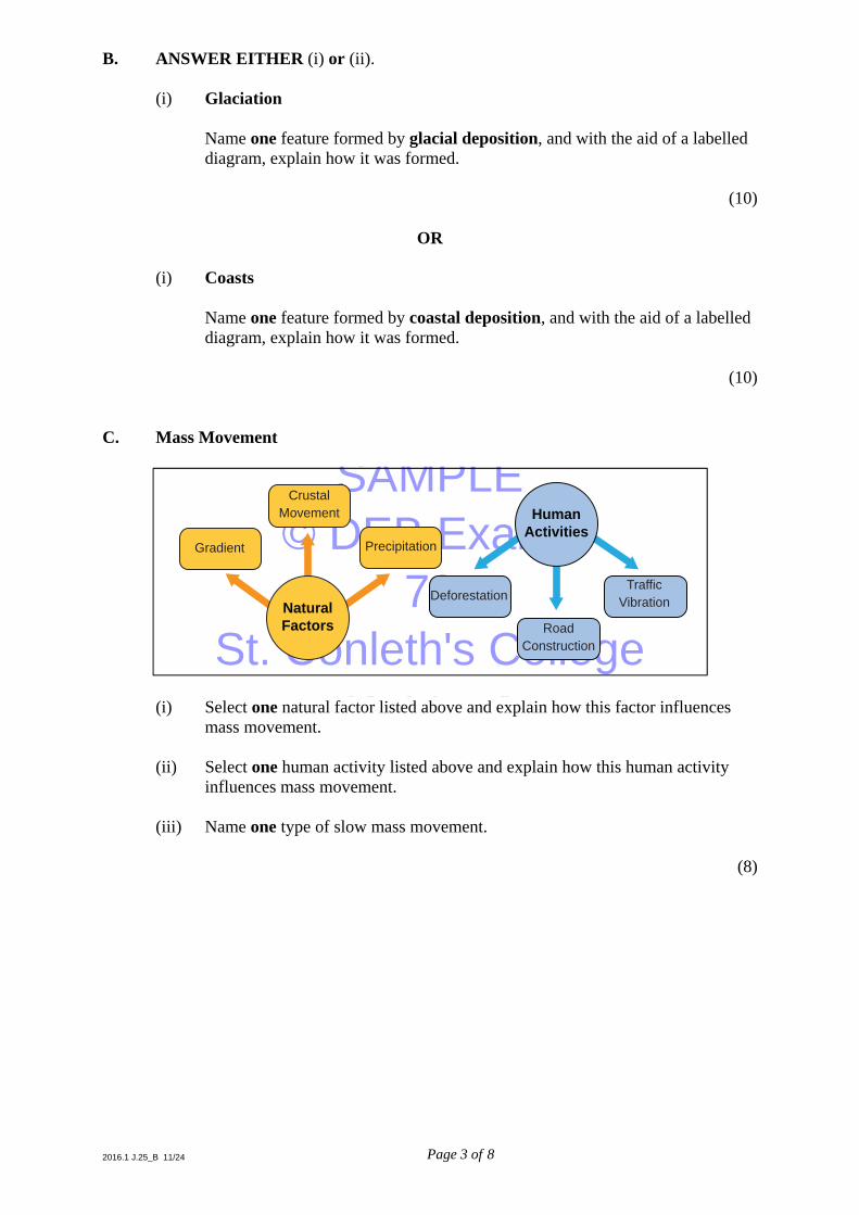
diagram, explain how it was formed. (10) C. Mass Movement
(i) Select one natural factor listed above and explain how this factor influences
mass movement. (ii) Select one human activity listed above and explain how this human activity
influences mass movement. (iii) Name one type of slow mass movement. (8)
NaturalFactors
Crustal Movement
Gradient Precipitation
HumanActivities
RoadConstruction
DeforestationTraffic
Vibration

SAMPLE© DEB Exams
72St. Conleth's College
Dublin 4
2016.1 J.25_B 12/24 Page 4 of 8
Question 2. THE RESTLESS ATMOSPHERE A. Weather
Examine the weather map above and answer each of the following questions. (i) What is the name given to the numbered lines shown on the map? (ii) What is the atmospheric pressure at A? (iii) Describe the weather conditions you would expect to find in Ireland on the map. (iv) Name the climate experienced by Ireland. (10) B. Climatic Factors Explain how any three of the following factors influence climate: ■ Latitude
■ Altitude
■ Distance from seas and oceans
■ Aspect
■ Prevailing winds. (10) C. Greenhouse Effect (i) With the aid of a labelled diagram, explain the greenhouse effect. (ii) Name two ways of reducing the greenhouse effect. (10)
TOMORROW, WEDNESDAY
1018
1034
1026
A
SAMPLE© DEB Exams
72St. Conleth's College
Dublin 4
2016.1 J.25_B 13/24 Page 5 of 8
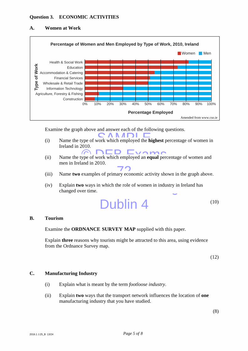
Question 3. ECONOMIC ACTIVITIES A. Women at Work
Examine the graph above and answer each of the following questions. (i) Name the type of work which employed the highest percentage of women in
Ireland in 2010. (ii) Name the type of work which employed an equal percentage of women and
men in Ireland in 2010. (iii) Name two examples of primary economic activity shown in the graph above. (iv) Explain two ways in which the role of women in industry in Ireland has
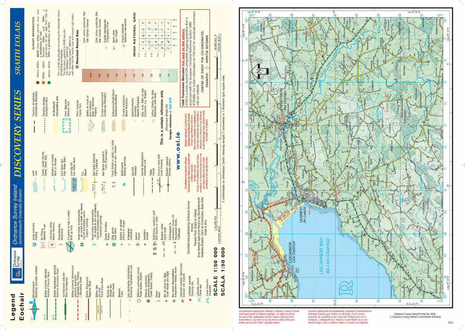
changed over time. (10) B. Tourism Examine the ORDNANCE SURVEY MAP supplied with this paper. Explain three reasons why tourists might be attracted to this area, using evidence
from the Ordnance Survey map. (12) C. Manufacturing Industry (i) Explain what is meant by the term footloose industry. (ii) Explain two ways that the transport network influences the location of one
manufacturing industry that you have studied.
(8)
MenWomen
Health & Social Work
Type
of W
ork
EducationAccommodation & Catering
Financial ServicesWholesale & Retail Trade
Information TechnologyAgriculture, Forestry & Fishing
Construction
Percentage Employed
Percentage of Women and Men Employed by Type of Work, 2010, Ireland
0% 10% 20% 30% 40% 50% 60% 70% 80% 90% 100%
Amended from www.cso.ie

SAMPLE© DEB Exams
72St. Conleth's College
Dublin 4
2016.1 J.25_B 14/24 Page 6 of 8
Question 4. GEOGRAPHICAL MIX Answer ANY THREE of the questions 4A, 4B, 4C, 4D. 4A. Soils (i) Name one Irish soil that you have studied. (ii) Describe the formation of this soil. (iii) Describe one way in which the soil type influences the type of
agriculture practised. (10) 4B. Unequal World
Examine the chart above and answer each of the following questions. (i) What percentage from the sale price of a banana goes to the workers? (ii) Explain two ways that unfair trade can hinder (slow down) economic
development in countries such as Cameroon. (10)
X% workers
20% plantation owners
13% importer
33% retailer
27% shipper
How the Sale Price of a Banana is Distributed
Banana from Cameroon (Africa)Amended from www.bananalink.org.uk
SAMPLE© DEB Exams
72St. Conleth's College
Dublin 4
2016.1 J.25_B 15/24 Page 7 of 8
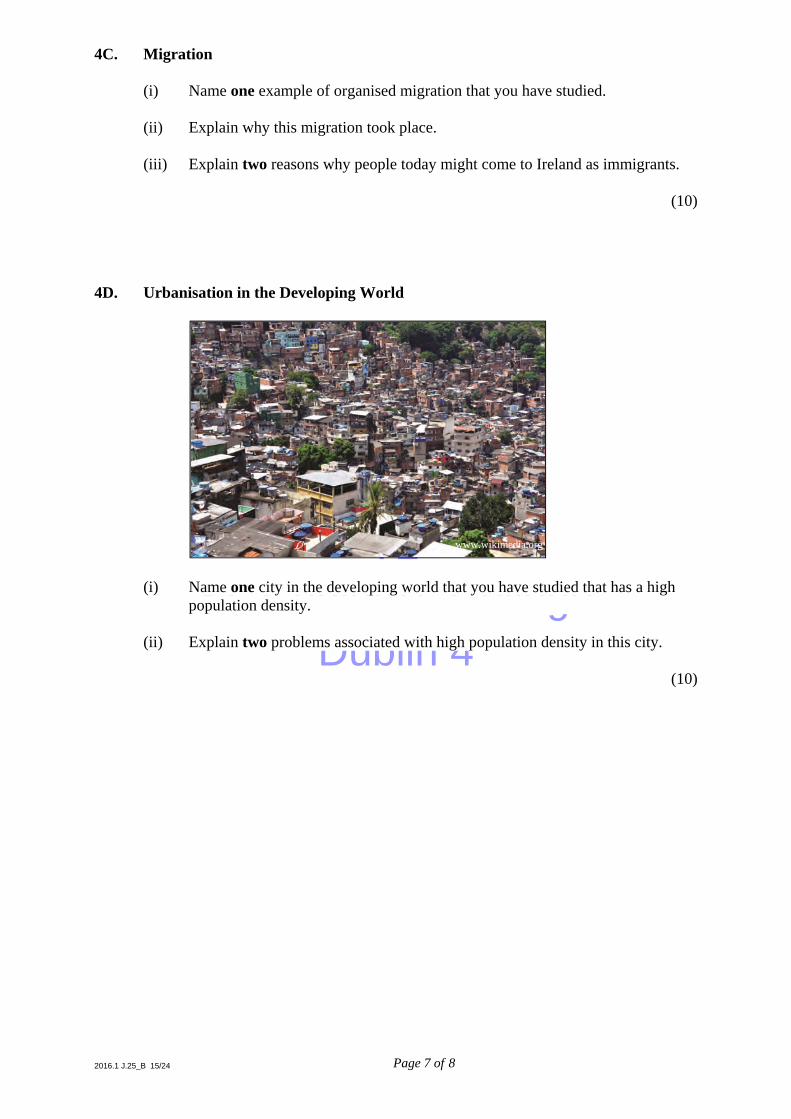
4C. Migration (i) Name one example of organised migration that you have studied. (ii) Explain why this migration took place. (iii) Explain two reasons why people today might come to Ireland as immigrants. (10) 4D. Urbanisation in the Developing World
(i) Name one city in the developing world that you have studied that has a high
population density. (ii) Explain two problems associated with high population density in this city. (10)
www.wikimedia.org

SAMPLE© DEB Exams
72St. Conleth's College
Dublin 4
2016.1 J.25_B 16/24 Page 8 of 8
Question 5. ORDNANCE SURVEY MAP AND AERIAL PHOTOGRAPH A. Examine the ORDNANCE SURVEY MAP supplied with this paper. Draw a sketch map of the area shown on the Ordnance Survey map. On your sketch map show and label each of the following: ■ The coastline
■ The built up area of Ennistimon
■ The Doolin Cycle Route
■ An area of coniferous plantation. (10) B. Examine the ORDNANCE SURVEY MAP supplied with this paper. Name, locate and explain, using six-figure grid references, two examples of historic
settlement on the map. (8) C. Examine the AERIAL PHOTOGRAPH supplied with this paper. A number of different land-uses are evident in the AERIAL PHOTOGRAPH. Name, locate and explain, using correct terms such as right background, etc., three
examples of different land-uses. (12)

SAMPLE© DEB Exams
72St. Conleth's College
Dublin 4
2016 Aerial Photo (Ennistimon) -01 (kg-final).qxp 10/06/2015 10:29 Page 1
SAMPLE© DEB Exams
72St. Conleth's College
Dublin 4
Unauthorised reproduction infringes Ordnance Survey Irelandand Government of Ireland copyright. All rights reserved. No part of this publication may be copied, reproduced or transmitted in any form or by any means without the prior written permission of the copyright owners.
Sáraíonn atáirgeadh neamhúdaraithe cóipcheart ShuirbhéireachtOrdanáis Éireann agus Rialtas na hÉireann. Gach cead arcosnamh. Ní ceadmhach aon chuid den fhoilseachán seo achóipeáil, a atáirgeadh nó a tharchur in aon fhoirm ná ar aonbhealach gan cead i scríbhinn roimh ré ó úinéirí an chóipchirt.
Ordnance Survey Ireland Permit No. 9039.© Ordnance Survey Ireland / Government of Ireland
2016
Long
. 09°
24'
WLo
ng. 0
9° 1
4' W
20'
15'
190000 181000
1 0500
006
0708
0910
1112
1314
1516
171 18
000
181
000190
000
1 0500
006
0708
0910
1112
1314
1516
171 18
000
89 88 87 86 85 84 83 82
88 87 86 85 84 83 82
Long
. 09°
24'
W20
'15
'Lo
ng. 0
9° 1
4' W
N
89
Lat. 55° 57' W 55' Lat. 55° 53' W
Lat. 55° 57' N 55' Lat. 55° 53' N
LIS
CA
NN
OR
BAY
Bá
Lios
Cea
nnúi
r