Embed Size (px)
Citation preview
SAMPLE PROFILE
Vimala. M “Determinants and impact of modern technology adoption in agriculture -A case study of Trichur district ” Thesis. Department of Economics, Dr. John Matthai Centre , University of Calicut, 1999

C H A P T E R - 4
SAMPLE PROFILE
4.1 PROFILE OF THRISSUR DISTRICT
4.2 DESIGN OF THE SAMPLE
4.3 PROFILE OF THE STUDY AREA
4.4 SOCIO-ECONOMIC PROFILE OF THE SAMPLE
CHAPTER - 4
SAMPLE PROFILE
This Chapter includes 3 Sections. The First Section
deals with the Profile of Thrissur District. Sample design
and profile of study area are discussed in the Second Section.
The last Section describes the socio-economic profile of the
sampl e.
4.1 Profile of Thrissur D i s t r -
Thrissur is one of the Fourteen Districts of Kerala.
It came into existence on 1st July 1949. It is known as the
cultural capital of Kerala.
4.1 . l - Location
Thrissur District lies between latitude 10' 10' X 10°46'
and longitude 7 6 O 57' X 76' 54' in the central part of Kerala
and is surrounded by Arabian Sea on the West, Coimbatore District
of Tamil Nadu and Palakkad District in the East, Malappuram and
Palakkad Districts in the north and Ernakulam and Idukki Districts
in the South.
Admini strati ve Set-up 4.1.2
The District i s divided into 5 Taluks. They are
Thal appi l l y , Thri ssur , Chavakkad, Kodungal l ur and Mukundapuram.
The Headquarters of these taluks are at Wadakkanchery , Thri ssur,
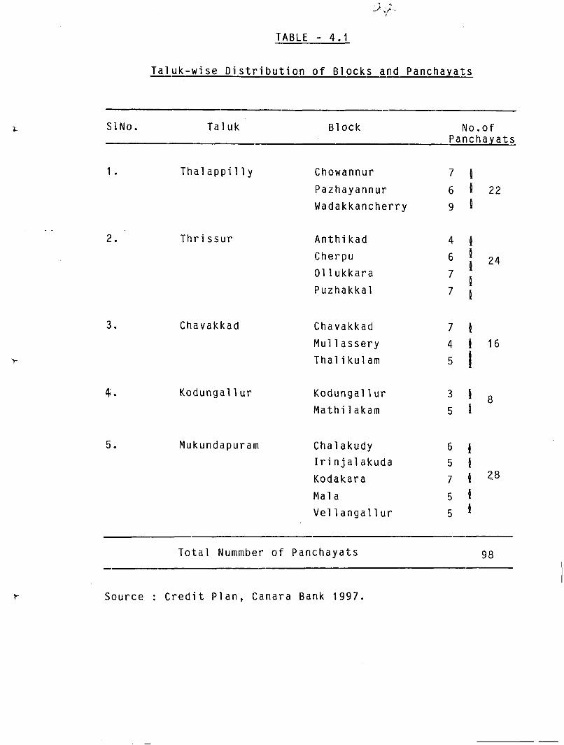
TABLE - 4.1
T a l u k - w i s e D i s t r i b u t i o n o f B l o c k s and Panchaya ts - -
SlNo. T a l u k B l o c k No.of Panchaya ts
1. Tha l a p p i l l y Chowannur 7 P Pazhayannur 6 P 22
Wadakkancherry 9 P
T h r i s s u r
Chavakkad
A n t h i kad
Cherpu
01 l u k k a r a
Puzhakka l
Chavakkad 7 11 Mu1 l a s s e r y 4 1 16
Tha l i k u l am 5 1 Kodungal l u r Kodungal l u r
M a t h i lakam L 8
5 P
Mukundapuram Chalakudy ti P I r i n j a l a k u d a 5 P Kodakara 7 ?g
Mal a 5 P Vel l anga l l u r 5 P
T o t a l Nummber o f Panchaya ts
Source : C r e d i t P l a n , Canara Bank 1997.
Chavakkad, Kodungal l ur and I r i n j a l akuda r e s p e c t i v e l y . T h e s e
t a l u k s are f u r t h e r d i v i ded i n t o 255 r e v e n u e v i l l a g e s s p r e a d i n g
o v e r 98 P a n c h a y a t s . T h e r e are 7 M u n i c i p a l i t i e s - T h r i s s u r ,
Chal akudy, Kodungal 1 u r , I r i n jal akuda , Kunnamkul am, Chavakkad
and Guruvayur , F o r imp1 ementi ng developmenta l schemes of
t h e Government t h e D i s t r i c t i s d i v i d e d i n t o 1 7 NES Blocks .
Tal uk-wi se d i stri b u t i o n of B1 o c k s and P a n c h a y a t s are g i v e n
i n T a b l e 4.1.
4.1.3 Topography
Topograph ica l l y t h e D i s t r i c t h a s t h r e e d i s t i n c t r e g i o n s
- t h e h i g h l a n d , t h e mid land and t h e lowland. A l l t h e s e
t h r e e r e g i o n s are found i n T h r i s s u r and Mukundapuram Ta luks .
Thal app i l l y Tal uk c o n s i sts of b o t h t h e h i g h l a n d and mi d l and
r e g i o n s w h i l e Chavakkad and Kodungal lur T a l u k s l i e i n low
1 and r e g i o n s .
I n h i g h l a n d s , t h e mounta in r a n g e s w i t h t h i c k f o r e s t s ,
v a l u a b l e trees l i k e t e a k , ebony a r e grown. The main c r o p s
i n h i g h l a n d s are tea, coffee and r u b b e r . I n m i d l a n d s . c o c o n u t ,
a r e c a n u t , cashew a n d o t h e r p e r e n n i a l c a s h c r o p s are grown.
A number o f streams make t h e low l y i n g a r e a f e r t i l e .
4.1.4 water Resources
The District i s s i t u a t e d between two l o n g e s t r i v e r s ,
Bhara thapuzha i n t h e n o r t h and P e r i y a r i n t h e s o u t h .
Chalakudy, Karuvannur and Kecheri are the main rivers of the
Di s t r i c t . Puthenthodu in Thri ssur Tal u k , Can01 i Canal in
Chavakkad tal uk and Shanmukham Canal in Mukundapuram tal uk
are the important waterways in the dis t r ic t .
4.1.5 Climateand Rainfall
The climate in the d i s t r i c t i s tropic with uniform
temperature t h r o u g h o u t the year. I t recei ves southwest
monsoon from June t o September and northeast monsoon from
October t o November. The res t six months from December t o
May are considered t o be d r y months t h o u g h the pre-monsoon
showers are received during April and May. The average normal
rainfall i s about 31.77mm.
4.1.6 Soil
The soil of the d i s t r i c t i s broadly divided into four
types name1 y sandy, a1 l uvi a1 , l ateri t e and forest soi l . The soil of the coastal taluks of Kodungallur and Chavakkad
vary from almost p r e sand t o sandy loan and are deficient
in a l l major plant nutrients. The alluvial soil occur in
the low lying areas of Thrissur and Mukundapuram taluks and
i s well enriched with organic matters, nitrogen and potash,
b u t deficient in phosphorous and calcium.
Coconut i S the predominant perennia: crop grown in sandy
be1 t. Seasonal crops l i ke tapioca, banana and vegetables
331. 137Q1$-2 VIM la are grown i n the midland regions, where l a t e r i t e s o i l i s
abundant. I n back water areas, s o i l . i s loamy type and f e r t i l e
due t o sedimentation.
4.1 .7 Popul a t i on
According t o 1991 Census, Thrissur D i s t r i c t i s having
a populat ion of 27.34 lakhs, out o f which 20.15 lakhs are
i n r u r a l area. The r a t e o f growth recorded dur ing the decade
1981-91 was 12.08 percent against the State growth r a t e o f
13.98 percent. The density o f populat ion as per 1991 census
i s 902 per sq.Km. as against 747 per Sq.Km. i n the State.
4.1.8 Land Use Pat tern i n t h e Di s t r i c t
The data on land use pat tern i s given i n Table 4.2.
Total geographical area o f the d i s t r i c t i s 299390 hectares
which forms 7.71 percent o f the t o t a l area o f the State.
Area under f o res t has decreased by 21.28 percent during l a s t
two decades. But land pu t t o non-agricul t u r a l uses has
increased by 52.16 percent dur ing the same period. Net sown
area o f the d i s t r i c t i n 1994-95 was 61004 hectares which formed
only 6.87 percent of the ne t sown area o f the State.
4.1.9 Agr icu l ture
Agr icu l ture continues t o be the main economic a c t i v i t y
o f the people i n the d i s t r i c t . More than h a l f o f the income
102
TABLE - 4.2
Land Use Pattern in the District - 1994-95
Particul ars Area (in Hectares)
Total Geographical Area
Forest
Land put to non-agricultural uses
Barren and uncul ti vabl e l and
Permanent pastures and grazing land
Land under miscellaneous tree crops
Cul ti vabl e Waste
Fallow other than current fallow
Current f a1 low
Net area sown
Area more than once
Total cropped area
Source : Credit Plan, Canara Bank 1997.
i S generated from Agriculture and a1 l ied activities. Only
35 percent of the total workers are having full time employment
in this important sector.
The main crops cultivated in the district are rice,
coconut, arecanut, tapioca, rubber, banana, cashewnut, pepper
and pulses. Area and productivity of these crops during
the period from 1985-86 t o 1993-94 are given in Table 4.3
The most important crop in the district i s paddy.
Three crops namely Virippu, Mundakan and ~ u n j $ are raised
in certain areas of the district in a year. One of the
striking features of the agricutural operations in the dis t r ic t
i s the 'Kale Cultivation1. Though area under rice has
decreased from 95215 hectares in 1985-86 t o 62144 hectares
in 1994-95 (34.73%), i t s productivity has increased from +
1595.7 Kg. per hectare t o 1835.4 Kg per hectare (15.02%) during
the same period.
Coconut i s an important cash crop which can be . considered as a dryland crop. Both the area and productivity
of coconut have increased during 1985-86 - 1994-95. Arecanut
and rubber also showed an increase in their area and
* The sowing and harvesting periods of the three rice seasons in Kerala are as follows :-
S O W ~ ng. Har vosti nq
Virippu (Autumn) April - May September - October Mundakan (Winter) Sept. - Oct. December - January Punja (Summer) Dec. - Jan. April - May.
TABLE 4.3
AREA (Ha) AND PRODUCTIVITY (KgIHa) OF IMPORTANT CROPS IN THE DISTRICT
Source : Economic Review (Various Issues)
YEAR
1985-86
1986-87
1987-88
1988-89
1989-90
1990-91
1991-92
1992-93
1993-94
1994-95
A
60366
61200
69715
74198
77452
80856
84789
85600
871 18
86206
A
95215
89527
84176
78862
74451
74038
69065
67151
63508
62144
COCONUT
P ( ~ u t s l ~ a )
61 12.7
5098.0
5393.4
6940.9
6830.0
5751.0
6439.5
7406.5
6749.5
7122.4
RICE
P
1595.7
1600.6
1554.9
1558.3
1674.9
1746.2
1762.4
1777.1
1726.2
1835.4
ARECANUT
A
6165
5982
6569
6023
5670
5670
5421
5721
6582
6637
P
191.4
196.9
204.0
207.5
192.6
212.3
272.1
244.7
222.7
298.6
A
3739
3876
4481
471 1
5472
5657
5747
5596
5171
4983
PEPPER
P
151.4
252.1
284.5
121.6
156.6
189.1
166.7
173.7
154.7
149.5
A
7790
7164
5807
6159
6294
5637
5549
5793
5524
5039
CASHEWNUT
P
356.1
499.4
532.8
522.2
508.1
548.1
637.4
611.4
382.7
563.8
A
9493
10048
8992
8784
7778
6861
6753
7571
12264
12493
RUBBER
P
675.4
654.9
847.1
962.1
1248.4
1603.4
1503.3
1399.0
1030.6
1103.8
A
5515
5446
4510
4147
3756
3360
3101
3330
2114
TAPIOCA
P
11829.9
16349.9
16740.6
4424.14379.5
16079.1
19030.4
16620.2
17441.5
15440.8
21292.2
A
5180
5429
5337
5548
6190
6284
6087
6455
6921
7063
BANANA
P
4727.0
5806.2
5666.3
5420.2
5642.3
6750.8
6418.9
5676.7
6057.7
7109.3
A
2402.0
2420.0
1939.0
1789.0
1590.0
1797.5
1058.0
919.0
598.0
549.0
PULSES
P
714.0
714.0
713.8
714.9
715.1
701.3
715.5
716.0
715.7
715.8

105
productivity during thi S decade.
There was a gradual decline in the area of cashewnut,
tapioca and pulses in the district. But their productivity
has increased over thi S period. Pepper showed fl uctuatioris
in its productivity though i tls area has increased.
Irrigation
Distribution of gross irrigated area in the District *
under paddy and coconut is given in Table 4.4. Gross
irrigated area under paddy has declined from 55840 hectares
in 1986-87 to 37300 hectares in 1994-95. In other words,
while it formed 18.71 percent of gross irrigated area under
paddy in the state in 1986-87 it was only 13.67 percent of
the same in 1994-95. At the same time gross irrigated area
under coconut has increased from 28914 hectares to 48855
hectares (68.97%) during the same period.
When we compare total irrigated area to the total
cropped area in the district, it has risen from 41.81 percent
in 1986-87 to 53.95 percent in 1994-95. While the proportion
of gross irrigated area under coconut to total area under
coconut has increased from 47.25 percent to 56.67 percent,
it showed a decrease from 62.37 percent to 58.73 percent
in the case of paddy during the period under study.
4.1 . l 1 Planting Materials
The centres for the distribution of planting
materials in the district are Seed Farm, Mannuthy, State
TABLE - 4.4
Gross Irrigated Area in Thrissur District
(~ectares)
Year Gross irrigated Gross Irrigated area Total Irri- area under paddy under coconut gated area
Note : Figures in parantheses indicate percentage of the corresponding area in the State.
Source : Economic Review (Various issues).
Seed Farms situated i n Kodassery , Nadavaramba, Edathuruthy ,
Pananchery and Pazhayannur and Coconut Nurseries situated in
Wadakkanchery, Irinjalakuda and Chelakkara. The materi a1 S
avai l abl e from Seed Farm Mannuthy are Coconut Seedl i ngs, rooted
pepper cutti ngs, Fruit P1 ants, Clove and Nursery Seedl i ngs,
Vegetable Seeds, Pulses Seed and Paddy Seeds. State Seed
Farms di stri bute 9addy seed and coconut seed1 i ngs. Detai l S
of paddy seed production in 1994-95 by the State Seed Farms
are given in Table 4.5.
4.1 . l 2 Aqri cul tural Machi neries
Agriculture machi neries are supplied through different
scheaes in the district. Number of different machineries
distributed in the district in the years from 1991-92 to 1994-
95 is given in Table 4.6.
4.1 .l3 -- Ferti l i sers
Farmers in the district use both organic and inorganic
manures. Consumption of fertilisers in Thrissur District
during 1986-91 i S given in Table 4.7. Consumption of Nitrogen
and Potash has decreased during this period. But consumption
of Phosphorous h3s remained at the same level without much
f l uctuati ons.
TABLE - 4.5
D e t a i l s o f Paddy Seed P r o d u c t i o n - 1994-95
I n s t i t u t i o n No. 'Season V a r i e t y Seed O b t a i n e d
(Kg . )
1. S t a t e Seed Farm, Kodassery
2. S t a t e Seed Farm, E d a t h u r u t h y
3. S t a t e Seed Farm, Pazhayannur .
4. S t a t e Seed Farm, Nadavaramba
5. S t a t e Seed Farm, Mannuthy.
6. S t a t e Seed Farm, Pananchery
V i r i p p u (Red T r i v e n i , ( J y o t h i
Mundakan (Red T r i v e n i ( J y o t h i
P u n j a ( J y o t h i
V i r i p p u ( J y o t h i
Mundakan (Red T r i v e n i ( N e e r a j a
V i r i ppu (Red T r i v e n i ( J y o t h i
Mundakan Red T r i v e n i [ J y o t h i
V i r i p p u (Red T r i v e n i
Mundakan ( J y o t h i
V i r i p p u li?it:!Larn
Mundakan ( J y o t h i (Red T r i v e n i
V i r i p p u ( J y o t h i
Source : Deputy D i r e c t o r o f A g r i c u l t u r e f o r P r i n c i p a l A g r i c u l t u r a l O f f i c e r .

TABLE - 4.6
Details of Aqricultural Machineries Supplied through
Agriculture Department (Thrissur ~istrict)
Scheme Details No. 1991 -92 1992-93 1993-94 1994-95
1 . Group Farming
Power Ti l l er 10 2 1 - - Tractor 46 15 - - Thresher 30 10 - -
2. I.P.R.D. - -
Power Ti l l er 52 90 3 1
3. Prime Minister's scheme
Power Ti l l er - 112 - Thresher - 179 -
4. Special Component Plan for SCIST.
Power Ti l l er 3 - - Tractor - 1 1 Thresher - - 2
5. Agro Service Centre - Supply of Tractors, Tillers and other farm machi neri es at subsidised rate.
Power T i l l er 4 Tractor -
6. Distribution of improved Agricultural implements.
Power Tiller - 11 - Thresher - 5 -
7. Promotion of Agricultural Machanisation - Supply of Tractors upto 18 HP.
Tractor - 2 - - 8. Small Farm Machani sation
Tractor - - 1 -
15 Power Ti l l er - 2 1 14 Thresher - - - - 5 4 - 10 W i nnover 2
Source : Agriculure Department.
TABLE - 4.7
Consumption of Ferti l i sers in Thri ssur D i s t r ic t
(Metric Tonnes)
Ferti l i sers 1986-87 1987-88 1988-89 1989-90 1990-91
Nitrogen 3849.91 3292.70 3068.00 3119.00 2808.29
Phosphorous 1513.90 1551.80 1544.50 1487.00 1519.76
Potash 301 1.71 2976.10 2847.00 2366.00 2452.67
Source : Agriculture Department.
111
4.2 besi gn o f the Sample
The present study i s r e s t r i c t e d t o Thrissur D i s t r i c t
which consists of f i ve ta luks. One block from each t a l u k
i s selected based on the information t h a t the main crops
c u l t i v a t e d i n these blocks are paddy and coconut. The selected
blocks are Mal a, Chavakkad, Mathi 1 akam, Puzhakkal and
Wadakkanchery. Then two Panchayats from each block have
been selected and thus the study i s confined t o 10 Panchayats.
F i na l l y , 10 farm households from each panchayat are drawn
randomly t o cons t i t u t e a t o t a l o f 100 farm households. Thus
a mul t is tage random sampling method has been adopted i n the
present study.
Out o f 100 households selected, only 85 households
are c u l t i v a t i n g paddy whi le a l l o f them have coconut
c u l t i v a t i o n . To s ta te spec i f i ca l l y , i n Mathi lakam Block,
the coconut c u l t i v a t o r s outnumber the paddy c u l t i v a t o r s due
t o the pecul i ar nature o f the soi l . So we could f i n d only
5 paddy c u l t i v a t o r s instead o f 20 from t h i s block.
4.3 P r o f i l e o f the Study Area
4.3.1 Mala Block
Mala block l i e s i n Mukundapuram ta l uk which consists
o f 14 v i l l ages and 5 panchayats. Geographical area o f t h i s
block i s 126.71 Sq.Kms. which forms 4.18 percent o f the area
o f the d i s t r i c t . According t o 1991 Census t o t a l populat ion
i n t h i s b lock i s 133734. Administ rat ive d e t a i l s o f the b lock
i s presented i n Table 4.8. Out o f 5 panchayats, Annamanada
and Mala Panchayats a re selected f o r t he study.
4.3.1 .1 PbIa Grama Panchayat
(a) General Features
Mal a Grama Panchayat includes Kuruvi tti ssery , Vadama-
North and .Annall u r V i l l ages. Total geographical area under
t h i s Panchayat i s 28.35 Sq.Kms. which forms 22.37 percent o f
the Block area. This Panchayat i S bounded by Aloor Panchayat
i n the north, Annamanada Panchayat, Chal akudy Munici pal i t y
and Kadukutty Panchayat i n t h e east, Kuzhur Poyya Panchayats
i n the south and Puthenchira Panchayat i n the west. There
are 12 wards i n t h i s Panchayat. Total populat ion o f t he
Panchayat i s 30787 which cons is ts o f 47.73 percent male and
52.27 percent female.
(b) Agr icu l tu re
Paddy and coconut are the main crops c u l t i v a t e d i n
the Panchayat. Arecanut, Banana, Mangotree and Cashew are
a1 so cu l ti vated as i ntercrops.
Area under coconut i s the l a rges t (1755 hectares) and
the second place goes t o the paddy crop which cons t i tu tes 1212
hectares. Three crops o f paddy - Vir ippu, Mundakan and Punja
are c u l t i v a t e d i n t h i s Panchayat and area under these crops
113
bear 40.43 percent, 43.89 percent and 15.68 percent
respect i vel y .
Agr icu l tu ra l implements and p1 an t i ng mater ia l S are
d i s t r i buted through K r i shi Bhavan f o r the devel opment o f these
crops. The d i s t i buted imp1 ements i ncl ude Pumpset, Rocker
Sprayer, Climbing device etc. The seedlings o f coconut, f r u i t
trees,clove and cinnamon are a l so d is t r ibu ted .
- -
Chalakudy Puzha i s the only i r r i g a t i o n source o f t he
Panchayat and the def ic iency o f i r r i g a t o n f a c i l i t i e s i s one
o f the. reasons for the dec l ine i n the area under c u l t i v a t i o n .
4.3.1.2. Annamanada Grama Panchavat
(a) General Features :
Annamanada Panchayat l i e s i n the south-east reg ion
Mala Block w i th 11 wards. A1 athur and Kal l ur-Thekkumuri
are the v i lages i n the Panchayat. Total geographical area
o f tne Panchayat i s 25.08 sq.km which forms 19.79 percent o f
the block area and t o t a l populat ion i n the Panchayat i s 26448
with sex r a t i o 1037. Populat ion density o f the Panchayat i s
1054 per Sq. Km.
(b) Agr i cu l tu re :
Paddy, coconut, arecanut, p1 antai n, pepper and rubber
are the crops c u l t i v a t e d i n the Panchayat. Paddy i S c u l t i v a t e d
114
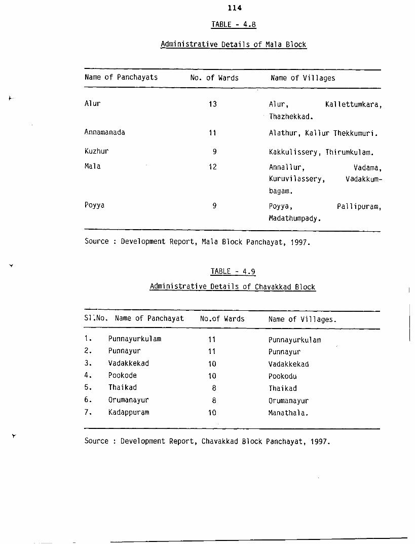
TABLE - 4.8
Admi n i s t r a t i ve Detai l S o f Mal a B1 ock
-
Name o f Panchayats No. o f Wards Name o f V i l l ages
Annamanada
Kuzhur
Mal a
13 A1 u r , Kal l ettumkara , Thazhekkad.
1 1 Alathur, Ka l l u r Thekkumuri.
9 Kakkul i ssery , Thirumkul am.
12 Annal l ur , Vadama , Kuruvi l assery , Vadakkum-
bagam.
PoYYa, Pal l i puram, Madathumpady .
Source : Development Report, Mala Block Panchayat, 1997.
TABLE - 4 .g
Administ rat ive De ta i l s o f Chavakkad Block
-
S11No. Name o f Panchayat No.of Wards Name o f Vi l lages.
1. Punnayurkul am 11 Punnayurkul am 2. Punnayur 11 Punnayur
3. Vadakkekad 10 Vadakkekad
4. Pookode 10 Pookodu
5. Thai kad 8 Thai kad
6. Orumanayur 8 Orumanayur
7. Kadappuram 10 Manathala.
Source : Development Report, Chavakkad B1 ock Panchayat, 1997.
i n an area o f 1250 hectares under three crops - V i r ippu (22
percent), Mundakan (42 percent) and Punja (36 percent).
Area under coconut i s 1500 hectares w i t h an average product ion
o f 2000 nuts per hectare. Arecanut, rubber and pepper are
the other cash crops c u l t i v a t e d i n the Panchayat under the
area o f 100 hectares, 35 hectares and 100 hectares respect i vely . Kr i sh i Bhavan gives assistance t o the farmers by prov id ing
i r r i g a t i o n f a c i l i t i e s , ag r i cu l t u ra l implements and seed1 ings
f o r the deveopment o f ag r i cu l ture.
4.3.2 Chavakkad B1 ock
It i s one o f the blocks i n Chavakkad Taluk. There
are 2 Mun ic ipa l i t i es , 7 v i l l ages and 7 panchayats under t h i s
block and i t s t o t a l geographical area i s 86.21 sq.km. (1 .e.
2.84 percent o f the d i s t r i c t area). Total populat ion i s 1.59
l akhs according t o 1991 census. Admini s t r a t i ve d e t a i l S are
as shown i n Table 4.9. O f the 7 Panchayats, Punnayurkulam
and Vadakkekad Panchayats are included i n the study area.
4.3.2.1 Punnayurkulam Grama Panchayat
(a) General Features
Punnayurkulam Panchayat l i e s nor th t o Thrissur D i s t r i c t
and i t i s a lso i n the northmost end o f Chavakkad Block. Th is
panchayat consists o f an area o f 18.71 sq.kms. (i.e. 21.70
percent o f the block area) and there are 12 wards al together
i n the Panchayat. Tota populat ion o f the panchayat i S 29795.
116
Land records of the panchayat reveals t h a t 54.11 percent of
total area i s under cultivation.
(b) Agriculture
Paddy and coconut are the important crops cultivated
i n the Panchayat. Of the three paddy crops, area under Punja
crop i s larger and also productivity of this crop i s highest
of 3.5 tonnes per hectares. Coconut i s cultivated in 252 -
hectares which provides 40 nuts per coconut. Arecanut, pulses
topioca, plantain etc. are the other crops cultivated i n this
area.
Assistance for agricultural development i S avai l able
through 'Kri shi Bhavan l . Agricultural implements l i ke
tractors, t i l lers, sprayers, cl imbi ng devices etc. and
seed1 i ngs of coconut, banana, mangotree and pepper are
supplied through Krishi Bhavan. About 98 percentage of
farmers in the Panchayat are small farmers having cultivated
land area of below 1 hectare.
4.3.2.2. Vadakkekad Grama Panchayat
( a ) General Features
Vadakkekad Panchayat i s situated in the north to
Thrissur District. Total area of this Panchayat i s 13.72
Sq.Kms i .e., only 0.45 percent of the d i s t r i c t area and total
population in the Panchayat i s 23575 with sex rat io 1134.
There are 10 wards in th is panchayat and Vadakkekad Village
comes under thi S Panchayat.
(b) Agriculture
Main crops cultivated in th is panchayat are paddy
and coconut. Area under paddy has decl i ned from 407 hectares
to 300 hectares during the las t decade. There are various
reasons for th is and some of them are increase i n the cost
of production, inadequacy of irrigation fac i l i t i es , increased
demand for housing plots etc.
Area under coconut in the panchayat i s 850 hectares.
Also i t s productivity has decreased because of certain
diseases like leaf ro t t , stem bleeding, root wilting etc.
and inadequate of water.
4.3.3 Mathi l akam B1 ock
Mathilakam Block i s under Kodungallur taluk. I t
i S composed ' of 9 vi l l ages and 5 panchayats. Geographical
area under th is block i s 71.81 Sq.Kms. which forms 2.37
percent of the d i s t r i c t area. I t i s bounded by Arabian
Sea in the west, Tal i kulam Block in the north, Vel langal lur
Block in the east and Kodungallur Municipality in the south.
According t o 1991 census, total population in the block i s
137386 w i t h sex rat io 1136 and population density i s 1913
118
Sq.Kms. There are 5 panchayats w i t h 53 wards and 9 v i l l a g e s
i n t h e block. The admin i s t ra t i ve d e t a i l s a re g iven i n
Table 4.10. Mathi l akam and Sreenarayanapuram panchayats
a re t h e se lec ted panchayats f o r sample study.
4.3.3.1 Mathi l akam Grama Panchayat
(a) General Features
Mathilakam Panchayat i s i n t h e southern p a r t of
Mathilakam Block. It cons is ts o f Pappanivattom V i l l a g e
and the re are 10 wards i n the panchayat. Tota l area o f
t h e Panchayat i S 12.92 sq.kms and the re i S a t o t a l popu la t ion
o f 25417 w i t h sex r a t i o 1151. Density o f popu la t ion i s
1967 per sq.km.
(b) Agr i c u l t u r e
Coconut i s t h e main crop i n t h e Panchayat. Area
under coconut i S 1095 hectares and i t s p r o d u c t i v i t y i s 5900
nuts per hectare. Paddy c u l t i v a t i o n was i n a s a t i s f a c t o r y
s t a t e till 1960. But now t h e area under paddy has dec l ined
t o a very low l e v e l o f 13 hectares w i t h p r o d u c t i v i t y 800
Kgs. per hectare. This i s because o f severe f l o o d i n t h e
area. Pepper, arecanut and vegetables are a1 so c u l ti vated
i n t h i s Panchayat.
4.3.3.2 Sreenarayanapuram Grama Panchayat
S.N.Puram Panchayat i s i n t h e southernmost end o f
Mathi l akam Block. Panangad, A l a and Padi n j a r e Vembal l u r
TABLE - 4.10
Admi ni strati ve Detai l S of Mathi l akam B1 ock
S1 .No. Name of Panchayats No.of wards Name of Villages
1. Kai pamangal am 11 Kai pamangal am
2. Edathuruthy 11 Edath~ruthy~chendrappinni.
3. Mathi l akam 10 Pappi ni vattom
4. Sreenarayanapuram 12 Panangad, A1 a, Padi n jara Vembal l ur .
.- -
5. Perinjanam 9 Peri n janam, Kool imuttom.
Source : Development Report, Mathilakam Block Panchayat, 1997.
TABLE - 4.11
Admini strati ve Detai l S of Puzhakkal Block
S1,No. Name of Panchayats No. of wards Name of Villages
1. Adat
2. Arimpur
3. ~ ~ ~ a n t h o l e
4. Avanur
5. Kai paramba
6. Killannur
7. Tholur
10 Puzhakkal , Puranattukara, Chi tti l appal l y , Adat.
10 Manakody, Veluthur, Eravu, Parakkad.
14 Aranattukara (Portion) Pul l azhi , Poonkunnam, Thri ssur (Portion), Ayyanthol e (Portion).
8 Avanur , Thangal oor, Chool i ssery , Vel appaya.
10 Kai paramba, Peramangal am, Anjur.
8 K i l l anur
8 Tholur, Edakolathur,Chavakad
Source : Development Report, Puzhakkal Block Panchayat, 1997.
120
Villages are included in this Panchayat. There are 12 wards
in this panchayat and i t s total geographical area i s 19.26
sq.Kms which bears 26.82 percent of the block area. Total
population in the panchayat i s 34878 with sex ratio . l 115
and density of population 1811 per sq.km.
(b) Agri cul ture
Coconut i s the main crop which constitutes 1928
hectares of area with productivity of 7884 nuts per hectare.
Kri shi Bhavan provides assi stance for the development of
coconut cul t i vation through different schemes. Paddy i S
cultivated in 15 hectares only, whose productivity i s 1000
Kg. per hectare. Arecanut, cashew and vegetables are the
other crops grown in the panchayat.
4.3.4 Puzhakkal B1 ock
Puzhakkal block l ies in the centre region of Thrissur
District. i t includes 7 panchayats with 68 wards and 24
villages. Total geographical area of the block i s 145.96
sq.km. which constitutes 4.8 percentage of the district area.
There i s a population of 164359 in the block with population
density of 1126 per sq. km and sex ratio 1060. The
administrative set u p of the block i s as shown in Table 4.11.
Puzhakkal block i s an important agricultural region
of Thrissur District. Paddy, coconut and banana are the
main c rops c u l t i v a t e d i n t h e block. Paddy i s c u l t i v a t e d
i n more t han 7000 hec t a r e s which c o n s t i t u t e s 10% o f t h e t o t a l
c u l t i v a t e d a r e a o f paddy i n t h e d i s t r i c t . Kole land spread
i n t h e Panchayats o f Adat, Ayyanthole, Arimbur and Tholur
i s t h e main source of paddy production. Coconut i s
c u l t i v a t e d i n more than 3000 h e c t a r e s of land.
4.3.4.1 Ayyanthole Grama Panchayat
( a ) General Fea tu re s :
Ayyanthole Panchayat l i e s i n t h e south-eas t p a r t o f
Puzhakkal B1 ock. I t i nc l udes Pul l azhi Vi l l age, Poonkunnam
Vi l l age, po r t i on of Aranat tukara, Thri ssur and Ayyanthole
Vi l lages . There a r e 14 wards i n t h e Panchayat. I t i s
a spec i a l g rade panchayat having 23.14 sq.km. a r ea which
forms 15.85 percent of t h e block a rea . Total populat ion
i n t h e panchayat i s 23571 with sex r a t i o 1069. Density
of populat ion i S 1971 per sq.km.
( b) Agr icu l ture :
Paddy a n d c o c o n u t a r e t h e ma in c r o p s o f t h e
P a n c h a y a t . T h r e e c r o p s o f p a d d y - V i r i p p u ,
Mundakan a n d P u n j a a r e c u l t i v a t e d i n t h e P a n c h a y a t .
According t o t h e p r o j e c t r e p o r t published by Puzhakkal Block
122
Grama Panchayat i n 1996, t o t a l area under paddy i n the
Panchayat. i S 900 hectares which cons t i tu tes 11.11 percent
of Virippu, 36.11 percent of Mundakam and 63.89 percent of
Punja Crops. Coconut i s cu l t iva ted under an area of 528
hectares which c o n s t i t u t e s 17.22 percent of t o t a l area under
coconut i n the block. Arecanut, p1 anta i n , pepper, cashew
and tapioca a r e t h e o ther crops cu l t iva ted i n t h i s Panchayat.
4.3.4.2 Adat Grama Panchayat
( a ) General Features :
Adat Panchayat i s i n the cent ra l pa r t of Puzhakkal
Block. I t c o n s i s t s of 10 wards and 4 v i l l ages of Puzhakkal ,
Puranattukara, Chi t t i lappal l y and Adat. Total geographical
area of t h e Panchayat i S 23.02 sq.km which forms 15.77 percent
of t h e block area. According t o 1991 census, t o t a l
population i n t h e Panchayat i s 23441 with sex r a t i o 1101.
Density of population i s 1018 per sq. km.
(b) Agriculture :
Paddy, coconut and banana a r e the main crops of t h e
Panchayat. Area under paddy i s 1535 hectares and area under
Punja crop i s more than (74.92 percent) t h a t of t h e other
two crops. Coconut i s cu l t iva ted under 385 hectares.
Arecanut, banana, pepper, cashew and vegetables a r e a l s o
grown i n t h e Panchayat.
4 -3 -5 Wadakka'nchery B1 ock
Wadakkancherry Block i s i n the nor th o f Thr i ssur
D i s t r i c t and i t consists o f 9 panchayats w i th 86 wards and
34 v i l l ages . Total geographical area o f the block i S 24870
hectares which forms 8.31 percent o f the d i s t r i c t area.
This block includes a t o t a l populaton o f 203544 w i th sex
r a t i o 1095 and density of populat ion 686 per sq.km.
Paddy and coconut are the main crops i n the block.
Paddy i s c u l t i v a t e d i n the area o f 10062 hectares which forms
70.73 percent of the ne t cropped area o f the block and i t s
p roduc t i v i t y i S 1.97 tonnes per hectare. Area under coconut
i S 4401 hectares w i th p roduc t i v i t y 4207 nuts per hectare.
Rubber, arecanut and p lan ta in are the other important crops
i n the block. Administrat ive set-up o f the block i s g iven
i n Tab1 e 4.12. Wadakkancherry and Vel u r are the, Panchayats
selected f o r the sample survey.
4.3.5.1 Wadakkancherry Grama Panchayat
(a) General Features :
Wadakkancherry Panchayat l i e s ' a t the cent ra l p a r t
o f the block which consists o f 11 wards. ~adakkanche r r~ ,
Enkakkad and Kumaranel l ur v i l l ages come under t h i S Panchayat.
It has a t o t a l area o f 1498.06 hectares which forms 6.02
percent o f the block area. It i s a special grade panchayat
w i t h a populat ion o f 28692 and sex r a t i o 1095. Density
o f the populat ion i s 1006 per sq. km.
TABLE - 4.12
Administrative Details of Wadakkanchery Block
Name of Panchayat No.of Wards Name of Villages. No.
p-- P -
Desamangal am Thal assery , Pal l ur, Desamangal am, Arangottukara.
Trichur, Pilakkad, Varavur. Varavur
Mundathi kode Puthuruthy, Mundathi kode, Par1 i kad, Peri ngandoor , Mi nal ur.
Wadakkancherry (Portion) , Enkakad Kumaranal l ur.
Thekkumkara Karumathara, Viruppaka, Manalithara, Thekkumkara.
Kadangode Kadangode, Vallarakad, Eyyal, Chi ramanangad.
Vel ur Vel ur, Vel l attanjur , Thayyur , Kirallur.
Mu1 l oorkara
Erumapetty
Mulloorkara, Attur.
Kanjirakode, Chittana, Kottapuram Nelluvaya, Kariyannur.
Source : Development Report, Wadakkancherry Block Panchayat, 1997.
( b ) Agriculture :
Paddy .and coconut are the main crops grown in the
Panchayat. Area under paddy i s 510 hectares and share of
the area under Virippu, Mundakan and Punja are 42.16 percent,
51.96 percent and 5.88 percent respectively . According t o
the Krishi Bhavan records, productivity of paddy in Virippu
seasons was 1.5 tonnes per hectare and t h a t in Mundakan and
Punja was 2 tonnes per hectare each. Other crops in the
Panchayat are coconut, arecanut, rubber and pepper. Coconut
i s cultivated under an area of 800 hectares and i t s productivity
i s an average of 50 nuts per palm.
4.3.5.2 Velur Grama Panchayat
a General Features :
Velur i s the f i r s t grade panchayat in Wadakkancherry
Block. I t l ies in the north-west p a r t of the block and spreads
over an area of 28.32 sq. km which forms 5.98 percent of total
area of the block. Total population of the panchayat i s 22155
with sex ratio 1118 and density of population 782 per sq. km.
There are 10 wards and 4 villages in the panchayat.
( b ) Agriculture :
Paddy, coconut and arecanut are the main crops in the
Panchayat with respective areas of 1145 hectares, 480 hectares
and 320 hectares respecti vel y . Paddy i S cultivated under
two crops of Virippu and Mundakan with productivities 2 tonnes
126
per hectare and 2.5 tonnes per hectare respectively. The
productivity of coconut i S 50 nuts per palm.
Socio-economic Profile of the Sample
For the present study, 100 farm households are selected
a t random from f ive blocks of Thrissur Distr ic t . The main
character is t ics of the sample population in terms of age, sex,
community, education and income are studied. Besides, the
area under paddy and coconut cultivation and the i r farm income
are a1 so described.
4.4.1. Population
The to ta l number of persons in the sample households
i s worked out t o 504. I t gives an average family s ize of
5.04 per household. O u t of them 274 (54.37 percent) are males
and 230 (45.63 percent) females. The sex r a t i o of the sample
i s t h u s 839.
Age-wi se classif icat ion of population i S given in Table
4.13. Of the sample population, 13.29 percent are below 15
years of age, 73.61 percent .come under the age group of 15-
60 and the remaining 13.10 percent are above 60 years.
From t h i s , we can conclude t h a t a large number of the sample
popul ation are constituted by potenti a1 labour force coming
under the age group of 15 t o 60.
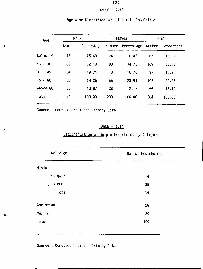
TABLE - 4.13
Age-wi se C l a s s i f i c a t i o n o f Sample Populat ion
Age MALE FEMALE TOTAL
Number Percentage Number Percentage Number Percentage
Above 60 38 13.87 28 12.17 6 6 13.10
Total 274' 100.00 2 30 100.00 504 100.00
Source : Computed from t h e Primary Data.
TABLE - 4.14
C l a s s i f i c a t i o n o f Sampl e Households by Re1 i gion
Re1 i g i o n
- -
No. o f Households
Hindu
( i ) N a i r
( i i ) OBC
Total
Chri s t i an
Musl i m
Tota l
Source : Computed from t h e Primary Data.
4.4.2 Community Composition
The c l a s s i f i c a t i o n of households by r e l i g i o n i s a s
shown i n Table 4.14.
The sample c o n s i s t s of 54 percent of Hindus, out of
which 35.19 percent belong t o Nair and 64.81 percent belong
t o o ther Backward Caste, 26 percent a r e Chr is t ians and t h e
remaining 20 percent belong t o Muslim Re1 igion.
4.4.3 Educational S t a t u s
Table 4.15 descr ibes t h e educational s t a t u s of
population.
O u t of t h e t o t a l population, 4.37 percentage come under
t h e age group of below 6 years . Of t h e remaining , 1.98 percent
a r e i l l i t e r a t e s , 9.33 percent have lower primary l eve1 of
education and 9.13 percent a t t a ined upper primary level of
education. Majority of t h e population (40.08 Percent) a r e
educated upto high school level and 15.08 percent a r e higher
educated a t degree level o r above.
4.4.4 Farmer S
In t h e present s tudy, one member from each family who
i S i n t e r e s t e d o r involved i n farming a c t i v i t i e s i S considered
a s ' fa rmer ' . Thus t h e r e a r e 100 farmers a l together i n t h i s
sampl e .

TABLE - 4.15
Educational Status o f Sample Populat ion
Educational MALE FEMALE TOTAL
Level Number Percentage Number Percentage Number Percentage
I 1 l i t e r a t e 1 0.38 9 4.09 10 2.07
Upto L.P. 27 10.31 20 11 .OO 4 7 9.75
Upto U.P. 2 1 8.02 2 5 11.36 46 9.54
H.S. Level 116 44.27 8 6 39.09 202 41.91
High Secondary 56 . 21.37 4 5 20.45 101 20.95
Degree & above 41 15.65 35 15.91 76 15.77
Tota l 262 100.00 220 100.00 482 100.00
Source : Computed from t h e Primary Data,.
TABLE - 4.16
Age Composition o f Farmers
MALE FEMALE TOTAL Age
Number Percentage Number Percentage
30 - 40 8 8.70 2 25 10
40 - 50 17 18.48 2 25 19
50 - 60 2 9 31.52 2 25 31
60 - 70 26 28.26 2 25 28
70 & above 10 10.87 0 0 10
Tota l 92 100.00 8 100 100
Source : Computed oy t h e Researcher.
130
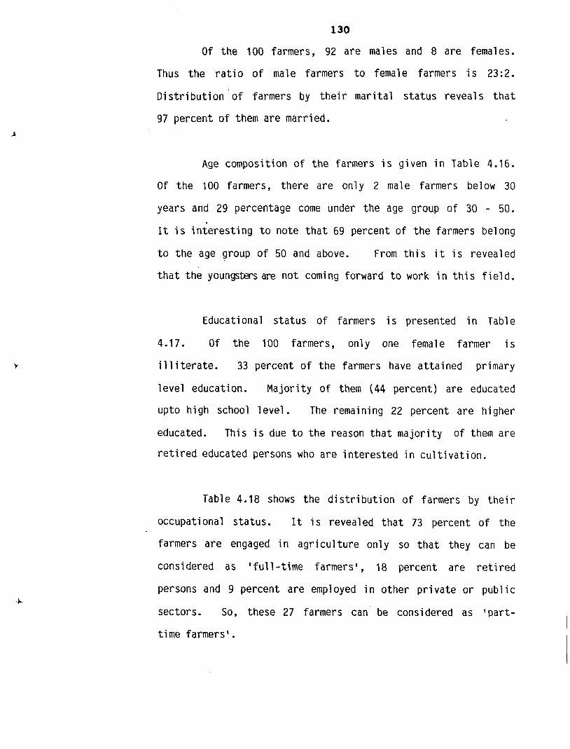
Of the 100 farmers, 92 are males and 8 are females.
Thus the ratio of male farmers to female farmers i s 23:2.
Distribution of farmers by their marital status reveals that
97 percent of them are married.
Age composition of the farmers i s given in Table 4.16.
O f the 100 farmers, there are only 2 male farmers below 30
years and 29 percentage come under the age group of 30 - 50.
I t i S interesting to note t h a t 69 percent of the farmers be1 ong
to the age group of 50 and above. From this i t i s revealed
t h a t the youngsters are n o t coming forward to work in thi S field.
Educational status of farmers i s presented i n Table
4.17. Of the 100 farmers, only one female farmer i s
i l l i terate . 33 percent of the farmers have attained primary
level education. Majority of them (44 percent) are educated
upto h i g h school level. The remaining 22 percent are higher
educated. This i s due t o the reason t h a t majority of them are
retired educated persons who are interested in cultivation.
Table 4.18 shows the distribution of farmers by their
occupational status. I t i s revealed t h a t 73 percent of the
farmers are engaged in agriculture only so t h a t they can be
considered as 'full-time farmers', 18 percent are retired
persons and 9 percent are employed in other private or pub1 ic
sectors. So, these 27 farmers can be considered as 'part-
time farmers l .
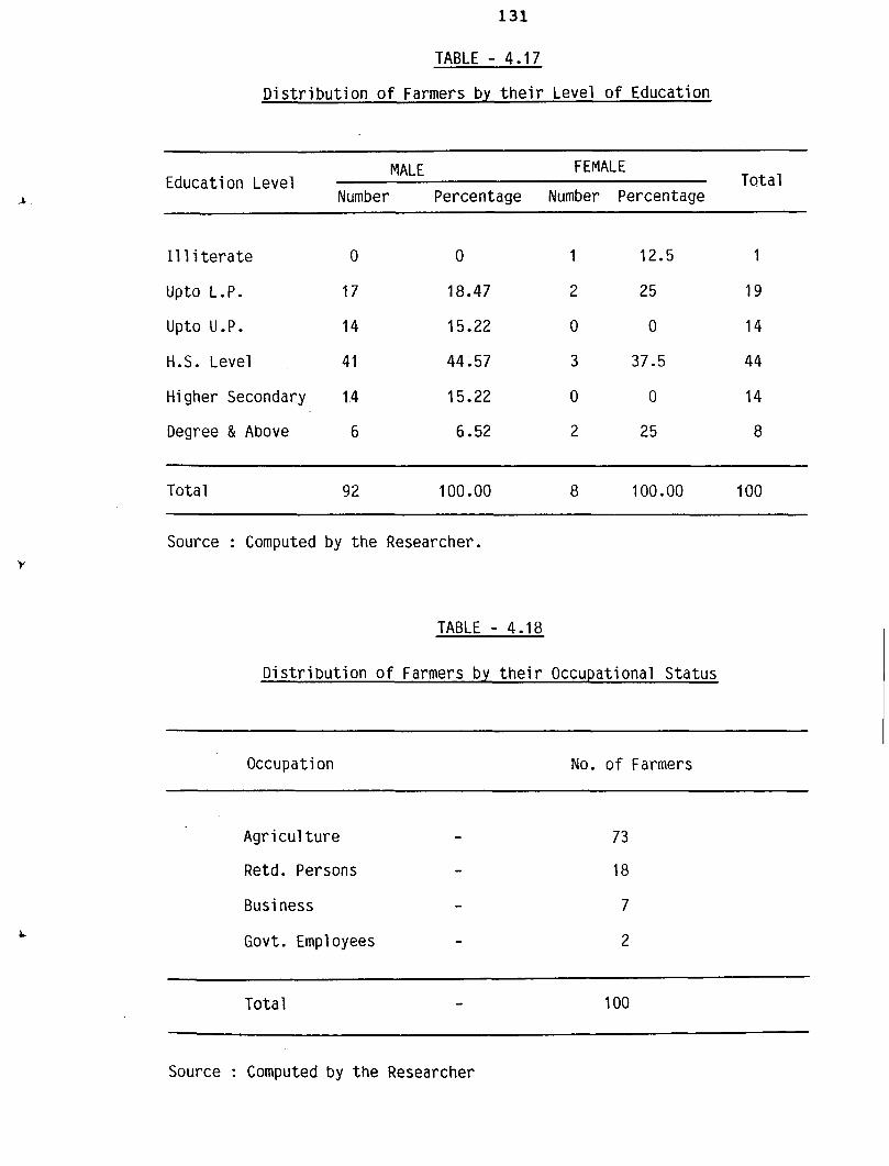
TABLE - 4.17
D i s t r i b u t i o n o f Farmers by t h e i r Level o f Education
MALE FEMALE Education Level Total
Number Percentage Number Percentage
I 1 l i t e r a t e 0 0 1 12.5 1
Upto L.P. 17 18.47 2 25 19
Upto U.P. 14 15.22 0 0 14
H.S. Level 4 1 44.57 3 37.5 44
Higher Secondary 1.4 15.22 0 0 14
Degree & Above 6 6.52 2 25 8
Total 92 100 .OO 8 100.00 100
Source : Computed by the Researcher.
TABLE - 4.18
D i s t r i b u t i o n o f Farmers by t h e i r Occupational Status
Occupation No. o f Farmers
Agri cul t u r e - Retd. Persons - Business - Govt. Employees -
Total - 100
Source : Computed by the Researcher
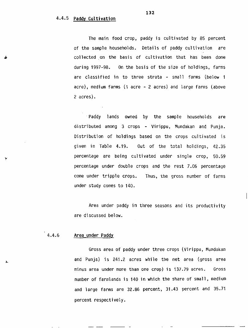
132 4.4 5 Paddy C u l t i v a t i o n
The main food c rop , paddy i S c u l t i v a t e d by 8 5 pe rcen t
of t h e sample households. D e t a i l s of paddy c u l t i v a t i o n are
c o l l e c t e d on t h e b a s i s of c u l t i v a t i o n t h a t has been done
during 1997-98. On t h e b a s i s of t h e s i z e o f ho ld ings , farms
a r e c l a s s i f i e d i n t o t h r e e s t r a t a - small farms (below 1
a c r e ) , medium farms ( 1 a c r e - 2 a c r e s ) and l a r g e farms (above
2 a c r e s ) .
P a d d y l ands owned by t h e sample households a r e
d i s t r i b u t e d among 3 crops - Virippu, Mundakan and Punja.
D i s t r i b u t i o n of holdings based on t h e c rops c u l t i v a t e d i s
given i n Table 4.19. O u t of t h e t o t a l ho ld ings , 42.35
percentage a r e being cu l t i vated under s i n g l e c rop , 50.59
percentage under double c rops and t h e rest 7.06 percentage
come under t r i p p l e c rops . Thus, t h e g ros s number of farms
under s tudy comes t o 140.
Area under paddy i n t h r e e seasons and i t s p roduc t iv i t y
a r e d i scussed be1 ow .
4.4.6 Area under Paddy
Gross a r e a of paddy under t h r e e c rops (Vi r i ppu, Mundakan
and Punja) i s 241.2 a c r e s while t h e net a r ea ( g r o s s a r e a
minus a r e a under more t han one c rop ) i S 137.79 ac re s . Gross
number o f farm1 ands i S 140 i n which t h e sha re of smal l , medi urn
and l a r g e farms a r e 32.86 pe rcen t , 31.43 percent and 35.71
percent r e s p e c t i v e l y .
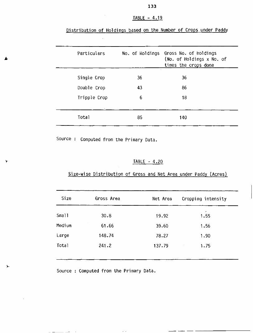
TABLE - 4.19
D i s t r i b u t i o n of Holdings based on t h e Number o f Crops under Paddy
P a r t i c u l a rs No. of Holdings Gross No. o f hold ings (No. o f Holdings X No. o f times the crops done
S ing le Crop 36 36
Double Crop 4 3 86
T r i pp le Crop 6 18
Tota l 8 5 140
Source : Computed from the Primary Data.
TABLE - 4.20
Size-wise D i s t r i b u t i o n o f Gross and Net Area under Paddy (Acres)
-- P p-
Size Gross Area Net Area Cropping i n t e n s i t y
Smal l 30.8
Medi urn 61.66
Large 148.74
Total 241.2
Source : Computed from t h e Primary Data.
Tab1 e 4.20 represents s i ze-wi se di stri bution of gross
and ne t area under paddy. Gross area of small , medium and
large farms. a r e 30.8 ac res , 61.66 acres and 148.74 ac res
respect ively with an average s i z e of 0.67, 1.47 and 2.97
acres i n each category. Also, t h e n e t area i s d i s t r i b u t e d
among small , medium and l a rge holdings with average s i z e
of holdings of 0.66, 1.41 and 2.89 acres respect ively .
Cropping i n t e n s i t y i s t h e h ighes t in l a rge holding category
(1.90) whereas i t i s 1.75 a l together . -
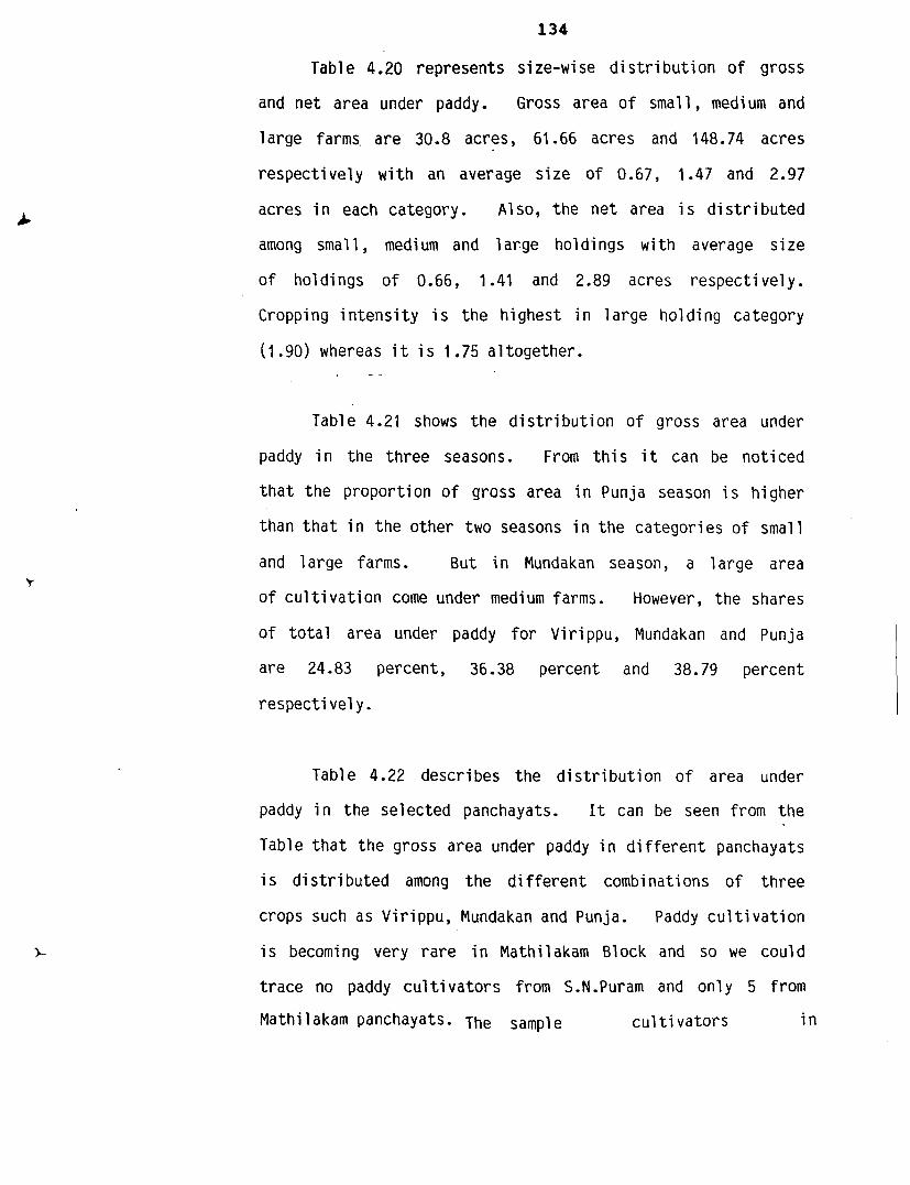
Table 4.21 shows t h e d i s t r i b u t i o n of gross area under
paddy i n the t h r e e seasons. From t h i s i t can be noticed
t h a t t h e proportion of gross area i n Punja season i S higher
than t h a t i n t h e other two seasons i n t h e ca tegor ies of smal l
and l a rge farms. B u t i n Mundakan season, a l a rge area
of c u l t i v a t i o n come under medium farms. However, the shares
of t o t a l area under paddy f o r Virippu, Mundakan and Punja
a r e 24.83 percent , 36.38 percent and 38.79 percent
respect i vel y .
Table 4.22 descr ibes t h e d i s t r i b u t i o n of area under
paddy i n the se lec ted panchayats. I t can be seen from t h e
Table t h a t t h e gross area under paddy i n d i f f e r e n t panchayats
i S d i s t r i b u t e d among t h e d i f f e r e n t combinations of t h r e e
crops such a s Virippu, Mundakan and Punja. Paddy c u l t i v a t i o n
i s becoming very r a r e i n Mathilakam Block and so we could
t r a c e no paddy c u l t i v a t o r s from S.N.Puram and only 5 from
Mathilakam panchayats. The sample c u l t i v a t o r s i n
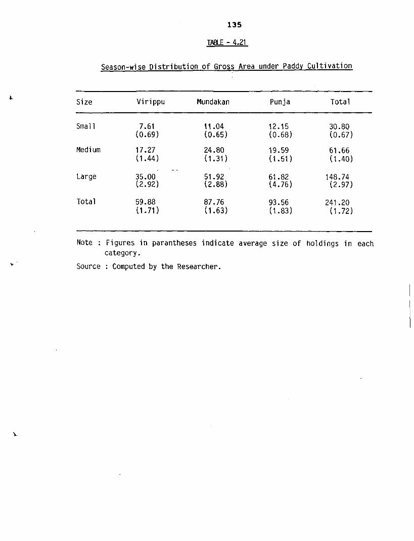
TABLE - 4.21
Season-wi se D i s t r i b u t i o n o f Gross Area under Padd.y Cul t i va t i on
S i z e Vi r i ppu Mundakan Punja Tota l
Smal l 7.61 (0.69)
Medi urn 17.27 (1.44)
Large
Total 59.88 (1.71)
Note : Figures i n paran theses i n d i c a t e average s i z e o f holdings i n each category.
Source : Computed by t h e Researcher.
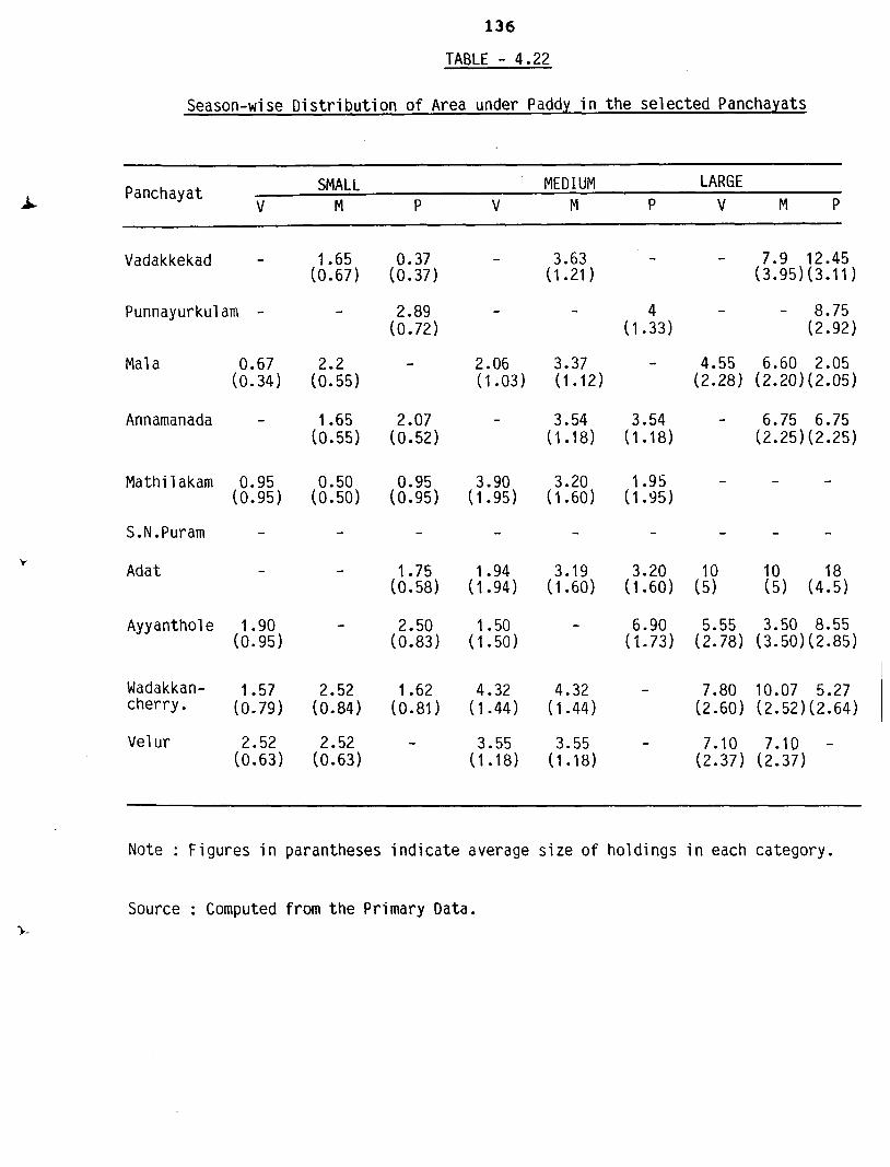
TABLE - 4.22
Season-wi se Distribution of Area under Paddy in the selected Panchayats
Panchayat SMALL MED I UN LARGE V M P V M P V M P
Vadakkekad - 1.65 (0.67)
Punnayurkul am - -
Mal a 0.67 2.2 (0.34) (0.55)
Annamanada - 1.65 (0.55)
Mathi l akam 0.95 0.50 (0.95) (0.50)
Ada t - -
Ayyanthol e 1 .90 - (0.95)
Wadakkan- 1.57 2.52 cherry. (0.79) (0.84)
Vel ur 2.52 2.52 (0.63) (0.63)
Note : Figures in parantheses indicate average size of holdings in each category.
Source : Computed from the Primary Data.
137
Vadakkekad and Annamanada Panchayats are not doi ng paddy
cu l ti vat ion i n V i r i ppu season whi l e those i n Vel u r Panchayat
are no t doing Punja Crop. Some o f the sample farms i n Mal a,
Adat, Ayyanthol e and Wadakkancherry Panchayats are c u l t i v a t e d
i n a1 l the th ree seasons. Also i t could be seen t h a t t he
average s ize o f smal l h01 d i ngs i S comparati vely la rger i n
Ayyanthol e and Wadakkanchery Panchayats (0.88 and 0.82 acres
respect i vel y ) and small e r i n Mal a Panchayat (0.48 acres).
A t the same time, the average area under medium holdings
i s higher i n Mathilakam (1.81 acres) and Adat (1.67 acres)
Panchayats and smaller i n Mala (1.09 acres) and Velur (1 . l 8
acres) Panchayats whereas t h a t under l arge farms i S higher
i n Vadakkekad and Adat Panchayats (above 3 acres).
4.4.7 Produc t i v i t y o f Paddy
It i S necessary t o determine the p roduc t i v i t y o f paddy
i n study area t o assess the s ta te o f paddy cu l t i va t i on .
Table 4.23 gives average p roduc t i v i t y o f paddy i n d i f f e r e n t
s ize categories i n d i f f e r e n t seasons. It could be not iced
from the Table t h a t p roduc t i v i t y i s r e l a t i v e l y higher i n
Punja Crop and it i s the highest among small farms.
Producti v i t y o f Mundakan crop i S comparati vel y higher i n
medium farms and t h a t o f V i r ippu i s higher i n la rge farms.
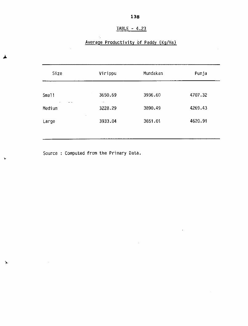
Table 4.24 shows the average p roduc t i v i t y o f paddy
i n the selected Panchayats w i t h respect t o the l a rge farms,
138
TABLE - 4.23
Average P r o d u c t i v i t y o f Paddy ( KgIHa)
Size V i r i ppu Mundakan Punja
Smal l 3650.69 3936.60 4707.32 - -
Med i um 3228.29 3890.49 4269.43
Large 3933.04 3651 .O1 4620.91
Source : Computed from t h e Primary Data.
TABLE 4.24
AVERAGE PRODUCTIVITY OF PADDY ( ~ g 1 ~ a ) ' - SIZEWISE AND SEASONWISE
P Source :Com;ted from the Primary Data.
PANCHAYAT
Vadakkekad
Punnayurkulam
Mala
Annamanada
Mathilakam
S.N.Puram
Ad at
Ayyanthole
Wadakkancherry
Velur
V
2939.83
2340.95
3706.50
3036.91
4612.53
M
5731.61
3058.09
3860.94
1482.60
3153.54
4612.53
V
31 15.26
1520.62
2292.68
3624.13
3460.58
4389.75
V
1836.98
4324.25
4263.98
5447.1 8
3334.85
SMALL,
P
6010.54
5708.26
4472.56
2601.05
4887.09
4616.87
3442.52
- .
M
891 3.25
'
3494.34
2490.61
1329.26
2692.63
3673.55
4554.48
AVERAGE
5871 - 0 8
5708.26
2998.96
41 66-75
2141 .S3
4887.09
41 61.69
321 (;. 99
461 2.53
M
6940.60
2262.07
2514.21
4324.25
3883.00
4924.45
3455.38
MEDIUM
P
5463.66 .
2569.06
1900.77
5485.6?
4633'13
AVERAGE
891 3.25
5463.66
3342.71
2529.84
583.55
3490.31
41 28.63
3567.07
4472.12
LARGE
P
4925.04
4008.51
2554.39
481 8.45
5530.33
6271.84
AVERAGE
5932.82
4008.51
2049.53
2534.30
4488.98
4559.10
5547 -82
3395.1 1
140
average productivi ty i s higher i n t h e panchayats of
Wadakkancherry and Ayyanthole.Vadakkekad panchayat s tands
top with an average productivi ty of 8913.25 Kg. per hectare
i n medium farms. Also t h e productivi ty of small farms i s
higher i n Vadakkekad and Punnayurkulam panchayats of Chavakkad
Block. Average productivi ty i s found t o be t h e lowest i n
Mathilakam Panchayat and i t may be one of t h e reasons f o r
t h e large s c a l e s h i f t i n g from paddy t o coconut c u l t i v a t i o n
i n t h i s block. - -
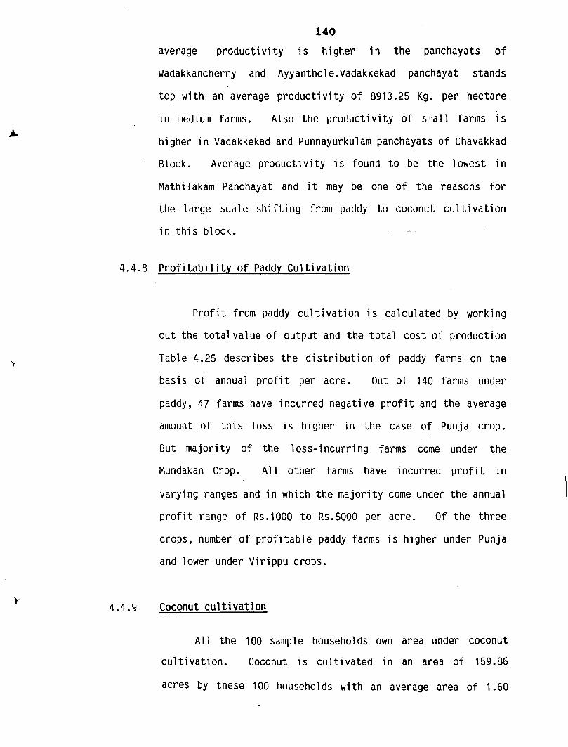
4.4.8 Prof i t ab i l i t y of Paddy Cul t i vati on
P r o f i t from paddy c u l t i v a t i o n i S ca lcula ted by working
out the t o t a l value of output and t h e t o t a l c o s t of production
Table 4.25 describes t h e d i s t r i b u t i o n of paddy farms on t h e
bas is of annual p r o f i t per acre. O u t of 140 farms under
paddy, 47 farms have incurred negative p r o f i t and t h e average
amount of t h i s l o s s is higher i n t h e case of Punja crop.
B u t majority of t h e loss-incurring farms come under t h e
Mundakan Crop. All o ther farms have incurred p r o f i t i n
varying ranges and i n which t h e majority come under t h e annual
p r o f i t range of Rs.1000 t o Rs.5000 per acre. Of t h e t h r e e
crops, number of p r o f i t a b l e paddy farms i S higher under Punja
and l ower under Vi r i ppu crops.
4.4.9 Coconutcu l t iva t ion
A1 l t h e 100 sample households own area under coconut
cu l t iva t ion . Coconut i s cu l t iva ted in an area of 159.86
acres by these 100 households with an average area of 1.60
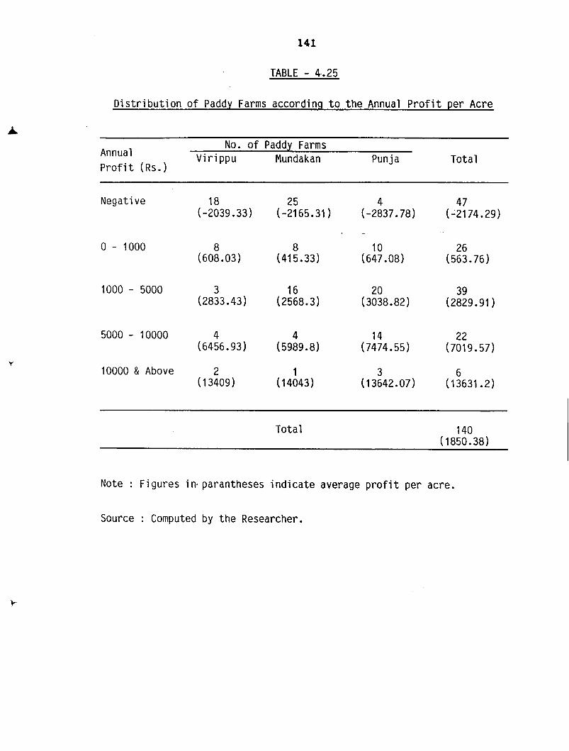
TABLE - 4,.25
Distr ibution of Paddy Farms according t o t he Annual P ro f i t per Acre
No. of Paddy Farms Annual Virippu Mundakan Punja Total P ro f i t (Rs.)
Negative 18 (-2039.33)
10000 & Above 2 ( 1 3409 )
Total 140 (1850.38)
Note : Figures i n parantheses i ndi c a t e average p r o f i t per acre.
Source : Computed by the Researcher.
TABLE - 4.26
Si ze-wi se D i stri bution of Area under Coconut C u l t i va t i on
No. of Farms Area (Acres) Percentage t o t o t a l area
Smal l
Medi um
Large . -
Total 100 159.86 100.00 (1.60)
Note : Figures i n Parantheses i n d i c a t e average s i z e of holdings.
Source : Computed from t h e Primary Data.
TABLE : 4.27
Size-wise Dis t r ibu t ion of Coconut Farms according t o the
Number of Actual Palms per Acre
No. of Palm1 Acre
No. of Farms Total
Smal l Medi um Large
25 - 50 3 2 '5 10
50 - 75 8 18 18 44
75 - 100 16 13 10 3 9
100 - 125 4 1 0 5
125 & above 2 0 0 2
Total 3 3 3 4 33 100
Note : Figures i n parantheses i n d i c a t e average No. of PalmsIAcre. Source : Computed from the Primary Data.
143
acres per household. O f t he t o t a l area, 17.36 acres come
under t he small size, 47.24 acres come under the medium s i ze
and 95.26 acres belongs t o the la rge s i ze w i t h an average
s i ze o f 0.54, 1.35 and 2.89 acres respect ive ly (Table 4.26).
Since the whole area under coconut i s no t covered by
coconut palms only, i t i s necessary t o assess the number
o f palms per acre under d i f f e r e n t s i ze o f holdings.
Table 4.27 represents s i ze-wi se d i s t r i bu t ion o f coconut farms
'according t o the' number o f adu l t palms per acre. It can
be seen t h a t 44 percentage o f the farms possess palms between
the range o f 50 t o 75 numbers per acre ou t o f which the shares
o f medium and la rge hold ings are the same (40.91% each) and
the remaining 18.18 percent come under the small holdings.
It i s t o be noted t h a t 50 percentage o f the 10 farms w i t h
the lowest i n t e n s i t y o f 25 t o 50 palms per acre come under
the category o f la rge holdings. Medium and la rge holdings
are no t e x i s t i n g i n the category o f the highest i n t e n s i t y
o f more than 125 palms per acre. Seasonwise f i gu res dep ic t
t h a t there i s an inverse r e l a t i onsh ip between the s i ze of
holdings and average number o f palms per acre.
4.4.10 Produc t i v i t y o f Coconut
Annual p roduc t i v i t y i s determined i n terms of nuts
per palm which i s described i n Table 4.28. Ma jo r i t y o f
the coconut farms (39 percent) come under the category o f
annual p roduc t i v t y o f 70 t o 100 nuts per palm w i t h m average
annual p roduc t i v i t y o f 83.68 nuts per palm and the small
holdings cons t i t u t e re1 a t i vel y higher share i n t h i S category.
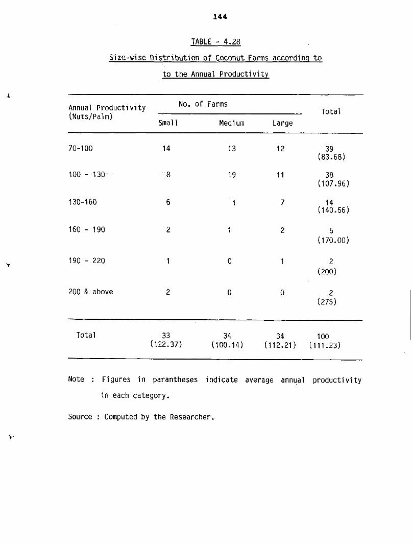
TABLE - 4.28
Si ze-wi se D i stri but ion of Coconut Farms according t o
t o t h e Annual P roduc t iv i t y
Annual Product i vi t y No. of Farms
(Nuts/Palm) Total
Smal l Medi um Large
200 & above 2
Total 33 3 4 34 100 (122.37) (100.14) (112.21) (111.23)
Note : Figures i n paran theses i n d i c a t e average annual product i vi t y
i n each ca tegory .
Source : Computed by t h e Researcher.
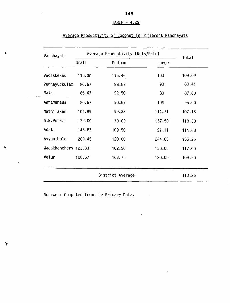
TABLE - 4.29
Averaqe P r o d u c t i v i t y o f Coconut i n D i f f e r e n t Panchayats
Panchayat Average Product i v i t y (NutsIPalm) Tota l
Smal l Medi um Large
Vadakkekad 11 5.00
Punnayurkul am 86.67
- - Mal a 86.67
Annamanada 86.67
Mathi l akam 104.89
Ayyanthol e 209.45
Wadakkanchery 123.33
Vel u r 106.67
D i s t r i c t Average
Source : Computed from t h e Primary Data.
146
Of t h e t o t a l farms, 38 percentage have a t t a i n e d an average
annual p roduc t iv i t y of 107.96 nuts per palm i n which t h e
sha re o f medium farms i s r e l a t i v e l y h igher than t h e o t h e r
two c a t e g o r i e s . A1 s o 4 percentage have an average o f above
200 n u t s per palm o u t o f which 75 percentage i s c o n s t i t u t e d
by t h e small farms and t h e remaining 25 percentage by t h e
medium farms. Seasonwise average annual p roduc t iv i t y r e v e a l s
t h a t i t i s t h e h ighes t i n small ho ld ings and t h e lowest i n
medi um h01 di ngs.
Tab1 e 4.29 shows var i a t i o n s i n average product i vi t y
of coconut i n d i f f e r e n t panchayats. Average product i vi t y
i S t h e h i g h e s t i n Ayyanthol e Panchayat (1 56.26 nuts /palm)
while i t i s t h e lowest i n Mala Panchayat (87 nuts lpa lm) .
With r e s p e c t t o t h e s i z e of h01 di ngs, average product i vi t y
of small and medium farms i s r e l a t i v e l y h igher i n Vadakkekad,
Mala and Adat Panchayats.
4.4.11 Prof i t a b i l i t y of Coconut Cul t i v a t i on
Annual P r o f i t from coconut c u l t i v a t i o n i S c a l c u l a t e d
on t h e b a s i s of t o t a l value of ou tput and t o t a l c o s t of
c u l t i v a t o n . Table 4.30 r e v e a l s t h a t only one of t h e 100
households has incur red an average l o s s of Rs.197 per palm
and 51 pe rcen t of t h e c u l t i v a t o r s have a t t a i n e d an average
annual p r o f i t o f Rs.423.09 per palm. I t can a l s o be no t i ced
t h a t about 7 percent have incur red an average annual p r o f i t
o f Rs.900 per palm.
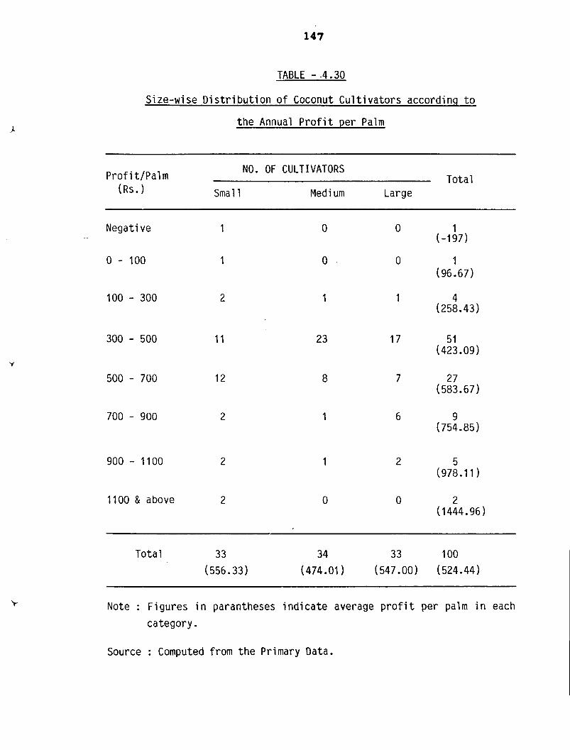
TABLE - .4.30
Size-wise D i s t r i b u t i o n o f Coconut C u l t i v a t o r s according t o
t h e Annual P r o f i t per Palm
NO. OF CULTIVATORS Pro f i t /Pa l m
(Rs.1 Sma l l Medi urn Large
Negative 1
0 - 100 1
100 - 300 2
900 - 1100 2
1100 & above 2
Tota l 3 3 34 33 100
(556.33) (474.01) (547.00) (524.44)
Note : Figures i n parantheses i n d i c a t e average p r o f i t per palm i n each
category.
Source : Computed from t h e Primary Data.
4.4.12 Income Distribution of Sample Households
Annual income of the sample households i s calculated
by working out the i r to ta l farm income and income from other
sources. Table 4.31 shows the income distribution of sample
households. Majority of the households (67 percent) depend
on wage income other t h a n the farm income. The r e s t of
the 33 percent of households ful ly depend on the farm income
in which 48.48 percent of them have g o t an annual income
in the range of Rupees 50,000 - 1,50,000. Thus the household
excl usi vel y depending on agriculture are earning re1 a t i vel y
higher income. Besides 39 percentage of the households
are getting more than 50 percentage of the i r income from
cultivation. Also i t can be seen tha t 23 percentage of
the to ta l sample households have an annual family income
between Rs.10,000 and Rs.50,000.
4.4.13 Conclusion
Paddy and coconut are the main crops cultivated in the
sample area and also by the sample households. Paddy i s
cultivated among three crops (Vi r i ppu, Mundakan and Punja)
in which the proportion of gross area in Punja season i s
higher (38.79 percent) t h a n tha t in the other two seasons.
Also the productivity of paddy in Punja crop i s relat ively
higher and i t i S the highest among small farms (4707.32 Kg/
hectare). 33.57 percent of the sample farms have incurred
loss in paddy cultivation and majority of the loss incurring
TABLE - 4.31
D i s t r i bu t i on of Sample Households according t o t h e i r Annual Income
Source : Computed by the Researcher.
No. of sample Households
1 0000- 25000- 50000- 1 00000- 1 50000- Above Total 25000 50000 100000 150000 200000 200000
/
1 000-5000
5000-10000
10000-25000
25000-50000
50000-1 00000
1 00000- 1 5000C
150000-2OOOOt
above 200000 l
1 - 1 1 - - 2
- - - - 1 1
6 6 3 1 - - 16
- 10 13 4 - 1 28
- - 22 7 5 1 35
- - - 8 1 3 12
- - - - 2 2 4
- . - - - . - 2 2
farms come under the Mundakan.crop. The remaining 66.43
percent have incur red p r o f i t i n the range o f Rs.1000 - 5000
per acre. I n the case o f coconut, densi ty o f c u l t i v a t i o n
i s i n t he range o f 25 - 150 palms per acre i n which ma jo r i t y
of the farms come under the density range o f 50 - 100 palms
per acre. The annual p roduc t i v i t y o f coconut i n ma jo r i t y
o f the farms (77 percent) i s between 70 and 130 nuts per
palm. Compared t o paddy cu l ti va t i on, p ro f i t a b i l i t y o f
coconut i s h igh and thus most o f the sample c u l t i v a t o r s
compensate t h e i r loss o r low p r o f i t i n paddy c u l t i v a t i o n
through coconut cu l t i va t i on .