Embed Size (px)
Citation preview
8
Sample Question Paper-IGEOGRAPHY (Theory)
CLASS XII
Time : 3 hrs. Max. Marks : 70
General Instructions:
1. There are 26 questions in all.
2. All questions are compulsory.
3. Marks for each question are indicated against it.
4. Question numbers 1 to 10 are very short answer questions carrying 1 mark each.Answer to each of these questions should not exceed 20 words.
5. Question numbers 11 to 20 are short answer questions carrying 3 marks each. An-swer to each of these questions should not exceed 80 words.
6. Question numbers 21 to 25 are long answer questions of 5 marks each.Answer to each of these questions should not exceed 150 words.
7. Question no. 26 is related to identification or locating and labelling of geographicalfeatures on maps.
8. Outline maps of the World and India provided to you must be attached within youranswer book.
9. Use of templates or stencils for drawing outline maps is allowed.
Q 1. What is the population size of Class I cities in India? 1
Q 2. Name the two categories of air transport in India. 1
Q 3. Name the headquarters of Northern Railway Zone of India. 1
Q 4. Name the stretch of National Waterway No. 1 of India. 1
Q 5. Which type of pollution causes various diseases related to the respiratory system? 1
Q 6. Give one example each of ferrous and non-ferrous industries. 1
Q 7. Explain the term Quinary Activities. 1
Q 8. Which means of transport is highly suitable for transporting heavy and bulky goodsat very low cost over long distances between continents. 1
Q 9. Explain the most important feature of the pipeline constructed from Naharkatia oilfield to Barauni. 1
9
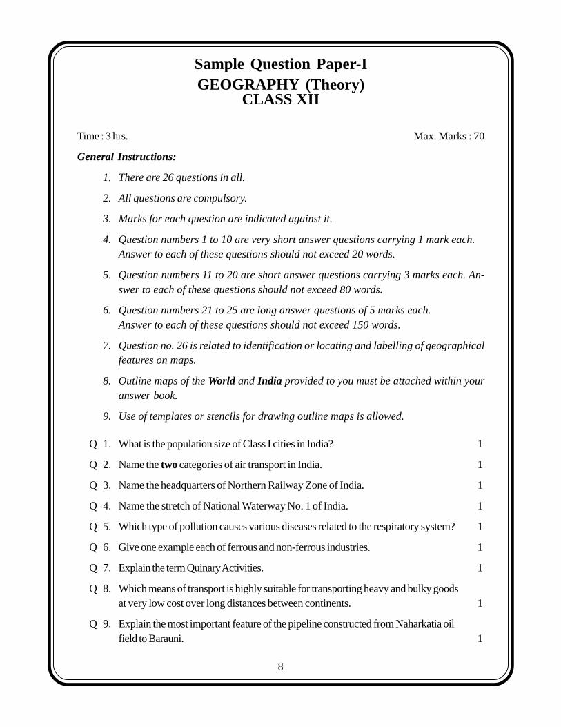
Q 10. Which one of the following waterways has drastically reduced the oceanic distance betweenIndia & Europe:- (i) The Rhine waterway; (ii) The Cape of Good Hope Searoute;(iii) Suez Canal and (iv) Panama canal. 1
Q 11. Make the correct pairs of each item of List I by selecting the appropriate word from List II
List I : Fields of Human Geography
1.1 Social Geography, 1.2 Political Geography and 1.3 Economic Geopraphy
List II : Disciplines of Social Science
A. Urban Studies and Planning, B. Agricultural Sciences, C. Demography, D. History andE. Military Science. 3x1=3
Q 12. State any three characteristics of clustered rural settlements in India. 3x1=3
Q 13. Describe three major problems associated with urban waste disposal in India. 3x1=3
Q 14. Distinguish between the Dryland farming and Wetland farming in India by explainingthree distinguishing features of each. 3x1=3
Q 15. Explain the meaning of water quality. Why is the quality of water in India deteriorating?Give any two reasons. 1+2=3
Q 16. Explain any three important measures initiated under the new Industrial Policy of Indiaannounced in 1991. 3x1=3
Q 17.
(17.1) Name the transcontinental railway line shown in the above map.
(17.2) How has this railway line helped in the economic development of the region? Explain twopoints. 1+2=3
For Blind Candidates only in lieu of Question 17
(17.1) Name the Trans Continental railway of Canada.
(17.2) Explain any two points regarding the economic importance of this railway line for the country.1+2=3
10
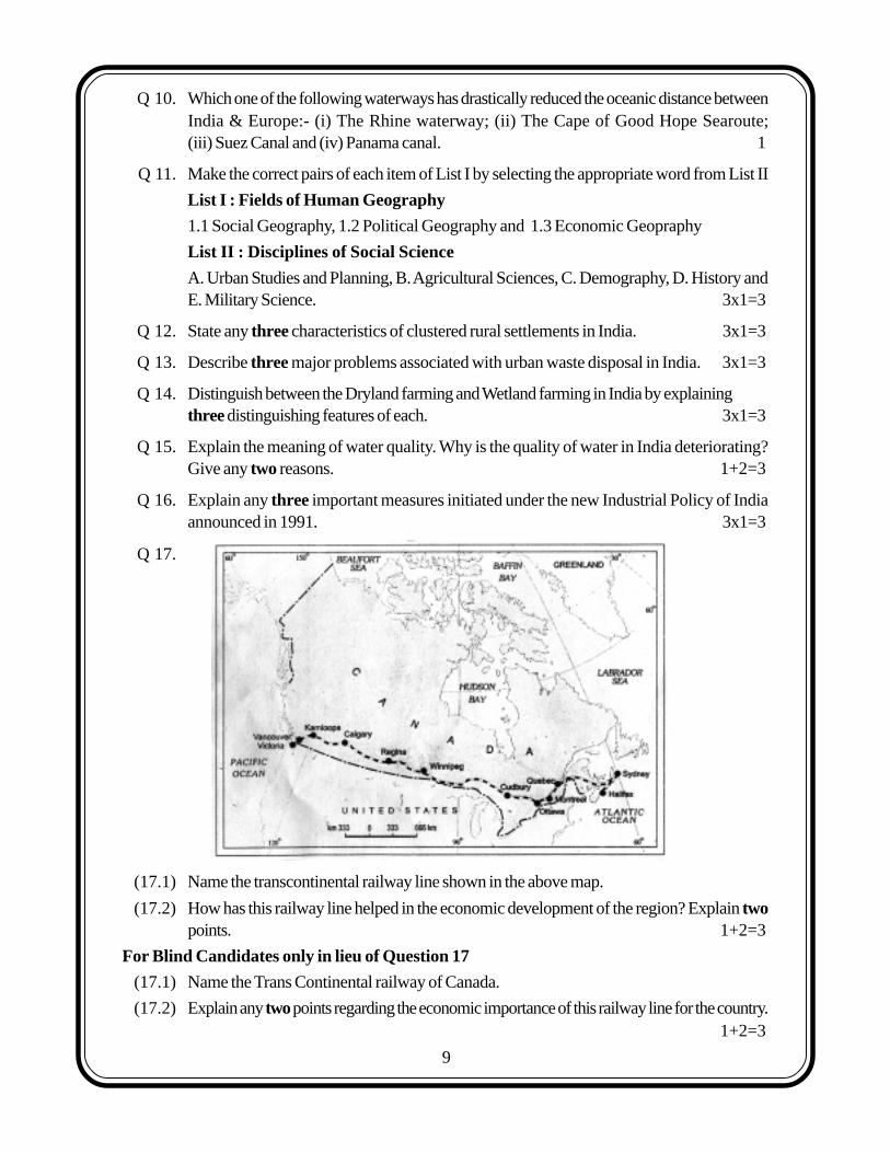
Q 18. Study the given table and answer the following questions.
Percentage of net irrigated area to total by wells and tube-wells
State Percentage
Gujarat 86.6
Rajasthan 77.2
Madhya Pradesh 66.5
Maharashtra 65
Uttar Pradesh 58.21
West Bengal 57.16
Tamil Nadu 54.7
(18.1) Name the state which has the highest percentage of irrigated area by wells & tube-wells.Also give the reason for the same.
(18.2) Which state has the lowest percentage of area irrigated by wells and tube-wells? Also givethe main reasons for the same. 1½+1½=3
Q 19. Study the given map showing areas of extensive commercial grain farming in the world.Write in your answer book the correct names of grasslands associated with commericalGrain Farming in areas A, B and C marked in the map. 1+1+1=3
11
For Blind Candidates only in lieu of question No. 19
Name the grasslands assoicated with commerical grain farming in North America, Africaand Australia 3x1=3
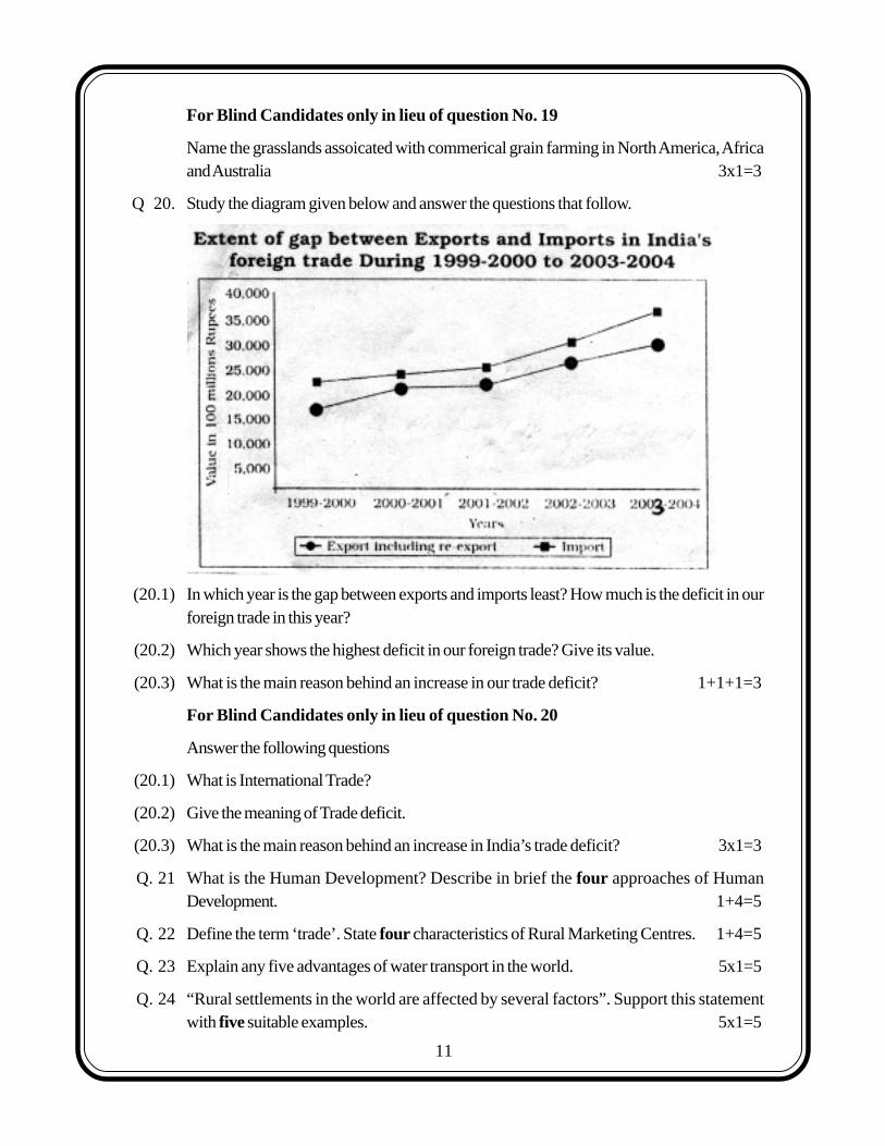
Q 20. Study the diagram given below and answer the questions that follow.
(20.1) In which year is the gap between exports and imports least? How much is the deficit in ourforeign trade in this year?
(20.2) Which year shows the highest deficit in our foreign trade? Give its value.
(20.3) What is the main reason behind an increase in our trade deficit? 1+1+1=3
For Blind Candidates only in lieu of question No. 20
Answer the following questions
(20.1) What is International Trade?
(20.2) Give the meaning of Trade deficit.
(20.3) What is the main reason behind an increase in India’s trade deficit? 3x1=3
Q. 21 What is the Human Development? Describe in brief the four approaches of HumanDevelopment. 1+4=5
Q. 22 Define the term ‘trade’. State four characteristics of Rural Marketing Centres. 1+4=5
Q. 23 Explain any five advantages of water transport in the world. 5x1=5
Q. 24 “Rural settlements in the world are affected by several factors”. Support this statementwith five suitable examples. 5x1=5
12
Q.25 Explain any five economic consequences associated with migration in India. 5x1=5
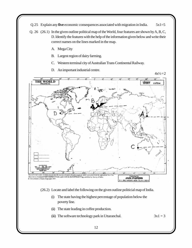
Q. 26 (26.1) In the given outline political map of the World, four features are shown by A, B, C,D. Identify the features with the help of the information given below and write theircorrect names on the lines marked in the map.
A. Mega City
B. Largest region of dairy farming.
C. Western terminal city of Australian Trans Continental Railway.
D. An important industrial centre.
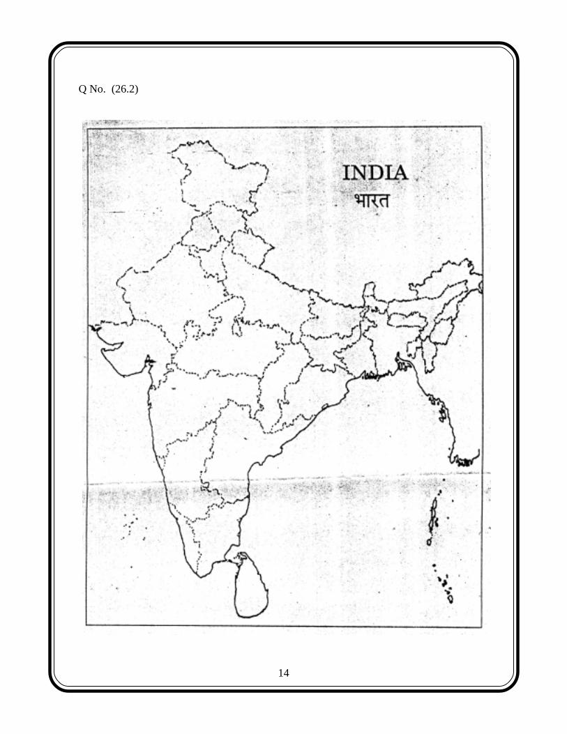
(26.2) Locate and label the following on the given outline politicial map of India.
(i) The state having the highest percentage of population below thepoverty line.
(ii) The state leading in coffee production.
(iii) The software technology park in Uttaranchal. 3x1 = 3
4x½=2
13
For Blind Candiates only in lieu of question 26
Answer the following questions :
(1) Name the western terminal station of Australian Trans Continental Railway.
(2) Name any one Mega city of Japan
(3) A state in India having the highest percentage of population below the poverty line.
(4) A state in India leading in coffee production.
(5) The software technology park in Uttaranchal.
5x1=5
14
Q No. (26.2)
15
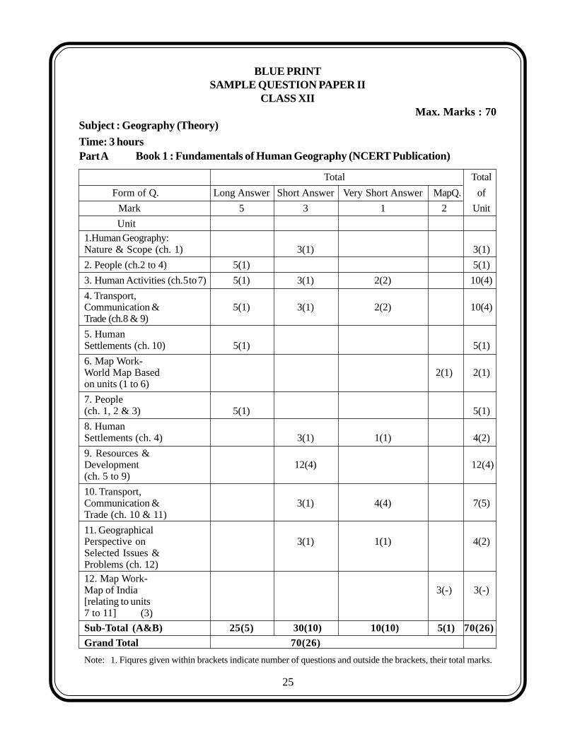
BLUE PRINTSAMPLE QUESTION PAPER II
CLASS XIIMax. Marks : 70
Subject : Geography (Theory)
Book 1 : Fundamentals of Human Geography (NCERT Publication)
Total Total
Form of Q. Long Answer Short Answer Very Short Answer MapQ. of
Mark 5 3 1 2 Unit
Unit1.Human Geography:Nature & Scope (ch. 1) 3(1) 3(1)
2. People (ch.2 to 4) 5(1) 5(1)
3. Human Activities (ch.5to7) 5(1) 3(1) 2(2) 10(4)
4. Transport,Communication & 5(1) 3(1) 2(2) 10(4)Trade (ch.8 & 9)
5. HumanSettlements (ch. 10) 5(1) 5(1)
6. Map Work-World Map Based 2(1) 2(1)on units (1 to 6)
7. People(ch. 1, 2 & 3) 5(1) 5(1)
8. HumanSettlements (ch. 4) 3(1) 1(1) 4(2)
9. Resources &Development 12(4) 12(4)(ch. 5 to 9)
10. Transport,Communication & 3(1) 4(4) 7(5)Trade (ch. 10 & 11)
11. GeographicalPerspective on 3(1) 1(1) 4(2)Selected Issues &Problems (ch. 12)12. Map Work-Map of India 3(-) 3(-)[relating to units7 to 11] (3)
Sub-Total (A&B) 25(5) 30(10) 10(10) 5(1) 70(26)
Grand Total 70(26)
Note: 1. Fiqures given within brackets indicate number of questions and outside the brackets, their total marks.
Part ATime: 3 hours
25
16
1. There are 26 questions in all.
2. All questions are compulsory.
3. Marks for each question are indicated against it.
4. Question numbers 1 to 10 are very short answer questions carrying 1 mark each.Answer to each of these questions should not exceed 20 words.
5. Question numbers 11 to 20 are short answer questions carrying 3 marks each. An-swer to each of these questions should not exceed 80 words.
6. Question numbers 21 to 25 are long answer questions of 5 marks each.Answer to each of these questions should not exceed 150 words.
7. Question no. 26 is related to identification or locating and labelling of geographicalfeatures on maps.
8. Outline maps of the World and India provided to you must be attached within youranswer book.
9. Use of templates or stencils for drawing outline maps is allowed.
Q 1. What term is used for a railway line that runs across a continent and linksits two ends? 1
Q 2. Name the famous petroleum pipeline which connects the oil wells of the Gulf of Mexico tothe North-Eastern States in USA. 1
Q 3. Name the air service of India which connects all the continents. 1
Q 4. Explain the term truck farming. 1
Q 5. Name the type of industry which has the following characteristics: assembly-linetechnique of mass production, advanced technology, use of various raw materials andenormous energy. 1
Q 6. Which type of rural settlement in India includes Panna, Para, Palli, Nagla, Dhani etc. 1
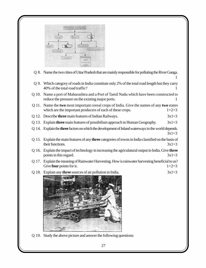
Q 7. Complete the following table by writing in your answer book the appropriate names ofitem No. 1 & 2 1
Sample Question Paper-IIGEOGRAPHY (Theory)
CLASS XII
Time : 3 hrs. Max. Marks : 70
General Instructions:
26
17
Q 8. Name the two cities of Uttar Pradesh that are mainly responsible for polluting the River Ganga.1
Q 9. Which category of roads in India constitute only 2% of the total road length but they carry40% of the total road traffic? 1
Q 10. Name a port of Maharashtra and a Port of Tamil Nadu which have been constructed toreduce the pressure on the existing major ports. 1
Q 11. Name the two most important cereal crops of India. Give the names of any two stateswhich are the important producers of each of these crops. 1+2=3
Q 12. Describe three main features of Indian Railways. 3x1=3
Q 13. Explain three main features of possibilism approach in Human Geography. 3x1=3
Q 14. Explain the three factors on which the development of Inland waterways in the world depends.3x1=3
Q 15. Explain the main features of any three categories of towns in India classified on the basis oftheir functions. 3x1=3
Q 16. Explain the impact of technology in increasing the agriculatural output in India. Give threepoints in this regard. 3x1=3
Q 17. Explain the meaning of Rainwater Harvesting. How is rainwater harvesting beneficial to us?Give four points for it. 1+2=3
Q 18. Explain any three sources of air pollution in India. 3x1=3
Q 19. Study the above picture and answer the following questions:
27
18
(19.1) Give a suitable title to the given picture.
(19.2) State two typical features of the service shown in the picture. 1+2=3
For Blind Candidates only, in lieu of question 19
(19.1) Name the service which provides food to office goers in Mumbai.
(19.2) Explain two main features of this service. 1+2=3
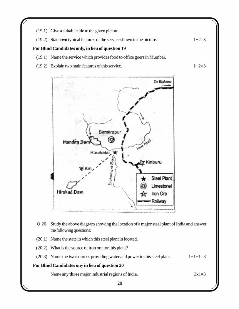
Q 20. Study the above diagram showing the location of a major steel plant of India and answerthe following questions:
(20.1) Name the state in which this steel plant in located.
(20.2) What is the source of iron ore for this plant?
(20.3) Name the two sources providing water and power to this steel plant. 1+1+1=3
For Blind Candidates ony in lieu of question 20
Name any three major industrial regions of India. 3x1=3
28
19
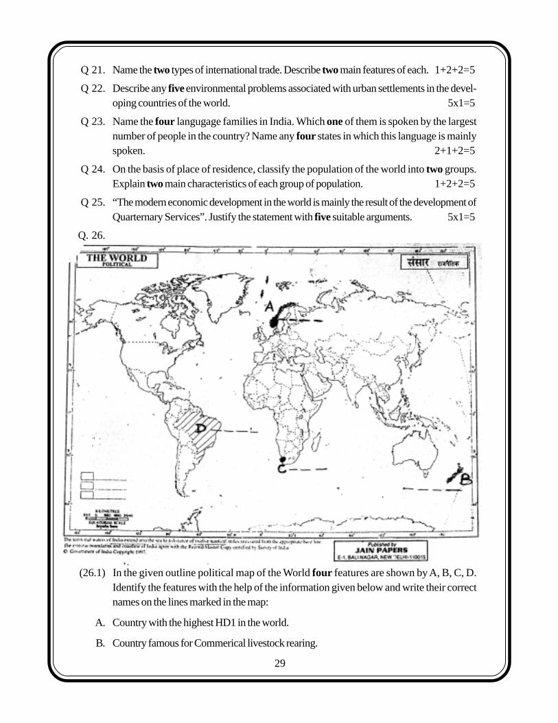
Q 21. Name the two types of international trade. Describe two main features of each. 1+2+2=5
Q 22. Describe any five environmental problems associated with urban settlements in the devel-oping countries of the world. 5x1=5
Q 23. Name the four langugage families in India. Which one of them is spoken by the largestnumber of people in the country? Name any four states in which this language is mainlyspoken. 2+1+2=5
Q 24. On the basis of place of residence, classify the population of the world into two groups.Explain two main characteristics of each group of population. 1+2+2=5
Q 25. “The modern economic development in the world is mainly the result of the development ofQuarternary Services”. Justify the statement with five suitable arguments. 5x1=5
Q. 26.
(26.1) In the given outline political map of the World four features are shown by A, B, C, D.Identify the features with the help of the information given below and write their correctnames on the lines marked in the map:
A. Country with the highest HD1 in the world.
B. Country famous for Commerical livestock rearing.
29
20
C. A major sea port.
D. Country famous for coffee plantations. 4x½=2
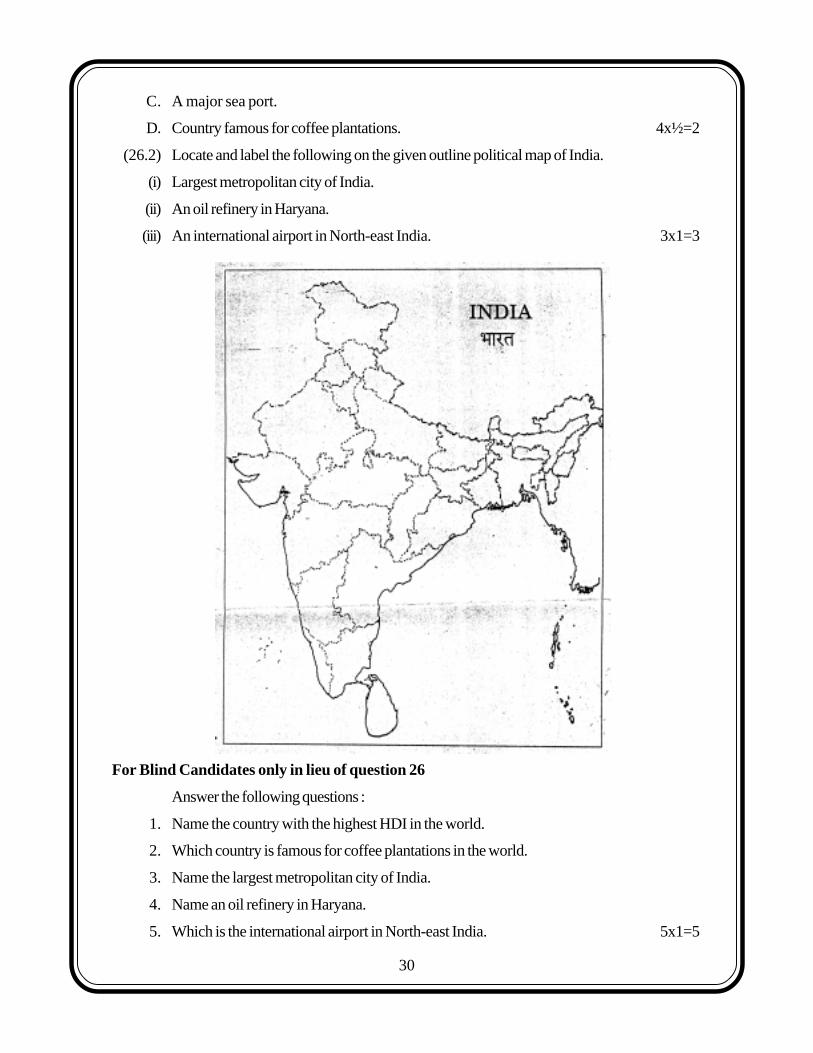
(26.2) Locate and label the following on the given outline political map of India.
(i) Largest metropolitan city of India.
(ii) An oil refinery in Haryana.
(iii) An international airport in North-east India. 3x1=3
For Blind Candidates only in lieu of question 26
Answer the following questions :
1. Name the country with the highest HDI in the world.
2. Which country is famous for coffee plantations in the world.
3. Name the largest metropolitan city of India.
4. Name an oil refinery in Haryana.
5. Which is the international airport in North-east India. 5x1=5
30