Embed Size (px)
Citation preview
S A N A N T O N I O I N T E R N A T I O N A L A I R P O R T V I C I N I T Y L A N D U S E P L A N
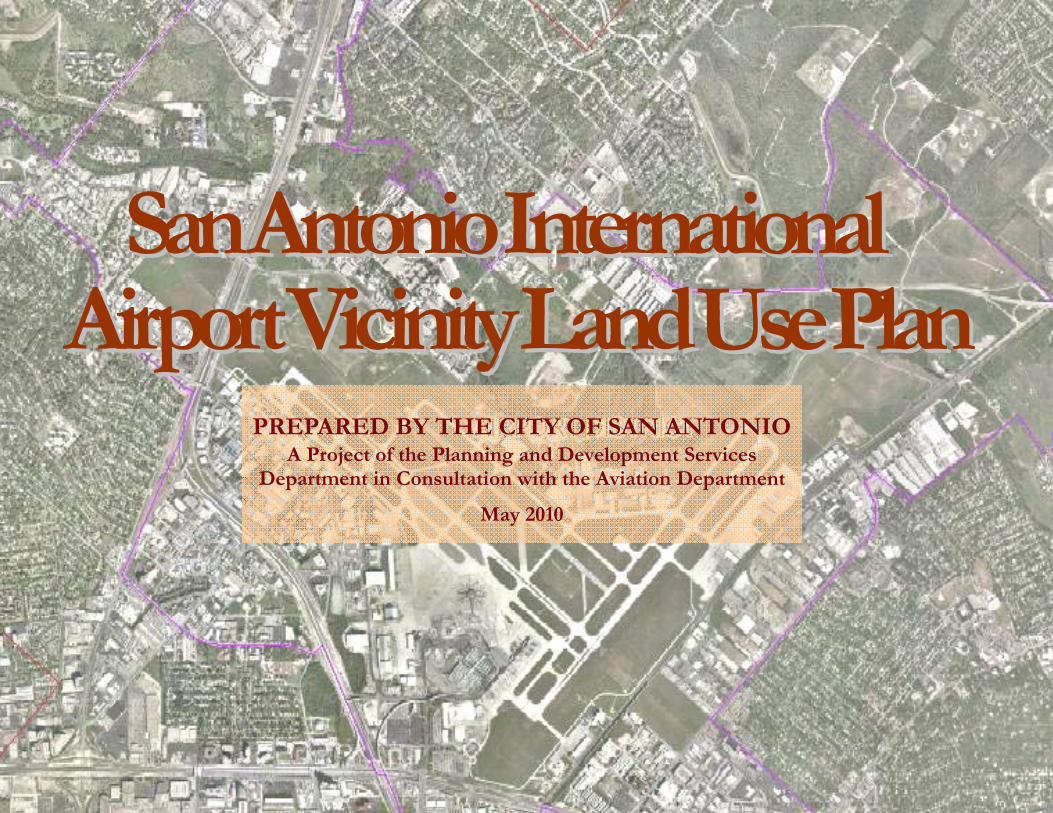
SSaann AAnnttoonniioo IInntteerrnnaattiioonnaall AAiirrppoorrtt VViicciinniittyy LLaanndd UUssee PPllaann
PREPARED BY THE CITY OF SAN ANTONIO A Project of the Planning and Development Services
Department in Consultation with the Aviation Department
May 2010
S A N A N T O N I O I N T E R N A T I O N A L A I R P O R T V I C I N I T Y L A N D U S E P L A N
i
Acknowledgements City of San Antonio City Council
Julián Castro, Mayor
Mary Alice P. Cisneros, District 1
Ivy R. Taylor, District 2
Jennifer V. Ramos, District 3
Philip A. Cortez, District 4
David Medina, Jr., District 5
Ray Lopez, District 6
Justin Rodriguez, District 7
W. Reed Williams, District 8
Elisa Chan, District 9
John G. Clamp, District 10
San Antonio Planning Commission
Amy Hartman, Chair
Jose R. Limon, Vice Char
Andrea Rodriguez, Chair Pro Tem
Rolando H. Briones, Jr.
Dr. Sherry Chao-Hrenek
Jody Sherrill
Christopher Lindhorst
Lynda Billa Burke
Marcello Diego Martinez
Public Meetings & Stakeholder Workshops
February 18, 2004, Blessed Sacrament Catholic Church
February 19, 2004, Northwood Elementary School
March 26, 2004, Development & Business Services Center
January 25 & February 3, 2010, Tool Yard
January 28, 2010, Eisenhauer Rd. Baptist Church
February 1, 2010, Jewish Community Center
S A N A N T O N I O I N T E R N A T I O N A L A I R P O R T V I C I N I T Y L A N D U S E P L A N
i
Aviation Department
Frank Miller, Director
Tim O’Krongley, Assistant Director
Steve Southers, Environmental Manager
Bill Telford, Noise Mitigation Planner
Jerry Rankin, former Noise Mitigation staff
Planning & Development Services Department
Roderick Sanchez, AICP, CBO, Director
Patrick Howard, AICP, Assistant Director
Nina Nixon-Mendez, AICP, Former Planning Manager
Andrea Gilles, Acting Planning Manager
Trish Wallace, AICP, Planning Manager
Christopher Looney, AICP, Planning Manager
Andrew Spurgin, AICP, Planning Manager
John Osten, Project Manager
Brad Smilgin, Project Planner
Gary Edenburn, Project Planner
Sidra Maldonado, Project Planner
International and Economic Development Department
A.J. Rodriguez, Interim Director
Ed Davis, Assistant Director
Public Works Department
Christina de la Cruz, P.E.
Capital Improvement Management Services
John Wolters
City Attorney’s Office
Susan Guinn
Airport Advisory Commission
Loren Wood, Chairman
Consultants
Llewelyn-Davies Sahni in association with
Ricondo & Associates
Bain Medina Bain
Ximenes & Associates
Sweet Promotions

S A N A N T O N I O I N T E R N A T I O N A L A I R P O R T V I C I N I T Y L A N D U S E P L A N
ii
Table of Contents
A C K N O W L E D G E M E N T S I
T A B L E O F C O N T E N T S 3
P L A N O V E R V I E W Purpose 4 Planning Area Characteristics 5 Planning Process 7 Plan Summary 8
C U R R E N T L A N D U S E Current Land Use 9 Plan Area Districts 12 C O M P A T I B I L I T Y G U I D E L I N E S 24 L A N D U S E P L A N 28
C O M P A T I B I L I T Y & R E D E V E L O P M E N T Current Strategies 41 Goals and Objectives 43 Compatibility/Redevelopment Plan 44
I M P L E M E N T A T I O N Implementation Plan 50 Goals, Objectives, Action Steps 51
M A P S Noise Exposure Map 27 Airport Districts Boundary Map 11 Existing Land Use Map 23 Future Land Use Plan Maps 35
T A B L E S Land Use Compatibility with DNL Levels 25 Land Use Categories/Zoning Matrix 29 Implementation Plan Action Steps 51
A P P E N D I C E S Area Demographics 57 Neighborhoods 59 Planning Commission Resolution 61 City Council Ordinance 62
S A N A N T O N I O I N T E R N A T I O N A L A I R P O R T V I C I N I T Y L A N D U S E P L A N
4
Plan Overview Purpose
Airport and community land use planning are intertwined to establish common goals for the development of compatible land use. The main concerns of airport land use are:
• Enhancing aircraft safety by protecting navigable air space around airports through height restrictions
• Ensuring safety of persons on the ground by reducing risks from aircraft operations and accidents
• Minimizing the effect of aircraft noise on adjacent neighborhoods
• Balancing land development within traffic patterns of the airport
In 2004, the City of San Antonio initiated a land use study to identify current land use issues and future strategies for the San Antonio International Airport (SAIT) area. The initial study conducted by Llewelyn-Davies Sahni was supplemented with an analysis by an interdepartmental technical committee made
up of members of the Aviation Department and Planning and Development Services Department in 2006-2008.
The purpose of the study was to understand current land use issues associated with the airport and adjacent areas, develop a land use plan, and recommend additional implementation strategies and incentives. The land use planning of this area will result in policies and regulations that reduce the public’s exposure to safety hazards and aircraft noise, provide for safer aircraft operations, and will help protect the airport and the corresponding public investment from the encroachment of incompatible land uses. Secondly, planning will promote compatible land uses beneficial to the area’s neighborhoods, economic development and environmental resources.
The land use plan identifies the preferred development for the area. The land use plan also provides strategies concerning urban design to provide an attractive experience for residents and airport patrons alike.
Key land use themes include protecting airport operations and expansion, discouraging residential development within noise contours, promoting business park and airfront uses directly adjacent to the airport, diversifying commercial uses along the corridors, promoting mixed-use and transit oriented development at key nodes, and preventing commercial encroachment into residential areas.
Two existing regulatory and procedural tools utilized today in the San Antonio International Airport vicinity are the Airport Hazard Zoning District and the Airport Awareness Zone. The Airport Hazard Overlay District limits the height of structures or natural growth that obstructs airspace required for take off, landing and flight of aircraft (FAA Regulation 14 CFR Part 77).
Plan Overview
S A N A N T O N I O I N T E R N A T I O N A L A I R P O R T V I C I N I T Y L A N D U S E P L A N
5
The Airport Awareness Zone was established in 2001 to ensure compatible uses around the airport, and requires consultation with Aviation Department staff for zoning change requests within the zone.
The adoption of a land use plan will ensure that future rezonings in the area of influence are consistent with the goals of the San Antonio International Airport vicinity. Additional strategies are also recommended to ensure compatible land uses adjacent to the airport. As airport operations continue to expand, a noise attenuation overlay district may be warranted in the future. Notations on plats, restrictive covenants, and property acquisition can also protect airport operations. A corridor overlay district could enhance the area’s urban design through additional development and design standards.
Planning Area Characteristics
The planning area is approximately 45.5 square miles and is generally bound by Huebner, Bitters, Jones Maltsberger, and Loop 1604 on the north, O’Connor, Bulverde, Nacogdoches and IH 35 on the east, Fort Sam Houston, Harry Wurzbach, Loop 410, Broadway, Alamo Heights city limits, US 281 and Loop 410 on the south, and Lockhill-Selma, and NW Military Hwy on the west. This boundary was based on Chapter 241 of the Local Government Code that grants political subdivisions, including cities, the authority to control and regulate land use in an area extending 1.5 miles out from the centerline of the runway and 5 miles out from the end of the runway.
The population of the planning area is 151,021 according to the 2008 estimate based on Claritas data. It is comprised of
26 Census Tracts. The population characteristics are summarized in the Appendix.
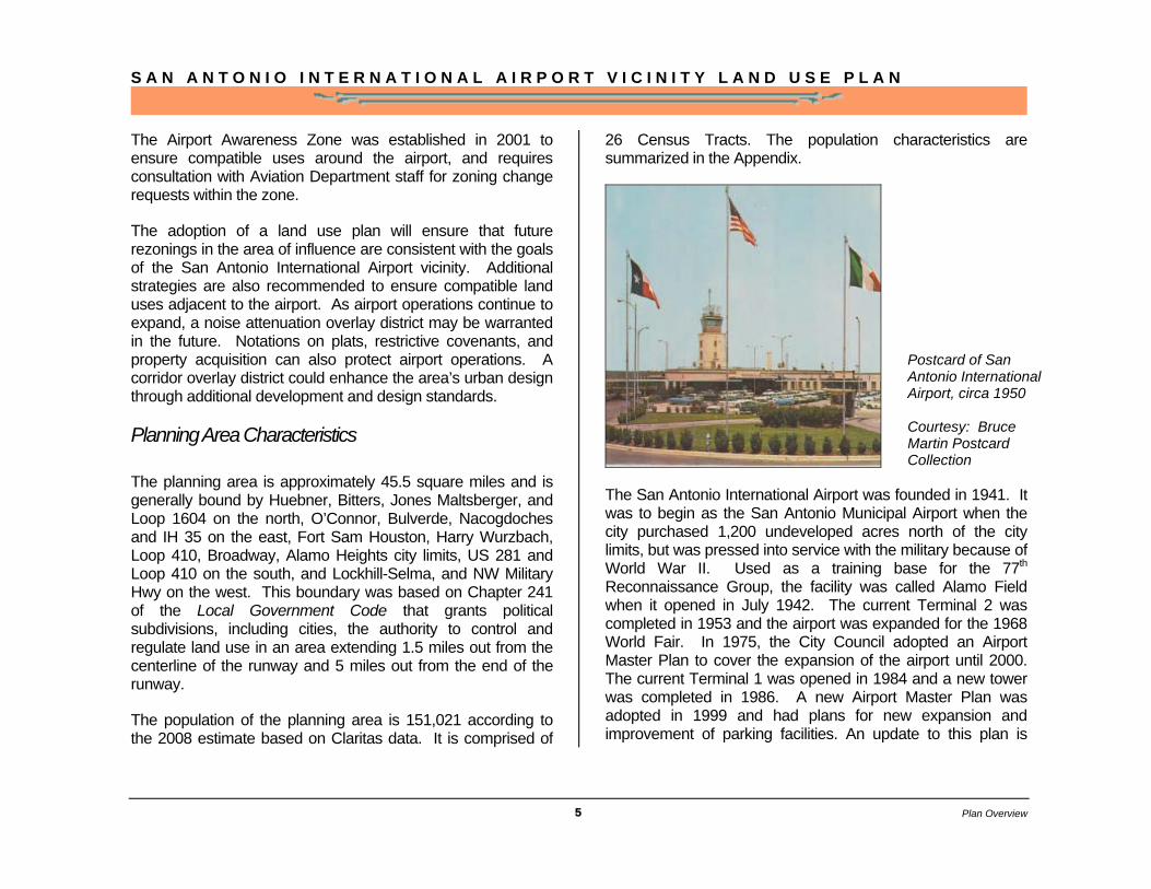
The San Antonio International Airport was founded in 1941. It was to begin as the San Antonio Municipal Airport when the city purchased 1,200 undeveloped acres north of the city limits, but was pressed into service with the military because of World War II. Used as a training base for the 77th Reconnaissance Group, the facility was called Alamo Field when it opened in July 1942. The current Terminal 2 was completed in 1953 and the airport was expanded for the 1968 World Fair. In 1975, the City Council adopted an Airport Master Plan to cover the expansion of the airport until 2000. The current Terminal 1 was opened in 1984 and a new tower was completed in 1986. A new Airport Master Plan was adopted in 1999 and had plans for new expansion and improvement of parking facilities. An update to this plan is
Postcard of San Antonio International Airport, circa 1950 Courtesy: Bruce Martin Postcard Collection
Plan Overview

S A N A N T O N I O I N T E R N A T I O N A L A I R P O R T V I C I N I T Y L A N D U S E P L A N
6
currently in the works. A recent major expansion program began in 2006 that included plans for two new terminals, adding a parking garage, and road system improvements. New cargo facilities, and Loop 410 and US Highway 281 interconnector have been completed. The San Antonio International Airport currently covers 2,600 acres and has three (3) active runways.
The San Antonio International Airport is vital to the economy of the city and the region. It supports new economic growth for travel and trade through passenger and cargo connections to international markets.
Planning Process, Effect of Land Use
Planning & Implementation
The planning process entailed public meetings, stakeholder meetings, a technical review committee, and interdepartmental review. Public input meetings were held on February 18, 2004, and February 19, 2004. Additional stakeholder meetings were held on February 29, 2004 and March 25, 2004. The purpose of these initial meetings was to review data and address potential land use controls and strategies around the airport. Area neighborhoods were notified of the meetings and a public meeting announcement was printed twice in the San Antonio-Express News Metro Section. Three community open house meetings were held on January 28, February 1 and 3, 2010 to allow final public comments on the plan.
The plan is presented to Planning Commission for recommendation and City Council for adoption as a component of the City’s Master Plan. The San Antonio International Airport Vicinity Land Use Plan is consistent with the 1997 San Antonio Master Plan Policies and the 1994 San Antonio Airport Master Plan Update. Additionally, it is consistent with the three neighborhood/community plans that border the planning area: North Central Neighborhoods Community Plan (2002), Northeast Inner Loop Neighborhood Plan Update (2008), and the Camelot I Neighborhood Plan Update (2004). Since all of these existing plans have their Future Land Use Plans, they were excluded from the original plan area which is described by the Texas Airport Compatibility Guidelines (see page 24).
Terminal Expansion Program
Planning Process
S A N A N T O N I O I N T E R N A T I O N A L A I R P O R T V I C I N I T Y L A N D U S E P L A N
7
City officials, departments, boards and commissions use the approved plan as a guide for decision-making regarding land use management and development in the vicinity of San Antonio International Airport. The City of San Antonio with area stakeholders will work to accomplish the goals and objectives through the major action steps identified in the plan. Implementation may occur through neighborhood initiatives, capital projects, future bonds, state and federal funds, leveraged public/private funding, adoption of new zoning ordinances, and other city-sponsored programs. No financial commitment is made at the time of plan adoption.
The Federal Aviation Administration (FAA) is responsible for the administration of aircraft safety, navigable airspace, flight operations and noise control. For example the FAA administers operations related to issues in the air and on the ground including take off, flight patterns, air traffic corridors, traffic volumes, altitudes and flight schedules. It is also concerned with safety in the air and on the ground including runways, taxiways, air navigations facilities, airport design, and runway protection areas. Finally the FAA addresses the abatement of aircraft noise and emissions in air during take offs, landings, and on the ground by restricting aircraft size, types, and design.
While Federal and State agencies create guidelines, it is the local government that is charged with implementation and enforcement of the land use plan. The FAA does support the local government’s efforts through grants. As a recipient of an FAA airport development grant, a local government is required to assure appropriate actions have been made to restrict use of land adjacent to or near the airport and to protect any future Federal investment to meet air travel needs of citizens and businesses. Continuation of FAA funding is contingent on
adoption of a compatible land use plan. The FAA also makes grants from noise set-aside Airport Improvement Program funds to states and local governments for compatible land use plan coordination and implementation.
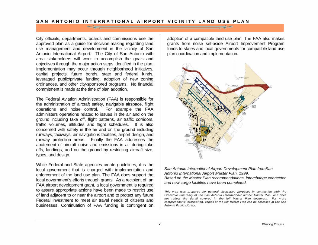
San Antonio International Airport Development Plan fromSan Antonio International Airport Master Plan, 1999. Based on the Master Plan recommendations, interchange connector and new cargo facilities have been completed. This map was prepared for general illustrative purposes in connection with the Executive Summary of the San Antonio International Airport Master Plan, and does not reflect the detail covered in the full Master Plan document. For more comprehensive information, copies of the full Master Plan can be accessed at the San Antonio Public Library.
Planning Process

S A N A N T O N I O I N T E R N A T I O N A L A I R P O R T V I C I N I T Y L A N D U S E P L A N
8
Plan Summary
The Plan Summary provides a quick reference guide to the goals of the San Antonio International Airport Vicinity Land Use Plan. The Plan contains three main chapters: 1) Land Use, 2) Compatibility and Redevelopment, and 3) Implementation.
L A N D U S E
Goal I: Protect the quality of life of residents including health, safety and welfare
Goal II: Encourage economic growth that enhances airport operations and development
C O M P A T I B I L I T Y A N D R E D E V E L O P M E N T
Goal III: Encourage a unique experience for airport patrons by creating gateways and enhancing the airport vicinity’s image through urban design
Goal IV: Develop a comprehensive set of development applications and incentives to implement the land use plan and continue noise attenuation efforts
I M P L E M E N T A T I O N
Goal V: Implement land use strategies in a coordinated, phased process
Plan Summary
S A N A N T O N I O I N T E R N A T I O N A L A I R P O R T V I C I N I T Y L A N D U S E P L A N
9
Current Land Use
Analysis/Current Land Use
The development of the planning area occurred primarily between 1951 and 1990. Loop 410, constructed in 1963-1964, greatly influenced the direction of growth in San Antonio. The areas immediately north and south of Loop 410 were annexed between 1951 and 1960. The areas which eventually became the neighborhoods of Harmony Hills, Countryside, Churchill Bluffs,
Devonshire Place and Northeast Park north of Loop 410, and North Alamo Heights, East Terrell Hills and Wilshire Park south of Loop 410. The balance of the area north of
Bitters, Starcrest and Wurzbach Parkway was annexed between 1960 and 1990.
The planning area is characteristic of America’s first- and second-tier suburban neighborhoods. The vast majority of these neighborhoods is fully built out, and has housing stock that is at least 30 years old and beginning to age. These areas generally enjoy higher rates of homeownership and educational attainment levels. They also are experiencing an increase in the older
population, a decrease in household size, and the diversification of ethnicity. A listing of these neighborhoods by planning area district is provided in the Appendix.
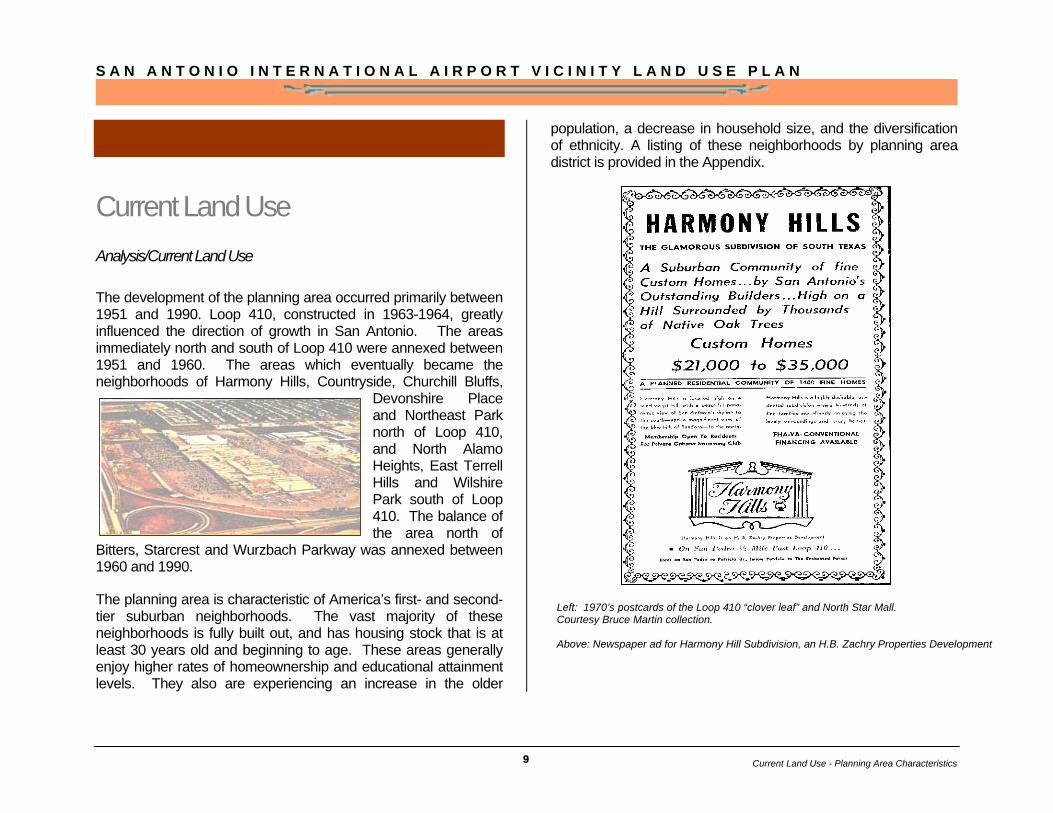
Left: 1970’s postcards of the Loop 410 “clover leaf” and North Star Mall. Courtesy Bruce Martin collection. Above: Newspaper ad for Harmony Hill Subdivision, an H.B. Zachry Properties Development
Current Land Use - Planning Area Characteristics
S A N A N T O N I O I N T E R N A T I O N A L A I R P O R T V I C I N I T Y L A N D U S E P L A N
10
The airport area is the third largest employment center in San Antonio, behind downtown and the Medical Center. Most retail, office and service uses are concentrated along Loop 410. In close proximity to the airport are airfront uses that improve the experience of airport patrons and enhance the efficiency and accessibility of the airport. This generally includes, but is not limited to rental car facilities, hotel establishments, shopping centers, restaurants, and travel agencies.
Other aviation uses found near the airport area are specific industrial, commercial, office and warehouse functions such as ground support equipment and repair and aircraft parts and supply. Business parks, strategically located near the airport, support office uses through flex space and warehousing.
As markets change and anchors relocate to newer sectors of San Antonio to follow new residential developments, some commercial strips in these maturing suburban neighborhoods are experiencing decline. Older commercial corridors such as Austin Highway, Perrin Beitel, Walzem and West have strong redevelopment potential and could benefit from commercial
retrofit and mixed use developments. Vacant “big boxes” or declining shopping centers could be converted into mixed use centers using infill development strategies.
Future stations for commuter rail, light rail, and bus rapid transit could provide unique transit oriented development opportunities in key locations along major corridors. Using transit oriented development, mixed residential and commercial use would be appropriate at major transit nodes outside of the noise exposure contours.
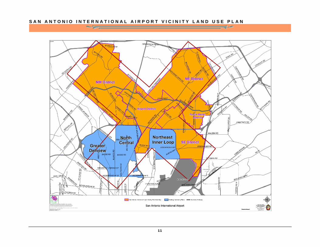
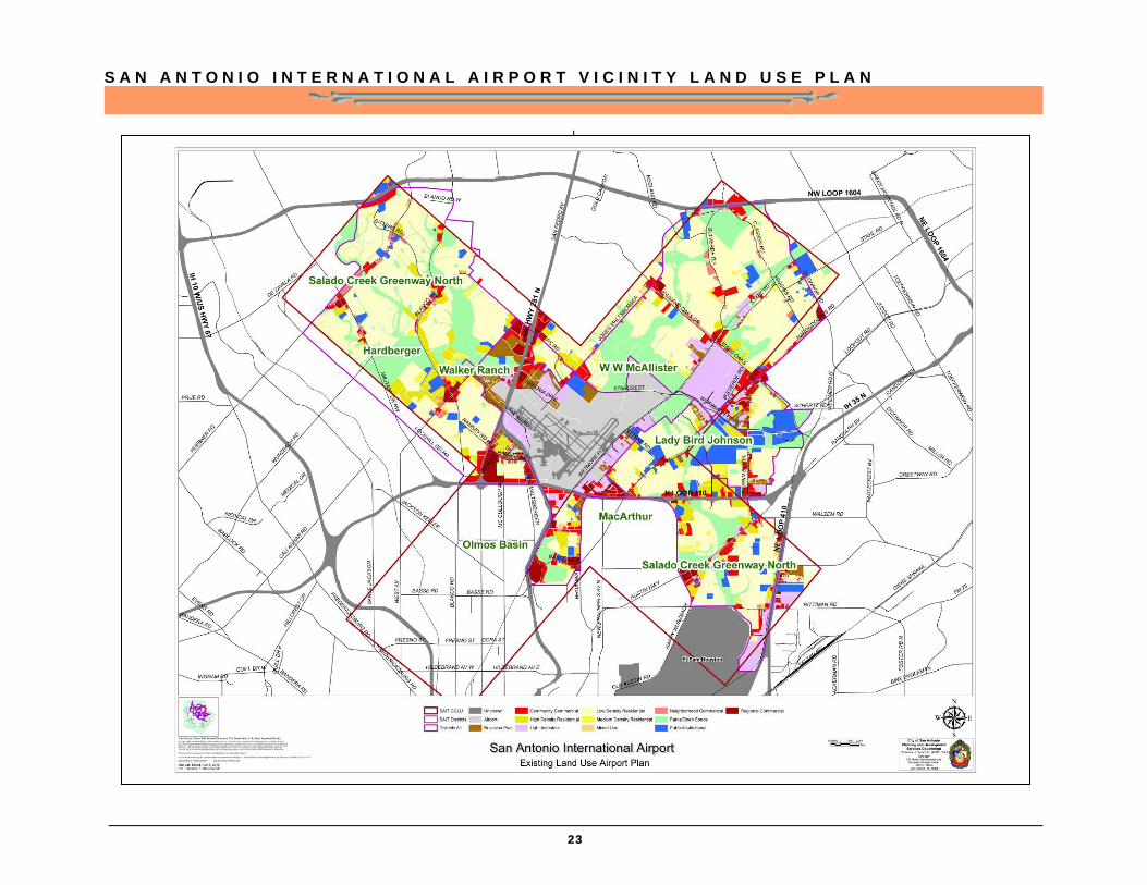
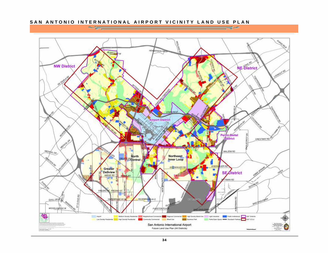
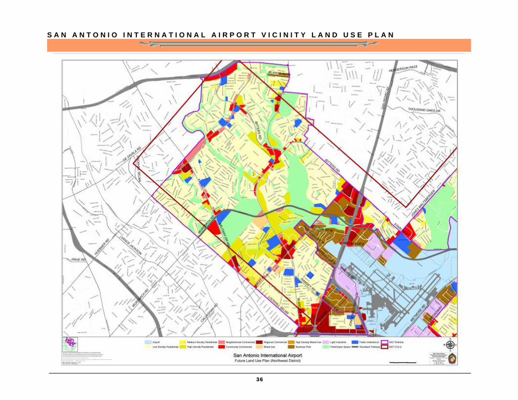
For the purpose of this analysis, the planning area was divided into five districts: the Airport, Northwest, Northeast, Perrin-Beitel, and Southeast districts. The map on page 11 shows the district boundaries. Each district is described and redevelopment potential is assessed.
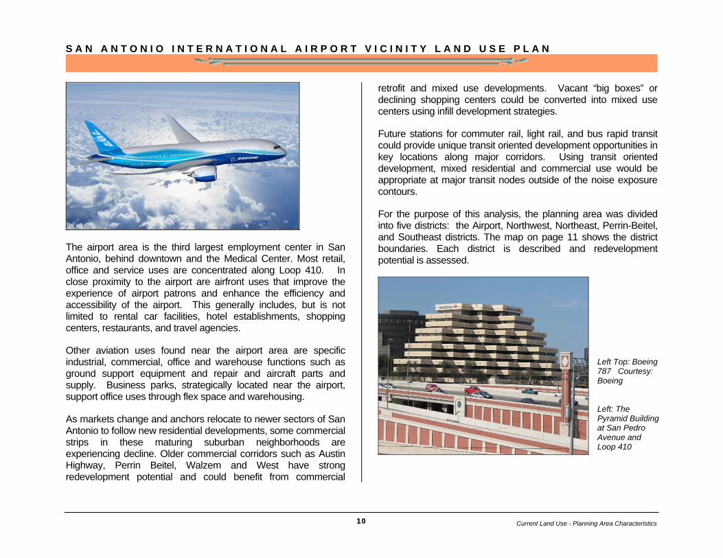
Left Top: Boeing 787 Courtesy: Boeing Left: The Pyramid Building at San Pedro Avenue and Loop 410
Current Land Use - Planning Area Characteristics
S A N A N T O N I O I N T E R N A T I O N A L A I R P O R T V I C I N I T Y L A N D U S E P L A N
11
S A N A N T O N I O I N T E R N A T I O N A L A I R P O R T V I C I N I T Y L A N D U S E P L A N
12
The exhibit above (previous page) shows where existing land use plans, Greater Dellview Community Plan, North Central Community Plan and Northeast Inner Loop Community Plan, are located in the area and how they define the plan area shape. Since these existing plans have already land use component within them, they were not included into Airport Vicinity Land Use Plan.
Plan Area Districts
Airport District – This district capitalizes on and serves the airport industry through airfront related businesses that support and enhance the experience of airport patrons. This includes car rental facilities, parking operations, business and office parks, banks, hotels, shopping and other associated retail and service.
In 2008, TxDOT completed the construction of the Loop 410 and US 281 interchange. This has immensely improved traffic circulation to and around the airport and accessibility to airfront uses.
A major regional commercial node is located at Bitters and US 281. The Embassy Oaks is an amusement and retail center consisting of a skate center, restaurants, night clubs and Santikos theaters. San Pedro Square south of Embassy Oaks, features large scale retail stores.
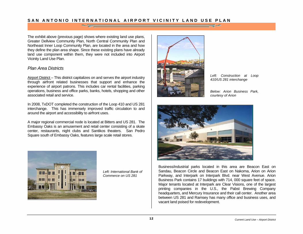
Business/industrial parks located in this area are Beacon East on Sandau, Beacon Circle and Beacon East on Nakoma, Arion on Arion Parkway, and Interpark on Interpark Blvd. near West Avenue. Arion Business Park contains 17 buildings with 714, 000 square feet of space. Major tenants located at Interpark are Clear Visions, one of the largest printing companies in the U.S., the Pabst Brewing Company headquarters, and Mercury Insurance and their call center. Another area between US 281 and Ramsey has many office and business uses, and vacant land poised for redevelopment.
Left: Construction at Loop 410/US 281 interchange Below: Arion Business Park, courtesy of Arion
Left: International Bank of Commerce on US 281
Current Land Use – Airport District
S A N A N T O N I O I N T E R N A T I O N A L A I R P O R T V I C I N I T Y L A N D U S E P L A N
13
East of the airport between Wetmore and Broadway are numerous business park/industrial uses, many situated adjacent to the Union Pacific Railroad tracks. This eastern section of this district along Tesoro Drive is also home to Northeast Independent School District’s administrative offices.
Many of these business parks have unoccupied spaces and some are beginning to decline in appearance. Airfront uses in these parks could be cultivated through the promotion of existing economic development programs and new economic incentives.
A preliminary location for the proposed Austin-San Antonio commuter rail station to serve San Antonio International Airport may be around the intersection of Loop 410 and Wetmore Road, but sensitive to airport operations.
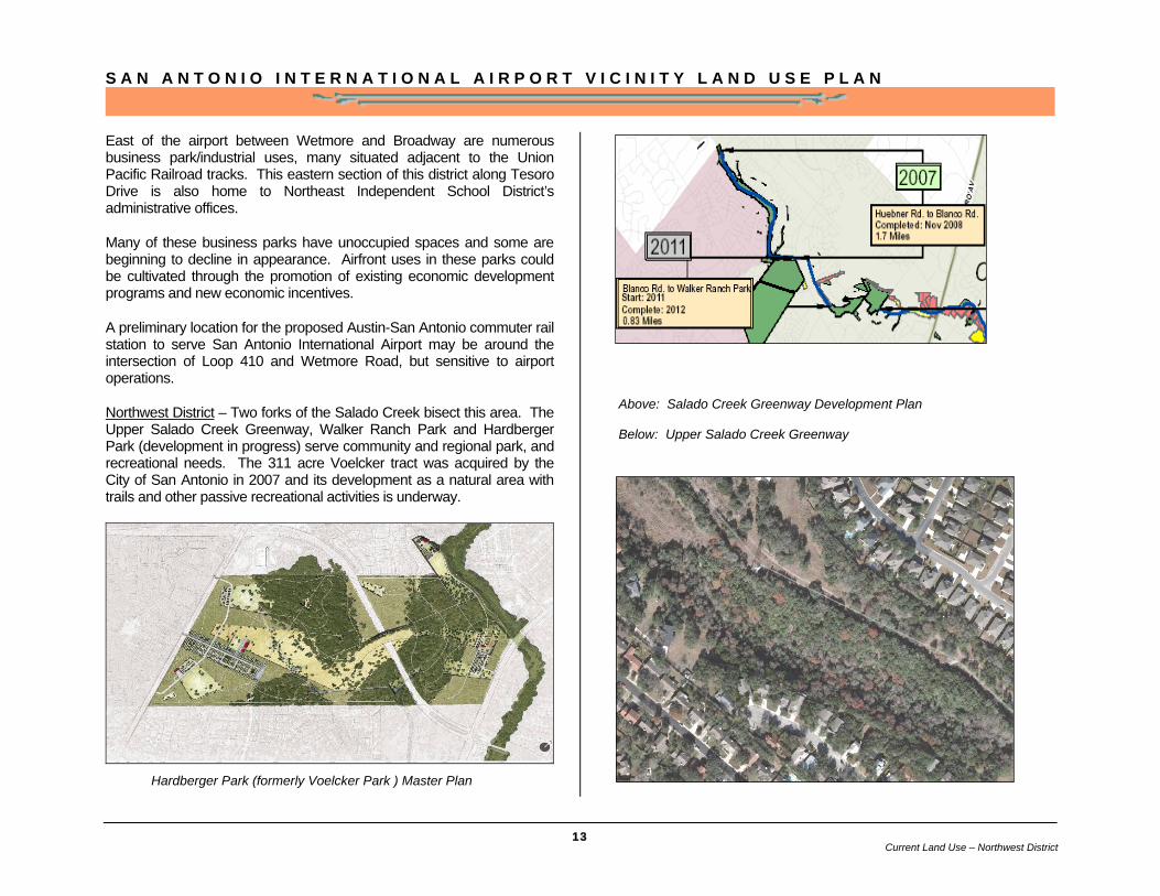
Northwest District – Two forks of the Salado Creek bisect this area. The Upper Salado Creek Greenway, Walker Ranch Park and Hardberger Park (development in progress) serve community and regional park, and recreational needs. The 311 acre Voelcker tract was acquired by the City of San Antonio in 2007 and its development as a natural area with trails and other passive recreational activities is underway.
Above: Salado Creek Greenway Development Plan Below: Upper Salado Creek Greenway
Hardberger Park (formerly Voelcker Park ) Master Plan
Current Land Use – Northwest District
S A N A N T O N I O I N T E R N A T I O N A L A I R P O R T V I C I N I T Y L A N D U S E P L A N
14
Existence of these parks in the plan area, especially Salado Creek’s location which is immediately north of the airport, is vital in terms of maintaining the open space character of this area and preventing any encroachment of incompatible uses around the airport.
Residential uses are primarily single family with large multifamily developments primarily north of West Avenue and along Blanco Road. Most of the single family residential subdivisions feature mature tree canopies and tree lined streets.
A prominent amenity in the Camino Real neighborhoods is the Silverhorn Golf Club which opened in 1997, and includes a par 72 golf course and special events conference center.
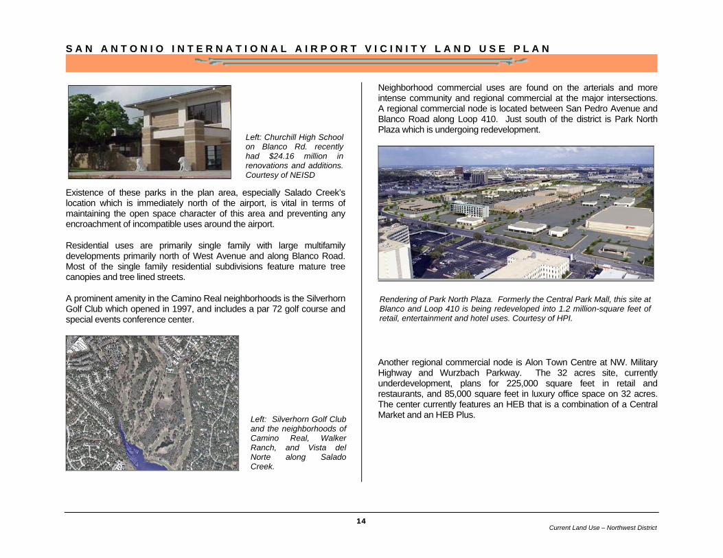
Neighborhood commercial uses are found on the arterials and more intense community and regional commercial at the major intersections. A regional commercial node is located between San Pedro Avenue and Blanco Road along Loop 410. Just south of the district is Park North Plaza which is undergoing redevelopment.
Another regional commercial node is Alon Town Centre at NW. Military Highway and Wurzbach Parkway. The 32 acres site, currently underdevelopment, plans for 225,000 square feet in retail and restaurants, and 85,000 square feet in luxury office space on 32 acres. The center currently features an HEB that is a combination of a Central Market and an HEB Plus.
Rendering of Park North Plaza. Formerly the Central Park Mall, this site at Blanco and Loop 410 is being redeveloped into 1.2 million-square feet of retail, entertainment and hotel uses. Courtesy of HPI.
Left: Silverhorn Golf Club and the neighborhoods of Camino Real, Walker Ranch, and Vista del Norte along Salado Creek.
Left: Churchill High School on Blanco Rd. recently had $24.16 million in renovations and additions. Courtesy of NEISD
Current Land Use – Northwest District
S A N A N T O N I O I N T E R N A T I O N A L A I R P O R T V I C I N I T Y L A N D U S E P L A N
15
Northeast – This area is predominantly single family residential, with some multifamily residential uses located on corridors. Conventional subdivisions are the dominant residential development pattern; however, some large lot residential estates were built northeast of the airport near Classen and Stahl Roads.
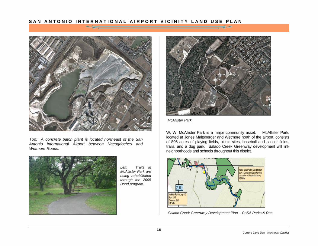
Neighborhood commercial uses are found on the arterials and more intense community and regional commercial at the major intersections. Located on Wetmore Road near Wurzbach Parkway, a concrete batch plant could potentially be redeveloped as a regional commercial center when its productivity becomes exhausted. Corridors just to the east that are ripe for commercial redevelopment are Naco Perrin and Perrin Beitel.
.
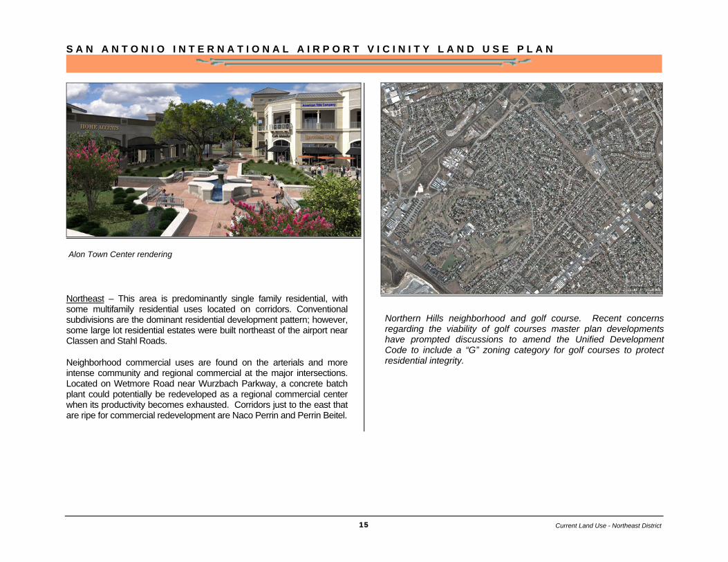
Northern Hills neighborhood and golf course. Recent concerns regarding the viability of golf courses master plan developments have prompted discussions to amend the Unified Development Code to include a “G” zoning category for golf courses to protect residential integrity.
Alon Town Center rendering
Current Land Use - Northeast District
S A N A N T O N I O I N T E R N A T I O N A L A I R P O R T V I C I N I T Y L A N D U S E P L A N
16
W. W. McAllister Park is a major community asset. McAllister Park, located at Jones Maltsberger and Wetmore north of the airport, consists of 896 acres of playing fields, picnic sites, baseball and soccer fields, trails, and a dog park. Salado Creek Greenway development will link neighborhoods and schools throughout this district.
Salado Creek Greenway Development Plan – CoSA Parks & Rec
Top: A concrete batch plant is located northeast of the San Antonio International Airport between Nacogdoches and Wetmore Roads.
Left: Trails in McAllister Park are being rehabilitated through the 2005 Bond program.
McAllister Park
Current Land Use - Northeast District
S A N A N T O N I O I N T E R N A T I O N A L A I R P O R T V I C I N I T Y L A N D U S E P L A N
17
Perrin-Beitel – The Perrin Beitel district is centered on the intersection of Wurzbach Parkway and Perrin Beitel road. Institutional, residential, and open space uses are the most prevalent in the area. The U.S. Post Office Main Station is on Perrin Beitel Rd. and is a major activity hub. Some industrial and business park uses are located on Nacogdoches Rd. Perrin Beitel, the major commercial spine, is struggling to sustain commercial uses, but is suffering some decline. This corridor presents opportunities for redevelopment, especially the area near the intersection with Loop 410 that could be transformed into a mixed use town center.
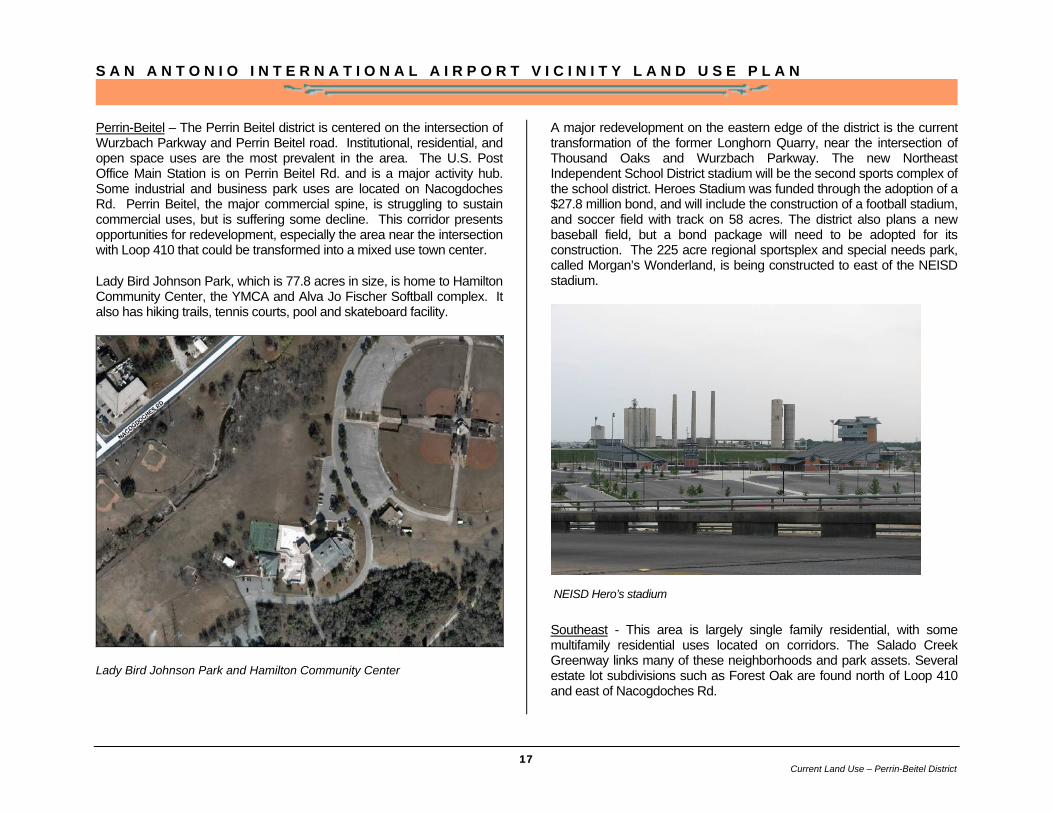
Lady Bird Johnson Park, which is 77.8 acres in size, is home to Hamilton Community Center, the YMCA and Alva Jo Fischer Softball complex. It also has hiking trails, tennis courts, pool and skateboard facility.
Lady Bird Johnson Park and Hamilton Community Center
A major redevelopment on the eastern edge of the district is the current transformation of the former Longhorn Quarry, near the intersection of Thousand Oaks and Wurzbach Parkway. The new Northeast Independent School District stadium will be the second sports complex of the school district. Heroes Stadium was funded through the adoption of a $27.8 million bond, and will include the construction of a football stadium, and soccer field with track on 58 acres. The district also plans a new baseball field, but a bond package will need to be adopted for its construction. The 225 acre regional sportsplex and special needs park, called Morgan’s Wonderland, is being constructed to east of the NEISD stadium.
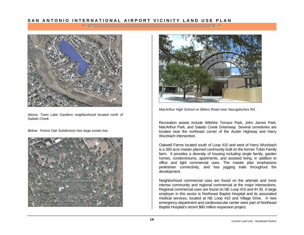
Southeast - This area is largely single family residential, with some multifamily residential uses located on corridors. The Salado Creek Greenway links many of these neighborhoods and park assets. Several estate lot subdivisions such as Forest Oak are found north of Loop 410 and east of Nacogdoches Rd.
NEISD Hero’s stadium
Current Land Use – Perrin-Beitel District
S A N A N T O N I O I N T E R N A T I O N A L A I R P O R T V I C I N I T Y L A N D U S E P L A N
18
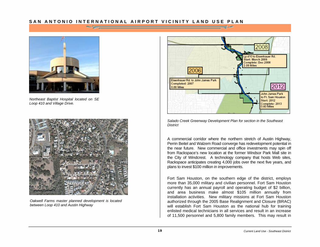
MacArthur High School on Bitters Road near Nacogdoches Rd..
Recreation assets include Wilshire Terrace Park, John James Park, MacArthur Park, and Salado Creek Greenway. Several cemeteries are located near the northeast corner of the Austin Highway and Harry Wurzbach intersection.
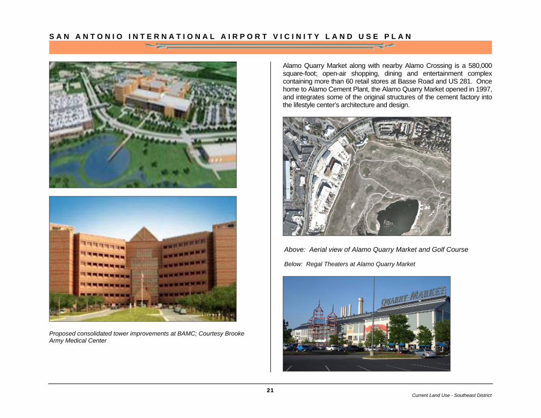
Oakwell Farms located south of Loop 410 and west of Harry Wurzbach is a 350 acre master planned community built on the former Tobin Family farm. It provides a diversity of housing including single family, garden homes, condominiums, apartments, and assisted living, in addition to office and light commercial uses. The master plan emphasizes pedestrian connectivity, and has jogging trails throughout the development.
Neighborhood commercial uses are found on the arterials and more intense community and regional commercial at the major intersections. Regional commercial uses are found on NE Loop 410 and IH 35. A large employer in this sector is Northeast Baptist Hospital and its associated medical services, located at NE Loop 410 and Village Drive. A new emergency department and cardiovascular center were part of Northeast Baptist Hospital’s recent $80 million expansion project.
Above: Town Lake Gardens neighborhood located north of Salado Creek. Below: Forest Oak Subdivision has large estate lots.
Current Land Use - Perrin-Beitel District Current Land Use - Southeast District
S A N A N T O N I O I N T E R N A T I O N A L A I R P O R T V I C I N I T Y L A N D U S E P L A N
19
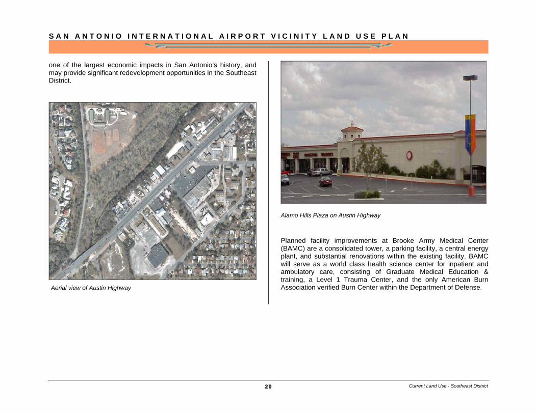
Salado Creek Greenway Development Plan for section in the Southeast District
A commercial corridor where the northern stretch of Austin Highway, Perrin Beitel and Walzem Road converge has redevelopment potential in the near future. New commercial and office investments may spin off from Rackspace’s new location at the former Windsor Park Mall site in the City of Windcrest. A technology company that hosts Web sites, Rackspace anticipates creating 4,000 jobs over the next five years, and plans to invest $100 million in improvements.
Fort Sam Houston, on the southern edge of the district, employs more than 35,000 military and civilian personnel. Fort Sam Houston currently has an annual payroll and operating budget of $2 billion, and area business make almost $105 million annually from installation activities. New military missions at Fort Sam Houston authorized through the 2005 Base Realignment and Closure (BRAC) will establish Fort Sam Houston as the national hub for training enlisted medical technicians in all services and result in an increase of 11,500 personnel and 5,800 family members. This may result in
Northeast Baptist Hospital located on SE Loop 410 and Village Drive.
Current Land Use - Southeast District
Oakwell Farms master planned development is located between Loop 410 and Austin Highway
S A N A N T O N I O I N T E R N A T I O N A L A I R P O R T V I C I N I T Y L A N D U S E P L A N
20
one of the largest economic impacts in San Antonio’s history, and may provide significant redevelopment opportunities in the Southeast District.
Alamo Hills Plaza on Austin Highway
Planned facility improvements at Brooke Army Medical Center (BAMC) are a consolidated tower, a parking facility, a central energy plant, and substantial renovations within the existing facility. BAMC will serve as a world class health science center for inpatient and ambulatory care, consisting of Graduate Medical Education & training, a Level 1 Trauma Center, and the only American Burn Association verified Burn Center within the Department of Defense. Aerial view of Austin Highway
Current Land Use - Southeast District
S A N A N T O N I O I N T E R N A T I O N A L A I R P O R T V I C I N I T Y L A N D U S E P L A N
21
Proposed consolidated tower improvements at BAMC; Courtesy Brooke Army Medical Center
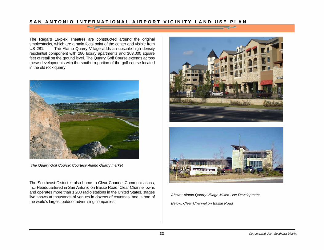
Alamo Quarry Market along with nearby Alamo Crossing is a 580,000 square-foot; open-air shopping, dining and entertainment complex containing more than 60 retail stores at Basse Road and US 281. Once home to Alamo Cement Plant, the Alamo Quarry Market opened in 1997, and integrates some of the original structures of the cement factory into the lifestyle center’s architecture and design.
Above: Aerial view of Alamo Quarry Market and Golf Course Below: Regal Theaters at Alamo Quarry Market
Current Land Use - Southeast District
S A N A N T O N I O I N T E R N A T I O N A L A I R P O R T V I C I N I T Y L A N D U S E P L A N
22
The Regal’s 16-plex Theatres are constructed around the original smokestacks, which are a main focal point of the center and visible from US 281. The Alamo Quarry Village adds an upscale high density residential component with 280 luxury apartments and 103,000 square feet of retail on the ground level. The Quarry Golf Course extends across these developments with the southern portion of the golf course located in the old rock quarry.
The Southeast District is also home to Clear Channel Communications, Inc. Headquartered in San Antonio on Basse Road, Clear Channel owns and operates more than 1,200 radio stations in the United States, stages live shows at thousands of venues in dozens of countries, and is one of the world’s largest outdoor advertising companies.
The Quarry Golf Course; Courtesy Alamo Quarry market
Current Land Use - Southeast District
Above: Alamo Quarry Village Mixed-Use Development Below: Clear Channel on Basse Road
S A N A N T O N I O I N T E R N A T I O N A L A I R P O R T V I C I N I T Y L A N D U S E P L A N
23
S A N A N T O N I O I N T E R N A T I O N A L A I R P O R T V I C I N I T Y L A N D U S E P L A N
24
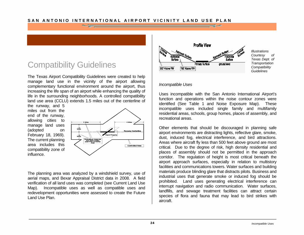
Compatibility Guidelines The Texas Airport Compatibility Guidelines were created to help manage land use in the vicinity of the airport allowing complementary functional environment around the airport, thus increasing the life span of an airport while enhancing the quality of life in the surrounding neighborhoods. A controlled compatibility land use area (CCLU) extends 1.5 miles out of the centerline of the runway, and 5 miles out from the end of the runway, allowing cities to manage land uses (adopted on February 18, 1969). The current planning area includes this compatibility zone of influence.
The planning area was analyzed by a windshield survey, use of aerial maps, and Bexar Appraisal District data in 2008. A field verification of all land uses was completed (see Current Land Use Map). Incompatible uses as well as compatible uses and redevelopment opportunities were assessed to create the Future Land Use Plan.
Incompatible Uses
Uses incompatible with the San Antonio International Airport’s function and operations within the noise contour zones were identified (See Table 1 and Noise Exposure Map). These incompatible uses included single family and multifamily residential areas, schools, group homes, places of assembly, and recreational areas.
Other elements that should be discouraged in planning safe airport environments are distracting lights, reflective glare, smoke, dust, induced fog, electrical interference, and bird attractions. Areas where aircraft fly less than 500 feet above ground are most critical. Due to the degree of risk, high density residential and places of assembly should not be permitted in the approach corridor. The regulation of height is most critical beneath the airport approach surfaces, especially in relation to multistory facilities and communications towers. Water surfaces and building materials produce blinding glare that distracts pilots. Business and industrial uses that generate smoke or induced fog should be prohibited. Land uses generating electrical interference can interrupt navigation and radio communication. Water surfaces, landfills, and sewage treatment facilities can attract certain species of flora and fauna that may lead to bird strikes with aircraft.
Illustrations Courtesy of Texas Dept. of Transportation Compatibility Guidelines
Incompatible Uses

S A N A N T O N I O I N T E R N A T I O N A L A I R P O R T V I C I N I T Y L A N D U S E P L A N
25
One of the greatest concerns is the encroachment of residential uses, both single-family and multi-family, and other noise sensitive uses in approach areas. Noise is the primary nuisance generated by airport operations and has an inordinate impact on development in the immediate vicinity of the airport.
The Federal Aviation Administration and the Texas Department of Transportation Aviation Division have issued guidelines that characterize land uses that are incompatible with certain noise levels. Generally all uses are permitted at a noise level of less than 65 decibels. Based on these guidelines the most sensitive areas under consideration are those that experience a noise level greater than 65 decibels. These uses are based on the Day-Night Average Sound Level (DNL) with is measured for a 24 hour period.
A noise compatibility program contains measures that an airport has taken or has proposed for reduction in incompatible noise and land uses. These methods range from operational and preventive measures to remediation. Operational measures include restrictions pertaining to aircraft design, types, and size, as well as flight patterns, schedules, and runway and taxiway design. Preventive measures entail the adoption of zoning overlay ordinances to prevent further encroachment of incompatible noise and uses. Remediation includes the treatment of residential properties exposed to significant noise, with more dense construction and additional insulation; or the installation of earthen berms or walls to mitigate engine run-up.
As time has passed technological improvements have been made to reduce the noise impact of aircraft and aviation operations. These measures have ranged from the addition of “hush kits” to jet engines, to the design and implementation of residential construction codes that require the inclusion of specific measures to reduce the level of noise perceived inside the residence. As
further improvements in technology are adopted by the aviation and development communities, the boundaries of these noise contours may shrink over time.
TABLE 1 Land Use Compatibility* With Yearly Day-Night Average Sound Levels
Yearly day-night average sound level (Ldn) in decibels
Land Use Below 65
65–70
70–75
75–80
80–85
Over 85
Residential Residential, other than mobile homes and transient lodgings Y N(1) N(1) N N N
Mobile home parks Y N N N N N Transient lodgings Y N(1) N(1) N(1) N N
Public Use Schools Y N(1) N(1) N N N Hospitals and nursing homes Y 25 30 N N N Churches, auditoriums, and concert halls Y 25 30 N N N
Governmental services Y Y 25 30 N N Transportation Y Y Y(2) Y(3) Y(4) Y(4) Parking Y Y Y(2) Y(3) Y(4) N
Commercial Use Offices, business and professional Y Y 25 30 N N Wholesale and retail—building materials, hardware and farm equipment Y Y Y(2) Y(3) Y(4) N
Retail trade—general Y Y 25 30 N N Utilities Y Y Y(2) Y(3) Y(4) N Communication Y Y 25 30 N N
Manufacturing and Production Manufacturing, general Y Y Y(2) Y(3) Y(4) N
Land Use Below 65
65–70
70–75
75–80
80–85
Over 85
Photographic and optical Y Y 25 30 N N
Incompatible Uses
S A N A N T O N I O I N T E R N A T I O N A L A I R P O R T V I C I N I T Y L A N D U S E P L A N
26
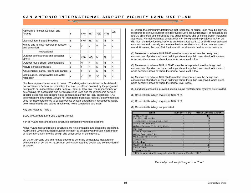
Agriculture (except livestock) and forestry
Y Y(6) Y(7) Y(8) Y(8) Y(8)
Livestock farming and breeding Y Y(6) Y(7) N N N Mining and fishing, resource production and extraction Y Y Y Y Y Y
Recreational Outdoor sports arenas and spectator sports Y Y(5) Y(5) N N N
Outdoor music shells, amphitheaters Y N N N N N Nature exhibits and zoos Y Y N N N N Amusements, parks, resorts and camps Y Y Y N N N Golf courses, riding stables and water recreation Y Y 25 30 N N
Numbers in parentheses refer to notes. *The designations contained in this table do not constitute a Federal determination that any use of land covered by the program is acceptable or unacceptable under Federal, State, or local law. The responsibility for determining the acceptable and permissible land uses and the relationship between specific properties and specific noise contours rests with the local authorities. FAA determinations under part 150 are not intended to substitute federally determined land uses for those determined to be appropriate by local authorities in response to locally determined needs and values in achieving noise compatible land uses.
Key and Notes to Table 1
SLUCM=Standard Land Use Coding Manual.
Y (Yes)=Land Use and related structures compatible without restrictions.
N (No)=Land Use and related structures are not compatible and should be prohibited. NLR=Noise Level Reduction (outdoor to indoor) to be achieved through incorporation of noise attenuation into the design and construction of the structure.
25, 30, or 35=Land use and related structures generally compatible; measures to achieve NLR of 25, 30, or 35 dB must be incorporated into design and construction of structure.
(1) Where the community determines that residential or school uses must be allowed, measures to achieve outdoor to indoor Noise Level Reduction (NLR) of at least 25 dB and 30 dB should be incorporated into building codes and be considered in individual approvals. Normal residential construction can be expected to provide a NLR of 20 dB, thus, the reduction requirements are often stated as 5, 10 or 15 dB over standard construction and normally assume mechanical ventilation and closed windows year round. However, the use of NLR criteria will not eliminate outdoor noise problems.
(2) Measures to achieve NLR 25 dB must be incorporated into the design and construction of portions of these buildings where the public is received, office areas, noise sensitive areas or where the normal noise level is low.
(3) Measures to achieve NLR of 30 dB must be incorporated into the design and construction of portions of these buildings where the public is received, office areas, noise sensitive areas or where the normal noise level is low.
(4) Measures to achieve NLR 35 dB must be incorporated into the design and construction of portions of these buildings where the public is received, office areas, noise sensitive areas or where the normal level is low.
(5) Land use compatible provided special sound reinforcement systems are installed.
(6) Residential buildings require an NLR of 25.
(7) Residential buildings require an NLR of 30.
(8) Residential buildings not permitted.
Incompatible Uses
Decibel (Loudness) Comparison Chart

S A N A N T O N I O I N T E R N A T I O N A L A I R P O R T V I C I N I T Y L A N D U S E P L A N
27
Noise Exposure Map
The Noise Exposure Map (NEM) was adopted by the City of San Antonio on April 19, 2009 and Federal Aviation Administration (FAA) on May 28, 2009. The most up-to-date Noise Exposure Map can be accessed via Aviation Department’s web site: http://www.sanantonio.gov/Aviation/Environmental.asp
S A N A N T O N I O I N T E R N A T I O N A L A I R P O R T V I C I N I T Y L A N D U S E P L A N
28
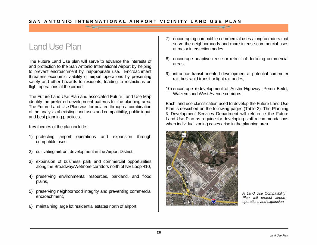
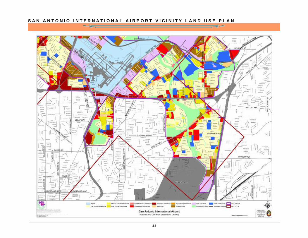
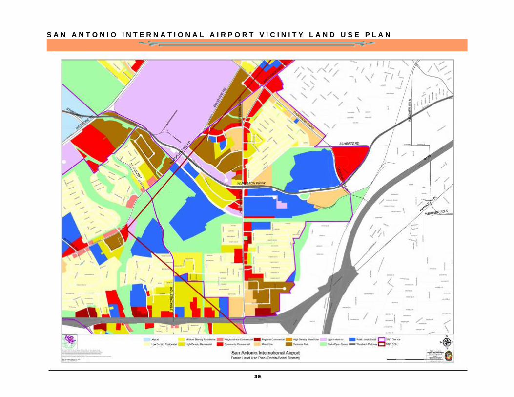
Land Use Plan The Future Land Use plan will serve to advance the interests of and protection to the San Antonio International Airport by helping to prevent encroachment by inappropriate use. Encroachment threatens economic viability of airport operations by presenting safety and other hazards to residents, leading to restrictions on flight operations at the airport.
The Future Land Use Plan and associated Future Land Use Map identify the preferred development patterns for the planning area. The Future Land Use Plan was formulated through a combination of the analysis of existing land uses and compatibility, public input, and best planning practices.
Key themes of the plan include:
1) protecting airport operations and expansion through compatible uses,
2) cultivating airfront development in the Airport District,
3) expansion of business park and commercial opportunities along the Broadway/Wetmore corridors north of NE Loop 410,
4) preserving environmental resources, parkland, and flood plains,
5) preserving neighborhood integrity and preventing commercial encroachment,
6) maintaining large lot residential estates north of airport,
7) encouraging compatible commercial uses along corridors that serve the neighborhoods and more intense commercial uses at major intersection nodes,
8) encourage adaptive reuse or retrofit of declining commercial areas,
9) introduce transit oriented development at potential commuter rail, bus rapid transit or light rail nodes,
10) encourage redevelopment of Austin Highway, Perrin Beitel, Walzem, and West Avenue corridors
Each land use classification used to develop the Future Land Use Plan is described on the following pages (Table 2). The Planning & Development Services Department will reference the Future Land Use Plan as a guide for developing staff recommendations when individual zoning cases arise in the planning area.
A Land Use Compatibility Plan will protect airport operations and expansion
Land Use Plan
S A N A N T O N I O I N T E R N A T I O N A L A I R P O R T V I C I N I T Y L A N D U S E P L A N
29
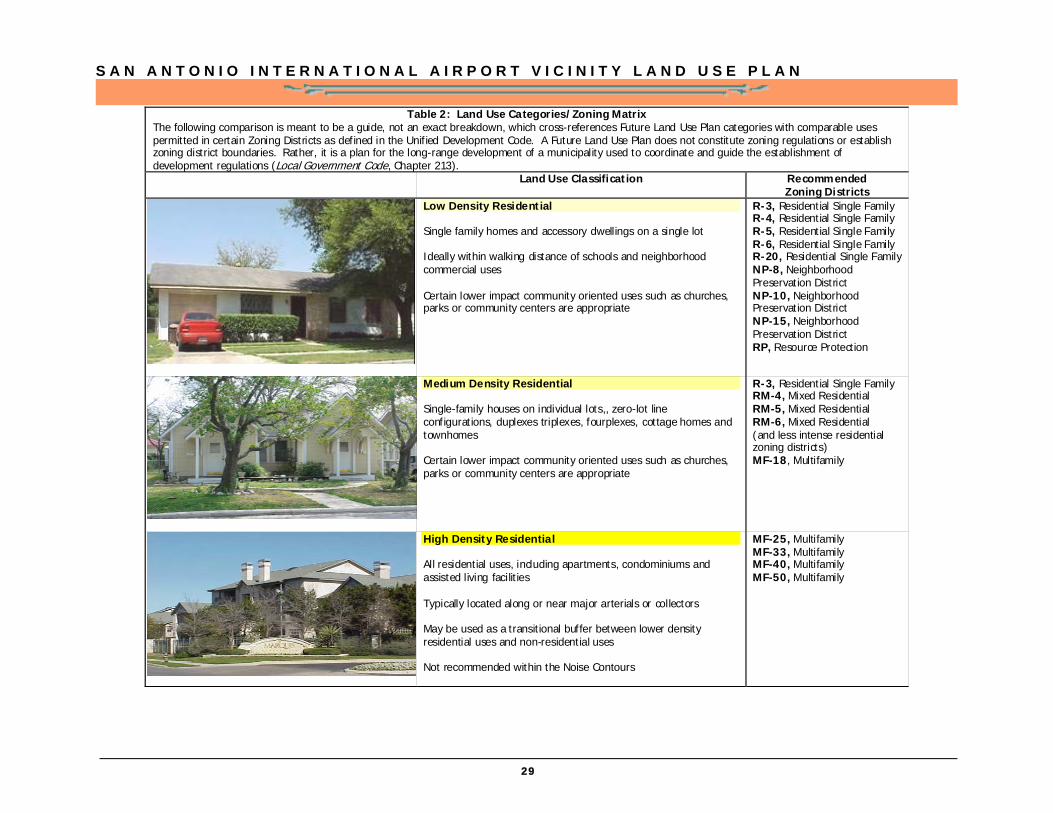
Table 2: Land Use Categories/Zoning Matrix The following comparison is meant to be a guide, not an exact breakdown, which cross-references Future Land Use Plan categories with comparable uses permitted in certain Zoning Districts as defined in the Unified Development Code. A Future Land Use Plan does not constitute zoning regulations or establish zoning district boundaries. Rather, it is a plan for the long-range development of a municipality used to coordinate and guide the establishment of development regulations (Local Government Code, Chapter 213).
Land Use Classification Recommended Zoning Districts
Low Density Residential Single family homes and accessory dwellings on a single lot Ideally within walking distance of schools and neighborhood commercial uses Certain lower impact community oriented uses such as churches, parks or community centers are appropriate
R-3, Residential Single Family R-4, Residential Single Family R-5, Residential Single Family R-6, Residential Single Family R-20, Residential Single Family NP-8, Neighborhood Preservation District NP-10, Neighborhood Preservation District NP-15, Neighborhood Preservation District RP, Resource Protection
Medium Density Residential Single-family houses on individual lots,, zero-lot line configurations, duplexes triplexes, fourplexes, cottage homes and townhomes Certain lower impact community oriented uses such as churches, parks or community centers are appropriate
R-3, Residential Single Family RM-4, Mixed Residential RM-5, Mixed Residential RM-6, Mixed Residential (and less intense residential zoning districts) MF-18, Multifamily
High Density Residential All residential uses, including apartments, condominiums and assisted living facilities Typically located along or near major arterials or collectors May be used as a transitional buffer between lower density residential uses and non-residential uses Not recommended within the Noise Contours
MF-25, Multifamily MF-33, Multifamily MF-40, Multifamily MF-50, Multifamily
S A N A N T O N I O I N T E R N A T I O N A L A I R P O R T V I C I N I T Y L A N D U S E P L A N
30
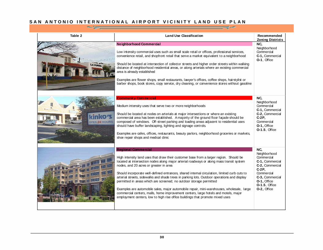
Table 2
Land Use Classification Recommended Zoning Districts
Neighborhood Commercial Low intensity commercial uses such as small scale retail or offices, professional services, convenience retail, and shopfront retail that serve a market equivalent to a neighborhood Should be located at intersection of collector streets and higher order streets within walking distance of neighborhood residential areas, or along arterials where an existing commercial area is already established Examples are flower shops, small restaurants, lawyer’s offices, coffee shops, hairstylist or barber shops, book stores, copy service, dry cleaning, or convenience stores without gasoline
NC, Neighborhood Commercial C-1, Commercial O-1, Office
Community Commercial Medium intensity uses that serve two or more neighborhoods Should be located at nodes on arterials at major intersections or where an existing commercial area has been established. A majority of the ground floor façade should be composed of windows. Off-street parking and loading areas adjacent to residential uses should have buffer landscaping, lighting and signage controls. Examples are cafes, offices, restaurants, beauty parlors, neighborhood groceries or markets, shoe repair shops and medical clinic
NC, Neighborhood Commercial C-1, Commercial C-2, Commercial C-2P, Commercial O-1, Office O-1.5, Office
Regional Commercial High intensity land uses that draw their customer base from a larger region. Should be located at intersection nodes along major arterial roadways or along mass transit system nodes, and 20 acres or greater in area Should incorporate well-defined entrances, shared internal circulation, limited curb cuts to arterial streets, sidewalks and shade trees in parking lots. Outdoor operations and display permitted in areas which are screened; no outdoor storage permitted Examples are automobile sales, major automobile repair, mini-warehouses, wholesale, large commercial centers, malls, home improvement centers, large hotels and motels, major employment centers, low to high rise office buildings that promote mixed uses
NC, Neighborhood Commercial C-1, Commercial C-2, Commercial C-2P, Commercial C-3, Commercial O-1, Office O-1.5, Office O-2, Office
S A N A N T O N I O I N T E R N A T I O N A L A I R P O R T V I C I N I T Y L A N D U S E P L A N
31
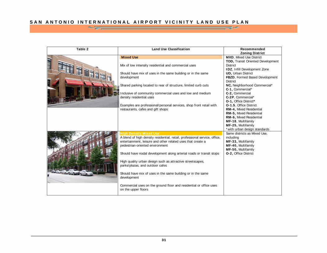
Table 2 Land Use Classification Recommended Zoning District
Mixed Use Mix of low intensity residential and commercial uses Should have mix of uses in the same building or in the same development Shared parking located to rear of structure, limited curb cuts Inclusive of community commercial uses and low and medium density residential uses Examples are professional/personal services, shop front retail with restaurants, cafes and gift shops
MXD, Mixed Use District TOD, Transit Oriented Development District IDZ, Infill Development Zone UD, Urban District FBZD, Formed Based Development District NC, Neighborhood Commercial* C-1, Commercial* C-2, Commercial C-2P, Commercial* O-1, Office District* O-1.5, Office District RM-4, Mixed Residential RM-5, Mixed Residential RM-6, Mixed Residential MF-18, Multifamily MF-25, Multifamily *with urban design standards
High Density Mixed Use A blend of high density residential, retail, professional service, office, entertainment, leisure and other related uses that create a pedestrian-oriented environment Should have nodal development along arterial roads or transit stops High quality urban design such as attractive streetscapes, parks/plazas, and outdoor cafes Should have mix of uses in the same building or in the same development Commercial uses on the ground floor and residential or office uses on the upper floors
Same districts as Mixed Use, including MF-33, Multifamily MF-40, Multifamily MF-50, Multifamily O-2, Office District
S A N A N T O N I O I N T E R N A T I O N A L A I R P O R T V I C I N I T Y L A N D U S E P L A N
32
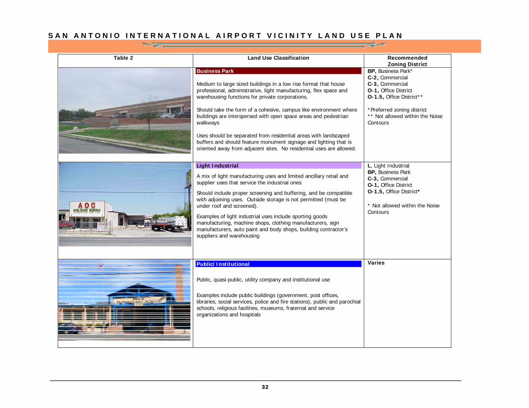
Table 2 Land Use Classification Recommended Zoning District
Business Park Medium to large sized buildings in a low rise format that house professional, administrative, light manufacturing, flex space and warehousing functions for private corporations. Should take the form of a cohesive, campus like environment where buildings are interspersed with open space areas and pedestrian walkways Uses should be separated from residential areas with landscaped buffers and should feature monument signage and lighting that is oriented away from adjacent sites. No residential uses are allowed.
BP, Business Park* C-2, Commercial C-3, Commercial O-1, Office District O-1.5, Office District** *Preferred zoning district ** Not allowed within the Noise Contours
Light Industrial
A mix of light manufacturing uses and limited ancillary retail and supplier uses that service the industrial ones
Should include proper screening and buffering, and be compatible with adjoining uses. Outside storage is not permitted (must be under roof and screened).
Examples of light industrial uses include sporting goods manufacturing, machine shops, clothing manufacturers, sign manufacturers, auto paint and body shops, building contractor’s suppliers and warehousing
L, Light Industrial BP, Business Park C-3, Commercial O-1, Office District O-1.5, Office District* * Not allowed within the Noise Contours
Public/Institutional Public, quasi-public, utility company and institutional use Examples include public buildings (government, post offices, libraries, social services, police and fire stations), public and parochial schools, religious facilities, museums, fraternal and service organizations and hospitals
Varies
S A N A N T O N I O I N T E R N A T I O N A L A I R P O R T V I C I N I T Y L A N D U S E P L A N
33
Table 2 Land Use Classification Recommended Zoning District
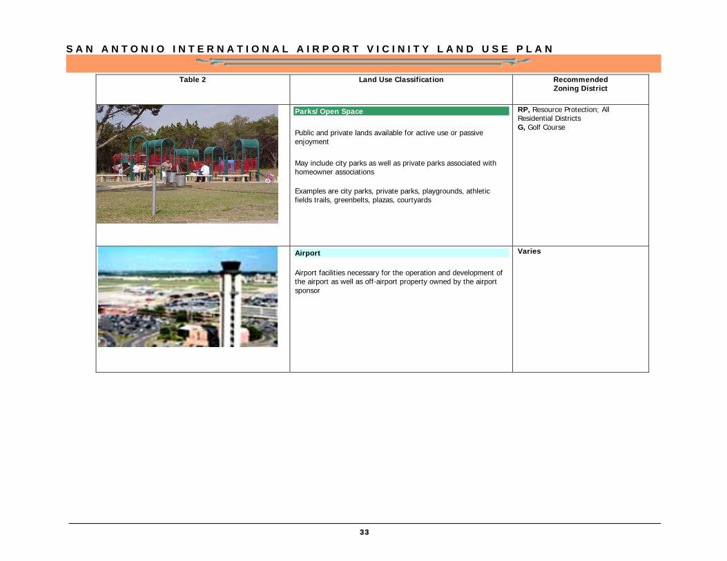
Parks/Open Space Public and private lands available for active use or passive enjoyment May include city parks as well as private parks associated with homeowner associations Examples are city parks, private parks, playgrounds, athletic fields trails, greenbelts, plazas, courtyards
RP, Resource Protection; All Residential Districts G, Golf Course
Airport Airport facilities necessary for the operation and development of the airport as well as off-airport property owned by the airport sponsor
Varies
S A N A N T O N I O I N T E R N A T I O N A L A I R P O R T V I C I N I T Y L A N D U S E P L A N
34

S A N A N T O N I O I N T E R N A T I O N A L A I R P O R T V I C I N I T Y L A N D U S E P L A N
35
S A N A N T O N I O I N T E R N A T I O N A L A I R P O R T V I C I N I T Y L A N D U S E P L A N
36

S A N A N T O N I O I N T E R N A T I O N A L A I R P O R T V I C I N I T Y L A N D U S E P L A N
37
S A N A N T O N I O I N T E R N A T I O N A L A I R P O R T V I C I N I T Y L A N D U S E P L A N
38
S A N A N T O N I O I N T E R N A T I O N A L A I R P O R T V I C I N I T Y L A N D U S E P L A N
39
S A N A N T O N I O I N T E R N A T I O N A L A I R P O R T V I C I N I T Y L A N D U S E P L A N
40
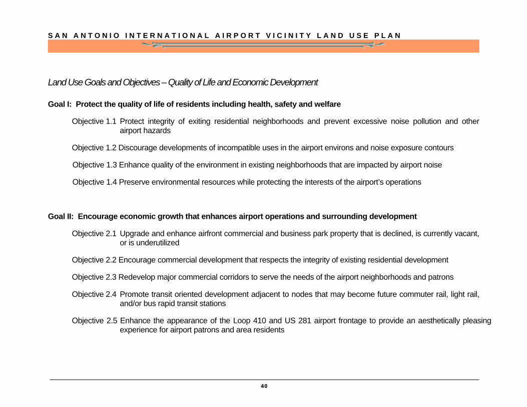
Land Use Goals and Objectives – Quality of Life and Economic Development
Goal I: Protect the quality of life of residents including health, safety and welfare
Objective 1.1 Protect integrity of exiting residential neighborhoods and prevent excessive noise pollution and other airport hazards
Objective 1.2 Discourage developments of incompatible uses in the airport environs and noise exposure contours
Objective 1.3 Enhance quality of the environment in existing neighborhoods that are impacted by airport noise
Objective 1.4 Preserve environmental resources while protecting the interests of the airport’s operations
Goal II: Encourage economic growth that enhances airport operations and surrounding development
Objective 2.1 Upgrade and enhance airfront commercial and business park property that is declined, is currently vacant, or is underutilized
Objective 2.2 Encourage commercial development that respects the integrity of existing residential development
Objective 2.3 Redevelop major commercial corridors to serve the needs of the airport neighborhoods and patrons
Objective 2.4 Promote transit oriented development adjacent to nodes that may become future commuter rail, light rail, and/or bus rapid transit stations
Objective 2.5 Enhance the appearance of the Loop 410 and US 281 airport frontage to provide an aesthetically pleasing experience for airport patrons and area residents

S A N A N T O N I O I N T E R N A T I O N A L A I R P O R T V I C I N I T Y L A N D U S E P L A N
41
Compatibility & Redevelopment
Along with this Future Land Use the City has several tools available for prevention or reduction of uses that conflict with runway flight paths or noise produced by the airport.
Current Strategies
Airport Hazard Overlay District
The Airport Hazard Overlay District (AHOD) is designed to prevent airport hazards that endanger the lives and property of the users of San Antonio International Airport and Stinson Municipal Airport, and the occupants of land in the vicinity of these facilities. Adopted in 1969, and amended in 1982, this district zones the area of influence and places restrictions on height as well as some uses. This is designed to prohibit uses that obstruct air space required for flight of aircraft, landing or take of; and electrical or visual interference that could affect flight control and operations. It also prohibits additional airports or flying fields and uses that may contribute to bird strikes or glare.
Airport Awareness Zone
The Airport Awareness Zone is a resolution between the Airports and the City of San Antonio Planning and Development Services Department requiring requests for building permits or zoning ordinance amendments within a designated boundary around the airports to result in airport notification. The boundaries of the Airport Awareness Zones encompass areas that may have a noise level of 65 DNL in order to synchronize and facilitate proposed development with potential aircraft noise.
Land Use Plan - Compatibility & Redevelopment
S A N A N T O N I O I N T E R N A T I O N A L A I R P O R T V I C I N I T Y L A N D U S E P L A N
42
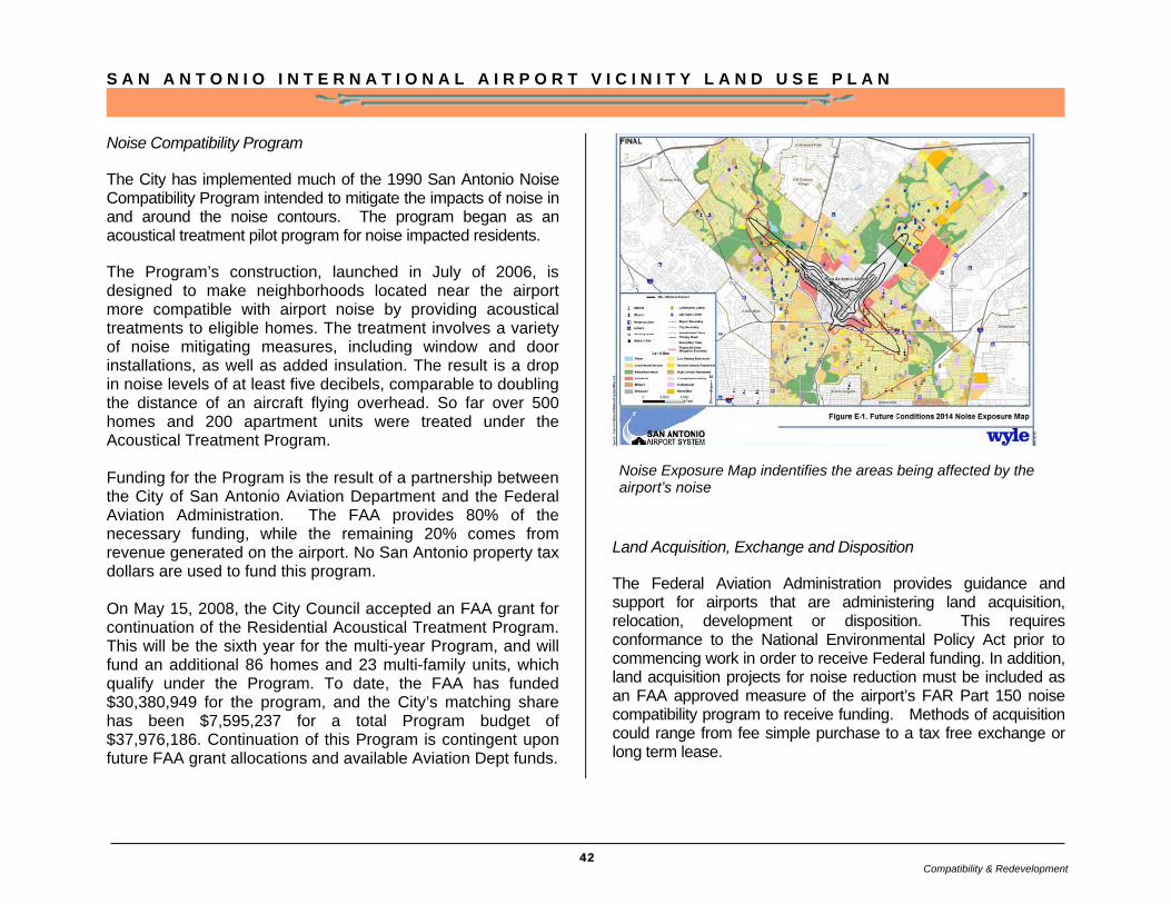
Noise Compatibility Program
The City has implemented much of the 1990 San Antonio Noise Compatibility Program intended to mitigate the impacts of noise in and around the noise contours. The program began as an acoustical treatment pilot program for noise impacted residents.
The Program’s construction, launched in July of 2006, is designed to make neighborhoods located near the airport more compatible with airport noise by providing acoustical treatments to eligible homes. The treatment involves a variety of noise mitigating measures, including window and door installations, as well as added insulation. The result is a drop in noise levels of at least five decibels, comparable to doubling the distance of an aircraft flying overhead. So far over 500 homes and 200 apartment units were treated under the Acoustical Treatment Program. Funding for the Program is the result of a partnership between the City of San Antonio Aviation Department and the Federal Aviation Administration. The FAA provides 80% of the necessary funding, while the remaining 20% comes from revenue generated on the airport. No San Antonio property tax dollars are used to fund this program. On May 15, 2008, the City Council accepted an FAA grant for continuation of the Residential Acoustical Treatment Program. This will be the sixth year for the multi-year Program, and will fund an additional 86 homes and 23 multi-family units, which qualify under the Program. To date, the FAA has funded $30,380,949 for the program, and the City’s matching share has been $7,595,237 for a total Program budget of $37,976,186. Continuation of this Program is contingent upon future FAA grant allocations and available Aviation Dept funds.
Land Acquisition, Exchange and Disposition
The Federal Aviation Administration provides guidance and support for airports that are administering land acquisition, relocation, development or disposition. This requires conformance to the National Environmental Policy Act prior to commencing work in order to receive Federal funding. In addition, land acquisition projects for noise reduction must be included as an FAA approved measure of the airport’s FAR Part 150 noise compatibility program to receive funding. Methods of acquisition could range from fee simple purchase to a tax free exchange or long term lease.
Noise Exposure Map indentifies the areas being affected by the airport’s noise
Compatibility & Redevelopment
S A N A N T O N I O I N T E R N A T I O N A L A I R P O R T V I C I N I T Y L A N D U S E P L A N
43
Compatibility & Redevelopment Goals and Objectives
Goal III: Encourage a unique experience for airport patrons by creating gateways and enhancing the airport vicinity’s image through urban design
Objective 3.1 Enhance the urban design of airport gateway areas through the creation of a corridor overlay district on US 281 and Loop 410
Objective 3.2 Continue development of Wurzbach Parkway as a major east-west connector
Goal IV: Develop a comprehensive set of development applications and incentives to implement the land use plan and continue noise attenuation efforts
Objective 4.1 Implement a zoning overlay ordinance to address noise attenuation for new construction within the noise contours
Objective 4.2 Ensure the review of public facilities that are proposed within the area of influence through an Aviation Department review process
Objective 4.3 Explore other mechanisms such as plat notes and avigation easements to provide airport area protections
Objective 4.4 Support commercial redevelopment through comprehensive rezoning and incentive zoning
Compatibility & Redevelopment
S A N A N T O N I O I N T E R N A T I O N A L A I R P O R T V I C I N I T Y L A N D U S E P L A N
44
Compatibility and Redevelopment Plan
Additional applications of land use management and redevelopment strategies can greatly enhance those tools that are currently in place. A combination of these programs would provide protections to airport operations, expand economic incentives to cultivate airfront uses, designate corridors and implement gateway image projects to enhance design of the airport’s entryways, and promote corridor redevelopment and transit oriented development.
Sound Attenuation Overlay District
The State’s Compatibility Guidelines can be enacted through an overlay district based on the DNL contours and specifying construction techniques to lower the noise levels experienced by occupants of the facility. Another method is to adopt performance standards that do not dictate the materials or method of construction, but that require lowering of noise levels to prescribed standards for various occupancy types. This overlay could also prohibit hazardous and incompatible uses in accordance with Federal and State regulations (see Table 1). A sound attenuation overlay district is currently proposed by for noise sensitive areas around Camp Bullis.
Restrictive Covenants/Avigation Easements
As property is acquired, the airport can impose land use restrictions and then re-market the parcels as airport compatible land. These are usually remainder parcels purchased through the Airport Land Acquisition Program. In addition avigation easements could be acquired or donated by property owners, acknowledging the property’s location within a noise contour.
Public Facilities Review
Proposed public facilities funded through capital improvement programs and bond programs should be reviewed to ensure land use compatibility.
Plat Notes & Publication of Noise Exposure Maps
All land within the DNL contours should carry a note on the subdivision plat so perspective buyers may gauge its appropriateness for the proposed use. A disclosure of noise impact areas to individuals and potential residents could become a requirement of real estate transactions. This should be accompanied by the publication of Noise Exposure Maps (NEM) identifying the airport’s present and future noise patterns.
Gateway Image and Corridor Overlay Districts
As a major hub of activity and a gateway to San Antonio, the airport provides the first impression of the City. Patrons should experience a unique sense of place representing the culture and heritage of the region as well as community pride displayed by an emphasis on design and character of the experience. One method is to enhance the airport image by increasing green space, introducing landscape design elements, and gateway entrance projects. A second strategy is the adoption of a corridor district to enhance the airport’s appearance and protect public investment. A distinctive theme could be implemented through design in development, landscaping, screening and signage regulations along the major corridors. Primary building materials could include masonry, stucco, hardiplank or cement fiberboard siding. The adoption of six corridor districts directly adjacent to
Compatibility & Redevelopment
S A N A N T O N I O I N T E R N A T I O N A L A I R P O R T V I C I N I T Y L A N D U S E P L A N
45
the airport is recommended to promote quality development and urban design:
• Loop 410 from Broadway to Jones Maltsberger
• US 281 from Nakoma to Sunset
• Wurzbach Pkwy from US281 to Perrin Beitel
• Jones-Maltsberger Rd from US281 to Cargo
• Sandau Rd from US281 to Cargo
• Airport Blvd from US281 to Terminal Dr
In addition to these roads and highways, key arterial streets could be designated as Metropolitan Corridor Overly Districts to enhance appearance and quality of construction:
• Perrin Beitel/Naco Perrin
• Walzem
• West Avenue
• Austin Highway
Economic Incentives
Airfront and business park development could be expanded by adding this type of development to the city’s available incentive program as well as promoting the Ad-valorem Tax Phase-In for potential location or expansion of aviation related industries. A
joint public/private airfront development program could entice new commercial, retail, aviation-related and business park development.
Comprehensive Rezoning/Incentive Zoning Districts
Existing high density residential uses ranging from 1350 ft. adjacent to and completely within the 65 DNL contour should be considered for comprehensive rezoning. The land use plan has provided designations for these properties that include commercial, mixed use, medium density and low density residential uses. As the life cycle of these apartment developments draws to a close, the multifamily use should be transitioned to a more compatible use that could be facilitated through a comprehensive rezoning.
The redevelopment of older corridors is essential to maintaining sustainable neighborhoods. As uses on corridors change over time, the original zoning for higher intensity uses can lead to an imbalance along a corridor where less intense neighborhood and community retail, office and services uses are necessary for neighborhood sustainability. As uses relocate, vacant industrial buildings can be converted for less intense commercial uses. Corridors often benefit from comprehensive rezoning to provide a balanced of commercial intensities. Corridors that would benefit from comprehensive rezoning include:
• Austin Highway
• Walzem Rd.
• Perrin Beitel/Naco Perrin
• West Avenue
Compatibility & Redevelopment

S A N A N T O N I O I N T E R N A T I O N A L A I R P O R T V I C I N I T Y L A N D U S E P L A N
46
The introduction of mixed use or “town centers” also recommended along major corridors. These centers shouldn’t be located 650 feet or closer to the 65 DNL contour. Commercial Retrofit is a Unified Development Code use pattern designed to encourage the redevelopment of existing shopping centers, big-box retail sites, and other sites characterized by large expanses of surface parking into a pedestrian friendly development. It allows mixed uses (residential above commercial) and certain zoning exemptions to encourage redevelopment. As the Commercial Retrofit use pattern has not been utilized since the UDC’s adoption, a reassessment of this provision is warranted to expand its potential applications for corridor redevelopment. Other applicable zoning districts include Mixed Use (MXD), Transit Oriented Development (TOD), and Form Based Zoning (FBZD).
Golf Zoning District
Recently the Golf zoning district was adopted by City Council to preserve areas where golf courses were integrated as part of a master development plan. Many of these courses are zoned as commercial or residential. The City should proceed to rezone the golf courses in and near the airport vicinity to preserve this beneficial use.
Transit Oriented Development
Transit oriented development (TOD) is located near rail stations or other high capacity transit areas and allows for a more intense and efficient use of land in a built-up environment that is oriented to pedestrians. TOD is typically located within one-half of a mile of a transit station, which is equivalent to a ten-minute walking distance. TOD projects range widely in size, from infill developments and mixed use centers to entire new communities. The Austin-San Antonio Commuter Rail line has planned a stop near the San Antonio International Airport. This presents a great opportunity to redevelop properties near the proposed stop as a mixed use development.
Austin -San Antonio Commuter Rail’s proposed route and station locations Courtesy: The Lone Star Rail District
Compatibility & Redevelopment
Left: Existing Golf Courses in and around the plan area
S A N A N T O N I O I N T E R N A T I O N A L A I R P O R T V I C I N I T Y L A N D U S E P L A N
47
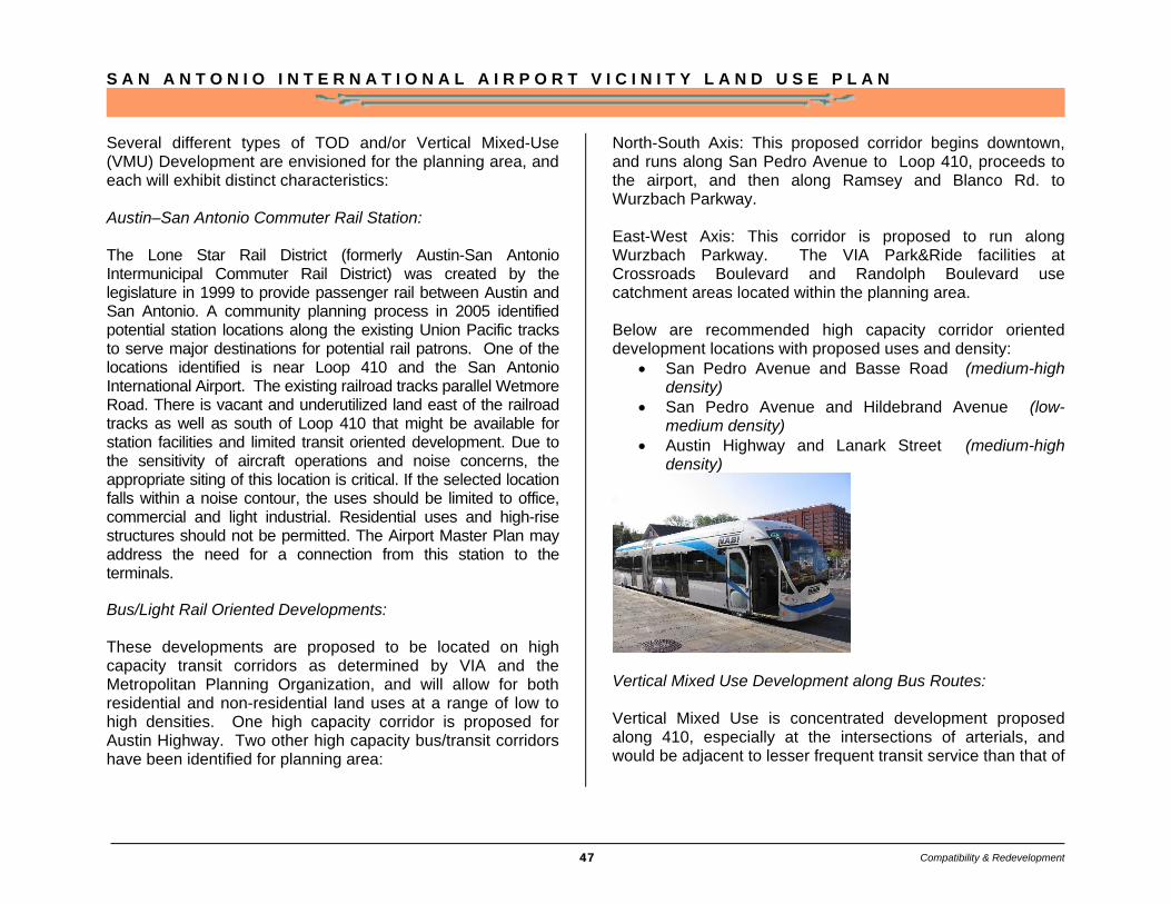
Several different types of TOD and/or Vertical Mixed-Use (VMU) Development are envisioned for the planning area, and each will exhibit distinct characteristics: Austin–San Antonio Commuter Rail Station: The Lone Star Rail District (formerly Austin-San Antonio Intermunicipal Commuter Rail District) was created by the legislature in 1999 to provide passenger rail between Austin and San Antonio. A community planning process in 2005 identified potential station locations along the existing Union Pacific tracks to serve major destinations for potential rail patrons. One of the locations identified is near Loop 410 and the San Antonio International Airport. The existing railroad tracks parallel Wetmore Road. There is vacant and underutilized land east of the railroad tracks as well as south of Loop 410 that might be available for station facilities and limited transit oriented development. Due to the sensitivity of aircraft operations and noise concerns, the appropriate siting of this location is critical. If the selected location falls within a noise contour, the uses should be limited to office, commercial and light industrial. Residential uses and high-rise structures should not be permitted. The Airport Master Plan may address the need for a connection from this station to the terminals.
Bus/Light Rail Oriented Developments: These developments are proposed to be located on high capacity transit corridors as determined by VIA and the Metropolitan Planning Organization, and will allow for both residential and non-residential land uses at a range of low to high densities. One high capacity corridor is proposed for Austin Highway. Two other high capacity bus/transit corridors have been identified for planning area:
North-South Axis: This proposed corridor begins downtown, and runs along San Pedro Avenue to Loop 410, proceeds to the airport, and then along Ramsey and Blanco Rd. to Wurzbach Parkway. East-West Axis: This corridor is proposed to run along Wurzbach Parkway. The VIA Park&Ride facilities at Crossroads Boulevard and Randolph Boulevard use catchment areas located within the planning area. Below are recommended high capacity corridor oriented development locations with proposed uses and density:
• San Pedro Avenue and Basse Road (medium-high density)
• San Pedro Avenue and Hildebrand Avenue (low-medium density)
• Austin Highway and Lanark Street (medium-high density)
Vertical Mixed Use Development along Bus Routes: Vertical Mixed Use is concentrated development proposed along 410, especially at the intersections of arterials, and would be adjacent to lesser frequent transit service than that of
Compatibility & Redevelopment

S A N A N T O N I O I N T E R N A T I O N A L A I R P O R T V I C I N I T Y L A N D U S E P L A N
48
a high-capacity corridor. Recommended VMU locations, with proposed uses and densities are:
• San Pedro Avenue and Loop 410 (residential / retail / services)
• Perrin-Beitel and Loop 410 (business/office/retail) • Village Drive and Loop 410 (retail/office/residential
services for the NE Baptist hospital area) • Jones Maltsberger and Loop 410, near the Airport
(business/office/retail oriented development catering to Airport patrons)
• West Avenue and Blanco Road, north of Loop 410 (neighborhood services)
Wurzbach Parkway
The completion of the Wurzbach Parkway, a vital east-west connector in the airport vicinity, will improve mobility and accessibility, while relieving traffic congestion on Loop 410 and Loop 1604. The parkway’s development was initiated in the late 1980’s as a means of relieving congestion in North San Antonio. The original environmental study was completed in 1992 and subsequently updated in 1995, 1998 and 2008. Following the
approval of the original study in 1992, TxDOT began purchasing Right of Way for the current alignment of the Parkway. Construction of the first phase - the section between Wetmore Road and Nacogdoches Road - was completed in 1996 as a joint initiative of the city and state. The section between Northwest Military Highway to Blanco Road was completed in 2002. Two portions of the Wurzbach Parkway, which have yet to be constructed, from Blanco Avenue to West Avenue and from Jones-Maltsberger to Wetmore, have been funded recently and the construction will start in 2010.
Above left: Image Illustrating route of Wurzbach Parkway Courtesy Alamo Regional Mobility Authority
Opposite page: Wurzbach Parkway east of Blanco Road with treed median and bike/hike path.
Below left: Wurzbach Parkway decorative median.
Compatibility & Redevelopment
S A N A N T O N I O I N T E R N A T I O N A L A I R P O R T V I C I N I T Y L A N D U S E P L A N
49
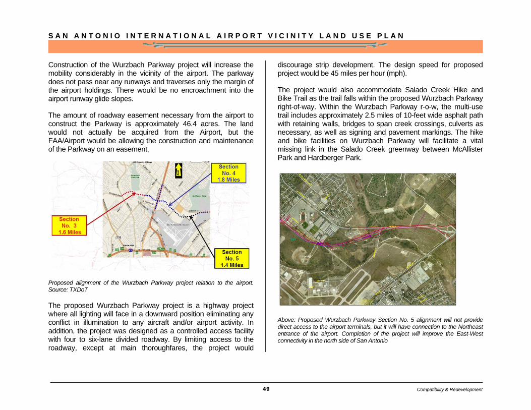
Construction of the Wurzbach Parkway project will increase the mobility considerably in the vicinity of the airport. The parkway does not pass near any runways and traverses only the margin of the airport holdings. There would be no encroachment into the airport runway glide slopes.
The amount of roadway easement necessary from the airport to construct the Parkway is approximately 46.4 acres. The land would not actually be acquired from the Airport, but the FAA/Airport would be allowing the construction and maintenance of the Parkway on an easement.
Proposed alignment of the Wurzbach Parkway project relation to the airport. Source: TXDoT
The proposed Wurzbach Parkway project is a highway project where all lighting will face in a downward position eliminating any conflict in illumination to any aircraft and/or airport activity. In addition, the project was designed as a controlled access facility with four to six-lane divided roadway. By limiting access to the roadway, except at main thoroughfares, the project would
discourage strip development. The design speed for proposed project would be 45 miles per hour (mph).
The project would also accommodate Salado Creek Hike and Bike Trail as the trail falls within the proposed Wurzbach Parkway right-of-way. Within the Wurzbach Parkway r-o-w, the multi-use trail includes approximately 2.5 miles of 10-feet wide asphalt path with retaining walls, bridges to span creek crossings, culverts as necessary, as well as signing and pavement markings. The hike and bike facilities on Wurzbach Parkway will facilitate a vital missing link in the Salado Creek greenway between McAllister Park and Hardberger Park.
Above: Proposed Wurzbach Parkway Section No. 5 alignment will not provide direct access to the airport terminals, but it will have connection to the Northeast entrance of the airport. Completion of the project will improve the East-West connectivity in the north side of San Antonio
Compatibility & Redevelopment
S A N A N T O N I O I N T E R N A T I O N A L A I R P O R T V I C I N I T Y L A N D U S E P L A N
50
Implementation
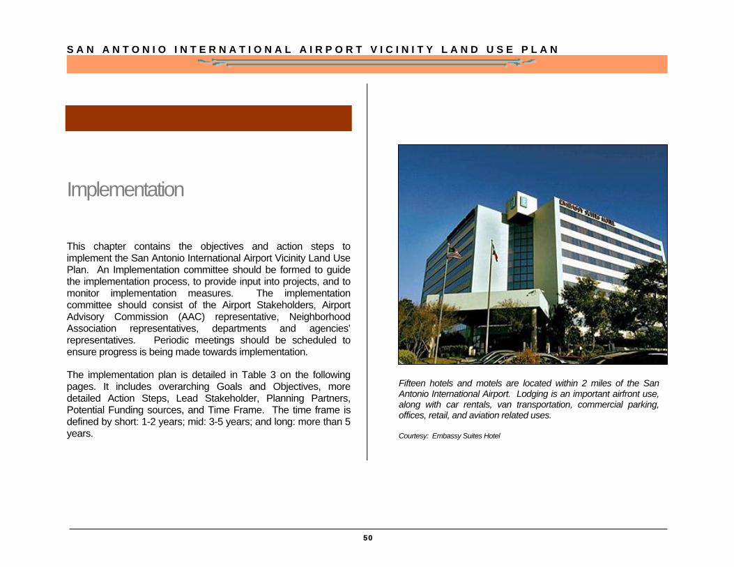
This chapter contains the objectives and action steps to implement the San Antonio International Airport Vicinity Land Use Plan. An Implementation committee should be formed to guide the implementation process, to provide input into projects, and to monitor implementation measures. The implementation committee should consist of the Airport Stakeholders, Airport Advisory Commission (AAC) representative, Neighborhood Association representatives, departments and agencies’ representatives. Periodic meetings should be scheduled to ensure progress is being made towards implementation.
The implementation plan is detailed in Table 3 on the following pages. It includes overarching Goals and Objectives, more detailed Action Steps, Lead Stakeholder, Planning Partners, Potential Funding sources, and Time Frame. The time frame is defined by short: 1-2 years; mid: 3-5 years; and long: more than 5 years.
Fifteen hotels and motels are located within 2 miles of the San Antonio International Airport. Lodging is an important airfront use, along with car rentals, van transportation, commercial parking, offices, retail, and aviation related uses.
Courtesy: Embassy Suites Hotel
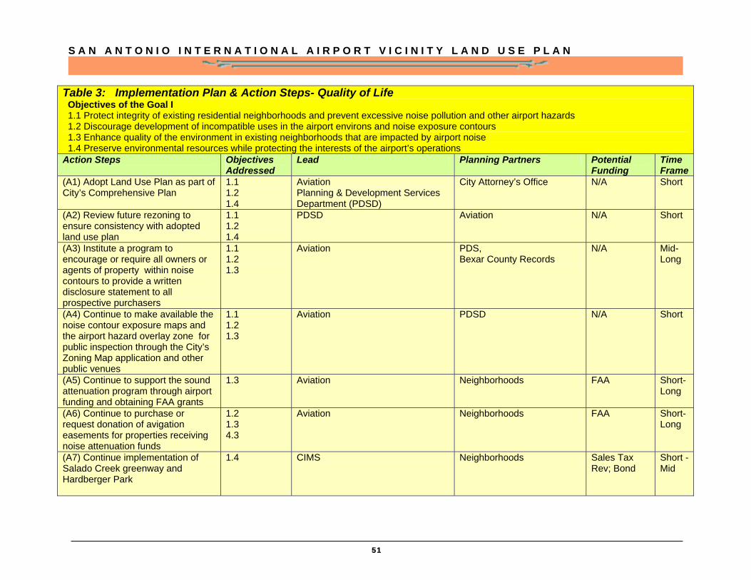
S A N A N T O N I O I N T E R N A T I O N A L A I R P O R T V I C I N I T Y L A N D U S E P L A N
51
Table 3: Implementation Plan & Action Steps- Quality of Life Objectives of the Goal I 1.1 Protect integrity of existing residential neighborhoods and prevent excessive noise pollution and other airport hazards 1.2 Discourage development of incompatible uses in the airport environs and noise exposure contours 1.3 Enhance quality of the environment in existing neighborhoods that are impacted by airport noise 1.4 Preserve environmental resources while protecting the interests of the airport’s operations Action Steps
Objectives Addressed
Lead Planning Partners Potential Funding
Time Frame
(A1) Adopt Land Use Plan as part of City’s Comprehensive Plan
1.1 1.2 1.4
Aviation Planning & Development Services Department (PDSD)
City Attorney’s Office N/A Short
(A2) Review future rezoning to ensure consistency with adopted land use plan
1.1 1.2 1.4
PDSD Aviation N/A Short
(A3) Institute a program to encourage or require all owners or agents of property within noise contours to provide a written disclosure statement to all prospective purchasers
1.1 1.2 1.3
Aviation PDS, Bexar County Records
N/A Mid-Long
(A4) Continue to make available the noise contour exposure maps and the airport hazard overlay zone for public inspection through the City’s Zoning Map application and other public venues
1.1 1.2 1.3
Aviation PDSD N/A Short
(A5) Continue to support the sound attenuation program through airport funding and obtaining FAA grants
1.3 Aviation Neighborhoods FAA Short-Long
(A6) Continue to purchase or request donation of avigation easements for properties receiving noise attenuation funds
1.2 1.3 4.3
Aviation Neighborhoods FAA Short-Long
(A7) Continue implementation of Salado Creek greenway and Hardberger Park
1.4 CIMS
Neighborhoods Sales Tax Rev; Bond
Short -Mid
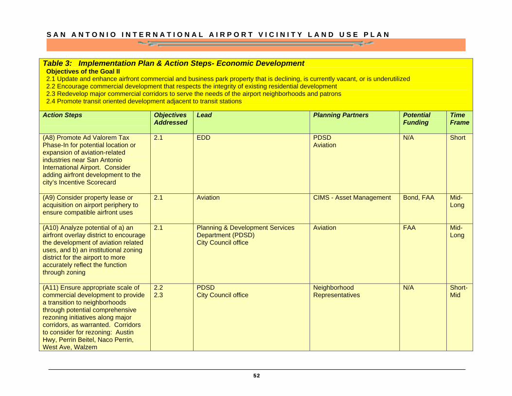
S A N A N T O N I O I N T E R N A T I O N A L A I R P O R T V I C I N I T Y L A N D U S E P L A N
52
Table 3: Implementation Plan & Action Steps- Economic Development Objectives of the Goal II 2.1 Update and enhance airfront commercial and business park property that is declining, is currently vacant, or is underutilized 2.2 Encourage commercial development that respects the integrity of existing residential development 2.3 Redevelop major commercial corridors to serve the needs of the airport neighborhoods and patrons 2.4 Promote transit oriented development adjacent to transit stations Action Steps
Objectives Addressed
Lead Planning Partners Potential Funding
Time Frame
(A8) Promote Ad Valorem Tax Phase-In for potential location or expansion of aviation-related industries near San Antonio International Airport. Consider adding airfront development to the city’s Incentive Scorecard
2.1
EDD PDSD Aviation
N/A Short
(A9) Consider property lease or acquisition on airport periphery to ensure compatible airfront uses
2.1
Aviation CIMS - Asset Management Bond, FAA Mid-Long
(A10) Analyze potential of a) an airfront overlay district to encourage the development of aviation related uses, and b) an institutional zoning district for the airport to more accurately reflect the function through zoning
2.1
Planning & Development Services Department (PDSD) City Council office
Aviation FAA Mid-Long
(A11) Ensure appropriate scale of commercial development to provide a transition to neighborhoods through potential comprehensive rezoning initiatives along major corridors, as warranted. Corridors to consider for rezoning: Austin Hwy, Perrin Beitel, Naco Perrin, West Ave, Walzem
2.2 2.3
PDSD City Council office
Neighborhood Representatives
N/A Short-Mid
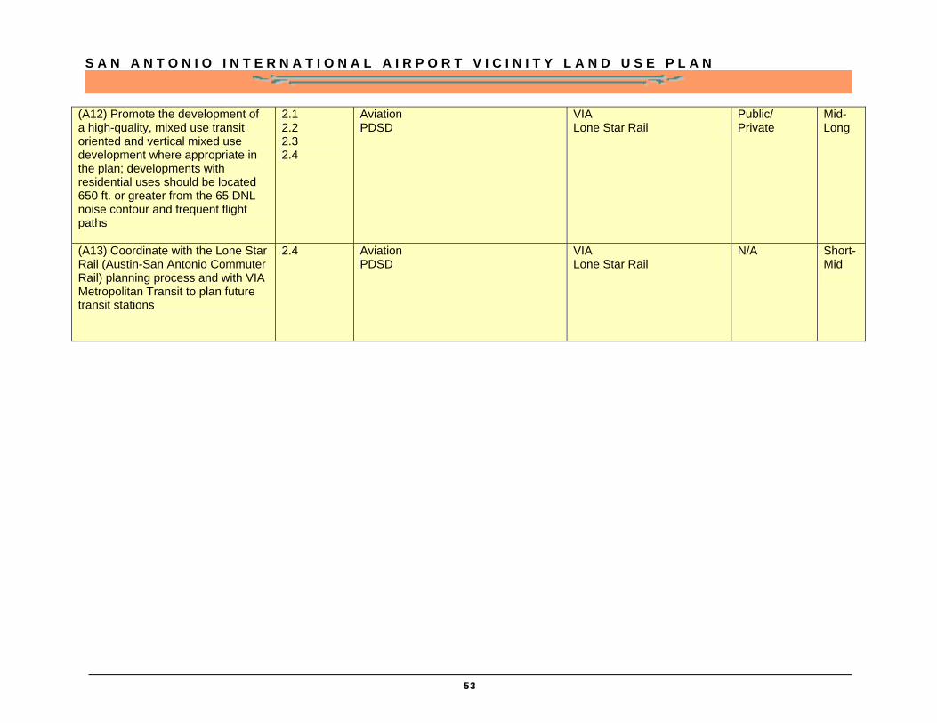
S A N A N T O N I O I N T E R N A T I O N A L A I R P O R T V I C I N I T Y L A N D U S E P L A N
53
(A12) Promote the development of a high-quality, mixed use transit oriented and vertical mixed use development where appropriate in the plan; developments with residential uses should be located 650 ft. or greater from the 65 DNL noise contour and frequent flight paths
2.1 2.2 2.3 2.4
Aviation PDSD
VIA Lone Star Rail
Public/ Private
Mid-Long
(A13) Coordinate with the Lone Star Rail (Austin-San Antonio Commuter Rail) planning process and with VIA Metropolitan Transit to plan future transit stations
2.4 Aviation PDSD
VIA Lone Star Rail
N/A Short-Mid
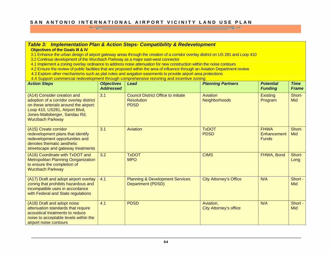
S A N A N T O N I O I N T E R N A T I O N A L A I R P O R T V I C I N I T Y L A N D U S E P L A N
54
Table 3: Implementation Plan & Action Steps- Compatibility & Redevelopment Objectives of the Goals III & IV 3.1 Enhance the urban design of airport gateway areas through the creation of a corridor overlay district on US 281 and Loop 410 3.2 Continue development of the Wurzbach Parkway as a major east-west connector
4.1 Implement a zoning overlay ordinance to address noise attenuation for new construction within the noise contours 4.2 Ensure the review of public facilities that are proposed within the area of influence through an Aviation Department review 4.3 Explore other mechanisms such as plat notes and avigation easements to provide airport area protections 4.4 Support commercial redevelopment through comprehensive rezoning and incentive zoning Action Steps Objectives
Addressed Lead Planning Partners Potential
Funding Time Frame
(A14) Consider creation and adoption of a corridor overlay district on these arterials around the airport: Loop 410, US281, Airport Blvd, Jones-Maltsberger, Sandau Rd, Wurzbach Parkway
3.1
Council District Office to initiate Resolution PDSD
Aviation Neighborhoods
Existing Program
Short-Mid
(A15) Create corridor redevelopment plans that identify redevelopment opportunities and denotes thematic aesthetic streetscape and gateway treatments
3.1 Aviation TxDOT PDSD
FHWA Enhancement Funds
Short-Mid
(A16) Coordinate with TxDOT and Metropolitan Planning Oorganization to ensure the completion of Wurzbach Parkway
3.2 TxDOT MPO
CIMS
FHWA, Bond Short-Long
(A17) Draft and adopt airport overlay zoning that prohibits hazardous and incompatible uses in accordance with Federal and State regulations
4.1 Planning & Development Services Department (PDSD)
City Attorney’s Office N/A Short -Mid
(A18) Draft and adopt noise attenuation standards that require acoustical treatments to reduce noise to acceptable levels within the airport noise contours
4.1
PDSD Aviation, City Attorney’s office
N/A Short -Mid
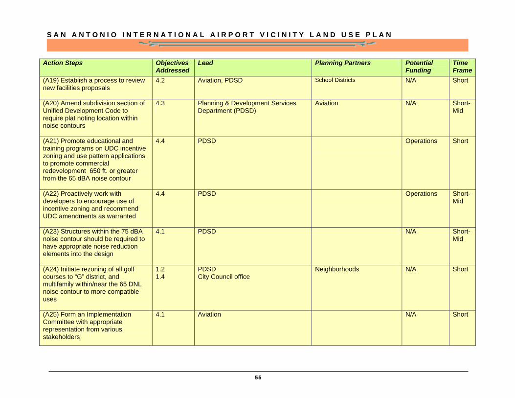
S A N A N T O N I O I N T E R N A T I O N A L A I R P O R T V I C I N I T Y L A N D U S E P L A N
55
Action Steps Objectives Addressed
Lead Planning Partners Potential Funding
Time Frame
(A19) Establish a process to review new facilities proposals
4.2 Aviation, PDSD School Districts N/A Short
(A20) Amend subdivision section of Unified Development Code to require plat noting location within noise contours
4.3
Planning & Development Services Department (PDSD)
Aviation N/A Short-Mid
(A21) Promote educational and training programs on UDC incentive zoning and use pattern applications to promote commercial redevelopment 650 ft. or greater from the 65 dBA noise contour
4.4 PDSD
Operations Short
(A22) Proactively work with developers to encourage use of incentive zoning and recommend UDC amendments as warranted
4.4 PDSD Operations Short-Mid
(A23) Structures within the 75 dBA noise contour should be required to have appropriate noise reduction elements into the design
4.1 PDSD N/A Short-Mid
(A24) Initiate rezoning of all golf courses to “G” district, and multifamily within/near the 65 DNL noise contour to more compatible uses
1.2 1.4
PDSD City Council office
Neighborhoods N/A Short
(A25) Form an Implementation Committee with appropriate representation from various stakeholders
4.1 Aviation N/A Short
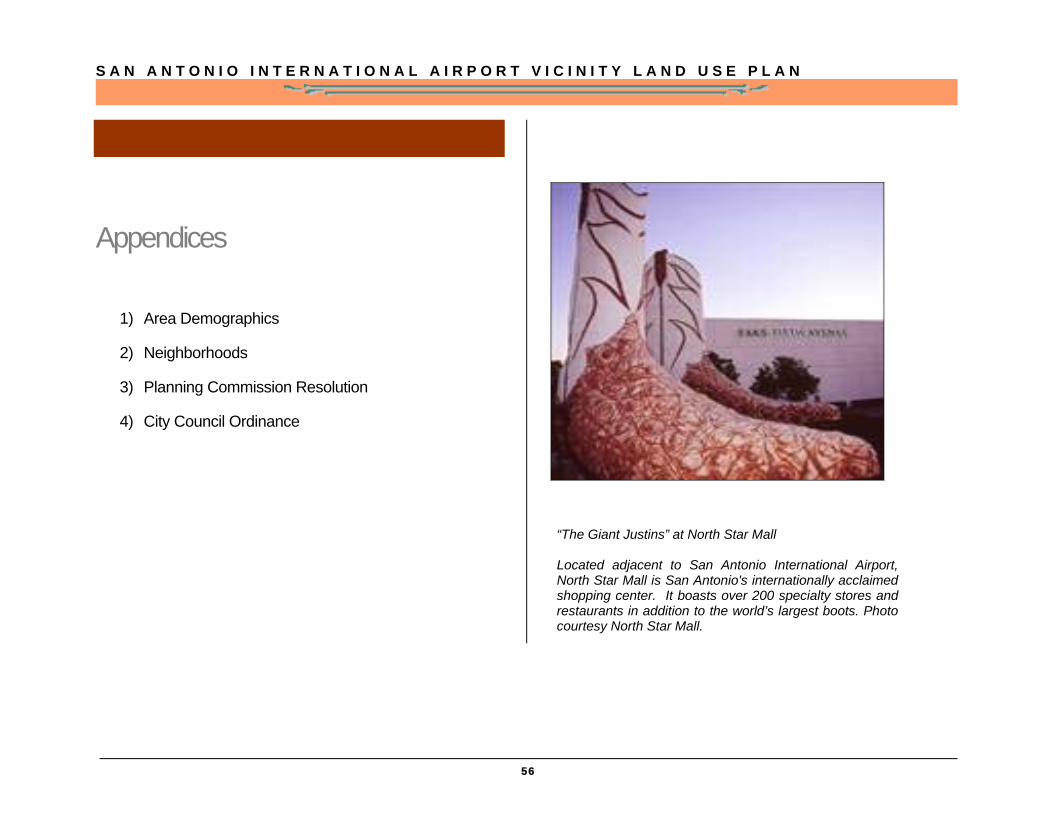
S A N A N T O N I O I N T E R N A T I O N A L A I R P O R T V I C I N I T Y L A N D U S E P L A N
56
Appendices
1) Area Demographics
2) Neighborhoods
3) Planning Commission Resolution
4) City Council Ordinance
“The Giant Justins” at North Star Mall Located adjacent to San Antonio International Airport, North Star Mall is San Antonio's internationally acclaimed shopping center. It boasts over 200 specialty stores and restaurants in addition to the world’s largest boots. Photo courtesy North Star Mall.

S A N A N T O N I O I N T E R N A T I O N A L A I R P O R T V I C I N I T Y L A N D U S E P L A N
57
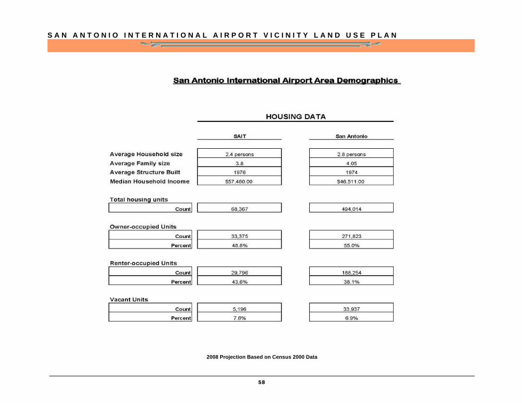
S A N A N T O N I O I N T E R N A T I O N A L A I R P O R T V I C I N I T Y L A N D U S E P L A N
58
2008 Projection Based on Census 2000 Data

S A N A N T O N I O I N T E R N A T I O N A L A I R P O R T V I C I N I T Y L A N D U S E P L A N
59
Neighborhoods
Northwest District Neighborhoods
Blanco Bluffs
Blanco Woods
Bluffview Greens
Bluffview of Camino Real
Bluffwood Estates of Camino Real
Brookwood Gardens
Camino Real
Canyon Creek Bluffs
Canyon Creek Village
Castle Forest
Castle Hills Forest
Castle Park
Castlewood Forest
Churchill Estates
Churchill Farms
Churchill Heights
Crownridge Park
Deerfield
Deer Hollow
Enchanted Village
Forest at Inwood
Gardens at Castle Hills
Georgian Oaks
Greater Harmony Hills
Heights
Heights II
Hidden Forest
Hunters Creek
Hunters Creek North
Inverness
Kingswood
Lockhill Estates
Mission Ridge
North Star Hill
Oak Glen Park
Oak Meadow
Park at Deerfield
Regency Park
Ridge at Deerfield
Salado Bluff Summerfield
Village at Inwood
Vista Del Norte of Camino Real
Walker Ranch
Warwick Farms
Waters at Deerfield
Voelcker Ranch
Airport District Neighborhoods
Arion Business Park
Beacon Circle Industrial Park
Beacon East Industrial
Villas of Bluff View
Perrin Beitel District Neighborhoods
Garden Court East
Oak Mont
Old Farm
Park North
Perrin Park
Sungate
The Hills
Village North

S A N A N T O N I O I N T E R N A T I O N A L A I R P O R T V I C I N I T Y L A N D U S E P L A N
60
Northeast District Neighborhoods
Blossom Park
Bluffcreek
Briarwick
Burning Tree
Churchill Bluffs
Classen Ridge
Countryside
Eden
Eden Roc
El Chaparral
El Dorado
El Dorado Hills
Hidden Oaks North
Hills
Hunters Mill
Fall Creek
Fertile Valley
Green Spring Valley
Knoll Creek
Longs Creek
Meadow Wood North
Northern Hills
Oak View Heights
Oak Ridge Village
Old Farm
Parknorth
Parkside
Pepperidge
Preston Hollow
Redland Oaks
Redland Ranch
Redland Ranch at Elm Creek
Redland Springs
Scattered Oaks
Skyline
St. James Place
Stoneridge
Thousand Oaks Forest
Valencia
Village at Knoll Creek
Southeast District Neighborhoods
East Terrell Hills
East Terrell Hills Heights
Fairfield
Forest Oak
Merrymont
North Alamo Heights
Northeast Park
Oak Mont
Oak Grove
Oakwell Farms
Perrin Park
Raven Estates
Terrell Park
Town Lake
Village North One
Willshire Terrace
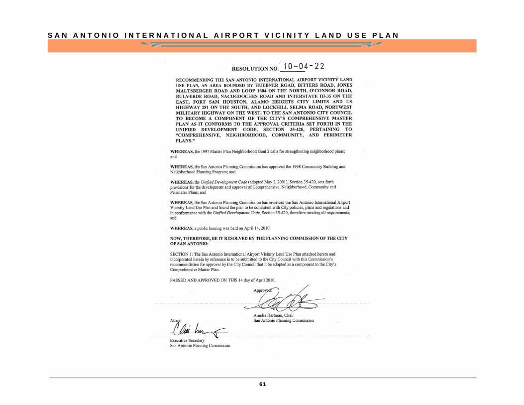
S A N A N T O N I O I N T E R N A T I O N A L A I R P O R T V I C I N I T Y L A N D U S E P L A N
61
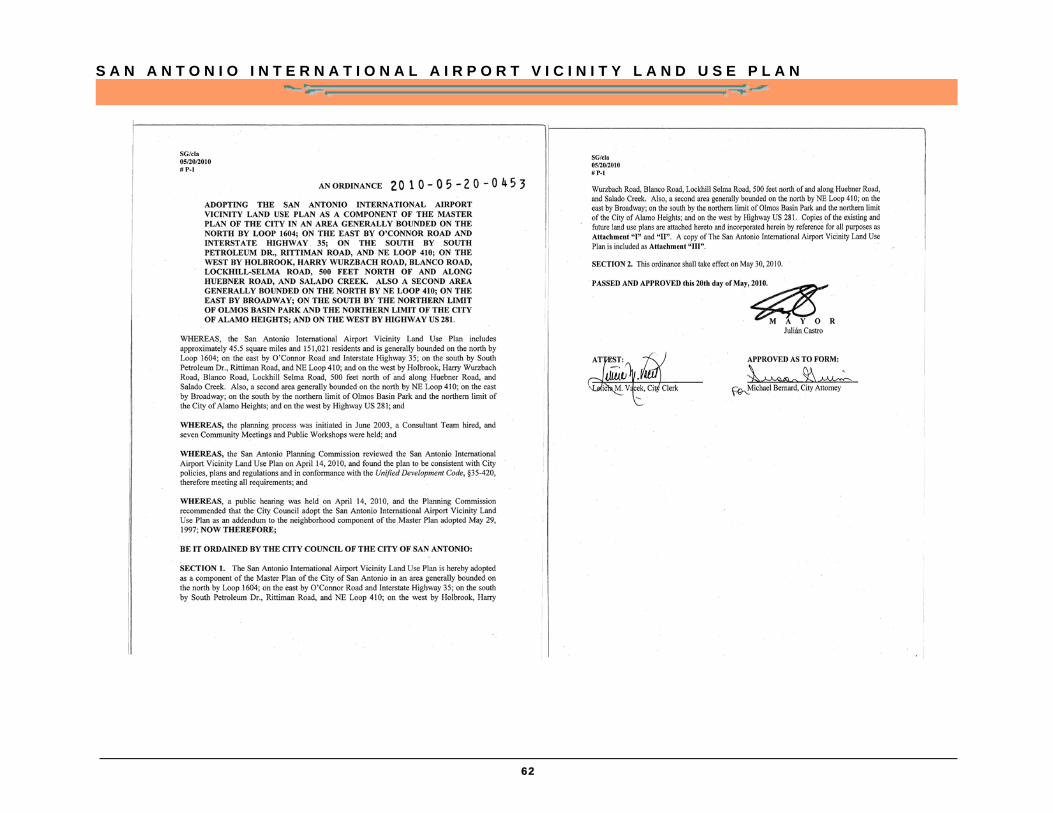
S A N A N T O N I O I N T E R N A T I O N A L A I R P O R T V I C I N I T Y L A N D U S E P L A N
62