Embed Size (px)
Citation preview
San Francisco Bay Area Earthquake Readiness Response: Concept of Operations Plan Interim
September 23, 2008
U.S. Department of Homeland Security
Federal Emergency Management Agency Region IX
California Governor’s Office of Emergency Services
PUBLIC VERSION

iii
SAN FRANCISCO BAY AREA EARTHQUAKE READINESS RESPONSE: CONCEPT OF OPERATIONS PLAN
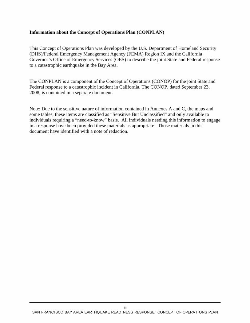
Information about the Concept of Operations Plan (CONPLAN)
This Concept of Operations Plan was developed by the U.S. Department of Homeland Security (DHS)/Federal Emergency Management Agency (FEMA) Region IX and the California Governor’s Office of Emergency Services (OES) to describe the joint State and Federal response to a catastrophic earthquake in the Bay Area.
The CONPLAN is a component of the Concept of Operations (CONOP) for the joint State and Federal response to a catastrophic incident in California. The CONOP, dated September 23, 2008, is contained in a separate document.
Note: Due to the sensitive nature of information contained in Annexes A and C, the maps and some tables, these items are classified as “Sensitive But Unclassified” and only available to individuals requiring a “need-to-know” basis. All individuals needing this information to engage in a response have been provided these materials as appropriate. Those materials in this document have identified with a note of redaction.
iv
SAN FRANCISCO BAY AREA EARTHQUAKE READINESS RESPONSE: CONCEPT OF OPERATIONS PLAN
C ONTE NTS San Francisco Bay Area Earthquake Readiness Response: Concept of Operations Plan ...... i Acronyms ...................................................................................................................................... vi Acronyms in Annex C, Tab 3 (Emergency Communications) ...................................................x
1 Overview .......................................................................................................................... 1-1 1.1 Introduction .......................................................................................................... 1-1 1.2 Acknowledgements .............................................................................................. 1-1 1.3 Scope and Applicability ....................................................................................... 1-3
1.3.1 Scope of Operations ............................................................................ 1-3 1.3.2 Authorities and Guidance .................................................................... 1-3
1.4 Organization of the Concept Plan ........................................................................ 1-4 2 Situation ........................................................................................................................... 2-1
2.1 Geographic Scope ................................................................................................ 2-1 2.2 Threats and Hazards ............................................................................................. 2-1 2.3 Assumptions ......................................................................................................... 2-3 2.4 Local and State Capabilities and Unmet Needs ................................................... 2-4
3 Mission ............................................................................................................................. 3-1 4 Execution ......................................................................................................................... 4-1
4.1 Senior Leaders’ Intent .......................................................................................... 4-1 4.2 Concept of Operations (CONOP) ........................................................................ 4-1
4.2.1 General Sequence of Response ........................................................... 4-1 4.2.2 Activation ............................................................................................ 4-2 4.2.3 Response Strategy ............................................................................... 4-3 4.2.4 Objectives for Response ...................................................................... 4-4 4.2.5 Courses of Action (COAs) .................................................................. 4-6 4.2.6 Execution Schedule ............................................................................. 4-6
5 Incident Coordination ...................................................................................................... 5-1 5.1 Coordination ........................................................................................................ 5-1
5.1.1 Coordination with Other State and Federal Agencies ......................... 5-1 5.1.2 Coordination with Local and Regional Governments ......................... 5-2 5.1.3 Coordination of State and Federal Military Resources ....................... 5-3 5.1.4 Coordination with Tribal Governments .............................................. 5-3 5.1.5 Coordination with Other States ........................................................... 5-4
5.2 Communication .................................................................................................... 5-4 5.2.1 Emergency Communications .............................................................. 5-4 5.2.2 Intelligence and Information Sharing Protocols .................................. 5-4 5.2.3 External Communications ................................................................... 5-4
5.3 Oversight .............................................................................................................. 5-5 5.3.1 Field-Level Response .......................................................................... 5-5
v
SAN FRANCISCO BAY AREA EARTHQUAKE READINESS RESPONSE: CONCEPT OF OPERATIONS PLAN
5.3.2 Local Governments ............................................................................. 5-5 5.3.3 Operational Areas ................................................................................ 5-5 5.3.4 Region ................................................................................................. 5-6 5.3.5 State .................................................................................................... 5-6 5.3.6 Federal ................................................................................................. 5-6 5.3.7 Unified Coordination Group ............................................................... 5-6 5.3.8 Military Resources .............................................................................. 5-7
6 Plan Maintenance ............................................................................................................. 6-1 Annex A: Incident Task Organization and Coordination .................................................... A-1 Annex B: Intelligence and Situational Awareness ..................................................................B-1
B.1 Potential Sources of Information .....................................................................................B-1 B.2 Intelligence Collection and Utilization ............................................................................B-2 B.3 Essential Elements of Information (EEIs) .......................................................................B-3
Annex C: Operations .............................................................................................................. C-13
T AB L E S 1. Local, regional, State, Federal, and private-sector entities that participated in the development of the San Francisco Bay Area Earthquake Concept Plan or provided information or comments (not including members of the Steering Committee) ......................... 1-1
2a. Courses of Action for the objectives during the immediate impact phase, E to E+72 hours ............................................................................................................................................. 4-7
2b. Courses of Action for the objectives during the sustained response phase, E 72 hours to E + 14 days ............................................................................................................................ 4-14
2c. Courses of Action for the objectives during the relief phase, E + 14 days to E + 60 days ............................................................................................................................................ 4-20
B-1. Essential Elements of Information, methodology/source, responsible entity, products, and timeline ..................................................................................................................B-4
vi
SAN FRANCISCO BAY AREA EARTHQUAKE READINESS RESPONSE: CONCEPT OF OPERATIONS PLAN
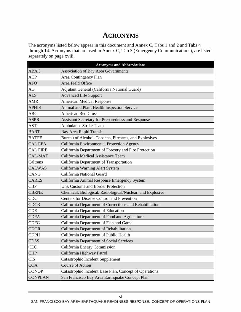
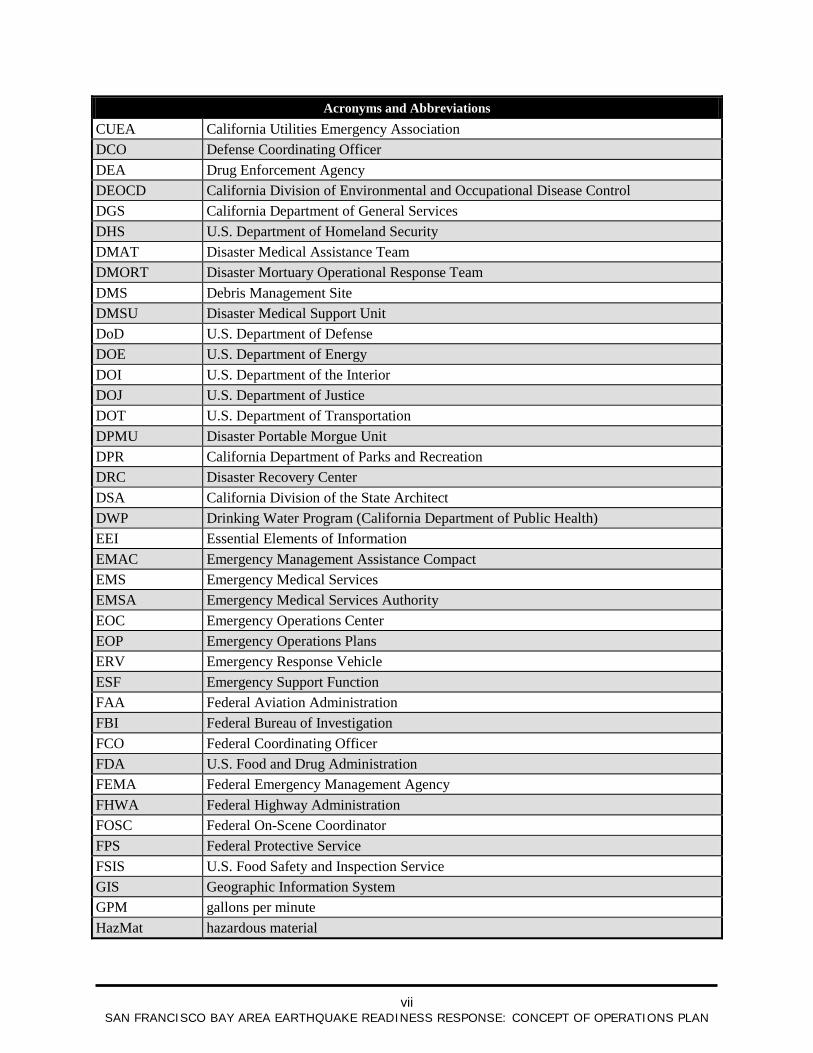
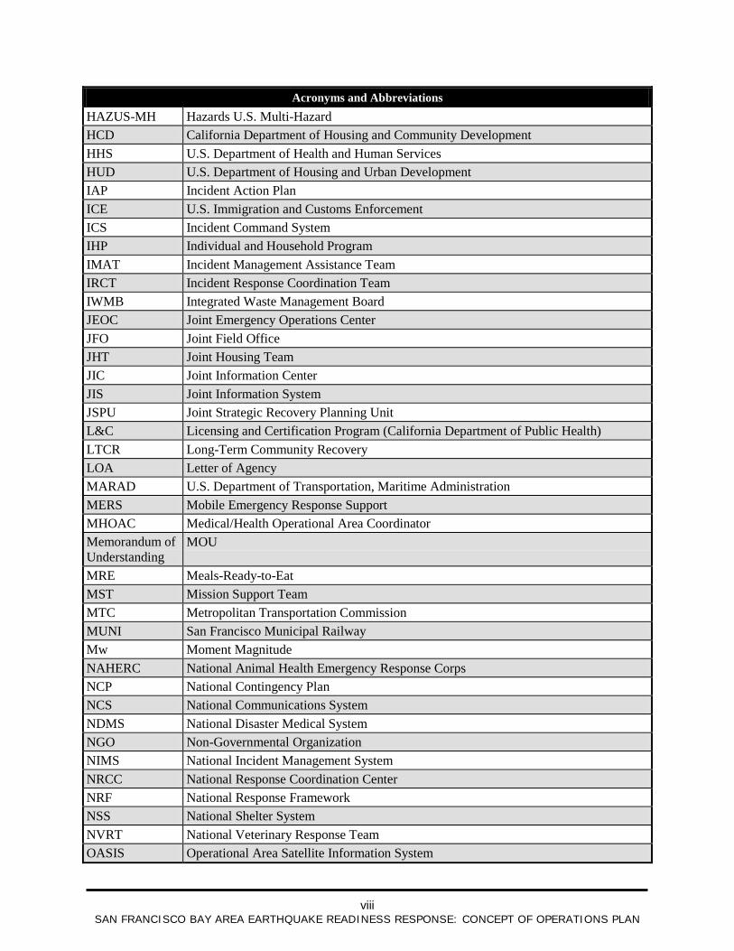
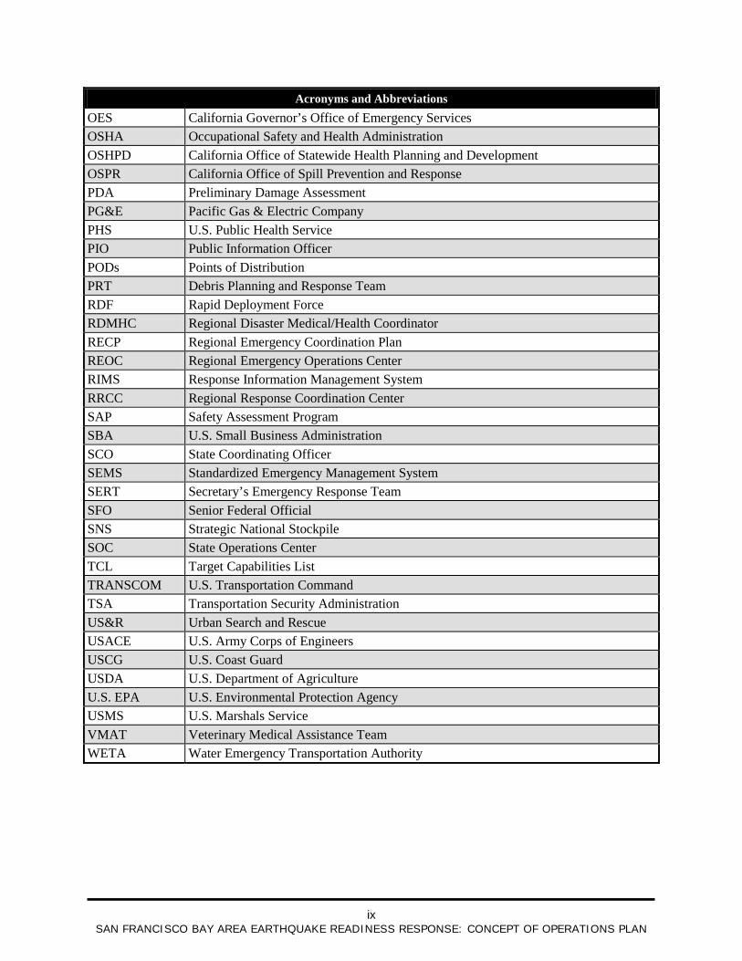
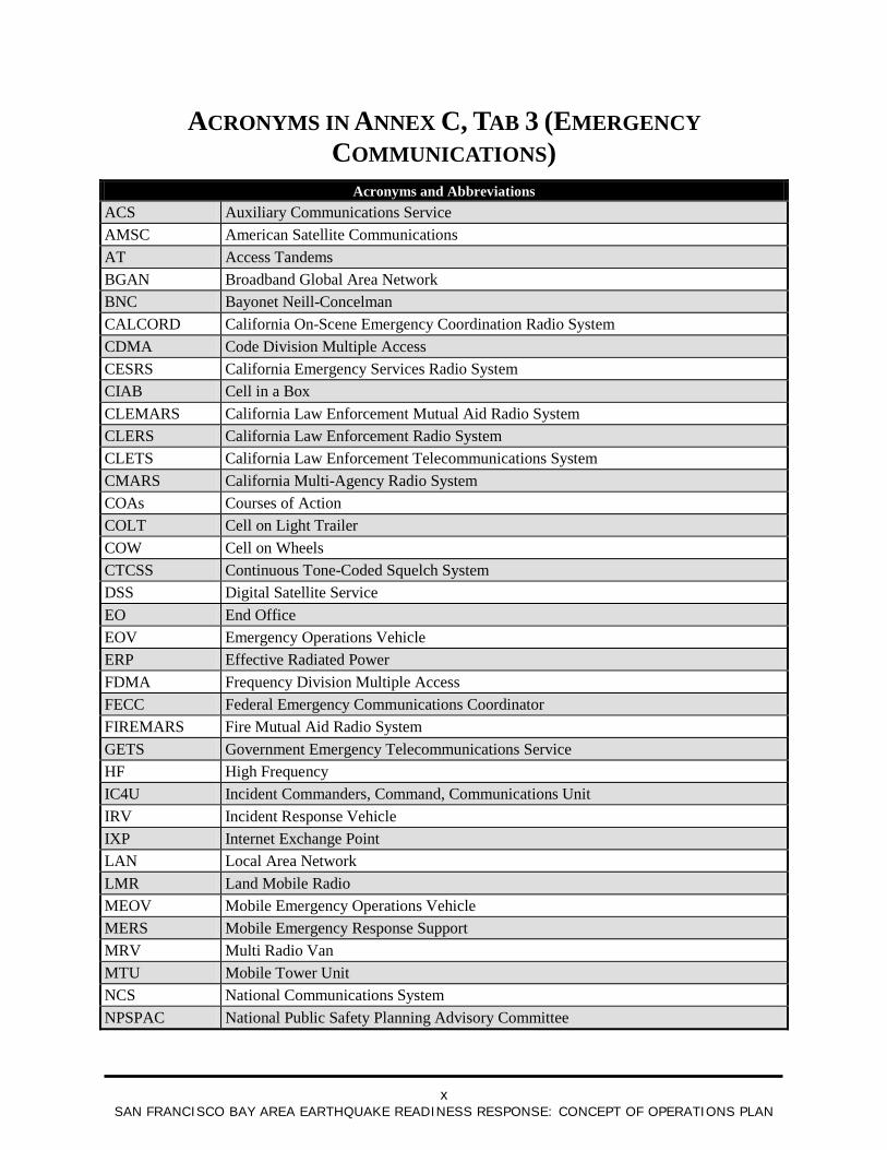
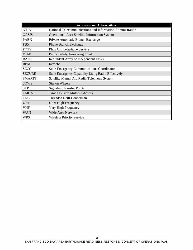
ACRONYMS The acronyms listed below appear in this document and Annex C, Tabs 1 and 2 and Tabs 4 through 14. Acronyms that are used in Annex C, Tab 3 (Emergency Communications), are listed separately on page xviii.
Acronyms and Abbreviations ABAG Association of Bay Area Governments ACP Area Contingency Plan AFO Area Field Office AG Adjutant General (California National Guard) ALS Advanced Life Support AMR American Medical Response APHIS Animal and Plant Health Inspection Service ARC American Red Cross ASPR Assistant Secretary for Preparedness and Response AST Ambulance Strike Team BART Bay Area Rapid Transit BATFE Bureau of Alcohol, Tobacco, Firearms, and Explosives CAL EPA California Environmental Protection Agency CAL FIRE California Department of Forestry and Fire Protection CAL-MAT California Medical Assistance Team Caltrans California Department of Transportation CALWAS California Warning Alert System CANG California National Guard CARES California Animal Response Emergency System CBP U.S. Customs and Border Protection CBRNE Chemical, Biological, Radiological/Nuclear, and Explosive CDC Centers for Disease Control and Prevention CDCR California Department of Corrections and Rehabilitation CDE California Department of Education CDFA California Department of Food and Agriculture CDFG California Department of Fish and Game CDOR California Department of Rehabilitation CDPH California Department of Public Health CDSS California Department of Social Services CEC California Energy Commission CHP California Highway Patrol CIS Catastrophic Incident Supplement COA Course of Action CONOP Catastrophic Incident Base Plan, Concept of Operations CONPLAN San Francisco Bay Area Earthquake Concept Plan
vii
SAN FRANCISCO BAY AREA EARTHQUAKE READINESS RESPONSE: CONCEPT OF OPERATIONS PLAN
Acronyms and Abbreviations CUEA California Utilities Emergency Association DCO Defense Coordinating Officer DEA Drug Enforcement Agency DEOCD California Division of Environmental and Occupational Disease Control DGS California Department of General Services DHS U.S. Department of Homeland Security DMAT Disaster Medical Assistance Team DMORT Disaster Mortuary Operational Response Team DMS Debris Management Site DMSU Disaster Medical Support Unit DoD U.S. Department of Defense DOE U.S. Department of Energy DOI U.S. Department of the Interior DOJ U.S. Department of Justice DOT U.S. Department of Transportation DPMU Disaster Portable Morgue Unit DPR California Department of Parks and Recreation DRC Disaster Recovery Center DSA California Division of the State Architect DWP Drinking Water Program (California Department of Public Health) EEI Essential Elements of Information EMAC Emergency Management Assistance Compact EMS Emergency Medical Services EMSA Emergency Medical Services Authority EOC Emergency Operations Center EOP Emergency Operations Plans ERV Emergency Response Vehicle ESF Emergency Support Function FAA Federal Aviation Administration FBI Federal Bureau of Investigation FCO Federal Coordinating Officer FDA U.S. Food and Drug Administration FEMA Federal Emergency Management Agency FHWA Federal Highway Administration FOSC Federal On-Scene Coordinator FPS Federal Protective Service FSIS U.S. Food Safety and Inspection Service GIS Geographic Information System GPM gallons per minute HazMat hazardous material
viii
SAN FRANCISCO BAY AREA EARTHQUAKE READINESS RESPONSE: CONCEPT OF OPERATIONS PLAN
Acronyms and Abbreviations HAZUS-MH Hazards U.S. Multi-Hazard HCD California Department of Housing and Community Development HHS U.S. Department of Health and Human Services HUD U.S. Department of Housing and Urban Development IAP Incident Action Plan ICE U.S. Immigration and Customs Enforcement ICS Incident Command System IHP Individual and Household Program IMAT Incident Management Assistance Team IRCT Incident Response Coordination Team IWMB Integrated Waste Management Board JEOC Joint Emergency Operations Center JFO Joint Field Office JHT Joint Housing Team JIC Joint Information Center JIS Joint Information System JSPU Joint Strategic Recovery Planning Unit L&C Licensing and Certification Program (California Department of Public Health) LTCR Long-Term Community Recovery LOA Letter of Agency MARAD U.S. Department of Transportation, Maritime Administration MERS Mobile Emergency Response Support MHOAC Medical/Health Operational Area Coordinator Memorandum of Understanding
MOU
MRE Meals-Ready-to-Eat MST Mission Support Team MTC Metropolitan Transportation Commission MUNI San Francisco Municipal Railway Mw Moment Magnitude NAHERC National Animal Health Emergency Response Corps NCP National Contingency Plan NCS National Communications System NDMS National Disaster Medical System NGO Non-Governmental Organization NIMS National Incident Management System NRCC National Response Coordination Center NRF National Response Framework NSS National Shelter System NVRT National Veterinary Response Team OASIS Operational Area Satellite Information System
ix
SAN FRANCISCO BAY AREA EARTHQUAKE READINESS RESPONSE: CONCEPT OF OPERATIONS PLAN
Acronyms and Abbreviations OES California Governor’s Office of Emergency Services OSHA Occupational Safety and Health Administration OSHPD California Office of Statewide Health Planning and Development OSPR California Office of Spill Prevention and Response PDA Preliminary Damage Assessment PG&E Pacific Gas & Electric Company PHS U.S. Public Health Service PIO Public Information Officer PODs Points of Distribution PRT Debris Planning and Response Team RDF Rapid Deployment Force RDMHC Regional Disaster Medical/Health Coordinator RECP Regional Emergency Coordination Plan REOC Regional Emergency Operations Center RIMS Response Information Management System RRCC Regional Response Coordination Center SAP Safety Assessment Program SBA U.S. Small Business Administration SCO State Coordinating Officer SEMS Standardized Emergency Management System SERT Secretary’s Emergency Response Team SFO Senior Federal Official SNS Strategic National Stockpile SOC State Operations Center TCL Target Capabilities List TRANSCOM U.S. Transportation Command TSA Transportation Security Administration US&R Urban Search and Rescue USACE U.S. Army Corps of Engineers USCG U.S. Coast Guard USDA U.S. Department of Agriculture U.S. EPA U.S. Environmental Protection Agency USMS U.S. Marshals Service VMAT Veterinary Medical Assistance Team WETA Water Emergency Transportation Authority
x
SAN FRANCISCO BAY AREA EARTHQUAKE READINESS RESPONSE: CONCEPT OF OPERATIONS PLAN
ACRONYMS IN ANNEX C, TAB 3 (EMERGENCY COMMUNICATIONS)
Acronyms and Abbreviations ACS Auxiliary Communications Service AMSC American Satellite Communications AT Access Tandems BGAN Broadband Global Area Network BNC Bayonet Neill-Concelman CALCORD California On-Scene Emergency Coordination Radio System CDMA Code Division Multiple Access CESRS California Emergency Services Radio System CIAB Cell in a Box CLEMARS California Law Enforcement Mutual Aid Radio System CLERS California Law Enforcement Radio System CLETS California Law Enforcement Telecommunications System CMARS California Multi-Agency Radio System COAs Courses of Action COLT Cell on Light Trailer COW Cell on Wheels CTCSS Continuous Tone-Coded Squelch System DSS Digital Satellite Service EO End Office EOV Emergency Operations Vehicle ERP Effective Radiated Power FDMA Frequency Division Multiple Access FECC Federal Emergency Communications Coordinator FIREMARS Fire Mutual Aid Radio System GETS Government Emergency Telecommunications Service HF High Frequency IC4U Incident Commanders, Command, Communications Unit IRV Incident Response Vehicle IXP Internet Exchange Point LAN Local Area Network LMR Land Mobile Radio MEOV Mobile Emergency Operations Vehicle MERS Mobile Emergency Response Support MRV Multi Radio Van MTU Mobile Tower Unit NCS National Communications System NPSPAC National Public Safety Planning Advisory Committee
xi
SAN FRANCISCO BAY AREA EARTHQUAKE READINESS RESPONSE: CONCEPT OF OPERATIONS PLAN
Acronyms and Abbreviations NTIA National Telecommunications and Information Administration OASIS Operational Area Satellite Information System PABX Private Automatic Branch Exchange PBX Phone Branch Exchange POTS Plain Old Telephone Service PSAP Public Safety Answering Point RAID Redundant Array of Independent Disks REM Remote SECC State Emergency Communications Coordinator SECURE State Emergency Capability Using Radio Effectively SMARTS Satellite Mutual Aid Radio/Telephone System SOWS Site on Wheels STP Signaling Transfer Points TMDA Time Division Multiple Access TNC Threaded Neill-Concelman UHF Ultra High Frequency VHF Very High Frequency WAN Wide Area Network WPS Wireless Priority Service

xii
SAN FRANCISCO BAY AREA EARTHQUAKE READINESS RESPONSE: CONCEPT OF OPERATIONS PLAN
This page is intentionally left blank.
1-1
SAN FRANCISCO BAY AREA EARTHQUAKE READINESS RESPONSE: CONCEPT OF OPERATIONS PLAN
1 Overview
1.1 Introduction This document, the San Francisco Bay Area Earthquake Readiness Response: Concept of Operations Plan (CONPLAN), describes the joint State and Federal response to a catastrophic earthquake in the Bay Area. The CONPLAN contains:
Projected impacts of the earthquake Objectives, Courses of Action (COAs), and Decision Points Response capabilities Response actions that can or will be taken
This document was prepared in accordance with the U.S. Department of Homeland Security (DHS) National Planning and Execution System through a collaborative effort by the Federal Emergency Management Agency (FEMA) and the California Governor’s Office of Emergency Services (OES).
The CONPLAN is a component of the Concept of Operations (CONOP) for the joint State and Federal response to a catastrophic incident in California. The CONOP, dated September 23, 2008, is contained in a separate document.
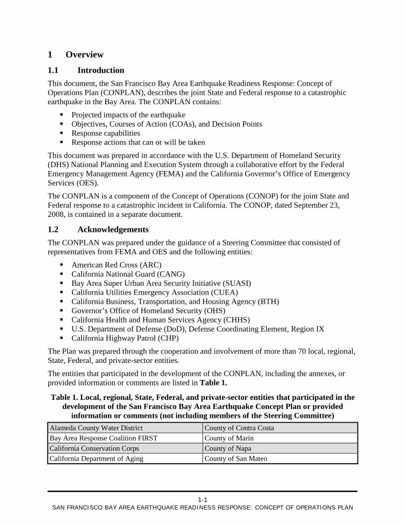
1.2 Acknowledgements The CONPLAN was prepared under the guidance of a Steering Committee that consisted of representatives from FEMA and OES and the following entities:
American Red Cross (ARC) California National Guard (CANG) Bay Area Super Urban Area Security Initiative (SUASI) California Utilities Emergency Association (CUEA) California Business, Transportation, and Housing Agency (BTH) Governor’s Office of Homeland Security (OHS) California Health and Human Services Agency (CHHS) U.S. Department of Defense (DoD), Defense Coordinating Element, Region IX California Highway Patrol (CHP)
The Plan was prepared through the cooperation and involvement of more than 70 local, regional, State, Federal, and private-sector entities.
The entities that participated in the development of the CONPLAN, including the annexes, or provided information or comments are listed in Table 1.
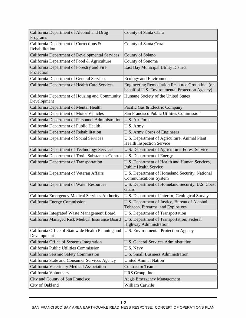
Table 1. Local, regional, State, Federal, and private-sector entities that participated in the development of the San Francisco Bay Area Earthquake Concept Plan or provided
information or comments (not including members of the Steering Committee) Alameda County Water District County of Contra Costa Bay Area Response Coalition FIRST County of Marin California Conservation Corps County of Napa California Department of Aging County of San Mateo
1-2
SAN FRANCISCO BAY AREA EARTHQUAKE READINESS RESPONSE: CONCEPT OF OPERATIONS PLAN
California Department of Alcohol and Drug Programs
County of Santa Clara
California Department of Corrections & Rehabilitation
County of Santa Cruz
California Department of Developmental Services County of Solano California Department of Food & Agriculture County of Sonoma California Department of Forestry and Fire Protection
East Bay Municipal Utility District
California Department of General Services Ecology and Environment California Department of Health Care Services Engineering Remediation Resource Group Inc. (on
behalf of U.S. Environmental Protection Agency) California Department of Housing and Community Development
Humane Society of the United States
California Department of Mental Health Pacific Gas & Electric Company California Department of Motor Vehicles San Francisco Public Utilities Commission California Department of Personnel Administration U.S. Air Force California Department of Public Health U.S. Army California Department of Rehabilitation U.S. Army Corps of Engineers California Department of Social Services U.S. Department of Agriculture, Animal Plant
Health Inspection Service California Department of Technology Services U.S. Department of Agriculture, Forest Service California Department of Toxic Substances Control U.S. Department of Energy California Department of Transportation U.S. Department of Health and Human Services,
Public Health Service California Department of Veteran Affairs U.S. Department of Homeland Security, National
Communications System California Department of Water Resources U.S. Department of Homeland Security, U.S. Coast
Guard California Emergency Medical Services Authority U.S. Department of Interior, Geological Survey California Energy Commission U.S. Department of Justice, Bureau of Alcohol,
Tobacco, Firearms, and Explosives California Integrated Waste Management Board U.S. Department of Transportation California Managed Risk Medical Insurance Board U.S. Department of Transportation, Federal
Highway Administration California Office of Statewide Health Planning and Development
U.S. Environmental Protection Agency
California Office of Systems Integration U.S. General Services Administration California Public Utilities Commission U.S. Navy California Seismic Safety Commission U.S. Small Business Administration California State and Consumer Services Agency United Animal Nation California Veterinary Medical Association Contractor Team: California Volunteers URS Group, Inc. City and County of San Francisco Aegis Emergency Management City of Oakland William Carwile
1-3
SAN FRANCISCO BAY AREA EARTHQUAKE READINESS RESPONSE: CONCEPT OF OPERATIONS PLAN
City of Palo Alto Dewberry & Davis LLC City of San Jose Richard Eisner Code 3 Associates Robert Latham County of Alameda Medical Planning Resources
1.3 Scope and Applicability The CONPLAN was developed for a catastrophic earthquake along the San Andreas fault in Northern California, but the CONOP and the resources needed for the response are applicable to any catastrophic earthquake in the Bay Area. The scope and applicability of the CONPLAN are described below. While potential earthquakes of different magnitudes or along other faults, such as the Hayward Fault, may have greater impact in areas that would not be severely affected by the San Andreas fault incident, the general requirements for response and resources on a regional level would be similar.
1.3.1 Scope of Operations The CONPLAN describes the scope of work for the joint response of the State and Federal governments and supporting entities such as voluntary agencies. The operations, established under a Unified Coordination Group1
The CONPLAN is designed to be used by emergency managers at all levels in the Bay Area. It is also intended to support elected officials at the local, State, and Federal levels of government by providing the mechanisms to engage with disaster response and management officials in making informed and effective decisions. Additionally, the CONPLAN serves as a reference for senior State and Federal officials and their agencies in providing support to the incident in a coordinated manner.
using principles of Unified Command, will be undertaken in support of the direct response of local, State, regional, tribal, and private-sector entities. The CONPLAN does not describe the specific response efforts of these entities, but it does describe the resources that will be deployed by the Federal Government. The CONPLAN does not address tactics.
1.3.2 Authorities and Guidance The CONOP contains a list of authorities and guidance that are applicable to the CONPLAN. The CONPLAN is consistent with the principles of the National Incident Management System (NIMS) and will be implemented in accordance with the National Response Framework (NRF), the State of California Emergency Plan, and the Standardized Emergency Management System (SEMS). In particular, Federal actions described in the CONPLAN will be implemented in support of local, State, regional, tribal, and private-sector entities, which have responsibility for the public safety, health, and welfare within their jurisdictions.
1 See the CONOP and Annex A of this document for information about the Unified Coordination Group.
1-4
SAN FRANCISCO BAY AREA EARTHQUAKE READINESS RESPONSE: CONCEPT OF OPERATIONS PLAN
1.4 Organization of the Concept Plan The CONPLAN consists of a Base Plan and three annexes. The Base Plan is designed to provide broad guidance and includes:
Predicted impacts of a Moment Magnitude (Mw) 7.7 to 7.9 earthquake on the San Andreas fault
Mission of the joint State/Federal organization
Objectives, which are decision points for response, and associated COAs
A schedule of actions, referred to as the Execution Schedule, that can or will be implemented
Annex A contains detailed information on incident-response organization.1
Annex B describes the types of information that are essential and the plan for collecting the information.
Annex C contains planning and operational execution in the 14 functional areas listed below.
Animal care Debris management Emergency communications External affairs Facilities and infrastructure Firefighting, urban search and rescue, and hazardous materials response Law enforcement and public safety Mass care and shelter Mass fatality Medical response Public health Stabilization and recovery Temporary housing Transportation and logistics
The Execution Schedule, presented in Section 4.2.6 on page 4-38, integrates elements of the functional areas that pertain to deployment of Federal resources.
1 Due to the sensitive nature of information contained in Annexes A and C, the maps and some tables, these items are classified as
“Sensitive But Unclassified” and only available to individuals requiring a “need-to-know” basis. All individuals needing this information to engage in a response have been provided these materials as appropriate.
2-1
SAN FRANCISCO BAY AREA EARTHQUAKE READINESS RESPONSE: CONCEPT OF OPERATIONS PLAN
2 Situation The CONPLAN is based on the threat posed by a recurrence of the Mw 7.7 to 7.9 earthquake that occurred in 1906 on the San Andreas fault, under current population and land use conditions. The scenario for this incident was developed by the U.S. Geological Survey (USGS) and others using FEMA’s HAZUS-MH
1
2.1 Geographic Scope
loss estimation program.
The CONPLAN focuses on the Bay Area’s 10 counties, which are listed below and shown in Map 1.2
Alameda
Contra Costa Marin Napa San Francisco
Santa Clara Santa Cruz San Mateo Solano Sonoma
These counties will bear significant impacts directly or from regional disruption of critical infrastructure systems and short- and long-term impacts to the economy. Adjacent counties, such as Mendocino and San Benito, may sustain damage and require response. Counties such as Sacramento, San Joaquin, and Stanislaus in the Central Valley may be affected immediately by evacuations and other response actions. An earthquake of this magnitude will also have significant effects in the rest of California and the Nation.
2.2 Threats and Hazards The characteristics of the earthquake used in the development of the scenario are:
The scenario earthquake occurs in January at 1400 Pacific Standard Time on a weekday. The month and the time of the scenario earthquake were changed from those in the 1906 earthquake to maximize the potential impact on structures and individuals.
Similar to the 1906 event, a foreshock precedes the earthquake, followed approximately 20 to 25 seconds later by the main shock, which lasts 45 to 60 seconds.
The earthquake’s epicenter is just outside the mouth of the San Francisco Bay.
The earthquake ruptures the San Andreas fault for approximately 300 miles from the San Juan Bautista area in the south to the Mendocino Triple Junction in the north.
The earthquake has an estimated Mw of 7.7 to 7.9 with an instrumental intensity of VIII (severe shaking/moderate to heavy damage) to IX (violent shaking/heavy damage) in widespread areas of the most severely affected counties. Pockets within the affected counties experience instrument intensity of X (extreme shaking/very heavy damage), particularly areas immediately adjacent to the fault and areas where liquefaction is likely to occur.
1 The HAZUS analysis and resulting scenario are described in FEMA, Catastrophic Incident Earthquake Scenario, 2007. 2 Maps are available in supplementary material.
2-2
SAN FRANCISCO BAY AREA EARTHQUAKE READINESS RESPONSE: CONCEPT OF OPERATIONS PLAN
Damage will be catastrophic in the areas that experience shaking intensities of IX and X and high or very high liquefaction (i.e., areas adjacent to the fault in Marin, San Francisco, San Mateo, Santa Clara, Santa Cruz, and Sonoma Counties) and in areas of high or very high liquefaction. Map 2 shows the levels of shaking intensity expected as a result of the earthquake. Map 3 displays regional liquefaction zones.
Shaking is felt as far north as Oregon, south to Los Angeles, and east to central Nevada.
Ground shaking and damage are expected in 19 California counties, extending from Monterey County in the south to Humboldt County in the north, and into the San Joaquin Valley.
Catastrophic damage is expected in Alameda, Marin, San Francisco, San Mateo, Santa Clara, Santa Cruz, and Sonoma Counties and in the urban areas of Oakland, San Francisco, San Jose, and cities in San Mateo County.
Threats and hazards resulting from shaking, faulting, and liquefaction include:
− Structural and nonstructural damage to buildings and infrastructure, including widespread collapse of buildings
− Widespread ignition of fires − Subsidence and loss of soil-bearing capacity, particularly in areas of liquefaction − Displacement along faults − Widespread occurrence of landslides − Hazardous materials spills and incidents − Dam/levee failure resulting in flooding
Threats and hazards resulting from the main shock will be aggravated or recur during aftershocks, which will continue for months after the main shock.
Despite the earthquake’s magnitude, it is not expected to generate a tsunami or a seiche.
The major impacts of the earthquake that are expected in the 10 counties of the Bay Area are as follows:1
More than 500 fire ignitions
Up to 50 million tons of debris created Number of households without potable water service:
− Day 1: 1,828,000 − Day 7: 1,279,00 − Day 30: 256,000
Number of households without electric power: − Day 1: 789,000 − Day 7: 229,000 − Day 30: 59,000
1 In general, these estimates are based on HAZUS analyses performed by the USGS and others. Refer to the document entitled “Catastrophic Earthquake Incident Scenario,” dated September 20, 2007, for additional information regarding the sources of these estimates and for estimates by county. Estimates for displaced individuals and people requiring emergency shelter have been adjusted to reflect ARC data prepared using ARC’s December 2007 Northern California Earthquake Concept of Operations and other sources. ARC estimates that the peak demand for care and shelter resources will occur between Days 7 and 10.
2-3
SAN FRANCISCO BAY AREA EARTHQUAKE READINESS RESPONSE: CONCEPT OF OPERATIONS PLAN
Number, magnitude, and probability of aftershocks − 33 to 59 aftershocks of Mw >5—100% probability − 1 to 10 aftershocks of Mw >6—100% probability − 1 aftershock of Mw >7—50% probability
1,300 miles of road closures 600 bridges destroyed and 320 severely damaged 115,000 residential destroyed or damaged extensively 10,000 commercial buildings destroyed or damaged extensively 12,300 people with serious injuries 1,700 people trapped and requiring rescue 3,300 fatalities 650,000 displaced individuals (assuming an average of 2.7 persons per household) Number of people requiring emergency shelter:
− Day 1 to 7: 330,000 − Day 15: 125,000 to 165,000
100,000 animals requiring shelter
Scenario data and assumptions are presented in Annex C, Tabs 1 to 14.
2.3 Assumptions The following general assumptions pertain to the CONPLAN. Assumptions that pertain to functional areas are listed in Annex C, Tabs 1 to 14. The Governor immediately proclaims a State of Emergency and requests that the
President declare a disaster.
The President immediately declares a Major Disaster, making Federal assistance available under the Robert T. Stafford Disaster Relief and Emergency Assistance Act (the Stafford Act).
DHS and FEMA immediately implement the Catastrophic Incident Supplement (CIS) to the NRF and begin mobilizing Federal resources. The quantities identified in the CIS will not meet the requirements outlined in the CONPLAN and listed in Table 2.
The OES Regional Emergency Operations Center (REOC) for the Coastal Region is not functional; its functions are immediately assumed by the State Operations Center (SOC) according to OES CONOP.
FEMA Region IX Regional Response Coordination Center (RRCC) in Oakland is not functional. In accordance with the CONOP, FEMA collocates with OES at the SOC.
All Operational Area Emergency Operations Centers (EOCs) in the affected area experience varying levels of damage and are understaffed but are at least partly operational. All other local government functions in the affected area are severely compromised or focused entirely on response to the earthquake.
On a statewide basis, all elements of SEMS, including communications and mutual aid systems, are functional.
The earthquake is so severe that:
2-4
SAN FRANCISCO BAY AREA EARTHQUAKE READINESS RESPONSE: CONCEPT OF OPERATIONS PLAN
− The response capabilities and resources of the local jurisdictions and the State are insufficient, overwhelmed, and exhausted.
− The hardest hit areas (such as San Francisco and coastal communities) are initially isolated from re-supply by fixed-wing air, ground, and sea transportation.
− The number of casualties and/or displaced persons is large, possibly in the tens to hundreds of thousands.
− Massive disruption of the area’s critical infrastructure (such as energy, transportation, telecommunications, and public health and medical systems) occurs.
− Significant shortage of response and casualty/evacuee reception capabilities, equipment, and medical care occurs.
Resources under the direct control of the State of California are maximized and augmented by Federal resources.
Upon receipt of the Presidential declaration or Presidential order to commit Federal resources, the State and Federal governments establish joint operations (described in Annex A) to provide assistance to local jurisdictions.
2.4 Local and State Capabilities and Unmet Needs As part of the development of the CONPLAN, FEMA identified the local and regional capabilities in the Bay Area that are likely to be needed after a catastrophic earthquake. Projected major unmet needs were also identified.
The capabilities, which are summarized below and organized according to the DHS Target Capabilities List (TCL), were identified at the Operational Area level.1
Planning. All Operational Areas have Emergency Operations Plans (EOPs), in compliance with requirements under SEMS. OES Coastal Region has a Regional Emergency Coordination Plan to guide coordination and resource allocation at the regional level.
See Annex C for more specific information about local and State capabilities.
Communications. Local emergency communications systems will be compromised, but redundancies within State systems should provide sufficient capability for continued communication on a regional basis. Basic commercial communication systems, especially those relying on cable, will suffer the most damage.
Onsite Incident Management. Local capabilities for onsite incident management are robust and generally well-organized but will be challenged by the scope and magnitude of the incident, damage to transportation infrastructure, and communications difficulties. Mutual aid and State resources will supplement local resources with Incident Management Teams, but deployment of these teams will be adversely affected by damage to transportation infrastructure.
1 The assessment included the Operational Area lead agencies for the 10 counties included in the CONPLAN, plus the cities of Oakland and San Jose. It does not reflect specific capabilities of other individual cities.
2-5
SAN FRANCISCO BAY AREA EARTHQUAKE READINESS RESPONSE: CONCEPT OF OPERATIONS PLAN
EOC Management. All Operational Areas have EOCs that should survive the earthquake but may suffer degradation of functionality from secondary impacts.
Critical Resource Logistics and Distribution. Approximately 2.2 million1
Volunteer Management and Donations. Some jurisdictions, such as San Francisco, have developed plans for integrating volunteer resources and managing donations. The Bay Area SUASI has developed a regional system that can be adapted by individual jurisdictions to manage volunteer resources.
people will require feeding and other commodities due to lack of services, loss of residence, or the fact that they are visitors or commuters who are stranded. Existing stockpiles of critical commodities are limited. Supply by contractors and distribution will be severely compromised by overwhelming need and damage to transportation infrastructure. Some Operational Areas and local governments have identified staging areas and other support locations, but this information is not formally documented in plans on a consistent basis.
Responder Safety and Health. Environmental degradation is likely to occur, resulting in significant physical hazards, and civil unrest may ensue. Both will make responder health and safety a concern and will delay or disrupt response operations.
Public Safety and Security Response. Local and State Region II law enforcement mutual aid resources will not be sufficient to meet immediate needs. (The area that Region II covers is shown in Figure A-1). Statewide mutual aid (more than 80,000 sworn personnel) and CANG will provide resources but will have difficulty reaching hardest hit areas initially due to damage to transportation infrastructure. Duration of public safety and security requirements (several months) will necessitate replacement of responders from other jurisdictions.
Animal Health Emergency Support. Local public and nongovernmental resources for animal care will be overwhelmed by requirements for sheltering as many as 100,000 animals, including companion animals that accompany evacuees who are seeking shelter and animals that are abandoned and require rescue. In major farming/ranching areas such as Contra Costa, Marin, Napa, Santa Clara, Solano, and Sonoma Counties, a major need for evacuation and sheltering of livestock is not anticipated, but disruptions to power, water, and transportation systems may adversely affect livestock operations.
Environmental Health. Hazardous materials incidents will be numerous, particularly in heavy industrial areas such as western Contra Costa County. Additionally, lack of water and sanitation due to system damage will result in emerging public health crises in the hardest hit areas (Marin, San Francisco, San Mateo, Santa Clara, Santa Cruz). Most of the locally stored water supplies in tanks and small reservoirs will be depleted within 48 to 72 hours for fire, medical, and other critical services.
1 This figure derives from American Red Cross estimates of approximately 40 percent of individuals in the affected area (5,600,000
people) will require services during the initial days following the incident.

2-6
SAN FRANCISCO BAY AREA EARTHQUAKE READINESS RESPONSE: CONCEPT OF OPERATIONS PLAN
Firefighting Operations and Support. More than 500 fires are likely to be ignited in the aftermath of the earthquake. Local and mutual aid Region II fire/rescue resources will not be sufficient to meet immediate needs due to the number of ignitions and rescue missions and damage to infrastructure. Statewide mutual aid will provide resources but will have difficulty reaching hardest hit areas initially due to damage to transportation infrastructure. Fires may burn for extended periods.
Citizen Protection: Evacuation, In-place Protection. Local evacuations will be required due to fires, hazardous materials incidents, and emerging public health emergencies due to lack of water and sanitation. It is possible that the scenario earthquake will cause one or more dams to lose structural integrity or to fail, resulting in the need to evacuate people from the floodplain below. Local authorities, supplemented by State law enforcement, will have sufficient resources for command/control, but resources will be required for traffic control, transportation, and sheltering of evacuees. Evacuation operations will be adversely affected by damage to transportation infrastructure, including roads, bridges, airports, and port facilities. See Annex C, Tab 14, for a description of the condition of transportation infrastructure that may be used for evacuation routes.
Urban Search and Rescue (US&R). More than 1,700 people are expected to be trapped in collapsed buildings and require rescue. Thousands more may be stranded in damaged buildings such as high-rises. Mutual aid resources in Region II will not be sufficient to meet the required number of rescue missions, nor will Federal US&R resources in California be adequate. Resources from other regions will be provided through the Fire and Rescue Mutual Aid system but will have difficulty reaching hardest hit areas initially due to damage to transportation infrastructure. Damage to high-rise buildings in downtown areas may result in extensive search and rescue efforts.
Emergency Public Information and Warning. Several jurisdictions, including San Francisco, have citywide public warning systems, but these systems may be disrupted by the earthquake. The Bay Area Emergency Public Information Network provides an informal, pre-incident network for coordination among public information officers (PIOs). Private-sector media resources in the Bay Area, such as television and radio stations, are extensive.
Triage and Pre-hospital Treatment. Approximately 55,500 people will require medical treatment; of those, 12,500 will require hospitalization and 43,000 will not. Emergency Medical Services (EMS) resources within fire departments will be devoted to firefighting and rescue missions. Damage to transportation infrastructure will limit the influx of resources and movement of victims. On-hand medical supplies will be exhausted within 48 hours. Many individuals will not have access to medical treatment during the first 72 hours after the earthquake.
2-7
SAN FRANCISCO BAY AREA EARTHQUAKE READINESS RESPONSE: CONCEPT OF OPERATIONS PLAN
Medical Surge. Hospitals and other healthcare facilities in the hardest hit areas will suffer major structural damage, severely limiting treatment capabilities. Healthcare facility operations will be further affected by limited (24-hour) supply of generator fuel and lack of water. Damage to transportation infrastructure will limit influx of medical personnel, and resources and evacuation of patients, although hospitals in less severely impacted areas and outlying counties will be able to take patients. As much as 80 percent of the hospital beds in the 10 counties may not be available due to damage to buildings and support infrastructure.
Medical Supplies Management and Distribution. Local hospitals and other health-care facilities will immediately experience shortages of supplies due to demand and relatively limited onsite inventories. The medical treatment facilities typically carry 2 days of supplies. Re-supply will be limited by damage to transportation infrastructure.
Mass Care. The National Shelter System database lists more than 1,100 emergency shelters in the Bay Area with a combined capacity to house more than 150,000 displaced individuals. However, it is estimated that approximately 50 percent of shelters will be unavailable initially due to structural damage and cleanup requirements. Given that more than 300,000 people may require shelter at the peak, there will be a significant shortfall in actual shelter capacity.
Fatality Management. HAZUS estimates the number of fatalities at 3,300. Local coroner/medical examiner resources and resources available through mutual aid in Region II will be overwhelmed by the number of fatalities and the requirements for transportation, storage, identification, and coordination with families, both immediately and over the long term. Resources from other regions will be deployed through the Coroners Mutual Aid system but will have difficulty reaching the affected area due to damage to infrastructure.
Structural Damage and Assessment. Local public works departments and contractor resources will not be sufficient to meet immediate demand for emergency debris removal or for establishing sites for staging, reduction, and recycling. Up to 50 million tons of debris, consisting of building materials, personal property, and sediment will be generated by the earthquake. Demolition of damaged structures will continue to create high demand for contractor resources as recovery proceeds. Similarly, public and contractor assessment/inspection resources will be overwhelmed and dependent on engineers/inspectors from outside the region for rapid assessments of structural damage to critical facilities, infrastructure, housing, and commercial structures. Deployment of Safety Assessment Program (SAP) volunteers from other regions will be delayed by damage to transportation infrastructure.
Restoration of Lifelines. Lifelines are defined as water, wastewater, power, natural gas, telecommunication, fuel distribution, and transportation systems. Power restoration is likely to be relatively rapid in all but the hardest hit areas. Major water and sewer facilities will require significant repairs. Damage to distribution (water) and collection (sewer) systems may take months, requiring temporary systems.
2-8
SAN FRANCISCO BAY AREA EARTHQUAKE READINESS RESPONSE: CONCEPT OF OPERATIONS PLAN
The Hetch-Hetchy water system delivers water to 2.4 million people in the Bay Area. If the system is damaged, the time required for temporary repairs to various facilities to restore partial service ranges is as follows:
− Pump stations: 2 days − Water treatment plants: 3 to 6 days − Storage tanks: 25 to 30 days − Tunnels: 30 to 60 days − Pipelines: up to 40 days
Other water systems supplying the North and East Bay counties face similar failure and restoration times.
Shutdown of, and damage to, petroleum refining, pipeline, storage, and distribution systems will create an immediate shortage of fuel, including fuel for ground transportation, air transportation, and generators. In general, local governments do not have extensive supplies of fuel for sustained operations.
Major transportation links may take 2 or more years to repair. The following estimated damage is expected:
− As many as 42 failures of key freeway sections are anticipated throughout the region. The majority of road closures will be in Alameda, San Francisco, San Mateo, and Santa Clara Counties.
− As many as 600 bridges will be destroyed and another 320 severely damaged.
− The Bay, Dumbarton, San Mateo, Richmond, and Golden Gate Bridges will either fail or be temporarily inaccessible due to failure of approaches.
− Segments of the Bay Area Rapid Transit (BART) system could be closed for repair for 2.5 years or longer, increasing roadway traffic by about 330,000 trips a day.
− San Francisco, San Jose, and Oakland International Airports will suffer damage to traffic control towers, terminal facilities, and runways. This damage, combined with communication disruptions, may result in limited use by small aircraft and helicopters until repairs are made.
− Port damage and closure of the rail system due to damage and inspection will freeze movement of goods for days. Fuel supplies for customers dependent on Bay Area refineries will be interrupted until inspections and repairs to rail lines are made.
Economic and Community Recovery. Widespread damage to housing (in a region in which housing was in short supply prior to the incident) will create urgent requirements for temporary housing and other solutions to encourage residents to return. Timelines for recovery of transportation and utility infrastructure will affect the pace of economic recovery.
3-1
SAN FRANCISCO BAY AREA EARTHQUAKE READINESS RESPONSE: CONCEPT OF OPERATIONS PLAN
3 Mission The joint State/Federal organization will provide lifesaving and life-sustaining assistance and resources necessary to supplement local, regional, tribal, and private-sector efforts immediately following the catastrophic San Andreas fault earthquake in the San Francisco Bay Area to alleviate the consequences of the incident and encourage the recovery of the affected areas.

3-2
SAN FRANCISCO BAY AREA EARTHQUAKE READINESS RESPONSE: CONCEPT OF OPERATIONS PLAN
This page is intentionally left blank.
4-1
SAN FRANCISCO BAY AREA EARTHQUAKE READINESS RESPONSE: CONCEPT OF OPERATIONS PLAN
4 Execution This section describes the execution of the joint State/Federal response. Additional details regarding specific functional areas can be found in the Tabs to Annex C.
4.1 Senior Leaders’ Intent The senior leadership of the Government of California and the Federal Agencies responsible for response efforts to a catastrophic incident in California are represented by the director of the Governor’s Office of Emergency Services and the administrator of FEMA Region IX.
To ensure that State/Federal incident objectives, priorities, and operations align for the effective allocation, integration, and use of resources at the field level, it is the senior leaders’ intent to rapidly establish a UCG, using Incident Command System concepts and principles consistent with NIMS, to achieve the following:
Ensure/protect responder and public health and safety Save and sustain life Provide for basic human needs to include:
− Food − Water − Emergency medical care and services
Provide emergency sheltering Minimize damage to and protect property Restore and stabilize critical infrastructure and key resources Support reentry, repopulation, long-term recovery, and future hazard mitigation
4.2 Concept of Operations (CONOP) The CONOP described in this section is applicable from the period immediately after the earthquake occurs to 60 days after the earthquake (E to E+60 days). Although some activities included in the CONPLAN may extend beyond this timeframe, particularly recovery-related activities, the CONPLAN does not include long-term recovery activities. The CONPLAN also does not include preparedness activities that take place prior to the earthquake.
4.2.1 General Sequence of Response The CONPLAN reflects three phases during the first 60 days after the earthquake:
Immediate impact: E to E+72 hours Sustained response: E+72 hours to E+14 days Relief: E+14 days to E+60 days
For purposes of the CONPLAN, activities occurring after the 60-day period are described as long-term recovery. As operations approach Day 60:
Response missions, such as life-safety and property protection, diminish and conclude. Stabilization and reconstruction activities increase and become the focus of operations. The transition of activities to local government accelerates.
However, recovery activities begin shortly after the earthquake and the transition from response to recovery is gradual and not defined by specific timeframes. See Annex C, Tab 12, Stabilization and Recovery, for a description of the transition to the recovery phase.
4-2
SAN FRANCISCO BAY AREA EARTHQUAKE READINESS RESPONSE: CONCEPT OF OPERATIONS PLAN
4.2.2 Activation The activation of the joint State/Federal organization is summarized in this section. See Annex A for details of the incident task organization.
L ocal, State, and F eder al Oper ations C enter s
The earthquake will result in the immediate activation of local and State command and coordinating facilities, including:
The SOC, located at OES Headquarters at Rancho Cordova (Sacramento area)
OES REOCs in the unaffected inland and southern regions, located in Rancho Cordova and Los Alamitos (Orange County), respectively
Operational Area EOCs in counties affected by the earthquake and in counties in unaffected regions of the State from which resources will be deployed; EOCs of other local, regional, and tribal organizations
Department Operations Centers of all State agencies and departments with response roles under the State Emergency Plan (such facilities in the Bay Area may be unavailable due to structural damage and damage to transportation infrastructure)
The earthquake also results in the immediate activation, or elevated level of activation, of all DHS command and coordinating facilities, including:
DHS National Operations Center
FEMA National Response Coordination Center (NRCC)
FEMA RRCCs in unaffected regions
The regional and national operating centers of:
− Other DHS components, including those of the U.S. Coast Guard (USCG), Transportation Security Administration (TSA), and U.S. Customs and Border Protection (CBP)
− Other Federal Agencies, including entities with coordinating, primary, and support roles within Emergency Support Functions (ESFs) defined under the NRF
− DoD, including U.S. Northern Command, Joint Director of Military Support, and the National Guard Bureau
FEMA Region IX will deploy a liaison to the SOC immediately upon activation. Within 24 hours, FEMA will deploy an Incident Management Assistance Team (IMAT) to the SOC to initiate coordination of Federal support.
Unified C oor dination G r oup
Joint State/Federal operations will be conducted under the leadership of a Unified Coordination Group in accordance with Unified Command principles. The Unified Coordination Group will facilitate effective utilization and integration of State and Federal resources through unity of effort and will set priorities and objectives through use of a joint Incident Action Plan (IAP). The members of the Unified Coordination Group are listed in Annex A. The Unified Coordination
4-3
SAN FRANCISCO BAY AREA EARTHQUAKE READINESS RESPONSE: CONCEPT OF OPERATIONS PLAN
Group will be established within 24 hours of the earthquake at the SOC and then transfer to the Joint Field Office (JFO) when FEMA and OES establish that facility.
4.2.3 Response Strategy The overarching strategy to complete the mission is to execute an integrated approach in which response capabilities are increased as access is gained along multiple axes of movement into the most severely impacted areas. The axes of movement, shown on Map 4, include the use of available land routes, air transport, and maritime transport. As access is gained, resources will be moved into affected communities to support life-saving activities, including local efforts for firefighting, public safety, sheltering, commodity distribution, and medical treatment. The Unified Coordination Group will lead a joint State/Federal operation that will provide support for field-level incident response through integration of State and Federal resources. The effective staging, movement, and support of resources are critical aspects of this structure. Major components are as follows.
JFO and Area Field Offices (AFOs). Although joint State/Federal operations will be initiated at the SOC, FEMA and OES will establish a JFO as far forward as is practical within 5 days of the earthquake. The JFO will be established in the Walnut Creek/Concord area, given the likely condition of freeways in that area, access to relatively undamaged areas in Contra Costa and Solano Counties and the Central Valley, and likely availability of office and warehouse space. FEMA and OES will also establish AFOs in the each of the affected counties, depending on the availability of suitably undamaged space, to provide forward support for State/Federal coordination. FEMA and OES will establish AFOs within each branch of the organization as quickly as potentially available facilities can be accessed and safety inspections conducted.
Response Organization. The response strategy will be implemented using a combined geographic and functional organization, allowing for decision making at the lowest level possible and to facilitate integration of resources at the field level. The affected area will be subdivided into divisions and branches. The actual organization will be determined by the Unified Coordination Group based on the specifics of the incident.
Federal Logistics. The Federal logistics support system includes a combination of mobilization centers and staging areas to receive and distribute response resources, as described in Annex A. Although it is understood that the CIS will be implemented immediately and provide an initial “push” of resources, this CONPLAN provides additional, scenario-specific resources anticipated for an incident of this magnitude.
Other Staging Areas and Logistics Support Facilities. OES and the California Department of Forestry and Fire Protection (CAL FIRE) have established staging areas for firefighting and search and rescue resources throughout California. Staging areas in the vicinity of the area affected by the earthquake are shown on Map 6. Additionally, the U.S. Department of Justice, Bureau of Alcohol, Tobacco, Firearms, and Explosives (BATFE), has designated staging areas for law enforcement resources at Camp Parks (Alameda County) and Moffett Field (Santa Clara County), as shown on Map 6.
Transportation Infrastructure, Utilities, Housing, Lodging, and Retail Services. Damage will greatly reduce capabilities for support of response teams, assessment teams, repair crews, shelter workers, and others deployed to the most severely affected areas.
4-4
SAN FRANCISCO BAY AREA EARTHQUAKE READINESS RESPONSE: CONCEPT OF OPERATIONS PLAN
This will necessitate the establishment of base camps to provide logistical support for these teams. Maps 12 to 21 show potential sites for base camps in the affected areas. Actual locations of these facilities will be determined by need and in coordination with local officials.
Points of Distribution (PODs). FEMA and OES will work with local officials to establish sites for PODs for the distribution of critical supplies, such as water and food, to the affected population. Maps 12 to 21 show potential sites for PODs, given potential commodity requirements in each county as described in Annex C. Local government officials will make determinations regarding actual locations of PODs.
Axes of movement. The joint State/Federal operation will emphasize the reestablishment of the transportation system to facilitate the movement of resources into the most severely affected areas from Federal and State staging areas and from other sources, and to move injured people, evacuees, and others out of the affected areas. Lines of supply and transportation, summarized on Map 4, will include:
− Priority land routes, as shown on Maps 10 and 11, depending on damage and/or closure of key bridges and freeways
− Air routes, using rotary wing aircraft within the Bay Area and established helispots, helibases, heliports, regional airports, and temporary sites for landings
− Water routes, using in-region ferry assets, U.S. Maritime Administration (MARAD) vessels, and out-of-region vessels from DoD and other sources, particularly between San Francisco and inland ports, depending on damage to port facilities
Restoring transportation systems is described in Section 4.2.6 and Annex C.
4.2.4 Objectives for Response For purposes of the CONPLAN, objectives are defined as the essential challenges that must be addressed to support the response strategy and achieve mission success. Objectives shift as critical requirements change and operations transform the focus from response to recovery.
For the response to this earthquake, the objectives for the three phases of response (immediate impact, sustained response, and relief) are summarized below.
I mmediate I mpact: E to E +72 H our s
Establish Interoperable Emergency Communications. Deployment of emergency communications assets will be necessary to support the incident response organizations and to reestablish regional communications.
Save Lives and Protect Public Safety. Fires and structural damage, particularly in urban areas (Oakland, San Francisco, San Jose, and San Mateo County cities) will require extensive structural firefighting and search and rescue resources. Law enforcement resources will be necessary to conduct life-safety, security, and public order requirements.
4-5
SAN FRANCISCO BAY AREA EARTHQUAKE READINESS RESPONSE: CONCEPT OF OPERATIONS PLAN
Provide Medical Care. Map 26 shows areas (San Francisco, San Mateo, and Santa Clara Counties) where the number of injuries will far exceed the available resources for medical treatment. It will be necessary to move medical personnel and supplies into the affected area to supplement local medical response resources and to evacuate patients who cannot be treated appropriately, given the available resources within the affected area.
Establish Lines of Supply and Transportation. Movement of resources into the affected area and movement of people out will be significantly affected by damage to transportation infrastructure. Map 8 shows potential damage to lifeline routes, which are defined as routes that the California Department of Transportation (Caltrans) has identified as being critical to restoration of transportation in the region. It will be necessary to establish and maintain land, sea, and air routes to move first responders and other resources in and the injured and evacuees out.
Sustained R esponse: E +72 H our s to E +14 Days
Reestablish the Medical and Public Health Systems. Damage to hospitals, other health care facilities, laboratories, and utility systems and shortages of medical and health supplies and personnel will limit in-region capabilities to treat the injured, medically fragile, shelter populations, and those in long-term care facilities. It will be necessary to provide resources to establish Government-Authorized Alternate Care Sites and other mechanisms for treatment, assess the condition of hospitals and other healthcare facilities, and reestablish public health mechanisms.
Provide Care and Shelter for the Displaced Population. Map 27 shows the counties (Alameda and San Francisco) where expected requirements for sheltering exceed potential shelter capacities. This situation will be exacerbated by potential structural damage to buildings pre-identified as shelters. Shelters, feeding operations, and distribution of water and other supplies will be implemented to sustain the population. Additionally, it will be necessary to care for thousands of displaced and abandoned companion animals.
Reduce Hazards to the Population. Resources will be deployed to assess, respond to, mitigate, and eliminate threats to public safety, including hazardous materials spills and releases, debris, damaged structures, and potential public health threats.
Conduct Mass Fatality Operations. Map 27 shows the counties (Alameda, San Francisco, San Mateo, and Santa Clara) in which fatalities greatly exceed local mass fatality response capabilities. Additional resources will be necessary to recover, transport, store, and process the remains of the deceased.
R elief: E +14 Days to E +60 Days
Provide Interim Housing for the Displaced Population. It will be necessary to begin closing shelters. However, damage to housing will prevent residents from returning to their homes, necessitating the development of interim solutions that can meet the needs of the displaced population until permanent housing can be reestablished.

4-6
SAN FRANCISCO BAY AREA EARTHQUAKE READINESS RESPONSE: CONCEPT OF OPERATIONS PLAN
Restore Infrastructure and Public Services. Map 9 shows potential damage to roads, and Maps 22 to 25 show the density of infrastructure in the Bay Area. Massive damage to infrastructure, including roads, bridges, ports, airports, utility systems, and other critical facilities, will require months or years to repair. Emergency repairs and temporary facilities will be necessary to restore services.
Establish Temporary Transportation Capabilities. Temporary transportation mechanisms will be necessary to overcome damage to transportation infrastructure, particularly to cross-bay bridges and the BART system, that will be critical to the economic recovery of the area.
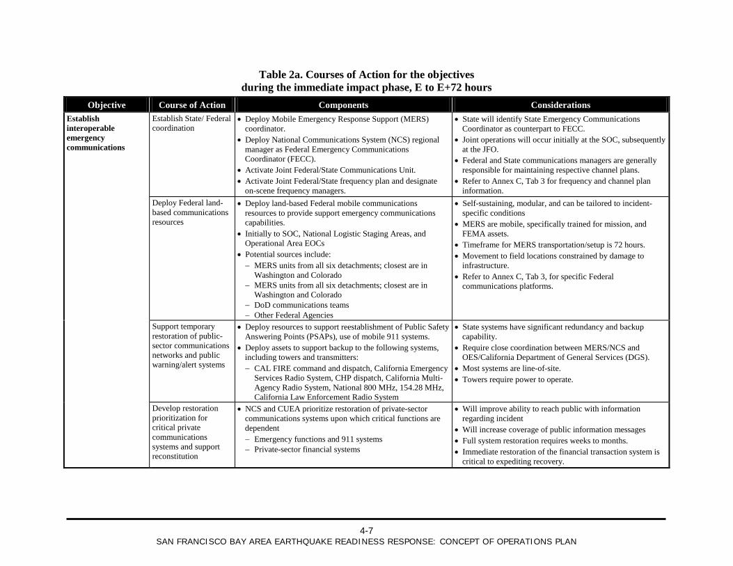
4.2.5 Courses of Action (COAs) For purposes of this document, a “Course of Action” is defined as the sequence of activities that an entity may take to accomplish a mission. Multiple COAs may be available to accomplish a mission.
COAs are presented for each objective in Tables 2a to 2c. COAs are in general State and Federal alternative actions that will be taken to support local response operations. Considerations are presented for each COA. Given incident-specific circumstances and the necessity for coordination with State and local governments to identify required resources, it is likely that multiple COAs will be implemented simultaneously to carry out the mission. Refer to the Tabs in Annex C for additional details regarding COAs. Each Tab includes a response timeline that outlines COAs on the context of the overall response of local, State, Federal, and (where applicable) private sector entities.
4.2.6 Execution Schedule The Execution Schedule (Table 3) lists specific Federal resources that are required to carry out COAs and the proposed timeframes for the actions.
4-7
SAN FRANCISCO BAY AREA EARTHQUAKE READINESS RESPONSE: CONCEPT OF OPERATIONS PLAN
Table 2a. Courses of Action for the objectives during the immediate impact phase, E to E+72 hours
Objective Course of Action Components Considerations Establish interoperable emergency communications
Establish State/ Federal coordination
• Deploy Mobile Emergency Response Support (MERS) coordinator.
• Deploy National Communications System (NCS) regional manager as Federal Emergency Communications Coordinator (FECC).
• Activate Joint Federal/State Communications Unit. • Activate Joint Federal/State frequency plan and designate
on-scene frequency managers.
• State will identify State Emergency Communications Coordinator as counterpart to FECC.
• Joint operations will occur initially at the SOC, subsequently at the JFO.
• Federal and State communications managers are generally responsible for maintaining respective channel plans.
• Refer to Annex C, Tab 3 for frequency and channel plan information.
Deploy Federal land-based communications resources
• Deploy land-based Federal mobile communications resources to provide support emergency communications capabilities.
• Initially to SOC, National Logistic Staging Areas, and Operational Area EOCs
• Potential sources include: − MERS units from all six detachments; closest are in
Washington and Colorado − MERS units from all six detachments; closest are in
Washington and Colorado − DoD communications teams − Other Federal Agencies
• Self-sustaining, modular, and can be tailored to incident-specific conditions
• MERS are mobile, specifically trained for mission, and FEMA assets.
• Timeframe for MERS transportation/setup is 72 hours. • Movement to field locations constrained by damage to
infrastructure. • Refer to Annex C, Tab 3, for specific Federal
communications platforms.
Support temporary restoration of public-sector communications networks and public warning/alert systems
• Deploy resources to support reestablishment of Public Safety Answering Points (PSAPs), use of mobile 911 systems.
• Deploy assets to support backup to the following systems, including towers and transmitters: − CAL FIRE command and dispatch, California Emergency
Services Radio System, CHP dispatch, California Multi-Agency Radio System, National 800 MHz, 154.28 MHz, California Law Enforcement Radio System
• State systems have significant redundancy and backup capability.
• Require close coordination between MERS/NCS and OES/California Department of General Services (DGS).
• Most systems are line-of-site. • Towers require power to operate.
Develop restoration prioritization for critical private communications systems and support reconstitution
• NCS and CUEA prioritize restoration of private-sector communications systems upon which critical functions are dependent − Emergency functions and 911 systems − Private-sector financial systems
• Will improve ability to reach public with information regarding incident
• Will increase coverage of public information messages • Full system restoration requires weeks to months. • Immediate restoration of the financial transaction system is
critical to expediting recovery.
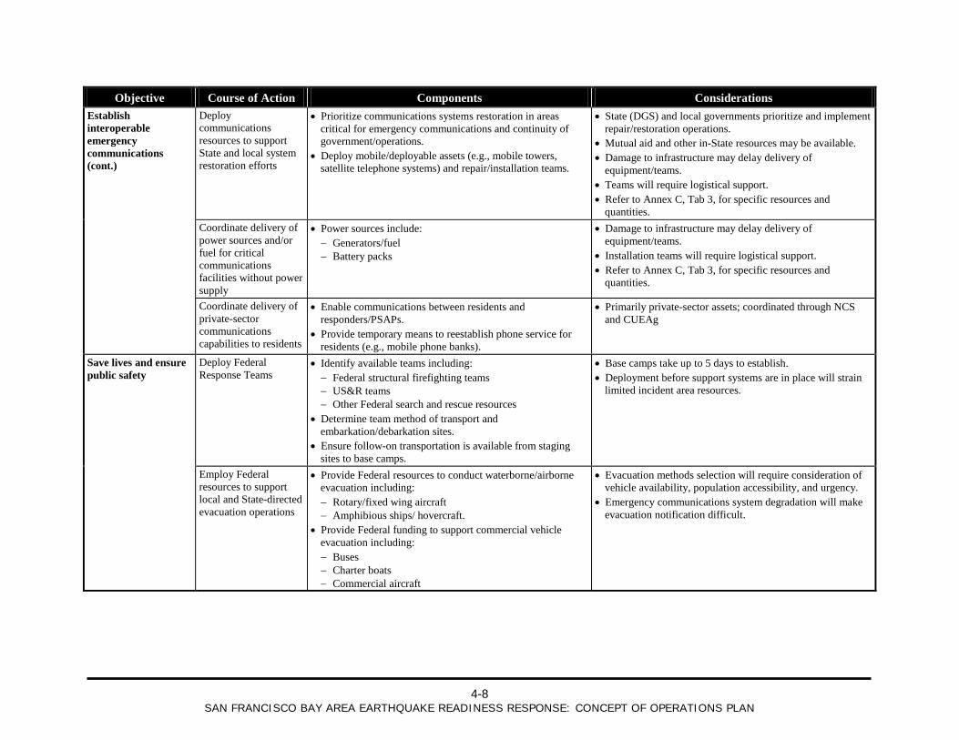
4-8
SAN FRANCISCO BAY AREA EARTHQUAKE READINESS RESPONSE: CONCEPT OF OPERATIONS PLAN
Objective Course of Action Components Considerations Establish interoperable emergency communications (cont.)
Deploy communications resources to support State and local system restoration efforts
• Prioritize communications systems restoration in areas critical for emergency communications and continuity of government/operations.
• Deploy mobile/deployable assets (e.g., mobile towers, satellite telephone systems) and repair/installation teams.
• State (DGS) and local governments prioritize and implement repair/restoration operations.
• Mutual aid and other in-State resources may be available. • Damage to infrastructure may delay delivery of
equipment/teams. • Teams will require logistical support. • Refer to Annex C, Tab 3, for specific resources and
quantities. Coordinate delivery of
power sources and/or fuel for critical communications facilities without power supply
• Power sources include: − Generators/fuel − Battery packs
• Damage to infrastructure may delay delivery of equipment/teams.
• Installation teams will require logistical support. • Refer to Annex C, Tab 3, for specific resources and
quantities.
Coordinate delivery of private-sector communications capabilities to residents
• Enable communications between residents and responders/PSAPs.
• Provide temporary means to reestablish phone service for residents (e.g., mobile phone banks).
• Primarily private-sector assets; coordinated through NCS and CUEAg
Save lives and ensure public safety
Deploy Federal Response Teams
• Identify available teams including: − Federal structural firefighting teams − US&R teams − Other Federal search and rescue resources
• Determine team method of transport and embarkation/debarkation sites.
• Ensure follow-on transportation is available from staging sites to base camps.
• Base camps take up to 5 days to establish. • Deployment before support systems are in place will strain
limited incident area resources.
Employ Federal resources to support local and State-directed evacuation operations
• Provide Federal resources to conduct waterborne/airborne evacuation including: − Rotary/fixed wing aircraft − Amphibious ships/ hovercraft.
• Provide Federal funding to support commercial vehicle evacuation including: − Buses − Charter boats − Commercial aircraft
• Evacuation methods selection will require consideration of vehicle availability, population accessibility, and urgency.
• Emergency communications system degradation will make evacuation notification difficult.
4-9
SAN FRANCISCO BAY AREA EARTHQUAKE READINESS RESPONSE: CONCEPT OF OPERATIONS PLAN
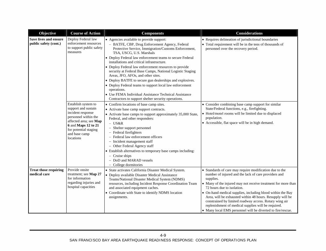
Objective Course of Action Components Considerations Save lives and ensure public safety (cont.)
Deploy Federal law enforcement resources to support public safety measures
• Agencies available to provide support: − BATFE, CBP, Drug Enforcement Agency, Federal
Protective Service, Immigration/Customs Enforcement, TSA, USCG, U.S. Marshals
• Deploy Federal law enforcement teams to secure Federal installations and critical infrastructure.
• Deploy Federal law enforcement resources to provide security at Federal Base Camps, National Logistic Staging Areas, JFO, AFOs, and other sites.
• Deploy BATFE to secure gun dealerships and explosives. • Deploy Federal teams to support local law enforcement
operations. • Use FEMA Individual Assistance Technical Assistance
Contractors to support shelter security operations.
• Requires delineation of jurisdictional boundaries • Total requirement will be in the tens of thousands of
personnel over the recovery period.
Establish system to support and sustain incident response personnel within the affected area; see Map 6 and Maps 12 to 21 for potential staging and base camp locations
• Confirm locations of base camp sites. • Activate base camp support contracts. • Activate base camps to support approximately 35,000 State,
Federal, and other responders: − US&R − Shelter support personnel − Federal firefighters − Federal law enforcement officers − Incident management staff − Other Federal Agency staff
• Establish alternatives to temporary base camps including: − Cruise ships − DoD and MARAD vessels − College dormitories
• Consider combining base camp support for similar State/Federal functions, e.g., firefighting.
• Hotel/motel rooms will be limited due to displaced population.
• Accessible, flat space will be in high demand.
Treat those requiring medical care
Provide onsite treatment; see Map 27 for information regarding injuries and hospital capacities
• State activates California Disaster Medical System. • Deploy available Disaster Medical Assistance
Teams/National Disaster Medical System (NDMS) resources, including Incident Response Coordination Team and associated equipment caches.
• Coordinate with State to identify NDMS location assignments.
• Standards of care may require modification due to the number of injured and the lack of care providers and supplies.
• Many of the injured may not receive treatment for more than 72 hours due to isolation.
• On-hand medical supplies, including blood within the Bay Area, will be exhausted within 48 hours. Resupply will be constrained by limited roadway access. Rotary wing air replenishment of medical supplies will be required.
• Many local EMS personnel will be diverted to fire/rescue.
4-10
SAN FRANCISCO BAY AREA EARTHQUAKE READINESS RESPONSE: CONCEPT OF OPERATIONS PLAN
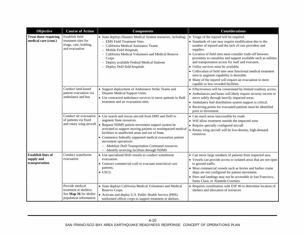
Objective Course of Action Components Considerations Treat those requiring medical care (cont.)
Establish field treatment sites for triage, care, holding, and evacuation
• State deploys Disaster Medical System resources, including: − EMS Field Treatment Sites − California Medical Assistance Teams − Mobile Field Hospitals − California Medical Volunteers and Medical Reserve
Corps − Deploy available Federal Medical Stations − Deploy DoD field hospitals
• Triage of the injured will be required. • Standards of care may require modification due to the
number of injured and the lack of care providers and supplies.
• Location of field sites must consider trade-off between proximity to casualties and support available such as utilities and transportation access for staff and evacuees.
• Utility services must be available. • Collocation of field sites near functional medical treatment
sites to augment capability is desirable. • Many of the injured will require air evacuation to more
capable or less crowded facilities. Conduct land-based
patient evacuation via ambulance and bus
• Support deployment of Ambulance Strike Teams and Disaster Medical Support Units.
• Use contracted ambulance services to move patients to field treatment and air evacuation sites.
• Effectiveness will be constrained by limited roadway access. • Ambulances and buses will likely require security escorts to
move safely through heavily impacted areas. • Ambulance fuel distribution system support is critical. • Receiving points for evacuated patients must be identified
prior to movement. Conduct air evacuation
of patients via fixed and rotary wing aircraft
• Use search and rescue aircraft from DHS and DoD to augment State resources.
• Request NDMS patient movement support system be activated to support moving patients to nonimpacted medical facilities in unaffected areas and out of State.
• Commence federally supported medical evacuation patient movement operations: − -Mobilize DoD Transportation Command resources − -Identify receiving facilities through NDMS
• Can reach areas inaccessible by roads • Will allow treatment outside the impacted zone • Require specially configured aircraft • Rotary wing aircraft will be low-density, high-demand
resources.
Establish lines of supply and transportation
Conduct waterborne evacuation
• Use specialized DoD vessels to conduct waterborne evacuation.
• Contract commercial craft to evacuate noncritical care patients.
• USCG
• Can move large numbers of patients from impacted area • Vessels can provide access to isolated areas that are not open
to ground traffic. • Most commercial vessels such as ferries and harbor cruise
ships are not configured for patient movement. • Piers and landings may not be accessible in San Francisco,
Santa Clara, or Alameda Counties. Provide medical
treatment at shelters; See Map 26 for shelter population information
• State deploys California Medical Volunteers and Medical Reserve Corps.
• Activate and deploy U.S. Public Health Service (PHS) uniformed officer corps to support treatment at shelters.
• Requires coordination with ESF #6 to determine location of shelters and allocation of resources
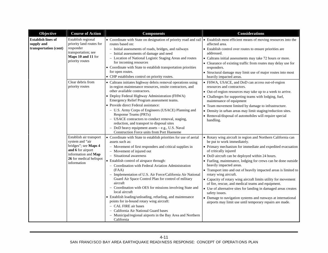
4-11
SAN FRANCISCO BAY AREA EARTHQUAKE READINESS RESPONSE: CONCEPT OF OPERATIONS PLAN
Objective Course of Action Components Considerations Establish lines of supply and transportation (cont)
Establish regional priority land routes for responder transportation; see Maps 10 and 11 for priority routes
• Coordinate with State on designation of priority road and rail routes based on: − Initial assessments of roads, bridges, and railways − Initial assessments of damage and need − Location of National Logistic Staging Areas and routes
for incoming resources • Coordinate with State to establish transportation priorities
for open routes. • CHP establishes control on priority routes.
• Establish most efficient means of moving resources into the affected area.
• Establish control over routes to ensure priorities are addressed.
• Caltrans initial assessments may take 72 hours or more. • Clearance of existing traffic from routes may delay use for
responders. • Structural damage may limit use of major routes into most
heavily impacted areas. Clear debris from
priority routes • Caltrans initiates highway debris removal operations using
in-region maintenance resources, onsite contractors, and other available contractors.
• Deploy Federal Highway Administration (FHWA) Emergency Relief Program assessment teams.
• Provide direct Federal assistance: − U.S. Army Corps of Engineers (USACE) Planning and
Response Teams (PRTs) − USACE contractors to conduct removal, staging,
reduction, and transport to disposal sites − DoD heavy equipment assets – e.g., U.S. Naval
Construction Force units from Port Hueneme
• FHWA, USACE, and DoD can access out-of-region resources and contractors.
• Out-of-region resources may take up to a week to arrive. • Challenges for supporting teams with lodging, fuel,
maintenance of equipment • Team movement limited by damage to infrastructure. • Density in urban areas may limit staging/reduction sites. • Removal/disposal of automobiles will require special
handling.
Establish air transport system and “air bridges”; see Maps 4 and 6 for airport information and Map 26 for medical helispot information
• Coordinate with State to establish priorities for use of aerial assets such as: − Movement of first responders and critical supplies in − Movement of injured out − Situational awareness
• Establish control of airspace through: − Coordination with Federal Aviation Administration
(FAA) − Implementation of U.S. Air Force/California Air National
Guard Air Space Control Plan for control of military aircraft
− Coordination with OES for missions involving State and local aircraft
• Establish loading/unloading, refueling, and maintenance points for in-bound rotary wing aircraft: − CAL FIRE air bases − California Air National Guard bases − Municipal/regional airports in the Bay Area and Northern
California
• Rotary wing aircraft in region and Northern California can be put to work immediately.
• Primary mechanism for immediate and expedited evacuation of critically injured
• DoD aircraft can be deployed within 24 hours. • Fueling, maintenance, lodging for crews can be done outside
heavily impacted areas. • Transport into and out of heavily impacted areas is limited to
rotary wing aircraft. • Capacity of rotary wing aircraft limits utility for movement
of fire, rescue, and medical teams and equipment. • Use of alternative sites for landing in damaged areas creates
safety issues. • Damage to navigation systems and runways at international
airports may limit use until temporary repairs are made.
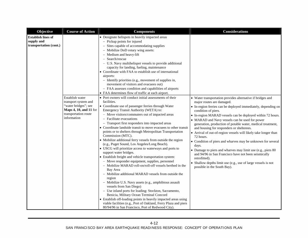
4-12
SAN FRANCISCO BAY AREA EARTHQUAKE READINESS RESPONSE: CONCEPT OF OPERATIONS PLAN
Objective Course of Action Components Considerations Establish lines of supply and transportation (cont.)
• Designate helispots in heavily impacted areas − Pickup points for injured − Sites capable of accommodating supplies − Mobilize DoD rotary wing assets: − Medium and heavy-lift − Search/rescue − U.S. Navy multihelispot vessels to provide additional
capacity for landing, fueling, maintenance • Coordinate with FAA to establish use of international
airports: − Identify priorities (e.g., movement of supplies in,
movement of visitors and evacuees out) − FAA assesses condition and capabilities of airports
• FAA determines flow of traffic at each airport.
Establish water transport system and “water bridges”; see Maps 4, 10, and 11 for transportation route information
• Port owners will conduct initial assessments of their facilities.
• Coordinate use of passenger ferries through Water Emergency Transit Authority (WETA) to: − Move visitors/commuters out of impacted areas − Facilitate evacuations − Transport first responders into impacted areas
• Coordinate landside transit to move evacuees to other transit points or to shelters through Metropolitan Transportation Commission (MTC).
• Mobilize additional ferry vessels from outside the region (e.g., Puget Sound, Los Angeles/Long Beach).
• USCG will prioritize access to waterways and ports to support water bridges.
• Establish freight and vehicle transportation system: − Move responder equipment, supplies, personnel − Mobilize MARAD roll-on/roll-off vessels berthed in the
Bay Area − Mobilize additional MARAD vessels from outside the
region − Mobilize U.S. Navy assets (e.g., amphibious assault
vessels from San Diego) − Use inland ports for loading: Stockton, Sacramento,
Benicia, Military Ocean Terminal Concord • Establish off-loading points in heavily impacted areas using
viable facilities (e.g., Port of Oakland, Ferry Plaza and piers 80/94/96 in San Francisco, Port of Redwood City).
• Water transportation provides alternative if bridges and major routes are damaged.
• In-region ferries can be deployed immediately, depending on condition of piers.
• In-region MARAD vessels can be deployed within 72 hours. • MARAD and Navy vessels can be used for power
generation, production of potable water, medical treatment, and housing for responders or shelterees.
• Arrival of out-of-region vessels will likely take longer than 72 hours.
• Condition of piers and wharves may be unknown for several days.
• Damage to piers and wharves may limit use (e.g., piers 80 and 94/96 in San Francisco have not been seismically retrofitted).
• Shallow depths limit use (e.g., use of large vessels is not possible in the South Bay).
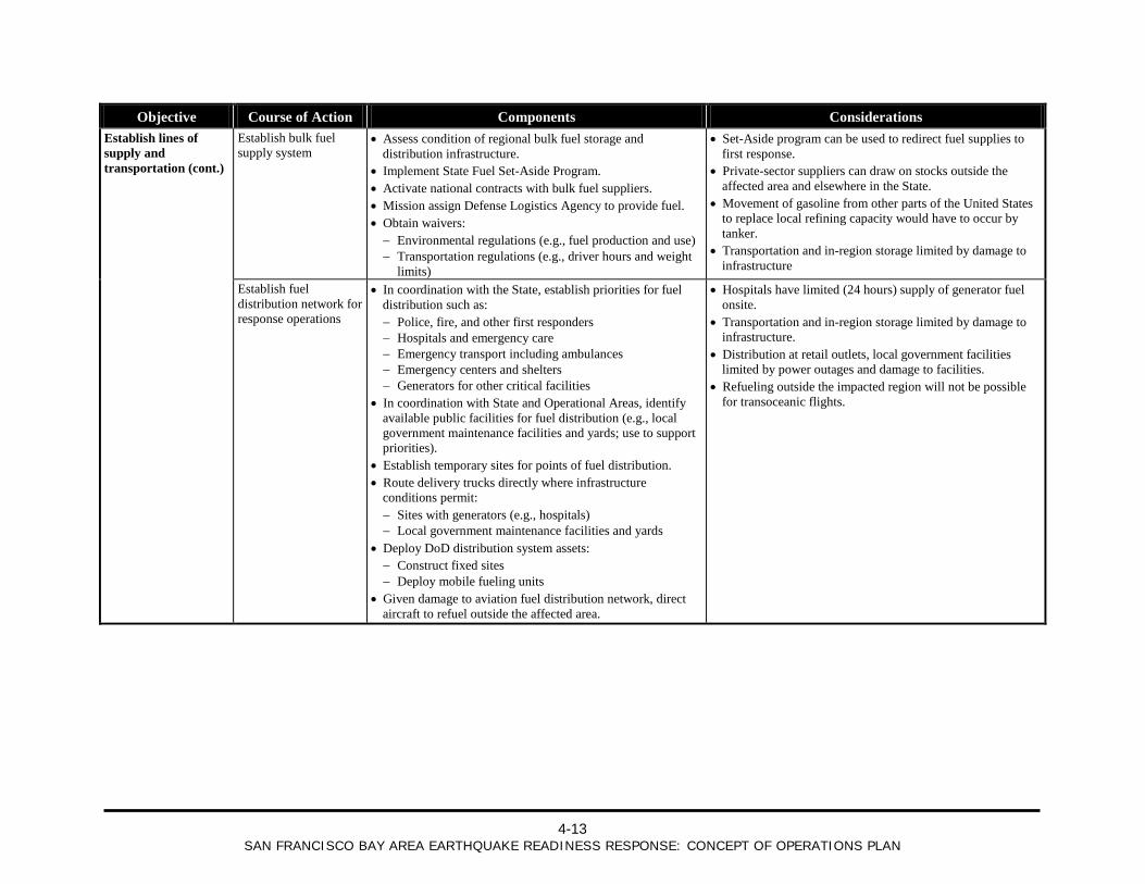
4-13
SAN FRANCISCO BAY AREA EARTHQUAKE READINESS RESPONSE: CONCEPT OF OPERATIONS PLAN
Objective Course of Action Components Considerations Establish lines of supply and transportation (cont.)
Establish bulk fuel supply system
• Assess condition of regional bulk fuel storage and distribution infrastructure.
• Implement State Fuel Set-Aside Program. • Activate national contracts with bulk fuel suppliers. • Mission assign Defense Logistics Agency to provide fuel. • Obtain waivers: − Environmental regulations (e.g., fuel production and use) − Transportation regulations (e.g., driver hours and weight
limits)
• Set-Aside program can be used to redirect fuel supplies to first response.
• Private-sector suppliers can draw on stocks outside the affected area and elsewhere in the State.
• Movement of gasoline from other parts of the United States to replace local refining capacity would have to occur by tanker.
• Transportation and in-region storage limited by damage to infrastructure
Establish fuel distribution network for response operations
• In coordination with the State, establish priorities for fuel distribution such as: − Police, fire, and other first responders − Hospitals and emergency care − Emergency transport including ambulances − Emergency centers and shelters − Generators for other critical facilities
• In coordination with State and Operational Areas, identify available public facilities for fuel distribution (e.g., local government maintenance facilities and yards; use to support priorities).
• Establish temporary sites for points of fuel distribution. • Route delivery trucks directly where infrastructure
conditions permit: − Sites with generators (e.g., hospitals) − Local government maintenance facilities and yards
• Deploy DoD distribution system assets: − Construct fixed sites − Deploy mobile fueling units
• Given damage to aviation fuel distribution network, direct aircraft to refuel outside the affected area.
• Hospitals have limited (24 hours) supply of generator fuel onsite.
• Transportation and in-region storage limited by damage to infrastructure.
• Distribution at retail outlets, local government facilities limited by power outages and damage to facilities.
• Refueling outside the impacted region will not be possible for transoceanic flights.
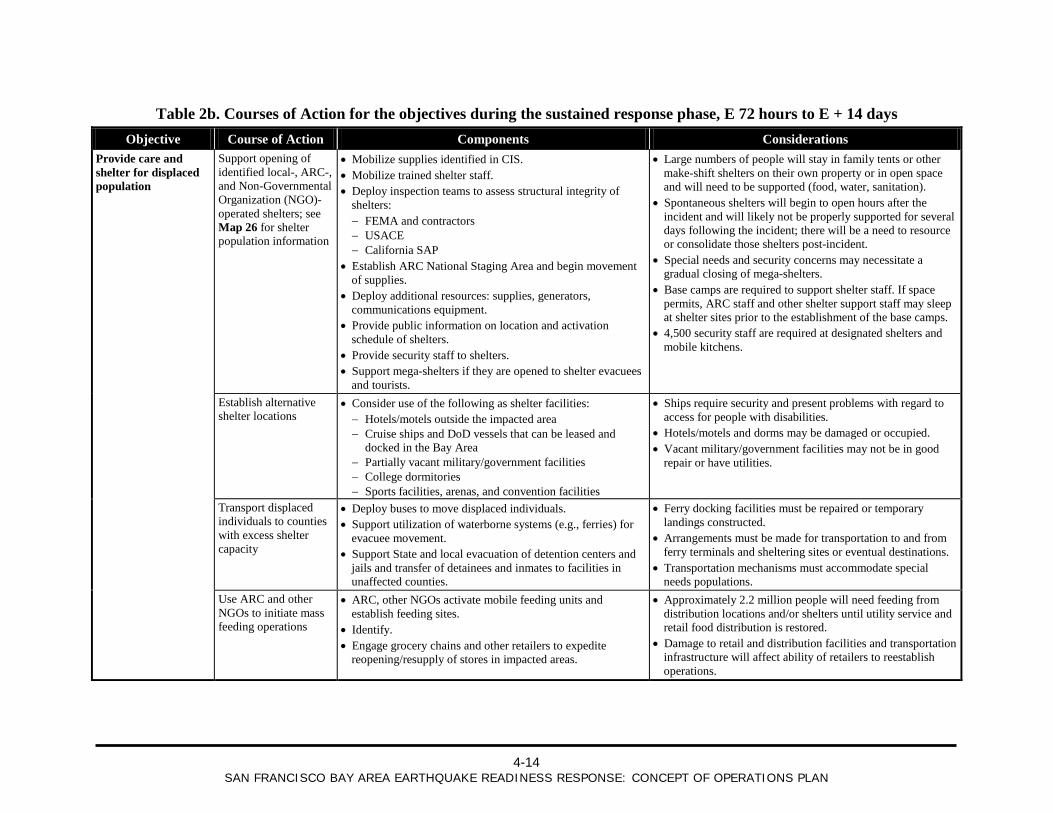
4-14
SAN FRANCISCO BAY AREA EARTHQUAKE READINESS RESPONSE: CONCEPT OF OPERATIONS PLAN
Table 2b. Courses of Action for the objectives during the sustained response phase, E 72 hours to E + 14 days Objective Course of Action Components Considerations
Provide care and shelter for displaced population
Support opening of identified local-, ARC-, and Non-Governmental Organization (NGO)-operated shelters; see Map 26 for shelter population information
• Mobilize supplies identified in CIS. • Mobilize trained shelter staff. • Deploy inspection teams to assess structural integrity of
shelters: − FEMA and contractors − USACE − California SAP
• Establish ARC National Staging Area and begin movement of supplies.
• Deploy additional resources: supplies, generators, communications equipment.
• Provide public information on location and activation schedule of shelters.
• Provide security staff to shelters. • Support mega-shelters if they are opened to shelter evacuees
and tourists.
• Large numbers of people will stay in family tents or other make-shift shelters on their own property or in open space and will need to be supported (food, water, sanitation).
• Spontaneous shelters will begin to open hours after the incident and will likely not be properly supported for several days following the incident; there will be a need to resource or consolidate those shelters post-incident.
• Special needs and security concerns may necessitate a gradual closing of mega-shelters.
• Base camps are required to support shelter staff. If space permits, ARC staff and other shelter support staff may sleep at shelter sites prior to the establishment of the base camps.
• 4,500 security staff are required at designated shelters and mobile kitchens.
Establish alternative shelter locations
• Consider use of the following as shelter facilities: − Hotels/motels outside the impacted area − Cruise ships and DoD vessels that can be leased and
docked in the Bay Area − Partially vacant military/government facilities − College dormitories − Sports facilities, arenas, and convention facilities
• Ships require security and present problems with regard to access for people with disabilities.
• Hotels/motels and dorms may be damaged or occupied. • Vacant military/government facilities may not be in good
repair or have utilities.
Transport displaced individuals to counties with excess shelter capacity
• Deploy buses to move displaced individuals. • Support utilization of waterborne systems (e.g., ferries) for
evacuee movement. • Support State and local evacuation of detention centers and
jails and transfer of detainees and inmates to facilities in unaffected counties.
• Ferry docking facilities must be repaired or temporary landings constructed.
• Arrangements must be made for transportation to and from ferry terminals and sheltering sites or eventual destinations.
• Transportation mechanisms must accommodate special needs populations.
Use ARC and other NGOs to initiate mass feeding operations
• ARC, other NGOs activate mobile feeding units and establish feeding sites.
• Identify. • Engage grocery chains and other retailers to expedite
reopening/resupply of stores in impacted areas.
• Approximately 2.2 million people will need feeding from distribution locations and/or shelters until utility service and retail food distribution is restored.
• Damage to retail and distribution facilities and transportation infrastructure will affect ability of retailers to reestablish operations.
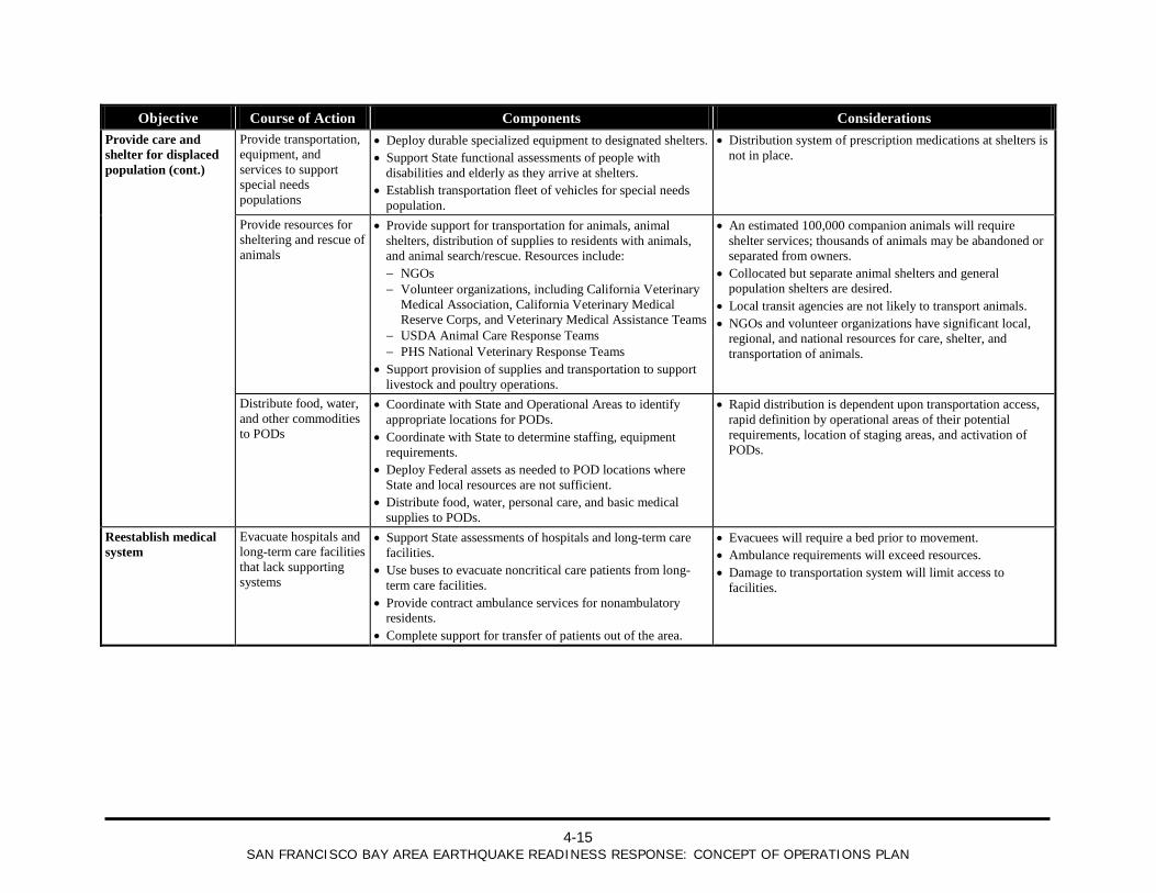
4-15
SAN FRANCISCO BAY AREA EARTHQUAKE READINESS RESPONSE: CONCEPT OF OPERATIONS PLAN
Objective Course of Action Components Considerations Provide care and shelter for displaced population (cont.)
Provide transportation, equipment, and services to support special needs populations
• Deploy durable specialized equipment to designated shelters. • Support State functional assessments of people with
disabilities and elderly as they arrive at shelters. • Establish transportation fleet of vehicles for special needs
population.
• Distribution system of prescription medications at shelters is not in place.
Provide resources for sheltering and rescue of animals
• Provide support for transportation for animals, animal shelters, distribution of supplies to residents with animals, and animal search/rescue. Resources include: − NGOs − Volunteer organizations, including California Veterinary
Medical Association, California Veterinary Medical Reserve Corps, and Veterinary Medical Assistance Teams
− USDA Animal Care Response Teams − PHS National Veterinary Response Teams
• Support provision of supplies and transportation to support livestock and poultry operations.
• An estimated 100,000 companion animals will require shelter services; thousands of animals may be abandoned or separated from owners.
• Collocated but separate animal shelters and general population shelters are desired.
• Local transit agencies are not likely to transport animals. • NGOs and volunteer organizations have significant local,
regional, and national resources for care, shelter, and transportation of animals.
Distribute food, water, and other commodities to PODs
• Coordinate with State and Operational Areas to identify appropriate locations for PODs.
• Coordinate with State to determine staffing, equipment requirements.
• Deploy Federal assets as needed to POD locations where State and local resources are not sufficient.
• Distribute food, water, personal care, and basic medical supplies to PODs.
• Rapid distribution is dependent upon transportation access, rapid definition by operational areas of their potential requirements, location of staging areas, and activation of PODs.
Reestablish medical system
Evacuate hospitals and long-term care facilities that lack supporting systems
• Support State assessments of hospitals and long-term care facilities.
• Use buses to evacuate noncritical care patients from long-term care facilities.
• Provide contract ambulance services for nonambulatory residents.
• Complete support for transfer of patients out of the area.
• Evacuees will require a bed prior to movement. • Ambulance requirements will exceed resources. • Damage to transportation system will limit access to
facilities.
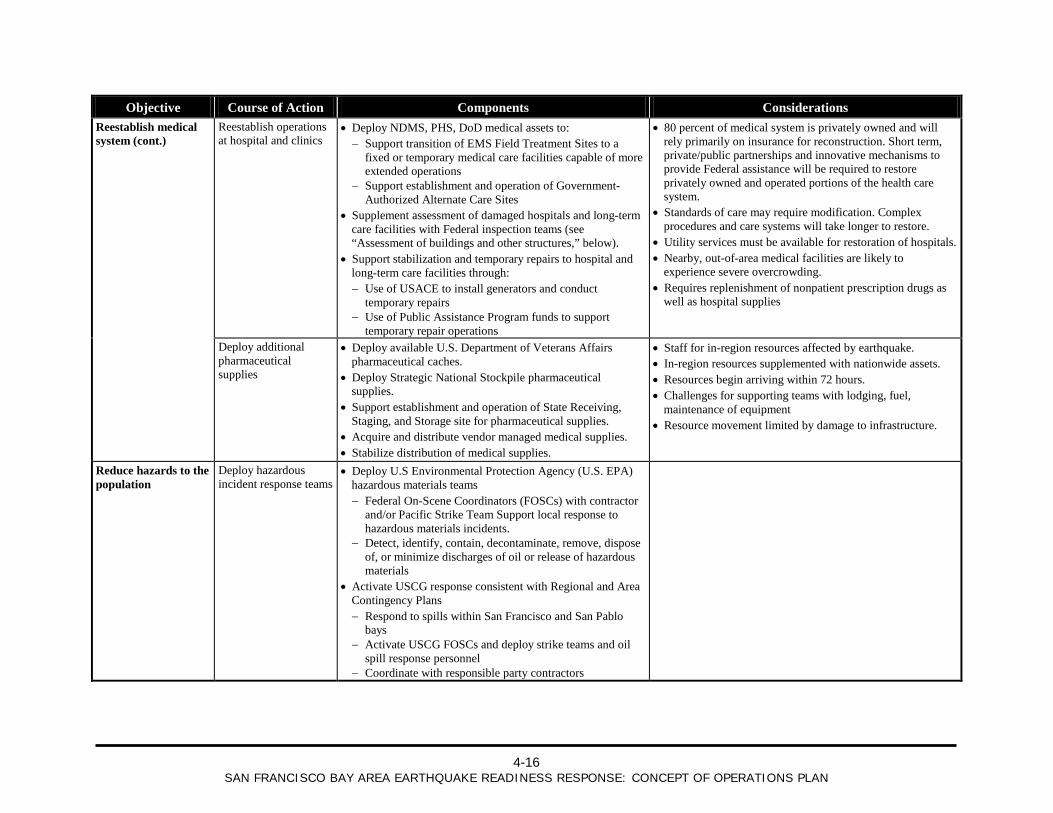
4-16
SAN FRANCISCO BAY AREA EARTHQUAKE READINESS RESPONSE: CONCEPT OF OPERATIONS PLAN
Objective Course of Action Components Considerations Reestablish medical system (cont.)
Reestablish operations at hospital and clinics
• Deploy NDMS, PHS, DoD medical assets to: − Support transition of EMS Field Treatment Sites to a
fixed or temporary medical care facilities capable of more extended operations
− Support establishment and operation of Government-Authorized Alternate Care Sites
• Supplement assessment of damaged hospitals and long-term care facilities with Federal inspection teams (see “Assessment of buildings and other structures,” below).
• Support stabilization and temporary repairs to hospital and long-term care facilities through: − Use of USACE to install generators and conduct
temporary repairs − Use of Public Assistance Program funds to support
temporary repair operations
• 80 percent of medical system is privately owned and will rely primarily on insurance for reconstruction. Short term, private/public partnerships and innovative mechanisms to provide Federal assistance will be required to restore privately owned and operated portions of the health care system.
• Standards of care may require modification. Complex procedures and care systems will take longer to restore.
• Utility services must be available for restoration of hospitals. • Nearby, out-of-area medical facilities are likely to
experience severe overcrowding. • Requires replenishment of nonpatient prescription drugs as
well as hospital supplies
Deploy additional pharmaceutical supplies
• Deploy available U.S. Department of Veterans Affairs pharmaceutical caches.
• Deploy Strategic National Stockpile pharmaceutical supplies.
• Support establishment and operation of State Receiving, Staging, and Storage site for pharmaceutical supplies.
• Acquire and distribute vendor managed medical supplies. • Stabilize distribution of medical supplies.
• Staff for in-region resources affected by earthquake. • In-region resources supplemented with nationwide assets. • Resources begin arriving within 72 hours. • Challenges for supporting teams with lodging, fuel,
maintenance of equipment • Resource movement limited by damage to infrastructure.
Reduce hazards to the population
Deploy hazardous incident response teams
• Deploy U.S Environmental Protection Agency (U.S. EPA) hazardous materials teams − Federal On-Scene Coordinators (FOSCs) with contractor
and/or Pacific Strike Team Support local response to hazardous materials incidents.
− Detect, identify, contain, decontaminate, remove, dispose of, or minimize discharges of oil or release of hazardous materials
• Activate USCG response consistent with Regional and Area Contingency Plans − Respond to spills within San Francisco and San Pablo
bays − Activate USCG FOSCs and deploy strike teams and oil
spill response personnel − Coordinate with responsible party contractors
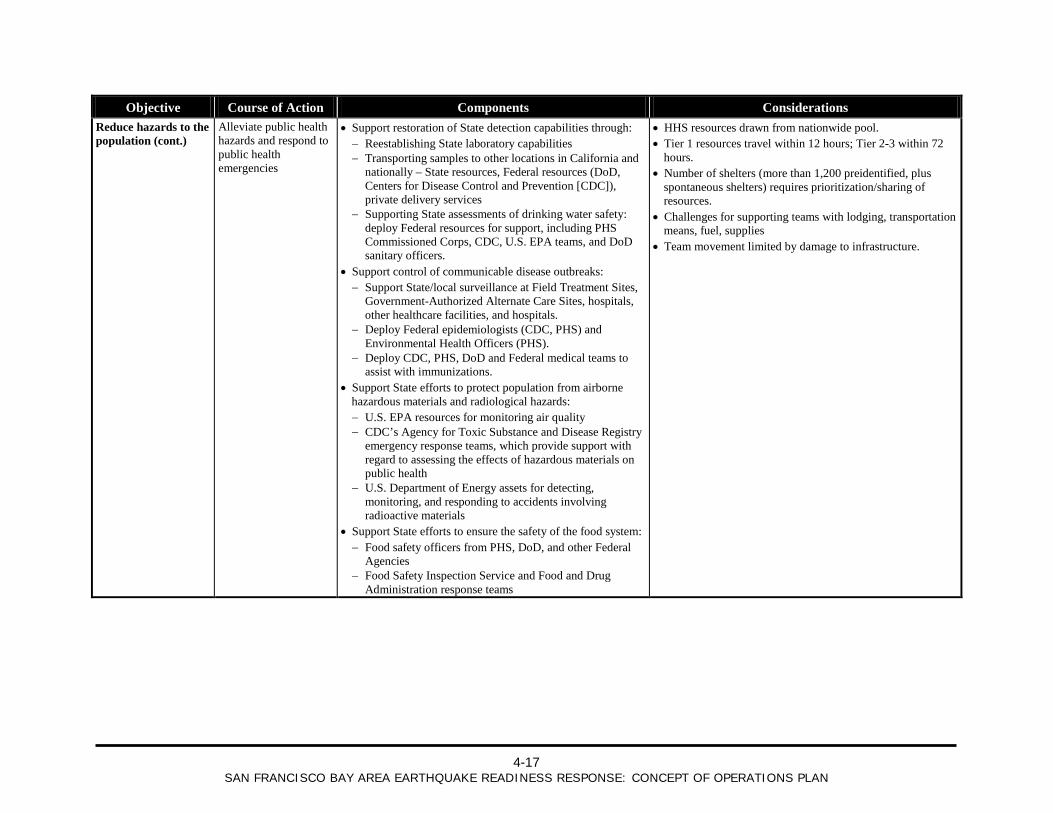
4-17
SAN FRANCISCO BAY AREA EARTHQUAKE READINESS RESPONSE: CONCEPT OF OPERATIONS PLAN
Objective Course of Action Components Considerations Reduce hazards to the population (cont.)
Alleviate public health hazards and respond to public health emergencies
• Support restoration of State detection capabilities through: − Reestablishing State laboratory capabilities − Transporting samples to other locations in California and
nationally – State resources, Federal resources (DoD, Centers for Disease Control and Prevention [CDC]), private delivery services
− Supporting State assessments of drinking water safety: deploy Federal resources for support, including PHS Commissioned Corps, CDC, U.S. EPA teams, and DoD sanitary officers.
• Support control of communicable disease outbreaks: − Support State/local surveillance at Field Treatment Sites,
Government-Authorized Alternate Care Sites, hospitals, other healthcare facilities, and hospitals.
− Deploy Federal epidemiologists (CDC, PHS) and Environmental Health Officers (PHS).
− Deploy CDC, PHS, DoD and Federal medical teams to assist with immunizations.
• Support State efforts to protect population from airborne hazardous materials and radiological hazards: − U.S. EPA resources for monitoring air quality − CDC’s Agency for Toxic Substance and Disease Registry
emergency response teams, which provide support with regard to assessing the effects of hazardous materials on public health
− U.S. Department of Energy assets for detecting, monitoring, and responding to accidents involving radioactive materials
• Support State efforts to ensure the safety of the food system: − Food safety officers from PHS, DoD, and other Federal
Agencies − Food Safety Inspection Service and Food and Drug
Administration response teams
• HHS resources drawn from nationwide pool. • Tier 1 resources travel within 12 hours; Tier 2-3 within 72
hours. • Number of shelters (more than 1,200 preidentified, plus
spontaneous shelters) requires prioritization/sharing of resources.
• Challenges for supporting teams with lodging, transportation means, fuel, supplies
• Team movement limited by damage to infrastructure.
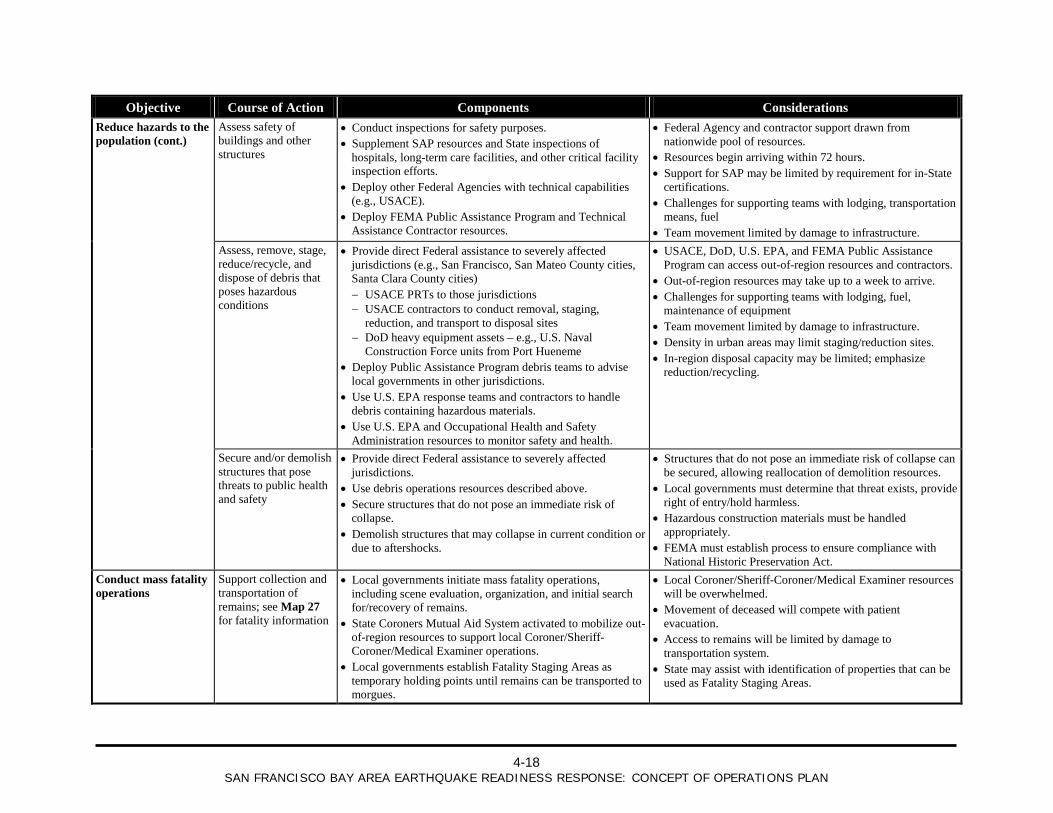
4-18
SAN FRANCISCO BAY AREA EARTHQUAKE READINESS RESPONSE: CONCEPT OF OPERATIONS PLAN
Objective Course of Action Components Considerations Reduce hazards to the population (cont.)
Assess safety of buildings and other structures
• Conduct inspections for safety purposes. • Supplement SAP resources and State inspections of
hospitals, long-term care facilities, and other critical facility inspection efforts.
• Deploy other Federal Agencies with technical capabilities (e.g., USACE).
• Deploy FEMA Public Assistance Program and Technical Assistance Contractor resources.
• Federal Agency and contractor support drawn from nationwide pool of resources.
• Resources begin arriving within 72 hours. • Support for SAP may be limited by requirement for in-State
certifications. • Challenges for supporting teams with lodging, transportation
means, fuel • Team movement limited by damage to infrastructure.
Assess, remove, stage, reduce/recycle, and dispose of debris that poses hazardous conditions
• Provide direct Federal assistance to severely affected jurisdictions (e.g., San Francisco, San Mateo County cities, Santa Clara County cities) − USACE PRTs to those jurisdictions − USACE contractors to conduct removal, staging,
reduction, and transport to disposal sites − DoD heavy equipment assets – e.g., U.S. Naval
Construction Force units from Port Hueneme • Deploy Public Assistance Program debris teams to advise
local governments in other jurisdictions. • Use U.S. EPA response teams and contractors to handle
debris containing hazardous materials. • Use U.S. EPA and Occupational Health and Safety
Administration resources to monitor safety and health.
• USACE, DoD, U.S. EPA, and FEMA Public Assistance Program can access out-of-region resources and contractors.
• Out-of-region resources may take up to a week to arrive. • Challenges for supporting teams with lodging, fuel,
maintenance of equipment • Team movement limited by damage to infrastructure. • Density in urban areas may limit staging/reduction sites. • In-region disposal capacity may be limited; emphasize
reduction/recycling.
Secure and/or demolish structures that pose threats to public health and safety
• Provide direct Federal assistance to severely affected jurisdictions.
• Use debris operations resources described above. • Secure structures that do not pose an immediate risk of
collapse. • Demolish structures that may collapse in current condition or
due to aftershocks.
• Structures that do not pose an immediate risk of collapse can be secured, allowing reallocation of demolition resources.
• Local governments must determine that threat exists, provide right of entry/hold harmless.
• Hazardous construction materials must be handled appropriately.
• FEMA must establish process to ensure compliance with National Historic Preservation Act.
Conduct mass fatality operations
Support collection and transportation of remains; see Map 27 for fatality information
• Local governments initiate mass fatality operations, including scene evaluation, organization, and initial search for/recovery of remains.
• State Coroners Mutual Aid System activated to mobilize out-of-region resources to support local Coroner/Sheriff-Coroner/Medical Examiner operations.
• Local governments establish Fatality Staging Areas as temporary holding points until remains can be transported to morgues.
• Local Coroner/Sheriff-Coroner/Medical Examiner resources will be overwhelmed.
• Movement of deceased will compete with patient evacuation.
• Access to remains will be limited by damage to transportation system.
• State may assist with identification of properties that can be used as Fatality Staging Areas.
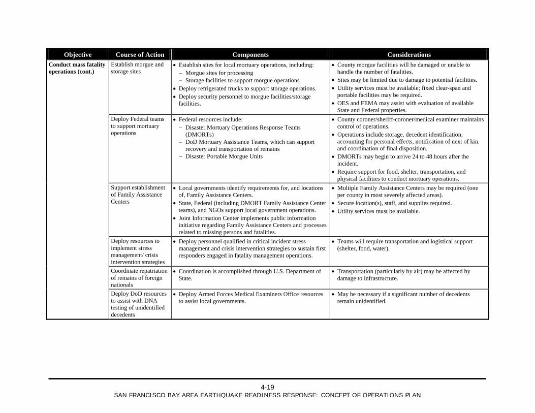
4-19
SAN FRANCISCO BAY AREA EARTHQUAKE READINESS RESPONSE: CONCEPT OF OPERATIONS PLAN
Objective Course of Action Components Considerations Conduct mass fatality operations (cont.)
Establish morgue and storage sites
• Establish sites for local mortuary operations, including: − Morgue sites for processing − Storage facilities to support morgue operations
• Deploy refrigerated trucks to support storage operations. • Deploy security personnel to morgue facilities/storage
facilities.
• County morgue facilities will be damaged or unable to handle the number of fatalities.
• Sites may be limited due to damage to potential facilities. • Utility services must be available; fixed clear-span and
portable facilities may be required. • OES and FEMA may assist with evaluation of available
State and Federal properties. Deploy Federal teams
to support mortuary operations
• Federal resources include: − Disaster Mortuary Operations Response Teams
(DMORTs) − DoD Mortuary Assistance Teams, which can support
recovery and transportation of remains − Disaster Portable Morgue Units
• County coroner/sheriff-coroner/medical examiner maintains control of operations.
• Operations include storage, decedent identification, accounting for personal effects, notification of next of kin, and coordination of final disposition.
• DMORTs may begin to arrive 24 to 48 hours after the incident.
• Require support for food, shelter, transportation, and physical facilities to conduct mortuary operations.
Support establishment of Family Assistance Centers
• Local governments identify requirements for, and locations of, Family Assistance Centers.
• State, Federal (including DMORT Family Assistance Center teams), and NGOs support local government operations.
• Joint Information Center implements public information initiative regarding Family Assistance Centers and processes related to missing persons and fatalities.
• Multiple Family Assistance Centers may be required (one per county in most severely affected areas).
• Secure location(s), staff, and supplies required. • Utility services must be available.
Deploy resources to implement stress management/ crisis intervention strategies
• Deploy personnel qualified in critical incident stress management and crisis intervention strategies to sustain first responders engaged in fatality management operations.
• Teams will require transportation and logistical support (shelter, food, water).
Coordinate repatriation of remains of foreign nationals
• Coordination is accomplished through U.S. Department of State.
• Transportation (particularly by air) may be affected by damage to infrastructure.
Deploy DoD resources to assist with DNA testing of unidentified decedents
• Deploy Armed Forces Medical Examiners Office resources to assist local governments.
• May be necessary if a significant number of decedents remain unidentified.
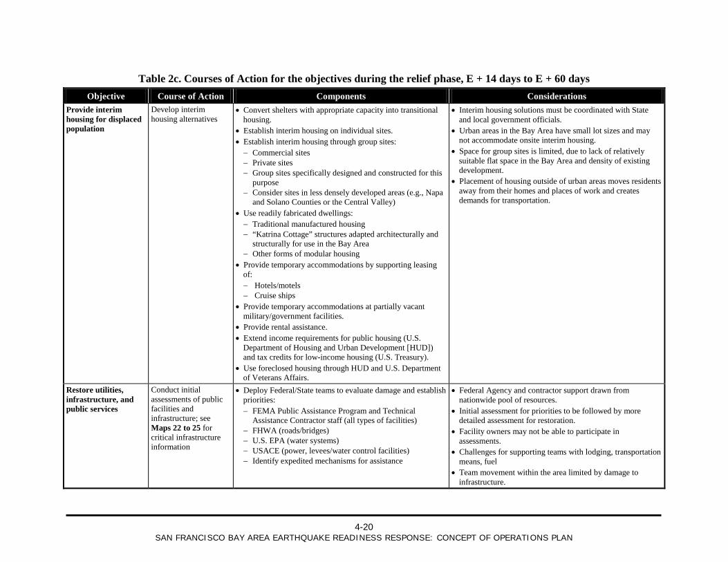
4-20
SAN FRANCISCO BAY AREA EARTHQUAKE READINESS RESPONSE: CONCEPT OF OPERATIONS PLAN
Table 2c. Courses of Action for the objectives during the relief phase, E + 14 days to E + 60 days Objective Course of Action Components Considerations
Provide interim housing for displaced population
Develop interim housing alternatives
• Convert shelters with appropriate capacity into transitional housing.
• Establish interim housing on individual sites. • Establish interim housing through group sites: − Commercial sites − Private sites − Group sites specifically designed and constructed for this
purpose − Consider sites in less densely developed areas (e.g., Napa
and Solano Counties or the Central Valley) • Use readily fabricated dwellings: − Traditional manufactured housing − “Katrina Cottage” structures adapted architecturally and
structurally for use in the Bay Area − Other forms of modular housing
• Provide temporary accommodations by supporting leasing of: − Hotels/motels − Cruise ships
• Provide temporary accommodations at partially vacant military/government facilities.
• Provide rental assistance. • Extend income requirements for public housing (U.S.
Department of Housing and Urban Development [HUD]) and tax credits for low-income housing (U.S. Treasury).
• Use foreclosed housing through HUD and U.S. Department of Veterans Affairs.
• Interim housing solutions must be coordinated with State and local government officials.
• Urban areas in the Bay Area have small lot sizes and may not accommodate onsite interim housing.
• Space for group sites is limited, due to lack of relatively suitable flat space in the Bay Area and density of existing development.
• Placement of housing outside of urban areas moves residents away from their homes and places of work and creates demands for transportation.
Restore utilities, infrastructure, and public services
Conduct initial assessments of public facilities and infrastructure; see Maps 22 to 25 for critical infrastructure information
• Deploy Federal/State teams to evaluate damage and establish priorities: − FEMA Public Assistance Program and Technical
Assistance Contractor staff (all types of facilities) − FHWA (roads/bridges) − U.S. EPA (water systems) − USACE (power, levees/water control facilities) − Identify expedited mechanisms for assistance
• Federal Agency and contractor support drawn from nationwide pool of resources.
• Initial assessment for priorities to be followed by more detailed assessment for restoration.
• Facility owners may not be able to participate in assessments.
• Challenges for supporting teams with lodging, transportation means, fuel
• Team movement within the area limited by damage to infrastructure.
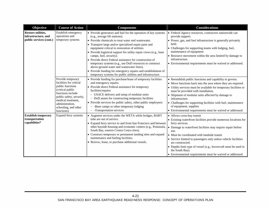
4-21
SAN FRANCISCO BAY AREA EARTHQUAKE READINESS RESPONSE: CONCEPT OF OPERATIONS PLAN
Objective Course of Action Components Considerations Restore utilities, infrastructure, and public services (cont.)
Establish emergency operations and temporary systems
• Provide generators and fuel for the operation of key systems (e.g., sewage lift stations).
• Provide chemicals to treat water and wastewater. • Transport large and/or specialized repair parts and
equipment critical to restoration of utilities. • Provide logistical support for utility repair crews (e.g., base
camps, fuel, security). • Provide direct Federal assistance for construction of
temporary systems (e.g., use DoD resources to construct above-ground water and wastewater lines).
• Provide funding for emergency repairs and establishment of temporary systems for public utilities and infrastructure.
• Federal Agency resources, contractors nationwide can provide support.
• Power, gas, and fuel infrastructure is generally privately held.
• Challenges for supporting teams with lodging, fuel, maintenance of equipment
• Resource movement within the area limited by damage to infrastructure.
• Environmental requirements must be waived or addressed.
Provide temporary facilities for critical public functions (critical public functions include public safety, security, medical treatment, administration, schooling, and other functions)
• Provide funding for purchase/lease of temporary facilities and emergency repairs.
• Provide direct Federal assistance for temporary facilities/repairs: − USACE delivery and setup of modular units − DoD assets for constructing temporary facilities
• Provide services for public safety, other public employees: − -Base camps or other temporary lodging − -Transportation services
• Reestablish public functions and capability to govern. • Move functions back into the area where they are required. • Utility services must be available for temporary facilities or
must be provided with installation. • Shipment of modular units affected by damage to
infrastructure. • Challenges for supporting facilities with fuel, maintenance
of equipment, supplies • Environmental requirements must be waived or addressed.
Establish temporary transportation capabilities*
Expand ferry systems • Augment services under the WETA while bridges, BART tube are out of service.
• Expand ferry service to and from San Francisco and between other bayside housing and economic centers (e.g., Peninsula, South Bay, eastern Contra Costa cities).
• Construct temporary or permanent landing sites and expand maintenance and fueling facilities.
• Borrow, lease, or purchase additional vessels.
• Allows cross-bay transit • Existing waterfront facilities provide numerous locations for
ferry services. • Damage to waterfront facilities may require repair before
use. • Must be coordinated with landside transit • Service limited to passengers only unless vehicle facilities
are constructed. • Depths limit type of vessel (e.g., hovercraft must be used in
the South Bay). • Environmental requirements must be waived or addressed.
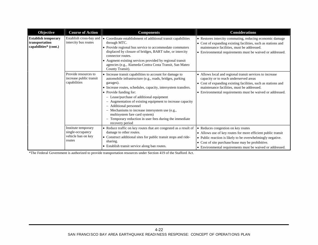
4-22
SAN FRANCISCO BAY AREA EARTHQUAKE READINESS RESPONSE: CONCEPT OF OPERATIONS PLAN
Objective Course of Action Components Considerations Establish temporary transportation capabilities* (cont.)
Establish cross-bay and intercity bus routes
• Coordinate establishment of additional transit capabilities through MTC.
• Provide regional bus service to accommodate commuters displaced by closure of bridges, BART tube, or intercity connector routes.
• Augment existing services provided by regional transit agencies (e.g., Alameda-Contra Costa Transit, San Mateo County Transit).
• Restores intercity commuting, reducing economic damage • Cost of expanding existing facilities, such as stations and
maintenance facilities, must be addressed. • Environmental requirements must be waived or addressed.
Provide resources to increase public transit capabilities
• Increase transit capabilities to account for damage to automobile infrastructure (e.g., roads, bridges, parking garages).
• Increase routes, schedules, capacity, intersystem transfers. • Provide funding for: − Lease/purchase of additional equipment − Augmentation of existing equipment to increase capacity − Additional personnel − Mechanisms to increase intersystem use (e.g.,
multisystem fare card system) − Temporary reduction in user fees during the immediate
recovery period
• Allows local and regional transit services to increase capacity or to reach underserved areas
• Cost of expanding existing facilities, such as stations and maintenance facilities, must be addressed.
• Environmental requirements must be waived or addressed.
Institute temporary single-occupancy vehicle ban on key routes
• Reduce traffic on key routes that are congested as a result of damage to other routes.
• Construct additional sites for public transit stops and ride-sharing.
• Establish transit service along ban routes.
• Reduces congestion on key routes • Allows use of key routes for more efficient public transit • Public reaction is likely to be overwhelmingly negative. • Cost of site purchase/lease may be prohibitive. • Environmental requirements must be waived or addressed.
*The Federal Government is authorized to provide transportation resources under Section 419 of the Stafford Act.
4-23
SAN FRANCISCO BAY AREA EARTHQUAKE READINESS RESPONSE: CONCEPT OF OPERATIONS PLAN
Table 3. Execution Schedule
Table redacted from public release.
Sensitive information for official use only

4-24
SAN FRANCISCO BAY AREA EARTHQUAKE READINESS RESPONSE: CONCEPT OF OPERATIONS PLAN
This page is intentionally left blank.
5-1
SAN FRANCISCO BAY AREA EARTHQUAKE READINESS RESPONSE: CONCEPT OF OPERATIONS PLAN
5 Incident Coordination This section provides a general discussion of coordination, communication, and oversight with regard to the joint State/Federal response. All activities will be consistent with the State Emergency Plan, SEMS, and NIMS.
5.1 Coordination As described in Section 4.2.3, State and Federal actions in support of field-level response are coordinated through the joint State/Federal organization under the direction of the Unified Coordination Group. The Unified Coordination Group is initially formed at the SOC upon arrival of the Federal IMAT and then deploys to the JFO when that facility can function adequately to support response and recovery operations (the move is targeted for E+72 hours). Joint State/Federal operations are organized according to Incident Command System principles.
While it is understood that the State’s SEMS provides for the orderly submittal of requests for supplemental intrastate and interstate mutual aid assistance from local Operational Area organizations to one of three State Regional Emergency Operations Centers, the response to a catastrophic San Francisco Bay Area earthquake will require a greater level of interface between the Operational Areas and the Unified Coordination Group heading up the joint State/Federal IMAT organization. The unique coordination and communication requirements will be met by deploying “Division Supervisors” to the impacted Operational Area Emergency Operations Centers.
The deployment of division supervisors does not replace the existing SEMS State-level coordinating structure, but rather provides a temporary, earthquake-specific direct line of communication between the Operational Area EOCs and the joint State/Federal IMAT Operations Section. The division supervisors will serve as the single point of contact for the request and acquisition of supplemental Federal resources for the impacted Operational Area EOCs.
Refer to Annex A for additional details regarding the joint State/Federal organization.
5.1.1 Coordination with Other State and Federal Agencies
Supporting State agencies, Federal Agencies (including agencies organized according to ESFs1
1 Refer to the NRF, dated January 2008, and supporting ESF annexes for a description of each ESF.
), NGOs, private-sector organizations, and volunteers may be directly integrated into the joint State/Federal organization or designated as resources through the IAP process for specific assignments. State and Federal mission coordinators, working under the direction of the joint Operations Section chiefs, provide mission assignments (Federal Agencies) or mission taskings (State agencies) as required. A liaison officer serves as the Unified Coordination Group’s primary point of contact with agencies not directly integrated into the joint State/Federal organization and coordinates with agency representatives who have responsibility for monitoring the involvement of these agencies in the operation.
5-2
SAN FRANCISCO BAY AREA EARTHQUAKE READINESS RESPONSE: CONCEPT OF OPERATIONS PLAN
State and Federal agencies may respond to the earthquake under their own authorities. Once the Unified Coordination Group is established, these activities must be coordinated with the joint State/Federal organization so that they can be accounted for in the IAP process. To the extent possible, sustained operations should be folded into the joint State/Federal response through the mission tasking/mission assignment processes.
5.1.2 Coordination with Local and Regional Governments California’s system for managing emergencies and for providing support and resources to local governments is governed by the State Emergency Plan and SEMS, with the Regional Emergency Coordination Plan providing specific information for the Bay Area.
1
In accordance with SEMS, requests for resources must be made to the next level (for example, from a city to an Operational Area); requests for assistance of State agencies, the Emergency Management Assistance Compact (EMAC), or the Federal Government must be made at the State level through OES. Consequently, within the Unified Coordination Group, OES maintains responsibility for:
In general, the Operational Areas, mutual aid coordinators, and other local and regional entities transmit information and resource requests via the Response Information Management System (RIMS), although other mechanisms may be used by mutual aid coordinators or if the State’s communications system is compromised.
Maintaining coordination with the Operational Areas and other local and regional entities, such as MTC and WETA, and receiving information and requests for resources from these entities
Coordinating mutual aid requests and the flow of resources through the mutual aid system
Brokering resource requests among Operational Areas within the region or among regions
Tasking State agencies to provide resources in response to local government requests
Obtaining resources from other States through State-to-State mutual aid and EMAC
As described in Annex A, joint State and Federal division supervisors deploy to the Operational Areas to support integration and utilization of resources at the local level. A Federal division supervisor and State division supervisor or liaison will jointly deploy to the Operational Area EOCs and coordinate with the EOC Director. The joint State/Federal division supervisors provide a direct means of coordination and assistance with situational awareness and formulation of resource requests. Normally, in accordance with SEMS, Operational Area resource requests go through the State Regional Operations Center in Oakland to the State Operations Center in Rancho Cordova, California. The joint State/Federal division supervisors will support in the submittal and coordination of resource requests following the earthquake by providing forward located State/Federal representation at the impacted Operational Areas.
Refer to Annex A for additional information on coordination with local and regional governments. 1 For details, refer to the State Emergency Plan, dated September 2005; SEMS Guidelines, dated September 2006; and the Regional Emergency Coordination Plan, dated March 2008.
5-3
SAN FRANCISCO BAY AREA EARTHQUAKE READINESS RESPONSE: CONCEPT OF OPERATIONS PLAN
5.1.3 Coordination of State and Federal Military Resources CANG may be tasked by OES (through a mission task) to provide resources in support of the response. California may also request support from National Guard units in other States via EMAC. CANG and National Guard personnel from other States will respond in a Title 32 duty status and remain under the control of the Governor via the Adjutant General. Their operations in the field will be directed by one or more Task Force Commanders or Joint Task Force Commanders operating under proper State authority.
Potential missions for CANG and National Guard personnel from other States include:
Ground, air, and water transportation Support to law enforcement agencies/security Medical services Communications Engineering Water purification Logistics management/distribution Damage assessment/aerial reconnaissance
DoD may be tasked by FEMA (through a mission assignment) to provide resources in a Title 10 duty status for Civil Support operations. Once these assignments have been issued, DoD personnel carrying out missions will remain under the control of the Secretary of Defense via U.S. Northern Command. Their operations in the field will be directed by one or more Task Force Commanders or Joint Task Force Commanders operating under proper Federal authority. The defense coordinating officer (DCO) will serve as the link between the Unified Coordination Group and the Task Force Commander.
Potential missions for DoD personnel in a Title 10 status are similar to those of the National Guard except for the limits on domestic law enforcement imposed by the Posse Comitatus Act of 1878. Due to their greater capabilities, DoD organizations may be tasked to deliver extraordinary services in areas such as naval vessel power generation/water purification, enhanced field-level medical services, and airlift.
Neither State nor Federal military authorities have incident command responsibilities, but as described above, provide command and control for military resources through one or more task forces or joint task forces. State and Federal military resources will be coordinated with civilian resources to achieve unity of effort through the IAP process carried out under the oversight of the Unified Coordination Group.
5.1.4 Coordination with Tribal Governments There are five federally-recognized tribes in the 10-county Bay Area, all in Sonoma County. Some have tribal lands or own property. There are a number of nonfederally-recognized tribes in the region. Within SEMS, tribal governments may coordinate their efforts and requests for resources through Operational Area EOCs in their respective counties. Consequently, coordination with these tribes follows that of coordination with other local governments, as described above.
5-4
SAN FRANCISCO BAY AREA EARTHQUAKE READINESS RESPONSE: CONCEPT OF OPERATIONS PLAN
5.1.5 Coordination with Other States OES is responsible for procuring out-of-State resources through either State-to-State mutual aid or EMAC. Initially, this process occurs at the SOC where decisions to request resources from other States or through EMAC are made based on whether local, mutual aid, or State agency resources are otherwise available. As the joint State/Federal organization shifts to the JFO, the decision to request resources from other States or through EMAC is made by the Operations and/or Logistics sections as part of the process for evaluating the availability of resources to carry out operational objectives. OES establishes an EMAC coordinator in the Operations or Logistics section, or both, to request resources through EMAC, once the section chiefs make the decision to do so.
5.2 Communication This section provides a general discussion of incident communications. Refer to Annex C for additional information.
5.2.1 Emergency Communications The earthquake is expected to cause significant damage to public safety and commercial communications systems. Additionally, the deployment of resources to the Bay Area and nearby regions will necessitate the establishment of a communication system to support the response. As described in Section 4.2.5, these circumstances require immediate deployment of communications assets, and the establishment of interoperable emergency communications is a priority for the first 72 hours after the earthquake.
Initial communication restoration targets will focus on the establishment of communication capabilities for emergency response operations, including satellite, voice-radio, and mobile/cellular systems. Communications will be established to link components of the joint State/Federal organization, including the SOC, JFO, National Logistic Staging Areas, other staging areas, and response teams in the field. Federal mobile communications assets, such as MERS and DoD resources, will be deployed in support of this effort. These assets will also be used to provide support for State and local communications systems as required.
Annex C, Tab 3, provides additional details on joint Federal/State efforts to establish and sustain emergency communications systems.
5.2.2 Intelligence and Information Sharing Protocols The Unified Coordination Group formulates joint objectives and implements a joint IAP process based on a common operating picture. The common operating picture is achieved through a formal reporting methodology managed by the joint Planning Section. The joint Planning Section implements an Information Plan based on defined Essential Elements of Information (EEI) to provide the basis for gathering and analyzing available information. EEI for the earthquake are provided in Annex B.
5.2.3 External Communications At the State level, OES is responsible for developing and releasing information about emergency operations to the news media, to personnel involved in the operation, and to other appropriate agencies and organizations. Additional support may be drawn from other State agencies, volunteers, or participants in the Public Information Officer Mutual Aid Program.
5-5
SAN FRANCISCO BAY AREA EARTHQUAKE READINESS RESPONSE: CONCEPT OF OPERATIONS PLAN
The OES PIO at the SOC initially activates and directs public information procedures. Coordination with Federal, State, and local entities is necessary to ensure accuracy and consistency in the delivery of emergency public information messages.
Immediately following the earthquake, the DHS Assistant Secretary of Public Affairs activates ESF #15, External Affairs. ESF #15 provides operational, strategic, logistical, and administrative support for external affairs related to Federal operations. ESF #15 is responsible for public and congressional affairs; coordination of State, local, and tribal affairs; community relations; international affairs; and coordination with private sector.
The emergency public information effort focuses on developing and delivering lifesaving, life-preserving messages and other disaster and program information to the affected population. Refer to Annex C, Tab 4, for more detailed information regarding External Affairs.
5.3 Oversight Oversight for the response to the earthquake occurs in accordance with the State Emergency Plan, SEMS, NIMS, and the NRF. Key oversight concepts related to the earthquake response are covered under Section 6.3 of the California Catastrophic Incident Base Plan CONOP.
5.3.1 Field-Level Response At the field response level, emergency response personnel and resources, under the command of an appropriate authority, carry out tactical decisions and activities in direct response to the earthquake. In general, the incident commander is a local government official, although other entities may have specific authority to assume that role (e.g., CHP assumes Incident Command for hazardous materials incidents on State highways). A Unified Command or Area Command may be formed, depending on the specific circumstances of the incident.
5.3.2 Local Governments Local governments include cities, counties, and special districts. Local governments are responsible for the management and coordination of the emergency response and recovery activities within their jurisdictions. State entities, such as the University of California and California State University campuses in the Bay Area, also have responsibility to manage and coordinate the overall emergency response and recovery activities within their jurisdictions. Similarly, although not considered local governments, Federal entities, such as the National Park Service, also have responsibility to manage and coordinate the response within their jurisdictions.
As described in Section 5.1.5, tribal entities function as local governments within SEMS.
5.3.3 Operational Areas The Operational Area manages and coordinates information, resources, and priorities among local governments within the Operational Area and serves as the coordination and communication link between the local and regional governments. While the Operational Area encompasses the entire area within the county, it does not necessarily mean that the county government manages and coordinates the response and recovery activities within that county. The governing bodies of the county and the political subdivisions within the county make the decision on organization and structure within the Operational Area.

5-6
SAN FRANCISCO BAY AREA EARTHQUAKE READINESS RESPONSE: CONCEPT OF OPERATIONS PLAN
5.3.4 Region The regional level manages and coordinates information and resources among Operational Areas within the region,
1
5.3.5 State
and between the Operational Areas and the State level. The regional level also coordinates overall State agency support for emergency response activities within the region. As stated in Section 2.3, the REOC will not be functional as a result of the earthquake, but OES will manage these functions at the State level.
The State level of SEMS tasks and coordinates State resources in response to the requests from the regional level and coordinates mutual aid among the mutual aid regions and between the regional level and State level. In accordance with the California Emergency Services Act and the State Emergency Plan, the Governor directs all State agencies to use their resources in response to the incident; and the OES Director is responsible for coordination of the activities of all State agencies. These agencies, while operating under their respective authorities, take action in accordance with the objectives identified by the Unified Coordination Group.
5.3.6 Federal The Federal Government provides resources and support in response to requests from State. In accordance with the NRF, the Federal Coordinating Officer, on behalf of the President, is responsible for coordinating the Federal response. Federal Agencies and Departments, working through ESFs and mission assignments from FEMA, take action in accordance with the objectives identified by the Unified Coordination Group.
Federal resources may be placed under the control of the field-level Incident Command. Some resources, such as resources at National Logistic Staging Areas or teams responsible for implementing Federal recovery programs, may remain under the control of the Unified Coordination Group.
5.3.7 Unified Coordination Group The Unified Coordination Group provides a mechanism for multiple agencies to work together with common objectives. The Unified Coordination Group effectively manages the joint State/Federal response to the earthquake and ensures that all decisions will be based on mutually agreed-upon objectives. To achieve the common objective of effective incident management, the Unified Coordination Group directs coordinated combined State and Federal operations using Unified Command principles.
The Unified Coordination Group oversees the development of joint operational objectives based on priorities set by the Governor and the President, input from local governments and others identifying needs, and situational awareness. Objectives identified by the Unified Coordination Group are incorporated into the joint IAP process and disseminated to the staff through the IAP. Once these objectives have been communicated, joint section chiefs make decisions and take actions necessary to support these objectives.
1 See Figure A-1 for a map showing the OES Coastal Region, which includes the 10 counties in the Bay Area. The 10 Bay Area counties also fall within Mutual Aid Region II.
5-7
SAN FRANCISCO BAY AREA EARTHQUAKE READINESS RESPONSE: CONCEPT OF OPERATIONS PLAN
5.3.8 Military Resources As described above, DoD may be tasked by FEMA (through a mission assignment) and CANG may be tasked by OES (through a mission task) to provide resources in support of the response. However, once these assignments have been issued, DoD and CANG elements carrying out missions remain under the control of the Secretary of Defense and the Governor, respectively. Their operations in the field are directed by one or more task forces or joint task forces operating under proper State and Federal authority. State and Federal military resources will be coordinated with civilian resources to achieve unity of effort through the IAP process carried out under the oversight of the Unified Coordination Group.

5-8
SAN FRANCISCO BAY AREA EARTHQUAKE READINESS RESPONSE: CONCEPT OF OPERATIONS PLAN
This page is intentionally left blank.
6-1
SAN FRANCISCO BAY AREA EARTHQUAKE READINESS RESPONSE: CONCEPT OF OPERATIONS PLAN
6 Plan Maintenance FEMA Region IX, Disaster Operations Division, is responsible for the maintenance, update, and dissemination of the CONPLAN. Working with OES, FEMA will evaluate the CONPLAN biannually and modify the plan on the basis of changes in laws, regulations, policies, State or Federal systems, or procedures, and after action reports and lessons learned from major activations or exercises. FEMA and OES will distribute the revised document to the appropriate local, State, Federal, and private-sector entities.

6-2
SAN FRANCISCO BAY AREA EARTHQUAKE READINESS RESPONSE: CONCEPT OF OPERATIONS PLAN
This page is intentionally left blank.
A-1
ANNEX A: INCIDENT TASK ORGANIZATION AND COORDINATION
ANNEX A: INCIDENT TASK ORGANIZATION AND COORDINATION
Information redacted from public release.
Sensitive information for official use only

A-2
ANNEX A: INCIDENT TASK ORGANIZATION AND COORDINATION
This page is intentionally left blank.
B-1
ANNEX B: INTELLIGENCE AND SITUATIONAL AWARENESS
ANNEX B: INTELLIGENCE AND SITUATIONAL AWARENESS Rapid evaluation of the earthquake impact is essential as a coordinated appraisal of the intensity and extent of the incident is critical to supporting decisionmaking. The flow of information from local jurisdictions and Operational Area Emergency Operations Centers (EOCs) to the Governor’s Office of Emergency Services (OES), the Federal Emergency Management Agency (FEMA), and the Joint Field Office (JFO) will require a disciplined approach to facilitate effective development of a common operating picture and to compensate for the earthquake-driven degradation of the communications system.
B.1 Potential Sources of Information Example sources of information include the following:
The California State Warning Center
Local, tribal, and private-sector representatives at the field level
Information obtained by OES from local and regional agencies, Operational Area EOCs, mutual aid coordinators, post-Earthquake Information Clearinghouse, and other entities through the Response Information Management System (RIMS) and other means of communication
Earthquake data from :
− National Earthquake Information Center, run by the U.S. Geological Survey (USGS)
− Seismological laboratories at the University of California-Berkeley and California Institute of Technology in Pasadena California Integrated Seismic Network, which includes the California Geological Survey, the USGS, OES, the University of California-Berkeley and the California Institute of Technology
− California Geological Survey
− Department of Water Resources (DWR) instrumentation along the State Water Project
− Earthquake Information Clearinghouse,1
1 The Earthquake Information Clearinghouse is a cooperative effort among the USGS, the Earthquake Engineering Research
Institute, the National Science Foundation, FEMA, the California Seismic Safety Commission, and various research entities. Clearinghouse teams deploy to the affected areas to collect data and assess the impact of the earthquake, particularly in terms of geology, structural damage, and impacts to lifelines. They may provide information that can be used to inform situational awareness.
which may provide field observations within a few hours of the earthquake as research teams reach the affected area
B-2
ANNEX B: INTELLIGENCE AND SITUATIONAL AWARENESS
Predictive modeling. Potential sources include:
− Loss estimation models based on actual earthquake data prepared using HAZUS-MH by the USGS, OES, FEMA, and others1
− Predictive modeling by the U.S. Army Corps of Engineers of potential commodity requirements based on the magnitude of the earthquake
Department Operations Centers of State agencies, such as the Joint Emergency Operations Center run by the California Department of Public Health and the California Emergency Medical Services Authority
Emergency operations centers of Federal Agencies
State and Federal assessment teams such as State/Federal Preliminary Damage Assessment teams
Reports from State and Federal response teams in the field
Media reports
Generally, the most accurate information is obtained from those on the ground, closest to the potential or actual incident site. Incident commanders and the planning sections within their incident management teams are often the most reliable sources of information. Planning sections at various levels analyze the information and turn that information into useful intelligence for managers and senior leaders. This step is vital in terms of providing data necessary for decisionmakers to prioritize activities and the deployment and employment of critical, but often limited, resources.
B.2 Intelligence Collection and Utilization At the State and Federal levels, initial efforts to gain situational awareness will occur at the State Operations Center (SOC)2
1 OES, FEMA, the USGS, and other entities may initiate HAZUS modeling at the same time. The Shake Maps produced
immediately following the earthquake may be imported into HAZUS; and within 1 to 2 hours HAZUS may generate initial loss estimates and to projections of demand for medical treatment, care and shelter, mass fatality operations, and logistical support. In general, FEMA will defer to HAZUS runs produced by OES for initial estimates.
and at separate Federal operations centers. Once the Unified Coordination Group is formed and the integrated State/Federal organization is established at the JFO, responsibility for intelligence collection and utilization is assumed by the joint Planning Section. The Situation Unit of the Planning Section will develop an Information Collection Plan for gathering information from the sources outlined above in as comprehensive and consistent manner as the circumstances of the earthquake will allow. The Planning Section will compile sources of information and provide validation and analysis to develop a common operating picture that will be shared with local government, State, and Federal agencies operations centers and elected officials.
2 As described above, it is assumed that both the OES Regional Emergency Operations Center and the FEMA Regional Response Coordination Center, both in Oakland, are not operational as a result of the earthquake.
B-3
ANNEX B: INTELLIGENCE AND SITUATIONAL AWARENESS
Because the extent of damage will not be uniform throughout the 10 counties, situational awareness within Operational Areas will not be consistent and the pace of response operations will vary. During the early stages of response, requirements will far exceed resources, requiring that the Unified Coordination Group prioritize resource allocation consistent with capabilities. A concern for the Unified Coordination Group will be to ensure that sufficient resources are available for those areas where situational awareness is poorest and damage is likely the most severe.
B.3 Essential Elements of Information (EEIs) Essential Elements of Information (EEIs) are the critical items of information required by senior leaders within a particular timeframe that, when related to other available information and intelligence, may be used to reach a logical decision.
Generally, EEIs revolve around critical data that are focused on the operational objectives of established by the Unified Coordination Group. For example, EEIs necessary during immediate response efforts may relate to the status of medical facilities, number of patients by categories, status of transportation systems, and status of utility infrastructure. To assist the Unified Coordinating Group with formulation of appropriate joint objectives based on a common operating picture, a formal reporting methodology must be provided to all levels, including Operational Areas, branches, divisions, and any State or Federal organizations, such as State and Federal assessment teams, in order to focus collection efforts on EEIs to prioritize the kinds of information required.
A compilation of EEIs and an earthquake-specific information collection plan is provided in Table B-1.
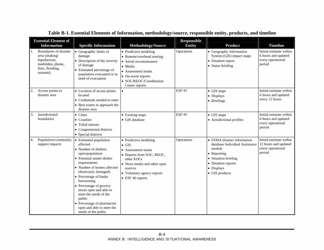
B-4
ANNEX B: INTELLIGENCE AND SITUATIONAL AWARENESS
Table B-1. Essential Elements of Information, methodology/source, responsible entity, products, and timeline Essential Element of
Information Specific Information Methodology/Source Responsible
Entity Product Timeline 1. Boundaries of disaster
area (shaking/ liquefaction, landslides, plume, fires, flooding, tsunami)
• Geographic limits of damage
• Description of the severity of damage
• Estimated percentage of population evacuated or in need of evacuation
• Predictive modeling • Remote/overhead sensing • Aerial reconnaissance • Media • Assessment teams • On-scene reports • SOC/REOC/Coordination
Center reports
Operations • Geographic Information System (GIS) impact maps
• Situation report • Status briefing
Initial estimate within 6 hours and updated every operational period
2. Access points to disaster area
• Location of access points located
• Credentials needed to enter • Best routes to approach the
disaster area
• ESF #1 • GIS maps • Displays • Briefings
Initial estimate within 6 hours and updated every 12 hours
3. Jurisdictional boundaries
• Cities • Counties • Tribal nations • Congressional districts • Special districts
• Existing maps • GIS database
ESF #5 • GIS maps • Jurisdictional profiles
Initial estimate within 6 hours and updated every operational period
4. Population/community support impacts
• Estimated population affected
• Number of shelters open/population
• Potential unmet shelter requirements
• Number of homes affected (destroyed, damaged)
• Percentage of banks functioning
• Percentage of grocery stores open and able to meet the needs of the public
• Percentage of pharmacies open and able to meet the needs of the public
• Predictive modeling • GIS • Assessment teams • Reports from SOC, REOC,
other EOCs • News media and other open
sources • Voluntary agency reports • ESF #6 reports
Operations • FEMA disaster information database Individual Assistance module
• Reporting • Situation briefing • Situation reports • Displays • GIS products
Initial estimate within 12 hours and updated every operational period
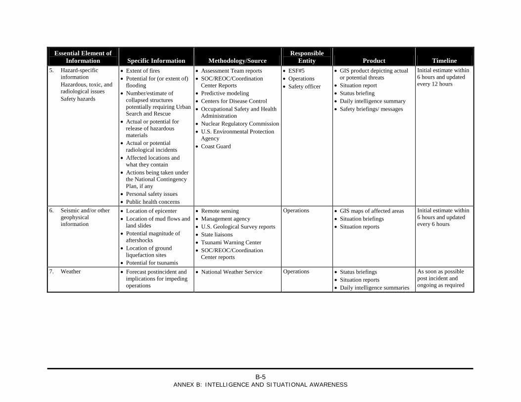
B-5
ANNEX B: INTELLIGENCE AND SITUATIONAL AWARENESS
Essential Element of Information Specific Information Methodology/Source
Responsible Entity Product Timeline
5. Hazard-specific information
Hazardous, toxic, and radiological issues
Safety hazards
• Extent of fires • Potential for (or extent of)
flooding • Number/estimate of
collapsed structures potentially requiring Urban Search and Rescue
• Actual or potential for release of hazardous materials
• Actual or potential radiological incidents
• Affected locations and what they contain
• Actions being taken under the National Contingency Plan, if any
• Personal safety issues • Public health concerns
• Assessment Team reports • SOC/REOC/Coordination
Center Reports • Predictive modeling • Centers for Disease Control • Occupational Safety and Health
Administration • Nuclear Regulatory Commission • U.S. Environmental Protection
Agency • Coast Guard
• ESF#5 • Operations • Safety officer
• GIS product depicting actual or potential threats
• Situation report • Status briefing • Daily intelligence summary • Safety briefings/ messages
Initial estimate within 6 hours and updated every 12 hours
6. Seismic and/or other geophysical information
• Location of epicenter • Location of mud flows and
land slides • Potential magnitude of
aftershocks • Location of ground
liquefaction sites • Potential for tsunamis
• Remote sensing • Management agency • U.S. Geological Survey reports • State liaisons • Tsunami Warning Center • SOC/REOC/Coordination
Center reports
Operations • GIS maps of affected areas • Situation briefings • Situation reports
Initial estimate within 6 hours and updated every 6 hours
7. Weather • Forecast postincident and implications for impeding operations
• National Weather Service Operations • Status briefings • Situation reports • Daily intelligence summaries
As soon as possible post incident and ongoing as required
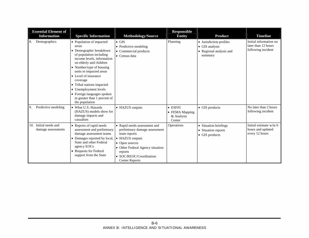
B-6
ANNEX B: INTELLIGENCE AND SITUATIONAL AWARENESS
Essential Element of Information Specific Information Methodology/Source
Responsible Entity Product Timeline
8. Demographics • Population of impacted areas
• Demographic breakdown of population including income levels, information on elderly and children
• Number/type of housing units in impacted areas
• Level of insurance coverage
• Tribal nations impacted • Unemployment levels • Foreign languages spoken
in greater than 1 percent of the population
• GIS • Predictive modeling • Commercial products • Census data
Planning • Jurisdiction profiles • GIS analysis • Regional analysis and
summary
Initial information no later than 12 hours following incident
9. Predictive modeling • What U.S.-Hazards (HAZUS) models show for damage impacts and casualties
• HAZUS outputs • ESF#5 • FEMA Mapping
& Analysis Center
• GIS products No later than 2 hours following incident
10. Initial needs and damage assessments
• Reports of rapid needs assessment and preliminary damage assessment teams
• Damages reported by local, State and other Federal agency EOCs
• Requests for Federal support from the State
• Rapid needs assessment and preliminary damage assessment team reports
• HAZUS outputs • Open sources • Other Federal Agency situation
reports • SOC/REOC/Coordination
Center Reports
Operations • Situation briefings • Situation reports • GIS products
Initial estimate w/in 6 hours and updated every 12 hours
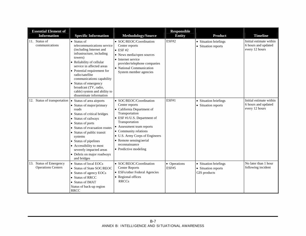
B-7
ANNEX B: INTELLIGENCE AND SITUATIONAL AWARENESS
Essential Element of Information Specific Information Methodology/Source
Responsible Entity Product Timeline
11. Status of communications
• Status of telecommunications service (including Internet and infrastructure, including towers)
• Reliability of cellular service in affected areas
• Potential requirement for radio/satellite communications capability
• Status of emergency broadcast (TV, radio, cable) system and ability to disseminate information
• SOC/REOC/Coordination Center reports
• ESF #2 • News media/open sources • Internet service
provider/telephone companies • National Communication
System member agencies
ESF#2 • Situation briefings • Situation reports
Initial estimate within 6 hours and updated every 12 hours
12. Status of transportation • Status of area airports • Status of major/primary
roads • Status of critical bridges • Status of railways • Status of ports • Status of evacuation routes • Status of public transit
systems • Status of pipelines • Accessibility to most
severely impacted areas • Debris on major roadways
and bridges
• SOC/REOC/Coordination Center reports
• California Department of Transportation
• ESF #1/U.S. Department of Transportation
• Assessment team reports • Community relations • U.S. Army Corps of Engineers • Remote sensing/aerial
reconnaissance • Predictive modeling
ESF#1 • Situation briefings • Situation reports
Initial estimate within 6 hours and updated every 12 hours
13. Status of Emergency Operations Centers
• Status of local EOCs • Status of State SOC/REOC • Status of agency EOCs • Status of RRCC • Status of IMAT Status of back-up region RRCC
• SOC/REOC/Coordination Center Reports
• ESFs/other Federal Agencies • Regional offices RRCCs
• Operations ESF#5
• Situation briefings • Situation reports GIS products
No later than 1 hour following incident
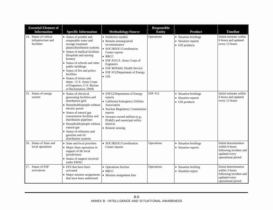
B-8
ANNEX B: INTELLIGENCE AND SITUATIONAL AWARENESS
Essential Element of Information Specific Information Methodology/Source
Responsible Entity Product Timeline
14. Status of critical infrastructure and facilities
• Status of potable and nonpotable water and sewage treatment plants/distribution systems
• Status of medical facilities (hospitals and nursing homes)
• Status of schools and other public buildings
• Status of fire and police facilities
• Status of levees and dams—U.S. Army Corps of Engineers, U.S. Bureau of Reclamation, DWR
• Predictive models • Remote sensing/aerial
reconnaissance • SOC/REOC/Coordination
Center reports • RRCC • ESF #3/U.S. Army Corps of
Engineers • ESF #8/Public Health Service • ESF #12/Department of Energy • GIS
Operations • Situation briefings • Situation reports • GIS products
Initial estimate within 6 hours and updated every 12 hours
15. Status of energy system
• Status of electrical generating facilities and distribution grid
• Households/people without electric power
• Status of natural gas transmission facilities and distribution pipelines
• Households/people without natural gas
• Status of refineries and gasoline and oil distribution systems
• ESF12/Department of Energy reports
• California Emergency Utilities Association
• Nuclear Regulatory Commission reports
• Investor-owned utilities (e.g., PG&E) and municipal utility districts
• Remote sensing
ESF #12 • Situation briefings • Situation reports • GIS products
Initial estimate within 6 hours and updated every 12 hours
16. Status of State and local operations
• State and local priorities • Major State operations in
support of the local jurisdictions
• Status of support received under EMAC
• SOC/REOC/Coordination Center reports
Operations • Situation briefings • Situation reports
Initial determination within 6 hours following incident and updated every operational period
17. Status of ESF activations
• EFS that have been activated
• Major mission assignments that have been authorized
• Operations Section • RRCC • Mission assignment lists
Operations • Situation briefing • Situation report
Initial determination within 3 hours following incident and updated every operational period
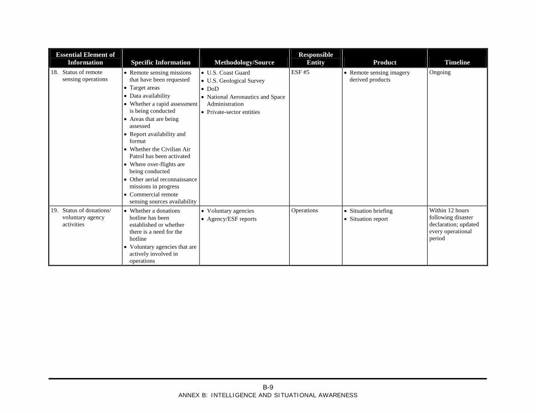
B-9
ANNEX B: INTELLIGENCE AND SITUATIONAL AWARENESS
Essential Element of Information Specific Information Methodology/Source
Responsible Entity Product Timeline
18. Status of remote sensing operations
• Remote sensing missions that have been requested
• Target areas • Data availability • Whether a rapid assessment
is being conducted • Areas that are being
assessed • Report availability and
format • Whether the Civilian Air
Patrol has been activated • Where over-flights are
being conducted • Other aerial reconnaissance
missions in progress • Commercial remote
sensing sources availability
• U.S. Coast Guard • U.S. Geological Survey • DoD • National Aeronautics and Space
Administration • Private-sector entities
ESF #5 • Remote sensing imagery derived products
Ongoing
19. Status of donations/ voluntary agency activities
• Whether a donations hotline has been established or whether there is a need for the hotline
• Voluntary agencies that are actively involved in operations
• Voluntary agencies • Agency/ESF reports
Operations • Situation briefing • Situation report
Within 12 hours following disaster declaration; updated every operational period
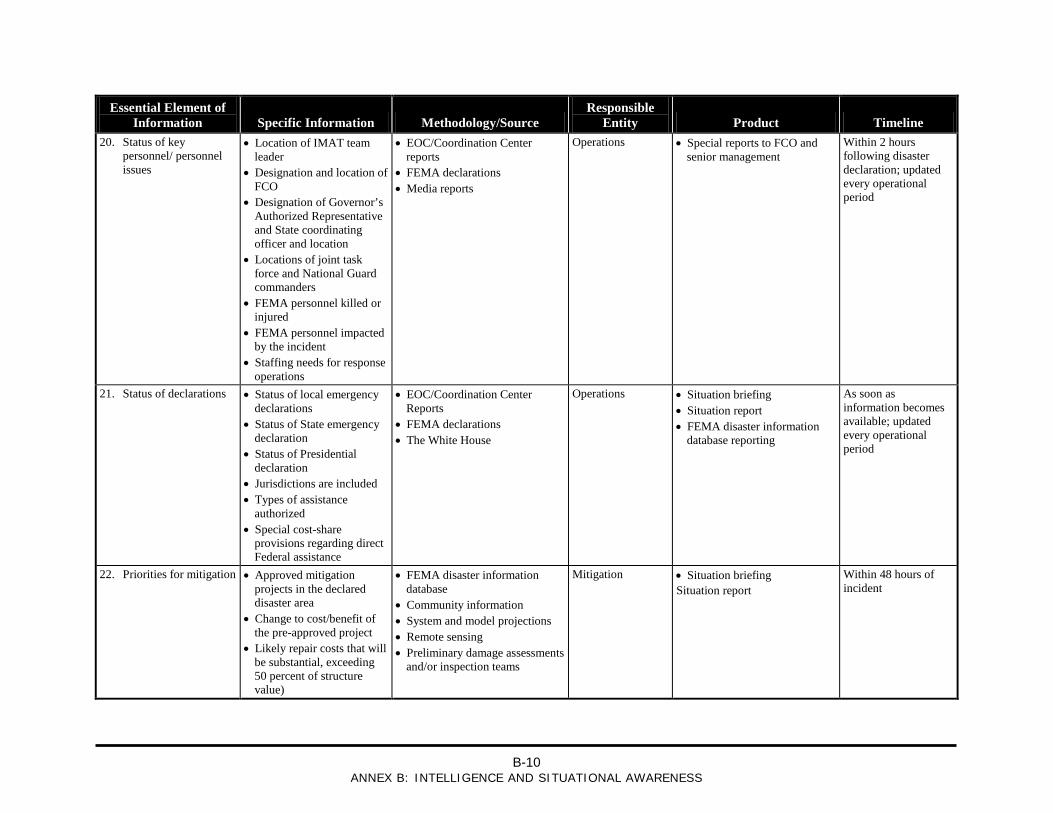
B-10
ANNEX B: INTELLIGENCE AND SITUATIONAL AWARENESS
Essential Element of Information Specific Information Methodology/Source
Responsible Entity Product Timeline
20. Status of key personnel/ personnel issues
• Location of IMAT team leader
• Designation and location of FCO
• Designation of Governor’s Authorized Representative and State coordinating officer and location
• Locations of joint task force and National Guard commanders
• FEMA personnel killed or injured
• FEMA personnel impacted by the incident
• Staffing needs for response operations
• EOC/Coordination Center reports
• FEMA declarations • Media reports
Operations • Special reports to FCO and senior management
Within 2 hours following disaster declaration; updated every operational period
21. Status of declarations • Status of local emergency declarations
• Status of State emergency declaration
• Status of Presidential declaration
• Jurisdictions are included • Types of assistance
authorized • Special cost-share
provisions regarding direct Federal assistance
• EOC/Coordination Center Reports
• FEMA declarations • The White House
Operations • Situation briefing • Situation report • FEMA disaster information
database reporting
As soon as information becomes available; updated every operational period
22. Priorities for mitigation • Approved mitigation projects in the declared disaster area
• Change to cost/benefit of the pre-approved project
• Likely repair costs that will be substantial, exceeding 50 percent of structure value)
• FEMA disaster information database
• Community information • System and model projections • Remote sensing • Preliminary damage assessments
and/or inspection teams
Mitigation • Situation briefing Situation report
Within 48 hours of incident
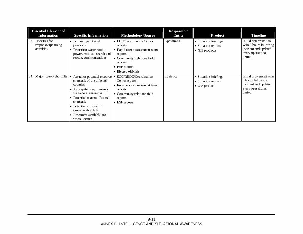
B-11
ANNEX B: INTELLIGENCE AND SITUATIONAL AWARENESS
Essential Element of Information Specific Information Methodology/Source
Responsible Entity Product Timeline
23. Priorities for response/upcoming activities
• Federal operational priorities
• Priorities: water, food, power, medical, search and rescue, communications
• EOC/Coordination Center reports
• Rapid needs assessment ream reports
• Community Relations field reports
• ESF reports • Elected officials
Operations • Situation briefings • Situation reports • GIS products
Initial determination w/in 6 hours following incident and updated every operational period
24. Major issues/ shortfalls • Actual or potential resource shortfalls of the affected counties
• Anticipated requirements for Federal resources
• Potential or actual Federal shortfalls
• Potential sources for resource shortfalls
• Resources available and where located
• SOC/REOC/Coordination Center reports
• Rapid needs assessment team reports
• Community relations field reports
• ESF reports
Logistics • Situation briefings • Situation reports • GIS products
Initial assessment w/in 6 hours following incident and updated every operational period

B-12
ANNEX B: INTELLIGENCE AND SITUATIONAL AWARENESS
This page is intentionally left blank.
C-1
ANNEX C: OPERATIONS
ANNEX C: OPERATIONS
Information redacted from public release.
Sensitive information for official use only.