Embed Size (px)
Citation preview
Sandy Subbasin
Agricultural Water Quality Management Area Plan
Developed by Sandy Subbasin Local Advisory Committee
with assistance from
Oregon Department of Agriculture
and Clackamas County Soil and Water Conservation District
Fourth Biennial Review April 18, 2012
Local Advisory Committee Members Robert Evatt, Chair James Burns Len Tobias Dan Ten Eyck, Vice Chair Susan Fry Dave Tobie Barb Adams Patrick Holt Deniece Tucker John Bergan Dianna Pope Chris Winters

Blank
Sandy Subbasin Agricultural Water Quality Management Area Plan (April 18, 2012) Page
I
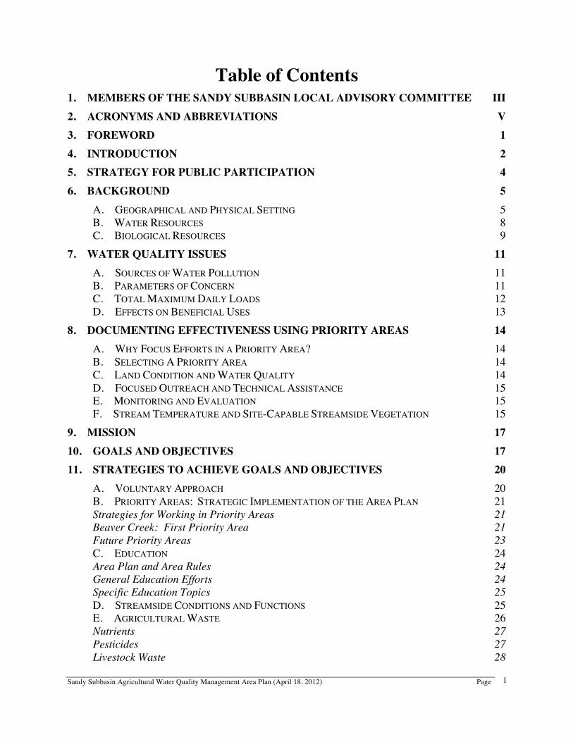
Table of Contents
1. MEMBERS OF THE SANDY SUBBASIN LOCAL ADVISORY COMMITTEE III 2. ACRONYMS AND ABBREVIATIONS V 3. FOREWORD 1 4. INTRODUCTION 2 5. STRATEGY FOR PUBLIC PARTICIPATION 4 6. BACKGROUND 5
A. GEOGRAPHICAL AND PHYSICAL SETTING 5 B. WATER RESOURCES 8 C. BIOLOGICAL RESOURCES 9
7. WATER QUALITY ISSUES 11 A. SOURCES OF WATER POLLUTION 11 B. PARAMETERS OF CONCERN 11 C. TOTAL MAXIMUM DAILY LOADS 12 D. EFFECTS ON BENEFICIAL USES 13
8. DOCUMENTING EFFECTIVENESS USING PRIORITY AREAS 14 A. WHY FOCUS EFFORTS IN A PRIORITY AREA? 14 B. SELECTING A PRIORITY AREA 14 C. LAND CONDITION AND WATER QUALITY 14 D. FOCUSED OUTREACH AND TECHNICAL ASSISTANCE 15 E. MONITORING AND EVALUATION 15 F. STREAM TEMPERATURE AND SITE-CAPABLE STREAMSIDE VEGETATION 15
9. MISSION 17 10. GOALS AND OBJECTIVES 17 11. STRATEGIES TO ACHIEVE GOALS AND OBJECTIVES 20
A. VOLUNTARY APPROACH 20 B. PRIORITY AREAS: STRATEGIC IMPLEMENTATION OF THE AREA PLAN 21 Strategies for Working in Priority Areas 21 Beaver Creek: First Priority Area 21 Future Priority Areas 23 C. EDUCATION 24 Area Plan and Area Rules 24 General Education Efforts 24 Specific Education Topics 25 D. STREAMSIDE CONDITIONS AND FUNCTIONS 25 E. AGRICULTURAL WASTE 26 Nutrients 27 Pesticides 27 Livestock Waste 28
Sandy Subbasin Agricultural Water Quality Management Area Plan (April 18, 2012) Page
II
Irrigation Tail-water 28 Sediment 29 Warning Signs That Agricultural Waste May Be Reaching Water 30 F. CONSERVATION PLANS 30 G. MANAGEMENT SYSTEMS 31 H. REGULATORY MEASURES 31 Prevention and Control Measures 31 Definitions 32 Resolution of Complaints and Enforcement Actions 33
12. ROLES AND RESPONSIBILITIES 34 A. AREA PLAN DEVELOPMENT 34 B. AREA PLAN IMPLEMENTATION 34 C. AGRICULTURE’S ROLE: AREA RULES, AREA PLAN, WATER QUALITY STANDARDS, AND
TMDLS 35 Individual Landowners’ Responsibility 35 Agriculture’s Collective Responsibility 35 Example: Streamside Vegetation, Riparian Rule, Area Plan, and Temperature TMDL 35 D. PESTICIDE MANAGEMENT 36
13. MONITORING AND EVALUATION 37 A. STATEWIDE MONITORING AND EVALUATION OF WATER QUALITY AND STREAMSIDE
CONDITIONS ON AGRICULTURAL LANDS 37 B. MONITORING, EVALUATION, AND MODIFICATION OF THE AREA PLAN 37 Water Quality Data Assessment 37 Land Condition Assessment 38 Implementation Activities Assessment 38 Area Plan and Area Rules Effectiveness Evaluation 38 Priority Area Monitoring and Evaluation 39
14. COSTS AND FINANCING 40 15. REFERENCES 41 16. APPENDICES 42
APPENDIX A: 2010 303(D) LIST AND TMDL STATUS OF WATER BODIES IN THE SANDY SUBBASIN AGRICULTURAL MANAGEMENT AREA 43
APPENDIX B: EDUCATIONAL AND TECHNICAL SERVICES FOR NATURAL RESOURCE AND FARM MANAGEMENT 48
Local Management Agencies (LMAs) and Local Advisory Committee (LAC) 48 Federal Agencies 48 State Agencies 48 Other Partners 49 APPENDIX C: ORS 468B.025 & 468B.050 - OREGON WATER POLLUTION CONTROL LAW 50
Sandy Subbasin Agricultural Water Quality Management Area Plan (April 18, 2012) Page
III
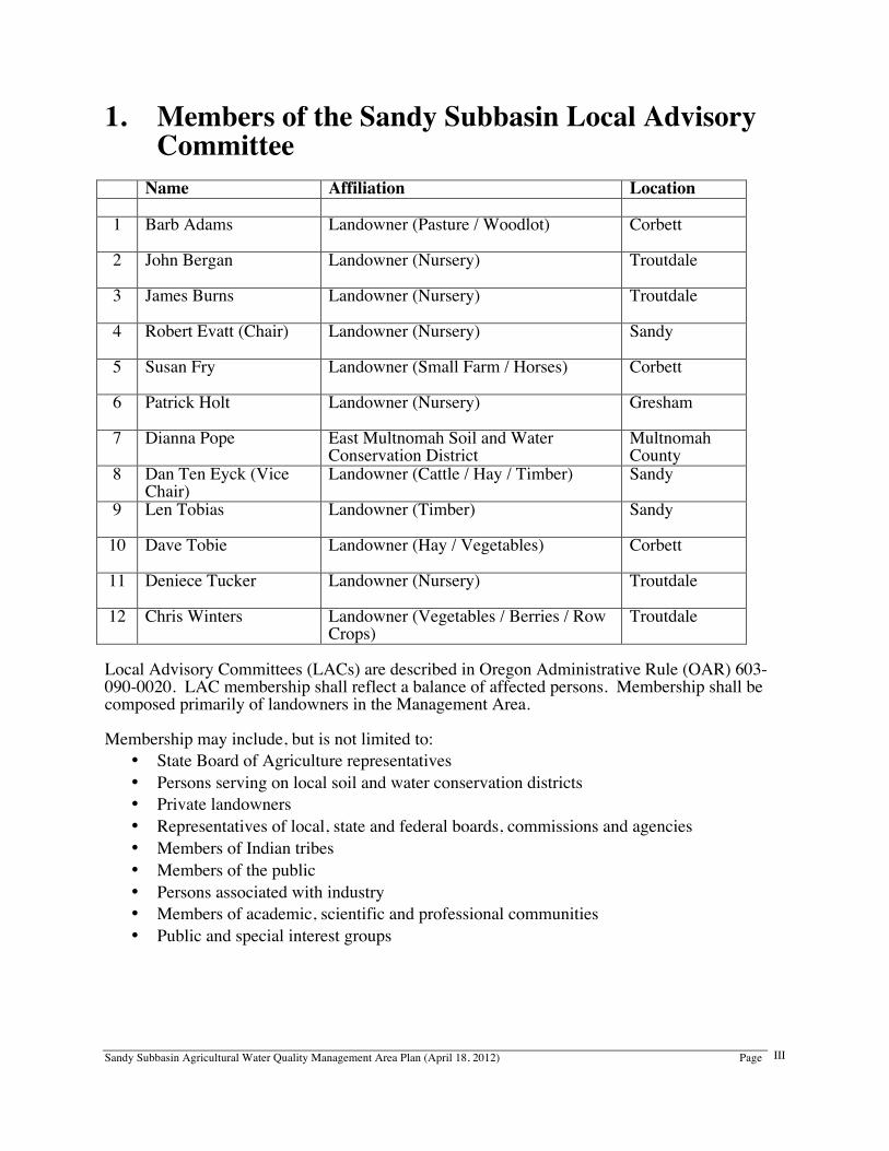
1. Members of the Sandy Subbasin Local Advisory Committee
Name Affiliation Location 1 Barb Adams
Landowner (Pasture / Woodlot) Corbett
2 John Bergan
Landowner (Nursery) Troutdale
3 James Burns
Landowner (Nursery) Troutdale
4 Robert Evatt (Chair)
Landowner (Nursery) Sandy
5 Susan Fry
Landowner (Small Farm / Horses) Corbett
6 Patrick Holt
Landowner (Nursery) Gresham
7 Dianna Pope East Multnomah Soil and Water Conservation District
Multnomah County
8 Dan Ten Eyck (Vice Chair)
Landowner (Cattle / Hay / Timber) Sandy
9 Len Tobias
Landowner (Timber) Sandy
10 Dave Tobie
Landowner (Hay / Vegetables) Corbett
11 Deniece Tucker
Landowner (Nursery) Troutdale
12 Chris Winters Landowner (Vegetables / Berries / Row Crops)
Troutdale
Local Advisory Committees (LACs) are described in Oregon Administrative Rule (OAR) 603-090-0020. LAC membership shall reflect a balance of affected persons. Membership shall be composed primarily of landowners in the Management Area. Membership may include, but is not limited to:
• State Board of Agriculture representatives • Persons serving on local soil and water conservation districts • Private landowners • Representatives of local, state and federal boards, commissions and agencies • Members of Indian tribes • Members of the public • Persons associated with industry • Members of academic, scientific and professional communities • Public and special interest groups

Sandy Subbasin Agricultural Water Quality Management Area Plan (April 18, 2012) Page
IV
Blank
Sandy Subbasin Agricultural Water Quality Management Area Plan (April 18, 2012) Page
V
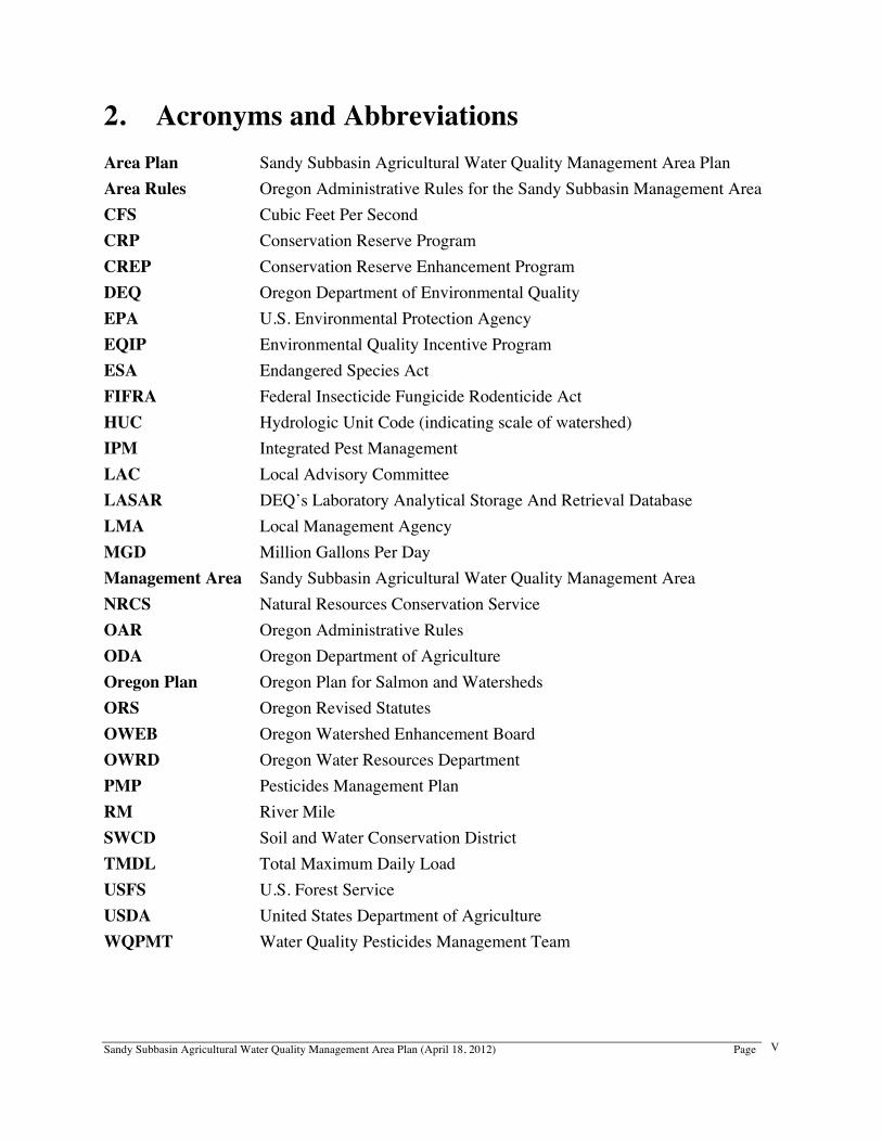
2. Acronyms and Abbreviations Area Plan Sandy Subbasin Agricultural Water Quality Management Area Plan Area Rules Oregon Administrative Rules for the Sandy Subbasin Management Area CFS Cubic Feet Per Second CRP Conservation Reserve Program CREP Conservation Reserve Enhancement Program DEQ Oregon Department of Environmental Quality EPA U.S. Environmental Protection Agency EQIP Environmental Quality Incentive Program ESA Endangered Species Act FIFRA Federal Insecticide Fungicide Rodenticide Act HUC Hydrologic Unit Code (indicating scale of watershed) IPM Integrated Pest Management LAC Local Advisory Committee LASAR DEQ’s Laboratory Analytical Storage And Retrieval Database LMA Local Management Agency MGD Million Gallons Per Day Management Area Sandy Subbasin Agricultural Water Quality Management Area NRCS Natural Resources Conservation Service OAR Oregon Administrative Rules ODA Oregon Department of Agriculture Oregon Plan Oregon Plan for Salmon and Watersheds ORS Oregon Revised Statutes OWEB Oregon Watershed Enhancement Board OWRD Oregon Water Resources Department PMP Pesticides Management Plan RM River Mile SWCD Soil and Water Conservation District TMDL Total Maximum Daily Load USFS U.S. Forest Service USDA United States Department of Agriculture WQPMT Water Quality Pesticides Management Team

Sandy Subbasin Agricultural Water Quality Management Area Plan (April 18, 2012) Page
VI
Blank
Sandy Subbasin Agricultural Water Quality Management Area Plan (April 18, 2012) Page
1
3. Foreword This Agricultural Water Quality Management Area Plan (Area Plan) provides guidance for addressing agricultural water quality issues in the Sandy Subbasin Agricultural Water Quality Management Area (Management Area). The purpose of this Area Plan is to identify strategies to prevent and control water pollution from agricultural activities and soil erosion on agricultural and rural lands ((Oregon Revised Statutes (ORS) 568.909(2)), and to meet applicable water quality standards ((ORS 561.191(2)). The Area Plan is implemented using a combination of outreach and education, management activities, monitoring, evaluation, and enforcement. According to OAR 603-090-0030(1), Agricultural Water Quality Management Area Plans must describe a program to achieve the water quality goals and standards necessary to protect designated beneficial uses related to water quality, as required by state and federal law. An Area Plan shall include but not be limited to:
• a description of the geographical area and physical setting to which the Area Plan applies
• a listing of water quality issues of concern • a listing of current designated beneficial uses that are being adversely affected • a statement that the goal of the Area Plan is to prevent and control water pollution
from agricultural activities and soil erosion and to achieve applicable water quality standards
• a statement of the water quality objectives of the Area Plan • a description of the pollution prevention and control measures deemed necessary by
ODA to achieve the goal • a schedule for implementation of the necessary measures that is adequate to meet
applicable dates established by law • guidelines for public participation • a strategy for ensuring that the necessary measures are implemented
The provisions of this Area Plan do not establish legal requirements or prohibitions, as described in ORS 568.912(1). The Oregon Department of Agriculture (ODA) will exercise its enforcement authority for the prevention and control of water pollution from agricultural activities and soil erosion on agricultural and rural lands under OAR 603-095-1300 through 603-095-1380 (the administrative rules for the Sandy Subbasin Management Area) and OAR 603-090-0000 through 603-090-0120 (the administrative rules for the Agricultural Water Quality Program).
Sandy Subbasin Agricultural Water Quality Management Area Plan (April 18, 2012) Page
2
4. Introduction This document is the Sandy Subbasin Agricultural Water Quality Management Area Plan (Area Plan) for the enhancement of water quality and the prevention and control of factors adversely affecting water quality from agricultural activities and rural lands in the Management Area. The Sandy Subbasin Area Plan was created through the joint efforts of a LAC) consisting predominantly of affected landowners residing within the Management Area, ODA, and the Clackamas County and East Multnomah Soil and Water Conservation Districts (SWCD). This Area Plan applies to all land currently in agricultural use, regardless of size, within the Management Area. For example, the Area Plan applies equally to large commercial production lands and to small rural land grazing a few animals. It also applies to all agricultural lands which lay idle or on which management has been deferred. However, non-agricultural and urban lands, and land subject to the Forest Practices Act, that are not involved in agricultural activities, are not subject to this Area Plan, except where soil erosion occurs on rural lands. Different portions of a single property may be subject to this Area Plan, and/or the Oregon Forest Practices Act (ORS 527.610 through 527.992; OAR 629-600 through 629-680), and/or other laws, rules, or programs related to water quality or soil erosion. The 1993 Oregon Legislature passed the Agricultural Water Quality Management Act (Senate Bill 1010), authorizing ODA as the lead state agency working with agriculture to address nonpoint source water pollution. The Act is codified in ORS 568.900 through 568.933. Under the law, ODA is authorized to develop and carry out a water quality management plan for any agricultural or rural lands where a Water Quality Management Plan is required by state or federal law. This Area Plan has been developed and subsequently revised pursuant to the Agricultural Water Quality Management Act. In 1995, the Oregon Legislature passed legislation (SB 502), now codified in ORS 561.191, which states that ODA shall develop and implement any program or rules that directly regulate farming practices for the purpose of protecting water quality and that are applicable to areas of the state designated as exclusive farm use zones or other agricultural lands. Under these statutes, ODA is the agency responsible for regulating agricultural activities in Oregon as they affect water quality. In 1997, Oregonians began implementing the Oregon Plan for Salmon and Watersheds (Oregon Plan; www.oregon.gov/OPSW). The Oregon Plan’s mission is to restore our native fish populations and the aquatic systems that support them to productive and sustainable levels that will provide substantial environmental, cultural, and economic benefits. ODA’s commitment to the Oregon Plan was to design and implement Agricultural Water Quality Management Area Plans in areas throughout the state of Oregon by the end of 2002. The Oregon Agricultural Water Quality Management Program fulfills agriculture’s role in the joint effort by all land uses - urban, rural-residential, industry, forestry, and agriculture - for cleaner water as envisioned in the Oregon Plan. ODA has the legal authority to prevent and control water pollution from agricultural activities and soil erosion on agricultural and rural lands in the Sandy Subbasin Management Area. In turn, through a Memorandum of Agreement, ODA designated East Multnomah SWCD and Clackamas County SWCD and as its Local Management Agencies (LMAs) for implementation of the Oregon Agricultural Water Quality Program in the Management Area. East Multnomah SWCD also has administrative responsibilities related to biennial review of the Area Plan and Rules. These responsibilities were previously fulfilled by Clackamas County SWCD.
Sandy Subbasin Agricultural Water Quality Management Area Plan (April 18, 2012) Page
3
SWCDs have a long standing record of effectively identifying conservation concerns, developing action plans to address problems, and facilitating assistance to agricultural operators who voluntarily participate in conservation programs. SWCDs work cooperatively with the United States Department of Agriculture (USDA), USDA Natural Resource Conservation Service (NRCS), the USDA Farm Service Agency, and the Oregon State University Extension Service. These agencies provide technical, financial, and educational assistance to individual agricultural operators for the installation and maintenance of conservation practices and pollution control and prevention measures. SWCDs also play an important role in the development of partnerships between local agencies, volunteer organizations, and private landowners to address natural resource and conservation issues. The Sandy Subbasin LAC was formed in January 1999 to assist with the development of this Area Plan, and to recommend strategies to achieve the water quality goals and objectives of the Area Plan. The LAC is comprised predominantly of agricultural producers who live within the Management Area. LAC members are involved in a wide variety of operations including row crops, nursery, livestock, grain, vegetables, hay, timber, and berries. The East Multnomah SWCD and small acreage interests are also represented on the LAC. Recreational and environmental interests have also been represented on the LAC in the past.
Sandy Subbasin Agricultural Water Quality Management Area Plan (April 18, 2012) Page
4
5. Strategy for Public Participation This Area Plan was developed by the Sandy Subbasin LAC, ODA, and the LMAs, and was presented to the State Board of Agriculture for their review and consultation. With the State Board of Agriculture’s concurrence, the draft Plan and the associated Rules were presented to the public through two informational meetings and one formal public hearing within the agricultural and rural portions of the Management Area. ODA reviewed testimony presented at public hearings and during the public comment period. With assistance from the LAC, ODA modified the Area Plan and Area Rules as appropriate to address those issues. Recommended modifications were presented to the Board of Agriculture and the director of the ODA for their review. Final acceptance and adoption of the Area Plan and Area Rules resulting from this review is the responsibility of the director of the ODA in consultation with the State Board of Agriculture. The LAC, ODA, and the LMAs conduct biennial reviews of the Area Plan and Area Rules. Interested partners and stakeholders, along with the public, are invited to participate in the biennial review process.
Sandy Subbasin Agricultural Water Quality Management Area Plan (April 18, 2012) Page
5
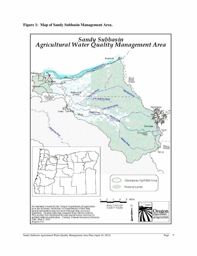
6. Background A. Geographical and Physical Setting The Sandy Subbasin is in northwest Oregon, with the southern three-fourths located in Clackamas County and the northern one-fourth located in Multnomah County (Figure 1). The Subbasin drains approximately 582 square miles (373,400 acres), which flows into the Columbia River in the Troutdale area, east of Portland. The Sandy River and its tributaries drain 508 square miles (325,000 acres). The remaining area represents smaller streams that flow directly into the Columbia River in the Columbia River Gorge. These creeks include Tanner, Moffett, McCord, Horsetail, Oneonta, Multnomah, Coopey, Bridal Veil, Young, and Latourell. The Sandy Subbasin Management Area is a 4th field watershed with Hydrologic Unit Code (HUC) number 17080001. Elevation in the Sandy Subbasin ranges from 11,235 feet on the upper slopes of Mt. Hood to approximately 20 feet at the confluence of the Sandy and Columbia rivers. The Sandy River originates from Reid Glacier at approximately 6,200 feet above sea level. Annual rainfall ranges from 40 inches in the Troutdale area to 170 inches at some of the higher elevations in the Cascades. Annual snowfall is about 278 inches in the higher elevations. The ratio for snowfall is ten inches of snow per one-inch of rain (Taylor, 1999). Heaviest precipitation occurs between November and January in the Subbasin. The predominant land use in the Management Area is forest (Table 1). The forested areas are generally in the eastern part of the Management Area, in the foothills and upper elevations of the Cascade Range. Commercial forest is under public and private ownership. Public lands include the Mt. Hood National Forest (68 percent of the Management Area) and Bureau of Land Management land (three percent of the Management Area). The U.S. Forest Service manages the national forest to restore and maintain ecosystem health and aquatic habitats while working with communities to provide opportunities for employment and economic growth through timber sales. Stewardship contracts are special timber sales where a portion of the revenues directly support stream and forest land restoration. Another 24 percent of the Management Area is in private, non-agricultural forest use. Private forest ownership is industrial, nonindustrial, and smaller woodlots. Private landowners manage their forests and woodlands for timber production, along with other diverse values, which may include forest health, fish and wildlife habitat, soil and water quality, and recreation. Water quality impacts on non-federal forests are regulated under the Oregon Forest Practices Act. The westernmost portion of the Management Area is predominantly agricultural, with the urban areas quickly expanding. By the year 2017, the population of the city of Sandy is expected to reach 12,652, a 146 percent increase from the 1998 population of 5,135. By 2017, Troutdale’s population is predicted to reach 15,625, an 11 percent increase from the 1998 population of 14,040 (Yee, 1998). The area known as the Mt. Hood Corridor, consisting of communities along Highway 26 from Brightwood up to Government Camp, was estimated in 1998 to have approximately 6,500 residents, with 58 percent being seasonal residents.
Sandy Subbasin Agricultural Water Quality Management Area Plan (April 18, 2012) Page
6
Figure 1: Map of Sandy Subbasin Management Area.
Sandy Subbasin Agricultural Water Quality Management Area Plan (April 18, 2012) Page
7
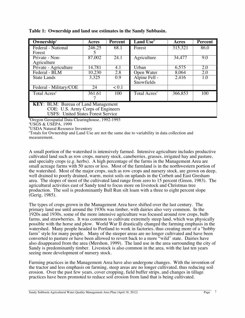
Table 1: Ownership and land use estimates in the Sandy Subbasin.
Ownershipa Acres Percent Land Useb Acres Percent Federal - National Forest
246,255
68.1 Forest 315,321 86.0
Private - Non-Agriculture
87,002 24.1 Agriculture 34,477 9.0
Private - Agriculture 14,781 4.1 Urban 6,575 2.0 Federal - BLM 10,230 2.8 Open Water 8,064 2.0 State Lands 3,325 0.9 Alpine Fell -
Snowfields 2,416 1.0
Federal - Military/COE 24 < 0.1 Total Acresc 361,61
7 100 Total Acresc 366,853 100
KEY: BLM: Bureau of Land Management COE: U.S. Army Corps of Engineers USFS: United States Forest Service
aOregon Geospatial Data Clearinghouse, 1992-1993 aUSGS & USEPA, 1999 bUSDA Natural Resource Inventory cTotals for Ownership and Land Use are not the same due to variability in data collection and measurement. A small portion of the watershed is intensively farmed. Intensive agriculture includes productive cultivated land such as row crops, nursery stock, caneberries, grasses, irrigated hay and pasture, and specialty crops (e.g. herbs). A high percentage of the farms in the Management Area are small acreage farms with 50 acres or less. Most of the farmland is in the northwestern portion of the watershed. Most of the major crops, such as row crops and nursery stock, are grown on deep, well drained to poorly drained, warm, moist soils on uplands in the Corbett and East Gresham area. The slopes of most of the cultivated land range from zero to 15 percent (Green, 1983). The agricultural activities east of Sandy tend to focus more on livestock and Christmas tree production. The soil is predominantly Bull Run silt loam with a three to eight percent slope (Gerig, 1985). The types of crops grown in the Management Area have shifted over the last century. The primary land use until around the 1930s was timber, with dairies also very common. In the 1920s and 1930s, some of the more intensive agriculture was focused around row crops, bulb farms, and strawberries. It was common to cultivate extremely steep land, which was physically possible with the horse and plow. World War II drastically changed the farming emphasis in the watershed. Many people headed to Portland to work in factories, thus creating more of a “hobby farm” style for many people. Many of the steeper areas are no longer cultivated and have been converted to pasture or have been allowed to revert back to a more “wild” state. Dairies have also disappeared from the area (Mershon, 1999). The land use in the area surrounding the city of Sandy is predominantly timber. Livestock is also common in the area, with the last ten years seeing more development of nursery stock. Farming practices in the Management Area have also undergone changes. With the invention of the tractor and less emphasis on farming, steep areas are no longer cultivated, thus reducing soil erosion. Over the past few years, cover cropping, field buffer strips, and changes in tillage practices have been promoted to reduce soil erosion from land that is being cultivated.
Sandy Subbasin Agricultural Water Quality Management Area Plan (April 18, 2012) Page
8
Improvements in farming equipment have allowed for fewer trips over a field, resulting in decreased soil compaction. Sub-soiling has also helped to reduce runoff and compaction. B. Water Resources Water in the Management Area is appropriated and diverted for municipal, fish, industrial, and irrigation use. The primary use for which water rights are issued in the Subbasin is municipal. The largest designation is to the city of Portland for municipal applications. All other uses in the basin have been appropriated for a combined amount of 173 cfs (cubic feet per second). Of that, 26 cfs are allocated for agriculture in the Subbasin. There is an estimated 3,000 acres of irrigated land in the Subbasin with no expected increase in the amount of irrigated land in the next 20 years (Oregon Water Resources Department, 1991). The city of Portland holds a statutory right to the water in the Bull Run and Little Sandy rivers. In an average weather year, the Portland Water Bureau estimates that peak season (122 days) daily average water demand is about 123 million gallons per day (MGD). Future projected demand from the system is contingent on a number of variables, including population growth, service area, long-term climate change, and conservation assumptions. The current projections for average daily peak season demand (from the Bull Run system and the Columbia South Shore Well Field) in the year 2028 is 133 MGD (Portland Water Bureau, 2010). This would be about 25 percent utilization of the Bull Run River’s annual discharge. To supply this water, two dams have been built on the Bull Run River thus creating two reservoirs. The city of Portland is not currently utilizing its right to the waters of the Little Sandy River. Stream flow in the Sandy River watershed varies throughout the year, with high and low flows having different impacts on the landscape and resources. Stream flows vary widely between summer and winter. Upon reaching the Columbia River, the Sandy River discharges a mean peak rate of 3,899 cfs in January. The mean low occurs in August with 539 cfs being discharged (OWRD, 1991). During the winter high stream flows, a prominent resource concern is soil erosion. During periods of low stream flow, nutrients can more negatively impact water quality because of their greater concentration than in periods of higher stream flow. Higher stream temperatures associated with low flow in the summertime are a major factor affecting aquatic life. Several glaciers feed the Sandy River, acting as reservoirs. During the summer, the glacial reservoirs release cool flows helping to maintain cool stream temperatures and regulate summer flows. Due to heavy precipitation in the winter, slope instability or landslides contribute to some of the sediment production in the area (Sandy River Basin Watershed Council, 1999). Glacial till also contributes to sediment production in the watershed during the summer glacial melting season. The Troutdale Formation is the main groundwater aquifer in the Sandy Subbasin. The Troutdale Formation aquifer has permits issued for its use equaling about 17,000 acre-feet of groundwater per year. Municipal needs account for 71 percent and agriculture for 28 percent. The remaining one percent is for industrial and recreation uses. The Troutdale Formation aquifer can supply from 100 to 500 gallons per minute (OWRD, 1991). Groundwater reduction in the Troutdale Formation aquifer near Sandy has become a concern. A major problem in the Management Area is groundwater contamination from human activities. Improper sewage and industrial waste disposal have caused problems with groundwater contamination. The increasing number of
Sandy Subbasin Agricultural Water Quality Management Area Plan (April 18, 2012) Page
9
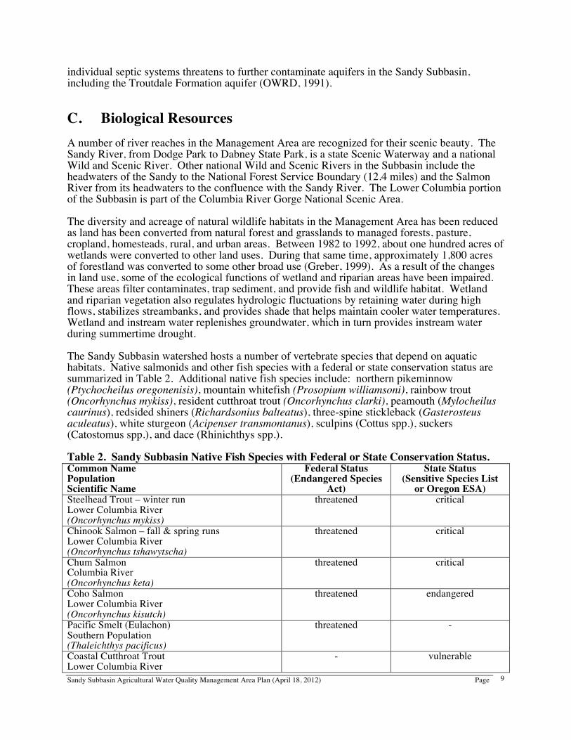
individual septic systems threatens to further contaminate aquifers in the Sandy Subbasin, including the Troutdale Formation aquifer (OWRD, 1991). C. Biological Resources A number of river reaches in the Management Area are recognized for their scenic beauty. The Sandy River, from Dodge Park to Dabney State Park, is a state Scenic Waterway and a national Wild and Scenic River. Other national Wild and Scenic Rivers in the Subbasin include the headwaters of the Sandy to the National Forest Service Boundary (12.4 miles) and the Salmon River from its headwaters to the confluence with the Sandy River. The Lower Columbia portion of the Subbasin is part of the Columbia River Gorge National Scenic Area. The diversity and acreage of natural wildlife habitats in the Management Area has been reduced as land has been converted from natural forest and grasslands to managed forests, pasture, cropland, homesteads, rural, and urban areas. Between 1982 to 1992, about one hundred acres of wetlands were converted to other land uses. During that same time, approximately 1,800 acres of forestland was converted to some other broad use (Greber, 1999). As a result of the changes in land use, some of the ecological functions of wetland and riparian areas have been impaired. These areas filter contaminates, trap sediment, and provide fish and wildlife habitat. Wetland and riparian vegetation also regulates hydrologic fluctuations by retaining water during high flows, stabilizes streambanks, and provides shade that helps maintain cooler water temperatures. Wetland and instream water replenishes groundwater, which in turn provides instream water during summertime drought. The Sandy Subbasin watershed hosts a number of vertebrate species that depend on aquatic habitats. Native salmonids and other fish species with a federal or state conservation status are summarized in Table 2. Additional native fish species include: northern pikeminnow (Ptychocheilus oregonenisis), mountain whitefish (Prosopium williamsoni), rainbow trout (Oncorhynchus mykiss), resident cutthroat trout (Oncorhynchus clarki), peamouth (Mylocheilus caurinus), redsided shiners (Richardsonius balteatus), three-spine stickleback (Gasterosteus aculeatus), white sturgeon (Acipenser transmontanus), sculpins (Cottus spp.), suckers (Catostomus spp.), and dace (Rhinichthys spp.). Table 2. Sandy Subbasin Native Fish Species with Federal or State Conservation Status. Common Name Population Scientific Name
Federal Status (Endangered Species
Act)
State Status (Sensitive Species List
or Oregon ESA) Steelhead Trout – winter run Lower Columbia River (Oncorhynchus mykiss)
threatened critical
Chinook Salmon – fall & spring runs Lower Columbia River (Oncorhynchus tshawytscha)
threatened critical
Chum Salmon Columbia River (Oncorhynchus keta)
threatened critical
Coho Salmon Lower Columbia River (Oncorhynchus kisutch)
threatened endangered
Pacific Smelt (Eulachon) Southern Population (Thaleichthys pacificus)
threatened -
Coastal Cutthroat Trout Lower Columbia River
- vulnerable
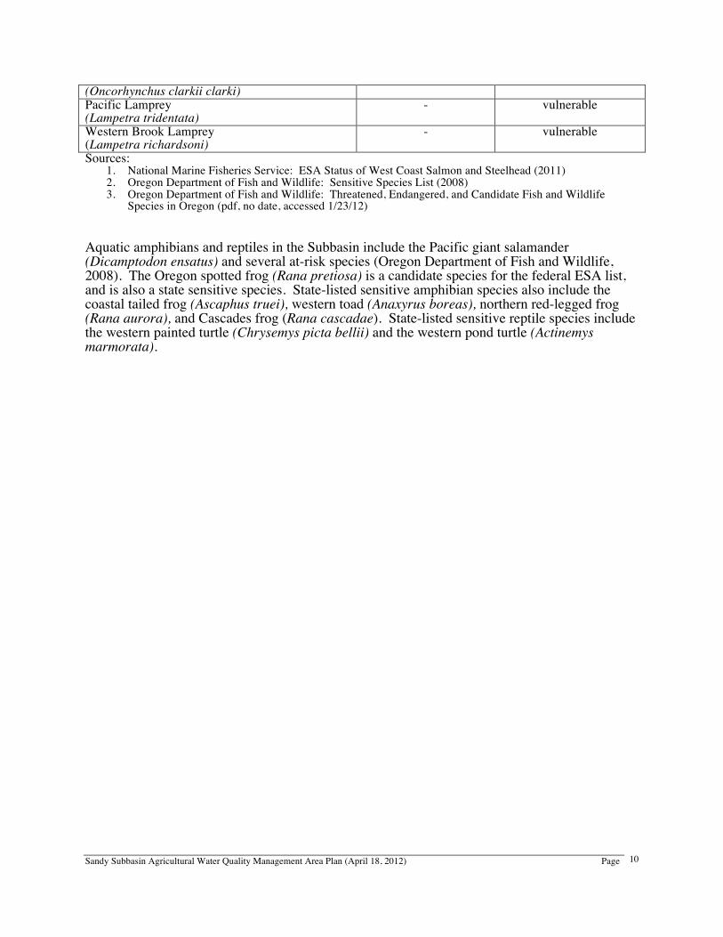
Sandy Subbasin Agricultural Water Quality Management Area Plan (April 18, 2012) Page
10
(Oncorhynchus clarkii clarki) Pacific Lamprey (Lampetra tridentata)
- vulnerable
Western Brook Lamprey (Lampetra richardsoni)
- vulnerable
Sources: 1. National Marine Fisheries Service: ESA Status of West Coast Salmon and Steelhead (2011) 2. Oregon Department of Fish and Wildlife: Sensitive Species List (2008) 3. Oregon Department of Fish and Wildlife: Threatened, Endangered, and Candidate Fish and Wildlife
Species in Oregon (pdf, no date, accessed 1/23/12) Aquatic amphibians and reptiles in the Subbasin include the Pacific giant salamander (Dicamptodon ensatus) and several at-risk species (Oregon Department of Fish and Wildlife, 2008). The Oregon spotted frog (Rana pretiosa) is a candidate species for the federal ESA list, and is also a state sensitive species. State-listed sensitive amphibian species also include the coastal tailed frog (Ascaphus truei), western toad (Anaxyrus boreas), northern red-legged frog (Rana aurora), and Cascades frog (Rana cascadae). State-listed sensitive reptile species include the western painted turtle (Chrysemys picta bellii) and the western pond turtle (Actinemys marmorata).
Sandy Subbasin Agricultural Water Quality Management Area Plan (April 18, 2012) Page
11
7. Water Quality Issues A. Sources of Water Pollution There are two main types of water pollution. Point source pollution emanates from clearly identifiable discharge points such as wastewater treatment plants. Nonpoint source pollution originates from the general landscape and is difficult to trace to a single point. Pollutants from nonpoint sources are carried to the surface water or groundwater through the action of rainfall, irrigation runoff, and seepage. Nonpoint sources of pollution in the Management Area include erosion (from development in urban / suburban / urbanizing areas, agricultural and forest lands, streambanks, and roadside ditches) and contaminated runoff (from livestock and other agricultural operations, urban areas, septic systems, and natural sources). Two wastewater treatment plants discharge directly into the Sandy River. The city of Troutdale discharges 1.6 MGD into the Sandy River and the Hoodland Wastewater Treatment Plant, serving Welches and Rhododendron, and discharges about 300,000 gallons a day into the Sandy River. The Government Camp Sanitary District discharges 90,000 gallons a day into Camp Creek, a tributary of the Sandy River. Discharge levels are strongly influenced by weather conditions. Sites and facilities holding stormwater and industrial wastewater permits also discharge to surface water in the Sandy Subbasin, and several facilities hold permits to discharge wastewater to land application or subsurface systems. B. Parameters of Concern Temperature measurements show that approximately 55 river miles of the Sandy River and its tributary streams do not meet state temperature criteria to protect fish health. The beneficial uses (see Definitions) affected by temperature are resident fish and aquatic life, core cold water habitat, and salmonid, steelhead, and trout spawning, rearing and migration. The prevention and control measure (Area Rules; OAR 603-095-1340) associated with temperature is Streamside Area Condition. Data from the Oregon Department of Environmental Quality (DEQ) also show that four stream segments – Beaver Creek from the mouth to River Mile (RM) 8.3, Cedar Creek from the mouth to RM 4.3, Kelly Creek from the mouth to RM 4.8, and an unnamed stream from RM 0 to 2.9 – do not meet the state bacteria (E. coli) criteria. The beneficial use affected by E. coli is water contact recreation. The prevention and control measures (Area Rules; OAR 603-095-1340) associated with the E. coli parameter are Agricultural Waste Control and Streamside Area Condition. DEQ most recently identified impaired stream reaches, including those in the Sandy Subbasin, in the 2010 Integrated Report to the U.S. Environmental Protection Agency (EPA). See Appendix A for a complete list of streams that do not meet temperature or bacteria standards in the Sandy Subbasin. Information regarding additional water quality concerns can be found on the DEQ website at: www.deq.state.or.us/wq/assessment/assessment.htm. Many of the pollution sources cited here and in the Geographical and Physical Setting affect water quality but are beyond the scope and influence of agricultural landowners/operators. Under the prevention and control measures in the Sandy Subbasin Management Area Rules (OAR 603-095-1340), landowners and operators are not responsible for mitigating or dealing with factors that do not result from agricultural practices. These factors include but are not limited to:
Sandy Subbasin Agricultural Water Quality Management Area Plan (April 18, 2012) Page
12
• Glacial till from glacial runoff, natural sediment transport, and landslides • Septic systems and public sewage disposal • Public roadways or rights of way or easements next to streams, rivers, or other bodies of
water • Public culverts, roadside ditches, drainage, and shoulders • Dams, dam removal, hydroelectric plants, and non-agricultural impoundments • Housing and other development in agricultural land areas • Extreme and/or unforeseen weather events • Any other factor that occurs on public or private lands outside the direct control of the
landowner/operator Surface water quality in the Management Area varies from good to fair. Water quality is quite good during the high flow months. Low flows in the summer reduce fish holding, spawning, and rearing areas, food production, and water quality, especially in regards to temperature. C. Total Maximum Daily Loads DEQ, in accordance with the federal Clean Water Act, is required to establish Total Maximum Daily Loads (TMDLs) for pollutants on the list of impaired water bodies (303(d) list). TMDLs generally apply to an entire basin or subbasin, and not just to an individual water body that was on the 303(d) list. TMDLs specify the daily amount of pollution that a water body can receive and still meet water quality standards. Through the TMDL, nonpoint sources (including agriculture, forestry, and urban) are assigned “load allocations”, while point sources are assigned “waste load allocations” in their permits. The agricultural sector is responsible for reducing agricultural nonpoint water pollution to meet the load allocation assigned to agriculture. Once TMDLs are completed for a basin, the basin’s water bodies are removed from the 303(d) list and are assigned to Category 4A (water quality limited, TMDL approved). In the future, when data show that water quality criteria have been met, water bodies will be assigned to Category 2 (attaining). As part of the process, DEQ identifies the Designated Management Agencies or parties responsible for submitting TMDL implementation plans. An agreement between ODA and DEQ establishes that Agricultural Water Quality Management Area Plans serve as TMDL implementation plans for agricultural nonpoint water pollution. This Area Plan is the implementation plan for the agricultural component of the TMDLs that apply to the Management Area. Biennial reviews of the Area Plan and Area Rules will address any new pollutant load allocations assigned to agriculture in future TMDLs. In response to the 303(d) listings through 2002, DEQ completed a basin-wide temperature and bacteria TMDL for the Sandy River Basin, which was accepted by EPA in 2005 (Oregon Department of Environmental Quality, 2005). The Sandy TMDL can be accessed on the DEQ website (www.deq.state.or.us/wq/tmdls/sandy.htm). Other impairments identified in the Management Area, such as flow and habitat modification, do not require TMDLs. The agricultural load allocations that apply to the Sandy Management Area are:
• temperature: all nonpoint sources collectively, including agriculture, have a shared load allocation of 0.05 degrees C of water temperature (with a surrogate of effective shade)
• bacteria: the agricultural load allocation is a 86 percent reduction compared to average loads in 2005
Sandy Subbasin Agricultural Water Quality Management Area Plan (April 18, 2012) Page
13
D. Effects on Beneficial Uses Good water quality is beneficial for many different uses. Beneficial uses (see Definitions) of water in the Sandy River watershed include fishing, swimming, boating, habitat for fish and wildlife, native species enhancement, domestic, municipal, and industrial water supplies, aesthetics, sport and recreation, and production agriculture. Stream temperature and bacteria affect the most sensitive beneficial uses of water, which are salmonid production and survival and water contact recreation. While there may not be severe impacts on water quality from a single nonpoint source or activity, the combined effects from all sources contribute to the impairment of beneficial uses of the Management Area's water. Most of the beneficial use impairments occur during the summer low flow periods.
Sandy Subbasin Agricultural Water Quality Management Area Plan (April 18, 2012) Page
14
8. Documenting Effectiveness Using Priority Areas A. Why Focus Efforts in a Priority Area? The Oregon Agricultural Water Quality Program relies primarily on voluntary improvements in land conditions for agriculture to fulfill its responsibility to prevent and control water pollution. One way to implement an Area Plan systematically is to focus and measure implementation in relatively small areas within the Management Area. The priority area concept evolved from conversations between ODA, LMAs, LACs, and other stakeholders and partners seeking better ways to implement the Oregon Agricultural Water Quality Program and Area Plans. ODA and program partners believe that strategic, focused, and systematic delivery of outreach and technical assistance will lead to more measurable levels of implementation and allow ODA and the LMAs to make better use of limited resources. While the priority area approach is relatively new for ODA, the LMAs, and the LAC, it is consistent with other agencies’ and organizations’ efforts to work proactively in targeted geographic areas. B. Selecting A Priority Area A priority area is usually a small watershed (6th or 7th field HUC) with agricultural lands. An initial priority area is selected jointly by ODA, the LMAs, the LAC, and other partners based on one or more of the following factors:
• Significant water quality concerns probably associated with agricultural activities • LMA and other partners are already working with landowners in an area • Size of the area matches the LMAs’ capacity to work in a relatively short time frame
During the 2012 biennial review process, ODA, the LMAs, and the LAC discussed the priority area concept, an initial priority area, future priority areas, measurable objectives against which to measure implementation, and timelines for implementation. The initial and future priority areas for the Management Area are described in the Strategies section of this Area Plan. C. Land Condition and Water Quality Once a priority area is selected, land condition measures are identified for which baseline and post-implementation data will be collected and mapped. These land condition measures serve as surrogates for the water quality parameters of concern in the priority area. For example, streamside vegetation is generally used as a surrogate for water temperature, sediment may be used as a surrogate for pesticides and mercury, and livestock access to waterways could be used as a surrogate for bacteria. Water quality monitoring data may also help partners evaluate the effects of changing land conditions on water quality parameters such as temperature, bacteria, nutrients, sediment, and pesticides, to evaluate progress in the priority area and to help identify future priority areas. The Oregon Agricultural Water Quality Program focuses on land conditions, in addition to water quality data, for several reasons:
• landowners can see land conditions and have direct control over land conditions
Sandy Subbasin Agricultural Water Quality Management Area Plan (April 18, 2012) Page
15
• it can be difficult to separate agriculture’s influence on water quality data from other influences, such as bacteria from failing septic systems, wildlife, and recreation
• other factors such as climate change, major storm events, or natural disasters may have long-term impacts on water quality that are beyond agriculture’s control
• it is expensive to monitor water quality at the scale needed to evaluate effectiveness • changes in land conditions, such as streamside vegetation, will take a long time to
translate into water quality improvements
D. Focused Outreach and Technical Assistance After land condition measures are identified and baseline conditions are mapped, the LMAs and other interested partners deliver focused and systematic outreach and technical assistance to landowners in the priority area. Every landowner with potential land condition concerns is contacted with an offer of voluntary assistance. Focused, one-on-one (active) outreach and technical assistance efforts are often more effective in reaching landowners than general (passive) outreach. This focused program delivery will allow ODA, the LMAs, and the LAC to implement the Area Plan systematically by moving focused work from one small watershed to the next over time, eventually reaching the entire Management Area. E. Monitoring and Evaluation ODA, the LMAs, and the LAC will evaluate and document the implementation of the Area Plan by assessing improvement of land conditions in the priority area during each biennial review. Comparisons of baseline and post-implementation land conditions (along with available water quality data) will allow these partners to determine whether the selected land condition measures have improved. These partners and other stakeholders will also be able to evaluate the status and trends of Area Plan implementation more readily than from reports of implementation efforts scattered throughout a Management Area. The priority area process will help ODA, the LMAs, the LAC, and other program partners to evaluate whether implementation of the Agricultural Water Quality Program is achieving the measurable objectives in the Area Plan. F. Stream Temperature and Site-Capable Streamside Vegetation Across Oregon’s 38 Water Quality Management Areas, many LMAs - including the East Multnomah and Clackamas County SWCDs - are focusing their initial priority area implementation on streamside vegetation. There are several reasons for this focus:
• streamside vegetation improves water quality for multiple parameters, including temperature, sediment, bacteria, nutrients, toxics, and pesticides
• streamside vegetation is visible from public roads and on aerial photos, allowing agencies, stakeholders, and the general public to see that agriculture is part of the solution
• landowners can take steps to improve streamside vegetation, with or without assistance from the LMA, watershed councils, or other local partners
• streamside vegetation improves fish and wildlife habitat The Oregon Agricultural Water Quality Program uses the concept of “site-capable streamside vegetation” to describe the vegetation that agricultural streamsides generally need in order to prevent and control water pollution. Site-capable streamside vegetation is the vegetation that can
Sandy Subbasin Agricultural Water Quality Management Area Plan (April 18, 2012) Page
16
be expected to grow at a particular site, given natural site factors (e.g. elevation, soils, climate, wildlife, fire, floods) and historical and current human influences (e.g. channelization, roads, invasive species, land management). Site-capable streamside vegetation can be determined for a specific site based on: streamside vegetation (observed at the site, including type, location, and size), streamside vegetation observed at nearby reference sites, and NRCS soil surveys (which often describe the vegetation in uncultivated areas). Generally, mature, site-capable streamside vegetation is needed to protect and control water quality. However, in some cases, site-capable vegetation may not be needed or desirable. For example:
• mature conifers may shade crops or create undesirable microclimates; mature alders may be an adequate alternative
• mature trees may not be necessary to protect and control water quality; willows or other shrubs may suffice on small streams
Site-capable streamside vegetation provides three functions that help to prevent or control water pollution from agricultural activities:
1. shade that blocks direct solar radiation and moderates stream temperatures 2. bank stability and reduction of streambank erosion 3. filtration of pollutants (e.g. bacteria, nutrients, pesticides, mercury, sediment) from
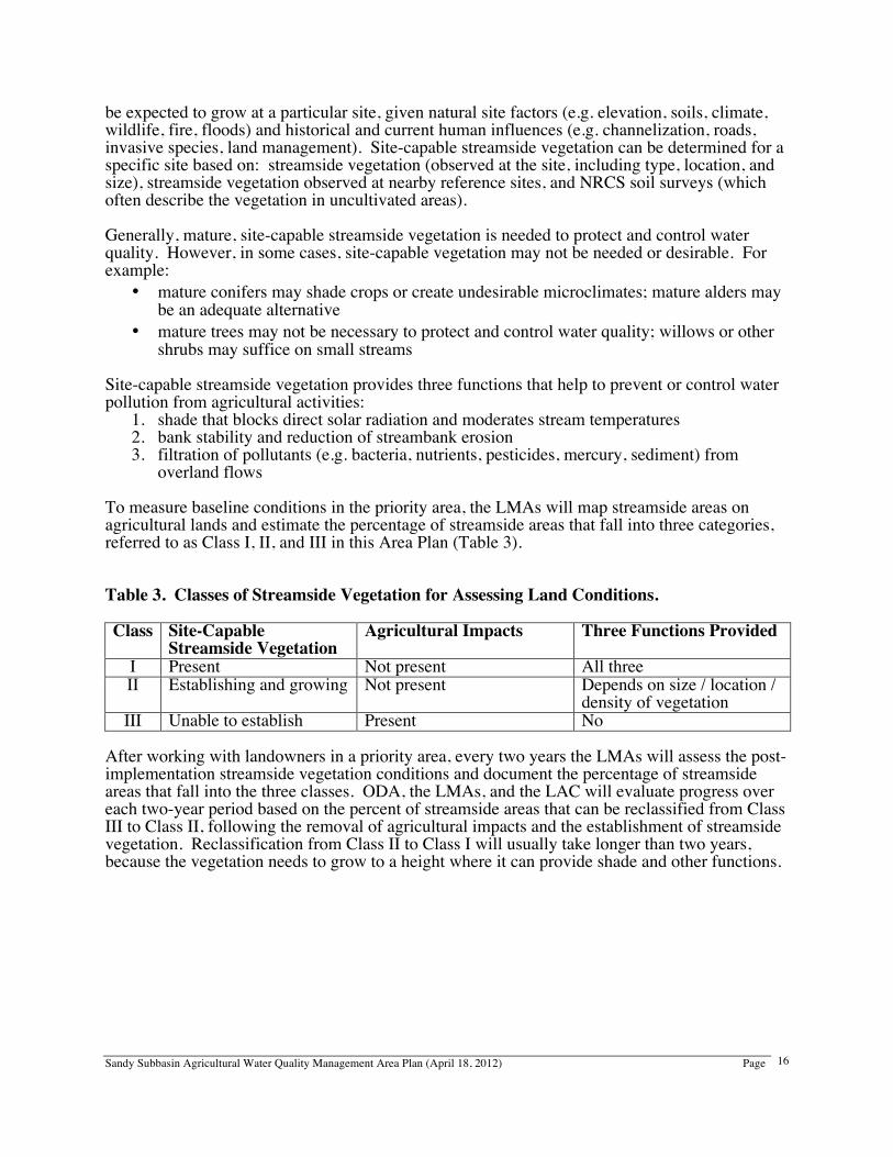
overland flows To measure baseline conditions in the priority area, the LMAs will map streamside areas on agricultural lands and estimate the percentage of streamside areas that fall into three categories, referred to as Class I, II, and III in this Area Plan (Table 3). Table 3. Classes of Streamside Vegetation for Assessing Land Conditions. Class Site-Capable
Streamside Vegetation Agricultural Impacts Three Functions Provided
I Present Not present All three II Establishing and growing Not present Depends on size / location /
density of vegetation III Unable to establish Present No
After working with landowners in a priority area, every two years the LMAs will assess the post-implementation streamside vegetation conditions and document the percentage of streamside areas that fall into the three classes. ODA, the LMAs, and the LAC will evaluate progress over each two-year period based on the percent of streamside areas that can be reclassified from Class III to Class II, following the removal of agricultural impacts and the establishment of streamside vegetation. Reclassification from Class II to Class I will usually take longer than two years, because the vegetation needs to grow to a height where it can provide shade and other functions.
Sandy Subbasin Agricultural Water Quality Management Area Plan (April 18, 2012) Page
17
9. Mission The mission of this Area Plan is to prevent and control water pollution from agricultural activities and soil erosion on agricultural and rural lands, and to achieve applicable water quality standards and agricultural load allocations in the Sandy Subbasin Management Area. This Area Plan will promote sound conservation practices on agricultural and rural lands within a framework of economic profitability and agricultural viability. 10. Goals and Objectives The following goals and objectives are used to achieve the mission of the Area Plan. The continued success of implementing this Area Plan requires the participation of the Clackamas County and East Multnomah SWCDs, the agribusiness community, commodity organizations, partner agencies and organizations, and individual landowners. 1. Prevent and control water pollution from agricultural activities and soil erosion on
agricultural and rural lands to achieve applicable water quality standards.
Objectives • Reduce bacteria from agricultural sources to meet the load allocation for nonpoint sources
in the Sandy River Basin TMDL • Increase site-capable streamside vegetation along agricultural streams to provide effective
shade to meet the nonpoint load allocation in the Sandy River Basin TMDL • Control pollution as close to its source as possible • Promote the restoration, enhancement, and protection of wetland, riparian, and upland areas • Promote the restoration, enhancement, and protection of fish and wildlife habitat
2. Determine the present status of water quality in the Management Area.
Objectives • Assess and evaluate water quality monitoring already conducted by the local partners and
agencies • Establish an ongoing water quality monitoring plan with local partners and agencies • Identify whether additional water quality monitoring is needed • Inventory and assess the watershed condition and sources of pollution • Use present water quality of the Management Area as the baseline to measure changes
3. Achieve conditions on agricultural lands throughout the Management Area that
contribute to good water quality.
Objectives • Ensure that streamside vegetation provides streambank stability, filtration of overland flow,
and moderation of solar heating, consistent with site capability • Eliminate visible sediment loss from cropland through precipitation or irrigation-induced
erosion that may contribute waste to waters of the state • Eliminate significant bare areas (near streams, on pasturelands, and on rangelands) that
may contribute waste to waters of the state
Sandy Subbasin Agricultural Water Quality Management Area Plan (April 18, 2012) Page
18
• Ensure that active gullies (near streams, on pasturelands, and on rangelands) have healed or do not exist where they may contribute waste to waters of the state
• Ensure that livestock manure is stored in a manner and location such that it cannot contribute waste to waters of the state
4. Base actions on sound conservation planning.
Objectives • Identify sound agricultural management strategies which, through widespread adoption,
will lead to achievement of water quality standards and load allocations in the Subbasin • Review and/or conduct ongoing research on the effectiveness of conservation measures • Obtain practical knowledge from agricultural producers and suppliers • Assist any interested person conducting agricultural management or land disturbing
activities to develop and implement a voluntary conservation plan • Provide landowner assistance for project implementation from SWCDs, USDA, NRCS and
other partner organizations 5. Create a high level of awareness and understanding of water quality issues among the
agricultural community and the public through education and technical assistance.
Objectives • Develop and promote demonstration projects that showcase successful conservation
practices and systems • Develop an ongoing media program to inform Subbasin agricultural operators and the
public of conservation issues and events; this includes the distribution of educational material and the submission of public service announcements to area newspapers, radio stations, and newsletters
• Involve the agricultural community and agribusiness in conservation education • Conduct educational programs to promote public awareness of water quality issues and
their solutions from the point of view of the agricultural industry 6. Secure adequate funding for administration and implementation of this Area Plan to
achieve mission, goals, and objectives.
Objectives • Ensure adequate funding for the administration of the Area Plan by the LMA • Obtain ongoing funding for the implementation of sound agricultural management
strategies, conservation planning assistance, conservation education, and water quality monitoring
7. Monitor, evaluate, and document the effectiveness of the Area Plan in improving
streamside conditions and water quality. Long-term Objectives Across the Management Area
• All streamside areas along agricultural lands support site-capable vegetation • Water from agricultural lands meets water quality standards and agricultural load
allocations • Program effectiveness is measured and documented across the Management Area and
across each priority area
Sandy Subbasin Agricultural Water Quality Management Area Plan (April 18, 2012) Page
19
• Voluntary participation is maximized, with enforcement of the Area Rules if needed Short-term Objectives Across the Management Area
• By the 2014 biennial review, an assessment of streamside vegetation conditions along agricultural lands in the entire Management Area will be complete. This assessment will be used to help identify a series of priority areas to focus program implementation and as a baseline for tracking and reporting streamside vegetation improvements over time
• By the 2020 biennial review, across the entire Management Area, all land where agricultural activities prevented streamside vegetation from establishing (Class III), and where landowners accept voluntary assistance, allows site-capable vegetation to establish (Class II)
• By the 2020 biennial review, 25 percent of streamside areas along agricultural lands, where the baseline condition in 2012 showed streamside vegetation not at site capability but allowed to establish (Class II), will have reached site capability (Class I)
Short-term Objectives for the Priority Areas
• By June 30, 2012, priority areas will be identified within the Management Area, where focused voluntary outreach and technical assistance will be delivered systematically for successive two-year periods
• By the 2014 biennial review, all land in the first priority area, where agricultural activities prevent streamside vegetation from establishing (Class III), and where landowners accept voluntary assistance, allows site-capable streamside vegetation to establish (Class II). Land conditions are documented across the entire priority area for pre-and post-implementation.
• By the 2016 and 2018 biennial reviews, the objective described for the first priority area has been completed for the second and third priority areas
8. Monitor and evaluate the implementation rate of the Area Plan, and update as needed. Objectives
• Document the location, number, stream length, and acreage of projects that improve water quality – within the priority area and across the Management Area
• Document the numbers and acreage of operations with approved conservation plans • Evaluate the effectiveness of outreach and education programs designed to provide public
awareness and understanding of water quality issues - for the priority area across the Management Area
• Evaluate the effectiveness of technical and financial resources available to the agricultural community – for the priority area and across the Management Area
• Document prohibited conditions (defined below) and subsequent corrections
Sandy Subbasin Agricultural Water Quality Management Area Plan (April 18, 2012) Page
20
11. Strategies To Achieve Goals and Objectives A. Voluntary Approach To the greatest degree possible, prevention and control of agricultural water pollution will be encouraged in a cooperative spirit through the voluntary efforts of landowners, aided by information and technical and financial assistance from local, state, and federal agencies, and other partner organizations. Education and measuring progress are the keys to the success of this Area Plan. The two LMAs, (Clackamas County SWCD and East Multnomah SWCD), NRCS, Oregon State University, Sandy River Basin Watershed Council, city of Portland, and other groups and agencies will work together to provide agricultural landowners in the Management Area with information about the goals and objectives of the Area Plan, and requirements of the Area Rules. The following strategies will be employed at the local level by the LMAs in cooperation with landowners, other agencies, and other organizations. 1. Work to improve water quality in the Management Area through planning and
implementation of technically sound and economically feasible conservation practices that contribute to meeting Area Plan objectives
2. Create a high level of awareness and an understanding of water quality issues among the
agricultural community and rural public, in a manner that minimizes conflict and encourages cooperative efforts, through education and technical assistance
• Incorporate Area Plan implementation as a priority element in the Clackamas County and East Multnomah SWCD Annual Work Plans and Long-Range Plans, with support from partner organizations
• Develop on-the-ground projects in cooperation with partner organizations to solve critical problems identified by landowners and operators
• Showcase successful projects, practices, and systems through appropriate media and newsletters
• Conduct tours of successful projects for landowners and the media • Conduct educational programs to promote public awareness of water quality issues
and their solutions • Proactively offer and provide site evaluations on any agricultural lands within the
Management Area to assess conditions that may affect water quality • Prioritize sub-watersheds within the Management Area for targeting implementation
strategies 3. Show progress in preventing and controlling water pollution from agricultural and rural lands
through periodic monitoring of land conditions and water quality 4. Encourage adequate funding and administration of the program to achieve Area Plan goals
and objectives through: • systematic, long-range planning • focused, coordinated efforts using priority-area-based approaches • identifying needs • developing projects
Sandy Subbasin Agricultural Water Quality Management Area Plan (April 18, 2012) Page
21
• actively seeking funding • ensuring successful implementation of projects
B. Priority Areas: Strategic Implementation of the Area Plan ODA, the LMAs, the LAC, and other partners will identify priority areas within the Management Area. Outreach and technical assistance will be focused in these areas, and every landowner with potential land condition concerns will be contacted with an offer of voluntary assistance. ODA, the LMAs, and the LAC will measure, evaluate, and document the effectiveness of the Area Plan by assessing changes in land conditions in the current priority area during each biennial review of the Area Plan. During each biennial review, the partners will also assess the timeline and sequence for working in the initial priority area and in future priority areas. Strategies for Working in Priority Areas The following steps outline the general process for implementing the Area Plan in a priority area and for documenting effectiveness.
• Identify water quality parameter(s) of concern and possible land condition surrogate (e.g. temperature and streamside vegetation)
• Compile and map available baseline land condition and water quality data • Conduct outreach to promote awareness of water quality issues and their solutions • Conduct systematic one-on-one landowner outreach to assess land conditions and offer
voluntary technical assistance • Secure necessary resources to help landowners achieve land conditions that contribute to
good water quality • Map land conditions after two years of implementation and compare with baseline • Compile updated available water quality data and compare with baseline • Evaluate and discuss program effectiveness at each biennial review of the Area Plan
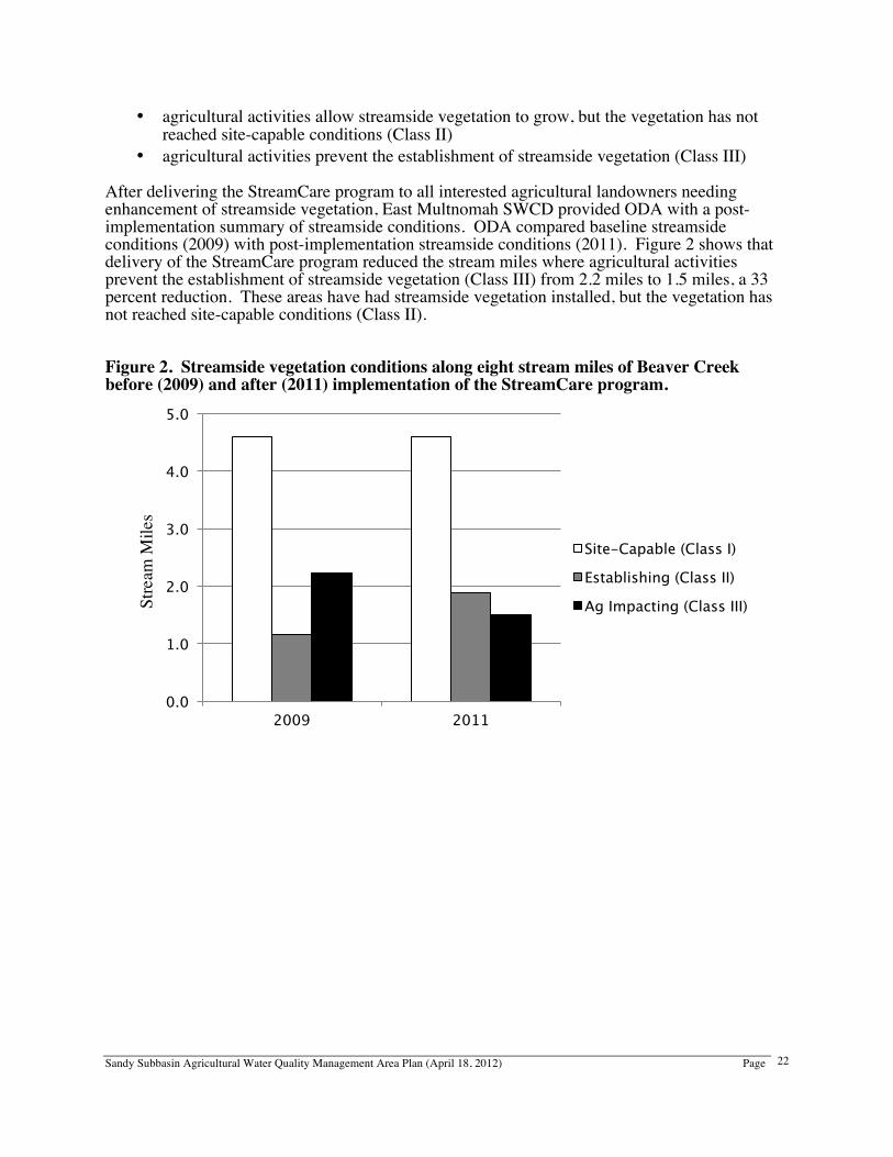
In addition to focusing efforts in a priority area, the LMAs will also identify areas of concern across the Management Area, where agricultural practices are not allowing streamside vegetation to establish. The LMAs will provide one-on-one voluntary technical assistance to landowners to achieve land conditions that contribute to good water quality. Beaver Creek: First Priority Area East Multnomah SWCD identified Beaver Creek and its tributaries as its first priority area, with streamside vegetation as the land condition to monitor and improve. Streamside vegetation enhancement can improve water quality from agricultural lands by providing shade (to lower stream temperatures), reducing streambank erosion (to reduce sediment), and filtering overland flows (to reduce sediment, nutrients, bacteria, pesticides, and more). In Beaver Creek and its tributaries, East Multnomah SWCD has been systematically providing voluntary technical assistance to agricultural and other landowners needing enhancement of streamside vegetation, via their StreamCare program. East Multnomah SWCD delivered the StreamCare program to Beaver, North Fork Beaver, and South Fork Beaver creeks in 2009-2011. ODA estimated streamside conditions on agricultural lands along Beaver Creek, based on 2009 aerial photos. This baseline assessment shows areas where:
• site-capable streamside vegetation is present and providing functions (Class I)
Sandy Subbasin Agricultural Water Quality Management Area Plan (April 18, 2012) Page
22
• agricultural activities allow streamside vegetation to grow, but the vegetation has not reached site-capable conditions (Class II)
• agricultural activities prevent the establishment of streamside vegetation (Class III) After delivering the StreamCare program to all interested agricultural landowners needing enhancement of streamside vegetation, East Multnomah SWCD provided ODA with a post-implementation summary of streamside conditions. ODA compared baseline streamside conditions (2009) with post-implementation streamside conditions (2011). Figure 2 shows that delivery of the StreamCare program reduced the stream miles where agricultural activities prevent the establishment of streamside vegetation (Class III) from 2.2 miles to 1.5 miles, a 33 percent reduction. These areas have had streamside vegetation installed, but the vegetation has not reached site-capable conditions (Class II). Figure 2. Streamside vegetation conditions along eight stream miles of Beaver Creek before (2009) and after (2011) implementation of the StreamCare program.
Stre
am M
iles
0.0
1.0
2.0
3.0
4.0
5.0
2009 2011
Site-Capable (Class I) Establishing (Class II) Ag Impacting (Class III)
Sandy Subbasin Agricultural Water Quality Management Area Plan (April 18, 2012) Page
23
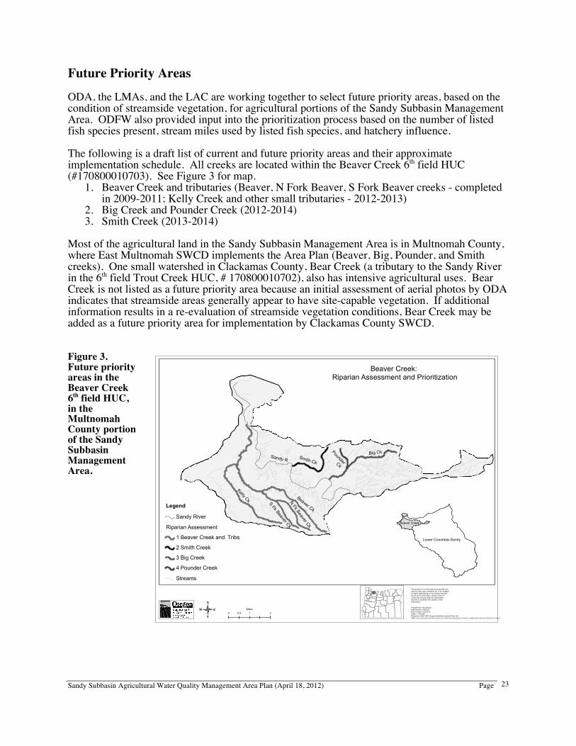
Future Priority Areas ODA, the LMAs, and the LAC are working together to select future priority areas, based on the condition of streamside vegetation, for agricultural portions of the Sandy Subbasin Management Area. ODFW also provided input into the prioritization process based on the number of listed fish species present, stream miles used by listed fish species, and hatchery influence. The following is a draft list of current and future priority areas and their approximate implementation schedule. All creeks are located within the Beaver Creek 6th field HUC (#170800010703). See Figure 3 for map.
1. Beaver Creek and tributaries (Beaver, N Fork Beaver, S Fork Beaver creeks - completed in 2009-2011; Kelly Creek and other small tributaries - 2012-2013)
2. Big Creek and Pounder Creek (2012-2014) 3. Smith Creek (2013-2014)
Most of the agricultural land in the Sandy Subbasin Management Area is in Multnomah County, where East Multnomah SWCD implements the Area Plan (Beaver, Big, Pounder, and Smith creeks). One small watershed in Clackamas County, Bear Creek (a tributary to the Sandy River in the 6th field Trout Creek HUC, # 170800010702), also has intensive agricultural uses. Bear Creek is not listed as a future priority area because an initial assessment of aerial photos by ODA indicates that streamside areas generally appear to have site-capable vegetation. If additional information results in a re-evaluation of streamside vegetation conditions, Bear Creek may be added as a future priority area for implementation by Clackamas County SWCD. Figure 3. Future priority areas in the Beaver Creek 6th field HUC, in the Multnomah County portion of the Sandy Subbasin Management Area.
Big Ck
Beaver Ck
S Fk Beaver Ck
Smith CkSandy R
Pounder Ck
N Fk Beaver Ck
Kelly Ck
0 1 20.5Miles
This product is for informational purposes andmay not have been prepared for, or be suitablefor legal, engineering, or surveying purposes.Users of this information should review or consult the primary data and informationsources to ascertain the usability of theinformation.
Prepared By: Ken DiebelDate Saved: 1/23/2012Date Printed: 1/23/2012Scale: 1:100,000Projection: NAD 1983 Oregon Statewide Lambert Feet IntlPath: X:\NATURALRESOURCES\WATERQUALITY\RIPARIANASSESSMENT\LOWERCOLUMBIASANDY\BEAVERCREEKPRIORITY.MXD-
Legend
Sandy River
Riparian Assessment
1 Beaver Creek and Tribs
2 Smith Creek
3 Big Creek
4 Pounder Creek
Streams
Beaver Creek: Riparian Assessment and Prioritization
Beaver Creek
Lower Columbia-Sandy
Sandy Subbasin Agricultural Water Quality Management Area Plan (April 18, 2012) Page
24
C. Education Area Plan and Area Rules ODA and the LMAs will provide presentations on the Area Plan and Area Rules to interested groups on an ongoing basis. The LMAs will also meet individually with landowners to explain the Area Plan and Area Rules and to provide site-specific reviews of land conditions regarding agricultural water quality. General Education Efforts The LMAs will coordinate the education efforts. The LMAs will work with partner agencies and groups (including Oregon State University Extension Service, USDA NRCS, ODA, Sandy River Basin Watershed Council, Bureau of Land Management, Oregon Water Resources Department, city of Portland, local school agriculture and science programs, and Mt. Hood Community College natural resource classes) to carry out the education strategies outlined in this Area Plan and to encourage the adoption of practices to reduce and control water pollution from agricultural activities. The strategies for carrying out the educational component of the Area Plan may include: 1. Conduct education programs to promote public awareness of water quality issues and their solutions
• Hold workshops on water quality issues and the conservation practices that will help improve water quality and agricultural operation efficiency
• Develop demonstration projects to showcase effective conservation practices and systems in conjunction with local educational institutions
• Organize tours of demonstration projects for agricultural managers and producers • Produce and distribute brochures about water quality issues • Focus educational efforts on small landowners/hobby farmers
2. Develop an ongoing media program to inform agricultural operators and the public of conservation issues and events
• Include updates on the status of the Area Plan and Rules, and water quality data, in the LMA newsletter and in local newspapers/media
• Develop and implement an LMA newsletter to be sent to all agricultural producers in the Management Area, including those who file F-schedule tax forms or are in Exclusive Farm Use zones
• Submit news articles and public service announcements to area newspapers, radio stations, and newsletters
• Invite media to conservation tours and workshops • Create an “advice” column for a local newspaper: for example the “Home and
Gardens” or “Environmental” sections of the Oregonian, the Gresham Outlook, Sandy Post, Sandy Profile, or Capital Press
3. Involve the agricultural and rural community in conservation education
• Create and maintain a list of experienced agricultural operators willing to share their best management practices with other interested people by speaking, leading tours and providing our sites
4. Build partnerships with agriculture businesses to promote conservation
• Co-sponsor workshops and tours with the LMAs
Sandy Subbasin Agricultural Water Quality Management Area Plan (April 18, 2012) Page
25
• Share education materials with agribusiness field representatives, feed stores, and retail agricultural suppliers to target small farm operations
5. Involve educational institutions in conservation, education, and research. For example,
Oregon State University, Mt. Hood Community College, Clackamas Community College, and high school science / agricultural programs are good potential partners. The focus of the educational effort will be:
• Conservation planning • Prevention and control of water pollution, and restoration and enhancement of water
quality, using sound agricultural management strategies • Management of small acreages for water quality protection • Riparian areas – issues and considerations • Water quality conditions
Specific Education Topics The purpose of the education program is to provide landowners with information they can use to address land conditions in their day-to-day activities to prevent and control water pollution and soil erosion from their land. A priority for this education program will be to address water temperature and bacteria concerns in the Sandy Subbasin Management Area, which are on the 2010 303(d) list, by supporting the implementation of strategies such as those listed below under Streamside Conditions and Functions and Agricultural Waste. D. Streamside Conditions and Functions With appropriate information, time, and hard work, landowners can develop flexible streamside vegetation management strategies while providing the following important functions:
• Shade to reduce solar radiation reaching the water • A buffer to filter sediment, organic material, bacteria, nutrients, and pesticides in
surface runoff • Stable streambanks to reduce erosion • Wildlife habitat with native species utilizing primarily native plant species
An important component of any effective streamside vegetation management strategy is to minimize the impact of livestock on riparian vegetation and streambank stability, while ensuring livestock have access to water. This could be done in any number of ways, including culvert or bridge placement or replacement, livestock behavior modification, fencing, or other effective measures. Fencing can be very effective, but is not the only solution. A healthy streamside area provides adequate vegetation to trap sediment, prevent flood debris from depositing on fields, and protect pasture and cropland from bank erosion. Protecting vegetation along the smaller stream areas will help maintain cooler temperature, benefiting fish and providing cooler water to larger streams and rivers. Landowners can determine the appropriate width of a streamside vegetation management area through several methods. Examples of how the width could be estimated include:
• A width two times the height from the summer low flow level to the bank-full level, plus ten feet (2h + 10’) on each side of the stream as measured from the top of streambank (Oregon Watershed Enhancement Board, 1999)
• The width specified in the USDA NRCS technical guide for stream and riparian protection
Sandy Subbasin Agricultural Water Quality Management Area Plan (April 18, 2012) Page
26
Although native vegetation provides benefits over exotic species, it is not always necessary to remove exotic, non-invasive species in order to replant an area with native plants. Native species may be more resistant to diseases and pests, and are best suited to the natural ecosystem. Non-native species in the near stream area, however, may also provide valuable shade, stabilize the streambank, and provide cover for wildlife. Invasive species should be removed near streams. Landowners often want to know what they need to do, or not do, to be in compliance with a rule or law. Some likely potential indicators of non-compliance for the streamside vegetation management rule could include:
• Active streambank sloughing/erosion in conjunction with tillage, grazing, or destruction of vegetation by humans or livestock
• Stream not protected by appropriate filter strip/vegetated buffer There are many examples of management strategies that may be taken to protect and/or restore ecological functions in riparian and wetland areas to improve watershed health. Some common examples would be the control of invasive, non-native vegetation and the planting of native trees and shrubs. Habitat can be provided for wildlife by allowing snags (dead trees) to remain standing, unless safety factors indicate otherwise. Another way to improve habitat is to allow fallen trees to remain on the ground or in the stream, unless removal is essential for traffic, navigation, serious flooding reasons, or erosion prevention. Some strategies that can help reduce the impacts of erosion and sedimentation to riparian areas are to establish buffer zones, establish grassed waterways, or protect streambanks with vegetation. The above can be achieved by allowing marginally productive lands in floodplains, or poorly drained riparian areas to revert to riparian or wetland status. As a way to assist landowners in the implementation of conservation measures like these, East Multnomah SWCD offers its StreamCare (www.emswcd.org/streamcare) program, free of charge, to eligible landowners. This program provides weed control, planting of native trees and shrubs, along with maintenance of the project for five years. Landowners commit to keeping livestock and manure out of the project area. In the Clackamas County portions of the Sandy Subbasin, Clackamas County SWCD provides financial assistance to landowners to install conservation practices. In addition, the USDA and the state of Oregon administer the Conservation Reserve Enhancement Program (CREP). CREP is a voluntary program that pays producers an annual rental rate to set aside pasture and cropland areas that are adjacent to streams or wetlands. CREP will also cover up to seventy-five percent of the cost to establish conservation strategies on those areas set aside. The Clackamas County or East Multnomah SWCD or USDA NRCS can conduct site visits to further describe this state and federal partnership program. Contact phone numbers are provided in Appendix B. E. Agricultural Waste The aim of agricultural waste prevention and control is to minimize the transport of nutrients, pesticides, pathogens, irrigation tail-water, and sediment into waters of the state (see Definitions). Because agricultural waste includes a broad range of substances, there are numerous conservation strategies that may be taken to minimize waste inputs into waters of the state. A discussion of these strategies, broken down by pollutant, follows.
Sandy Subbasin Agricultural Water Quality Management Area Plan (April 18, 2012) Page
27
Nutrients Crop nutrients are elements taken in by a plant that are essential to its growth, and which are used by the plant in the production of its food and tissue. These elements include: carbon, hydrogen, oxygen, nitrogen, phosphorus, potassium, calcium, magnesium, sulfur, zinc, iron, manganese, copper, boron, molybdenum, and chlorine. Sources of crop nutrients include, but are not limited to: irrigation water, chemical fertilizers, animal manure, compost, biosolids, and leguminous and non-leguminous crop residues. Over application of crop nutrients may result in nutrients running off or leaching into waters of the state. This may cause nuisance algal growth, high pH, bacterial contamination, and a decrease in dissolved oxygen. Landowners and operators are encouraged to adopt sound agronomic strategies to guide crop nutrient applications, and to ensure that nutrient applications do not lead to contamination of drinking water wells. Sound agronomic strategies include: using fertilizer at agronomic rates; setting realistic yield goals; regular calibration of fertilizer application equipment; appropriate application timing; use of weather reports and crop growth stage to guide application timing, periodic soil testing and plant tissue analysis; periodic nutrient analysis of manure and/or compost products that are applied; managing irrigation to prevent nutrient loss through leaching and/or surface runoff; carefully managing nutrient applications; and accounting for “non-fertilizer” sources of nutrients such as manure, compost bio-solids and leguminous and non-leguminous crop residues. Pesticides Always apply chemicals in accordance with the label requirements in order to minimize crop damage, build up of chemicals in the soil, potential runoff, and leaching into groundwater. Read the label, and as required by ORS 634.372(2) and (4), follow label recommendations for both restricted use and non-restricted use pesticides. DEQ now requires a permit for pesticide applications in, over, or within three feet of water. This permit provides coverage for pesticide applications to control mosquitoes and other flying insect pests, weeds, algae, nuisance animals, and area-wide pest control (see: www.deq.state.or.us/wq/wqpermit/pesticides.htm). Calibrate, maintain, and correctly operate application equipment. Spray rigs need to be calibrated each time there is a change in product and/or application rate. Nozzles need to be replaced often, particularly if an abrasive pesticide formulation (such as wettable powders) is used. Sprayers need to be operated in the correct pressure range (dictated by the material and nozzle combination used), to prevent excess drift to non-target areas (e.g. waters of the state). Adopt integrated pest management (IPM) strategies. IPM promotes a diverse, multi-faceted approach to pest control. This strategy establishes an economic threshold for control actions, to guide the manager to use a variety of field/orchard sanitation and cultural practices, field scouting, beneficial insects, and other biological controls, and the use of properly selected chemical pesticides. While IPM does not exclude the use of chemical pesticides, it does seek to optimize their use and minimize off-target movement into the environment. Establish appropriate vegetative buffer strips. Buffer strips will help to retain soil (which may include pesticides) and surface runoff (which may have dissolved pesticides) from making contact with waters of the state. Store and handle pesticide materials correctly. Storage and handling facilities should be secure and include a leak-proof pad with curbing for mixing and loading. An alternative to a permanent, concrete pad is to always mix pesticides in the field, frequently moving sites to
Sandy Subbasin Agricultural Water Quality Management Area Plan (April 18, 2012) Page
28
prevent chemical buildup. Wash/rinse water should be directly applied to the appropriate crop. Empty liquid pesticide containers should be triple rinsed, then punctured and disposed of in an approved manner. Dry chemical bags should be emptied completely. Bundle and store paper bags until they can be disposed of in an approved manner.
Watch for a pesticide waste collection day in your area. These events allow individuals to safely and anonymously drop off unwanted, unused, or out of date agricultural pesticides, along with some empty containers. Livestock Waste Manure is an important nutrient source for crop and pasture production. Proper livestock waste management can decrease nutrient and bacteria contamination of water resulting from agricultural activities. Livestock waste management provides for livestock crossing and water access such that livestock do not loiter in riparian vegetation and natural waterways. There are many different conservation strategies a landowner or operator can take to help minimize animal waste reaching waters of the state. Vegetative buffer strips can minimize the effects of runoff, by catching pollutants before reaching a stream. Some examples of waste management systems are clean water diversions; waste collection, storage, and utilization; and facilities operation and maintenance. If applying manure to cropland, it is important to apply at rates that do not exceed agronomic needs for nitrogen and phosphorus based on soil and/or tissue tests for the crop to be grown. Pasture management and/or prescribed grazing can help maintain the integrity of pastures, thus decreasing waste runoff. Through the management of livestock access to riparian areas, the effects of animal waste can be reduced. Some examples of techniques to achieve this may be off-stream watering, seasonal grazing, and exclusion (temporary or permanent). It is also important to ensure that the storage or application of manure does not contaminate drinking water wells. Irrigation Tail-water Over application of irrigation water, resulting in tail-water entering waters of the state, can adversely impact waterbodies by contributing warm water, nutrients, pesticides, and sediment to waters of the state. Landowners and operators are encouraged to have an irrigation water management plan. The type of irrigation system chosen should be appropriate for factors such as field slope, soil infiltration rates, water supply, and the type of crop. Irrigation water management should consider how long and how often the water is applied, plus how often wearable components (such as sprinkler nozzles, filter media, pump impellers, etc.) are replaced or serviced. Costly or complex irrigation systems are not a guarantee of success, particularly if they are managed or maintained incorrectly. Irrigation scheduling decisions should be based on site-specific factors that influence crop growth such as:
• Evapotranspiration (crop type, stage of growth, percentage ground shade, weather conditions)
• Soil conditions (moisture, infiltration rate, water holding capacity) • Irrigation system performance (uniformity, efficiency, application rate) • Recent applications of crop nutrients and/or farm chemicals and other cultural practices
(harvesting, cultivation, etc.)
Sandy Subbasin Agricultural Water Quality Management Area Plan (April 18, 2012) Page
29
Irrigation scheduling decisions based on arbitrary considerations, such as calendar flood irrigation, should be avoided. Management strategies a landowner or operator can take to help minimize irrigation tail-water reaching waters of the state are: adopting an irrigation water management plan, using irrigation soil moisture monitoring, planting and irrigating crops on a contour, planting sloping field edges to grasses, installing sediment basins at field edges in swales, using drip irrigation, recycling return flows, and minimum or no till. Sediment Erosion that results in sediment entering waters of the state could lead to excessively turbid water, sedimentation of the water body, and an increase in toxins due to the fact that many pesticide materials and pathogens attach to soil particles. To minimize the mobilization of sediment into waters of the state, growers are encouraged to: (1) use erosion prevention and sediment control techniques, (2) implement irrigation water management (described above), and (3) construct and maintain roads properly. While soil erosion is a natural process, poorly managed tillage operations have the potential to accelerate erosion rates to unacceptable levels. Erosion prevention means keeping soil particles from detaching and moving with water, wind, ice, or gravity and limiting sediment movement off the property. Erosion prevention starts at the “top” of the hill. Erosion prevention is NOT simply placing straw bales at the bottom of a swale to catch sediment--the erosion has already occurred. Sediment control deals with what happens at the “bottom” of the hill - the techniques used to prevent detached soil from entering waters of the state, such as placing straw bales at the bottom of a swale. There will always be erosion and unstable streambanks. The point is to try to achieve normal/natural disturbance levels, not eliminate them. Limit sediment movement off the property. Once applied, certain pesticide and nutrient materials attach to soil particles. If soil is moving off the property and into waters of the state, pesticides, bacteria, and nutrients will likely accompany it. The sediment will also act to fill and widen streams, resulting in temperature increases and filled in gravel spawning grounds for fish. Sediment entering waters of the state could potentially disrupt a fish’s respiratory process by way of entering a fish’s gills. Roads and road-related structures (e.g. stream crossings, bridge abutments, cut slopes, etc.) have been identified in many watersheds as being significant sources of sediment input to streams. Many management methods are available for constructing and maintaining roads to increase their stability and reduce erosion. While agricultural operations do not always have extensive road networks, a single poorly maintained road can comprise the vast majority of one farm’s sediment output. Consultation on conservation measures for road construction and maintenance is encouraged, especially for roads built on steeper terrain, and for roads close to or crossing streams. Landowners may be held liable for water pollution from roads constructed on their property and therefore should review the wording of any easement agreements. Some suggestions that may help prevent erosion are: switching from conventional tillage to no till, contour planting, planting a cover crop, deep ripping a field to improve water infiltration, controlling the timing and location of livestock grazing, or any practice that reduces the detachment and movement of soil. Conservation strategies such as strip cropping, catch basins, grass-lined waterways, vegetative filter strips, straw bales and other methods can be very effective in retaining sediment, if they are properly designed and maintained. Grass lined
Sandy Subbasin Agricultural Water Quality Management Area Plan (April 18, 2012) Page
30
waterways and vegetative filter strips can be incorporated into many pollution control measures to create an integrated system to protect waters of the state. Some conservation strategies that can be used to minimize runoff from roads and staging areas are to design and construct an appropriate culvert, maintain a grass cover where appropriate, and construct water bars and/or grading roads. Warning Signs That Agricultural Waste May Be Reaching Water Landowners often want ideas about what conditions or situations they should watch for on their land that could cause water quality problems or violations. Some things to watch for include:
• Visible erosion scars in natural stream areas that would discharge soil into waterways • Visible sloughing from drainage ways in conjunction with livestock grazing, tillage, or
other human destruction of riparian vegetation • Eroding road ditches, drainage ways, and field borders • Underground drainage tile outlets either improperly installed or maintained, allowing
bank erosion to occur • Surface runoff from roads and staging areas that pick up contaminants and flow to waters
of the state • Irrigation application that creates surface runoff entering the waters of the state • Nutrients applied to open water • Visible trail of compost, ash, or bio-solids to waters of the state • Pesticide product applied to open water unless labeled for such use and permitted • Chemigated waters flowing into waters of the state • Chemigated waters flowing into or ponding around wells, well pits, cisterns, or other
direct conduits to ground water • Runoff flowing through areas of high livestock usage and being deposited in waters of
the state • Livestock waste located in drainage ditches or areas of flooding
F. Conservation Plans While the success of this Area Plan depends on the cooperation of agencies, volunteer organizations, the agribusiness community, and landowners, the adoption of conservation measures that will help improve water quality in the Sandy Subbasin Management Area can only be done by individual landowners. In order to determine appropriate management strategies on an operation, landowners are encouraged to develop and implement conservation plans. A conservation plan is a voluntary tool that identifies the unique natural resource concerns (including potential causes of water pollution) on a specific property, and applies proven solutions to promote the landowner’s goals for land management, environmental sustainability, and farm profitability. A conservation plan combines the farming or ranching skills of the landowner with the science-based knowledge of the conservation planner. A conservation plan can help a landowner to:
• identify immediate or potential resource problems that could hurt production • adapt to changing operational goals • establish a schedule to implement needed conservation practices • qualify or prepare for various USDA / NRCS conservation programs • prepare for agricultural or market certifications • address regulatory requirements
Sandy Subbasin Agricultural Water Quality Management Area Plan (April 18, 2012) Page
31
To develop a conservation plan, a landowner can contact local NRCS or SWCD staff or select another resource professional. A conservation plan should be updated periodically to reflect changes in management objectives or resource conditions. To implement a conservation plan, a landowner works with technical specialists (e.g. NRCS or SWCD staff, private sector conservationists, or engineers) to design and implement conservation practices in the plan. There are a wide variety of government and non-government conservation programs available that provide technical and/or financial assistance. This Area Plan, when originally adopted in 2001, included a lengthy section on Voluntary Water Quality Farm Plans, which are a specific type of conservation plan. Voluntary Water Quality Farm Plans were originally envisioned as an incentive to afford landowners with limited “safe harbor” protection against immediate enforcement actions by ODA, if prohibited condition violations were found to occur on lands under their management. ODA’s enforcement process has evolved to provide all landowners with opportunities to come into compliance without penalties, except in the case of imminent danger or risk to human health. Even though Voluntary Water Quality Farm Plans no longer play a specific role in providing a landowner with safe harbor, conservation plans are still a valuable tool for implementing this Area Plan. G. Management Systems An agricultural management system allows a landowner or operator to integrate and optimize organizational, economic, technological, and conservation methods to ensure maximum output per unit of land area, while minimizing labor and capital costs and impacts on water quality and other natural resources. Appropriate management strategies for individual farms vary with the specific cropping, topographical, environmental, and economic conditions. Separate strategies with the goals of economic profitability and resource development and protection are often combined into management systems. Landowners have the option to choose whatever management system or strategies they deem effective to economically prevent and control agricultural water pollution, including the strategies listed in the sections above (Streamside Conditions and Functions; Agricultural Waste Control). Management systems are the core of any voluntary plan, and landowners are encouraged to adopt and implement management systems regardless of whether conservation plans are developed. H. Regulatory Measures Prevention and Control Measures The emphasis of the Sandy Subbasin Area Plan is to promote voluntary action by landowners or operators to prevent and control water pollution from agricultural activities and soil erosion on agricultural and rural lands in the Management Area. Prevention and control measures are a set of minimum regulatory standards that must be met on all lands in agricultural use, and are defined in the OARs for the Management Area (OAR 603-095-1340). The applicable Area Rules are referenced here for educational purposes only. Producers who fail to address these prevention and control measures may be subject to enforcement procedures based upon the Area Rules. Landowners will not be held responsible for conditions resulting from unusual weather events or other exceptional circumstances that could not have been reasonably anticipated. Enforcement procedures are outlined in the Resolution of Complaints and Enforcement Actions section of this Area Plan.
Sandy Subbasin Agricultural Water Quality Management Area Plan (April 18, 2012) Page
32
The referenced Area Rules address water temperature and bacteria concerns in the Management Area, for water bodies included in the DEQ 2010 Integrated Report to EPA. The Agricultural Waste Control rule incorporates an existing law that limits waste access to the waters of the state. By adopting this rule, the primary authority over agricultural waste in the Management Area will rest with ODA. Streamside Area Condition OAR 603-095-1340 (2) Streamside Area Condition. Effective upon rule adoption. (a) Streamside vegetation management shall allow the establishment, growth, control, and/or maintenance of riparian vegetation (for example: grasses, sedges, shrubs, and trees) appropriate to the site capability that is sufficient to provide shade and protection to the streamside area such that it maintains its integrity during high stream flow events up to and including those expected to occur during or following a 25-year, 24 hour storm event. (b) Management strategies in the streamside area shall not reduce the control of erosion, lessen filtering of sediment and nutrients, or decrease the infiltration of water into the soil profile. Agricultural Waste Control OAR 603-095-1340 (3) Agricultural Waste Control. Effective upon rule adoption. (a) No person subject to these rules shall violate any provision of ORS 468B.025 or ORS 468B.050. (b) Access to natural waterways for livestock watering and stream crossings are allowed such that livestock use is limited to only the amount of time necessary for watering and/or crossing the waterway. Definitions Beneficial Uses of Oregon's Waters – Water quality standards are established to protect beneficial uses of the state's waters. Beneficial uses are assigned by basin in the OARs for water quality. Beneficial uses include: domestic water supply, fishing, industrial water supply, boating, irrigation, water contact recreation, livestock watering, aesthetic quality, fish and aquatic life, hydropower, wildlife and hunting, commercial navigation and transportation (www.deq.state.or.us/wq/standards/uses.htm). OAR 340-041-0002(17). Wastes – Sewage, industrial wastes, and all other liquid, gaseous, solid, radioactive, or other substances which will or may cause pollution or tend to cause pollution of any waters of the state. For the purposes of this Area Plan, “wastes” include but are not limited to commercial fertilizers, soil amendments, composts, animal wastes, vegetative materials, or any other wastes. ORS 468B.005(7). Waters of the state – Includes lakes, bays, ponds, impounding reservoirs, springs, wells, rivers, streams, creeks, estuaries, marshes, inlets, canals, the Pacific Ocean within the territorial limits of the state of Oregon and all other bodies of surface or underground waters, natural or artificial, inland or coastal, fresh or salt, public or private (except those private waters which do not combine or effect a junction with natural surface or underground waters), which are wholly or partially within, or bordering the state, or within its jurisdiction. ORS 468B.005(10).
Sandy Subbasin Agricultural Water Quality Management Area Plan (April 18, 2012) Page
33
Resolution of Complaints and Enforcement Actions When ODA becomes aware of an apparent occurrence of agricultural water pollution through a written complaint, its own observations, or through notification by another agency, ODA may use enforcement mechanisms where appropriate and necessary to gain compliance with the Area Rules (OAR 603-095-1300 through 603-095-1380). When reasonable attempts at initiating voluntary landowner involvement have failed, ODA may take enforcement actions pursuant to OAR 603-090-0060 through 603-090-0120. ODA may investigate complaints from individuals against landowners or operators who are alleged to be out of compliance with the Area Rules. Individual complaints must relate to a specific property being managed under conditions resulting in a potential violation, and include a thorough description of the problem and location. The complaint must be filed with ODA in writing and be signed by the complainant. If and where other governmental policies, programs, or regulations conflict with the Sandy Subbasin Management Area Rules, ODA will consult with the agency or agencies and attempt to resolve the conflict in a reasonable manner. ODA recognizes that every farm and situation is different and will take into account each individual situation when conducting investigations and enforcing the Area Rules. A landowner or operator shall be responsible for only those conditions caused by activities conducted on land managed by the landowner or occupier. The Area Rules do not apply to conditions resulting from unusual weather events or other exceptional circumstances that could not have been reasonably anticipated. Effective management is expected to consider normal, annual flooding.
Sandy Subbasin Agricultural Water Quality Management Area Plan (April 18, 2012) Page
34
12. Roles and Responsibilities A. Area Plan Development ODA has the legal authority to prevent and control water pollution from agricultural activities and soil erosion on agricultural and rural lands in the Management Area. ODA is authorized to develop and carry out a water quality management plan for any agricultural or rural lands, where required by state or federal law. The Clackamas County and East Multnomah SWCDs served as the LMAs for development of the Area Plan. The Clackamas County SWCD assisted with meeting administration and outreach. The director of ODA appointed the LAC, representing local agricultural producers, landowners, and agencies to assist with the development of this Area Plan and Area Rules. The LAC will reconvene biennially to review the Area Plan and Area Rules and to amend them as necessary. The public was encouraged to participate in the Area Plan development process. All LAC meetings were open to the public, announced in the Oregonian, and followed Oregon’s Public Meeting Laws. In conjunction with ODA and with partial funding from the OWEB, the Clackamas County SWCD held two public information meetings to review the draft Area Plan and Area Rules. In addition, ODA held a public comment period for review of the draft Area Plan and Area Rules. The comment period included a public hearing in the city of Sandy. Future amendments to the Area Rules will also have public comment periods. B. Area Plan Implementation The day-to-day implementation of this Area Plan will be accomplished through Memoranda of Agreement between the LMAs and ODA. It is the intent of ODA to negotiate annually with the Clackamas County and East Multnomah SWCDs to serve as the LMAs. The SWCDs implement the Area Plan by providing outreach and technical assistance to landowners. Both SWCDs also work with ODA and the LAC to evaluate progress toward meeting Area Plan goals and objectives, and to revise the Area Plan and Area Rules as needed. If either SWCD chooses not to continue serving as an LMA, another local organization will be selected to serve this role. As resources allow, the SWCDs, NRCS, private sector field staff, and Oregon State University Extension staff are available to assist landowners in evaluating effective practices for preventing and controlling water pollution from agricultural lands. Personnel in these offices can also design and assist with implementation of practices, and assist in identifying sources of cost-share funds for the construction and/or use of some of these practices. Implementation priorities will be established on a periodic basis through biennial review of the Area Plan and through annual work plans developed jointly by the LMAs and ODA, with input from partner agencies. Any actions related to determination of noncompliance with the Area Rules or enforcement will be taken by ODA, as outlined in OARs 603-090-0060 through 603-090-0120.
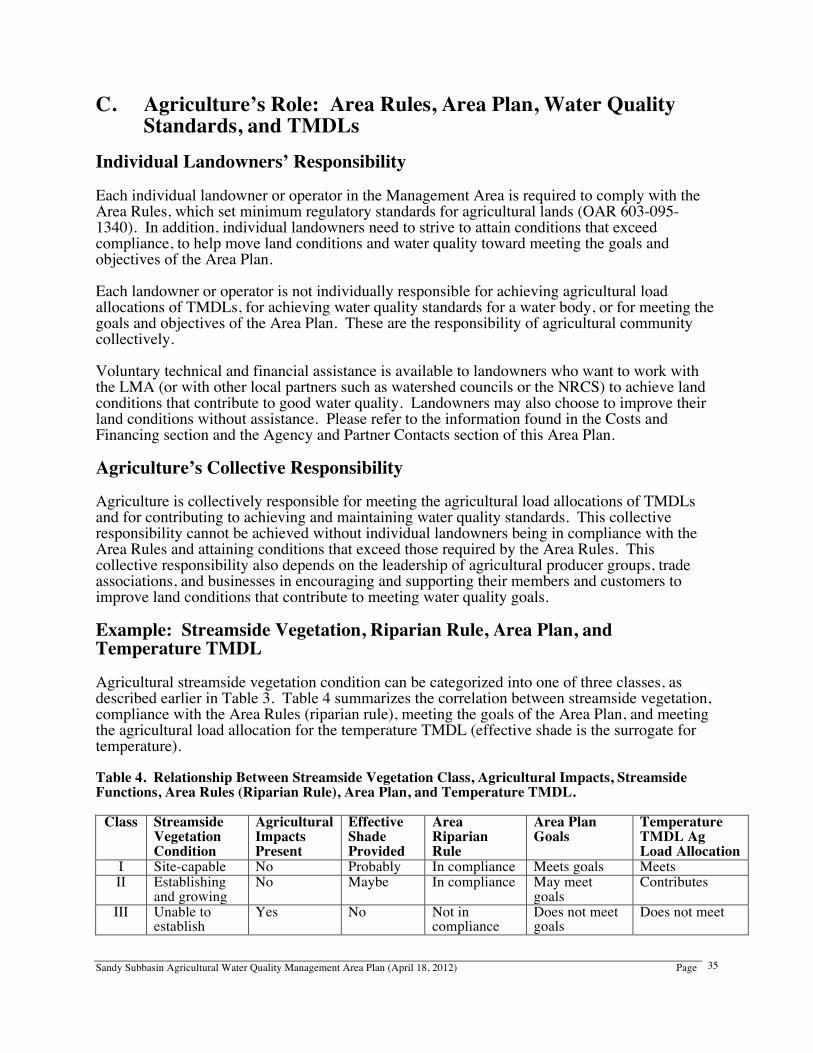
Sandy Subbasin Agricultural Water Quality Management Area Plan (April 18, 2012) Page
35
C. Agriculture’s Role: Area Rules, Area Plan, Water Quality Standards, and TMDLs
Individual Landowners’ Responsibility Each individual landowner or operator in the Management Area is required to comply with the Area Rules, which set minimum regulatory standards for agricultural lands (OAR 603-095-1340). In addition, individual landowners need to strive to attain conditions that exceed compliance, to help move land conditions and water quality toward meeting the goals and objectives of the Area Plan. Each landowner or operator is not individually responsible for achieving agricultural load allocations of TMDLs, for achieving water quality standards for a water body, or for meeting the goals and objectives of the Area Plan. These are the responsibility of agricultural community collectively. Voluntary technical and financial assistance is available to landowners who want to work with the LMA (or with other local partners such as watershed councils or the NRCS) to achieve land conditions that contribute to good water quality. Landowners may also choose to improve their land conditions without assistance. Please refer to the information found in the Costs and Financing section and the Agency and Partner Contacts section of this Area Plan. Agriculture’s Collective Responsibility Agriculture is collectively responsible for meeting the agricultural load allocations of TMDLs and for contributing to achieving and maintaining water quality standards. This collective responsibility cannot be achieved without individual landowners being in compliance with the Area Rules and attaining conditions that exceed those required by the Area Rules. This collective responsibility also depends on the leadership of agricultural producer groups, trade associations, and businesses in encouraging and supporting their members and customers to improve land conditions that contribute to meeting water quality goals. Example: Streamside Vegetation, Riparian Rule, Area Plan, and Temperature TMDL Agricultural streamside vegetation condition can be categorized into one of three classes, as described earlier in Table 3. Table 4 summarizes the correlation between streamside vegetation, compliance with the Area Rules (riparian rule), meeting the goals of the Area Plan, and meeting the agricultural load allocation for the temperature TMDL (effective shade is the surrogate for temperature). Table 4. Relationship Between Streamside Vegetation Class, Agricultural Impacts, Streamside Functions, Area Rules (Riparian Rule), Area Plan, and Temperature TMDL.
Class Streamside Vegetation Condition
Agricultural Impacts Present
Effective Shade Provided
Area Riparian Rule
Area Plan Goals
Temperature TMDL Ag Load Allocation
I Site-capable No Probably In compliance Meets goals Meets II Establishing
and growing No Maybe In compliance May meet
goals Contributes
III Unable to establish
Yes No Not in compliance
Does not meet goals
Does not meet
Sandy Subbasin Agricultural Water Quality Management Area Plan (April 18, 2012) Page
36
Class I areas have site-capable streamside vegetation, or sufficient vegetation to provide water quality functions. Agriculture is not impacting the streamside area. Effective shade is present (along with streambank stability and filtering of overland flows, which contribute to meeting the bacteria TMDL and other water quality standards). Class I areas are in compliance with the Area Rules (riparian rule) and meet the streamside vegetation goals of the Area Plan. If agricultural lands collectively have streamside vegetation in Class I condition, then agriculture is doing its part to meet the agricultural load allocation for the temperature TMDL. If these Class I conditions still do not result in the achievement of water quality standards, and there are no other agricultural nonpoint sources of the pollutants, then DEQ will reevaluate agriculture’s load allocation. Class II areas have streamside vegetation that is establishing and growing, but is not sufficient to protect water quality. Agriculture is not impacting the streamside area. Effective shade may or may not be present, depending on stream width. The streamside area may provide some streambank stability and filtration of overland flows, which contribute to meeting the bacteria TMDL and other water quality standards. Class II areas are in compliance with the Area Rules (riparian rule), may meet the streamside vegetation goals of the Area Plan, and may contribute to meeting the agriculture load allocation for the temperature TMDL. Class III areas do not have streamside vegetation that is able to establish and grow. Agriculture is impacting the streamside area. Effective shade is probably not present. The streamside area probably does not provide streambank stability or filtration of overland flows. Class III areas are not in compliance with the Area Rules (riparian rule), do not meet the streamside vegetation goals of the Area Plan, and do not contribute to meeting the agricultural load allocation for the temperature TMDL. D. Pesticide Management The ODA Pesticides Program holds the primary responsibility for pesticide registration and use regulation within the state of Oregon under the Federal Insecticide Fungicide Rodenticide Act (FIFRA). Because the EPA designated the state as the lead agency for pesticides, ODA is responsible for overseeing the development and implementation of a Pesticide Management Plan (PMP) for the state of Oregon as stipulated in the annual EPA/ODA Consolidated Pesticide Cooperative Agreement. In 2007, the interagency Water Quality Pesticides Management Team (WQPMT) was formed to address pesticide-relate water quality issues. Representatives from ODA, DEQ, the Oregon Department of Forestry (ODF), and the Oregon Health Authority (OHA) developed the PMP. The Oregon PMP sets forth a process for assessing, preventing, and responding to pesticide detections in Oregon’s ground and surface water resources by managing the pesticides that are currently registered in Oregon, in both the agricultural and non-agricultural settings. Pesticides that are no longer marketed, also called “legacy” pesticides, are regulated through a separate process under the Clean Water Act. The PMP strives to protect waters of the state from pesticide contamination, while recognizing the important role that pesticides have in maintaining a strong state economy, managing natural resources, and preventing human disease. For current or future pesticide monitoring conducted by USGS, DEQ, or other agencies, the WQPMT can assess the results relative to benchmarks and other factors the team has identified. This information can be used by ODA, the LMAs, and the LAC to assist with developing pesticide management strategies for specific chemicals and streams.
Sandy Subbasin Agricultural Water Quality Management Area Plan (April 18, 2012) Page
37
13. Monitoring and Evaluation A. Statewide Monitoring and Evaluation of Water Quality and
Streamside Conditions on Agricultural Lands ODA conducts monitoring at the statewide level and analyzes other agencies’ and organizations’ monitoring data to answer several questions related to agriculture and water quality:
• What are the current water quality and landscape conditions in agricultural areas? • What are the trends in water quality and landscape condition in agricultural areas? • How well does the existing monitoring network assess agricultural water quality and
landscape conditions and trends? • What are the trends in streamside vegetation along agricultural lands? • How do streamside vegetation conditions compare with site capabilities? • How do changes in streamside vegetation condition compare with trends in water
quality? To answer these questions, ODA evaluates water quality data from existing monitoring sites in DEQ’s Laboratory Analytical Storage And Retrieval (LASAR) database (http://deq12.deq.state.or.us/lasar2/) that reflect agricultural influence on water quality. In 2011, ODA received funding from the Oregon Legislature for water quality sampling at 19 additional agriculturally influenced sites around Oregon. Data from the new sites will also be published in the LASAR database and evaluated to determine trends in water quality at agricultural sites statewide. In addition, in each Agricultural Water Quality Management Area, ODA evaluates aerial photos of stream segments that are selected at random along agricultural lands. Based on the streamside vegetation present at the time of the assessment, each stream segment receives a score. The same stream segments are photographed and re-scored every five years to evaluate changes in streamside vegetation conditions over time. B. Monitoring, Evaluation, and Modification of the Area Plan Water Quality Data Assessment The LMAs participate in water quality monitoring efforts related to the Area Plan in consultation with ODA, OSU Extension, DEQ, city of Portland, Multnomah County, and other watershed partners such as Clackamas County, Sandy River Basin Watershed Council, and the U.S. Forest Service. Other state and federal agencies have monitored water quality in the past. For each Management Area, ODA currently evaluates other agencies’ and organizations’ water quality data to answer several questions. Data are reviewed every two years and summarized to the LAC and LMAs during the biennial review process.
• What water quality and land condition data from agricultural watersheds are available? • What are the trends in available water quality and land condition data in agricultural
watersheds since Area Plan and Area Rule adoption? • What are the trends in available water quality and land condition data in agricultural
watersheds since the last biennial review?
Sandy Subbasin Agricultural Water Quality Management Area Plan (April 18, 2012) Page
38
According to ODA’s water quality summary for the Sandy Subbasin (dated December 2011), due to the scattered nature of agricultural land in the Subbasin, it is difficult to find monitoring sites that represent cumulative agricultural influences. There are no sites in the LASAR database that are appropriate for assessing agricultural impacts to water quality. A potential monitoring location for characterizing agricultural influences might be on Beaver Creek near 282nd Avenue. East Multnomah SWCD is developing a water quality monitoring plan for Beaver Creek to help prioritize the delivery of their StreamCare program to landowners and to assess trends over time. Land Condition Assessment ODA and the LMAs will work together to conduct land condition assessments at the Management Area level. Specifically, ODA, the LMAs, and other partners will conduct an assessment of streamside vegetation conditions along agricultural lands in the Management Area by the next biennial review (2014). This assessment will allow ODA, the LMAs, and other partners to track improvements in streamside vegetation conditions over time. Often, improvements in land conditions are detectable much earlier than changes in water quality. For example, when a landowner restores a streamside area, land conditions improve rapidly, even though it may take 10-20 years for streamside vegetation to reach the height where it can provide shade to positively affect stream temperatures. For the Sandy Subbasin, ODA was not able to identify an appropriate agricultural area for conducting the periodic aerial-photo based assessments of streamside vegetation. However, ODA did provide funding for the East Multnomah SWCD to collect aerial photographs of the Beaver Creek area in 2009. It may be worthwhile to repeat the aerial photographs in the future, to evaluate the effectiveness of program implementation in the area. Implementation Activities Assessment During the biennial review process, ODA, the LMAs, and the LAC assess the effectiveness of activities that have occurred to help achieve the Area Plan’s goals and objectives, including the following:
• Outreach and education conducted to promote awareness of water quality issues and encourage agricultural land conditions that protect water quality, and the level of participation in these activities
• Voluntary conservation projects installed by agricultural landowners and managers in cooperation with the LMAs and other agencies and organizations
• Number of complaint investigations, the result of each complaint investigation, and corrections of violations
Area Plan and Area Rules Effectiveness Evaluation ODA, the LMAs, and the LAC will evaluate the effectiveness of the Area Plan in improving water quality and related land conditions. The results of the evaluation will be included in biennial reports to the Oregon Board of Agriculture. ODA, the LMAs, and the LAC will discuss the monitoring and evaluation results at each biennial review, including what these results mean in terms of Area Plan effectiveness, and modifications to the Area Plan and Area Rules. For Area Plan effectiveness, questions to discuss include:
• Are all of our goals and objectives measurable? • Were the activities that we committed to over the previous two years (in our goals,
objectives, and strategies) accomplished?
Sandy Subbasin Agricultural Water Quality Management Area Plan (April 18, 2012) Page
39
• Were our goals and objectives for land condition improvements met? • Are water quality data from agricultural lands showing improvement? • How do water quality and land condition data trends compare? • Do we need to start collecting other kinds of water quality or land condition data?
For Area Rules effectiveness, questions to discuss include:
• Were all violations that were found during investigations resolved or are they in the process of being resolved?
• Are the Area Rules consistent with meeting water quality standards and TMDL load allocations?
Priority Area Monitoring and Evaluation As described in the section on “Strategies to Achieve Goals and Objectives”, ODA, the LMAs, and the LAC are working together to identify priority areas to focus efforts for each two-year period between biennial reviews. In the Sandy Subbasin Management Area, ODA and the LMAs are initially focusing on streamside vegetation condition. At each biennial review, ODA, the LMAs, and the LAC will evaluate the effectiveness of the focused voluntary efforts in the priority area, and recommend next steps. Some of the questions to discuss include:
• What are the baseline and post-implementation percentages of agricultural streamside areas in the priority area that are:
o Class I - Streamsides have site-capable vegetation o Class II - Streamsides allow streamside vegetation to establish, but the vegetation
has not reached site-capable conditions o Class III - Agricultural activities may prevent establishment of streamside
vegetation • Was the LMA able to contact and meet with all landowners in the priority area with Class
III conditions? Are all of these agricultural landowners making improvements? • Can Class III land conditions in the priority area be addressed solely through voluntary
outreach, education, and technical / financial assistance over a two-year period? • Are land condition changes in the priority area effective in improving water quality?
Sandy Subbasin Agricultural Water Quality Management Area Plan (April 18, 2012) Page
40
14. Costs and Financing Costs of implementing this Area Plan are difficult to assess in the absence of detailed, site-specific inventories of resource problems and proposed solutions. To implement this Area Plan, the LMAs will need support and resources for staff to coordinate with Management Area partners to conduct the following:
• Educational programs (production and presentation) • Identification of high priority areas for implementation • Ongoing evaluation of Area Plan progress toward preventing and controlling water
pollution from agricultural lands and achieving water quality standards • Coordinated planning and implementation activities with other agencies, organizations,
and individuals working on similar goals • Watershed assessments • Water quality monitoring • Meeting management and facilitation
Technical and cost-sharing assistance for installation of certain management practices may be available through current USDA conservation programs such as Environmental Quality Incentive Program (EQIP) and Conservation Reserve Program (CRP), the EPA’s nonpoint source implementation grants (“319” grants), state grant programs with OWEB, or the Conservation Reserve Enhancement Program (CREP) – which is delivered through a USDA-OWEB partnership. Other agencies or organizations may also be available to provide technical assistance or financial assistance to private landowners. The effectiveness of implementation of the Area Plan will be directly tied to the level of available funding for this purpose.
Sandy Subbasin Agricultural Water Quality Management Area Plan (April 18, 2012) Page
41
15. References Gerig, A.J. 1985. Soil Survey of Clackamas County, Oregon. United States Department of Agriculture-Soil Conservation Service, Washington D.C. Greber, Lisa. 1999. Sandy Basin Management Area Ownership Map. United States Department of Agriculture-Natural Resources Inventory, Beaverton, OR. Green, G.L. 1983. Soil Survey of Multnomah County, Oregon. United States Department of Agriculture – Soil Conservation Service, Washington D.C. Mershon, Clarence. 1999. Personal Communication. June 10, 1999. Local Historian. National Marine Fisheries Service (2001). ESA Status of West Coast Salmon and Steelhead. Seattle, WA. Oregon Department of Environmental Quality. Sandy River Basin Total Maximum Daily Load TMDL. 2005. Portland, OR. Oregon Department of Fish and Wildlife. 2008. Sensitive Species List (www.dfw.state.or.us/wildlife/diversity/species/docs/SSL_by_taxon.pdf), Salem, OR. Oregon Department of Fish and Wildlife. No date; accessed 1/12/12. Threatened, Endangered, and Candidate Fish and Wildlife Species in Oregon (pdf). Salem, OR. Oregon Water Resources Department. 1991. Sandy Basin Report. Salem, OR. Oregon Watershed Enhancement Board. 1999. Oregon Aquatic Habitat Restoration and Enhancement Guide, Oregon Plan for Salmon and Watersheds. Salem, OR. Portland Water Bureau. 2010. Water Management & Conservation Plan. Portland, OR. Sandy River Basin Watershed Council. 1999. Phase 1 Watershed Assessment and Action Plan for the Sandy River Basin. Sandy River Basin Watershed Council, Sandy, OR. Taylor, George. 1999. Personal Communication. February 1, 1999. State Climatologist. United States Geological Society and U.S. Environmental Protection Agency, 1999. National Land Cover Data, Oregon. Raytheon STX Corporation, under US Geological Survey Contract 1434-CR-97-CN-4074. Yee, Dennis. 1998. Metro 2017 Regional Forecast & TAZ Allocation. Metro, Portland, Oregon.
Sandy Subbasin Agricultural Water Quality Management Area Plan (April 18, 2012) Page
42
16. APPENDICES
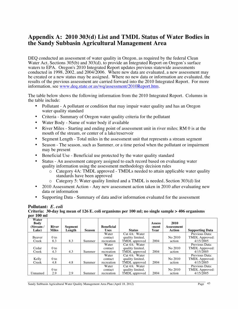
Sandy Subbasin Agricultural Water Quality Management Area Plan (April 18, 2012) Page
43
Appendix A: 2010 303(d) List and TMDL Status of Water Bodies in the Sandy Subbasin Agricultural Management Area DEQ conducted an assessment of water quality in Oregon, as required by the federal Clean Water Act, Sections 305(b) and 303(d), to provide an Integrated Report on Oregon’s surface waters to EPA. Oregon's 2010 Integrated Report updates previous statewide assessments conducted in 1998, 2002, and 2004/2006. Where new data are evaluated, a new assessment may be created or a new status may be assigned. Where no new data or information are evaluated, the results of the previous assessment are carried forward into the 2010 Integrated Report. For more information, see www.deq.state.or.us/wq/assessment/2010Report.htm. The table below shows the following information from the 2010 Integrated Report. Columns in the table include:
• Pollutant - A pollutant or condition that may impair water quality and has an Oregon water quality standard
• Criteria - Summary of Oregon water quality criteria for the pollutant • Water Body - Name of water body if available • River Miles - Starting and ending point of assessment unit in river miles; RM 0 is at the
mouth of the stream, or center of a lake/reservoir • Segment Length - Total miles in the assessment unit that represents a stream segment • Season - The season, such as Summer, or a time period when the pollutant or impairment
may be present • Beneficial Use - Beneficial use protected by the water quality standard • Status - An assessment category assigned to each record based on evaluating water
quality information using the assessment methodology decision rules o Category 4A: TMDL approved - TMDLs needed to attain applicable water quality
standards have been approved o Category 5: Water quality limited and a TMDL is needed, Section 303(d) list
• 2010 Assessment Action - Any new assessment action taken in 2010 after evaluating new data or information
• Supporting Data - Summary of data and/or information evaluated for the assessment Pollutant: E. coli Criteria: 30-day log mean of 126 E. coli organisms per 100 ml; no single sample > 406 organisms per 100 ml
Water Body
(Stream / Lake)
River Miles
Segment Length Season
Beneficial Uses Status
Assess-ment Year
2010 Assessment
Action Supporting Data
Beaver Creek
0 to 8.3 8.3 Summer
Water contact
recreation
Cat 4A: Water quality limited,
TMDL approved 2004 No 2010
action
Previous Data: TMDL Approved:
4/15/2005
Cedar Creek
0 to 4.3 4.3 Summer
Water contact
recreation
Cat 4A: Water quality limited,
TMDL approved 2004 No 2010
action
Previous Data: TMDL Approved:
4/15/2005
Kelly Creek
0 to 4.8 4.8 Summer
Water contact
recreation
Cat 4A: Water quality limited,
TMDL approved 2004 No 2010
action
Previous Data: TMDL Approved:
4/15/2005
Unnamed 0 to 2.9 2.9 Summer
Water contact
recreation
Cat 4A: Water quality limited,
TMDL approved 2004 No 2010
action
Previous Data: TMDL Approved:
4/15/2005
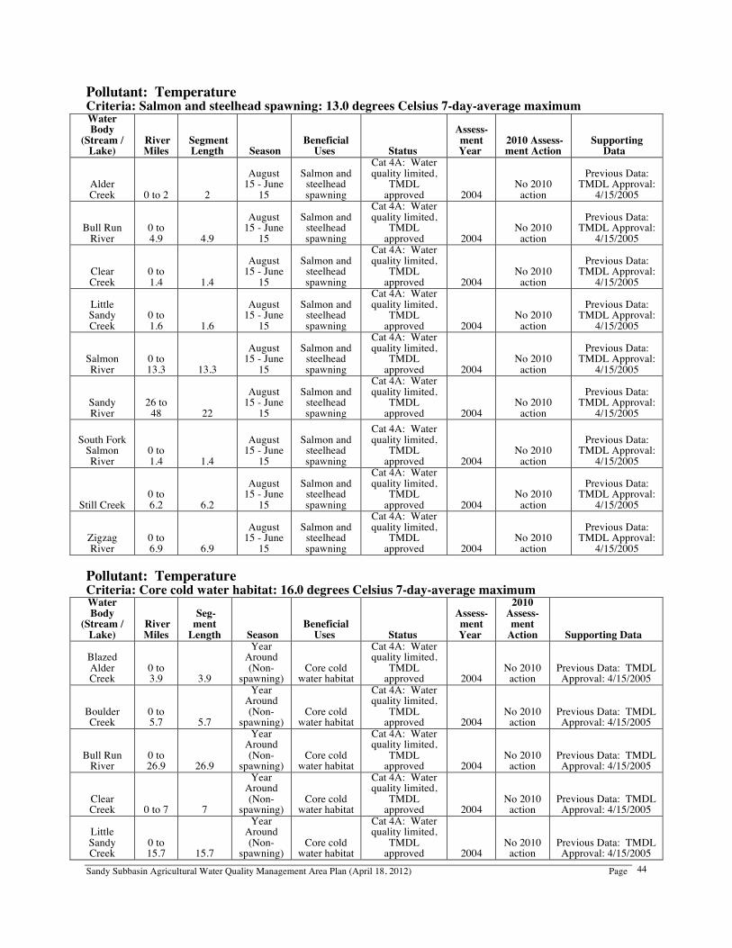
Sandy Subbasin Agricultural Water Quality Management Area Plan (April 18, 2012) Page
44
Pollutant: Temperature Criteria: Salmon and steelhead spawning: 13.0 degrees Celsius 7-day-average maximum Water Body
(Stream / Lake)
River Miles
Segment Length Season
Beneficial Uses Status
Assess- ment Year
2010 Assess-ment Action
Supporting Data
Alder Creek 0 to 2 2
August 15 - June
15
Salmon and steelhead spawning
Cat 4A: Water quality limited,
TMDL approved 2004
No 2010 action
Previous Data: TMDL Approval:
4/15/2005
Bull Run River
0 to 4.9 4.9
August 15 - June
15
Salmon and steelhead spawning
Cat 4A: Water quality limited,
TMDL approved 2004
No 2010 action
Previous Data: TMDL Approval:
4/15/2005
Clear Creek
0 to 1.4 1.4
August 15 - June
15
Salmon and steelhead spawning
Cat 4A: Water quality limited,
TMDL approved 2004
No 2010 action
Previous Data: TMDL Approval:
4/15/2005
Little Sandy Creek
0 to 1.6 1.6
August 15 - June
15
Salmon and steelhead spawning
Cat 4A: Water quality limited,
TMDL approved 2004
No 2010 action
Previous Data: TMDL Approval:
4/15/2005
Salmon River
0 to 13.3 13.3
August 15 - June
15
Salmon and steelhead spawning
Cat 4A: Water quality limited,
TMDL approved 2004
No 2010 action
Previous Data: TMDL Approval:
4/15/2005
Sandy River
26 to 48 22
August 15 - June
15
Salmon and steelhead spawning
Cat 4A: Water quality limited,
TMDL approved 2004
No 2010 action
Previous Data: TMDL Approval:
4/15/2005
South Fork Salmon River
0 to 1.4 1.4
August 15 - June
15
Salmon and steelhead spawning
Cat 4A: Water quality limited,
TMDL approved 2004
No 2010 action
Previous Data: TMDL Approval:
4/15/2005
Still Creek 0 to 6.2 6.2
August 15 - June
15
Salmon and steelhead spawning
Cat 4A: Water quality limited,
TMDL approved 2004
No 2010 action
Previous Data: TMDL Approval:
4/15/2005
Zigzag River
0 to 6.9 6.9
August 15 - June
15
Salmon and steelhead spawning
Cat 4A: Water quality limited,
TMDL approved 2004
No 2010 action
Previous Data: TMDL Approval:
4/15/2005 Pollutant: Temperature Criteria: Core cold water habitat: 16.0 degrees Celsius 7-day-average maximum Water Body
(Stream / Lake)
River Miles
Seg- ment
Length Season Beneficial
Uses Status
Assess- ment Year
2010 Assess-ment
Action Supporting Data
Blazed Alder Creek
0 to 3.9 3.9
Year Around (Non-
spawning) Core cold
water habitat
Cat 4A: Water quality limited,
TMDL approved 2004
No 2010 action
Previous Data: TMDL Approval: 4/15/2005
Boulder Creek
0 to 5.7 5.7
Year Around (Non-
spawning) Core cold
water habitat
Cat 4A: Water quality limited,
TMDL approved 2004
No 2010 action
Previous Data: TMDL Approval: 4/15/2005
Bull Run River
0 to 26.9 26.9
Year Around (Non-
spawning) Core cold
water habitat
Cat 4A: Water quality limited,
TMDL approved 2004
No 2010 action
Previous Data: TMDL Approval: 4/15/2005
Clear Creek 0 to 7 7
Year Around (Non-
spawning) Core cold
water habitat
Cat 4A: Water quality limited,
TMDL approved 2004
No 2010 action
Previous Data: TMDL Approval: 4/15/2005
Little Sandy Creek
0 to 15.7 15.7
Year Around (Non-
spawning) Core cold
water habitat
Cat 4A: Water quality limited,
TMDL approved 2004
No 2010 action
Previous Data: TMDL Approval: 4/15/2005
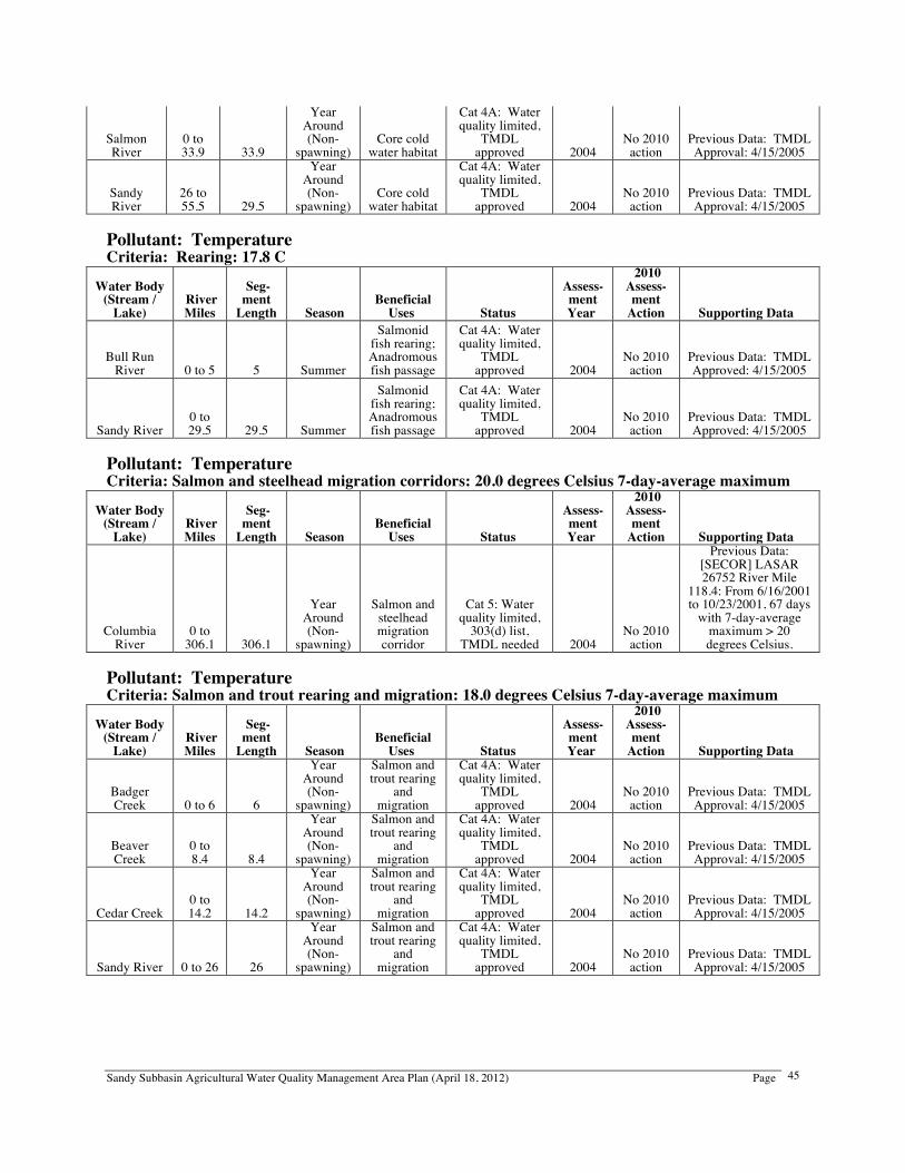
Sandy Subbasin Agricultural Water Quality Management Area Plan (April 18, 2012) Page
45
Salmon River
0 to 33.9 33.9
Year Around (Non-
spawning) Core cold
water habitat
Cat 4A: Water quality limited,
TMDL approved 2004
No 2010 action
Previous Data: TMDL Approval: 4/15/2005
Sandy River
26 to 55.5 29.5
Year Around (Non-
spawning) Core cold
water habitat
Cat 4A: Water quality limited,
TMDL approved 2004
No 2010 action
Previous Data: TMDL Approval: 4/15/2005
Pollutant: Temperature Criteria: Rearing: 17.8 C
Water Body (Stream /
Lake) River Miles
Seg- ment
Length Season Beneficial
Uses Status
Assess- ment Year
2010 Assess-ment
Action Supporting Data
Bull Run River 0 to 5 5 Summer
Salmonid fish rearing; Anadromous fish passage
Cat 4A: Water quality limited,
TMDL approved 2004
No 2010 action
Previous Data: TMDL Approved: 4/15/2005
Sandy River 0 to 29.5 29.5 Summer
Salmonid fish rearing; Anadromous fish passage
Cat 4A: Water quality limited,
TMDL approved 2004
No 2010 action
Previous Data: TMDL Approved: 4/15/2005
Pollutant: Temperature Criteria: Salmon and steelhead migration corridors: 20.0 degrees Celsius 7-day-average maximum
Water Body (Stream /
Lake) River Miles
Seg- ment
Length Season Beneficial
Uses Status
Assess- ment Year
2010 Assess-ment
Action Supporting Data
Columbia River
0 to 306.1 306.1
Year Around (Non-
spawning)
Salmon and steelhead migration corridor
Cat 5: Water quality limited,
303(d) list, TMDL needed 2004
No 2010 action
Previous Data: [SECOR] LASAR 26752 River Mile
118.4: From 6/16/2001 to 10/23/2001, 67 days
with 7-day-average maximum > 20 degrees Celsius.
Pollutant: Temperature Criteria: Salmon and trout rearing and migration: 18.0 degrees Celsius 7-day-average maximum
Water Body (Stream /
Lake) River Miles
Seg- ment
Length Season Beneficial
Uses Status
Assess- ment Year
2010 Assess-ment
Action Supporting Data
Badger Creek 0 to 6 6
Year Around (Non-
spawning)
Salmon and trout rearing
and migration
Cat 4A: Water quality limited,
TMDL approved 2004
No 2010 action
Previous Data: TMDL Approval: 4/15/2005
Beaver Creek
0 to 8.4 8.4
Year Around (Non-
spawning)
Salmon and trout rearing
and migration
Cat 4A: Water quality limited,
TMDL approved 2004
No 2010 action
Previous Data: TMDL Approval: 4/15/2005
Cedar Creek 0 to 14.2 14.2
Year Around (Non-
spawning)
Salmon and trout rearing
and migration
Cat 4A: Water quality limited,
TMDL approved 2004
No 2010 action
Previous Data: TMDL Approval: 4/15/2005
Sandy River 0 to 26 26
Year Around (Non-
spawning)
Salmon and trout rearing
and migration
Cat 4A: Water quality limited,
TMDL approved 2004
No 2010 action
Previous Data: TMDL Approval: 4/15/2005
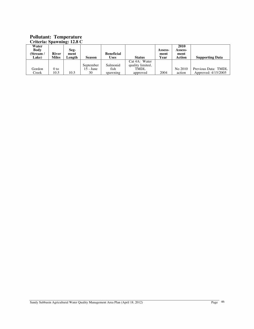
Sandy Subbasin Agricultural Water Quality Management Area Plan (April 18, 2012) Page
46
Pollutant: Temperature Criteria: Spawning: 12.8 C
Water Body
(Stream / Lake)
River Miles
Seg- ment
Length Season Beneficial
Uses Status
Assess- ment Year
2010 Assess-ment
Action Supporting Data
Gordon Creek
0 to 10.5 10.5
September 15 - June
30
Salmonid fish
spawning
Cat 4A: Water quality limited,
TMDL approved 2004
No 2010 action
Previous Data: TMDL Approved: 4/15/2005
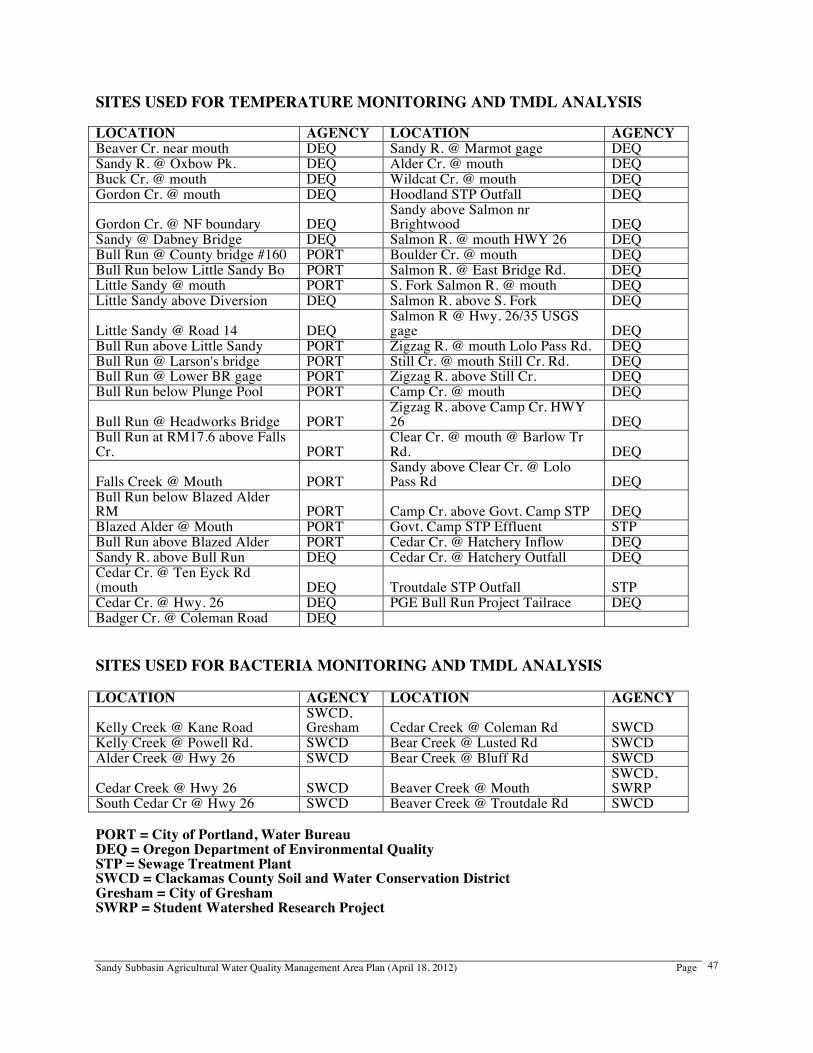
Sandy Subbasin Agricultural Water Quality Management Area Plan (April 18, 2012) Page
47
SITES USED FOR TEMPERATURE MONITORING AND TMDL ANALYSIS LOCATION AGENCY LOCATION AGENCY Beaver Cr. near mouth DEQ Sandy R. @ Marmot gage DEQ Sandy R. @ Oxbow Pk. DEQ Alder Cr. @ mouth DEQ Buck Cr. @ mouth DEQ Wildcat Cr. @ mouth DEQ Gordon Cr. @ mouth DEQ Hoodland STP Outfall DEQ
Gordon Cr. @ NF boundary DEQ Sandy above Salmon nr Brightwood DEQ
Sandy @ Dabney Bridge DEQ Salmon R. @ mouth HWY 26 DEQ Bull Run @ County bridge #160 PORT Boulder Cr. @ mouth DEQ Bull Run below Little Sandy Bo PORT Salmon R. @ East Bridge Rd. DEQ Little Sandy @ mouth PORT S. Fork Salmon R. @ mouth DEQ Little Sandy above Diversion DEQ Salmon R. above S. Fork DEQ
Little Sandy @ Road 14 DEQ Salmon R @ Hwy. 26/35 USGS gage DEQ
Bull Run above Little Sandy PORT Zigzag R. @ mouth Lolo Pass Rd. DEQ Bull Run @ Larson's bridge PORT Still Cr. @ mouth Still Cr. Rd. DEQ Bull Run @ Lower BR gage PORT Zigzag R. above Still Cr. DEQ Bull Run below Plunge Pool PORT Camp Cr. @ mouth DEQ
Bull Run @ Headworks Bridge PORT Zigzag R. above Camp Cr. HWY 26 DEQ
Bull Run at RM17.6 above Falls Cr. PORT
Clear Cr. @ mouth @ Barlow Tr Rd. DEQ
Falls Creek @ Mouth PORT Sandy above Clear Cr. @ Lolo Pass Rd DEQ
Bull Run below Blazed Alder RM PORT Camp Cr. above Govt. Camp STP DEQ Blazed Alder @ Mouth PORT Govt. Camp STP Effluent STP Bull Run above Blazed Alder PORT Cedar Cr. @ Hatchery Inflow DEQ Sandy R. above Bull Run DEQ Cedar Cr. @ Hatchery Outfall DEQ Cedar Cr. @ Ten Eyck Rd (mouth DEQ Troutdale STP Outfall STP Cedar Cr. @ Hwy. 26 DEQ PGE Bull Run Project Tailrace DEQ Badger Cr. @ Coleman Road DEQ SITES USED FOR BACTERIA MONITORING AND TMDL ANALYSIS LOCATION AGENCY LOCATION AGENCY
Kelly Creek @ Kane Road SWCD, Gresham Cedar Creek @ Coleman Rd SWCD
Kelly Creek @ Powell Rd. SWCD Bear Creek @ Lusted Rd SWCD Alder Creek @ Hwy 26 SWCD Bear Creek @ Bluff Rd SWCD
Cedar Creek @ Hwy 26 SWCD Beaver Creek @ Mouth SWCD, SWRP
South Cedar Cr @ Hwy 26 SWCD Beaver Creek @ Troutdale Rd SWCD PORT = City of Portland, Water Bureau DEQ = Oregon Department of Environmental Quality STP = Sewage Treatment Plant SWCD = Clackamas County Soil and Water Conservation District Gresham = City of Gresham SWRP = Student Watershed Research Project
Sandy Subbasin Agricultural Water Quality Management Area Plan (April 18, 2012) Page
48
Appendix B: Educational and Technical Services for Natural Resource and Farm Management Local Management Agencies (LMAs) and Local Advisory Committee (LAC) Sandy Subbasin LMAs: Soil and Water Conservation Districts (SWCDs) Assist landowners in identifying and implementing land management activities and coordinate with other technical experts in natural resources. Clackamas County (Oregon City): 503-210-6000 / www.conservationdistrict.org East Multnomah (Portland): 503-222-7645 / www.emswcd.org Sandy Subbasin Management Area Local Advisory Committee (LAC) Voluntary committee composed of twelve agricultural producers, landowners, and other stakeholders in the Management Area. Assists with developing and reviewing the Agricultural Water Quality Management Area Plan and Area Rules, in accordance with the Agricultural Water Quality Management Act. Clackamas County SWCD: 503-210-6000 / www.conservationdistrict.org Oregon Department of Agriculture 503-986-4700 / www.oregon.gov/ODA/NRD Federal Agencies USDA – Natural Resources Conservation Service (NRCS) Provides information on soil types, soils mapping, and interpretation. Administers and provides assistance in developing plans for CRP, EQIP, WRP, and other cost share programs. Makes technical determinations on wetlands and highly erodible land. Clackamas County (Oregon City): 503-655-3144 / www.or.nrcs.usda.gov/contact Multnomah County (Portland): 503-326-3941 / www.or.nrcs.usda.gov/contact USDA – Farm Service Agency (FSA) Maintains agricultural program records and administers various cost share programs. Their offices also provide up-to-date aerial photography of farm and forestland. Clackamas/Multnomah County: 503-655-3144 / www.fsa.usda.gov/or State Agencies Oregon Department of Agriculture (ODA) Oversees the Oregon Agricultural Water Quality Program, issues permits and helps producers comply with confined animal feeding water management programs, provides support to SWCDs, and investigates complaints of water pollution from agricultural lands. Natural Resources Division (Salem): 503-986-4700 / www.oregon.gov/ODA/NRD Department of Environmental Quality (DEQ) Responsible for protecting and enhancing Oregon's water and air quality, cleaning up spills and releases of hazardous materials, and managing the proper disposal of solid and hazardous wastes. Maintains a list of water quality limited streams (303(d) list), sets TMDL allocations. Portland: 800-452-4011 / www.oregon.gov/DEQ/WQ Oregon Watershed Enhancement Board (OWEB) Provides grants to help Oregonians take care of local streams, rivers, wetlands, and natural areas. Provides financial support for watershed council operations and projects. Salem: 503-986-0178 / www.oregon.gov/OWEB
Sandy Subbasin Agricultural Water Quality Management Area Plan (April 18, 2012) Page
49
Department of State Lands (DSL) Administers state removal/fill law and provides technical assistance. Salem: 503-986-5200 / www.oregon.gov/DSL Oregon Water Resources Department (WRD) Provides technical and educational assistance and water rights permits and information. Salem: 503-986-0900 / www.oregon.gov/OWRD Oregon Department of Fish and Wildlife (ODFW) Works with landowners to balance protection of fish and wildlife with economic, social, and recreational needs. Advises on habitat protection. Offers technical and educational assistance for habitat and restoration projects. Provides plan review for special property tax assessment for wildlife habitat projects. North Willamette Watershed District (Clackamas): 971-673-6000 / www.dfw.state.or.us Oregon Department of Forestry (ODF) Technical assistance with State and Federal cost sharing, Oregon property tax programs, Forest Resource Trust, forestry practices, and forest management plans. Molalla Office: 503-829-2216 / www.oregon.gov/ODF Other Partners Oregon State University Extension Service (OSU Extension) Offers educational programs, seminars, classes, tours, and publications to guide landowners in managing their resources. Clackamas County: 503-655-8631 / www.extension.oregonstate.edu/clackamas Portland Metro Area: 503-725-8101 / www.extension.oregonstate.edu/metro Sandy River Basin Watershed Council Partnership of people who live, work, or recreate in the Sandy River Basin as well as agencies and organizations that have an interest in the area, working cooperatively to improve the health of the watershed for fish, wildlife, and people. Sandy: 503-668-1646 / www.sandyriver.org
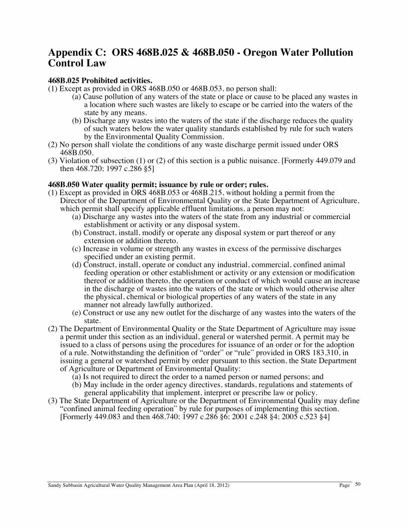
Sandy Subbasin Agricultural Water Quality Management Area Plan (April 18, 2012) Page
50
Appendix C: ORS 468B.025 & 468B.050 - Oregon Water Pollution Control Law 468B.025 Prohibited activities. (1) Except as provided in ORS 468B.050 or 468B.053, no person shall:
(a) Cause pollution of any waters of the state or place or cause to be placed any wastes in a location where such wastes are likely to escape or be carried into the waters of the state by any means.
(b) Discharge any wastes into the waters of the state if the discharge reduces the quality of such waters below the water quality standards established by rule for such waters by the Environmental Quality Commission.
(2) No person shall violate the conditions of any waste discharge permit issued under ORS 468B.050.
(3) Violation of subsection (1) or (2) of this section is a public nuisance. [Formerly 449.079 and then 468.720; 1997 c.286 §5]
468B.050 Water quality permit; issuance by rule or order; rules. (1) Except as provided in ORS 468B.053 or 468B.215, without holding a permit from the
Director of the Department of Environmental Quality or the State Department of Agriculture, which permit shall specify applicable effluent limitations, a person may not:
(a) Discharge any wastes into the waters of the state from any industrial or commercial establishment or activity or any disposal system.
(b) Construct, install, modify or operate any disposal system or part thereof or any extension or addition thereto.
(c) Increase in volume or strength any wastes in excess of the permissive discharges specified under an existing permit.
(d) Construct, install, operate or conduct any industrial, commercial, confined animal feeding operation or other establishment or activity or any extension or modification thereof or addition thereto, the operation or conduct of which would cause an increase in the discharge of wastes into the waters of the state or which would otherwise alter the physical, chemical or biological properties of any waters of the state in any manner not already lawfully authorized.
(e) Construct or use any new outlet for the discharge of any wastes into the waters of the state.
(2) The Department of Environmental Quality or the State Department of Agriculture may issue a permit under this section as an individual, general or watershed permit. A permit may be issued to a class of persons using the procedures for issuance of an order or for the adoption of a rule. Notwithstanding the definition of “order” or “rule” provided in ORS 183.310, in issuing a general or watershed permit by order pursuant to this section, the State Department of Agriculture or Department of Environmental Quality:
(a) Is not required to direct the order to a named person or named persons; and (b) May include in the order agency directives, standards, regulations and statements of
general applicability that implement, interpret or prescribe law or policy. (3) The State Department of Agriculture or the Department of Environmental Quality may define
“confined animal feeding operation” by rule for purposes of implementing this section. [Formerly 449.083 and then 468.740; 1997 c.286 §6; 2001 c.248 §4; 2005 c.523 §4]