Embed Size (px)
Citation preview
National Aeronautics and Space Administration
Santa Susana Field Laboratory Archaeological Resources Surv e yThis is a description of the survey conducted to identify and evaluate archaeological resources in the portions of the Santa Susana Field Laboratory (SSFL) that are administered by NASA.
Engines tested by NASA
at the Santa Susana
Field Laboratory (SSFL)
were the engines used in
rockets that landed
modern man on the
surface of the moon -
the same moon ancient
cultures had looked
upon for thousands of
years. Just as modern
man left footprints on
the moon’s surface,
ancient cultures left
behind cave paintings,
tools and other proof of
their presence long ago
in the Simi Hills of
Southern California.
NASA recognizes the
importance of the
historic resources and
culture of the people
who called the rocky
terrain “home” in a
place known today as
the SSFL.
NASA’s Archaeological Survey A site-wide Cultural Resources Inventory of federally-owned Areas I and II was completed in April 2008. The goals of this survey were twofold: to d e t e rmine whether there were any previously unre c ord e d c u l t u r a l resources on the lands administered by NASA, and to better understand the nature and extent of the previously recorded Burro Flats Painted Cave site (see page 3). This eff o rt assists NASA in complying with Section 110 of the National Historic Pre s e rvation Act (NHPA ) , which directs Federal agencies to identify historic pro p e rties, including archaeological re s o u rces. Having this compre h e n s i v e inventory enables NASA to better manage these resources.
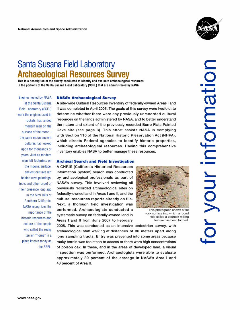
Archival Search and Field Investigation A CHRIS (California Historical Resourc e s Information System) search was conducted by archaeological professionals as part of NASA’s survey. This involved reviewing all previously recorded archaeological sites on federally-owned land in Areas I and II, and the cultural re s o u rces re p o rts already on file. Next, a thorough field investigation was p e rf o rmed. Archaeologists conducted a This photograph sho
systematic survey on federally-owned land in Areas I and II from June 2007 to February 2008. This was conducted as an intensive pedestrian survey, with archaeological staff walking at distances of 30 meters apart along long sampling tracts. Entry was prevented into some areas because rocky terrain was too steep to access or there were high concentrations of poison oak. In these, and in the areas of developed land, a visual inspection was perf o rmed. Archaeologists were able to evaluate a p p roximately 80 percent of the acreage in NASA’s Area I and 40 percent of Area II.
rock surface into which hole called a bedroc
feature has been
ws a flat a round k milling formed.
www.nasa.gov
legends
The prehistory of Southern California can be divided into four main horizons, or “cultural periods” - Early Man, Milling Stone, Intermediate and Late Prehistoric.
Early Man End of Ice Age to 6000 B.C.
Milling Stone 6000 B.C. to 1000 B.C. (earliest documented in Ventura County)
Intermediate 1000 B.C. to A.D. 750
Late Prehistoric A.D. 750 to 1769
Prehistory of the SSFL
SSFL is located in southeastern Ventura County near the crest of the Simi Hills that are part of the
Santa Monica Mountains running east-west across Southern California. These mountains consist
of sedimentary rocks estimated to be 8 to 70 million years old. The diverse terrain consists of
ridges, canyons and sandstone rock outcrops.
The scenic, rocky areas surrounding the SSFL
have a rich cultural history ranging from ancient
villages and Native American cave paintings to
of bandits and buried tre a s u re, train
robberies, and perilous stage rides. The diverse
topography and geology reflect many distinct
habitats, each with its own suite of natural
re s o u rces. Because of this enviro n m e n t a l
d i v e r s i t y, the region was intensively
occupied by Native Americans from the earliest Chumash, Tongva and Tataviam cultures. As
such, the SSFL contains native pictographs and other sites with significant archaeological
resources, both in terms of science and culture.
The initial occupation of Southern California took place during the Early Man horizon. Artifact
assemblages (collections) dating to this horizon contain large projectile points and scrapers
providing evidence that the earliest inhabitants probably hunted and gathered for subsistence
and lived in small nomadic groups.
Assemblages from the Milling Stone horizon, the earliest documented cultural period in Ventura
County, include hand stones and milling stones, which indicate a diet based on plant foods.
Artifacts include choppers and scrapers, but few projectile points. Archaeological sites from this
horizon suggest that groups were semi-sedentary and occupied base camps for a portion
of the year.
There are few archaeological data for the
Intermediate horizon period, particularly for
the inland regions of Southern California. It is
a period similar to the Milling Stone, but
assemblages include large stemmed or
notched projectile points and mortars and
pestles. The presence of projectile points
indicates an increased emphasis on hunting,
while the mortars and pestles indicate that
the people harvested and processed acorns.
An increase in population and a transition to
a more semi-sedentary lifestyle occurred
during the Late Prehistoric horizon.
Archaeological assemblages include small
projectile points, which indicate the use of
the bow and arrow, as well as stealite bowls,
asphaltum (used to waterproof canoes),
grave goods and shell ornaments. Bedrock
milling stations, such as those at the Burro
Flats Painted Cave site, were common.
The areas surrounding Ventura County and the Simi Hills
have been identif ied as a transition zone between
t h e t e r r i t o r i e s o f t h e Ve n t u re ñ o / C h u m a s h , t h e
G a b r i e l i n o / Tongva and the Fern a n d e ñ o / Tataviam. Most
groups w e re organized in hunter/gatherer societies that
were semi-nomadic throughout the region. Often they did
not establish permanent villages; instead they occupied
various regions and set up camp seasonally. ■
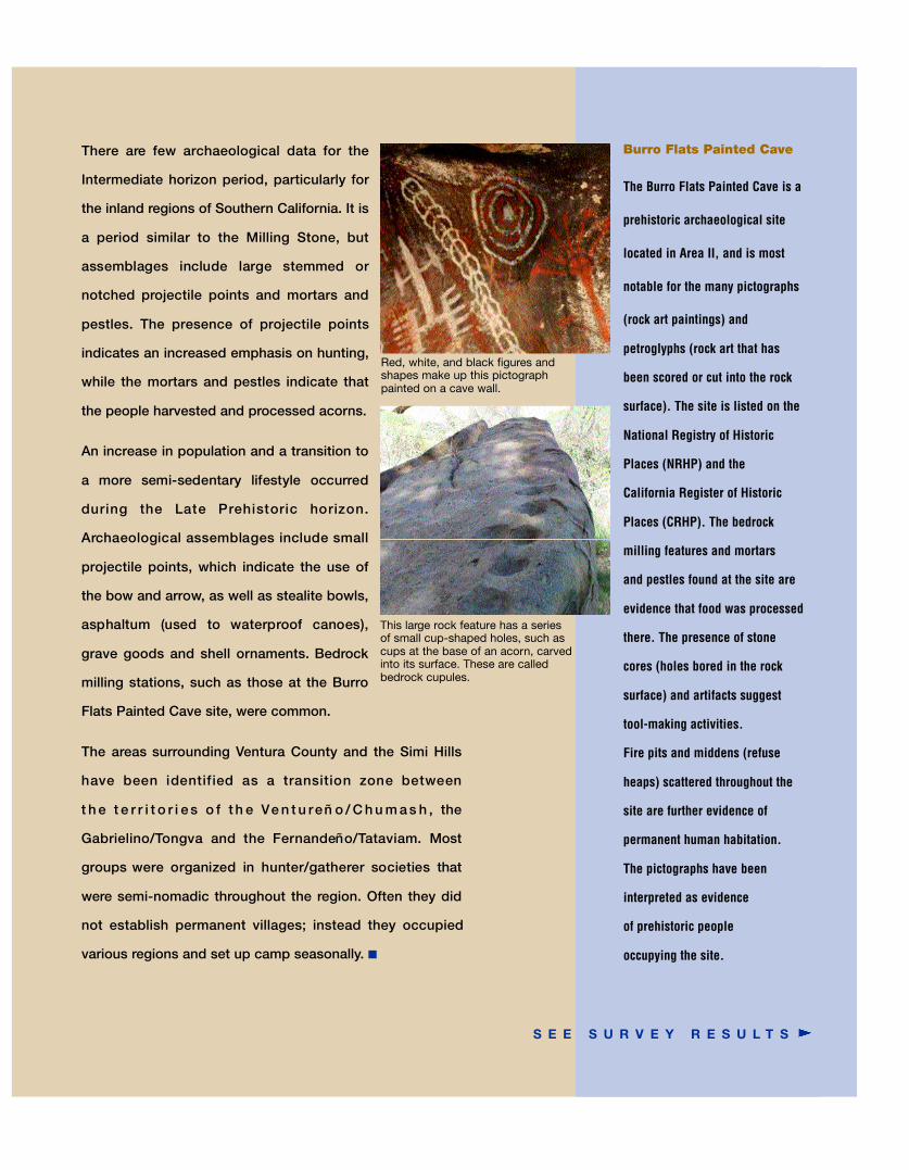
Red, white, and blac k figures and shapes make up this pictographpainted on a cave w all.
This large rock featur e has a series of small cup-shaped holes, such as cups at the base of an acorn, carved into its surface. Thes e are called bedrock cupules.
Burro Flats Painted Cave
The Burro Flats Painted Cave is a
prehistoric archaeological site
located in Area II, and is most
notable for the many pictographs
(rock art paintings) and
petroglyphs (rock art that has
been scored or cut into the rock
surface). The site is listed on the
National Registry of Historic
Places (NRHP) and the
California Register of Historic
Places (CRHP). The bedrock
milling features and mortars
and pestles found at the site are
evidence that food was processed
there. The presence of stone
cores (holes bored in the rock
surface) and artifacts suggest
tool-making activities.
Fire pits and middens (refuse
heaps) scattered throughout the
site are further evidence of
permanent human habitation.
The pictographs have been
interpreted as evidence
of prehistoric people
occupying the site.
S E E S U R V E Y R E S U L T S
Survey Results
The Cultural Resources Inventory recommended two archaeological sites as eligible for listing in
the National Registry of Historic Places and the California Registry of Historic Places. The first site,
Burro Flats Painted Cave, was already listed. NASA’s survey examined all recorded studies of the
Burro Flats Painted Cave and incorporated the 25 identified features into one report. The site
boundary was re-drawn to encompass the locations of all features of the site and the artifacts. The
total area of the site on federal property is approximately 10 acres.
A second site was reported as eligible for listing. The California State Historic Preservation Officer
(SHPO) did not concur with eligibility because of the lack of artifacts that would substantiate the
site. SHPO requested that NASA treat the site as eligible for listing in the California Registry and
re-evaluate the site later should there be a proposed project with a potential to cause disturbance.
Survey results consistent with the SHPO comments were finalized and sent to the California State
University at Fullerton for archival purposes.
Having completed the archaeological resources survey, NASA now has an inventory of the historic
and prehistoric resources located on federal lands in Areas I and II. (A separate information
sheet describing NASA’s Historic Resources Survey is available.) This inventory provides NASA
with the location and details necessary to develop ways to protect and manage these treasured
resources. ■
F o r f u r t h e r i n f o r m a t i o n , p l e a s e c o n t a c t
Merrilee Fellows NASA Manager for Community Involvement S A N TA S U S A N A F I E L D L A B O R AT O RY Phone (818) 393-0754 Email [email protected] Web site http://ssfl.msfc.nasa.gov
SSFL-2010-03-30 PRINTED ON RECYCLED PAPER