Embed Size (px)
Citation preview

Acta Astronautica Vol. 9, No. 8, pp. 507-514, 1982 0094-57651821080507-.08503.0010 Printed in Great Britain. Pergamon Press Ltd.
SATELLITE AUGMENTATION OF CELLULAR TYPE MOBILE RADIO TELEPHONE SYSTEMSt
RoY E. ANDERSON General Electric Company, Corporate Research and Development, Schenectady, NY 12301, U.S.A.
(Received 4 March 1982)
A~tract--NASA's ATS-6 satellite relayed voice bandwidth communications between five trucks and the trucking company dispatchers as the trucks traveled throughout the north-eastern quarter of the contiguous United States. The experiment, conducted over a seven month period, demonstrated that propagation characteristics are much different for the satellite-mobile links than for terrestrial-mobile links. A properly designed satellite system can provide high quality, reliable voice and data communications except where the vehicle-satellite path is shadowed by a structure or terrain feature. Mobile equipment in the experiment was adapted from commercial mobile radios. The vehicle antennas were 75 cm tall, 2 cm diam.
Another experiment proved the feasibility of vehicle position surveillance using active two-way tone-code ranging through ATS-6 to provide one line of position and passive one-way ranging by measuring the time-of- arrival of a signal from an independent satellite. A position fix was printed out at an earth station 1 sec after it sent the interrogation signal to the distant vehicle, a towboat on the Mississippi River. The line of position from ATS-6 was accurate to 0.1 nautical mile using a voice bandwidth ranging signal. The line of position from the NOAA GOES satellite was accurate to 2 miles, using 100 Hz signal bandwidth. If the signal from the independent satellite had the same bandwidth and signal-to-noise ratio as ATS-6, the fixes would have been accurate to about 0.1 nautical mile.
A concept study concluded that satellites might be a cost effective augmentation of terrestrial cellular type mobile radio telephone systems. The satellites would serve thinly populated areas where terrestrial systems are not cost effective. In the United States, the satellites would serve about 90% of the land area where 20% of the population resides. A multibeam satellite with many channels in each beam would be compatible with the urban terrestrial systems and together they would provide a nearly ubiquitous mobile radio telephone service.
I. INTRODUCTION
Cellular type mobile radio telephone systems will satisfy the presently unfulfilled demand for mobile telephone service in cities. The terrestrially based, computer-con- trolled systems with their many interconnected fixed transmitter-receivers are expensive and cost effective only where population density is high. Less expensive, single cell installations might extend the service to smaller cities. A satellite augmentation of the ter- restrially-based cellular systems may be a cost effective way to extend the service to all the remaining area of a nation.
Experiments with NASA's Application Technology Satellites have demonstrated the technical feasibility of satellite-aided land mobile radio, and their use in demon- strations and emergencies has revealed how satellites can satisfy some important needs for mobile radio telephone service in areas where terrestrial systems are not likely to be installed.
When Mt. St. Helens in the state of Washington erup- ted, a jeep equipped for communications through ATS-3 was quickly dispatched to the scene. It communicated through the satellite with an earth station in New York State where telephone interconnections were made. The link carried vital communications during the first few days until other communications could be established.
tPaper presented at the XXXIInd Congress of the Inter- national Astronautical Federation, Rome, Italy, 7-12 September 1981.
Advanced life support is now provided by some am- bulance services. A trained paramedic can administer emergency medical procedures if he is in communication with a doctor at the hospital. ATS-3 is used in an advanced life support system in rural areas of three southern states [1, 2].
Long distance transportation services; highway, rail and inland waterways, have needs for mobile com- munications on routes through thinly populated areas. Inventory control, load dispatching, cargo brokering be- tween carriers, safety and maintenance are some of the functions that mobile communications can provide. A need has been expressed for automatic position sur- veillance of trucks to minimize theft losses.
Agriculture and forestry have needs for mobile radio telephones in rural and remote areas. Purchasing agents for food processors and commodity markets need im- mediate access to pricing information as they deal with farmers and ranchers.
Oil drilling and mineral exploration need undelayed data communications between remote locations and cen- tral processors.
The need for the service is evident. Technical feasi- bility of satellite-aided service has been demonstrated. A study conducted for NASA and summarized in this paper suggests that it may be cost effective. Further investigations will compare terrestrial and satellite ap- proaches to the ubiquitous radio telephone service and will examine regulatory and institutional aspects of the service.
507
508 Roy E.
International interest in satellite-aided mobile radio is shown by the Swedish "Trucksat" concept. It is reported that studies are underway in Canada and by the Euro- pean Space Agency. If demonstrations and studies con- tinue to show that the service is needed and is cost effective, satellite-aided land mobile radio may be another valuable application of space technology for many nations.
2. LONG DISTANCE TRANSPORTATION
EXPERIMENTS
The L-band transponder of NASA's ATS-6 geosta- tionary satellite was used in a communication experiment with five trucks in commercial service, and a com- munications and position fixing experiment with a tow- boat on the Mississippi River.
The satellite featured a 10 m.diam, antenna. It received signals from the vehicles and earth stations near 1650 MHz and retransmitted them near 1550 MHz, with a power of 35 W. The circularly polarized antenna was usually configured for the pencil beam, 1.50 beamwidth, 37.7 dB gain, for an effective isotropic radiated power (EIRP) of 53 dBW.
All the signals for communication and position fixing used narrowband frequency modulation with 2.5kHz baseband, 15kHz r.f. bandwidth. The signal charac- teristics were those of the commerical mobile com- munications radios that were used with modifications and additions to adapt them to the L-band frequencies and add the ranging and data capabilities needed for the experiments.
t"Satellite-Aided Mobile Communications Limited/Opera- tional Test in the Trucking Industry", NASA Contract NAS5- 24365.
ANDERSON
The principal earth station for all of the experiments was General Electric's Earth Station Laboratory near Schenectady, New York. The Laboratory has a radome enclosed 10 mdia., fully steerable antenna and a variety of other antennas. It has a versatile array of transmitters, receivers, specially fabricated ranging signal generators and correlators, a PDP-11/20 computer with a variety of peripherals, recording, test equipment, and interfaces with wireline communications. All experiments were controlled, recorded and results analyzed at the Labora- tory.
2.1 Trucking experimentt Five trucks of the Smith Transfer Company were
equipped with General Electric Mastr Executive II radios built for operation in the 806-890 MHz mobile band. Each radio transmitter drove a varactor frequency doubler that delivered 12 W to the antenna. The anten- nas for satellite communications were specially built by General Electric's Space Division. They were 75 cm tall, 2 cm dia., mounted on the truck cab roofs as shown in Fig. 1. The antennas were of the Wheeler type, with eight half-wave sections in a vertical line phased to produce a pattern that is omnidirectional in azimuth with directivity in the vertical plane from 40 to 190 elevation for reception and from 11 ° to 28 o for transmission between the - 3 dB points. The linearly polarized antennas had a maximum gain of 7.3dB, a net of 4.3dB when used with the circularly polarized satellite.
A base station was installed at the Staunton, Virginia offices of Smith Transfer. The GE Mastr Executive II base station unit was supplemented with a frequency doubler and signal down converter like those used in the trucks. The antenna was a four foot diameter paraboloid mounted on the roof of the one story building. Its gain
Fig. 1. Truck equipped for satellite communications.
Satellite augmentation of cellular type mobile radio telephone systems 509
was 20 dB. The trucks and base station were equipped with touch-tone signalling and subaudible squelch control to provide selective calling to the individual trucks and automatic identification with digital display of the origin of each received signal.
Communications between the trucks and base station were relayed through the Earth Station Laboratory where all signals were recorded for later analysis of their quality and reliability. The procedure involved a two-hop mode through the satellite, hence a one-half second propagation time between truck and base station. The delay was not noticeable in the simplex mode of opera- tion, but would be a disadvantage in duplex operation.
Signal relay through the Laboratory assured strong signals to the trucks and base station because the Laboratory received the signals from the satellite on its 10india. antenna and retransmitted them through a 2 m dia. antenna with a power of 13 W. The satellite power was shared between the simultaneous Laboratory and truck or base station signals. The satellite could have accommodated six two-way conversations simultaneously if they were on different frequencies within the satellite's passband. Transmission frequencies and received signal- to-noise ratios are presented in Table 1.
The satellite beam was centered at 35°N. latitude, 870 W. longitude, near Nashville, Tennessee during the test periods. The trucks moved through the area extend- ing from New Jersey westward to Nebraska, and Georgia northward to Michigan.
The signal levels of Table 1 were achieved when there was a clear path between the trucks and the satellite. Trees, buildings, overpasses, and terrain features be- tween the trucks and the satellites interrupted the com- munications. Most interruptions were very short so they did not effect the understanding of the messages. The drivers were quick to recognize when their com- munications would be cut out by intervening objects.
t"Position Surveillance Using One Active Ranging Satellite and Time-of Arrival of a Signal from an Independent Satellite", NASA Contract NAS5-25135.
Table 1. Transmission frequencies and received signal-to-noise ratio
1"JRJOIS~41T P, ICZIVZ X.F. AUDIO OUT~T ntqo~e~ ~qomc~ .sJ ~ s/.
Trucks and ]~se Stat ion
1655.050 Hltz 1552.000 I ~ z 26 dB 30 dB
Earth Stat iou Laboratory
1652.000 H~Sz 1550.050 ~ 18 dB 24 dB
Table 2 lists the reliability of the communications as a function of service area. Elevation angles from the trucks to the satellite were between 9 and 23 °, with the lower angles in the mountainous and forested eastern states. An operational satellite should be located to pro- vide higher elevation angles, thus reducing the prob- ability of signal blocking.
2.2 Towboat experimentt One of the truck mobile units and the base station unit
were modified for a position surveillance and com- munication experiment with a towboat on the Mississippi River. The mobile unit was installed on the "Renee G.", a towboat that pushes up to 15 barges, each with a total weight of 22,500 tons. The base station was installed at the Davenport, Iowa office of the towing company; the Alter Company, Marine Division.
The Earth Station Laboratory near Schenectady tracked the towboat as it proceeded along the Missis- sippi. One line-of-position for a position fix was made by active tone code ranging through the ATS-6 satellite. The other line-of-position was derived from passive reception of timing signals from the GOES satellite of the National Oceanic and Atmospheric Administration.
Tone-code ranging interrogations were transmitted from the Laboratory every three seconds, alternately to the towboat and fixed base station, resulting in a position fix for the towboat every six seconds during a tracking exercise. Theposition fixes of the fixed base were compared in the computer with its true position to derive "ground truth" corrections for errors in the independent predictions of satellite positions. Previous experiments have employed near real time location of the satellites by trilateration, a
Table 2. Truck signals received at Earth Station Laboratory (poorest link, signals better in truck, see Table 1)
TOTAL TRUCK APPROXIMATE TIME ON LOCATION ELEVATION (SECONDS)
Open Plains 19" 2~81
Appelachian 15" 34~ ~s te rn FOothil ls
App41lchlan Hountalns lk" 1037
Eastern Piedmont 13" 1219
Southern Piedmont* 18" 279
* Near sa te l l i t e beam edge
~-qt (SECONDS) ~k~ ~5 HILLS,
SECON0$ e PERCENT OVERPASS MOUNTAINS TREES OTHER
2k07 (97) 35 8 2 29
313 (91) o 31 o 0
881 (85) 9 88 59 o
1107 (91) 9 51 39 13
153 (55) 2 O 12k 0
SIGNAL ~UALITY DEFINITIONS
QS Clearly understood, no perceptible noise
Q4 Clearly understood, perceptible noise
Q3 Hostly understood, noisy
(12 Poorly IJinderstood, much noise
Q| Signal present, not understood
510 Roy E. ANDERSON
technique that would eliminate the need for the "ground truth" reference.
The position fixing technique was automatic. Within one second after a tone-code interrogation was trans- mitted from the Laboratory, the computer printed out the latitude and longitude of the craft.
An experimental tone-code and data responder was connected between the transmitter and receiver on the towboat and the base station communication equipments. The combination of receiver-responder-transmitter is called a "transponder". An Arbiter Systems, Inc., Satel- lite-Controlled Clock, Model 1206, was added to each unit to receive time signals from GOES at one second intervals. Time "tick" outputs of the clocks were con- nected to the responders. The Laboratory also was equipped with a satellite-controlled clock.
The Laboratory initiated a fix determination by transmitting a tone-code ranging interrogation containing the digital address of the distant transponder that was to be located. The unit responded automatically, sending back its tone-code signal followed by a digital measure stating the time interval, in tenths of micro-seconds, between its reception of the previous GOES time tick and its reception of the tone-code interrogation. The digital message also contained a self-calibration measurement of the internal time delay of the trans- ponder.
The Laboratory measured the time interval from its transmittion of the interrogation to its reception of the return from ATS-6 and also from the distant trans- ponder. It subtracted the propagation time interval from the Laboratory to ATS-6 and return, and the internal time delays of the satellite and transponder. The difference yielded the two-way propagation time from ATS-6 to the transponder. One half the propagation time multiplied by the velocity of light yielded the range from
El. ~2.2 o
Fig. 2. Geometry of fix determination.
the known location of ATS-6 to the transponder, thus determining a line-of-position.
The other line-of-position for determining the position fix was derived from the GOES timing information. The Laboratory measured the time-of-arrival of the GOES "tick" at the Laboratory. The location of GOES was known at the Laboratory, hence the range from GOES to the Laboratory. The time the "tick" left GOES was then determined. The Laboratory also knew when it trans- mitted the tone-code interrogation and when it arrived at the distant transponder. It arrived there one-half the measured interval between transmission and reception of the response, less the known equipment delays. The data transmission from the responder enabled the Laboratory to calculate the actual time of reception of the GOES signal at the transponder. Since the Laboratory knew when the "tick" left GOES and when it arrived at the distant transponder, the range from GOES to the trans- ponder and the GOES line-of-position were determined.
Figure 2 presents results that are typical of all the results during the two five-hr test periods. The data were taken when the towboat was stopped in Lock 19 at Keokuck, Iowa; an accurately known location. The position fixes shown in Fig. 2 were recomputed after equipment recal- ibration. The recomputation was from the punched tape records of data made during the test.
The real time results were displaced 3.7 miles toward GOES and 0.25 mile away from ATS-6 because there was not sufficient time to calibrate the equipment time delays accurately before deployment of the equipment. The experiment was the last one performed on ATS-6 before it was thrust from geostationary orbit and ren- dered inactive so it was necessary to hasten the pre- parations.
All of the fixes in Fig. 2 are clustered with -+0.1 nautical mile of the true ATS-6 line-of-position, but are scattered + 1.5 and -2.2 nautical miles of the true GOES line-of-position. The difference in precisions is due to the difference in bandwidths and signal-to-noise ratios of the ATS-6 and GOES ranging signals. If the GOES signals had the same bandwidth and signal strength as the ATS-6 signals, the GOES precision would approximate that of ATS-6 and the fixes would be in a small cluster.
The tone-code ranging signals that produced the ATS-6 lines-of-position consisted of 1024 cycles of a 2.4414 kHz tone frequency modulated on the L-band carrier with a deviation of 5 kHz so that the signal was limited to a 15kHz bandwidth. The tone frequency and deviation were selected for compatibility with narrowband frequency modulation used for commercial mobile radio. The tone was followed by a 30-bit digital address in which a binary "zero" was transmitted as a suppressed audio cycle and a binary "1" was transmitted as an audio cycle. The responder units matched locally generated 2.4414kHz tones to the received tone phase, averaging over 256 cycles of the received tone to determine its phase. When the received code matched the code wired into the responder's correlator, it recognized that it was the interrogated unit and produced an output sig- nifying the time-of-arrival of the signal. It then stopped the counter that was counting time since the last GOES
Satellite augmentation of cellular type mobile radio telephone systems
tick, turned on its transmitter, transmitted the tone burst, its address code, its internal time delay measurement, and the count in the GOES interval counter.
3. DISASTER COMMUNICATIONS
Two of the truck units were transferred to com- munication jeeps of the United States Air Force to support an investigation of satellite-aided communi- cations in search and rescue and disaster relief. The jeeps were used in a number of actual and simulated emergencies in cooperation with the National Associa- tion for Search and Rescue, NASA, and General Elec- tric.
After ATS-6 was inactivated, one of the jeeps was modified to communicate through ATS-3 at VHF; ap- prox. 150 MHz uplink, 135 MHz downlink. Two collap- sible Yagi antennas, one for transmit and one for receive, were used with the jeep, making it a transportable rather than a mobile terminal. A mobile antenna was previously demonstrated with ATS-3 in an experiment with a station wagon[4].
On the day following the eruption of Mt. St. Helens the jeep was flown from March Air Force Base, Califor- nia, to the search and recovery operations base near the volcano in the state of Washington. Communications were quickly established from the jeep through ATS-3 to the General Electric Earth Station Laboratory, Schenec- tady, New York, thence by telephone to any destination.
The telephone network is an important resource in disasters and emergencies. Persons responsible for recovery operations are familiar with its use, and it enables them to call nearly any desired place or person. Disasters sometimes occur where there are no tele- phones, or the telephone system may be destroyed in the devastated area. The telephone system may become saturated wtith calls in the region surrounding the dis- aster so that it is nearly inaccessible to the officials.
The experience at Mt. St. Helens demonstrated that a satellite-aided mobile radio telephone can be deployed quickly to a disaster site and immediately provide tele- phone service through a telephone network entry point that is outside of the saturated area.
4. CONCEPT FOR AN OPERATIONAL
SYSTEM
Feasibility of satellite mobile communications was demonstrated with the ATS series satellites, but a prac- tical satellite-aided mobile radio system must handle very large numbers of users simultaneously. A concept definition study was conducted under NASA sponsor- ship.t The following constraints were placed on the study: • Satellites should not be used unless they can provide a needed service that cannot be provided in any other cost effective way. • A satellite-aided land mobile radio system must be a profitable venture.
t"Concept Definition of a Satellite-Aided Mobile and Personal Radio Communication System", NASA Contract NAS5-25134.
511
It became apparent to the study participants that a satellite system could be a cost effective augmentation of planned terrestrial "cellular" type mobile radio telephone systems[5]. A terrestrial cellular system divides the area to be served into small portions. The size of each por- tion, or "cell", is determined by the number of sub- scribers to be served within it. A fixed radio transmitter- receiver serves each cell. All the radio transmitter- receivers are connected to a central station switch and computer that interfaces them with the public switched telephone network and that controls the entire mobile telephone system including the mobile units.
The frequency band assigned to the system is divided into sets of channels. There may be seven sets in a terrestrial cellular system. Adjoining cells are assigned different sets of channels to avoid interference at ad- jacent cell boundaries. Each set may be reused several times in geographically separated cells within the metropolitan area. The reuse feature is one of the means used to achieve large system capacity.
Another means to maximize capacity is "trunking". When a call is placed, the central computer assigns a talking channel pair that is not in use at the moment. Trunking is possible because all mobiles are capable of talking on all channels assigned to the system. Trunking enables more efficient use of channels than is achieved by the traditional assignment of a specific channel to each mobile.
As a mobile moves from one cell to another, the computer control directs the handover from one fixed transmitter-receiver to the other, and commands the mobile unit to change to an assigned channel in the appropriate set of the new cell. The handover takes place automatically and so quickly the subscriber is unaware of the change.
When demand grows to exceed capacity in a cell, the cell is divided into smaller cells, each with its trans- mitter-receiver. There is a means to reassign channel sets for the smaller cells so that the complete sets of channels can be used in the smaller cells without interference at the boundaries. Eventually some cells may be less than a mile across. It may be necessary to reduce mobile transmitter power when operating within the smaller cells because of the short distance to another cell using the same channel set. The units are designed so that transmitter power can be controlled by the central com- puter.
Terrestrial cellular systems are cost effective in den- sely populated urban areas, but not in thinly populated areas. It is estimated that the terrestrial systems will serve the metropolitan areas where 90% of the popu- lation resides, hut only 10% of the land area of the contiguous United States. The 20% of the population that will not. be served terrestrially constitutes more than 40 million persons. The thinly populated areas include some of the nation's largest industries; agri-business, mining, oil and gas recovery, forestry, and long distance transportation including the inland waterways.
An estimate was made of the contiguous states' popu- lation on a state-by-state basis. It was assumed that any population center with more than 200,000 would be ser-
512 RoY E. ANDERSON
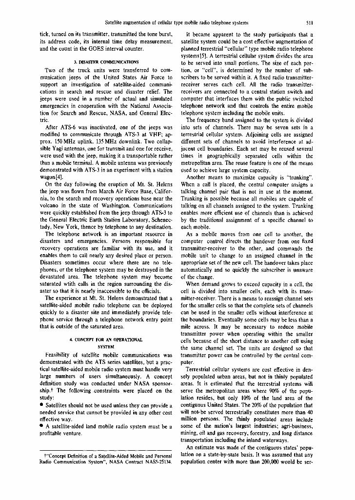
Table 3. Population served by satellite in selected states
AREA
CALIFORNIA 158,693 ILLINOIS 56,400 NASSACHUSEI"rs 8,257 MONTANA 147,1S8 NEBRASKA 77,227 NEVADA 110,540 NEW YORK 49,576
POPULATION POPULATION DENSITY SERVED LESS URBAN PERSONS/MI 2 POPULATION SERVED
POPULATION OVER 200.000 0OTSIDE URBAN FACTOR DENSITY POPULATION
19,953,134 2,265,462 14.3 0.86 12.33 1,948,298 11,113,976 3,158,349 56.0 0 52 29.03 1,642,341 5,689,170 1,960,294 237.0 0 0 0
694,409 694,409 4.72 0.95 4.S 659,688 1,485,791 945,649 12.2 0.88 10.76 830,411
448, 738 175,450 1.59 0.98 1.56 171,941 18,241,266 2,495,024 50.3 0.56 28.18 1,397,213
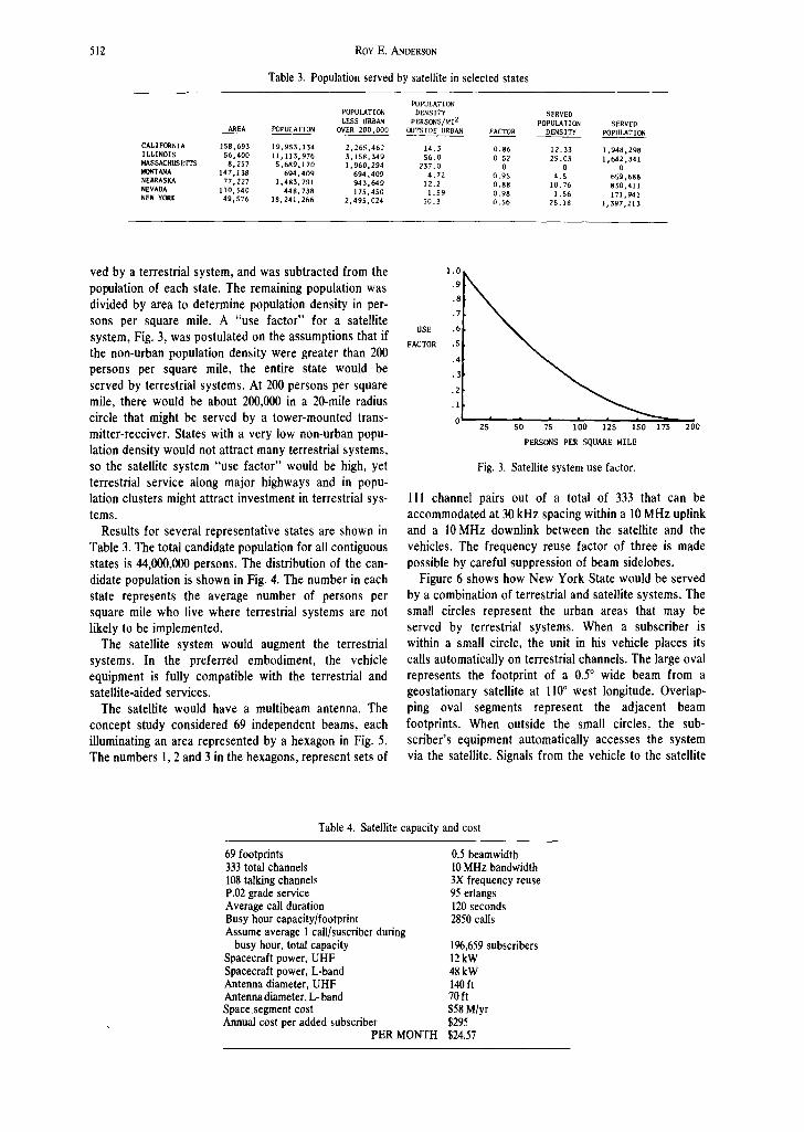
ved by a terrestrial system, and was subtracted from the population of each state. The remaining population was divided by area to determine population density in per- sons per square mile. A "use factor" for a satellite system, Fig. 3, was postulated on the assumptions that if the non-urban population density were greater than 200 persons per square mile, the entire state would be served by terrestrial systems. At 200 persons per square mile, there would be about 200,000 in a 20-mile radius circle that might be served by a tower-mounted trans- mitter-receiver. States with a very low non-urban popu- lation density would not attract many terrestrial systems, so the satellite system "use factor" would be high, yet terrestrial service along major highways and in popu- lation clusters might attract investment in terrestrial sys- tems.
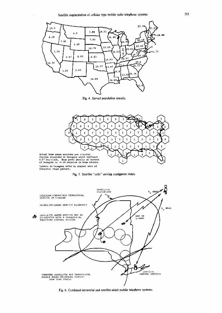
Results for several representative states are shown in Table 3. The total candidate population for all contiguous states is 44,000,000 persons. The distribution of the can- didate population is shown in Fig. 4. The number in each state represents the average number of persons per square mile who live where terrestrial systems are not likely to be implemented.
The satellite system would augment the terrestrial systems. In the preferred embodiment, the vehicle equipment is fully compatible with the terrestrial and satellite-aided services.
The satellite would have a multibeam antenna. The concept study considered 69 independent beams, each illuminating an area represented by a hexagon in Fig. 5. The numbers 1, 2 and 3 in the hexagons, represent sets of
1 . 0
.9
.8
.7
USE .6
FACTOR . S
.4
.2
.2
.1
0 25 SO 75 100 125 150 175 200
PERSONS PER SQUARE MILE
Fig. 3. Satellite system use factor.
I II channel pairs out of a total of 333 that can be accommodated at 30 kHz spacing within a 10 MHz uplink and a 10MHz downlink between the satellite and the vehicles. The frequency reuse factor of three is made possible by careful suppression of beam sidelobes.
Figure 6 shows how New York State would be served by a combination of terrestrial and satellite systems. The small circles represent the urban areas that may be served by terrestrial systems. When a subscriber is within a small circle, the unit in his vehicle places its calls automatically on terrestrial channels. The large oval represents the footprint of a 0.5 ° wide beam from a geostationary satellite at l l0 ° west longitude. Overlap- ping oval segments represent the adjacent beam footprints. When outside the small circles, the sub- scriber's equipment automatically accesses the system via the satellite. Signals from the vehicle to the satellite
Table 4. Satellite capacity and cost
69 footprints 333 total channels 108 talking channels P.02 grade service Average call duration Busy hour capacity/footprint Assume average 1 call/suscriber during
busy hour, total capacity Spacecraft power, UHF Spacecraft power, L-band Antenna diameter, UHF Antenna diameter, L- band Space segment cost Annual cost per added subscriber
PER MONTH
0.5 beamwidth 10 MHz bandwidth 3X frequency reuse 95 erlangs 120 seconds 2850 calls
196,659 subscribers 12 kW 48 kW 140 ft 70 ft $58 M/yr $295 $24.57
<
Satellite augmentation of cellular type mobile radio telephone systems
. ~ ~ I "--'-~ 27.~ ~'~ i0.76~27.05 ~ 0
~ 2 . 7 3
Fig. 4. Served population density.
513
A A
A c t u a l ~ c ~ s s s e c t i o n s are c 2i~r7 ~" ~ i ~ 2 " 2 ~ ~ 3 ~
Circles inscribed in hexagons would represent V ~ 0.S* be&r.width. ~ power density a t c o ~ e r s of hexagons is -4 dB relative to be~ centers.
X ~ b e r s i n h e x a g o n s r e f e r t o c h ~ n e l s e t s o f f r e q u e n c y r e ~ e p a t t e ~ .
Fig. 5. Satellite "cells" serving contiguous states.
CELLULAR-COMPATIBLE TERRESTRIAL SERVICE IN CIRCLES
SATELLITE-AIDED SERVICE ELSEWHE) E
SATELLITE EARTH STATION MAY BE CO-LOCATED WITH A TERRESTRIAL TELEPHONE CENTRAL STATION
SATELLITE FOOTPRINTS K
UHF OR L-BAND
RAND u
COMBINED SATELLITE AND TERRESTRIAL MOBILE RADIO TELEPHONE CONCEPT
(NEW YORK STATE)
SATELLITE ~( CONTROL STATION
Fig. 6. Combined terrestrial and satellite-aided mobile telephone systems.
514 RoY E. ANDERSON
are on UHF (800-900 MHz) or L-band (1550-1650 MHz). They are relayed to a small earth station on some higher frequency, perhaps Ku band (12-14 Hz). The earth sta- tion automatically assigns specific channel pairs within the beam subset for each cell and interconnects the vehicle with the public switched telephone network. Signals from the earth station to the satellite are on Ku band, and are relayed to the vehicle at UHF or L-band.
A summary description of the satellite system is presented in Table 4. The annual cost for the space segment and its operation is estimated to the 60 million dollars.
The costs include two satellites in orbit, a spare on earth, amortization of system development, ground complex and operating costs, insurance, and cost of money. The satellite could assure high quality service to about 200,000 subscribers. The monthly-cost for the space segment is thus about $25 per subscriber that is added to the combined systems.
5. CONCLUSIONS
Satellite-aided mobile communications and position fixing are feasible for all types of vehicles including automobiles.
Mobile radio telephone communications are needed for commercial as well as public services in rural and remote areas. Satellite-aided mobile radio may be a cost effective means to fulfill the needs.
Acknowledgments--Many persons contributed to the activities described in this paper. Major General Electric contributors were James R. Lewis and Richard L. Frey of the Company's Cor- porate Research and Development Center, and Robert T. Milton of the Space Division. Master Sgt. William Kratch of the U.S. Air Force 303rd Air Rescue and Recovery Service configured and operated the special communication jeep that included the satellite communication capabilities. Dr. James P. Brown of NASA served as technical officer on the truck and towboat experiments, and personnel at NASA's ATS Operations Control Center scheduled the use of the satellites.
REFERENCES 1. Burge C. D. Experimental use of mobile satellite com-
munications technology in rural EMS systems. Emergency Medical Services 9, 50-55 (1980).
2. Anderson R. E. Satelliie-aided land mobile radio experiments. applications and problems. Acta Astronautica 7,807-824 (1980).
3. Trucksat--an international transport communication system, Swedish Space Corporation Report (1980).
4. Brisken A. F., Anderson R. E., Frey R. L. and Lewis J. R. Land mobile communications and position fixing using satel- lites, IEEE Transactions on Vehicular Tech. VT-28 (1979).
5. The Bell Syst. Tech. 58 (1979).