Embed Size (px)
Citation preview
Satellite-Derived Cloud and Radiation Retrievals over Various ARM Domains M. M. Khaiyer1, P. Minnis2 (PI), K.M.Bedka2, S.T. Bedka1, F.-L. Chang1, T.L. Chee1, M.L.Nordeen1, R. Palikonda1, B. Scarino1, W.L. Smith, Jr. 2,
D. Spangenberg1, Q.Z Trepte1, C.R. Yost1 1Science Systems and Applications Inc, Hampton, VA 2NASA/Langley Research Center, Hampton, VA
Motivation
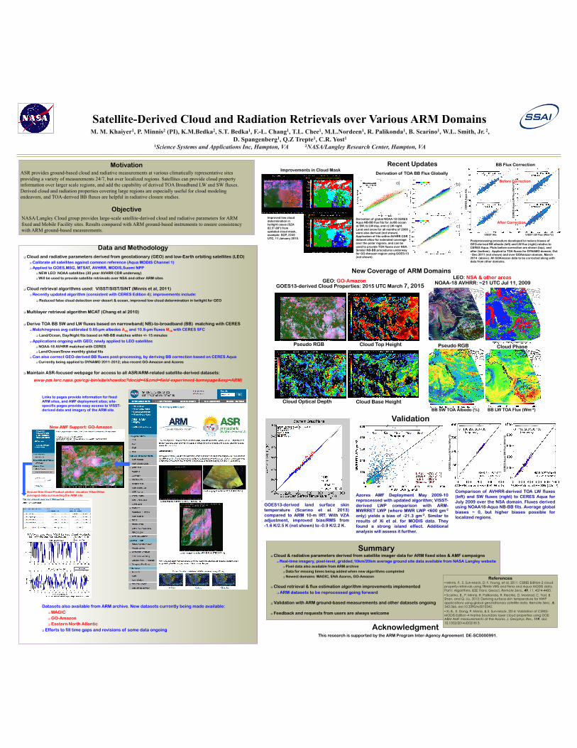
Pseudo RGB
Cloud Base Height
Cloud Top Height
Cloud Optical Depth
GOES13-derived Cloud Properties: 2015 UTC March 7, 2015
New Coverage of ARM Domains
NOAA-18 AVHRR: ~21 UTC Jul 11, 2009
BB LW TOA Flux (Wm-2) BB SW TOA Albedo (%)
GOES13-derived land surface skin temperature (Scarino et al. 2013) compared to ARM 10-m IRT. With VZA adjustment, improved bias/RMS from -1.6 K/2.5 K (not shown) to -0.9 K/2.2 K.
ASR provides ground-based cloud and radiative measurements at various climatically representative sites providing a variety of measurements 24/7, but over localized regions. Satellites can provide cloud property information over larger scale regions, and add the capability of derived TOA Broadband LW and SW fluxes. Derived cloud and radiation properties covering large regions are especially useful for cloud modeling endeavors, and TOA-derived BB fluxes are helpful in radiative closure studies.
Objective NASA/Langley Cloud group provides large-scale satellite-derived cloud and radiative parameters for ARM fixed and Mobile Facility sites. Results compared with ARM ground-based instruments to ensure consistency with ARM ground-based measurements.
Data and Methodology Cloud and radiative parameters derived from geostationary (GEO) and low-Earth orbiting satellites (LEO)
Calibrate all satellites against common reference (Aqua MODIS Channel 1) Applied to GOES,MSG, MTSAT, AVHRR, MODIS,Suomi NPP
NEW LEO: NOAA satellites (30 year AVHRR CDR underway) Will be used to provide satellite retrievals over NSA and other ARM sites
Cloud retrieval algorithms used: VISST/SIST/SINT (Minnis et al, 2011) Recently updated algorithm (consistent with CERES Edition 4); improvements include:
Reduced false cloud detection over desert & ocean, improved low cloud determination in twilight for GEO
Multilayer retrieval algorithm MCAT (Chang et al 2010)
Derive TOA BB SW and LW fluxes based on narrowband( NB)-to-broadband (BB) matching with CERES Match/regress avg calibrated 0.65-µm albedos Anb and 10.8-µm fluxes Mnb with CERES SFC
Land/Ocean, Day/Night fits based on NB-BB matches within +/- 15 minutes
Applications ongoing with GEO; newly applied to LEO satellites NOAA-18 AVHRR matched with CERES Land/Ocean/Snow monthly global fits
Can also correct GEO-derived BB fluxes post-processing, by deriving BB correction based on CERES Aqua Currently being applied to DYNAMO 2011-2012; also recent GO-Amazon and Azores
Maintain ASR-focused webpage for access to all ASR/ARM-related satellite-derived datasets:
www-pm.larc.nasa.gov/cgi-bin/site/showdoc?docid=4&cmd=field-experiment-homepage&exp=ARM)
GEO: GO-Amazon LEO: NSA & other areas
Validation
Recent Updates
Azores AMF Deployment May 2009-10 reprocessed with updated algorithm; VISST-derived LWP comparison with ARM-MWRRET LWP (where MWR LWP <600 gm-2 only) yields a bias of -21.3 gm-2. Similar to results of Xi et al. for MODIS data. They found a strong island effect. Additional analysis will assess it further.
Summary
Datasets also available from ARM archive. New datasets currently being made available: MAGIC GO-Amazon Eastern North Atlantic
Efforts to fill time gaps and revisions of some data ongoing
New AMF Support: GO-Amazon
Links to pages provide information for fixed ARM sites, and AMF deployment sites; site-specific pages provide easy access to VISST-derived data and imagery of the ARM site.
Improvements in Cloud Mask
Missing low clouds in twilight
Low clouds correctly detected in new cloud mask Improved low cloud determination in twilight cases (SZA 82.5°-88°) from updated cloud mask, example: SGP, 2245 UTC, 11 January 2015.
Ground Site Cloud Product plotter: visualize 10km/20km averaged data surrounding the ARM site.
Acknowledgment
Derivation of TOA BB Flux Globally
a) b)
c)
BB Flux Correction
Comparison of AVHRR-derived TOA LW fluxes (left) and SW fluxes (right) to CERES Aqua for July 2009 over the NSA domain. Fluxes derived using NOAA18-Aqua NB-BB fits. Average global biases ~ 0, but higher biases possible for localized regions.
Postprocessing procedure developed to reduce biases of GEO-derived BB albedo (left) and LW flux (right) relative to CERES Aqua. Plots before correction are shown (top), and after (bottom). Applied to TOA fluxes for DYNAMO domain, Oct - Dec 2011 (not shown) and over GOAmazon domain, March 2014 (above). All GOAmazon data to be corrected along with data from other domains.
Cloud & radiative parameters derived from satellite imager data for ARM fixed sites & AMF campaigns Real-time imagery, pixel-level, gridded,10km/20km average ground site data available from NASA Langley website
Pixel data also available from ARM archive Data for missing times being added when new algorithms completed Newest domains: MAGIC, ENA Azores, GO-Amazon
Cloud retrieval & flux estimation algorithm improvements implemented ARM datasets to be reprocessed going forward
Validation with ARM ground-based measurements and other datasets ongoing
Feedback and requests from users are always welcome
This research is supported by the ARM Program Inter-Agency Agreement DE-SC0000991.
References • Minnis, P., S. Sun-Mack, D. F. Young, et al, 2011: CERES Edition-2 cloud property retrievals using TRMM VIRS and Terra and Aqua MODIS data, Part I: Algorithms. IEEE Trans. Geosci. Remote Sens., 49, 11, 4374-4400. • Scarino, B., P. Minnis, R. Palikonda, R. Riechle, D. Morstad, C. Yost, B. Shan, and Q. Liu, 2013: Deriving surface skin temperature for NWP applications using global geostationary satellite data. Remote Sens., 5, 342-366, doi:10.3390/rs5010342. • Xi, B., X. Dong, P. Minnis, & S. Sun-Mack, 2014: Validation of CERES-MODIS Edition 4 marine boundary layer cloud properties using DOE ARM AMF measurements at the Azores. J. Geophys. Res., 119, doi:10.1002/2014JD021813.
Derivation of global NOAA-18 CERES Aqua NB-BB flux fits for Jul08 ocean a) SW, b) LW day, and c) LW night. Land and snow for all months of 2008 were also derived (not shown). Application of fits within AVHRR CDR dataset allow for extended coverage over the polar regions, and can be used to provide TOA fluxes over NSA. Similar NB-BB procedures underway for GO-Amazon region using GOES-13 (not shown).
CE
RE
S A
qu
a A
lb
CE
RE
S A
qu
a L
W F
lux
(W/m
^2
)
VISST LW Flux (W/m^2) VISST Alb
CE
RE
S A
qu
a L
W F
lux
(W/m
^2
)
CE
RE
S A
qu
a S
W F
lux
(W/m
^2
)
Before Correction
After Correction
Pseudo RGB Cloud Phase