Embed Size (px)
Citation preview
IAIN World Congress 2015
21 – 23 October, Prague, Czech Republic
Sharafat Gadimova
Office for Outer Space Affairs
ICG Executive Secretariat
Satellite Navigation and its Future
Perspectives, International Aspects
United Nations Office for Outer Space Affairs: Mandate
The Office implements the decisions of the General Assembly and of the United Nations Committee on the Peaceful Uses of Outer Space (COPUOS);
Performs functions of substantive Secretariat of the Committee on the Peaceful Uses of Outer Space and its Scientific & Technical Subcommittee and Legal Subcommittee;
Coordinates the inter-agency cooperation within the United Nations on the use of space technology (UN-SPACE);
Maintains coordination and cooperation with space agencies and intergovernmental and non-governmental organizations involved in space-related activities;
Implements the United Nations Programme on Space Applications;
Serves as Executive Secretariat for the International Committee on Global Navigation Satellite Systems (ICG)

International Committee on GNSS (ICG): Mission Statement
Promote voluntary cooperation on matters of mutual interest related to civil satellite-based positioning, navigation, timing, and value added services
Contribute to the sustainable development of the world
Encourage coordination among GNSS Providers to ensure greater compatibility, interoperability, and transparency
Promote the introduction and utilization of GNSS services in developing countries, by assisting with the integration into their infrastructure
Assist GNSS users with their development plans and applications, by encouraging coordination and serving as a focal point for international information exchange
ICG-8 Meeting, 2013, Dubai, United Arab Emirates
Background
2001 – 2004: Action Team on GNSS (Italy and United States)
38 member States and 15 international and non-governmental organizations;
Comprehensive review of existing and planned GNSS and augmentations, their applications by system providers and user communities;
Examined the requirements of developing countries and gaps in meeting those requirements, including education and training opportunities in the field of GNSS
2005: Establishment of the ICG (noted by UNGA 61/111 of 14 December 2006)
Promote the use of GNSS and its integration into infrastructure, particularly in developing countries;
Encourage compatibility and interoperability among global and regional systems
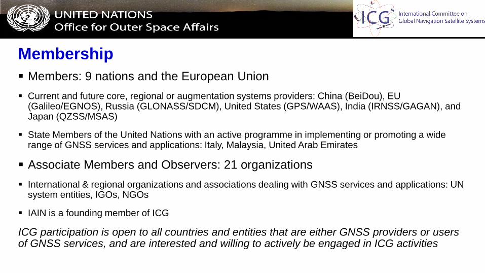
Membership
Members: 9 nations and the European Union
Current and future core, regional or augmentation systems providers: China (BeiDou), EU (Galileo/EGNOS), Russia (GLONASS/SDCM), United States (GPS/WAAS), India (IRNSS/GAGAN), and Japan (QZSS/MSAS)
State Members of the United Nations with an active programme in implementing or promoting a wide range of GNSS services and applications: Italy, Malaysia, United Arab Emirates
Associate Members and Observers: 21 organizations
International & regional organizations and associations dealing with GNSS services and applications: UN system entities, IGOs, NGOs
IAIN is a founding member of ICG
ICG participation is open to all countries and entities that are either GNSS providers or users of GNSS services, and are interested and willing to actively be engaged in ICG activities
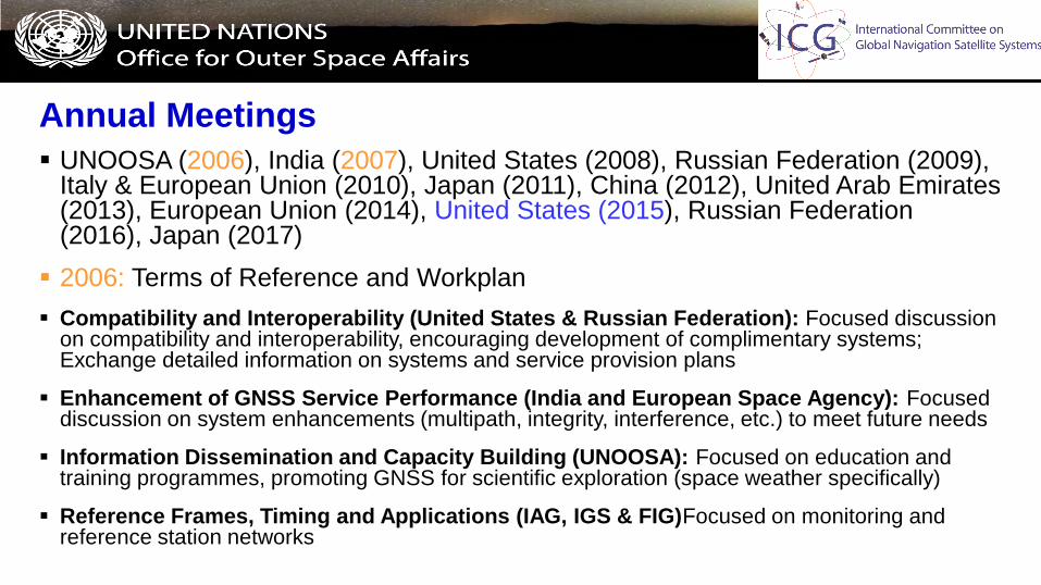
Annual Meetings
UNOOSA (2006), India (2007), United States (2008), Russian Federation (2009), Italy & European Union (2010), Japan (2011), China (2012), United Arab Emirates (2013), European Union (2014), United States (2015), Russian Federation (2016), Japan (2017)
2006: Terms of Reference and Workplan
Compatibility and Interoperability (United States & Russian Federation): Focused discussion on compatibility and interoperability, encouraging development of complimentary systems; Exchange detailed information on systems and service provision plans
Enhancement of GNSS Service Performance (India and European Space Agency): Focused discussion on system enhancements (multipath, integrity, interference, etc.) to meet future needs
Information Dissemination and Capacity Building (UNOOSA): Focused on education and training programmes, promoting GNSS for scientific exploration (space weather specifically)
Reference Frames, Timing and Applications (IAG, IGS & FIG)Focused on monitoring and reference station networks
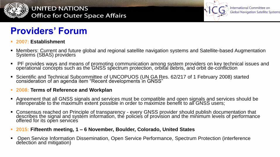
Providers’ Forum 2007: Establishment
Members: Current and future global and regional satellite navigation systems and Satellite-based Augmentation Systems (SBAS) providers
PF provides ways and means of promoting communication among system providers on key technical issues and operational concepts such as the GNSS spectrum protection, orbital debris, and orbit de-confliction
Scientific and Technical Subcommittee of UNCOPUOS (UN GA Res. 62/217 of 1 February 2008) started consideration of an agenda item “Recent developments in GNSS”
2008: Terms of Reference and Workplan
Agreement that all GNSS signals and services must be compatible and open signals and services should be interoperable to the maximum extent possible in order to maximize benefit to all GNSS users;
Consensus reached on Principle of transparency - every GNSS provider should publish documentation that describes the signal and system information, the policies of provision and the minimum levels of performance offered for its open services
2015: Fifteenth meeting, 1 – 6 November, Boulder, Colorado, United States
Open Service Information Dissemination, Open Service Performance, Spectrum Protection (interference detection and mitigation)

Providers’ Forum: Interoperability and Compatibility
The Providers’ Forum continues to investigate the benefits of carrier frequency commonality and diversity, as well as of compatibility and interoperability, as these latter terms are defined bellow:
Compatibility (“do no harm”) refers to the ability of global and regional navigation satellite systems and augmentations to be used separately or together without causing unacceptable interference and/or other harm to an individual system and/or service
Interoperability (“better together than separate”) refers to the ability of global and regional navigation satellite systems and augmentations and the services they provide to be used together to provide better capabilities at the user level than would be achieved by relying solely on the open signals of one system.
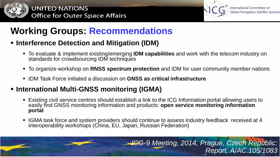
Working Groups: Recommendations
Interference Detection and Mitigation (IDM)
To evaluate & implement existing/emerging IDM capabilities and work with the telecom industry on standards for crowdsourcing IDM techniques
To organize workshop on RNSS spectrum protection and IDM for user community member nations
IDM Task Force initiated a discussion on GNSS as critical infrastructure
International Multi-GNSS monitoring (IGMA)
Existing civil service centres should establish a link to the ICG Information portal allowing users to easily find GNSS monitoring information and products: open service monitoring information portal
IGMA task force and system providers should continue to assess industry feedback received at 4 interoperability workshops (China, EU, Japan, Russian Federation)
ICG-9 Meeting, 2014, Prague, Czech Republic: Report, A/AC.105/1083
ICG Working Groups: Recommendations
Interoperable GNSS Service Volume (SSV) Characterization Outreach
Providers should develop a booklet defining the characteristics of a fully interoperable space service volume
NeQuick Ionospheric Model
To assess the performance and usability of a NeQuick ionospheric correction algorithm for the single frequency users similar to the one adopted by Galileo in view of its expected good performance compared with other models, i.e. at low latitudes: http://www.gsc-europa.eu/system/files/galileo_documents/Galileo_Ionospheric_Model.pdf
Market Access
Providers will continue discussing the topic of fair “ Market Access”
ICG-9 Meeting, 2014, Prague, Czech Republic: Report, A/AC.105/1083
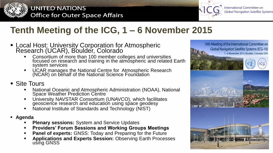
Tenth Meeting of the ICG, 1 – 6 November 2015
Local Host: University Corporation for Atmospheric Research (UCAR), Boulder, Colorado
Consortium of more than 100 member colleges and universities focused on research and training in the atmospheric and related Earth system services
UCAR manages the National Centre for Atmospheric Research (NCAR) on behalf of the National Science Foundation
Site Tours National Oceanic and Atmospheric Administration (NOAA), National
Space Weather Prediction Centre University NAVSTAR Consortium (UNAVCO), which facilitates
geoscience research and education using space geodesy National Institute of Standards and Technology (NIST)
Agenda Plenary sessions: System and Service Updates Providers’ Forum Sessions and Working Groups Meetings Panel of experts: GNSS: Today and Preparing for the Future Applications and Experts Session: Observing Earth Processes
using GNSS
Programme on GNSS applications
United Nations Regional Workshops/training courses on the use and applications of GNSS
These activities increase awareness among decision and policy makers of the benefits of GNSS, and develop regional and national pilot projects on GNSS applications
These activities bring together a large number of experts, including those from developing countries, to discuss and act on issues that are also of high relevance to the ICG
United Nations/Russian Federation Workshop, May 2015, Krasnoyarsk
ICG Experts Meeting: GNSS Services, 14 – 18 December 2015, Vienna
To focus on identifying the needs of users with respect to the compatibility and interoperability of global and regional systems, and space-based augmentations providing and planning to provide GNSS service
To incorporate useful user and application sector views and inputs into the Working Groups work plans
Seminar on GNSS Spectrum Protection and IDM
Programme on GNSS applications
Promoting the use of GNSS technologies as tools for scientific applications
These activities are to provide technical knowledge on the operational and practical aspects and issues relating to reference frames, in particular to facilitate a regional forum for geodetic agencies, improve data sharing (GNSS leveling, tide gauge, gravity)
Technical Seminars on Reference Frames in Practice, FIG Working Week 2016, Christchurch, New Zealand
Space Weather and its effects on GNSS
ICTP and Boston College: Workshops on Ionospheric Effects on SBAS and GBAS Applications at Low Latitudes
United Nations/Italy Long-term Fellowship Programme: Master in Navigation and Related Applications (MNA), Politecnico di Torino, Turin, Italy
The curriculum is structured to meet effectively work market demands for high-level technicians endowed with a broad vision of the navigation/localization sate-of-the-art
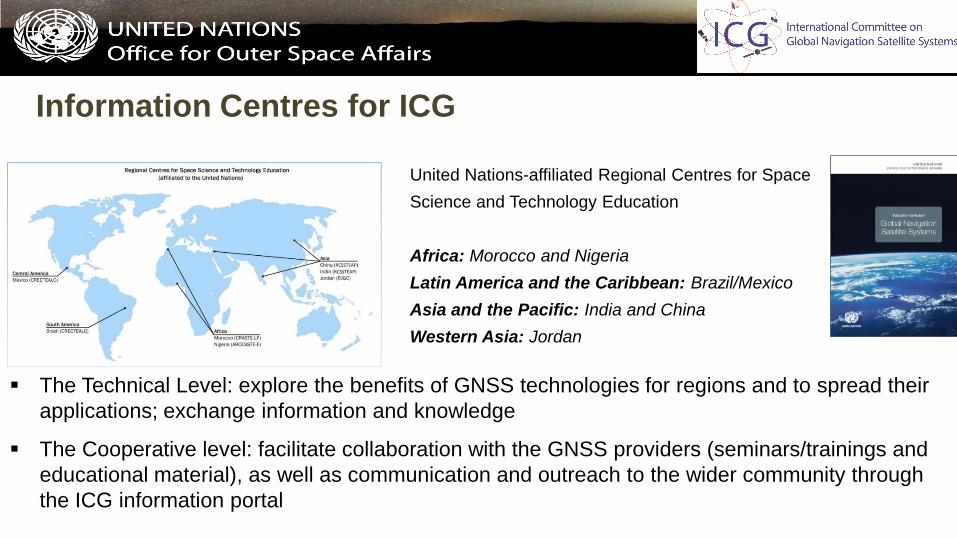
Information Centres for ICG
United Nations-affiliated Regional Centres for Space
Science and Technology Education
Africa: Morocco and Nigeria
Latin America and the Caribbean: Brazil/Mexico
Asia and the Pacific: India and China
Western Asia: Jordan
The Technical Level: explore the benefits of GNSS technologies for regions and to spread their
applications; exchange information and knowledge
The Cooperative level: facilitate collaboration with the GNSS providers (seminars/trainings and
educational material), as well as communication and outreach to the wider community through
the ICG information portal

ICG Information Portal
WWW.UNOOSA.ORG
WWW.UNOOSA.ORG/OOSA/EN/OURWORK/ICG/ICG.HTML
2010: Report on planned
and existing global
navigation satellite
systems and their policies
and procedures
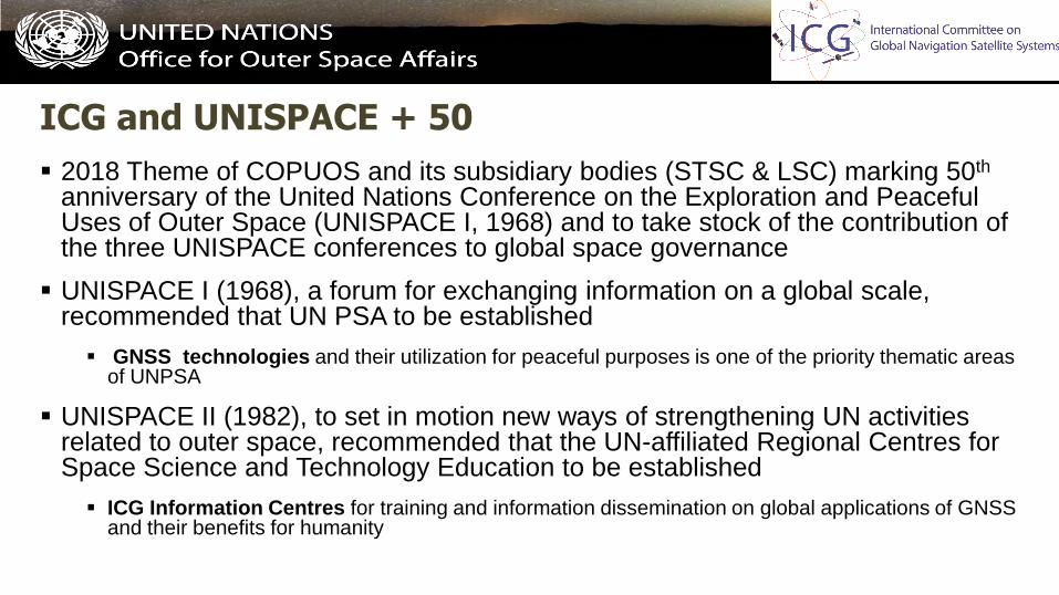
ICG and UNISPACE + 50
2018 Theme of COPUOS and its subsidiary bodies (STSC & LSC) marking 50th anniversary of the United Nations Conference on the Exploration and Peaceful Uses of Outer Space (UNISPACE I, 1968) and to take stock of the contribution of the three UNISPACE conferences to global space governance
UNISPACE I (1968), a forum for exchanging information on a global scale, recommended that UN PSA to be established
GNSS technologies and their utilization for peaceful purposes is one of the priority thematic areas of UNPSA
UNISPACE II (1982), to set in motion new ways of strengthening UN activities related to outer space, recommended that the UN-affiliated Regional Centres for Space Science and Technology Education to be established
ICG Information Centres for training and information dissemination on global applications of GNSS and their benefits for humanity

ICG and UNISPACE + 50
UNISPACE III (1999), the Vienna Declaration put forth 33 recommendations
Recommendation on GNSS: “…to improve the efficiency and security of transport, search and rescue, geodesy and other activity by promoting the enhancement of, universal access to and compatibility of space-based navigation and positioning systems”
The work of ICG is growing rapidly in line with anticipation that GNSS applications will continue to grow in the coming years
Leading towards 2018, High Level Forum: Space as a Driver for Socio-Economic Sustainable Development (2016 – 2018)
To facilitate constructive dialogue between policy-makers and key stakeholders from different parts of government, civil society, business and industry, to address the broader perspective of space economy, space society, space accessibility and space diplomacy
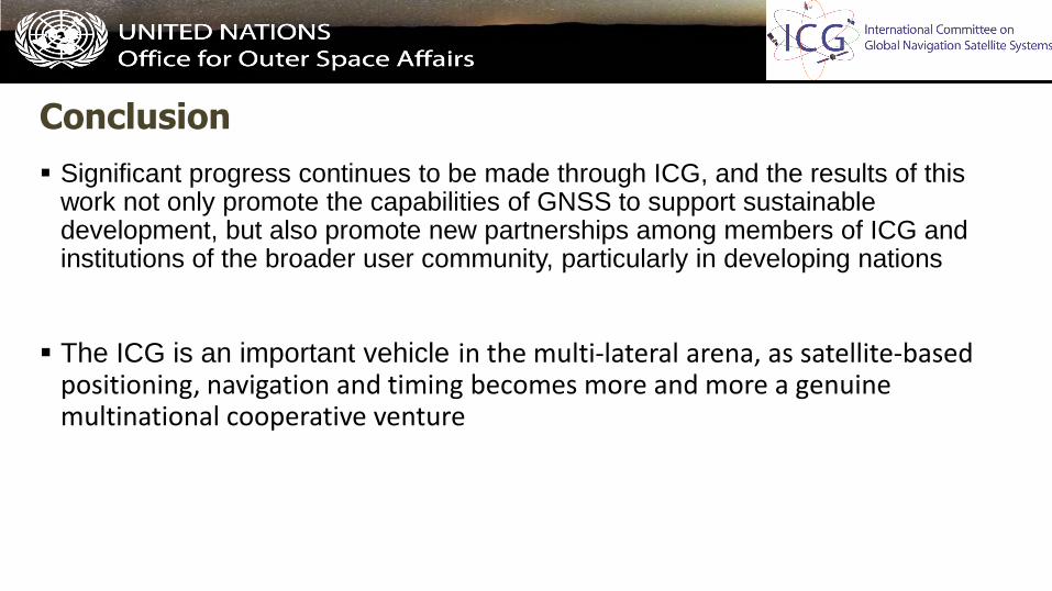
Conclusion
Significant progress continues to be made through ICG, and the results of this work not only promote the capabilities of GNSS to support sustainable development, but also promote new partnerships among members of ICG and institutions of the broader user community, particularly in developing nations
The ICG is an important vehicle in the multi-lateral arena, as satellite-based positioning, navigation and timing becomes more and more a genuine multinational cooperative venture


![Convergence of Wachspress coordinates: from polygons to ...jiri/papers/14KoBa.pdf · convex polygons are Wachspress coordinates [14], mean value coordinates [4], and harmonic coordinates](https://img.pdfslide.net/doc/110x75/5f6dfe23261f61015179236e/convergence-of-wachspress-coordinates-from-polygons-to-jiripapers-convex.jpg)