Embed Size (px)
Citation preview

Satellite Positioning
Matthieu Lonchay
Performances under Ionospheric Scintillations
Geomatics Unit
Thesis Committee
June 11, 2013
Geomatics Unit, ULg
University of Liège, Belgium
F.R.S.-FNRS, Belgium


Introduction
Research
Perspectives
Objectives
Conclusions

The Ionosphere is Ionized by Solar Radiation
UV
X-RaysMeV protons
CME’s
Solar Winds
Solar Flares
Introduction – Ionosphere

�� � �� � 1 � 40.3
� ����
�
�
� � � 40.3 � � �� ��
�
�� � 40.3
� ����
GNSS Signals are refracted by the Ionosphere
Introduction – Ionosphere

�� � �� � 1 � 40.3
� ��
�
��
� � � 40.3 � � �� ��
�
�� � 40.3
� ����
��
��
����
��
GNSS Signals are refracted by the Ionosphere
Introduction – Ionosphere

��
Ionospheric Electron Density
Irregularities
Spatial Variation of the
Refraction Index
Signal Losses
Signal Diffraction
Constructive and Destructive
Signal Interferences
~
GNSS Signals are diffracted by the Ionosphere
Introduction – Ionosphere

Ionospheric Electron Density
Diffraction Pattern
Received Signal Intensity
�!
�!
"
GNSS Signals are diffracted by the Ionosphere
Introduction – Ionosphere

UV
X-Rays
MeV protons
CME’s
Solar Winds
Solar Flares #$� %��&� �$�'$"'(� )&�"�
Ionospheric Electron Density Irregularities are
involved by Geomagnetic Storms
Introduction – Ionosphere

Geomagnetic Storms can be detected
by global Geomagnetic Indices
Halloween Storm
300/03 27-Oct-2003
2
4
6
8
KP
0
100
200
300
400
AP
-500
-400
-300
-200
-100
0
100
DST [nT]
00h 03h 06h 09h 12h 15h 18h 21h 24h
Introduction – Ionosphere

Geomagnetic Storms can be detected
by global Geomagnetic Indices
Halloween Storm
302/03 29-Oct-2003
2
4
6
8
KP
0
100
200
300
400
AP
-500
-400
-300
-200
-100
0
100
DST [nT]
00h 03h 06h 09h 12h 15h 18h 21h 24h
Introduction – Ionosphere

Ionospheric Electron Density Irregularities involve
GNSS Signal Phase and Amplitude fluctuations
Brussels - Simulation
001/11 01-Jan-2011
N
E
S
W
0°
30°
60°
15
30
45
60
75
Elevation [°]
-15
0
15
WLNL [m]
40
45
50
S1C [dB Hz]
06h 09h 12h 15h
Introduction – Ionosphere

Ionospheric Scintillation Effects on GNSS Signals
are Monitored by Scintillation GNSS Receivers
Low Data Rate (≈ 0.01 - 1 Hz)
Positioning
RINEX Files
Classic Observables
- C1C- L1C- D1C- S1C- …
High Data Rate (≈ 50-100 Hz)
ISMR Files
Space Weather
Specific Observables
- S4- Phi60- …
*+ � �� , � ��
-. � /� , / �
Ionospheric Scintillation Monitoring Receiver - ISMR
Introduction – Ionosphere

Ionospheric Scintillations exhibit
Spatial and Temporal Characteristics
FrequentInfrequent
Operating Frequencies
Geographic Locations
Local Time
Season
Magnetic Activity
Solar Activity
Introduction – Ionosphere

Ionospheric Scintillations exhibit
Spatial and Temporal Characteristics
FrequentInfrequent
Large Scale Irregularities
≈ 100 km
Small Scale Irregularities
≈ 1 – 100 m
Background Plasma Drift Speed
≈ 50-150 ms-1
Duration
≈ minutes/hours
Spatiotemporal Variations of
Scintillations Intensity
Introduction – Ionosphere
Satellite Positioning is based on Multilateration
��� t � 1�� 2 ��� 2 ��,4,5� 2 c ∆"� , ∆"� 2 8�,4,5� 2 9�,4,5�
:�� t � 1�� 2 ��� , ��,4,;� 2 c ∆"� , ∆"� 2 <4��,4� 2 8�,4,;� 2 9�,4,;�
��,4� � 40.3 � ����
sTEC
1�� � =>� , >�?�2=@� , @�?�2=�� , ��?�
9�,4,5�
��,4�
9�,4,;��
�
Introduction – Positioning

The Standard Point Positioning is an elementary SF Technique
��� t � 1�� 2 ��� 2 ��,4,5� 2 c ∆"� , ∆"� 2 8�,4,5� 2 9�,4,5�
Pseudorange (code) measurements
Single Point Single Epoch (SPSE) Technique
Atmospheric Models (Ionosphere and Troposphere)
Broadcast Ephemeris
1�� � =>� , >�?�2=@� , @�?�2=�� , ��?�
Real-Time / Post-Processing
Static / Kinematic
�
�
Least Square Adjustement (LSA) to resolve unknowns
Single Frequency
Introduction – Positioning

The Standard Point Positioning is an elementary SF Technique
Brussels
001/12 01-Jan-2012
0
5
10
15
Error [m]
-10
-5
0
5
10
Error [m]
North
East
Up
3D Error
00h 03h 06h 09h 12h 15h 18h 21h 24h
Introduction – Positioning

��� t � 1�� 2 ��� 2 ��,4,5� 2 c ∆"� , ∆"� 2 8�,4,5� 2 9�,4,5�
�
�
:�� t � 1�� 2 ��� , ��,4,;� 2 c ∆"� , ∆"� 2 <4��,4� 2 8�,4,;� 2 9�,4,;�
Pseudorange (code) and Carrier-Phase measurements
Dual Frequency
Strategies against atmospheric effects
Precise Products: Ephemeris / Code-Phase Delays / Antenna
Real-Time / Post-Processing
Static / Kinematic
Sequential Least Squares Adjustment (Filter)
Ambiguity Resolution Process
The Precise Point Positioning is an advanced DF Technique
Introduction – Positioning

��� t � 1�� 2 ��� 2 ��,4,5� 2 c ∆"� , ∆"� 2 8�,4,5� 2 9�,4,5�
�
�
:�� t � 1�� 2 ��� , ��,4,;� 2 c ∆"� , ∆"� 2 <4��,4� 2 8�,4,;� 2 9�,4,;�
��,�A� t � 1�� 2 ��� 2 c ∆"� , ∆"� 2 8�,�A,5� 2 9�,�A,5�
:�,�A� t � 1�� 2 ��� 2 c ∆"� , ∆"� 2 <�A��,�A� 2 8�,�A,;� 2 9�,�A,;�
Mathematical Model: Ionosphere-Free + Precise Products
Solution: Sequential Least Square Adjustment (Filter)
Stochastic Model
The Precise Point Positioning is an advanced DF Technique
Introduction – Positioning

The Precise Point Positioning is an advanced DF Technique
Brussels
001/12 01-Jan-2012
0
0.5
1
1.5
2
2.5
3
Error [m]
-2
-1
0
1
2
3
Error [m]
North
East
Up
3D Error
00h 03h 06h 09h 12h 15h 18h 21h 24h
Introduction – Positioning

The Precise Point Positioning is highly sensitive to
Ionospheric Scintillations Effects
Brussels
069/12 09-Mar-2012
0
5
10
15
20
Error [m]
-15
-10
-5
0
5
10
15
Error [m]
North
East
Up
3D Error
00h 03h 06h 09h 12h 15h 18h 21h 24h
Introduction – Positioning

Brussels
069/12 09-Mar-2012
2
4
6
8
KP
-15
-10
-5
0
5
10
15
Error [m]
North
East
Up
00h 03h 06h 09h 12h 15h 18h 21h 24h
Introduction – Positioning
The Precise Point Positioning is highly sensitive to
Ionospheric Scintillations Effects

Introduction
Research
Perspectives
Objectives
Conclusions

Objectives
The Project aims to develop new Strategies to mitigate the
impact of Ionospheric Scintillations on Satellite Positioning
Softwares
Analysis
Stochasticity
Geometry
Preprocessing
Development of Scintillation Analysis Tools
Adaptation of existing softwares

Objectives
The Project aims to develop new Strategies to mitigate the
impact of Ionospheric Scintillations on Satellite Positioning
Softwares
Analysis
Stochasticity
Geometry
Preprocessing
Statistical Analysis of Scintillation Effects
Symptomatic Analysis of Scintillation Effects

Objectives
The Project aims to develop new Strategies to mitigate the
impact of Ionospheric Scintillations on Satellite Positioning
Softwares
Analysis
Stochasticity
Geometry
Preprocessing
Stochastic Model Improvement
Spatial/Empirical Approach
Correlations Assessment between Observables
Correlations Assessment between Satellites
Validation on SPP and PPP
Validation on different Scintillations Types
- Equatorial and Polar Scintillations
- Weak/Moderate/Intense Scintillations

Objectives
The Project aims to develop new Strategies to mitigate the
impact of Ionospheric Scintillations on Satellite Positioning
Softwares
Analysis
Stochasticity
Geometry
Preprocessing
Analysis of Geometric Effects of Scintillations

Objectives
The Project aims to develop new Strategies to mitigate the
impact of Ionospheric Scintillations on Satellite Positioning
Softwares
Analysis
Stochasticity
Geometry
Preprocessing Validation of a Cycle Slips Treatment Method

Introduction
Research
Perspectives
Objectives
Conclusions

Introduction
Research
Perspectives
Objectives
Conclusions Softwares
Analysis
Stochasticity
Geometry
Preprocessing

ESA/gAGE (UPC)
GNSS Data Processing Tool
GNSS Data Analysis Tool
Support
Multipurpose
ScientificProfessionalEducational
gLAB is a SPP and PPP Software for Scientific Purposes
Research – Softwares

Data Downloading
SPP and PPP Processing – Parameters?
Data Files Reading
Specific Treatments
Results Visualisations
Graphic Tools: IPP Maps and Skyplots
gLAB can be coupled with a Matlab Environment Programming
Research – Softwares
287/12 13-Oct-2012
W
00.20.40.60.8
1
Phi60 [rad]
1530456075
Elevation [°]
-15
0
15WLNL [m]
40
45
50S1C [dB Hz]
06h 09h 12h 15h

Introduction
Research
Perspectives
Objectives
Conclusions Softwares
Analysis
Stochasticity
Geometry
Preprocessing
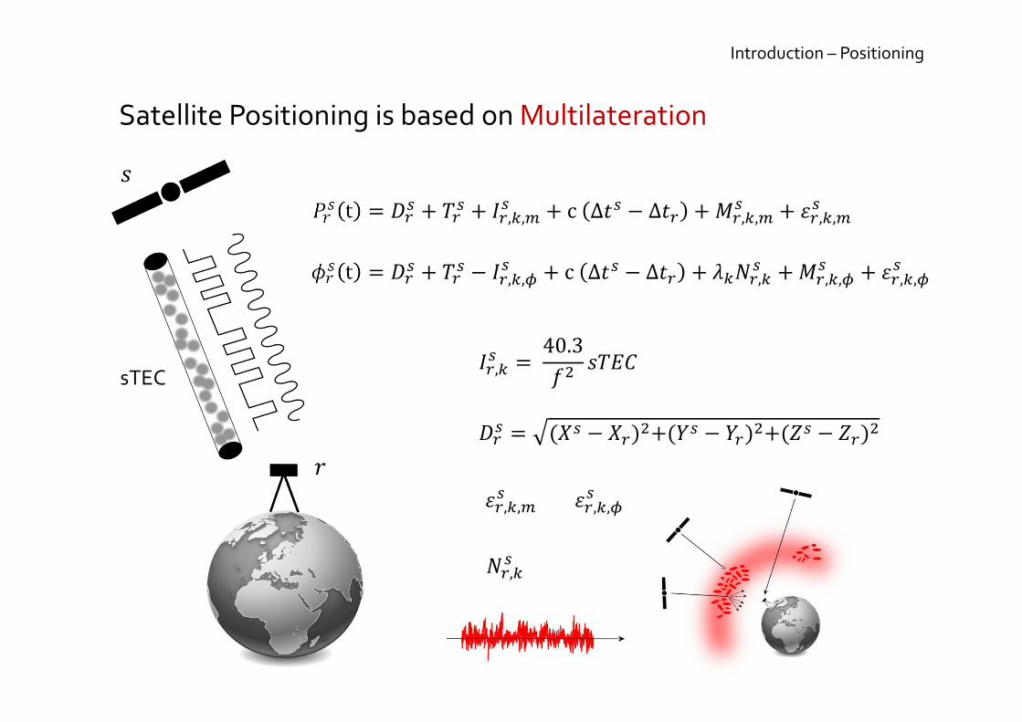
15 ° W
0 ° 15° E
30° E
45° E
30 ° N
45 ° N
60 ° N
75 ° N
BRON
CYPR
LERW
NOTT
TRON
DOUR
ROME
BATH
NCTL
± 2010
± 2011
± 2012
Ionospheric Scintillation Monitoring Receivers (ISMR) Network
Septentrio and Novatel ISMR
RINEX 30”
ISMR 60”
Results – Analysis

1940 1950 1960 1970 1980 1990 2000 2010
Year
0
100
200
300
400International Sunspot Number
0
100
200
300 Daily Mean AP Index
Results – Analysis
Severe Geomagnetic Storms occur under High Solar Activity

2012 2013
Year
0
100
200
300
400
International Sunspot Number
0
100
200
300 Daily Mean AP Index
Daily Max AP Index
Results – Analysis
Brønnøysund
Geomagnetic Storms still occur under Moderate Solar Activity

2012 2013
Year
0
1
2
3
4
5
6
Daily Max S4
Daily Max Phi60 [rad]
0
100
200
300 Daily Mean AP Index
Daily Max AP Index
Results – Analysis
Brønnøysund
Ionospheric Scintillations occur under Moderate Solar Activity

The Analysis Strategy is based on the Selection of 5 typical Days
KP Index
2468
28-Sep-2012
272/12
2468
15-Dec-2012
350/12
2468
09-Mai-2012
130/12
2468
13-Oct-2012
287/12
2468
03-Jun-2012
155/12
00h 03h 06h 09h 12h 15h 18h 21h 24h
Results – Analysis

Results – Analysis
Single Station
Approach
Occurrence: Measurements and Epochs
The Analysis Strategy is based on specific Criteria
Multi Station
ApproachPositioning: SPP and PPP
Geometry: Satellite Number and Dilution of Precision
Spatial Characteristics
Cycle Slips
Noise Measurement
Low/High Magnetic Activity
Medium/High
Latitude

Results – Analysis
Ionospheric Scintillations affect
a very Small Portion of the Measurements
Brønnøysund
Year 2012
97%
3%
S4
< 0.25
> 0.25
92%
7%< 1%
[ 0.25 - 0.4 [
[ 0.4 - 0.55 [
[ 0.55 - ... [
100%
< 1%
Phi60
65%
19%
16%

Brønnøysund
Year 2012
52%48%
S4
< 0.25
> 0.25
73%
22%
4%
[ 0.25 - 0.4 [
[ 0.4 - 0.55 [
[ 0.55 - ... [
97%
3%
Phi60
58%
21%
21%
Results – Analysis
Ionospheric Scintillations affect
a Significant Portion of the Observation Epochs

Brønnøysund
350/12 15-Dec-2012
55%
45%
S4
< 0.25
> 0.25
75%
21%
4%
[ 0.25 - 0.4 [
[ 0.4 - 0.55 [
[ 0.55 - ... [
100%
< 1%
Phi60
50% 50%
Results – Analysis
Ionospheric Scintillations affect
a Significant Portion of the Observation Epochs

Brønnøysund
350/12 15-Dec-2012
0123456789
KP
00h 03h 06h 09h 12h 15h 18h 21h 24h
0.00
0.20
0.40
0.60
0.80
1.00
S4
Mean S4 Max S4
0.00
0.20
0.40
0.60
0.80
1.00
Phi60
Mean Phi60 Max Phi60
Results – Analysis
Ionospheric Scintillations affect
a Significant Portion of the Observation Epochs

Brønnøysund
287/12 13-Oct-2012
51%49%
S4
< 0.25
> 0.25
72%
23%
5%
[ 0.25 - 0.4 [
[ 0.4 - 0.55 [
[ 0.55 - ... [
73%
27%
Phi60
68%
16%
16%
55%
45%
100%
< 1%
50% 50%
75%
21%
4%
Results – Analysis
Ionospheric Scintillations affect
a Significant Portion of the Observation Epochs

Brønnøysund
287/12 13-Oct-2012
0123456789
KP
00h 03h 06h 09h 12h 15h 18h 21h 24h
0.00
0.20
0.40
0.60
0.80
1.00
S4
Mean S4 Max S4
0.00
0.20
0.40
0.60
0.80
1.00
Phi60
Mean Phi60 Max Phi60
Results – Analysis
Ionospheric Scintillations affect
a Significant Portion of the Observation Epochs

Results – Analysis
Single Station
Approach
Occurrence: Measurements and Epochs
The Analysis Strategy is based on specific Criteria
Multi Station
ApproachPositioning: SPP and PPP
Geometry: Satellite Number and Dilution of Precision
Spatial Characteristics
Cycle Slips
Noise Measurement
Low/High Magnetic Activity
Medium/High
Latitude

SPP and PPP Techniques are affected differently
by Ionospheric Scintillations Effects
Brønnøysund
350/12 15-Dec-2012
2
4
6
8
KP
-10
-5
0
5
10
SPP [m]
-2
-1
0
1
2
PPP [m]
North
East
Up
00h 03h 06h 09h 12h 15h 18h 21h 24h
Results – Analysis

Brønnøysund
350/12 15-Dec-2012
-5 -4 -3 -2 -1 0 1 2 3 4 5
East [m]
SPP
-5
-4
-3
-2
-1
0
1
2
3
4
5
North [m]
-5 -4 -3 -2 -1 0 1 2 3 4 5
East [m]
PPP
Results – Analysis
SPP and PPP Techniques are affected differently
by Ionospheric Scintillations Effects

Brønnøysund
287/12 13-Oct-2012
2
4
6
8
KP
-10
-5
0
5
10
SPP [m]
-15
-10
-5
0
5
10
15
PPP [m]
North
East
Up
00h 03h 06h 09h 12h 15h 18h 21h 24h
Results – Analysis
- 30 %
+ 380 %
SPP and PPP Techniques are affected differently
by Ionospheric Scintillations Effects

- 30 % + 380 %
Brønnøysund
287/12 13-Oct-2012
-5 -4 -3 -2 -1 0 1 2 3 4 5
East [m]
SPP
-5
-4
-3
-2
-1
0
1
2
3
4
5
North [m]
-5 -4 -3 -2 -1 0 1 2 3 4 5
East [m]
PPP
Results – Analysis
SPP and PPP Techniques are affected differently
by Ionospheric Scintillations Effects

Results – Analysis
Single Station
Approach
Occurrence: Measurements and Epochs
The Analysis Strategy is based on specific Criteria
Multi Station
ApproachPositioning: SPP and PPP
Geometry: Satellite Number and Dilution of Precision
Spatial Characteristics
Cycle Slips
Noise Measurement
Low/High Magnetic Activity
Medium/High
Latitude

Results – Analysis
Brønnøysund
350/12 15-Dec-2012
2
4
6
8
KP
00h 03h 06h 09h 12h 15h 18h 21h 24h
2
4
6
8
10
12
Satellites
2468
101214
PDOP
< 0.25
[ 0.25 – 0.4 [
[ 0.4 – 0.55 [
> 0.55
Ionospheric Scintillations Decrease the Satellite Geometry

Results – Analysis
Brønnøysund
287/12 13-Oct-2012
2
4
6
8
KP
00h 03h 06h 09h 12h 15h 18h 21h 24h
2
4
6
8
10
12
Satellites
< 0.25
[ 0.25 – 0.4 [
[ 0.4 – 0.55 [
> 0.55
Ionospheric Scintillations Decrease the Satellite Geometry

Brønnøysund
287/12 13-Oct-2012
2
4
6
8
KP
00h 03h 06h 09h 12h 15h 18h 21h 24h
2
4
6
8
10
12
Satellites
2468
101214
PDOP
Results – Analysis
+ 11%
+ 28%+ 25%
< 0.25
[ 0.25 – 0.4 [
[ 0.4 – 0.55 [
> 0.55
Ionospheric Scintillations Increase the Dilution of Precision

Results – Analysis
Single Station
Approach
Occurrence: Measurements and Epochs
The Analysis Strategy is based on specific Criteria
Multi Station
ApproachPositioning: SPP and PPP
Geometry: Satellite Number and Dilution of Precision
Spatial Characteristics
Cycle Slips
Noise Measurement
Low/High Magnetic Activity
Medium/High
Latitude

Results – Analysis
High Phi60 values are frequently observed at High Latitudes

Results – Analysis
Brønnøysund
287/12 13-Oct-2012
0123456789
KP
00h 03h 06h 09h 12h 15h 18h 21h 24h
0.00
0.20
0.40
0.60
0.80
1.00
Phi60
Ionospheric Scintillations: a Spatio-Temporal Phenomenon

Results – Analysis
< 0.25
[ 0.25 – 0.4 [
[ 0.4 – 0.55 [
> 0.55
Ionospheric Scintillations: a Spatio-Temporal Phenomenon

Results – Analysis
Brønnøysund
130/12 09-Mai-2012
0123456789
KP
00h 03h 06h 09h 12h 15h 18h 21h 24h
0.00
0.20
0.40
0.60
0.80
1.00
Phi60
Ionospheric Scintillations: a Spatio-Temporal Phenomenon

Results – Analysis
< 0.25
[ 0.25 – 0.4 [
[ 0.4 – 0.55 [
> 0.55
Ionospheric Scintillations: a Spatio-Temporal Phenomenon

Results – Analysis
Single Station
Approach
Occurrence: Measurements and Epochs
The Analysis Strategy is based on specific Criteria
Multi Station
ApproachPositioning: SPP and PPP
Geometry: Satellite Number and Dilution of Precision
Spatial Characteristics
Cycle Slips
Noise Measurement
Low/High Magnetic Activity
Medium/High
Latitude

Results – Analysis
Brønnøysund
350/12 15-Dec-2012
2
4
6
8
KP
00h 03h 06h 09h 12h 15h 18h 21h 24h
2
4
6
8
10
12
Satellites
2
4
6
8
10
12
Cycle Slips
< 0.25
[ 0.25 – 0.4 [
[ 0.4 – 0.55 [
> 0.55
Ionospheric Scintillations involve Cycle Slips

Results – Analysis
Brønnøysund
287/12 13-Oct-2012
2
4
6
8
KP
00h 03h 06h 09h 12h 15h 18h 21h 24h
2
4
6
8
10
12
Satellites
2
4
6
8
10
12
Cycle Slips6/10 4/6 + 186%
< 0.25
[ 0.25 – 0.4 [
[ 0.4 – 0.55 [
> 0.55
Ionospheric Scintillations involve Cycle Slips

Results – Analysis
Single Station
Approach
Occurrence: Measurements and Epochs
The Analysis Strategy is based on specific Criteria
Multi Station
ApproachPositioning: SPP and PPP
Geometry: Satellite Number and Dilution of Precision
Spatial Characteristics
Cycle Slips
Noise Measurement
Low/High Magnetic Activity
Medium/High
Latitude

Results – Analysis
Brønnøysund
287/12 13-Oct-2012
N
E
S
W
0°
30°
60°
00.20.40.60.8
1
Phi60 [rad]
1530456075
Elevation [°]
-15
0
15WLNL [m]
40
45
50S1C [dB Hz]
06h 09h 12h 15h
High Phi60 values do not seem to be correlated
with Noise Measurement

Analysis: Single Station Approach Summarize
Results – Analysis
Occurence
Positions
Geometry
Cycle Slips
Locations
Noise
Quiet Intense
Phi60 / S4
SPP/PPP
Main Scintillations Trouble
Cycle Slips Repair
Spatial Distribution
Spatial Distribution

Results – Analysis
Single Station
Approach
Occurrence: Measurements and Epochs
The Analysis Strategy is based on specific Criteria
Multi Station
ApproachPositioning: SPP and PPP
Geometry: Satellite Number and Dilution of Precision
Spatial Characteristics
Cycle Slips
Noise Measurement
Low/High Magnetic Activity
Medium/High
Latitude

15 ° W
0 ° 15° E
30° E
45° E
30 ° N
45 ° N
60 ° N
75 ° N
BRON
CYPR
LERW
NOTT
TRON
DOUR
ROME
BATH
NCTL
± 2010
± 2011
± 2012
Ionospheric Scintillation Monitoring Receivers (ISMR) Network
Septentrio and Novatel ISMR
RINEX 30”
ISMR 60”
Results – Analysis

Results – Analysis
Brønnøysund
287/12 13-Oct-2012
51%49%
S4
< 0.25
> 0.25
72%
23%
5%
[ 0.25 - 0.4 [
[ 0.4 - 0.55 [
[ 0.55 - ... [
73%
27%
Phi60
68%
16%
16%
The Occurrence of Ionospheric Scintillations
clearly depends on the Geographic Latitude

Results – Analysis
Lerwick
287/12 13-Oct-2012
79%
21%
S4
< 0.25
> 0.25
87%
12%< 1%
98%
2%
Phi60
90%
7%3%
[ 0.25 - 0.4 [
[ 0.4 - 0.55 [
[ 0.55 - ... [
The Occurrence of Ionospheric Scintillations
clearly depends on the Geographic Latitude

Results – Analysis
Cyprus
287/12 13-Oct-2012
95%
5%
S4
< 0.25
> 0.25
99%
1%
99%
< 1%
Phi60
25%
42%
33%
[ 0.25 - 0.4 [
[ 0.4 - 0.55 [
[ 0.55 - ... [
The Occurrence of Ionospheric Scintillations
clearly depends on the Geographic Latitude

Results – Analysis
Brønnøysund Lerwick Cyprus
287/12 13-Oct-2012
0123456789
KP
00h 03h 06h 09h 12h 15h 18h 21h 24h
0.00
0.20
0.40
0.60
0.80
1.00
Max S4
0.00
0.20
0.40
0.60
0.80
1.00
Max Phi60
Brønnøysund
Lerwick
Cyprus
The Occurrence of Ionospheric Scintillations
clearly depends on the Geographic Latitude

Results – Analysis
Brønnøysund Lerwick Cyprus
287/12 13-Oct-2012
0123456789
KP
00h 03h 06h 09h 12h 15h 18h 21h 24h
0
2
4
6
8
10
SPP
0.00
2.00
4.00
6.00
8.00
10.00
PPP
Brønnøysund
Lerwick
Cyprus
SPP and PPP Techniques are affected differently
by Ionospheric Scintillations according to Geographic Latitude

Results – Analysis
Satellite Geometry Quality is affected differently
by Ionospheric Scintillations according to Geographic Latitude
Brønnøysund Lerwick Cyprus
287/12 13-Oct-2012
00h 03h 06h 09h 12h 15h 18h 21h 24h
2468
1012
Brønnøysund
2468
1012
Lerwick
2468
1012
Cyprus
< 0.25
[ 0.25 – 0.4 [
[ 0.4 – 0.55 [
> 0.55

Results – Analysis
Brønnøysund Lerwick Cyprus
287/12 13-Oct-2012
0123456789
KP
00h 03h 06h 09h 12h 15h 18h 21h 24h
0
5
10
15
20
25
30
PDOP
Brønnøysund
Lerwick
Cyprus
Satellite Geometry Quality is affected differently
by Ionospheric Scintillations according to Geographic Latitude

Results – Analysis
Ionospheric Scintillations concern only High Latitude
Ionopheric Pierce Point
< 0.25
[ 0.25 – 0.4 [
[ 0.4 – 0.55 [
> 0.55

Analysis: Multi Station Approach Summarize
Results – Analysis
Occurence
Positions
Geometry
Cycle Slips
Locations
Noise
Brønnøysund
Phi60 / S4
SPP/PPP
Main Scintillations Trouble
Spatial Distribution
Cyprus Lerwick
-
-

Introduction
Research
Perspectives
Objectives
Conclusions Softwares
Analysis
Stochasticity
Geometry
Preprocessing

Results – Stochasticity
Satellite Positioning is Resolving a Problem with
several unknowns and equations
Mathematic Model
Stochastic Model
Resolution Process

Results – Stochasticity
Satellite Positioning is Resolving a Problem with
several unknowns and equations
Mathematic Model
Stochastic Model
Resolution Process
��,�A� t � 1�� 2 ��� 2 … :�,�A� t � 1�� 2 ��� 2 …��,�A� t � 1�� 2 ��� 2 … :�,�A� t � 1�� 2 ��� 2 ……

Results – Stochasticity
Satellite Positioning is Resolving a Problem with
several unknowns and equations
Mathematic Model
Stochastic Model
Resolution ProcessC*% %�DE�"F&�"G$�F$� H'�"&�…

Results – Stochasticity
Satellite Positioning is Resolving a Problem with
several unknowns and equations
Mathematic Model
Stochastic Model
Resolution Process
=Σ
221
22221
11221
...
..........
..
..
nnn
n
n
σσσ
σσσσσσ

Results – Stochasticity
Satellite Positioning is Resolving a Problem with
several unknowns and equations
Mathematic Model
Stochastic Model
Resolution Process
=Σ
1...00
..........
0..10
0..01

Results – Stochasticity
Satellite Positioning is Resolving a Problem with
several unknowns and equations
Mathematic Model
Stochastic Model
Resolution Process
=Σ
2
22
21
...00
..........
0..0
0..0
nσ
σσ

Results – Stochasticity
Satellite Positioning is Resolving a Problem with
several unknowns and equations
Mathematic Model
Stochastic Model
Resolution Process
=Σ
221
22221
11221
...
..........
..
..
nnn
n
n
σσσ
σσσσσσ
Spatial Approach
Empirical Approach

“Everything is related to everything else, but near things are more related than distant things.”
Results – Stochasticity
First Law of Geography…
Waldo Tobler

Results – Stochasticity
2)(
))((
vv
vvvvw
w
NI
ii
jiijji
ijji −Σ−−ΣΣ
ΣΣ=
ijij d
w1=
ii CSv 1=
N
E
S
W
0°
30°
60°
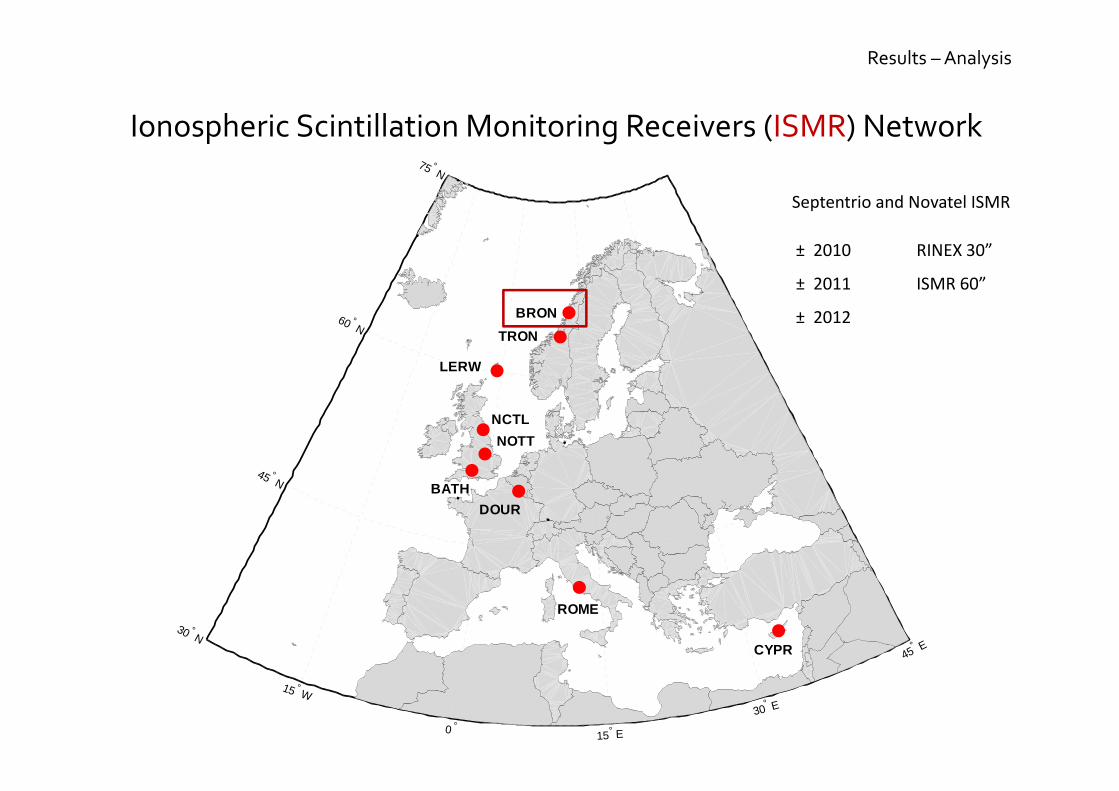
1. Spatial Autocorrelation Test
The « Spatial Strategy relies on the fact there exists some
Spatial Autocorrelation in Scintillations Observations
Results – Stochasticity
0h 3h 6h 9h 12h-1
-0.8
-0.6
-0.4
-0.2
0
0.2
0.4
0.6
0.8
1
Time [h]
Moran's I
Simulated Scenario
N
E
S
W
0°
30°
60°
1. Spatial Autocorrelation Test
The « Spatial Strategy relies on the fact there exists some
Spatial Autocorrelation in Scintillations Observations

Results – Stochasticity
N
E
S
W
0°
30°
60°
1. Spatial Autocorrelation Test
2. Covariance Function
Description of the Spatial Covariance of a
random Variable process
The « Spatial Strategy relies on the fact there exists some
Spatial Autocorrelation in Scintillations Observations

Results – Stochasticity
30 ° W
20 ° W
10 ° W 0° 10° E
20° E
30° E
40° E
50 ° N
60 ° N
70 ° N
80 ° N
N
E
S
W
0°
30°
60°
1. Spatial Autocorrelation Test
2. Covariance Function
The « Spatial Strategy relies on the fact there exists some
Spatial Autocorrelation in Scintillations Observations

Results – Stochasticity
1. Spatial Autocorrelation Test
2. Covariance Function
30 ° W
20 ° W
10 ° W 0° 10° E
20° E
30° E
40° E
50 ° N
60 ° N
70 ° N
80 ° N
��
��
�I
The « Spatial Strategy relies on the fact there exists some
Spatial Autocorrelation in Scintillations Observations

Results – Stochasticity
The « Spatial Strategy relies on the fact there exists some
Spatial Autocorrelation in Scintillations Observations
1. Spatial Autocorrelation Test
2. Covariance Function
United Kingdom - Ordnance Survey Network
10° W 5° W 0°
50° N
55° N
60° N
United Kingdom – Ordnance Survey Network CHAIN – Canadian High Artic Ionospheric Network
70 ° N
75 ° N
80 ° N
120 ° W
115 ° W
110 ° W 105 ° W
100 ° W 95° W 90° W 85° W 80° W
75° W 70
° W 65
° W
60° W
60 ° N
65 ° N
3. RNX vs. ISMR
ISMR
RNX
Spatial
Density
Variable?
Time Correlation?
Multi-receiver?
Mapping Function?
Scintillation Level?
Time Sampling?
Polar / Equatorial Scintillations?

Results – Stochasticity
The « Empirical Strategy relies on Observations
whatever their Locations
2h 3h 4h 5h 6h 7h
Time [h]
=Σ
221
22221
11221
...
..........
..
..
nnn
n
n
t
σσσ
σσσσσσ
S4, σϕ ?
C/N0?
S1C?
C1C?
L1C?
D1C?
RoTEC ?
…
…
Tracking E ?

Introduction
Research
Perspectives
Objectives
Conclusions Softwares
Analysis
Stochasticity
Geometry
Preprocessing

Results – Geometry
PPOS DOP σσ ×=
Ionospheric Scintillation involve Satellite Signal Losses

Brønnøysund
287/12 13-Oct-2012
2
4
6
8
KP
00h 03h 06h 09h 12h 15h 18h 21h 24h
2
4
6
8
10
12
Satellites
2468
101214
PDOP
Results – Geometry
Ionospheric Scintillation increase the Dilution of Precision
< 0.25
[ 0.25 – 0.4 [
[ 0.4 – 0.55 [
> 0.55
9 satellites
9 satellites

Results – Geometry
The Dilution of Precision depends on the amount and
the Spatial Distribution of Tracked Satellites
N
E
S
W
0°
30°
60°
PDOP = 10.79
N
E
S
W
0°
30°
60°
PDOP = 2.58

Results – Geometry
A Conical Satellite Geometry drives the DOP to Infinite Values
PWAPAAx TT 1)( −−=22121)( PxPP
T
xQNAA σσσ === −−∑
PPOS DOP σσ ×=
44342414
34332313
24232212
14131211
:
qqqq
qqqq
qqqq
qqqq
Qx
11ˆ )( −− == AANQ Tx
−−−
−−−−−−
=
1sincoscossincos
............
1sincoscossincos
1sincoscossincos22222
11111
nnnnn
A
ηχηχη
ηχηχηηχηχη
Any linear dependence?

Results – Geometry
A Conical Satellite Geometry drives the DOP to Infinite Values
N
E
S
W
0°
30°
60°
PDOP = 10.79
N
E
S
W
0°
30°
60°
PDOP = 2.58

Results – Geometry
PDOP = 10.79 PDOP = 2.58
N
E
S
W
0°
30°
60°
N
E
S
W
0°
30°
60°
A Conical Satellite Geometry drives the DOP to Infinite Values

Results – Geometry
N
E
S
W
0°
30°
60°
PDOP = 4.39
A Conical Satellite Geometry drives the DOP to Infinite Values

Results – Geometry
PDOP = 152.05
N
E
S
W
0°
30°
60°
N
E
S
W
0°
30°
60°
A Conical Satellite Geometry drives the DOP to Infinite Values

Introduction
Research
Perspectives
Objectives
Conclusions Softwares
Analysis
Stochasticity
Geometry
Preprocessing

Results – Preprocessing
�
�:�� t � 1�� 2 ��� , ��,4,;� 2 c ∆"� , ∆"� 2 <4��,4� 2 8�,4,;� 2 9�,4,;�
JK 2 � Testing Quantity
Detection Method
Correction Method
time
time
Cycle Slip Detection/Repair is a real need for
Precise Positioning Technique

Results – Preprocessing
1 2 3 4 5 Time [h]
-5
0
5
DF WLNL E1/E5a
[cycles]
-0.01
0
0.01
TF LCP E1/E5a/E5b
[m]
No CS
detected
Wrong
CS
detected
Giove-B TQs
99% Confidence Interval
The availability of Three Frequencies
makes the CS Detection more efficient
Validation of the Detection under IS
Development of a Correction Method
Adaptation to PPP

Results – Preprocessing
Observable Noise Assessment could help to define the
Stochastic Model (« Empirical Strategy »)
12 13 14 Time [h]
-1
0
1
Polynomial fitting
P-φ [m]
-2
-1
0
1
2
Time differencing
P-φ [m]

Introduction
Research
Perspectives
Objectives
Conclusions Softwares
Analysis
Stochasticity
Geometry
Preprocessing

Softwares
Analysis
Stochasticity
Geometry
Preprocessing
Symptomatic Analysis for a HL Station
Methodology
Equatorial Scintillations?
Conclusions

Softwares
Analysis
Stochasticity
Geometry
Preprocessing
Conclusions
Spatial / Empirical Strategies
Softwares
Analysis
Stochasticity
Geometry
Preprocessing
Illustration of Geometric Problems
Conclusions

Softwares
Analysis
Stochasticity
Geometry
Preprocessing
CS Detection Method
Validation of CS Detection for IS
Development of CS Repair Technique
Conclusions

Introduction
Research
Perspectives
Objectives
Conclusions

Perspectives
Introduction
Conclusions
State of the Art
Analysis GeometrySoftwares Stochasticity Preprocessing
Analysis
Solution
Validation
Analysis
Softwares
Preprocessing
Stochasticity
Geometry
100 10 20 40 15 15
- Versioning
- Python learning
- C learning
- Global Approach
- Global Design
- Adapations
- Stochastic Model
- Preprocessing
- Mathematic Model
- Weigthing Scheme
- Automatisation
- Stoch. Matlab Module
- Matlab routines
- Matlab mapping TB
- Matlab exe
- GIS software
Finalization
Jan14 Feb14 Mar14 Apr14 May14 Jun14 Jul14 Aug14 Sep14Oct13 Nov13 Dec13Jul13 Aug13 Sep13Jun13
FP
- Data Access
- Data Types
- Data Parsing
- Data Network
- Data Documentation
- Data Download
- Data Mapping
- Network Design
- SPP Process
- PPP Process
- SS Analysis
- MS Analysis
- Symptoms
Short Stay in Nottingham?
- Spatial Approach
ACS Study (Index)
ACS Study (covar.)
Corr. Observables
Index (RNX)
Spatial Interpolation
Covariance
Assesment
- Empirical Approach
Filter Construction
Tests
- Validation
gLAB
- Conical Theory
- M-GNSS
- Validation?
- CS Detection
TQ DF+TF
Filter Parameters
Validation DF+TF
- CS Repair
- Noise Assessment
Publication
Conference


Matthieu Lonchay
Performances under Ionospheric Scintillations
Geomatics Unit
Thesis Committee
June 11, 2013
Geomatics Unit, ULg
University of Liège, Belgium
F.R.S.-FNRS, Belgium
Satellite Positioning