Embed Size (px)
Citation preview

Townsville City Plan Version 2019/01 - Commenced 25 February 2019 SC6/58
SC6.4.2 Development application guidelines
SC6.4.2.1 Introduction
This section provides standards, advice and guidelines for development applications, including well made application
details along with design requirements to assist applicants in achieving council’s design objectives.
SC6.4.2.1.1 Definition of major and minor developments
(1) A major development consists of a combination or some or all of the following:
(a) more than six residential, commercial or industrial lots; or
(b) a single or multistorey mixed/high density dwelling unit complex of more than six dwellings; or
(c) a multistorey development of more than three stories; or
(d) a commercial structure where the ultimate Gross Floor Area (GFA) exceeds 2,000m2 and is two
equivalent stories or more; or
(e) a development where site filling and/or excavation exceeds 2,500m3; or
(f) a development where site filling impacts on a known or designated ‘floodplain’ and requires
compensatory earthworks to cater for the flows from the defined flood event in the adjacent or nearby
watercourse without increasing flood levels upstream and downstream of the development site; or
(g) a development that requires more than 300 carparking spaces.
(2) A minor development consists of a combination of some or all of the following:
(a) more than two and less than six residential, commercial or industrial lots; or
(b) a single storey (or higher) mixed/high density dwelling unit complex of six or less dwellings; or
(c) a mulitstorey development of not more than three stories of approved use; or
(d) development where site filling and/or excavation is less than 100m³; or
Editor’s note—where the site filling/excavation exceeds 100m3, but is less than 2500m³, the combination with other criteria will
determine whether the development is classified as major.
(e) a development where twenty or less carparking spaces are required.
Editor’s note—where required carparking spaces exceeds 20, but is less than 300, the combination with other criteria will
determine whether the development is classified as major.
Editor’s note–where a development does not meet any or only one of the criteria listed in major or minor development above,
council retains the prerogative to determine whether the development is major or minor.

Townsville City Plan Version 2019/01 - Commenced 25 February 2019 SC6/59
SC6.4.2.2 General
Council’s general procedures when lodging development applications are set out below.
SC6.4.2.2.1 Prelodgement advice guidelines
(1) Council will facilitate prelodgement meetings when requested to discuss development proposals prior to
lodgement. Prelodgement meetings can comprise of informal discussions or alternatively a formal response
can be arranged for more complex applications. The latter will require advanced lodgement of details including
reports, drawings and any information pertinent to the proposal to ensure an effective response to an applicant.
A team of specialists will attend a formal meeting followed by written minutes of the proceedings.
Editor's note—A sliding fee will be applicable where stated in council’s applicable fees and charges schedule.
Editor’s note—Planning and Development’s Schedule of fees and charges can be found on council’s website.
Prelodgement discussions may include, but is not limited to, consideration of the following matters:
(a)
(b)
(c)
(d)
(e)
(f)
(g)
(h)
(i)
(j)
(k)
(l)
(m)
environmentally significant areas;
stormwater discharge (legal lawful point of discharge);
impacts of flooding/inundation;
conceptual stormwater quality requirements and tailwater conditions/levels;
overall water supply and pressure;
overall sewerage reticulation;
existing site conditions/constraints such as steep slopes, proximity to identified watercourses, existing
utilities;
lot and road layout design including existing traffic issues;
traffic management strategy;
landscape/streetscape;
building setbacks and access requirements;
relevant development permit conditions e.g. preliminary approvals or identify other required approvals e.g.
referral to other agencies;
variation to council standards and guidelines to explore possible solutions to design issues;

Townsville City Plan Version 2019/01 - Commenced 25 February 2019 SC6/61
(n) design and layout; and
(o) building form and layout.
It is expected that resolving the above matters may significantly reduce the time for council officers in
assessing the application and expedite the approval of the designs, presupposing all other requirements are
submitted in order.
The prelodgement process is a without prejudice meeting designed to allow an exchange of information in
respect to the intended development prior to submitting a formal development application. It is not intended to
provide a detailed assessment audit against applicable planning scheme codes, planning scheme polices, or to
determine the likely outcome of the proposed development. Furthermore, prelodgement meetings cannot take
into consideration other third party interests such as referral agencies or anticipate possible adverse comments
received from submitters in the notification stage.
(2) Meeting minutes will normally be taken at the meeting by a council officer, which can be forwarded to the
applicant after the meeting (upon request) and registered in council’s records system. However, attendees are
encouraged to make their own notes.
(3) Prelodgement meetings are conducted by appointment only and would normally be of 12 hours duration
depending on the complexity of the proposal. To request a prelodgement meeting, the applicant must
complete a PreLodgement Meeting Request Form (refer to SC6.4.2.2 Attachment A Prelodgement meeting
request form), which can be submitted either by email or to the Planning and Development Counter, Level 2,
Council Administration Building – Walker Street. The request must be accompanied with all relevant material
including concept, layout or design plans and a brief covering letter or report detailing any specific issues.
SC6.4.2.2.2 Design requisites and quality assurance guidelines
(1) The developer/applicant is encouraged to engage and nominate appropriately qualified consultants/individuals
with the required expertise to undertake design work on their behalf. The consultants are expected to have
systems in place to assure the quality of the designs and the reports that they produce. It is the consultant’s
responsibility to ensure that the design complies with and has satisfied all relevant council requirements and
conditions of the associated development approval.
Concept and detailed designs must comply with the relevant conditions of the Development Approval, council
policies, Townsville City Plan and relevant provisions of this Development manual planning scheme policy. All
designs must be prepared and certified by an appropriately qualified professional with relevant experience.
Quality assurance personnel shall be:
(a) engineering works (including geotechnical, hydraulic, stormwater infrastructure, civil, structural or electrical engineering) - Registered Professional Engineer of Queensland (RPEQ) as defined under the
Professional Engineers Act 2002;
(b) landscape works Registered Landscape Architect with the Australian Institute of Landscape Architects
(AILA) or a Landscape Designer with the Australian Institute of Landscape Designers and Managers
(AILDM); and
(c) irrigation works Certified Irrigation Designer or Certified Irrigation Agronomist where irrigation works are
within the public realm.; and
(c)(d) erosion and sediment control plan - Certified Professional in Erosion and Sediment Control (CPESC)
or a RPEQ who has undertaken the Erosion and Sediment Control training provided by the
International Erosion Control Association with demonstrated specialist expertise in the relevant
subject matter.
(2) The Consultant must retain appropriate design records including calculations in a format such that they can be
understood readily by design staff with no prior knowledge of the particular design. The design file must be
maintained by the developer/applicants or the developer/applicant's consultant containing records of
calculations, approvals and decisions, geotechnical data and other design data which could be relevant in
reviewing aspects of the design or planning future maintenance responsibilities. Copies of records are to be

Townsville City Plan Version 2019/01 - Commenced 25 February 2019 SC6/62
made available to council on request and without charge.
(3) Council retains the right to audit all processes and documents related to the development design. The
developer/applicants and the developer/applicant's consultant must provide council officers all reasonable
assistance in inspecting records of designs submitted to council for acceptance.
SC6.4.2.2.3 Documentation guidelines
To further assist developers in the process of lodging development applications, a wellmade application checklist has
been prepared by council and the completion of a particular checklist, and submission of all relevant accompanying
information, will expedite the assessment process (refer to SC6.4.2.4 Wellmade application checklists).
(1) Portable long service leave (PLSL)
Development Approvals for Operational Works cannot be issued by council until appropriate evidence of
payment of the Portable Long Service Leave fees are provided as prescribed by the Building and Construction
Industry (Portable Long Service Leave) Act 1991
(2) Certification and design reports
All designs to be accompanied with certification and design reports which must be signed by a qualified
professional with relevant experience (see SC6.4.2.2.2(1)). The Certification Report will comprise the Certificate
(SC6.4.2.2 Attachment B – Certification Report) and Design Report. The Design Report must contain
documentation as required by SC6.4.2.2.3(4) and SC6.4.2.2.3(5) below.
The certification and design reports will be required with preliminary designs and will require resubmission with
updates when final drawings are submitted. Certification is not required with sketch plans or concept plans.
The consultant must provide a detailed justification for each variation to or noncompliance with council’s design
and construction requirements, local laws, Townsville City Plan planning scheme policies and Townsville City
Plan and relevant development approval conditions, as part of the Certification Report.
(3) Design drawings and work specifications
The consultant on behalf of the developer must present all design drawings and specifications for the
development works to council for audit purposes.
The design drawings must be complete and clearly set out so as to present the design concepts in such a way
that the project can be understood, specified for construction and satisfactorily built. Unless noted otherwise,
the submission should comprise a full set of plans for proposed works (1 x A3 drawings and a digital copy in
PDF format correctly scaled as per councilpreferred sheet size).
All work specifications must be prepared by the consultant and submitted to council for review, specifying
requirements not covered by council’s standard work specifications.
Full design drawings and work specifications covering all aspects of the proposed works must be submitted to
council for acceptance. Standard drawings and works specifications (if available) from the following sources are
to be included in order of preference:
(a) Standard drawings (SC6.4.4.8);
(b) Council design specifications (SC6.4.4) and Construction standards (SC6.4.6); and
(c) Department of Transport and Main Roads.
Where council’s standard specifications are used unaltered, they may be referenced as such in the documents
and may be omitted from the submitted set of specifications.
All Design drawings and work specifications must be certified by an appropriately qualified professional with
relevant experience (see SC6.4.2.2(1)).
(4) Design documentation for material change of use applications
Applicants should submit the following documentation where necessary in support of the proposal:

Townsville City Plan Version 2019/01 - Commenced 25 February 2019 SC6/63
(a) site analysis plan;
(b) elevation plans, floor plans (if necessary);
(c) traffic impact assessment, hydraulic report, geotechnical reports, acoustic report, stormwater quality

Townsville City Plan Version 2019/01 - Commenced 25 February 2019 SC6/62
management plan, waste management safety in design report and other specialist reports necessary to
support the development application;
(d) water and sewer modelling (if necessary) refer to SC6.4.3.23 Water and sewer network modelling
guidelines; and
(e) landscape and irrigation plans.
(5) Design documentation for reconfiguring a lot applications
Applicants for staged developments should submit master plan documentation where necessary showing a
subdivision’s overall design concept for:
(a)
(b)
(c)
(d)
(e)
(f)
(g)
(h)
(i)
(j)
sewer and water (including pump stations);
stormwater quantity and stormwater quality (SC6.4.3.8 Stormwater quality management plans for
development);
earthworks including conceptual erosion and soil control plan (refer to SC6.4.4.5 Earthworks (design));
road network (includes hierarchy, road and carriageway widths, noise impact and traffic studies);
acoustic report, geotechnical report and any specialist report necessary to support the development
application;
public transport;
servicing details (utilities);
pedestrian and cycle network;
Safety in design reports for all infrastructure that does not comply with relevant sections of the
Development manual; and
landscape and irrigation.
For nonstaged developments; applicants should submit:
(k) lot layout;
(l) proposed road and access network;
(m) servicing details (utilities);
(n) stormwater management;
(o) Safety in design reports for all infrastructure that does not comply with relevant sections of the
Development manual;
(p) Safety in design reports that demonstrate that sewer connection points and maintenance structures
located at rear of lots are still accessible at all times; and
(q) any specialist report necessary to support the development application.
(6) Documentation for operational works and compliance applications
Applicants should submit where necessary to support the application the following documentation as part of
the application (depending on scope of development works):
(a) design drawings (1x A3 size and an electronic copy in PDF);
(b) work specifications (one copy);
(c) copy of the associated Development Approval (if any);
(d) certified detailed Schedule/Bill of Quantities by a suitably qualified and experienced professional (see
SC6.4.2.2.2(1));
(e) landscape statement of intent (see SC6.4.2.5(7)(1)(c) Landscape statement of intent);
(f) landscape and irrigation plans (see SC6.4.2.5(7) Landscape drawings and SC6.4.2.5(8) Irrigation
drawings);
(g) stormwater drainage design calculations including design of structures (e.g. open drains, detention
basin), catchment plans (internal and external);
(h) stormwater quality management plan including the design criteria and details;

Townsville City Plan Version 2019/01 - Commenced 25 February 2019 SC6/63
(i)
(j)
(k)
(l)
(m)
(n)
(o)
(p)
(q)
(r)
water network analysis (refer to SC6.4.3.23 Water and sewer network modelling guidelines);
sewer network analysis (refer to SC6.4.3.23 Water and sewer network modelling guidelines);
subgrade test results and pavement designs;
engineering certification of structural designs;
preliminary erosion and sediment control plan (refer to SC6.4.2.2.7 Conceptual and preliminary erosion
and sediment control plan);
traffic management plan (if required);
traffic report (if required);
geotechnical reports (where relevant);
conduit assessment of existing infrastructure (refer to SC6.4.2.2.6 Conduit assessment) Safety in
Design; and
any other information required by the associated development approval and under relevant legislation, or
relevant to support the assessment of the application.
Minimum documentation required during application
Documentation Material change of use Reconfiguring a lot Operational work
Safety in design report
Site based stormwater management plan
Concept plan required - when stormwater quantity, quality, frequency and flood flow management or waterway stability infrastructure is provided. Detailed information on stormwater system (i.e. dimensions, levels and outlet details of detention basin) to be provided if no operational work application is required.
Concept plan required - when stormwater quantity, quality, frequency and flood flow management or waterway stability infrastructure is provided.
Detail plan required - when stormwater quantity, quality, frequency and flood flow management or waterway stability infrastructure is provided.
Flood study report Required (determined by the type and scale of development).
Required (determined by the scale of development).
Required if not presented in earlier application.
Electricity reticulation plan NA NA Required.
Erosion and sediment control plan NA Conceptual erosion and soil control plan needed for staged developments.
Required.
Filling and excavation plan Concept plan required. Concept plan required. Detail plan required.
Inter-allotment drainage plans Required where downstream discharge involves other private properties.
Required where downstream discharge involves other private properties.
Required where downstream discharge involves other private properties.
Landscape site analysis Required (if assessable development).
Required (if assessable development).
NA
Landscape concept plan Required (if assessable development).
Required (if assessable development).
NA
Landscape detailed working drawings
NA NA Required where landscaping is proposed.
Landscape detailed maintenance program for on-maintenance
NA NA Required where land or infrastructure will be managed by the local government.
Sewerage reticulation plan Concept plan required. Concept plan required. NA
Sewerage reticulation detailed design drawings
NA NA Detailed design required.
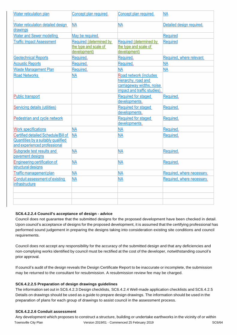
Townsville City Plan Version 2019/01 - Commenced 25 February 2019 SC6/64
Water reticulation plan
Concept plan required. Concept plan required. NA
Water reticulation detailed design drawings
NA NA Detailed design required.
Water and Sewer modelling May be required. Required
Traffic Impact Assessment Required (determined by the type and scale of development)
Required (determined by the type and scale of development)
Required
Geotechnical Reports Required. Required. Required, where relevant
Acoustic Reports Required. Required. NA
Waste Management Plan Required. NA NA
Road Networks NA Road network (includes hierarchy, road and carriageway widths, noise impact and traffic studies).
Public transport Required for staged developments.
Required.
Servicing details (utilities) Required for staged developments.
Required.
Pedestrian and cycle network Required for staged developments.
Required.
Work specifications NA NA Required.
Certified detailed Schedule/Bill of Quantities by a suitably qualified and experienced professional
NA NA Required.
Subgrade test results and pavement designs
NA NA Required.
Engineering certification of structural designs
NA NA Required.
Traffic management plan NA NA Required, where necessary.
Conduit assessment of existing infrastructure
NA NA Required, where necessary.
SC6.4.2.2.4 Council's acceptance of design advice
Council does not guarantee that the submitted designs for the proposed development have been checked in detail.
Upon council’s acceptance of designs for the proposed development, it is assumed that the certifying professional has
performed sound judgement in preparing the designs taking into consideration existing site conditions and council
requirements.
Council does not accept any responsibility for the accuracy of the submitted design and that any deficiencies and
noncomplying works identified by council must be rectified at the cost of the developer, notwithstanding council’s
prior approval.
If council’s audit of the design reveals the Design Certificate Report to be inaccurate or incomplete, the submission
may be returned to the consultant for resubmission. A resubmission review fee may be charged.
SC6.4.2.2.5 Preparation of design drawings guidelines
The information set out in SC6.4.2.3 Design checklists, SC6.4.2.4 Wellmade application checklists and SC6.4.2.5
Details on drawings should be used as a guide to prepare design drawings. The information should be used in the
preparation of plans for each group of drawings to assist council in the assessment process.
SC6.4.2.2.6 Conduit assessment
Any development which proposes to construct a structure, building or undertake earthworks in the vicinity of or within
Townsville City Plan Version 2019/01 - Commenced 25 February 2019 SC6/65
the “zone of influence” of an existing conduit may be required to identify the condition of the conduit for assessment of
serviceability and structural compatibility with the proposed development work. Any upgrading or replacement
determined by council will be carried out at the developer's expense prior to the commencement of any development
works.
(1) CCTV inspection criteria general criteria for closed circuit television (CCTV) sewer and stormwater
assessments for operational works/compliance permits are as follows:
(a) sewer:
(i) major developments (refer to SC6.4.2.1.1(1)):
(A) prior to commencement of the defects liability period; and
(B) if defects are identified they must be rectified, and the sewer, for the entire length between
the upstream and downstream maintenance holes (MHs), must be assessed again prior to
completion of the defects liability period.
(ii) minor developments (refer SC6.4.2.1.1(2)):
(A) systems containing two or more sewer lengths, or systems containing sewer lengths that
exceed a combined service length of 60 m measured centre to centre between manholes
require assessment prior to commencement of the defects liability period;
Townsville City Plan Version 2019/01 - Commenced 25 February 2019 SC6/64
(b)
(A)
(B)
stormwater:
if defects are identified they must be rectified, and the sewer, for the entire length between
the upstream and downstream maintenance holes (MHs),must be assessed again prior to
completion of the defects liability period; and
where a defects liability period does not apply, CCTV assessment is mandatory prior to
acceptance.
(i) interallotment systems located on private property are exempt;
(ii) rubber ringed jointed pipe systems with flexible joints immediately outside chambers (includes
PVC and Polythene pipe systems) will be visually assessed and are exempt subject to the
system presenting defect free;
(iii) CCTV assessment of flush end RCP pipe systems is mandatory;
(iv) major developments (refer to SC6.4.2.1.1(1)):
(A) prior to commencement of the defects liability period; and
(B) prior to completion of the defects liability period.
(v) minor developments refer to SC6.4.2.1.1(2)):
(A) systems exceeding a service length of 60 m require assessment prior to commencement of
the defects liability period; and
(B) where a defects liability period does not apply, CCTV assessment of the system is
mandatory prior to acceptance.
(2) Qualification and training of CCTV operators and supervisors the assessment must be undertaken by a
suitably trained and qualified contractor, in accordance with the relevant sections of the current version of
Water Services Association of Australia’s Conduit Inspection Reporting code of Australia (WSA05) and the
results are to be submitted to council in CD, DVD or any digital storage device acceptable to council
accompanied by a written condition assessment report to be approved in writing by council prior to the
issuance of any Development Approvals.
In the event of noncompliance in preparation and submission of the conduit assessment, council may require
the developer to reperform the inspections and resubmit. All costs incurred conducting these additional
conduit assessments will be the responsibility of the contractor.
(3) Site establishment – the contractor is responsible for the following requirements:
(a) any necessary approvals from statutory authorities in order to complete the required work;
(b) any temporary electric light, power installations and water supply including all charges incurred;
(c) public notification if necessary – contractor must notify affected residents/adjacent property
owners/commercial business owners and council (including if the area to be closed is public open
space). Additional requirements may be necessary if closures are to be over an extended period of time.
Notification is required prior to commencement of work;
(d) plans of existing services are to be verified by the contractor. Council does not guarantee the accuracy of
the information on these plans;
(e) environmental management plan – if necessary, the contractor must prepare and implement a site
specific environmental management plan, for inspections which would involve interference to live services
e.g. sewer line which poses an environmental risk. The Plan must detail activities and measures to
ensure that the inspection is performed in a manner which minimises risk of causing environmental
nuisance or harm;
(f) reinstatement – cleanup, repair and reinstate any areas affected or impacted by the works, at their own
cost;
(g) maintaining the service in all conduits being inspected;
(h) pipe cleaning – conduits being inspected must be sufficiently clean to allow proper visual identification of
existing defects. The proper disposal of debris from the cleaning shall be the responsibility of the
Townsville City Plan Version 2019/01 - Commenced 25 February 2019 SC6/65
(i)
(j)
contractor;
traffic management – where the diversion of vehicular and pedestrian traffic is required, the contractor is
responsible for implementing an appropriate traffic management plan; and
occupational health and safety – the contractor is required to comply with all statutory and other current
regulations relating to occupational health and safety.
(4) Inspection report – The production of reports (including mandatory information), detailing the condition of
surveyed conduits, all coded and scored to standards that satisfy the requirements of current WSA 05 Code.
(5) Inspection software – The preferred software for use in reporting on conduit inspections is the current of
WinCan, set up to report as per the current WSA 05 code. If a contractor proposes to use alternative software,
a full detail of the software must be provided to council for approval which includes the capabilities must be
provided and must be fully compatible with the WinCan software.
(6) Data ownership – Full ownership of the survey and report data including intellectual property rights to the digital
visual records and its contents must be with council.
SC6.4.2.2.7 Conceptual and preliminary erosion and sediment control plan
Soil disturbance is inevitable in any development; it is fundamental to develop measures to reduce the impact of soil
erosion in every stage of construction to an acceptable level of sediments leaving the development site.
For reconfiguring a lot, material change of use, operational works and compliance assessment applications,
depending on the scope of development, associated environmental impacts, site constraints (e.g. land use, lot layout
site topography, proximity to bodies of water) and other factors, the developer should identify the erosion risk level of
the proposed development, which can be determined by assessing the erosion hazard of the intended development
site outlined in SC6.4.3.8 Stormwater management plans for development and Appendix F – Erosion Hazard
Assessment of the International Erosion Control Association’s Best Practice Erosion and Sediment Control (IECA
BPESC).
Where a development site of a development application was assessed as being a high-risk site, the developer should
provide a conceptual erosion and sediment control plan (CESCP). The conceptual document should take into
consideration the key principles of erosion and sediment control detailed in this clause, and the site planning aspects
and guideline in preparing conceptual plans in SC6.4.3.8 Stormwater management plans for development.
Where a development site was assessed as being a lowrisk site and where a CESP has been accepted by council, a
preliminary erosion and sediment control plan (PESCP) must be submitted to council as part of the operational works
or compliance applications. The PESCP must be prepared in accordance with the design standards and technique
selection outlined particularly in:
(1) Chapters 2 – Principles of erosion and sediment control;
(2) Chapter 4 – Design standards and technique selection;
(3) Chapter 5 – Preparation of plans; and
(4) also including the appropriate Model Code of Practice and Specific Guidelines in:
(a) Appendix G – Model code of practice;
(b) Appendix H – Building sites;
(c) Appendix I – Instream works;
(d) Appendix J – Road and rail construction;
(e) Appendix K – Access tracks and trails; and
(f) Appendix L – Installation of services of IECA BPESC.
During the Pre Start Meeting, the applicability and appropriateness of the PESCP will be reviewed onsite and
revisions will be required if necessary.

Townsville City Plan Version 2019/01 - Commenced 25 February 2019 SC6/66
For general guidance in implementation of erosion and soil control plan refer to SC6.4.3.8 Stormwater management
plans for development.
SC6.4.2.2 Attachment A – Prelodgement meeting request form
Click here to view Prelodgement meeting request form.
SC6.4.2.2 Attachment B – Certification report
Click here to view Certification report

Townsville City Plan Version 2019/01 - Commenced 25 February 2019 SC6/67
SC6.4.2.3 Design checklists
SC6.4.2.3.1 Design Checklist 1 Base plot of existing features
Click here to obtain a copy of the following form
SC6.4.2.3.2 Design Checklist 2 Horizontal road alignment
Click here to obtain a copy of the following form
SC6.4.2.3.3 Design Checklist 3 Vertical road alignment
Click here to obtain a copy of the following form
SC6.4.2.3.4 Design Checklist 4 Road cross sections
Click here to obtain a copy of the following form
SC6.4.2.3.5 Design Checklist 5 Road and interallotment drainage
Click here to obtain a copy of the following form
SC6.4.2.3.6 Design Checklist 6 Signs and markings
Click here to obtain a copy of the following form
SC6.4.2.3.7 Design Checklist 7 Pavement design
Click here to obtain a copy of the following form
SC6.4.2.3.8 Design Checklist 8 Bridge major culvert design
Click here to obtain a copy of the following form
SC6.4.2.3.9 Design Checklist 9 Landscape and Irrigation Plans
Click here to obtain a copy of the following form
SC6.4.2.3.10 Design Checklist 10 Erosion and sedimentation control plans
Click here to obtain a copy of the following form
SC6.4.2.3.11 Design Checklist 11 QAF0477 Sewage pump station and pressure main checklist
Click here to obtain a copy of the following form.
SC6.4.2.3.12 Design Checklist 12 QAF0477 Sewer reticulation checklist
Click here to obtain a copy of the following form.
SC6.4.2.3.13 Design Checklist 13 QAF0478 Water reticulation checklist
Click here to obtain a copy of the following form.
SC6.4.2.3.14 Design Checklist 14 QAF0479 Water and sewer model checklist
Click here to obtain a copy of the following form.
SC6.4.2.4 Wellmade applications checklists
SC6.4.2.4.1 Material Change of use Development Assessment Checklist
Click here to obtain a copy of the following form
SC6.4.2.4.2 Reconfiguring a lot Development Assessment Checklist
Click here to obtain a copy of the following form
SC6.4.2.4.3 Compliance Development Assessment Checklist
Click here to obtain a copy of the following form
SC6.4.2.4.4 Operational Works Development Assessment Checklist
Click here to obtain a copy of the following form
SC6.4.2.5 Details on drawings guidelines
SC6.4.2.5.1 General requirements guidelines
(1) The information shown on the drawings must be logically collected on discrete sheets to avoid illogical and
onerous effort in cross referencing between sheets in order to find information. This policy section details
Townsville City Plan Version 2019/01 - Commenced 25 February 2019 SC6/68
minimal information requirements for plans and drawings submitted for assessment.
(2) Drawings should not be overcrowded with information and should not rely on colour printing or colour wash to
impart information.
(3) The preferred submission method is uploading to the Townsville Online Lodgement System (TOLS). The
preferred sheet sizes of drawing sheets are:
(a) A1 size (841 mm x 594 mm); and
(b) A3 size (420 mm x 297 mm).
(4) The preferred scales for use should generally conform with the recommendations of AS 1100.101 Technical
Drawing – General principles. Generally the following scales are to be used 1:10, 1:20, 1:50 and multiples of 10
of these scales.
(5) Electronic and hard copies of drawings should be true to scale A1 size sheets and be suitable for black and
white printing, copying and photo reduction to A3 size without loss of clarity.
(6) The drafting should be of a standard generally in accordance with the requirements of AS 1100.
(7) Title block – All drawings must, within the boundaries of the title block, clearly indicate the following:
(a)
(b)
(c)
(d)
(e)
(f)
(g)
(h)
(i)
(j)
(k)
(l)
(m)
project title e.g. estate name (if any);
real property description;
locality;
developer’s name;
details on contents of drawings e.g. sewer reticulation;
scales – bar scales;
plan and sheet number;
schedule and date of revisions;
survey datum;
street names;
date of initial issue;
legend and north point; and
signed design certification.
(8) Typical scales – the following scales are suggested for particular uses but these may be varied as appropriate
to the works concerned:
(a) plans – 1:1000 (rural) and 1:500 (urban);
(b) longitudinal section horizontal – 1:1000 (rural) and 1:500 (urban);
(c) longitudinal section vertical – 1:100 (rural) and 1:50 (urban);
(d) intersection details 1:250 or 1:100; and
(e) cross sections – 1:100.
(9) Survey datum – Level information should be referenced to the Australian height datum (AHD). Position
coordinates should be tied to the GDA94 datum based on the Mapping Grid of Australia (MGA) coordinate
system.
(10) Dimensioning
(a) Units All units should be expressed in metric units. Linear dimensions on all roadworks plans, with the

Townsville City Plan Version 2019/01 - Commenced 25 February 2019 SC6/69
exemption of some details of small structures and standard details which may be in millimetres.
(b) Chainages – Chainages on plans should be expressed to three decimal places of a metre e.g. 0.123 m.
(c) Cross section intervals – Road cross sections should be provided at 20 metre intervals, with further
subdivision to 10 metre or 5 metre intervals where necessary due to horizontal or vertical curvatures.
(d) Grades – Road and pipe grades should be shown to three significant figures in percentage e.g. 1.234%.
SC6.4.2.5.2 Layout and stage plan guidelines
(1) For large developments, the layout plan shows the relationship of all new roads to each other, and to existing
roads adjoining the development.
(2) Where development is planned in stages, the boundaries of proposed stages are shown on the plan, and the
stages identified by numbering.
(3) Existing and proposed streets which are adjacent to or fronting the proposal are included on the layout plans.
(4) All services, natural features, significant trees and the like are shown on existing road reserves.
(5) Details of the permanent survey mark, including the AHD level from which the levels were transferred, are
included.
SC6.4.2.5.3 Roadworks and associated drainage drawings
(1) Plan – drawing should include the following details:
(a)
(b)
(c)
(d)
(e)
(f)
(g)
(h)
(i)
(j)
(k)
(l)
(m)
(n)
(o)
(p)
(q)
(r)
(s)
(t)
(u)
(v)
(w)
(x)
(y)
(z)
road reserve boundaries;
lot boundaries, both existing and proposed (levels provided at each boundary corner) and easements;
centreline or other construction line;
chainages on centreline or construction line or set out coordinates;
bearings of the centreline or construction line;
offsets (in tabular form) if the construction line is not the centreline;
tangent point chainages or coordinates of each curve;
radius and tangent length and superelevation of each curve;
road reserve boundaries, centreline, and bearing of each intersecting road;
chainage or coordinates of the intersection point of road centrelines;
kerb lip lines, kerb types, kerb face (setout) radii and chainage or coordinates of all tangent points of
kerb face (setout) lines;
edge of pavement, where no kerb and channel is proposed;
dimensioned road reserve, verge, concrete footpath and pavement widths, where these differ from the
standard cross section;
location and details of signs and road markings proposed;
drainline locations (including interallotment drainage), diameters and class of pipes or size of box
culverts, open drains and easements and invert levels;
the defined flood event levels;
manhole locations, chainage and offset or coordinates and invert and kerb levels;
stormwater flow arrows;
inlet pit and manhole locations tabulated to include type, type of jointing chainage;
culvert/channel and other structures details;
location of existing utilities or other existing works within the site;
limits and levels of lot filling or grading;
cut or fill depths and earthwork quantities;
coordinates of all set out points;
retaining wall (including details);
location and levels of bench marks and reference pegs;
Townsville City Plan Version 2019/01 - Commenced 25 February 2019 SC6/70
(aa)
(ab)
(ac)
service conduits locations;
details of all existing construction on or adjoining the proposed works; and
longitudinal and cross sections with invert levels and the required flood levels including existing and
proposed surface contours of constructed or natural open channels (e.g. table drains) and waterways
(including landscape, construction details and maintenance).
(2) Detail plans of intersections, turnaround areas, property accesses, culdesac, traffic calming (LATM) devices
(if required) and the like.
(a) Intersection detail plans include all relevant information required for plans together with additional details
such as tangent point chainages, kerb lip levels on all kerb returns, pavement contours and
channelisation works.
(b) The plans should also include relevant information as listed for standard cross section SC6.4.2.5(3)(4)).
(3) Longitudinal sections of roads – the longitudinal section of each road includes:
(a)
(b)
(c)
(d)
(e)
(f)
(g)
(h)
(i)
(j)
(k)
(l)
(m)
(n)
(o)
chainages;
datum RL, existing surface and peg levels;
design road centreline and lip of kerb levels and grades;
cut or fill depths and earthwork quantities;
design grades, length and radii of vertical curves;
chainage and level of grade intersection points and tangent points of vertical curves;
sight distance diagram for each direction of travel for collector or higher order roads only;
line marking (where applicable);
details of superelevation (where possible);
drainage lines and manholes intersecting centre line;
table drain grading and levels where no kerb and channel;
sight distance diagram for each direction of travel;
horizontal curve details;
existing and proposed services; and
pavement design and design speed.
(4) Type cross sections of road a standard cross section is shown for each road, including:
(a)
(b)
(c)
(d)
(e)
(f)
(g)
(h)
(i)
(j)
road reserve width;
pavement widths (lip to lip dimension);
road verge widths;
concrete footpath and cycle paths;
crossfalls of pavement and road verges;
pavement depth (including subsoil drainage);
type of kerb and channel;
type of pavement surfacing;
batter slopes; and
pegged or shift centre line.
(5) Cross sections of roads – a cross section is shown for each chainage on each road.
(a) A cross section should be shown at a minimum spacing of 20 m. Where roads are in steep terrain,
cross sections may be required at closer intervals. Cross sections are to be extended into the
allotments for the limit of batters. The crosssection plans are to include:

Townsville City Plan Version 2019/01 - Commenced 25 February 2019 SC6/71
(i) road reserve boundaries;
(ii) pavement centreline, and shift centre line or other construction lines;
(iii) natural surface;
(iv) design cross section;
(v) crossfall of pavement and road verge, pavement and road verge widths, and pavement depths,
wherever these differ from the standard cross section, e.g. superelevation and curve widening;
(vi) pavement and subsoil drainage; and
(vii) chainages.
(b) When existing bitumen sealed roads are widened, cross sections include the full existing sealed
pavement cross section at not more than 10 m intervals.
(c) Each cross section shows the percentage crossfall on the existing bitumen surface and the design
crossfall to the lip of the proposed kerb and channel.
(d) Notations on drawings also require the Supervising Engineer to check for any errors between the design
and the set out of the kerb and channel before the kerb and channel is constructed.
(6) Traffic signs and pavement markings plan – all required signage and pavement markings (including temporary
works) are to be provided in accordance with the current version of the MUTCD, Queensland.
(7) Longitudinal sections of drainlines – a longitudinal section of each drainline should be drawn along the centre
line of the drainline and should show:
(a)
(b)
(c)
(d)
(e)
(f)
(g)
(h)
(i)
(j)
(k)
(l)
chainages;
existing and proposed surface levels;
design invert levels, hydraulic grade lines, velocity, discharge;
manhole chainages, inlet and outlet invert levels, and finished surface levels of structures;
distances between manholes;
grade in percent, diameter, type and class of each pipe or size of each box;
references to the Council’s current standard drawings;
class of each pipe, length and type of pipe;
existing and proposed service locations and levels;
all piped drainlines and constructed or natural channels used to convey runoff as part of the development
are shown on drawings;
longitudinal sections and cross sections of all channels show the calculated hydraulic grade line for the
design frequency; and
piped drainlines are included either on the road longitudinal sections where applicable or detailed
separately.
(8) Stormwater drainage catchment plan – the catchment plans should indicate all catchments including external
catchments contributing to the stormwater drainage design and the following:
(a) full external catchment;
(b) development layout plan showing the roads and allotment boundaries;
(c) existing and finished surface contours (in different line types). Contour intervals are to be sufficient to
enable subcatchments to be defined;
(d) contours must be extended external to the site to enable the limits of all external catchments to be fully
defined;
(e) subcatchment boundaries, labels and areas;
(f) location of drainlines, manholes, inlet/gully pits, outlets, open drains etc.; and
(g) labelling of stormwater structures.

Townsville City Plan Version 2019/01 - Commenced 25 February 2019 SC6/72
SC6.4.2.5.4 Bicycle, pedestrian and shared path drawings guidelines
(1) All plans for bicycle, pedestrian and shared paths are to be presented at the reduction ratio 1:500 minimum or
1:200 preferable. The plans are to include details of the signs and pavement markings to be used and any
barriers, fences, holding rails, ramps, etc. The landscaping treatment should also be included in the plans.
(2) The cycleway bicycle path plan sheet may be incorporated into the road plan where clarity permits. Specific
details are to be provided at reduction ratio 1:200.
(3) Longitudinal sections will be required for all offroad pathways where grades are greater than or equal to 3%.
(4) Longitudinal sections will have reduction ratios of 1:500 horizontal and 1:50 vertical.
(5) Cross sections will be presented at 1:100 reduction ratio (natural) and transition tables will be required where
cross falls vary or superelevation is provided.
(6) A typical cross section will be detailed to indicate pavement materials and layer depths.
SC6.4.2.5.5 Sewerage drawings guidelines
(1) Sewerage layout plan the sewerage layout plan includes:
For development consisting of two or more stages, a preliminary master layout plan showing boundaries of all
stages. The plan shows proposed locations and sizes of all trunk mains, pumping stations and sewage
treatment plants, where relevant.
In addition, the sewerage layout includes:
(a) boundary of the development, lot layout and numbers, easements (if required), finished surface contours;
(b) nonsewered areas;
(c) references to the council’s current standard drawings;
(d) location, grades of all sewer lines, manholes (numbered) and other services where they cross;
(e) indicate trunk mains;
(f) pumping stations, maintenance structure numbers and sewer diameters;
(g) site plan for sewerage pump stations; and
(h) details of water and electricity supply, landscaping, access and control buildings, if applicable.
(2) Sewerage longitudinal sections the longitudinal section of each sewer line includes:
(a)
(b)
(c)
(d)
(e)
(f)
(g)
(h)
(i)
(j)
(k)
upstream and downstream invert levels;
existing and finished surface levels, depth to invert;
grade expressed as 1 in XX;
diameter, type and class of pipe;
chainage;
distance between maintenance structures;
concrete stops, where required;
manhole and/or shaft number;
manhole type and drop type;
location and depth of all underground services; and
the design invert level of each house connection branch, type and invert level of the branch.
SC6.4.2.5.6 Water drawings guidelines
(1) Water reticulation layout plan
For developments consisting of two or more stages, a master layout plan showing stage boundaries should
be provided. Locations of existing or proposed trunk mains, treatment plants or reservoirs are to be shown on
plan.
In addition, a water reticulation layout plan showing:
(a) pipe location;
Townsville City Plan Version 2019/01 - Commenced 25 February 2019 SC6/73
(b)
(c)
(d)
(e)
(f)
(g)
(h)
(i)
(j)
(k)
(l)
(m)
(n)
(o)
(p)
(q)
pipe material, diameter, type, class and joints, including fittings;
fire hydrant, valve, bends, junction locations;
size and location of all concrete anchor blocks, thrust blocks, and diaphragm walls;
cutin details;
crossroad conduit locations;
specific notes and instructions;
boundary of the development, lot layout and numbers, including easements;
proposed location for any pump stations, showing access details;
references to council’s current standard drawings (SC6.4.4.8 Standard drawings);
dimension from road alignment boundary/property boundary;
minimum clearances to other services;
pipe and fitting, internal and external protection details including at road pavement crossings;
trench cross section detail showing the pipes as well as bedding and filling materials for each size and
type of pipe;
pump curves if appropriate;
complete pipe work and structural details of any pump stations, including complete details of valves and
other fittings and electrical details; and
technical specifications for pumps and pump stations.
SC6.4.2.5.7 Landscape drawings guidelines
(1) Applications including landscape works, detailed plans and documentation containing the following minimum
amount of information should to be provided, as applicable and in support of the proposal:
(a) Demonstration of design preparation and certification by qualified personnel (refer SC6.4.2.2.2(1)).
(b) Landscape plans, providing the following minimum amount of information, as applicable:
(i) specification notes for plant establishment period and maintenance;
(ii) existing site information, boundaries, contours, underground/overhead services, easements,
drainage lines, or the like;
(iii) adjoining structures that overshadow the site;
(iv) details of protected vegetation, significant trees that are proposed for retention and trees proposed
for removal due to the development;
(v) the canopy height and spread of any major tree or building footprint on adjoining property which
the proposed development may affect in any way. The incorporation of a qualified arborist’s
findings may be relevant where adjoining tree root zones or canopy extends into the development
site;
(vi) specification notes either on the drawings or in an associated report that adequately outlines the
quality of construction materials, and all other relevant information;
(vii) proposed location of buildings/structures including finished floor levels;
(viii) roadways, car parks, footpaths, driveways with description of materials and finishes;
(ix) all areas and their proposed treatment such as surface treatments, planting layout, planting
schedule, including botanical names, stock sizes, quantities, staking and planting details;
(x) fences and screens indicating materials, heights and construction details;
(xi) location and details of street or park furniture, fixtures and lighting;
(xii) indicative crosssections of important features or areas of the site such as entrances, waterways
and retaining walls;
(xiii) details of irrigation system;
(xiv) proposed design levels and original ground levels/contours;
(xv) design details and materials of all surfaces, retaining walls, edging, embankments, furniture,

Townsville City Plan Version 2019/01 - Commenced 25 February 2019 SC6/74
planting, lighting and other structures including entry statements;
(xvi) typical cross sections through the site; and
(xvii) construction details for planting, paving, edging and retaining structures.
(c) Landscape statement of intent, describing:
(i) how the proposed landscaping meets the intent of the (SC6.4.3.6 Landscape policy) ;
(ii) how the proposed landscaping address the sites opportunities and constraints; and
(iii) the underpinning concepts incorporated into the landscape design and how these relate to and
deliver costeffective sustainable outcomes.
(d) locality map illustrating surrounding reserves/natural areas, roads and local features.
(e) existing site conditions and base information including:
(i) site boundaries, levels and contours;
(ii) description and location of built elements, including “off street car parking”;
(iii) site analysis identifying opportunities and constraints;
(iv) description of all remnant vegetation present and any landforms (for example dunes, gullies,
wetlands, waterways, rock formations);
(v) location of existing trees and identified vegetation to be retained including Vegetation Protection
Zone/s and protection and management provisions as per SC6.4.5.2.1(18) Work adjacent to trees
and protection of environmentally significant vegetation;
(vi) canopy height and spread of any major tree or building footprint on adjoining property which the
proposed development may affect in any way. The incorporation of a qualified arborist’s findings
and implementation Vegetation Protection Zone of may be relevant where adjoining tree root zones
or canopy extends into the development site;
(vii) location of existing trees and identified vegetation for removal;
(viii) existing driveways, footpaths, adjoining driveways etc. including finished surface/s;
(ix) adjoining structures that overshadow the site;
(x) significant features pertaining to the application e.g. the location of refuse collection areas;
(xi) existing grading and drainage in relation to the landscaping (overland flows to be identified) with
inlet and discharge points clearly shown; and
(xii) underground and overhead services (water, power, telecom and gas) easements and drainage
lines.
(f) landscape details and schedules including:
(i) proposed design levels and original ground levels/contours;
(ii) typical cross sections through the site including surface grades;
(iii) method of erosion control for slopes steeper than 1:4;
(iv) grading and drainage in relation to the landscaping (overland flows to be identified) including
surface and subsurface drainage, collection points, and discharge points clearly shown;
(v) surface treatment for hardscape areas including accurate location, dimensions, construction
notes, details and finishes of concrete footpaths, paving, roadways, car parks, driveways,
boardwalks and the like;
(vi) existing and proposed levels of building slab, hard surfaces, drainage grates and landscaped
areas, especially adjacent to trees to be retained;
(vii) indicative crosssections of important features or areas of the site such as entrances, waterways
and retaining walls;
(viii) location and details of furniture, fixtures and lighting, where applicable;
(ix) fencing and screening locations including height, material and finish, to boundaries and pool area
(if applicable);
(x) details and soil depth of planter boxes and podiums including inlet and discharge points for
drainage;

Townsville City Plan Version 2019/01 - Commenced 25 February 2019 SC6/75
(xi) location, dimensions and construction details for any other proposed works or structures or
external elements;
(xii) calculation of the square metre area of landscape and recreation area;
(xiii) surface treatment for all softscape areas including accurate location, dimensions, planting notes,
details and methods of establishment or transplanting for garden beds, lawn areas, and other
softscape elements;
(xiv) planting bed preparation details/notes including excavation, cultivation, imported topsoil depths,
mulch type and depth, fertiliser or soil additive type and application rate where the council
specification is not being applied;
(xv) planting plan including planting layout, plant code, stock sizes, quantities, staking and planting
details;
(xvi) plant schedule containing plant code, plant species, location, quantity and spacing and size of
container (and approximate size of the plant if requested as part of a condition) as per Table
SC6.4.2.1 below;
Table SC6.4.2.1 Example of plant schedule
Plant code Plant name Location Qty Spacing Container size
1 Rhoeo spathacea Garden 1 30 500mm
centres
140mm
2 Carpentaria acuminata Garden 2 3 As per plan 25 Litre
3 Callistemon Capt Cook Garden 1 & 2 10 1 metre
centres
150mm
(xvii) specification notes (either on the drawings or in an associated report) that adequately outline the
quality of construction materials, and all other relevant information; and
(xviii) specification notes for the plant establishment period and maintenance including responsibility for
plant replacement and maintenance.
(2) For public open space, streetscaping or works that will become council assets, council may request more
detailed information including:
(a) General details such as:
(i) demonstration of design preparation and certification by qualified personnel (see SC6.4.2.2.2(1));
(ii) designer’s name and/or company;
(iii) drafter’s name and/or company; and
(iv) surveyor’s name and/or company.
(b) Additional details pertaining to open space or streetscaping (existing and proposed) including but not
limited to:
(i) geotechnical and soil test results;
(ii) site plan, including relationship to existing infrastructure and details and responsibilities relating to
removal or modification of council assets;
(iii) details of type, manufacturer, materiality, and warranty of furniture, equipment and structures
(such as play equipment, park furniture, shade shelters) including compliance with relevant
standards where applicable;
(iv) the location and details of any stormwater quality management infrastructure to be constructed
including maintenance access to the infrastructure;
(v) calculation of the square metre area of landscaping to be planted, broken down into turfed and
mulched and planted areas;
(vi) other works proposed in the location/public open space, which do not form part of the detailed
landscape plan, but may impact the landscape works or council assets (such as vegetation
management, rehabilitation and environmental management plans);
(vii) the location and details of any stormwater discharge through or into a public open space or

Townsville City Plan Version 2019/01 - Commenced 25 February 2019 SC6/76
waterway; and
(viii) where plantings are proposed in the road reserve, the provision of a plan showing an accurate
footprint, including trunk diameter (at 1.2 m from ground level) and canopy spread of all existing
trees and expected diameter at maturity for proposed street trees adjacent to the property and
roads concerned, including any trees that are proposed to be removed.
(c) Maintenance plan pertaining to ongoing maintenance of public open space infrastructure or
streetscaping, including but not limited to:
(i) schedule that lists the assets and associated maintenance activities, including locations, season
of visit, schedule frequency and number of visits per year;
(ii) statement demonstrating alignment with council public open space management specifications;
(iii) Bill of Quantities (BOQ) that identifies the relevant types and quantities of each asset;
(iv) detailed specifications for specialist activities and/or infrastructure including, but not limited to,
playground and fitness equipment, public art, ablution facilities, water features, stormwater quality
infrastructure, bridges, and revegetation areas;
(v) that the landscape maintenance plan has been prepared by a suitably qualified horticulturist or
landscape designer (or irrigation designer for any irrigation system component of the landscape
management plan); and
(vi) an approved traffic management plan relating to all ongoing maintenance activities that will be
required within the road reserve or require ongoing traffic management.
(d) Other applicable (written) approvals, including but not limited to:
(i) asset owner approval of works, including buildings and structure, where the works are within a
designated parkland or affecting other council assets; and
(ii) all other approvals or certifications necessary for the completion of works in accordance with the
Laws of Australia, Laws of the State of Queensland, Townsville City Council Local Laws and
Ordinances.
SC6.4.2.5.8 Irrigation drawings guidelines
(1) For all irrigation works, detailed plans and documentation containing the following minimum amount of
information are to be provided, as applicable:
(a) standard plan legend as shown in SC6.4.4.8 Standard drawings (Irrigation drawings).
Note—the symbols and line types shown in the Legend are the acceptable convention for design plans to be used to represent
the components of the design. Additional symbols and line types may be introduced provided they are shown in the Legend on
the drawing.
(b)
(c)
(d)
(e)
(f)
(g)
(h)
(i)
(j)
valve key displaying the relevant information as shown in SC6.4.4.8 Standard drawings (Irrigation
drawings);
sprinkler key displaying the relevant information as shown in SC6.4.4.8 Standard drawings (Irrigation
drawings);
locality plan outlining the location of the site appropriately labelled with the suburb and street names;
name of all adjacent roadways;
location of water meter, backflow device, automatic controller, valve boxes;
details of irrigation system and connection (town supply or bore water);
irrigation design data displaying the relevant information as shown in SC6.4.4.8 Standard drawings
(Irrigation drawings);
irrigation cabling/wiring schedule displaying the relevant information as shown in SC6.4.4.8 Standard
drawings (Irrigation drawings); and
design notes detailing relevant design criteria e.g. Sprinkler Type A is to be Hunter PGP; all Solenoid
valves are to be Hunter ICV; descriptions of the Symbols and Line Types used from the Plan Legend.
Townsville City Plan Version 2019/01 - Commenced 25 February 2019 SC6/77
(2) For all irrigation in public open space works, streetscapes or works that will become council assets, council
may request more detailed information in addition to the general irrigation works requirements previously
outlined, including:
(a) general details such as:
(i) demonstration of irrigation design preparation and certification by qualified personnel being a
Certified Irrigation Designer or Certified Irrigation Agronomist including certification number;
(ii) designers name and/or company;
(iii) drafters name and/or company; and
(iv) surveyors name and/or company;
(b) additional details pertaining to irrigation within public open space or streetscapes (existing and proposed)
including but not limited to:
(i) details and responsibilities relating to removal or modification of council irrigation assets;
(ii) details of type, manufacturer, materiality, and warranty of irrigation system component including
compliance with relevant standards where applicable;
(iii) the location and details of any irrigation associated with stormwater quality management
infrastructure to be constructed including maintenance activities and access to the irrigation
infrastructure;
(iv) calculation of the square metre areas of irrigation against the irrigation system type and profile
levels;
(v) other works proposed in the location/public open space, which do not form part of the detailed
irrigation plan, but may impact the irrigation works or council assets; and
(vi) where irrigation is proposed in the road reserve, the inclusion of offset details from lanes of traffic
to irrigation infrastructure;
(c) maintenance plan pertaining to ongoing maintenance of irrigation infrastructure or streetscaping,
including but not limited to:
(i) leak and blockage checks in irrigation lines and emitters;
(ii) reprogramming the irrigation controller and restationing of emitters as plants grow, die out and are
replaced;
(iii) inspection of moisture sensors;
(iv) maintenance of tanks and cisterns;
(v) checking of water pumps; and
(vi) an approved traffic management plan relating to all ongoing maintenance activities that will be
required within the road reserve or require ongoing traffic management; and
(d) other applicable (written) approvals, including but not limited to:
(i) asset owner approval of works, where the works are will affect council irrigation systems or other
council assets; and
(ii) all other approvals or certifications necessary for the completion of works in accordance with the
Laws of Australia, Laws of the State of Queensland, Townsville City Council Local Laws and
Ordinances.