Embed Size (px)
Citation preview
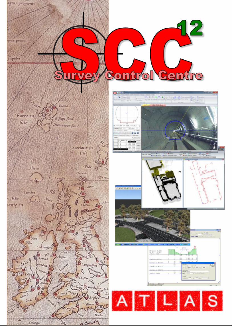
SCC is a comprehensive geomatics solution for the modern survey office, supporting data collection, reduction, and adjustment, through modelling, point cloud analysis, sections, volumes, design, to drawing production, 3d visualisation, setting out and quality assurance. Available for native 64 and 32 bit Windows 7, 8 and 10, SCC can handle the most demanding of jobs including multi-billion point clouds, and TIN models with hundreds of millions of triangles, with a huge range of industry specific tools for rail, roads, power lines, tree surveys, buildings and rivers as well as traditional topographic survey.Benefits
Maximum 'Field to Finish' Productivity SCC has been specifically designed to provide the highest level of automation required by the modern survey office while meeting the most demanding cartographic and modeling standards of the modern survey client for topography, sections, volumes, design, roads, rivers and rail.
Small learning curve Support for a wide range of existing field practices and coding standards. Fast, streamlined, modelling, analysis and drawing production. Highly customisable report generation with rich content via Crystal reports, including your company logo and contact details on all reports.
User friendly Standard Windows user interface with extensive online tutorials, help, web and local telephone support. Shared remote desktop based support also available for all users with an internet connection.
Compatibility Supports all major instruments, including Scanners, Total Stations, GPS, and survey data loggers, from all major manufacturers, including Leica Captivate and Viva, Trimble (including Trimble Link Engine), Sokkia, Topcon, and Nikon, using a wide variety of possible field coding techniques.
High Speed Exceptionally fast terrain modelling, contour generation, sectioning and surface analysis. Support for multi-million point models and multi-billion point clouds on low cost PCs.
Interoperability SCC services AutoCAD, Microstation, MX, ESRI and Google Earth with a minimum learning requirement. Bi-directional transfer of data in most modern standards including DWG, DGN, LandXML, SHP, 3DS, MX GENIO, and NRG, as well as support for legacy formats such as Panterra PXT, LandScape, and SDRmap. Support for a range of grids including Irish Grid, ITM, OSGB, and ETRS89 with optional support for SnakeGrids. Export to IFC for input into BIM.
Quality Assurance SCC includes a wide range of tools for checking surveys, comparing model revisions and analysing survey quality to user defined standards. All errors and reports are stored in separate files for subsequent checking, verifying and validation in QA procedures.
Input of survey, control, levelling, tunnelling and GIS data and output of setting out, design and models to and from data loggers, total stations, GPS, machine control, & scanners including Leica (DBX, HeXML, SDB and GSI), Trimble (DC, JXL, Geodimeter and SCS900), Amberg (GRP & AR2), ScanLaser, Topcon, Sokkia, MDL, Nikon and Pentax Support for multiple field survey coding standards across supported loggers including PocketDTM, MX, LandScape, NRG, TDS, TopSurv, TSCE and SDRmap
User definable 2D and 3D (7 parameter) transformations, to allow you to work in multiple grid systems, without having to re-edit your survey or models. Tools to move data between national and geodetic grid systems including Irish Grid, ITM, OSGB, and ETRS89 using in-built Grid Inquest based functionality. Optional support for SnakeGrid transformations. Streamlined integration with Leica Captivate for easy, efficient and comprehensive field to finish
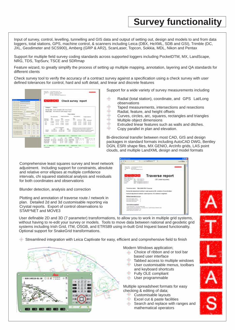
Comprehensive least squares survey and level network adjustment. Including support for constraints, absolute and relative error ellipses at multiple confidence intervals, chi squared statistical analysis and residuals for both coordinates and observations Blunder detection, analysis and correction Plotting and annotation of traverse route / network in plan. Detailed 2d and 3d customisable reporting via Crystal reports. Export of control observations to STAR*NET and MOVE3
Support for a wide variety of survey measurements including
Radial (total station), coordinate, and GPS Lat/Long observationsTaped measurements, intersections and resectionsRadial, feature, and height offsetsCurves, circles, arc, squares, rectangles and trianglesMultiple object dimensionsExtruded linear features such as walls and ditches.Copy parallel in plan and elevation.
Bi-directional transfer between most CAD, GIS and design packages in standard formats including AutoCAD DWG, Bentley DGN, ESRI shape files, MX GENIO, ArcInfo grids, LAS point clouds, and multiple LandXML design and model formats
Check survey tool to verify the accuracy of a contract survey against a specification using a check survey with user defined tolerances for control, hard and soft detail, and linear and discrete features
Feature wizard, to greatly simplify the process of setting up multiple mapping, annotation, layering and QA standards for different clients
Survey functionality
Modern Windows application;Choice of ribbon and or tool bar
based user interface Tabbed access to multiple windows
User customisable menus, toolbars and keyboard shortcutsFully OLE compliantUser programmable
Multiple spreadsheet formats for easy checking & editing of data;
Customisable layoutsExcel cut & paste facilitiesSearch and replace with ranges and mathematical operators
Extensive graphical model editing functionality with 'on the fly' model and contour updating and full 3D support across all tools including editing in plan, elevation and user defined viewports
Trim, Extend, Fillet and Join strings in 2D and 3DMove, Copy, rotate, scale and parallel strings or selected data.Enter tape measurement, bearing and distance measurements.Generate slope lines / hachures from existing stringsSingle, multi-point and best fit arc / circle / rectangle generationMeasure lines / areas / triangles / slopes / intersection / bisection / resectionExtensive symbol and complex line style creation / insertion and editing
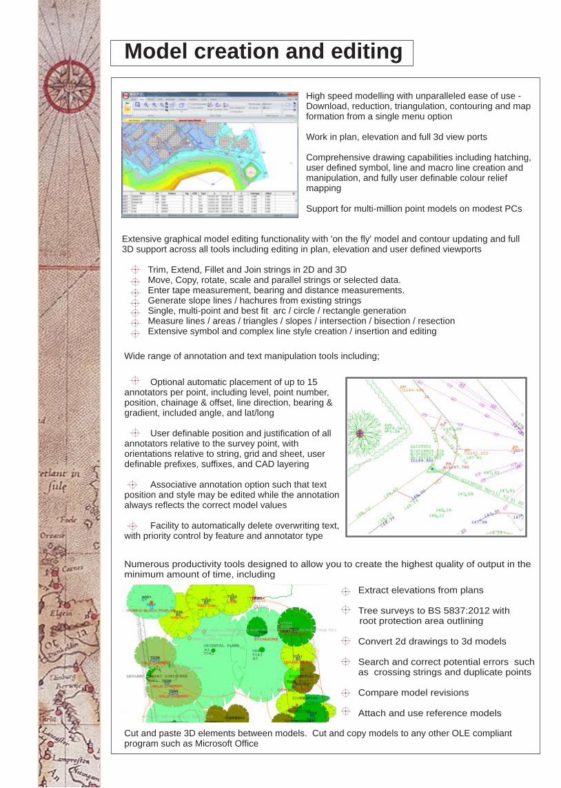
Wide range of annotation and text manipulation tools including;
Optional automatic placement of up to 15 annotators per point, including level, point number, position, chainage & offset, line direction, bearing & gradient, included angle, and lat/long
User definable position and justification of all annotators relative to the survey point, with orientations relative to string, grid and sheet, user definable prefixes, suffixes, and CAD layering
Associative annotation option such that text position and style may be edited while the annotation always reflects the correct model values
Facility to automatically delete overwriting text, with priority control by feature and annotator type
Cut and paste 3D elements between models. Cut and copy models to any other OLE compliant program such as Microsoft Office
Model creation and editing
High speed modelling with unparalleled ease of use - Download, reduction, triangulation, contouring and map formation from a single menu option Work in plan, elevation and full 3d view ports Comprehensive drawing capabilities including hatching, user defined symbol, line and macro line creation and manipulation, and fully user definable colour relief mapping Support for multi-million point models on modest PCs
Extract elevations from plans
Tree surveys to BS 5837:2012 with root protection area outlining
Convert 2d drawings to 3d models
Search and correct potential errors such as crossing strings and duplicate points
Compare model revisions
Attach and use reference models
Numerous productivity tools designed to allow you to create the highest quality of output in the minimum amount of time, including
Real time section and profile creation using split screen section and model view. Attach cross sections to plans and annotate with chainage, offset and section details Full bi-directional link to most popular CAD and design packages, including AutoCAD, Microstation, MOSS / MX, InRoads, and Civil3D for models, sections and alignments and import from SC0. User defined export of sections and models to text files and customisable Crystal reports
Sections and profiles
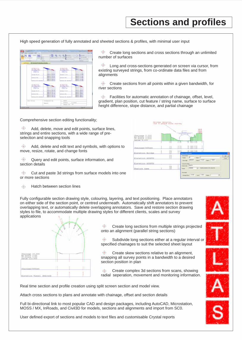
Create long sections and cross sections through an unlimited number of surfaces
Long and cross-sections generated on screen via cursor, from existing surveyed strings, from co-ordinate data files and from alignments
Create sections from all points within a given bandwidth, for river sections
Facilities for automatic annotation of chainage, offset, level, gradient, plan position, cut feature / string name, surface to surface height difference, slope distance, and partial chainage
High speed generation of fully annotated and sheeted sections & profiles, with minimal user input
Fully configurable section drawing style, colouring, layering, and text positioning. Place annotators on either side of the section point, or centred underneath. Automatically shift annotators to prevent overlapping text, or automatically delete overlapping annotators. Save and restore section drawing styles to file, to accommodate multiple drawing styles for different clients, scales and survey applications
Comprehensive section editing functionality;
Add, delete, move and edit points, surface lines, strings and entire sections, with a wide range of pre-selection and snapping tools
Add, delete and edit text and symbols, with options to move, resize, rotate, and change fonts
Query and edit points, surface information, and section details
Cut and paste 3d strings from surface models into one or more sections
Hatch between section lines
Create long sections from multiple strings projected onto an alignment (parallel string sections)
Subdivide long sections either at a regular interval or specified chainages to suit the selected sheet layout
Create skew sections relative to an alignment, snapping all survey points in a bandwidth to a desired section position in plan
Create complex 3d sections from scans, showing radial seperation, movement and monitoring information.
Areas and volumes
Support for multiple fully interactive sheet views in models and sections
Works with all Windows compatible plotters and printers, with full print preview
Support for placement of grids, scales, station coordinate tables, feature keys, bitmapped company logos and text macros
Support for multiple skewed grids to optimise paper usage
Plotting
Extensive sheet design facilities for creating, editing and plotting. Create your sheet layouts in SCC using all available editing facilities or import them from CAD
Support for all standard and user definable paper sizes. Export multiple scaled sheets to CAD
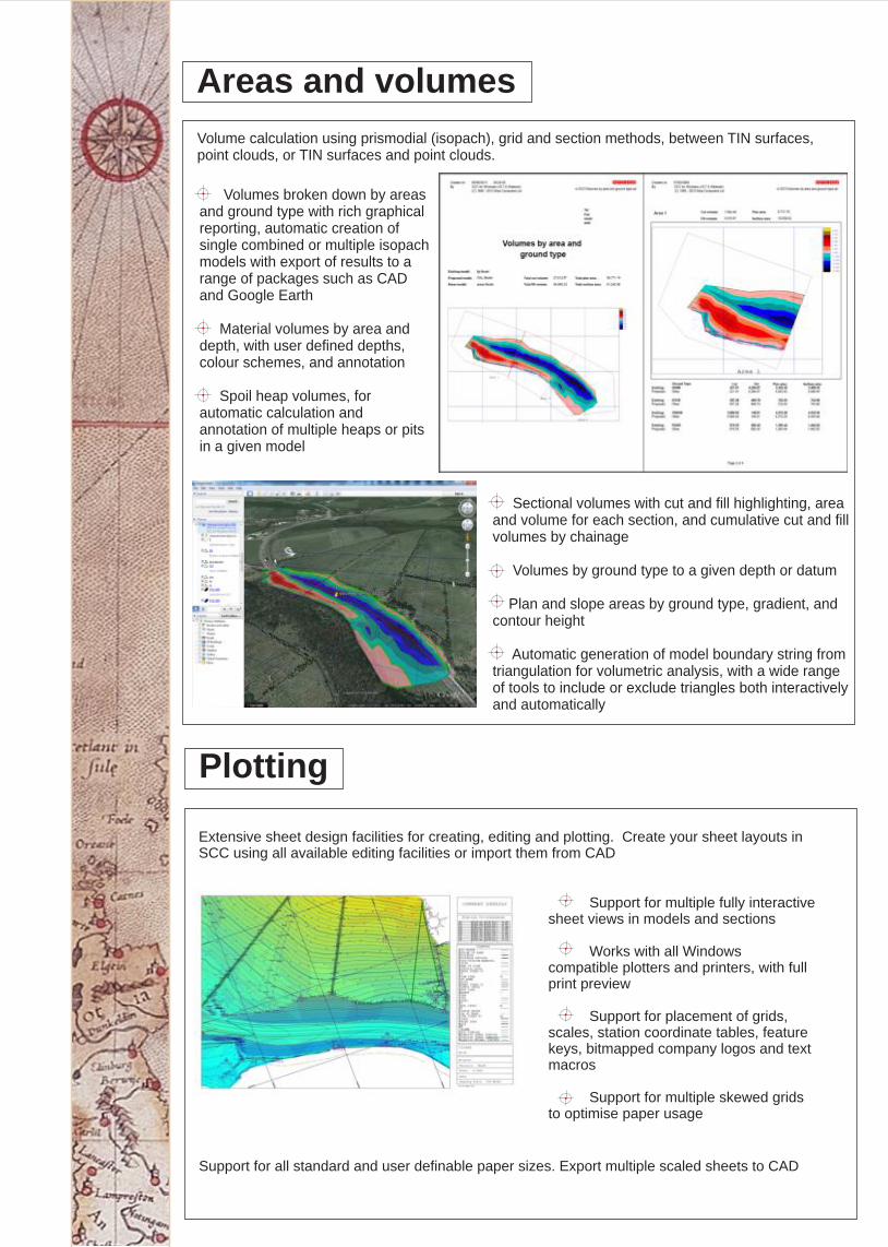
Volume calculation using prismodial (isopach), grid and section methods, between TIN surfaces, point clouds, or TIN surfaces and point clouds.
Sectional volumes with cut and fill highlighting, area and volume for each section, and cumulative cut and fill volumes by chainage Volumes by ground type to a given depth or datum Plan and slope areas by ground type, gradient, and contour height Automatic generation of model boundary string from triangulation for volumetric analysis, with a wide range of tools to include or exclude triangles both interactively and automatically
Volumes broken down by areas and ground type with rich graphical reporting, automatic creation of single combined or multiple isopach models with export of results to a range of packages such as CAD and Google Earth Material volumes by area and depth, with user defined depths, colour schemes, and annotation Spoil heap volumes, for automatic calculation and annotation of multiple heaps or pits in a given model
Point clouds
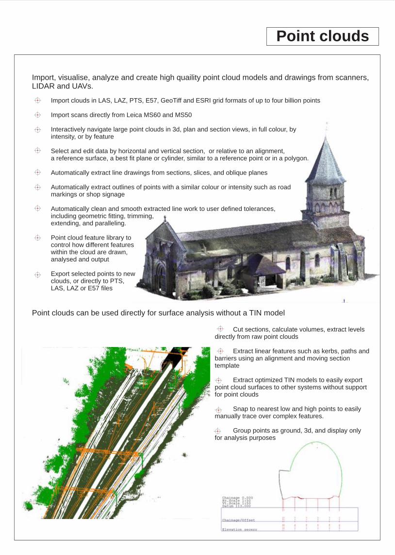
Import, visualise, analyze and create high quaility point cloud models and drawings from scanners, LIDAR and UAVs.
Cut sections, calculate volumes, extract levels directly from raw point clouds
Extract linear features such as kerbs, paths and barriers using an alignment and moving section template
Extract optimized TIN models to easily export point cloud surfaces to other systems without support for point clouds
Snap to nearest low and high points to easily manually trace over complex features.
Group points as ground, 3d, and display only for analysis purposes
Import clouds in LAS, LAZ, PTS, E57, GeoTiff and ESRI grid formats of up to four billion points
Import scans directly from Leica MS60 and MS50
Interactively navigate large point clouds in 3d, plan and section views, in full colour, by intensity, or by feature
Select and edit data by horizontal and vertical section, or relative to an alignment, a reference surface, a best fit plane or cylinder, similar to a reference point or in a polygon.
Automatically extract line drawings from sections, slices, and oblique planes
Automatically extract outlines of points with a similar colour or intensity such as road markings or shop signage
Automatically clean and smooth extracted line work to user defined tolerances, including geometric fitting, trimming, extending, and paralleling.
Point cloud feature library tocontrol how different featureswithin the cloud are drawn, analysed and output
Export selected points to newclouds, or directly to PTS, LAS, LAZ or E57 files
Point clouds can be used directly for surface analysis without a TIN model
Visual intrusion analysis (ZVI), ideal for environmental impact studies Highlight all the areas in a model where specific objects are visible or hidden from the ground or a specific viewer height above the ground. Remove 'noise' from scanned data, such as removing cars when processing a scanned road surface Optimize large models and massively reduce their size while preserving accuracy
Design
Volume optimisation functions including cut and fill balancing, and section optimisation to minimise cut Many string design tools including setting gradient between points and along strings for drainage purposes, create offset strings from existing strings based on an alignment copy parallel to existing strings to extend existing variable side slopes Export of geometric information to supported loggers, machine control systems and roading programs Merge survey and design models for visualisation and analysis purposes Comprehensive access to design chainage / offset system for modelling and spreadsheet functions, including extraction of sub-models and data sets by chainage / offset range
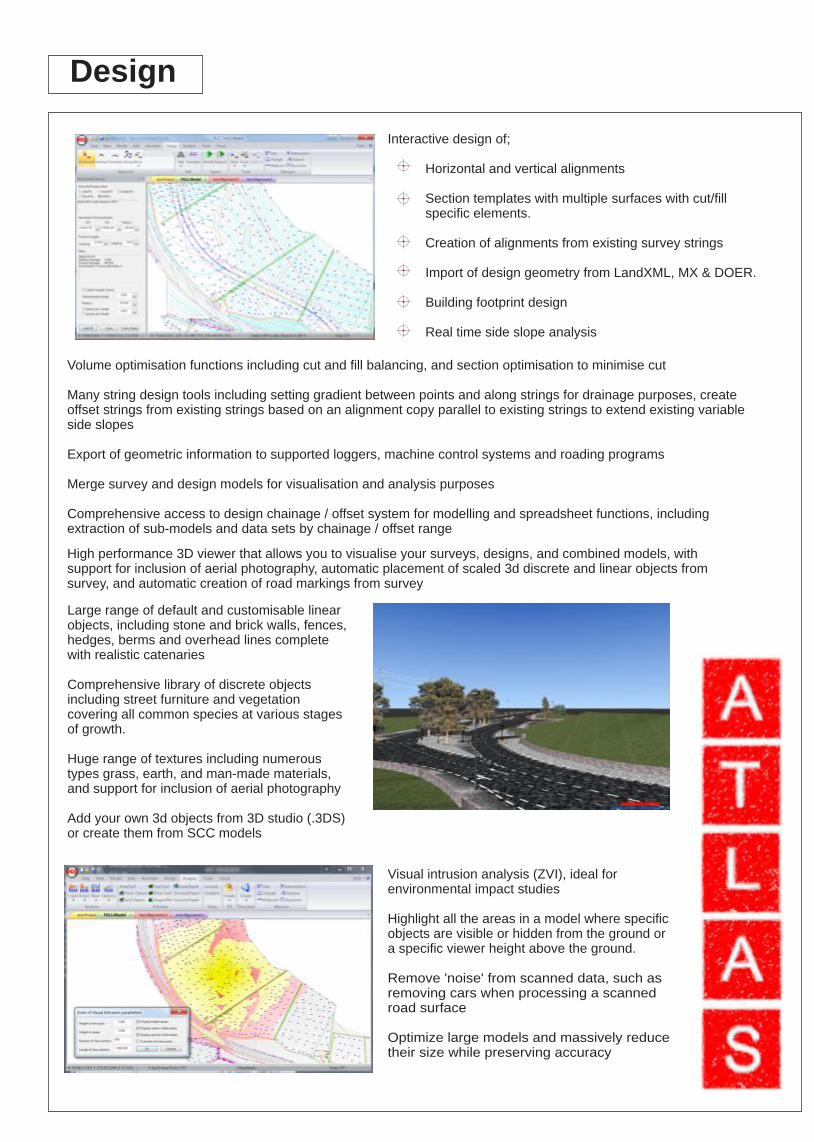
Interactive design of;
Horizontal and vertical alignments
Section templates with multiple surfaces with cut/fill specific elements.
Creation of alignments from existing survey strings
Import of design geometry from LandXML, MX & DOER.
Building footprint design
Real time side slope analysis
Large range of default and customisable linear objects, including stone and brick walls, fences, hedges, berms and overhead lines complete with realistic catenaries Comprehensive library of discrete objects including street furniture and vegetation covering all common species at various stages of growth. Huge range of textures including numerous types grass, earth, and man-made materials, and support for inclusion of aerial photography Add your own 3d objects from 3D studio (.3DS) or create them from SCC models
High performance 3D viewer that allows you to visualise your surveys, designs, and combined models, with support for inclusion of aerial photography, automatic placement of scaled 3d discrete and linear objects from survey, and automatic creation of road markings from survey
Rail surveying
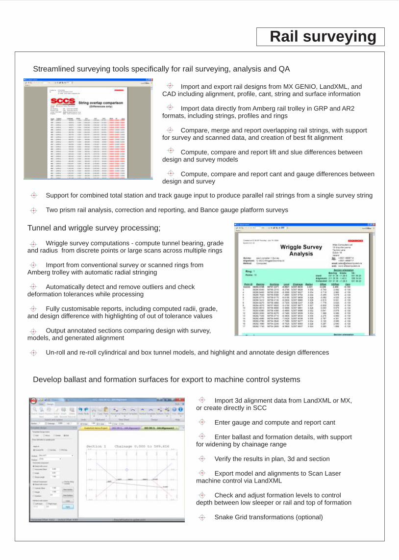
Import and export rail designs from MX GENIO, LandXML, and CAD including alignment, profile, cant, string and surface information
Import data directly from Amberg rail trolley in GRP and AR2 formats, including strings, profiles and rings
Compare, merge and report overlapping rail strings, with support for survey and scanned data, and creation of best fit alignment
Compute, compare and report lift and slue differences between design and survey models
Compute, compare and report cant and gauge differences between design and survey
Streamlined surveying tools specifically for rail surveying, analysis and QA
Develop ballast and formation surfaces for export to machine control systems
Tunnel and wriggle survey processing;
Wriggle survey computations - compute tunnel bearing, grade and radius from discrete points or large scans across multiple rings
Import from conventional survey or scanned rings from Amberg trolley with automatic radial stringing
Automatically detect and remove outliers and check deformation tolerances while processing
Fully customisable reports, including computed radii, grade, and design difference with highlighting of out of tolerance values
Output annotated sections comparing design with survey, models, and generated alignment
Un-roll and re-roll cylindrical and box tunnel models, and highlight and annotate design differences
Import 3d alignment data from LandXML or MX, or create directly in SCC
Enter gauge and compute and report cant
Enter ballast and formation details, with support for widening by chainage range
Verify the results in plan, 3d and section
Export model and alignments to Scan Laser machine control via LandXML
Check and adjust formation levels to control depth between low sleeper or rail and top of formation
Snake Grid transformations (optional)
Support for combined total station and track gauge input to produce parallel rail strings from a single survey string
Two prism rail analysis, correction and reporting, and Bance gauge platform surveys
Rivers, drainage and beaches
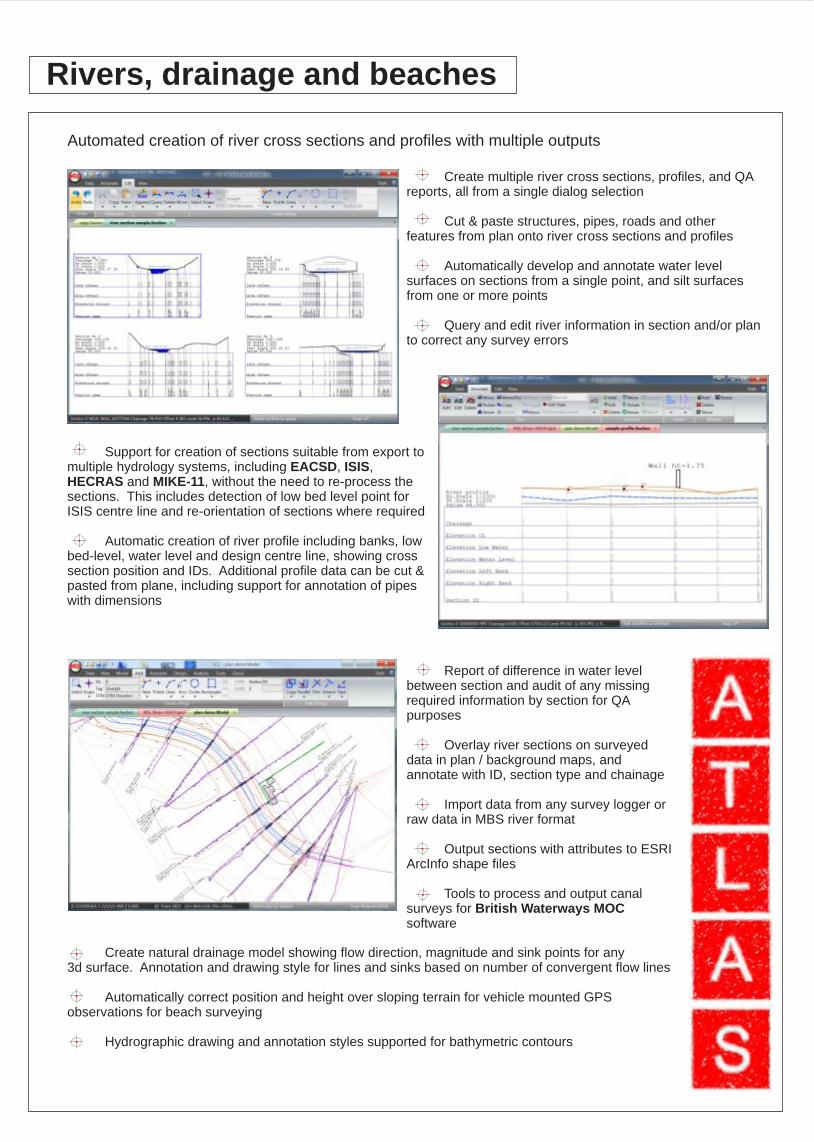
Create multiple river cross sections, profiles, and QA reports, all from a single dialog selection
Cut & paste structures, pipes, roads and other features from plan onto river cross sections and profiles
Automatically develop and annotate water level surfaces on sections from a single point, and silt surfaces from one or more points
Query and edit river information in section and/or plan to correct any survey errors
Automated creation of river cross sections and profiles with multiple outputs
Support for creation of sections suitable from export to multiple hydrology systems, including EACSD, ISIS, HECRAS and MIKE-11, without the need to re-process the sections. This includes detection of low bed level point for ISIS centre line and re-orientation of sections where required
Automatic creation of river profile including banks, low bed-level, water level and design centre line, showing cross section position and IDs. Additional profile data can be cut & pasted from plane, including support for annotation of pipes with dimensions
Report of difference in water level between section and audit of any missing required information by section for QA purposes
Overlay river sections on surveyed data in plan / background maps, and annotate with ID, section type and chainage
Import data from any survey logger or raw data in MBS river format
Output sections with attributes to ESRI ArcInfo shape files
Tools to process and output canal surveys for British Waterways MOC software
Create natural drainage model showing flow direction, magnitude and sink points for any 3d surface. Annotation and drawing style for lines and sinks based on number of convergent flow lines
Automatically correct position and height over sloping terrain for vehicle mounted GPS
observations for beach surveying
Hydrographic drawing and annotation styles supported for bathymetric contours
Installation
To install SCC, insert the DVD in your DVD drive and run the 'Setup' application on that drive, making sure you have administrator privileges. For example, if your CD drive is drive 'D', open an explorer window, navigate to Computer / Local disk (D:), right click on the Setup icon, and select Run as Administrator. To use SCC, you will need a USB hardware lock, network license or node locked license following the SCC installation. To use a USB hardware lock, insert the lock into an available USB port prior to starting the installation procedure. If you are installing without a USB key or network license, you will be given the option to request a trial license, either via email or fax. The first option sends an email request directly from SCC, the latter option places the same information in a text file you can send manually. Once we've received this license request, We'll send a license key (either viewer only, demo or timed) by return email. If you have a previous version of SCC installed, please back up all your SCC data, and uninstall the previous version prior to installing this version. If you need any help with installation, phone Atlas support at +353 (1) 4958714 or email [email protected] Note that you cannot upgrade to a newer version of SCC without a current maintenance agreement, and the software will not work if you attempt to do so. Once you have installed SCC, please go to http://www.atlascomputers.ie/smf/index.php to register an account on our user forum. Once registered you will automatically be notified by email of any on-going updates to the SCC software, and provided with links to download new versions. We also have a Linked-In forum for SCC users, which may also be used to receive notifications of any updates, see http://www.linkedin.com/groups/SCC-users-4971870

A. E. Faulks, Abbey Holford Rowe, Access Building Design, Acute Engineering Surveys, Adenstar Construction, Adept Consulting Engineers Limited, ADS, Aer Rianta Technical, Aer Rianta Technical Services, AG Surveys, AH Leech Son & Dean, Alfred McAlpine, Allister Mansworth Limited, An Garda Siochana, Anglia Land Surveys, Apex Surveys, Arc Architectural Consultants, Arcadis, Gerraghty & Miller, Archeological Services Ltd, Architectural Planning Service, Arthur Waddell, ASEC Corporation, Ashbridge Construction Ltd, Astasoft, Athlone Institute of Technology, Atkins Benham, Atkins McCarthy, Axis (Groundworks Southeast), Aztec Land Surveys, Babtie Group, Balfour Beatty Rail Projects Ltd., Ballyvoughan Design, Banner Surveys, Barber Aitkins, Baseline Surveying Services, Bayindir Insaat Tunizm, Bechtell International Inc, Belfast City Council, Bennett Land Surveys Ltd, Bentley Systems, Bernard Fitzpatrick & Associates, Bernardin Lochmueller & Assoc, Billam Contractors, Birla International Marketing Corporatio, BKS Surveys, Blackburn B.C., Blast Design International, Inc, Bolton Metro, Boreham Consulting Engineers, Bouwtechnisch Tekenburo - Holland, Bowmer and Kirkland, Bradley, Lynch & Associates, Brendan Ryan, Breslin Carr, Bridgeway Consulting Ltd, Britannia Construction, British Rail South East, Bruceshaw Partnership, Butler, Fairman & Seufert, Cafferkey Developments, Canterbury College, Cardinal Engineering Services, Carlow Co Co, Carlow I.T, Cavan Co. Co., Cerberus, Cheshire County Council, Chester-le-Street DC, Chesterfield College, City of Liverpool, Civil Engineering Surveys, Clare Civil Engineering Limited, Clare Co. Co., Cleanaway Ltd, Clifton Scannell Emerson Associates, Clonmel Bypass, Coffey Construction, Coffey Plant Ltd, Cole Associates Inc, Colin Bray, Complete Contract Management, Conia Cms Limited, Conwy C C, Coras Iompair Eireann, Cork Co Co, Cork Corporation, Cork Institute of Technology, Cork RTC, Corporation of Sligo, Costello Lomansey, COWI A/S, Cranfield University Royal Military College, Cumbrian Industrials Ltd, D.R.A. U.K., David McCormack Architects, DC Site Services, DCCS Ltd, Delyn Borough Council, Department of Arts, Heritage, Gealtacht, Derby Co. Co., Derek Skeats Associates, Diatec Solutions, DIT, Bolton St, DOE NI, Doncaster MBC, Donegal Co. Co., DTI, Dublin Corporation, Dublin Light Rail, Duchas, Dundalk Urban District Council, Dunlaoghaire Rathdown Co. Co., DVP Geomatic Private Limited, Eamonn Hendrick, Earewash Contracting, East Sussex Co. Co. Survey Section Estat, EGS Systems, EMS Consulting Limited, Enda Jones, Enrol, Teeside Operations Ltd, ESB Distribution, ESBI, Estudios Y Soluciones Informaticas de In, European Air Surveys/Digitech 3D, Evergreen Productions Ltd, EXCORP, Explo-Tech, Fairways Course Guides, Fanning Contracting, Fehily Timoney & Company, Fergal Geoghegan Civil Engineer, Fingal Co. Co., Fisheries Rearch Centre, FLI Environmental, Flintshire Co. Co., Forensic Science Northern Ireland, Formby Surveys, Fox Contracts, G. Osbourne Ltd, Gallaghers, Galliford Midlands, Galway County Council, Galway RTC(Galway-Mayo Institute of Tech, Garner Surveys Ltd, Gateshead MBC, Geoffrey Walton, Geoid d.o.o Rijeka, Geometius bv, Gibson Bainbridge Ltd, GlenCarr, GMA - Tubin Construction Ltd Ireland, GP Co. Ltd, GPS surveys, Graham Engineering Surveys, Graham/Uniform JV, Greenhorne and O'Mara, Guildford College, Gwynedd Archeological Trust, Halcrow Group Limited, Hampshire Co. Co., Harrison, Hempenstall Survey & Scientific Instrume, HMG & Associates(Architects), Holden Transportation Engineering, Hollins Architects & Surveyors, Hong Kong Highways, Howley Civil Engineering Ltd, IANH, IETG, Imvec, Indiana DOT, Informatik, InfraCAD Solutions, Ing. H.M. RUUD, Institute of Technology, Carlow, Instituto Politecico de Braganca, Intercontinental Consultants and Technor, Invar Mapping, Irish Enco, Irish Engineering Surveys/Geomap Ltd, Irish Rail, J & L Surveys, J N Bentley Ltd, J.T. Gibbons & Associates, Jackson Civil Engineering, James O Hara, Jarvis Rail, JD Surveys, Joe Houlton, Joe O'Toole, John B Akroyd Excavations, John Gilchrest, John J O Sullivan, John Martin Construction., John Mooney & Co Ltd, John Paul Construction, John Sisk & Son, Jurukur Esa, Ken Moorhead Excavations Ltd, Kennedy Quarries, Kent Co. Co., Kildare Co Co, Kilkenny Co. Co., Kirk McClure Morton, KND Surveys, Kyst-Inspektoratet, Lagan Asphalt, Lakes Engineering Ltd, Lancashire Waste Services Ltd, Laois Co. Co., Laser and Survey Solutions Pty Ltd, Leitrim Co. Co., Leslie Mae, Limerick County Council, Line Surveys Ltd, Loach Construction, Location Surveys, Longford Co. Co., Louth County Council, Loy Surveys, Lybian Consultancy, Maine DOT, Malcom Hughes Land Surveys, Manchester Polytechnic, Mansell, Maptech Surveys, Marine Micro Systems, Marteam Ltd, Martin Engineering Servies, Mathias Reidy & Associates, Maunsell Consultancy Services, Mc Donald Survey Ltd, McAlister Surveys, McCarthy & Partners, McMenamin Leadley, McPhilips (Wellington) Ltd, MDL, Meath Co. Co., Meridian Land Surveys, MGM Civil Engineering Services, Michael O Toole, Mid Lothian Council, Military Works Force, Mining & Planning Surveys (Pakistan), Ministry of Railways Design (Institution, Minorco Lisheen, Monaghan County Council, MRKHEF, MSE Corporation, MTC Surveys (Mustafawi Trading & Engineering, Murphy & Co., Murphy International on behalf of Bord G, MWH Programme Management Ltd, N.A.V.O. U.S., National Highway of Sudan, Nationwide Surveys, ND Oliver & Co, New Hampshire DOT, Newcastle City Council, Niall Fanning, NIIT Limited, Norconsult, North Brook College, North Cork Surveys, North Surveys Pty Ltd - Australia, North Tyneside Co. Co., North West Engineering Services, Northern Track Renewals, Northumberland County Council, Northumbrian Water, Norwich City Council, Nottingham Contracting, Nottinghamshire Co. Co., O Connor Sutton Cronin Civil/Structural, O'Reilly Stewart & Associates, October House Design, Offaly Co. Co., Office of Public Works, Owen Williams Consultants, P J Survey LTD, P.J. Walls (Mullingar Bypass), Parsons Brinkerhoff/Tudor, Pat Mulcair, Paul Corrigan & Associates, Paul Cripe Inc, Peter O Loughlin Ltd, Phillip Fay, PJ Careys, PJ Hegarty & sons, PJ Tobin & Co, Planet Survey Services, Post Buckley Schuh & Jernigan, Provincie Noord-Brabant, Precision Response Corporation, PSBS, Public Works, Nigeria, Quarrytec Incorporated, Racheal Morduff, Railway Procurement Agency, Ray Doran, Ray Keane & Associates, Ray O'Grady, RBJ Mining (UK) Ltd, Red Lodge Homes Limited, Roadbridge Limited, Roadstone Provinces Ltd, Robert Brett & Sons Ltd, Rockmate Technical Services, Roland Tarrant, Roscommon Co. Co., Royal School of Military Engineering, RPS-MCOS Ltd., S.M. Morris, Salford University, Satellite Goldfields Ltd, Schneider Engineering Corp, Seamus McLarnon, Sean Quinn Group, Setting Out Services (SOS), Shane Joyce, Sheehan Land Surveys, Sheffield City Council, Sheridan & Lynch Ltd, SIAC Construction, Silent Valley Waste Services Ltd, Skanska Construction, SLC Associates, Sligo Borough Council, Sligo Co. Co., Sligo Institute of Technology, Sorensen Civil Engineering Ltd, South Dublin County Council, South East Surveys, Southern Track Renewal Unit, Spain Courtney Doyle, Steanne Solutions, Stirling Co. Co., Suffolk Co. Co., Survey and Design Services, Survey Operations, Survey Seven, Survey Systems Ltd, Symos, T.A. Lacey, TAL Limited, Tara Mines, Tarmac Construction, Tayside Regional Council (Angus Council), Technical Solutions Ltd, TEDI South, Telford & Wrekin DC, Teorema s.r.l. - Topcenter, The Civil Engineering Centre, The Morris Sisk Consortium, Tipperarry Co. Co. (South Riding), Tom Gleeson, Topometrica, Lda., TRAGSA, Tramore House Regional Design Office, Trinity College Dublin, UKANDIS, Ukurarah Consultants, Uniform Construction, United Surveying Inc, University College Cork, University of Sussex, University of West England, Vodafone, Walter Buchanan, Wasson Ltd, Waterford City Council, Waterford Co. Co., Waterford Corporation, Waterford NRA, Waterways Ireland, Watts Contracting, Welsh Office, Westmeath Co. Co., Wexford Co. Co., Wicklow Co Co, William Reid, Wills Bros Limited, Wills Bros Plant Hire Ltd, Wm A. Moyles Planning and Engineering Con, WS Atkins
Mapping Section
SCC is used in a variety of companies, ranging from small land survey companies to large international consultancies in the public and private sector with thousands of licenses deployed across many hundreds of organisations. SCC has been in continuous development since 1990 and enjoys an extensive user base in Ireland and the UK, Europe, the Middle East, and the rest of the world. A small sample of our clients are highlighted below.
Who uses SCC ?
Atlas Computers Ltd15 Moyville LawnsTaylors Lane Rathfarnham, Dublin 16Republic of Ireland
Ph: + 353(0)1 4958714 (Irl)+44 (0)2075588973 (UK) Fax: + 353(0)1 4958717www.atlascomputers.ie
Fugro-BKS
Tel: 01480 404888Fax: 01480 404333
hq1 BuildingEaton Socon,CambridgeshirePE19 8EP