Embed Size (px)
Citation preview
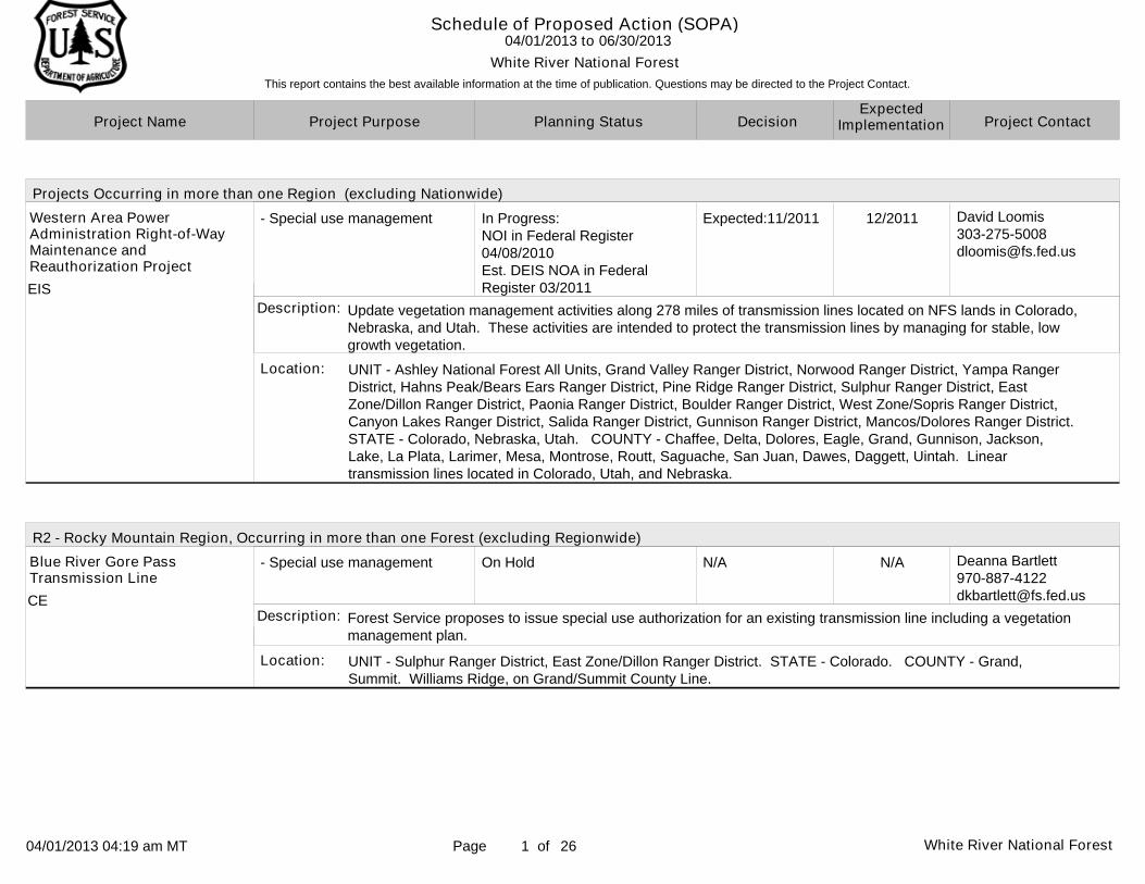
04/01/2013 04:19 am MT Page of1 White River National Forest 26
Projects Occurring in more than one Region (excluding Nationwide)
R2 - Rocky Mountain Region, Occurring in more than one Forest (excluding Regionwide)
This report contains the best available information at the time of publication. Questions may be directed to the Project Contact.
Project PurposeProject Name DecisionPlanning Status Project ContactExpected
Implementation
04/01/2013 to 06/30/2013
- Special use management
- Special use management
In Progress:NOI in Federal Register 04/08/2010Est. DEIS NOA in Federal Register 03/2011
On Hold
Expected:11/2011
N/A
David [email protected]
Deanna [email protected]
UNIT - Ashley National Forest All Units, Grand Valley Ranger District, Norwood Ranger District, Yampa Ranger District, Hahns Peak/Bears Ears Ranger District, Pine Ridge Ranger District, Sulphur Ranger District, East Zone/Dillon Ranger District, Paonia Ranger District, Boulder Ranger District, West Zone/Sopris Ranger District, Canyon Lakes Ranger District, Salida Ranger District, Gunnison Ranger District, Mancos/Dolores Ranger District. STATE - Colorado, Nebraska, Utah. COUNTY - Chaffee, Delta, Dolores, Eagle, Grand, Gunnison, Jackson, Lake, La Plata, Larimer, Mesa, Montrose, Routt, Saguache, San Juan, Dawes, Daggett, Uintah. Linear transmission lines located in Colorado, Utah, and Nebraska.
UNIT - Sulphur Ranger District, East Zone/Dillon Ranger District. STATE - Colorado. COUNTY - Grand, Summit. Williams Ridge, on Grand/Summit County Line.
Location:
Location:
12/2011
N/A
Western Area Power Administration Right-of-Way Maintenance and Reauthorization Project
Blue River Gore Pass Transmission Line
Schedule of Proposed Action (SOPA)
Update vegetation management activities along 278 miles of transmission lines located on NFS lands in Colorado, Nebraska, and Utah. These activities are intended to protect the transmission lines by managing for stable, low growth vegetation.
Forest Service proposes to issue special use authorization for an existing transmission line including a vegetation management plan.
Description:
Description:
White River National Forest
EIS
CE
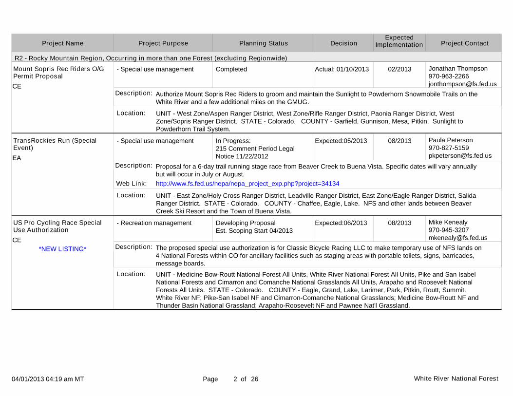
04/01/2013 04:19 am MT Page of2 White River National Forest 26
R2 - Rocky Mountain Region, Occurring in more than one Forest (excluding Regionwide)
Project PurposeProject Name DecisionPlanning Status Project ContactExpected
Implementation
- Special use management
- Special use management
- Recreation management
Completed
In Progress:215 Comment Period Legal Notice 11/22/2012
Developing ProposalEst. Scoping Start 04/2013
Actual: 01/10/2013
Expected:05/2013
Expected:06/2013
Jonathan [email protected]
Paula [email protected]
Mike [email protected]
UNIT - West Zone/Aspen Ranger District, West Zone/Rifle Ranger District, Paonia Ranger District, West Zone/Sopris Ranger District. STATE - Colorado. COUNTY - Garfield, Gunnison, Mesa, Pitkin. Sunlight to Powderhorn Trail System.
UNIT - East Zone/Holy Cross Ranger District, Leadville Ranger District, East Zone/Eagle Ranger District, Salida Ranger District. STATE - Colorado. COUNTY - Chaffee, Eagle, Lake. NFS and other lands between Beaver Creek Ski Resort and the Town of Buena Vista.
UNIT - Medicine Bow-Routt National Forest All Units, White River National Forest All Units, Pike and San Isabel National Forests and Cimarron and Comanche National Grasslands All Units, Arapaho and Roosevelt National Forests All Units. STATE - Colorado. COUNTY - Eagle, Grand, Lake, Larimer, Park, Pitkin, Routt, Summit. White River NF; Pike-San Isabel NF and Cimarron-Comanche National Grasslands; Medicine Bow-Routt NF andThunder Basin National Grassland; Arapaho-Roosevelt NF and Pawnee Nat'l Grassland.
Location:
Location:
Location:
02/2013
08/2013
08/2013
Mount Sopris Rec Riders O/G Permit Proposal
TransRockies Run (Special Event)
US Pro Cycling Race Special Use Authorization
Authorize Mount Sopris Rec Riders to groom and maintain the Sunlight to Powderhorn Snowmobile Trails on the White River and a few additional miles on the GMUG.
Proposal for a 6-day trail running stage race from Beaver Creek to Buena Vista. Specific dates will vary annually but will occur in July or August.
The proposed special use authorization is for Classic Bicycle Racing LLC to make temporary use of NFS lands on 4 National Forests within CO for ancillary facilities such as staging areas with portable toilets, signs, barricades, message boards.
Description:
Description:
Description:
Web Link: http://www.fs.fed.us/nepa/nepa_project_exp.php?project=34134
*NEW LISTING*
CE
EA
CE
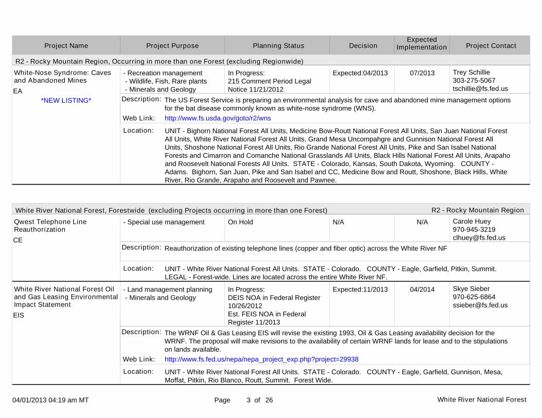
04/01/2013 04:19 am MT Page of3 White River National Forest 26
R2 - Rocky Mountain Region, Occurring in more than one Forest (excluding Regionwide)
White River National Forest, Forestwide (excluding Projects occurring in more than one Forest)
Project PurposeProject Name DecisionPlanning Status Project ContactExpected
Implementation
R2 - Rocky Mountain Region
- Recreation management - Wildlife, Fish, Rare plants - Minerals and Geology
- Special use management
- Land management planning - Minerals and Geology
In Progress:215 Comment Period Legal Notice 11/21/2012
On Hold
In Progress:DEIS NOA in Federal Register 10/26/2012Est. FEIS NOA in Federal Register 11/2013
Expected:04/2013
N/A
Expected:11/2013
Trey [email protected]
Carole [email protected]
Skye [email protected]
UNIT - Bighorn National Forest All Units, Medicine Bow-Routt National Forest All Units, San Juan National ForestAll Units, White River National Forest All Units, Grand Mesa Uncompahgre and Gunnison National Forest All Units, Shoshone National Forest All Units, Rio Grande National Forest All Units, Pike and San Isabel National Forests and Cimarron and Comanche National Grasslands All Units, Black Hills National Forest All Units, Arapahoand Roosevelt National Forests All Units. STATE - Colorado, Kansas, South Dakota, Wyoming. COUNTY - Adams. Bighorn, San Juan, Pike and San Isabel and CC, Medicine Bow and Routt, Shoshone, Black Hills, White River, Rio Grande, Arapaho and Roosevelt and Pawnee.
UNIT - White River National Forest All Units. STATE - Colorado. COUNTY - Eagle, Garfield, Pitkin, Summit. LEGAL - Forest-wide. Lines are located across the entire White River NF.
UNIT - White River National Forest All Units. STATE - Colorado. COUNTY - Eagle, Garfield, Gunnison, Mesa, Moffat, Pitkin, Rio Blanco, Routt, Summit. Forest Wide.
Location:
Location:
Location:
07/2013
N/A
04/2014
White-Nose Syndrome: Caves and Abandoned Mines
Qwest Telephone Line Reauthorization
White River National Forest Oil and Gas Leasing EnvironmentalImpact Statement
The US Forest Service is preparing an environmental analysis for cave and abandoned mine management optionsfor the bat disease commonly known as white-nose syndrome (WNS).
Reauthorization of existing telephone lines (copper and fiber optic) across the White River NF
The WRNF Oil & Gas Leasing EIS will revise the existing 1993, Oil & Gas Leasing availability decision for the WRNF. The proposal will make revisions to the availability of certain WRNF lands for lease and to the stipulations on lands available.
Description:
Description:
Description:
Web Link:
Web Link:
http://www.fs.usda.gov/goto/r2/wns
http://www.fs.fed.us/nepa/nepa_project_exp.php?project=29938
*NEW LISTING*EA
CE
EIS
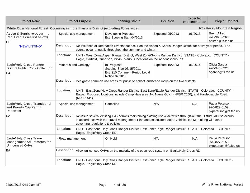
04/01/2013 04:19 am MT Page of4 White River National Forest 26
White River National Forest, Occurring in more than one District (excluding Forestwide)
Project PurposeProject Name DecisionPlanning Status Project ContactExpected
Implementation
R2 - Rocky Mountain Region
- Special use management
- Minerals and Geology
- Special use management
- Road management
Developing ProposalEst. Scoping Start 04/2013
In Progress:Scoping Start 03/15/2011Est. 215 Comment Period LegalNotice 07/2013
Cancelled
On Hold
Expected:05/2013
Expected:10/2013
N/A
N/A
Brent [email protected]
Olivia [email protected]
Paula [email protected]
Paula [email protected]
UNIT - West Zone/Aspen Ranger District, West Zone/Sopris Ranger District. STATE - Colorado. COUNTY - Eagle, Garfield, Gunnison, Pitkin. Various locations on the Aspen/Sopris RD.
UNIT - East Zone/Holy Cross Ranger District, East Zone/Eagle Ranger District. STATE - Colorado. COUNTY - Eagle. Proposed locations include Camp Hale area, No Name Gulch (NFSR 7050), and Hardscrabble Road (NFSR 441).
UNIT - East Zone/Holy Cross Ranger District, East Zone/Eagle Ranger District. STATE - Colorado. COUNTY - Eagle. Eagle/Holy Cross RD.
UNIT - East Zone/Holy Cross Ranger District, East Zone/Eagle Ranger District. STATE - Colorado. COUNTY - Eagle. Eagle/Holy Cross RD.
Location:
Location:
Location:
Location:
06/2013
06/2014
N/A
N/A
Aspen & Sopris re-occurring Rec. Events (see list below).
Eagle/Holy Cross Ranger District Public Rock Collection
Eagle/Holy Cross Transitional and Priority O/G Permit Renewals
Eagle/Holy Cross Travel Management Adjustments for Unlicensed OHVs
Re-issuance of Recreation Events that occur on the Aspen & Sopris Ranger District for a five year period. The events occur annually throughout the summer and winter.
Designate common use areas for public to collect landscape rocks on the two districts
Re-issue several existing O/G permits maintaining existing use & activities through-out the District. All use occurs in accordance with the Travel Management Plan and associated Motor Vehicle Use Map along with other governing regulations & policies.
Allow unlicensed OHVs on the majority of the open road system on Eagle/Holy Cross RD
Description:
Description:
Description:
Description:
*NEW LISTING*CE
EA
EA
EA
04/01/2013 04:19 am MT Page of5 White River National Forest 26
White River National Forest, Occurring in more than one District (excluding Forestwide)
Project PurposeProject Name DecisionPlanning Status Project ContactExpected
Implementation
R2 - Rocky Mountain Region
- Grazing management
- Special use management
- Special use management
- Special use management
On Hold
In Progress:215 Comment Period Legal Notice 03/13/2013
In Progress:Scoping Start 11/20/2012Est. 215 Comment Period LegalNotice 04/2013
In Progress:Scoping Start 01/10/2013Est. 215 Comment Period LegalNotice 04/2013
N/A
Expected:09/2013
Expected:09/2013
Expected:05/2013
Jessica [email protected]
Richard [email protected]
Bill [email protected]
Kyle [email protected]
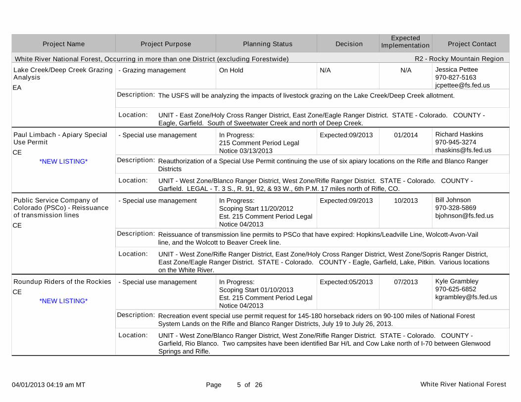
UNIT - East Zone/Holy Cross Ranger District, East Zone/Eagle Ranger District. STATE - Colorado. COUNTY - Eagle, Garfield. South of Sweetwater Creek and north of Deep Creek.
UNIT - West Zone/Blanco Ranger District, West Zone/Rifle Ranger District. STATE - Colorado. COUNTY - Garfield. LEGAL - T. 3 S., R. 91, 92, & 93 W., 6th P.M. 17 miles north of Rifle, CO.
UNIT - West Zone/Rifle Ranger District, East Zone/Holy Cross Ranger District, West Zone/Sopris Ranger District, East Zone/Eagle Ranger District. STATE - Colorado. COUNTY - Eagle, Garfield, Lake, Pitkin. Various locationson the White River.
UNIT - West Zone/Blanco Ranger District, West Zone/Rifle Ranger District. STATE - Colorado. COUNTY - Garfield, Rio Blanco. Two campsites have been identified Bar H/L and Cow Lake north of I-70 between GlenwoodSprings and Rifle.
Location:
Location:
Location:
Location:
N/A
01/2014
10/2013
07/2013
Lake Creek/Deep Creek GrazingAnalysis
Paul Limbach - Apiary Special Use Permit
Public Service Company of Colorado (PSCo) - Reissuance of transmission lines
Roundup Riders of the Rockies
The USFS will be analyzing the impacts of livestock grazing on the Lake Creek/Deep Creek allotment.
Reauthorization of a Special Use Permit continuing the use of six apiary locations on the Rifle and Blanco Ranger Districts
Reissuance of transmission line permits to PSCo that have expired: Hopkins/Leadville Line, Wolcott-Avon-Vail line, and the Wolcott to Beaver Creek line.
Recreation event special use permit request for 145-180 horseback riders on 90-100 miles of National Forest System Lands on the Rifle and Blanco Ranger Districts, July 19 to July 26, 2013.
Description:
Description:
Description:
Description:
*NEW LISTING*
*NEW LISTING*
EA
CE
CE
CE
04/01/2013 04:19 am MT Page of6 White River National Forest 26
White River National Forest East Zone/Dillon Ranger District (excluding Projects occurring in more than one District)
Project PurposeProject Name DecisionPlanning Status Project ContactExpected
Implementation
R2 - Rocky Mountain Region
- Special use management
- Special use management
- Special use management
- Land ownership management
Developing ProposalEst. Scoping Start 04/2013
Developing ProposalEst. Scoping Start 04/2013
Developing ProposalEst. NOI in Federal Register 05/2013
On Hold
Expected:10/2013
Expected:08/2013
Expected:11/2014
N/A
Paul [email protected]
Paul [email protected]
Shelly [email protected]
Kevin [email protected]
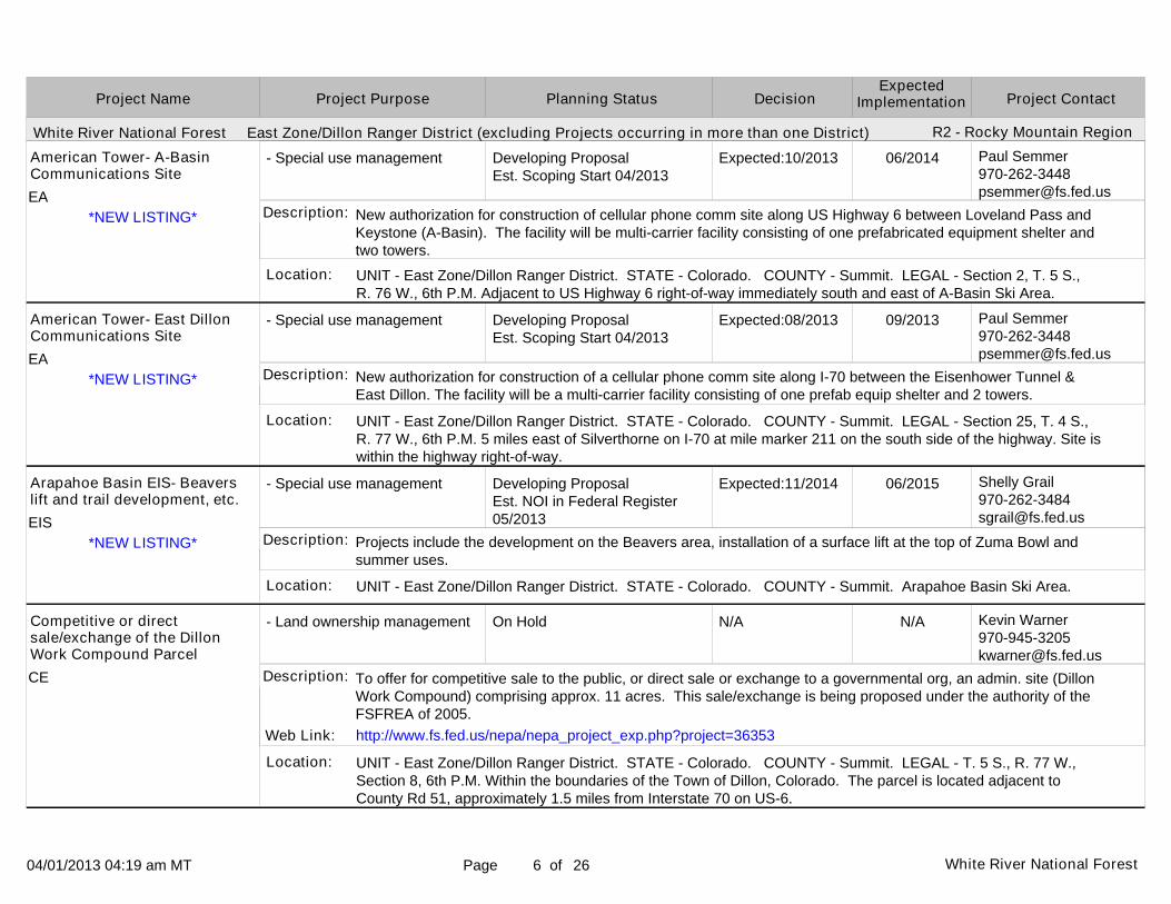
UNIT - East Zone/Dillon Ranger District. STATE - Colorado. COUNTY - Summit. LEGAL - Section 2, T. 5 S., R. 76 W., 6th P.M. Adjacent to US Highway 6 right-of-way immediately south and east of A-Basin Ski Area.
UNIT - East Zone/Dillon Ranger District. STATE - Colorado. COUNTY - Summit. LEGAL - Section 25, T. 4 S., R. 77 W., 6th P.M. 5 miles east of Silverthorne on I-70 at mile marker 211 on the south side of the highway. Site iswithin the highway right-of-way.
UNIT - East Zone/Dillon Ranger District. STATE - Colorado. COUNTY - Summit. Arapahoe Basin Ski Area.
UNIT - East Zone/Dillon Ranger District. STATE - Colorado. COUNTY - Summit. LEGAL - T. 5 S., R. 77 W., Section 8, 6th P.M. Within the boundaries of the Town of Dillon, Colorado. The parcel is located adjacent to County Rd 51, approximately 1.5 miles from Interstate 70 on US-6.
Location:
Location:
Location:
Location:
06/2014
09/2013
06/2015
N/A
American Tower- A-Basin Communications Site
American Tower- East Dillon Communications Site
Arapahoe Basin EIS- Beavers lift and trail development, etc.
Competitive or direct sale/exchange of the Dillon Work Compound Parcel
New authorization for construction of cellular phone comm site along US Highway 6 between Loveland Pass and Keystone (A-Basin). The facility will be multi-carrier facility consisting of one prefabricated equipment shelter and two towers.
New authorization for construction of a cellular phone comm site along I-70 between the Eisenhower Tunnel & East Dillon. The facility will be a multi-carrier facility consisting of one prefab equip shelter and 2 towers.
Projects include the development on the Beavers area, installation of a surface lift at the top of Zuma Bowl and summer uses.
To offer for competitive sale to the public, or direct sale or exchange to a governmental org, an admin. site (Dillon Work Compound) comprising approx. 11 acres. This sale/exchange is being proposed under the authority of the FSFREA of 2005.
Description:
Description:
Description:
Description:
Web Link: http://www.fs.fed.us/nepa/nepa_project_exp.php?project=36353
*NEW LISTING*
*NEW LISTING*
*NEW LISTING*
EA
EA
EIS
CE
04/01/2013 04:19 am MT Page of7 White River National Forest 26
White River National Forest East Zone/Dillon Ranger District (excluding Projects occurring in more than one District)
Project PurposeProject Name DecisionPlanning Status Project ContactExpected
Implementation
R2 - Rocky Mountain Region
- Special use management
- Special use management
- Minerals and Geology
In Progress:215 Comment Period Legal Notice 02/08/2013
Developing ProposalEst. Scoping Start 04/2013
In Progress:215 Comment Period Legal Notice 07/13/2012
Expected:07/2013
Expected:05/2013
Expected:06/2013
Shelly [email protected]
Paul [email protected]
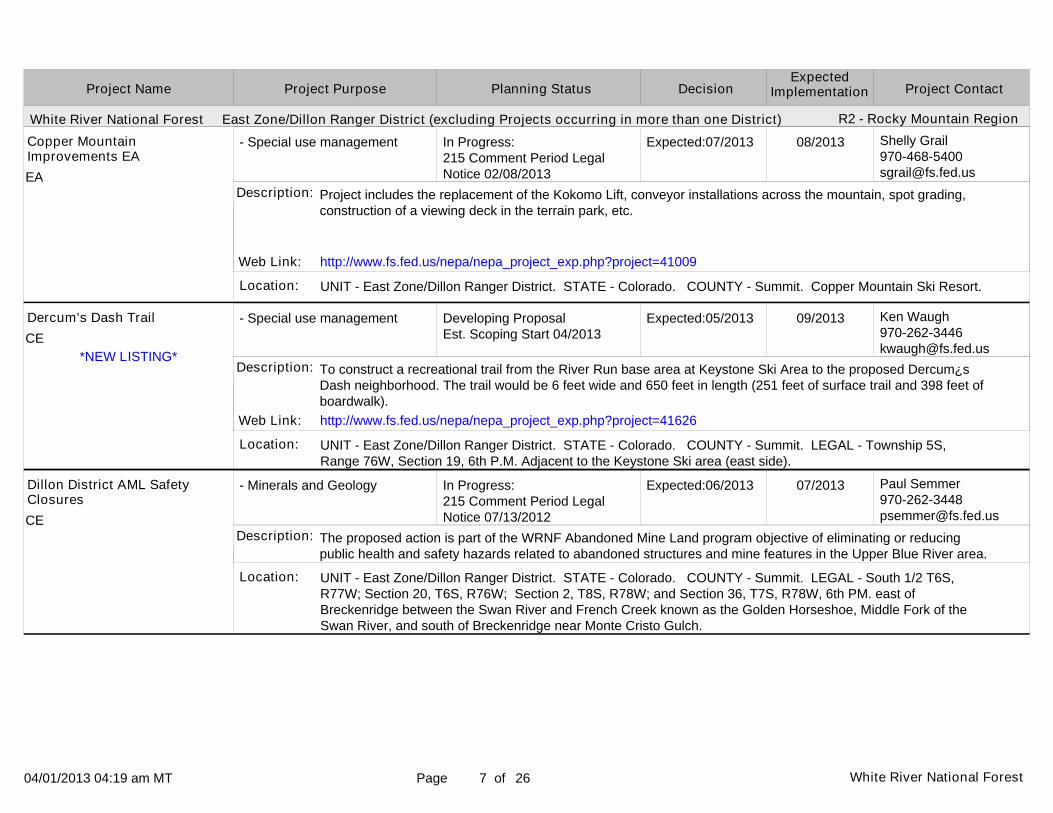
UNIT - East Zone/Dillon Ranger District. STATE - Colorado. COUNTY - Summit. Copper Mountain Ski Resort.
UNIT - East Zone/Dillon Ranger District. STATE - Colorado. COUNTY - Summit. LEGAL - Township 5S, Range 76W, Section 19, 6th P.M. Adjacent to the Keystone Ski area (east side).
UNIT - East Zone/Dillon Ranger District. STATE - Colorado. COUNTY - Summit. LEGAL - South 1/2 T6S, R77W; Section 20, T6S, R76W; Section 2, T8S, R78W; and Section 36, T7S, R78W, 6th PM. east of Breckenridge between the Swan River and French Creek known as the Golden Horseshoe, Middle Fork of the Swan River, and south of Breckenridge near Monte Cristo Gulch.
Location:
Location:
Location:
08/2013
09/2013
07/2013
Copper Mountain Improvements EA
Dercum's Dash Trail
Dillon District AML Safety Closures
Project includes the replacement of the Kokomo Lift, conveyor installations across the mountain, spot grading, construction of a viewing deck in the terrain park, etc.
To construct a recreational trail from the River Run base area at Keystone Ski Area to the proposed Dercum¿s Dash neighborhood. The trail would be 6 feet wide and 650 feet in length (251 feet of surface trail and 398 feet of boardwalk).
The proposed action is part of the WRNF Abandoned Mine Land program objective of eliminating or reducing public health and safety hazards related to abandoned structures and mine features in the Upper Blue River area.
Description:
Description:
Description:
Web Link:
Web Link:
http://www.fs.fed.us/nepa/nepa_project_exp.php?project=41009
http://www.fs.fed.us/nepa/nepa_project_exp.php?project=41626
*NEW LISTING*
EA
CE
CE
04/01/2013 04:19 am MT Page of8 White River National Forest 26
White River National Forest East Zone/Dillon Ranger District (excluding Projects occurring in more than one District)
Project PurposeProject Name DecisionPlanning Status Project ContactExpected
Implementation
R2 - Rocky Mountain Region
- Recreation management - Special use management
- Land ownership management - Special use management
- Special use management
Developing ProposalEst. Scoping Start 05/2013
In Progress:Scoping Start 02/25/2009
Developing ProposalEst. Scoping Start 08/2013
Expected:09/2013
Expected:06/2013
Expected:12/2013
Paul [email protected]
Paul [email protected]
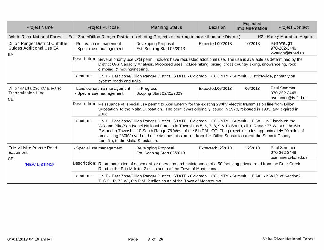
UNIT - East Zone/Dillon Ranger District. STATE - Colorado. COUNTY - Summit. District-wide, primarily on system roads and trails.
UNIT - East Zone/Dillon Ranger District. STATE - Colorado. COUNTY - Summit. LEGAL - NF lands on the WR and Pike/San Isabel National Forests in Townships 5, 6, 7, 8, 9 & 10 South, all in Range 77 West of the 6th PM and in Township 10 South Range 78 West of the 6th PM., CO. The project includes approximately 20 miles of an existing 230kV overhead electric transmission line from the Dillon Substation (near the Summit County Landfill), to the Malta Substation.
UNIT - East Zone/Dillon Ranger District. STATE - Colorado. COUNTY - Summit. LEGAL - NW1/4 of Section2, T. 6 S., R. 76 W., 6th P.M. 2 miles south of the Town of Montezuma.
Location:
Location:
Location:
10/2013
06/2013
12/2013
Dillon Ranger District Outfitter Guides Additional Use EA
Dillon-Malta 230 kV Electric Transmission Line
Erie Millsite Private Road Easement
Several priority use O/G permit holders have requested additional use. The use is available as determined by the District O/G Capacity Analysis. Proposed uses include hiking, biking, cross-country skiing, snowshoeing, rock climbing, & mountaineering.
Reissuance of special use permit to Xcel Energy for the existing 230kV electric transmission line from Dillon Substation, to the Malta Substation. The permit was originally issued in 1978, reissued in 1983, and expired in 2008.
Re-authorization of easement for operation and maintenance of a 50 foot long private road from the Deer Creek Road to the Erie Millsite, 2 miles south of the Town of Montezuma.
Description:
Description:
Description:*NEW LISTING*
EA
CE
CE

04/01/2013 04:19 am MT Page of9 White River National Forest 26
White River National Forest East Zone/Dillon Ranger District (excluding Projects occurring in more than one District)
Project PurposeProject Name DecisionPlanning Status Project ContactExpected
Implementation
R2 - Rocky Mountain Region
- Special use management
- Special use management
- Facility management
- Wildlife, Fish, Rare plants
Developing ProposalEst. Scoping Start 04/2013
In Progress:215 Comment Period Legal Notice 02/10/2012
Cancelled
Developing ProposalEst. Scoping Start 10/2013
Expected:10/2013
Expected:07/2013
N/A
Expected:04/2014
Paul [email protected]
Shelly [email protected]
Kevin [email protected]
Jessica [email protected]
UNIT - East Zone/Dillon Ranger District. STATE - Colorado. COUNTY - Summit. LEGAL - N1/2 of Section 17, T. 5 S., R. 76 W., 6th P.M. US Highway 6 at mile marker 218 about 2 miles east of Keystone on the south side of the highway. Site is adjacent to highway right-of-way and proposed access would use highway right-of-way.
UNIT - East Zone/Dillon Ranger District. STATE - Colorado. COUNTY - Summit. Keystone Ski Resort.
UNIT - East Zone/Dillon Ranger District. STATE - Colorado. COUNTY - Summit. LEGAL - T. 5 S., R. 78 W., Section 24, 6th P.M. Northwest of Dillon Dam Road across from Heaton Bay Campground, in Summit County, Colorado.
UNIT - East Zone/Dillon Ranger District. STATE - Colorado. COUNTY - Summit. All vacant grazing allotments on the east side of the Lower Blue River and north of Ute Pass.
Location:
Location:
Location:
Location:
06/2014
08/2013
N/A
07/2014
Fidelity Tower- East Keystone Communications Site
Keystone Frontside Improvements
Lake Hill Work Compound Development Project
Lower Blue Sagebrush Enhancement Project
New authorization for construction of a cellular phone communication site along US Hwy 6 between A-Basin and Keystone (East Keystone). The facility will be a multi-carrier facility consisting of one prefabricated equipment shelter and 2 towers.
Keystone proposes a variety of frontside improvements including relocation and replacement of the Summit HouseRestaurant, new mountain bike trails, ski school trail construction, etc.
This project will include design and construction of a work compound including, warehouse, storage buildings, and employee quarters facilities on Forest Service land northwest of Heaton Bay Campground.
Construct water dev. to enhance sagegrouse brood-rearing habitat. Design & implement a livestock grazing prog. to enhance habitat conditions required for all sagegrouse life stages in partnership with current & future livestock grazing permittees.
Description:
Description:
Description:
Description:
Web Link: http://www.fs.fed.us/nepa/nepa_project_exp.php?project=33608
*NEW LISTING*
*NEW LISTING*
EA
EA
EA
EA
04/01/2013 04:19 am MT Page of10 White River National Forest 26
White River National Forest East Zone/Dillon Ranger District (excluding Projects occurring in more than one District)
Project PurposeProject Name DecisionPlanning Status Project ContactExpected
Implementation
R2 - Rocky Mountain Region
- Special use management
- Special use management
- Special use management
- Recreation management - Special use management
In Progress:215 Comment Period Legal Notice 02/15/2013
In Progress:215 Comment Period Legal Notice 03/01/2013
In Progress:215 Comment Period Legal Notice 12/12/2012
In Progress:Scoping Start 10/24/2011Est. 215 Comment Period LegalNotice 05/2013
Expected:08/2013
Expected:04/2013
Expected:06/2013
Expected:10/2013
Paul [email protected]
Shelly [email protected]
Paul [email protected]
Shelly [email protected]
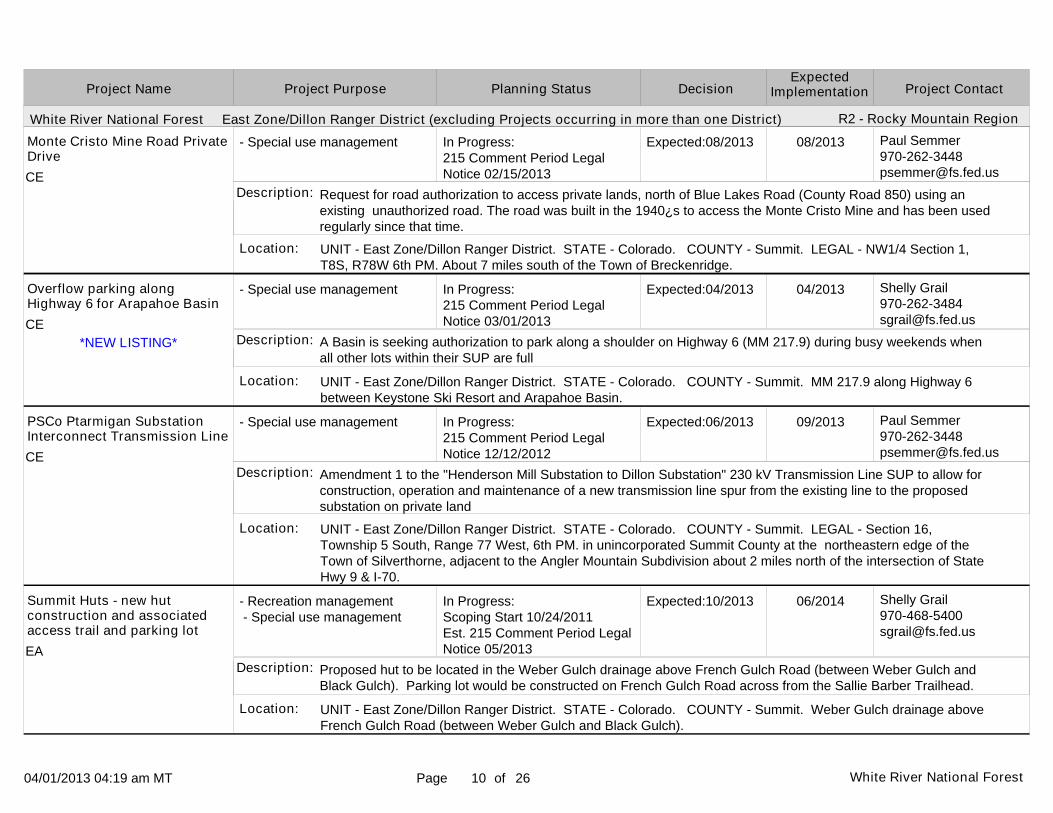
UNIT - East Zone/Dillon Ranger District. STATE - Colorado. COUNTY - Summit. LEGAL - NW1/4 Section 1, T8S, R78W 6th PM. About 7 miles south of the Town of Breckenridge.
UNIT - East Zone/Dillon Ranger District. STATE - Colorado. COUNTY - Summit. MM 217.9 along Highway 6 between Keystone Ski Resort and Arapahoe Basin.
UNIT - East Zone/Dillon Ranger District. STATE - Colorado. COUNTY - Summit. LEGAL - Section 16, Township 5 South, Range 77 West, 6th PM. in unincorporated Summit County at the northeastern edge of the Town of Silverthorne, adjacent to the Angler Mountain Subdivision about 2 miles north of the intersection of State Hwy 9 & I-70.
UNIT - East Zone/Dillon Ranger District. STATE - Colorado. COUNTY - Summit. Weber Gulch drainage aboveFrench Gulch Road (between Weber Gulch and Black Gulch).
Location:
Location:
Location:
Location:
08/2013
04/2013
09/2013
06/2014
Monte Cristo Mine Road PrivateDrive
Overflow parking along Highway 6 for Arapahoe Basin
PSCo Ptarmigan Substation Interconnect Transmission Line
Summit Huts - new hut construction and associated access trail and parking lot
Request for road authorization to access private lands, north of Blue Lakes Road (County Road 850) using an existing unauthorized road. The road was built in the 1940¿s to access the Monte Cristo Mine and has been used regularly since that time.
A Basin is seeking authorization to park along a shoulder on Highway 6 (MM 217.9) during busy weekends when all other lots within their SUP are full
Amendment 1 to the "Henderson Mill Substation to Dillon Substation" 230 kV Transmission Line SUP to allow for construction, operation and maintenance of a new transmission line spur from the existing line to the proposed substation on private land
Proposed hut to be located in the Weber Gulch drainage above French Gulch Road (between Weber Gulch and Black Gulch). Parking lot would be constructed on French Gulch Road across from the Sallie Barber Trailhead.
Description:
Description:
Description:
Description:
*NEW LISTING*
CE
CE
CE
EA
04/01/2013 04:19 am MT Page of11 White River National Forest 26
White River National Forest East Zone/Dillon Ranger District (excluding Projects occurring in more than one District)
White River National Forest East Zone/Eagle Ranger District (excluding Projects occurring in more than one District)
Project PurposeProject Name DecisionPlanning Status Project ContactExpected
Implementation
R2 - Rocky Mountain Region
R2 - Rocky Mountain Region
- Wildlife, Fish, Rare plants - Watershed management
- Recreation management
- Land ownership management - Special use management
Developing ProposalEst. Scoping Start 04/2013
In Progress:215 Comment Period Legal Notice 11/15/2012
In Progress:215 Comment Period Legal Notice 05/11/2012
Expected:02/2014
Expected:08/2013
Expected:04/2013
Corey [email protected]
Paul [email protected]
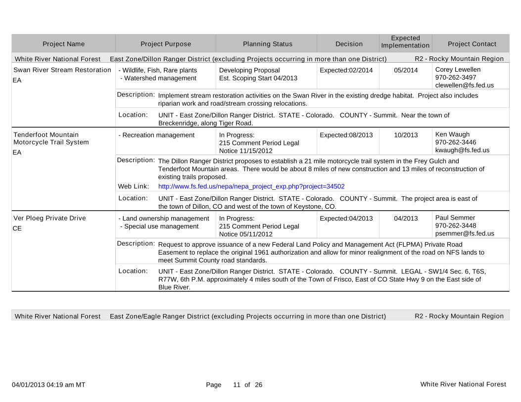
UNIT - East Zone/Dillon Ranger District. STATE - Colorado. COUNTY - Summit. Near the town of Breckenridge, along Tiger Road.
UNIT - East Zone/Dillon Ranger District. STATE - Colorado. COUNTY - Summit. The project area is east of the town of Dillon, CO and west of the town of Keystone, CO.
UNIT - East Zone/Dillon Ranger District. STATE - Colorado. COUNTY - Summit. LEGAL - SW1/4 Sec. 6, T6S,R77W, 6th P.M. approximately 4 miles south of the Town of Frisco, East of CO State Hwy 9 on the East side of Blue River.
Location:
Location:
Location:
05/2014
10/2013
04/2013
Swan River Stream Restoration
Tenderfoot Mountain Motorcycle Trail System
Ver Ploeg Private Drive
Implement stream restoration activities on the Swan River in the existing dredge habitat. Project also includes riparian work and road/stream crossing relocations.
The Dillon Ranger District proposes to establish a 21 mile motorcycle trail system in the Frey Gulch and Tenderfoot Mountain areas. There would be about 8 miles of new construction and 13 miles of reconstruction of existing trails proposed.
Request to approve issuance of a new Federal Land Policy and Management Act (FLPMA) Private Road Easement to replace the original 1961 authorization and allow for minor realignment of the road on NFS lands to meet Summit County road standards.
Description:
Description:
Description:
Web Link: http://www.fs.fed.us/nepa/nepa_project_exp.php?project=34502
EA
EA
CE
04/01/2013 04:19 am MT Page of12 White River National Forest 26
White River National Forest East Zone/Eagle Ranger District (excluding Projects occurring in more than one District)
Project PurposeProject Name DecisionPlanning Status Project ContactExpected
Implementation
R2 - Rocky Mountain Region
- Land ownership management
- Forest products - Vegetation management (other than forest products) - Fuels management
- Grazing management
- Special use management
On Hold
Developing ProposalEst. Scoping Start 10/2013
In Progress:215 Comment Period Legal Notice 02/16/2011
On Hold
N/A
Expected:05/2014
Expected:05/2013
N/A
Kevin [email protected]
Brett [email protected]
Jessica [email protected]
Bill [email protected]
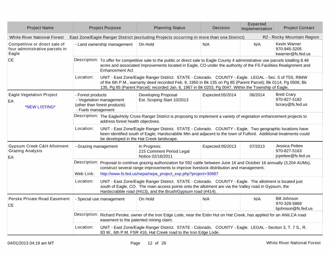
UNIT - East Zone/Eagle Ranger District. STATE - Colorado. COUNTY - Eagle. LEGAL - Sec. 5 of T5S, R84Wof the 6th P.M., warranty deed recorded Feb. 9, 1950 in Bk 135 on Pg 85 (Parent Parcel); Bk 0114, Pg 0506; Bk 135, Pg 85 (Parent Parcel); recorded Jan. 6, 1967 in Bk 0203, Pg 0047. Within the Township of Eagle.
UNIT - East Zone/Eagle Ranger District. STATE - Colorado. COUNTY - Eagle. Two geographic locations havebeen identified south of Eagle; Hardscrabble Mtn and adjacent to the town of Fulford. Additional treatments could be developed in the Hat Creek landscape.
UNIT - East Zone/Eagle Ranger District. STATE - Colorado. COUNTY - Eagle. The allotment is located just south of Eagle, CO. The main access points onto the allotment are via the Valley road in Gypsum, the Hardscrabble road (#413), and the Brush/Gypsum road (#414).
UNIT - East Zone/Eagle Ranger District. STATE - Colorado. COUNTY - Eagle. LEGAL - Section 3, T. 7 S., R. 83 W., 6th P.M. FSR 416, Hat Creek road to the Iron Edge Lode.
Location:
Location:
Location:
Location:
N/A
06/2014
07/2013
N/A
Competitive or direct sale of four administrative parcels in Eagle
Eagle Vegetation Project
Gypsum Creek C&H Allotment Grazing Analysis
Perske Private Road Easement
To offer for competitive sale to the public or direct sale to Eagle County 4 administrative use parcels totalling 8.48 acres and associated improvements located in Eagle, CO under the authority of the FS Facilities Realignment and Enhancement Act
The Eagle/Holy Cross Ranger District is proposing to implement a variety of vegetation enhancement projects to address forest health objectives.
Proposal to continue grazing authorization for 592 cattle between June 16 and October 16 annually (3,204 AUMs), construct several range improvements to improve livestock distribution and management.
Richard Perske, owner of the Iron Edge Lode, near the Estin Hut on Hat Creek, has applied for an ANILCA road easement to the patented mining claim.
Description:
Description:
Description:
Description:
Web Link: http://www.fs.fed.us/nepa/nepa_project_exp.php?project=30687
*NEW LISTING*
CE
EA
EA
CE
04/01/2013 04:19 am MT Page of13 White River National Forest 26
White River National Forest East Zone/Eagle Ranger District (excluding Projects occurring in more than one District)
White River National Forest East Zone/Holy Cross Ranger District (excluding Projects occurring in more than one District)
Project PurposeProject Name DecisionPlanning Status Project ContactExpected
Implementation
R2 - Rocky Mountain Region
R2 - Rocky Mountain Region
- Special use management
- Land acquisition
- Special use management
In Progress:Scoping Start 11/20/2012Est. 215 Comment Period LegalNotice 04/2013
On Hold
In Progress:Scoping Start 01/31/2011Est. 215 Comment Period LegalNotice 04/2013
Expected:09/2013
N/A
Expected:05/2013
Bill [email protected]
Bill [email protected]
Bill [email protected]
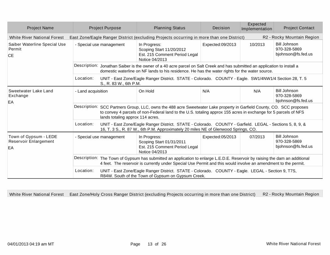
UNIT - East Zone/Eagle Ranger District. STATE - Colorado. COUNTY - Eagle. SW1/4NW1/4 Section 28, T. 5 S., R. 83 W., 6th P.M.
UNIT - East Zone/Eagle Ranger District. STATE - Colorado. COUNTY - Garfield. LEGAL - Sections 5, 8, 9, & 16, T. 3 S., R. 87 W., 6th P.M. Approximately 20 miles NE of Glenwood Springs, CO.
UNIT - East Zone/Eagle Ranger District. STATE - Colorado. COUNTY - Eagle. LEGAL - Section 9, T7S, R84W. South of the Town of Gypsum on Gypsum Creek.
Location:
Location:
Location:
10/2013
N/A
07/2013
Saiber Waterline Special Use Permit
Sweetwater Lake Land Exchange
Town of Gypsum - LEDE Reservoir Enlargement
Jonathan Saiber is the owner of a 40 acre parcel on Salt Creek and has submitted an application to install a domestic waterline on NF lands to his residence. He has the water rights for the water source.
SCC Partners Group, LLC, owns the 488 acre Sweetwater Lake property in Garfield County, CO. SCC proposes to convey 4 parcels of non-Federal land to the U.S. totaling approx 155 acres in exchange for 5 parcels of NFS lands totaling approx 114 acres.
The Town of Gypsum has submitted an application to enlarge L.E.D.E. Reservoir by raising the dam an additional 4 feet. The reservoir is currently under Special Use Permit and this would involve an amendment to the permit.
Description:
Description:
Description:
CE
EA
EA
04/01/2013 04:19 am MT Page of14 White River National Forest 26
White River National Forest East Zone/Holy Cross Ranger District (excluding Projects occurring in more than one District)
Project PurposeProject Name DecisionPlanning Status Project ContactExpected
Implementation
R2 - Rocky Mountain Region
- Special use management
- Regulations, Directives, Orders
- Wildlife, Fish, Rare plants
- Forest products
Developing ProposalEst. Scoping Start 04/2013
In Progress:215 Comment Period Legal Notice 05/03/2012
In Progress:215 Comment Period Legal Notice 03/28/2013
In Progress:Scoping Start 08/16/2012Est. 215 Comment Period LegalNotice 04/2013
Expected:10/2013
Expected:05/2013Actual: 06/21/2012
Expected:06/2013
Expected:06/2013
Bill [email protected]
Olivia [email protected]
Matthew [email protected]
Shelby [email protected]
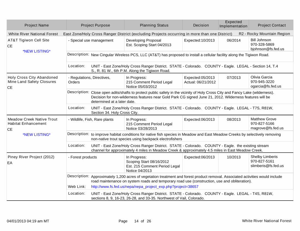
UNIT - East Zone/Holy Cross Ranger District. STATE - Colorado. COUNTY - Eagle. LEGAL - Section 14, T.4 S., R. 81 W., 6th P.M. Along the Tigiwon Road.
UNIT - East Zone/Holy Cross Ranger District. STATE - Colorado. COUNTY - Eagle. LEGAL - T7S, R81W, Section 34. Holy Cross City.
UNIT - East Zone/Holy Cross Ranger District. STATE - Colorado. COUNTY - Eagle. the existing stream channel for approximately 4 miles in Meadow Creek & approximately 4.5 miles in East Meadow Creek.
UNIT - East Zone/Holy Cross Ranger District. STATE - Colorado. COUNTY - Eagle. LEGAL - T4S, R81W, sections 8, 9, 16-23, 26-28, and 33-35. Northwest of Vail, Colorado.
Location:
Location:
Location:
Location:
06/2014
07/2013
08/2013
10/2013
AT&T Tigiwon Cell Site
Holy Cross City Abandoned Mine Land Safety Closures
Meadow Creek Native Trout Habitat Enhancement
Piney River Project (2012)
New Cingular Wireless PCS, LLC (AT&T) has proposed to install a cellular facility along the Tigiwon Road.
Close open adits/shafts to protect public safety in the vicinity of Holy Cross City and Fancy Lake (wilderness). Decision for non-wilderness features near Gold Park CG signed June 21, 2012. Wilderness features will be determined at a later date.
to improve habitat conditions for native fish species in Meadow and East Meadow Creeks by selectively removing non-native trout species using backpack electrofishers
Approximately 1,200 acres of vegetation treatment and forest product removal. Associated activities would include road maintenance on system roads and temporary road use (construction, use and obliteration).
Description:
Description:
Description:
Description:
Web Link: http://www.fs.fed.us/nepa/nepa_project_exp.php?project=38657
*NEW LISTING*
*NEW LISTING*
CE
CE
CE
EA
04/01/2013 04:19 am MT Page of15 White River National Forest 26
White River National Forest East Zone/Holy Cross Ranger District (excluding Projects occurring in more than one District)
White River National Forest West Zone/Aspen Ranger District (excluding Projects occurring in more than one District)
Project PurposeProject Name DecisionPlanning Status Project ContactExpected
Implementation
R2 - Rocky Mountain Region
R2 - Rocky Mountain Region
- Wildlife, Fish, Rare plants
- Recreation management
- Special use management
On Hold
In Progress:NOI in Federal Register 11/26/2012Est. DEIS NOA in Federal Register 09/2013
In Progress:215 Comment Period Legal Notice 02/28/2013
N/A
Expected:03/2014
Expected:04/2013
Matthew [email protected]
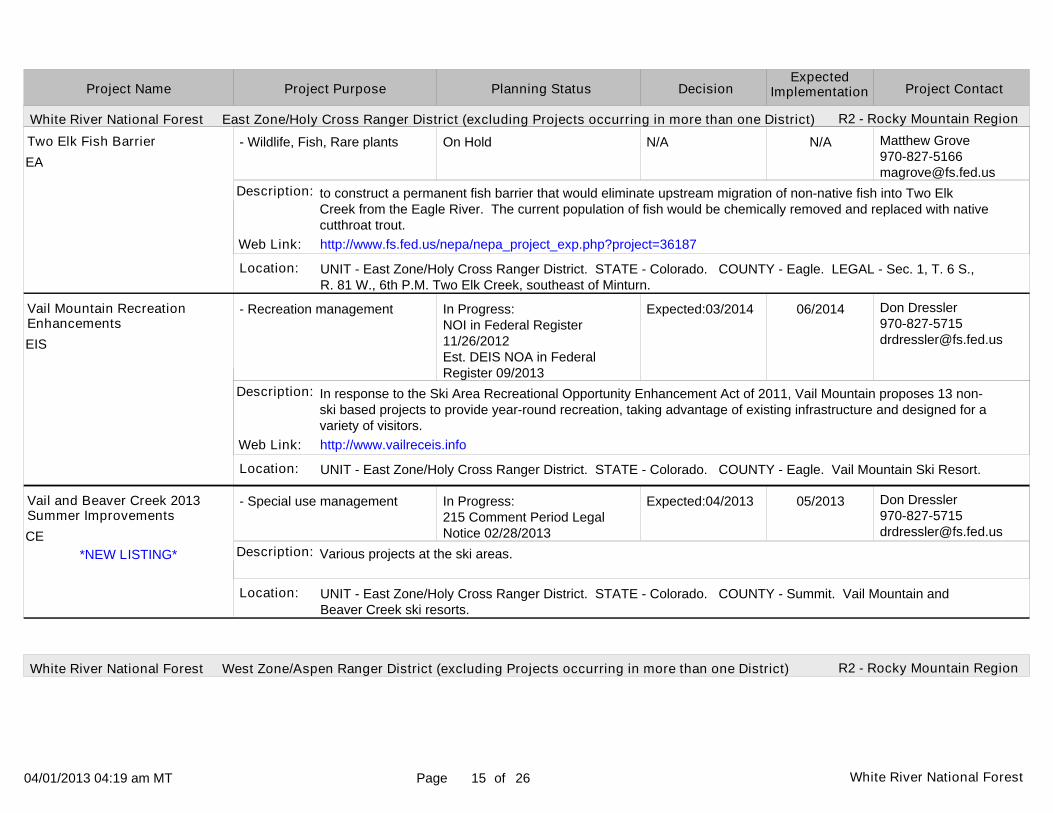
UNIT - East Zone/Holy Cross Ranger District. STATE - Colorado. COUNTY - Eagle. LEGAL - Sec. 1, T. 6 S., R. 81 W., 6th P.M. Two Elk Creek, southeast of Minturn.
UNIT - East Zone/Holy Cross Ranger District. STATE - Colorado. COUNTY - Eagle. Vail Mountain Ski Resort.
UNIT - East Zone/Holy Cross Ranger District. STATE - Colorado. COUNTY - Summit. Vail Mountain and Beaver Creek ski resorts.
Location:
Location:
Location:
N/A
06/2014
05/2013
Two Elk Fish Barrier
Vail Mountain Recreation Enhancements
Vail and Beaver Creek 2013 Summer Improvements
to construct a permanent fish barrier that would eliminate upstream migration of non-native fish into Two Elk Creek from the Eagle River. The current population of fish would be chemically removed and replaced with native cutthroat trout.
In response to the Ski Area Recreational Opportunity Enhancement Act of 2011, Vail Mountain proposes 13 non-ski based projects to provide year-round recreation, taking advantage of existing infrastructure and designed for a variety of visitors.
Various projects at the ski areas.
Description:
Description:
Description:
Web Link:
Web Link:
http://www.fs.fed.us/nepa/nepa_project_exp.php?project=36187
http://www.vailreceis.info
*NEW LISTING*
EA
EIS
CE
04/01/2013 04:19 am MT Page of16 White River National Forest 26
White River National Forest West Zone/Aspen Ranger District (excluding Projects occurring in more than one District)
Project PurposeProject Name DecisionPlanning Status Project ContactExpected
Implementation
R2 - Rocky Mountain Region
- Facility management
- Special use management
- Land ownership management
On Hold
Developing ProposalEst. Scoping Start 04/2013
In Progress:215 Comment Period Legal Notice 07/13/2012
N/A
Expected:06/2013
Expected:04/2013
Kevin [email protected]
Matthew [email protected]
Kevin [email protected]
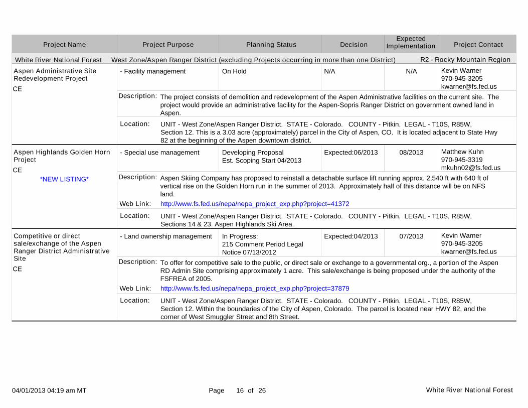
UNIT - West Zone/Aspen Ranger District. STATE - Colorado. COUNTY - Pitkin. LEGAL - T10S, R85W, Section 12. This is a 3.03 acre (approximately) parcel in the City of Aspen, CO. It is located adjacent to State Hwy82 at the beginning of the Aspen downtown district.
UNIT - West Zone/Aspen Ranger District. STATE - Colorado. COUNTY - Pitkin. LEGAL - T10S, R85W, Sections 14 & 23. Aspen Highlands Ski Area.
UNIT - West Zone/Aspen Ranger District. STATE - Colorado. COUNTY - Pitkin. LEGAL - T10S, R85W, Section 12. Within the boundaries of the City of Aspen, Colorado. The parcel is located near HWY 82, and the corner of West Smuggler Street and 8th Street.
Location:
Location:
Location:
N/A
08/2013
07/2013
Aspen Administrative Site Redevelopment Project
Aspen Highlands Golden Horn Project
Competitive or direct sale/exchange of the Aspen Ranger District Administrative Site
The project consists of demolition and redevelopment of the Aspen Administrative facilities on the current site. Theproject would provide an administrative facility for the Aspen-Sopris Ranger District on government owned land in Aspen.
Aspen Skiing Company has proposed to reinstall a detachable surface lift running approx. 2,540 ft with 640 ft of vertical rise on the Golden Horn run in the summer of 2013. Approximately half of this distance will be on NFS land.
To offer for competitive sale to the public, or direct sale or exchange to a governmental org., a portion of the AspenRD Admin Site comprising approximately 1 acre. This sale/exchange is being proposed under the authority of the FSFREA of 2005.
Description:
Description:
Description:
Web Link:
Web Link:
http://www.fs.fed.us/nepa/nepa_project_exp.php?project=41372
http://www.fs.fed.us/nepa/nepa_project_exp.php?project=37879
*NEW LISTING*
CE
CE
CE
04/01/2013 04:19 am MT Page of17 White River National Forest 26
White River National Forest West Zone/Aspen Ranger District (excluding Projects occurring in more than one District)
Project PurposeProject Name DecisionPlanning Status Project ContactExpected
Implementation
R2 - Rocky Mountain Region
- Special use management
- Watershed management
- Recreation management - Wildlife, Fish, Rare plants - Vegetation management (other than forest products)
- Road management
In Progress:215 Comment Period Legal Notice 06/30/2010
In Progress:215 Comment Period Legal Notice 06/30/2010
In Progress:215 Comment Period Legal Notice 03/28/2013
In Progress:215 Comment Period Legal Notice 05/04/2012
Expected:09/2013
Expected:05/2013
Expected:07/2013
Expected:09/2013
James [email protected]
James [email protected]
Martha [email protected]
James [email protected]
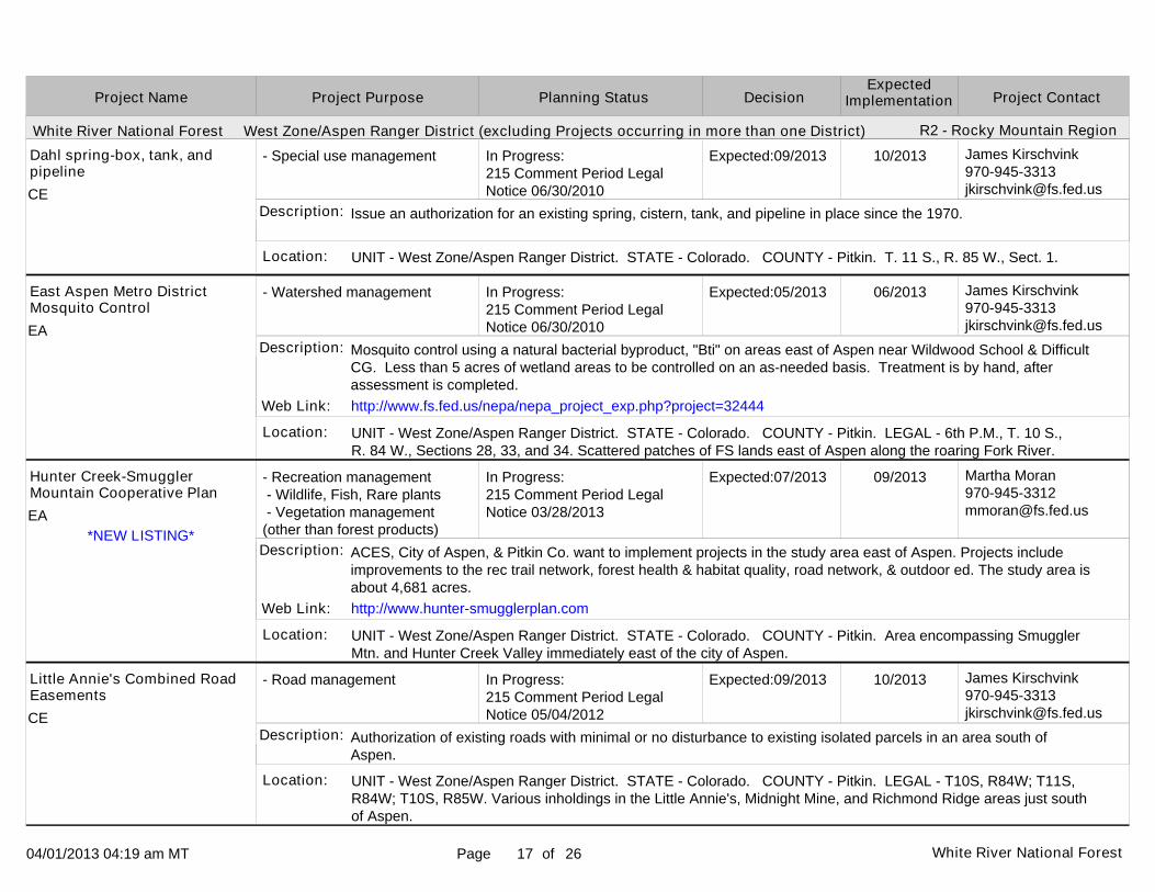
UNIT - West Zone/Aspen Ranger District. STATE - Colorado. COUNTY - Pitkin. T. 11 S., R. 85 W., Sect. 1.
UNIT - West Zone/Aspen Ranger District. STATE - Colorado. COUNTY - Pitkin. LEGAL - 6th P.M., T. 10 S., R. 84 W., Sections 28, 33, and 34. Scattered patches of FS lands east of Aspen along the roaring Fork River.
UNIT - West Zone/Aspen Ranger District. STATE - Colorado. COUNTY - Pitkin. Area encompassing SmugglerMtn. and Hunter Creek Valley immediately east of the city of Aspen.
UNIT - West Zone/Aspen Ranger District. STATE - Colorado. COUNTY - Pitkin. LEGAL - T10S, R84W; T11S,R84W; T10S, R85W. Various inholdings in the Little Annie's, Midnight Mine, and Richmond Ridge areas just southof Aspen.
Location:
Location:
Location:
Location:
10/2013
06/2013
09/2013
10/2013
Dahl spring-box, tank, and pipeline
East Aspen Metro District Mosquito Control
Hunter Creek-Smuggler Mountain Cooperative Plan
Little Annie's Combined Road Easements
Issue an authorization for an existing spring, cistern, tank, and pipeline in place since the 1970.
Mosquito control using a natural bacterial byproduct, "Bti" on areas east of Aspen near Wildwood School & DifficultCG. Less than 5 acres of wetland areas to be controlled on an as-needed basis. Treatment is by hand, after assessment is completed.
ACES, City of Aspen, & Pitkin Co. want to implement projects in the study area east of Aspen. Projects include improvements to the rec trail network, forest health & habitat quality, road network, & outdoor ed. The study area isabout 4,681 acres.
Authorization of existing roads with minimal or no disturbance to existing isolated parcels in an area south of Aspen.
Description:
Description:
Description:
Description:
Web Link:
Web Link:
http://www.fs.fed.us/nepa/nepa_project_exp.php?project=32444
http://www.hunter-smugglerplan.com
*NEW LISTING*
CE
EA
EA
CE
04/01/2013 04:19 am MT Page of18 White River National Forest 26
White River National Forest West Zone/Aspen Ranger District (excluding Projects occurring in more than one District)
Project PurposeProject Name DecisionPlanning Status Project ContactExpected
Implementation
R2 - Rocky Mountain Region
- Special use management
- Special use management
- Special use management
- Land management planning
In Progress:215 Comment Period Legal Notice 06/30/2010
In Progress:215 Comment Period Legal Notice 02/22/2013
In Progress:Scoping Start 02/02/2009Est. 215 Comment Period LegalNotice 08/2013
In Progress:215 Comment Period Legal Notice 06/07/2012
Expected:07/2013
Expected:06/2013
Expected:09/2013
Expected:11/2013
James [email protected]
James [email protected]
Jonathan [email protected]
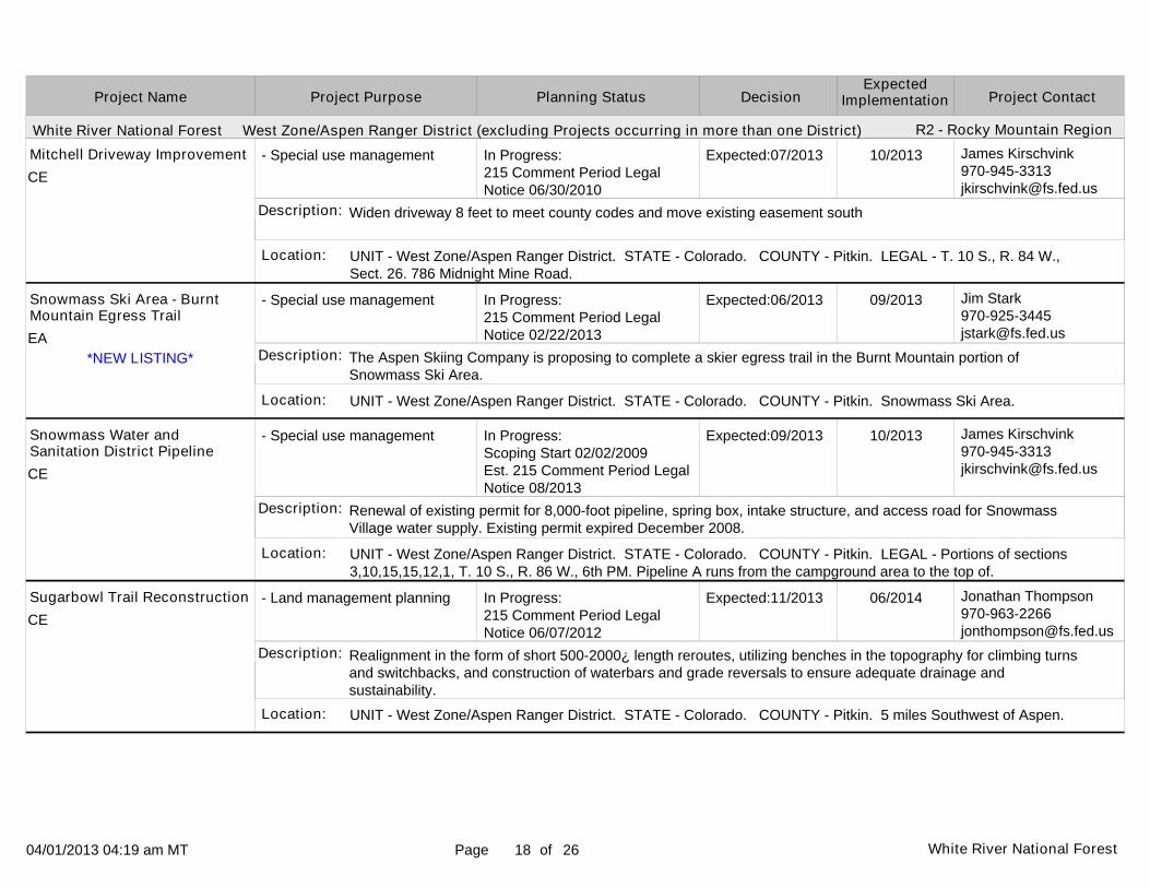
UNIT - West Zone/Aspen Ranger District. STATE - Colorado. COUNTY - Pitkin. LEGAL - T. 10 S., R. 84 W., Sect. 26. 786 Midnight Mine Road.
UNIT - West Zone/Aspen Ranger District. STATE - Colorado. COUNTY - Pitkin. Snowmass Ski Area.
UNIT - West Zone/Aspen Ranger District. STATE - Colorado. COUNTY - Pitkin. LEGAL - Portions of sections 3,10,15,15,12,1, T. 10 S., R. 86 W., 6th PM. Pipeline A runs from the campground area to the top of.
UNIT - West Zone/Aspen Ranger District. STATE - Colorado. COUNTY - Pitkin. 5 miles Southwest of Aspen.
Location:
Location:
Location:
Location:
10/2013
09/2013
10/2013
06/2014
Mitchell Driveway Improvement
Snowmass Ski Area - Burnt Mountain Egress Trail
Snowmass Water and Sanitation District Pipeline
Sugarbowl Trail Reconstruction
Widen driveway 8 feet to meet county codes and move existing easement south
The Aspen Skiing Company is proposing to complete a skier egress trail in the Burnt Mountain portion of Snowmass Ski Area.
Renewal of existing permit for 8,000-foot pipeline, spring box, intake structure, and access road for Snowmass Village water supply. Existing permit expired December 2008.
Realignment in the form of short 500-2000¿ length reroutes, utilizing benches in the topography for climbing turns and switchbacks, and construction of waterbars and grade reversals to ensure adequate drainage and sustainability.
Description:
Description:
Description:
Description:
*NEW LISTING*
CE
EA
CE
CE
04/01/2013 04:19 am MT Page of19 White River National Forest 26
White River National Forest West Zone/Aspen Ranger District (excluding Projects occurring in more than one District)
White River National Forest West Zone/Blanco Ranger District (excluding Projects occurring in more than one District)
Project PurposeProject Name DecisionPlanning Status Project ContactExpected
Implementation
R2 - Rocky Mountain Region
R2 - Rocky Mountain Region
- Recreation management
- Special use management - Road management
- Special use management
In Progress:215 Comment Period Legal Notice 05/04/2012
In Progress:Scoping Start 03/02/2009Est. 215 Comment Period LegalNotice 08/2013
Developing ProposalEst. Scoping Start 07/2013
Expected:07/2013
Expected:09/2013
Expected:08/2013
James [email protected]
James [email protected]
James [email protected]
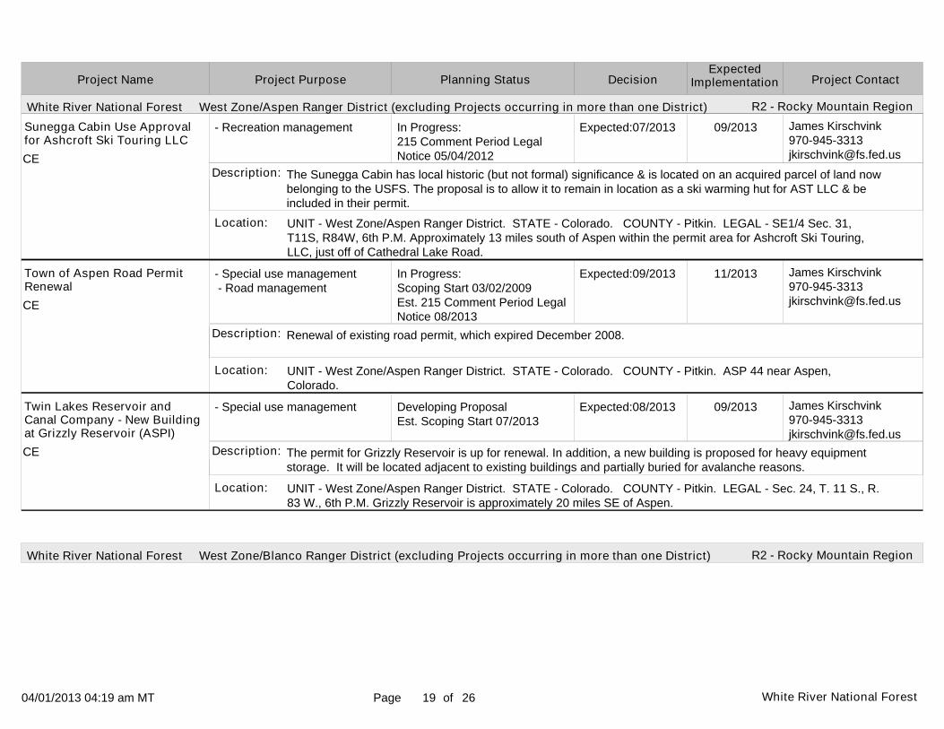
UNIT - West Zone/Aspen Ranger District. STATE - Colorado. COUNTY - Pitkin. LEGAL - SE1/4 Sec. 31, T11S, R84W, 6th P.M. Approximately 13 miles south of Aspen within the permit area for Ashcroft Ski Touring, LLC, just off of Cathedral Lake Road.
UNIT - West Zone/Aspen Ranger District. STATE - Colorado. COUNTY - Pitkin. ASP 44 near Aspen, Colorado.
UNIT - West Zone/Aspen Ranger District. STATE - Colorado. COUNTY - Pitkin. LEGAL - Sec. 24, T. 11 S., R.83 W., 6th P.M. Grizzly Reservoir is approximately 20 miles SE of Aspen.
Location:
Location:
Location:
09/2013
11/2013
09/2013
Sunegga Cabin Use Approval for Ashcroft Ski Touring LLC
Town of Aspen Road Permit Renewal
Twin Lakes Reservoir and Canal Company - New Buildingat Grizzly Reservoir (ASPI)
The Sunegga Cabin has local historic (but not formal) significance & is located on an acquired parcel of land now belonging to the USFS. The proposal is to allow it to remain in location as a ski warming hut for AST LLC & be included in their permit.
Renewal of existing road permit, which expired December 2008.
The permit for Grizzly Reservoir is up for renewal. In addition, a new building is proposed for heavy equipment storage. It will be located adjacent to existing buildings and partially buried for avalanche reasons.
Description:
Description:
Description:
CE
CE
CE

04/01/2013 04:19 am MT Page of20 White River National Forest 26
White River National Forest West Zone/Blanco Ranger District (excluding Projects occurring in more than one District)
White River National Forest West Zone/Rifle Ranger District (excluding Projects occurring in more than one District)
Project PurposeProject Name DecisionPlanning Status Project ContactExpected
Implementation
R2 - Rocky Mountain Region
R2 - Rocky Mountain Region
- Special use management
- Special use management
- Grazing management
In Progress:215 Comment Period Legal Notice 12/12/2012
In Progress:Scoping Start 11/23/2010Est. 215 Comment Period LegalNotice 08/2013
In Progress:Scoping Start 12/22/2011Est. 215 Comment Period LegalNotice 05/2013
Expected:09/2013
Expected:09/2013
Expected:07/2013
Richard [email protected]
Richard [email protected]
Lydia LaBelle de [email protected]
UNIT - West Zone/Blanco Ranger District. STATE - Colorado. COUNTY - Rio Blanco. LEGAL - T. 1 N., R. 90 W., Sections 28 & 33; T. 1 S., R. 90 W., Section 3, 6th P.M. approximately 23 miles east of Meeker, CO.
UNIT - West Zone/Blanco Ranger District. STATE - Colorado. COUNTY - Rio Blanco. approximately 17 miles northeast of Meeker, CO.
UNIT - West Zone/Rifle Ranger District. STATE - Colorado. COUNTY - Garfield, Mesa. LEGAL - Hunter T.7.S, R.93.W and Wallace T.8.S., R.95.W. Hunter is approximately 6 miles southwest of town of Rifle; access via CR 317. Wallace is approximately 7 miles northwest of town of Collbran; access via the Kimball Creek Rd.
Location:
Location:
Location:
10/2013
10/2013
09/2013
Ditch Bill Easement for Campbell Creek Ditch
Milk Creek Ranch's John Rescorla Ditch Special Use Permit
Hunter Creek and Wallace Grazing Allotments
Authorize operation and maintenance of an existing irrigation ditch under the Colorado Ditch Bill
Authorize a special use permit for the John Rescorla Ditch across National Forest lands for the purpose of irrigating private lands.
The Rifle Ranger District proposes to reauthorize domestic livestock grazing on Hunter & Wallace allotments. Includes construction of range improvements to aid in livestock distribution and management.
Description:
Description:
Description:
Web Link: http://www.fs.fed.us/nepa/nepa_project_exp.php?project=37881
CE
CE
EA
04/01/2013 04:19 am MT Page of21 White River National Forest 26
White River National Forest West Zone/Rifle Ranger District (excluding Projects occurring in more than one District)
Project PurposeProject Name DecisionPlanning Status Project ContactExpected
Implementation
R2 - Rocky Mountain Region
- Minerals and Geology
- Minerals and Geology
- Recreation management - Road management
- Recreation management - Special use management
In Progress:215 Comment Period Legal Notice 09/27/2012
On Hold
Developing ProposalEst. Scoping Start 04/2013
Completed
Expected:06/2013
N/A
Expected:06/2013
Actual: 03/05/2013
Jason [email protected]
Jason [email protected]
Karla [email protected]
Kyle [email protected]
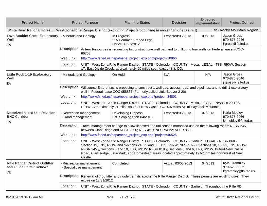
UNIT - West Zone/Rifle Ranger District. STATE - Colorado. COUNTY - Mesa. LEGAL - T8S, R90W, Section 17. East Divide Creek, approximately 20 miles southeast of Silt, CO.
UNIT - West Zone/Rifle Ranger District. STATE - Colorado. COUNTY - Mesa. LEGAL - NW Sec 20 T8S R91W. Approximately 21 miles south of New Castle, CO; 0.5 miles SE of Haystack Mountain.
UNIT - West Zone/Rifle Ranger District. STATE - Colorado. COUNTY - Garfield. LEGAL - NFSR 860 - Section 19, T3S, R91W and Sections 24, 25 and 36, T3S, R92W; NFSR 822 - Sections 10, 15, 22, T3S, R91W; NFSR 245 ¿ Sections 3 and 10, T3S, R91W: NFSR 819 ¿ Sections 5 and 6, T4S, R91W. Buford New Castle Road, Clark Ridge, Lake Park, and Homestead areas located approximately 12 to17 miles northwest of New Castle.
UNIT - West Zone/Rifle Ranger District. STATE - Colorado. COUNTY - Garfield. Throughout the Rifle RD.
Location:
Location:
Location:
Location:
09/2013
N/A
07/2013
04/2013
Lava Boulder Creek ExploratoryWell
Little Rock 1-19 Exploratory Well
Motorized Mixed Use Revision BNC Corridor
Rifle Ranger District Outfitter and Guide Permit Renewal
Antero Resources is requesting to construct one well pad and to drill up to four wells on Federal lease #COC-66708.
Willsource Enterprises is proposing to construct 1 well pad, access road, and pipelines; and to drill 1 exploratory well in Federal lease COC 058835 (Formerly called Little Beaver 2-20)
Travel management change to allow licensed and unlicensed motorized use on the following roads: NFSR 245, between Clark Ridge and NFST 2290; NFSR819; NFSRN822; NFSR 860.
Renewal of 7 outfitter and guide permits across the Rifle Ranger District. These permits are existing uses. They expire on 12/31/2012.
Description:
Description:
Description:
Description:
Web Link:
Web Link:
Web Link:
http://www.fs.fed.us/nepa/nepa_project_exp.php?project=28966
http://www.fs.fed.us/nepa/nepa_project_exp.php?project=34801
http://www.fs.fed.us/nepa/nepa_project_exp.php?project=40525
EA
EA
EA
CE
04/01/2013 04:19 am MT Page of22 White River National Forest 26
White River National Forest West Zone/Rifle Ranger District (excluding Projects occurring in more than one District)
White River National Forest West Zone/Sopris Ranger District (excluding Projects occurring in more than one District)
Project PurposeProject Name DecisionPlanning Status Project ContactExpected
Implementation
R2 - Rocky Mountain Region
R2 - Rocky Mountain Region
- Wildlife, Fish, Rare plants
- Recreation management - Fuels management
- Watershed management
Developing ProposalEst. Scoping Start 04/2013
In Progress:215 Comment Period Legal Notice 11/24/2011
On Hold
Expected:09/2013
Expected:09/2013
N/A
Natasha [email protected]
Martha Moran970-925-3445 extension [email protected]
James [email protected]
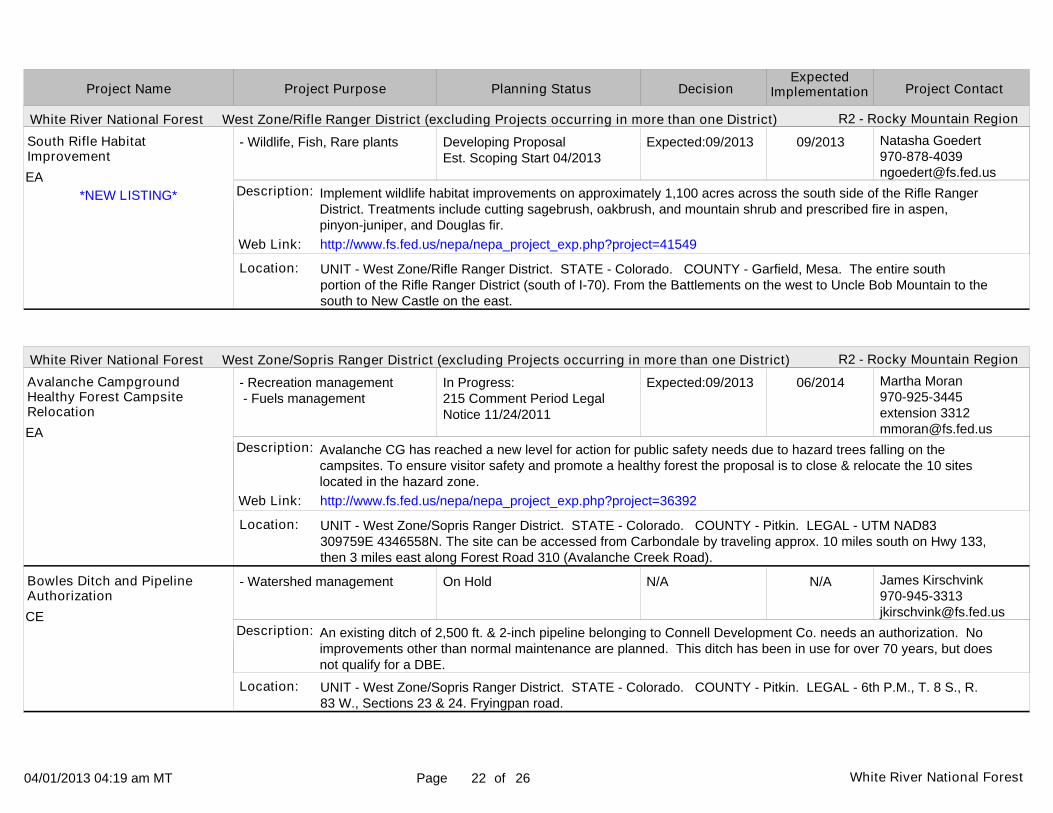
UNIT - West Zone/Rifle Ranger District. STATE - Colorado. COUNTY - Garfield, Mesa. The entire south portion of the Rifle Ranger District (south of I-70). From the Battlements on the west to Uncle Bob Mountain to the south to New Castle on the east.
UNIT - West Zone/Sopris Ranger District. STATE - Colorado. COUNTY - Pitkin. LEGAL - UTM NAD83 309759E 4346558N. The site can be accessed from Carbondale by traveling approx. 10 miles south on Hwy 133, then 3 miles east along Forest Road 310 (Avalanche Creek Road).
UNIT - West Zone/Sopris Ranger District. STATE - Colorado. COUNTY - Pitkin. LEGAL - 6th P.M., T. 8 S., R. 83 W., Sections 23 & 24. Fryingpan road.
Location:
Location:
Location:
09/2013
06/2014
N/A
South Rifle Habitat Improvement
Avalanche Campground Healthy Forest Campsite Relocation
Bowles Ditch and Pipeline Authorization
Implement wildlife habitat improvements on approximately 1,100 acres across the south side of the Rifle Ranger District. Treatments include cutting sagebrush, oakbrush, and mountain shrub and prescribed fire in aspen, pinyon-juniper, and Douglas fir.
Avalanche CG has reached a new level for action for public safety needs due to hazard trees falling on the campsites. To ensure visitor safety and promote a healthy forest the proposal is to close & relocate the 10 sites located in the hazard zone.
An existing ditch of 2,500 ft. & 2-inch pipeline belonging to Connell Development Co. needs an authorization. No improvements other than normal maintenance are planned. This ditch has been in use for over 70 years, but doesnot qualify for a DBE.
Description:
Description:
Description:
Web Link:
Web Link:
http://www.fs.fed.us/nepa/nepa_project_exp.php?project=41549
http://www.fs.fed.us/nepa/nepa_project_exp.php?project=36392
*NEW LISTING*EA
EA
CE
04/01/2013 04:19 am MT Page of23 White River National Forest 26
White River National Forest West Zone/Sopris Ranger District (excluding Projects occurring in more than one District)
Project PurposeProject Name DecisionPlanning Status Project ContactExpected
Implementation
R2 - Rocky Mountain Region
- Forest products
- Special use management
- Land ownership management
In Progress:215 Comment Period Legal Notice 10/04/2012
In Progress:Scoping Start 02/27/2009Est. 215 Comment Period LegalNotice 08/2013
In Progress:Scoping Start 12/01/2011Est. 215 Comment Period LegalNotice 09/2013
Expected:04/2013
Expected:09/2013
Expected:11/2013
Steven [email protected]
James [email protected]
Kevin [email protected]
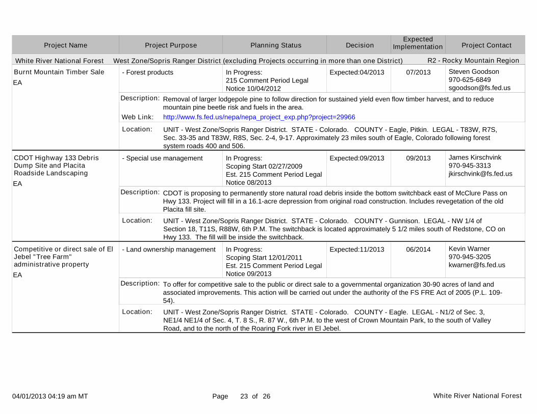
UNIT - West Zone/Sopris Ranger District. STATE - Colorado. COUNTY - Eagle, Pitkin. LEGAL - T83W, R7S, Sec. 33-35 and T83W, R8S, Sec. 2-4, 9-17. Approximately 23 miles south of Eagle, Colorado following forest system roads 400 and 506.
UNIT - West Zone/Sopris Ranger District. STATE - Colorado. COUNTY - Gunnison. LEGAL - NW 1/4 of Section 18, T11S, R88W, 6th P.M. The switchback is located approximately 5 1/2 miles south of Redstone, CO on Hwy 133. The fill will be inside the switchback.
UNIT - West Zone/Sopris Ranger District. STATE - Colorado. COUNTY - Eagle. LEGAL - N1/2 of Sec. 3, NE1/4 NE1/4 of Sec. 4, T. 8 S., R. 87 W., 6th P.M. to the west of Crown Mountain Park, to the south of Valley Road, and to the north of the Roaring Fork river in El Jebel.
Location:
Location:
Location:
07/2013
09/2013
06/2014
Burnt Mountain Timber Sale
CDOT Highway 133 Debris Dump Site and Placita Roadside Landscaping
Competitive or direct sale of El Jebel "Tree Farm" administrative property
Removal of larger lodgepole pine to follow direction for sustained yield even flow timber harvest, and to reduce mountain pine beetle risk and fuels in the area.
CDOT is proposing to permanently store natural road debris inside the bottom switchback east of McClure Pass onHwy 133. Project will fill in a 16.1-acre depression from original road construction. Includes revegetation of the old Placita fill site.
To offer for competitive sale to the public or direct sale to a governmental organization 30-90 acres of land and associated improvements. This action will be carried out under the authority of the FS FRE Act of 2005 (P.L. 109-54).
Description:
Description:
Description:
Web Link: http://www.fs.fed.us/nepa/nepa_project_exp.php?project=29966
EA
EA
EA
04/01/2013 04:19 am MT Page of24 White River National Forest 26
White River National Forest West Zone/Sopris Ranger District (excluding Projects occurring in more than one District)
Project PurposeProject Name DecisionPlanning Status Project ContactExpected
Implementation
R2 - Rocky Mountain Region
- Land ownership management
- Watershed management
- Minerals and Geology
Cancelled
Developing ProposalEst. Scoping Start 04/2013
In Progress:215 Comment Period Legal Notice 03/28/2013
N/A
Expected:06/2013
Expected:04/2013
Kevin [email protected]
Mark [email protected]
Olivia [email protected]
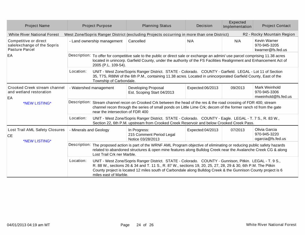
UNIT - West Zone/Sopris Ranger District. STATE - Colorado. COUNTY - Garfield. LEGAL - Lot 11 of Section 35, T7S, R88W of the 6th P.M., containing 11.38 acres. Located in unincorporated Garfield County, East of the Township of Carbondale.
UNIT - West Zone/Sopris Ranger District. STATE - Colorado. COUNTY - Eagle. LEGAL - T. 7 S., R. 83 W., Section 22, 6th P.M. upstream from Crooked Creek Reservoir and below Crooked Creek Pass.
UNIT - West Zone/Sopris Ranger District. STATE - Colorado. COUNTY - Gunnison, Pitkin. LEGAL - T. 9 S., R. 88 W., sections 26 & 34 and T. 11 S., R. 87 W., sections 19, 20, 25, 27, 28, 29 & 30, 6th P.M. The Pitkin County project is located 12 miles south of Carbondale along Bulldog Creek & the Gunnison County project is 6 miles east of Marble.
Location:
Location:
Location:
N/A
09/2013
07/2013
Competitive or direct sale/exchange of the Sopris Pasture Parcel
Crooked Creek stream channel and wetland restoration
Lost Trail AML Safety Closures
To offer for competitive sale to the public or direct sale or exchange an admin/ use parcel comprising 11.38 acres located in unincorp. Garfield County, under the authority of the FS Facilities Realignment and Enhancement Act of 2005 (P.L. 109-54).
Stream channel recon on Crooked Crk between the head of the res & the road crossing of FDR 400; stream channel recon through the series of small ponds on Little Lime Crk; decom of the former ranch rd from the gate near the intersection of FDR 400
The proposed action is part of the WRNF AML Program objective of eliminating or reducing public safety hazards related to abandoned structures & open mine features along Bulldog Creek near the Avalanche Creek CG & along Lost Trail Crk ner Marble.
Description:
Description:
Description:
*NEW LISTING*
*NEW LISTING*
EA
EA
CE
04/01/2013 04:19 am MT Page of25 White River National Forest 26
White River National Forest West Zone/Sopris Ranger District (excluding Projects occurring in more than one District)
Project PurposeProject Name DecisionPlanning Status Project ContactExpected
Implementation
R2 - Rocky Mountain Region
- Wildlife, Fish, Rare plants - Fuels management
- Road management
- Special use management
In Progress:215 Comment Period Legal Notice 06/28/2012
In Progress:215 Comment Period Legal Notice 05/04/2012
Developing ProposalEst. NOI in Federal Register 09/2013
Expected:04/2013
Expected:09/2013
Expected:07/2014
Philip [email protected]
James [email protected]
James [email protected]
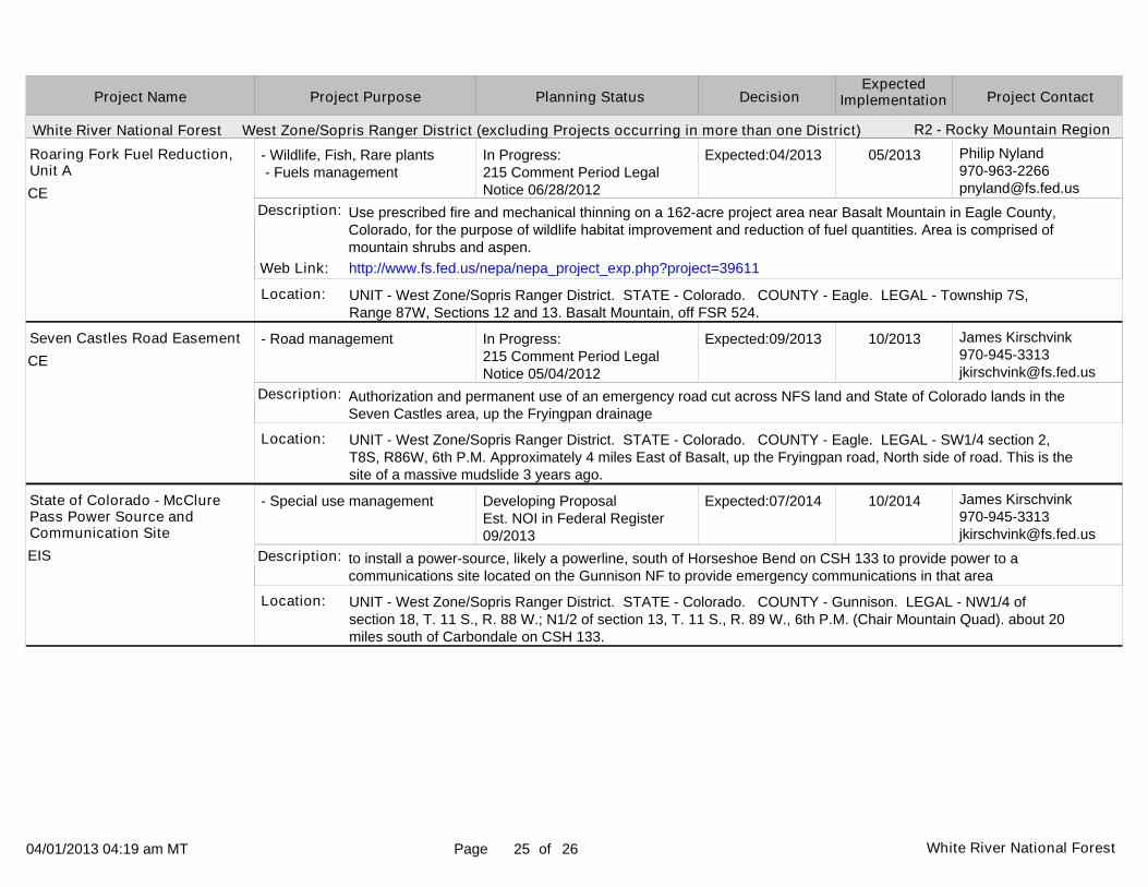
UNIT - West Zone/Sopris Ranger District. STATE - Colorado. COUNTY - Eagle. LEGAL - Township 7S, Range 87W, Sections 12 and 13. Basalt Mountain, off FSR 524.
UNIT - West Zone/Sopris Ranger District. STATE - Colorado. COUNTY - Eagle. LEGAL - SW1/4 section 2, T8S, R86W, 6th P.M. Approximately 4 miles East of Basalt, up the Fryingpan road, North side of road. This is the site of a massive mudslide 3 years ago.
UNIT - West Zone/Sopris Ranger District. STATE - Colorado. COUNTY - Gunnison. LEGAL - NW1/4 of section 18, T. 11 S., R. 88 W.; N1/2 of section 13, T. 11 S., R. 89 W., 6th P.M. (Chair Mountain Quad). about 20 miles south of Carbondale on CSH 133.
Location:
Location:
Location:
05/2013
10/2013
10/2014
Roaring Fork Fuel Reduction, Unit A
Seven Castles Road Easement
State of Colorado - McClure Pass Power Source and Communication Site
Use prescribed fire and mechanical thinning on a 162-acre project area near Basalt Mountain in Eagle County, Colorado, for the purpose of wildlife habitat improvement and reduction of fuel quantities. Area is comprised of mountain shrubs and aspen.
Authorization and permanent use of an emergency road cut across NFS land and State of Colorado lands in the Seven Castles area, up the Fryingpan drainage
to install a power-source, likely a powerline, south of Horseshoe Bend on CSH 133 to provide power to a communications site located on the Gunnison NF to provide emergency communications in that area
Description:
Description:
Description:
Web Link: http://www.fs.fed.us/nepa/nepa_project_exp.php?project=39611
CE
CE
EIS
04/01/2013 04:19 am MT Page of26 White River National Forest 26
The U.S. Department of Agriculture (USDA) prohibits discrimination in all its programs and activities on the basis of race, color, national origin, age, disability, and where applicable, sex, marital status, familial status, parental status, religion, sexual orientation, genetic information, political beliefs, reprisal, or because all or part of an individual's income is derived from any public assistance program. (Not all prohibited bases apply to all programs.) Persons with disabilities who require alternative means for communication of program information (Braille, large print, audiotape, etc.) should contact USDA's TARGET Center at (202) 720-2600 (voice and TDD).
To file a complaint of discrimination, write USDA, Director, Office of Civil Rights, 1400 Independence Avenue, SW, Washington, DC 20250-9410 or call (800) 795-3272 (voice) or (202) 720-6382 (TDD). USDA is an equal opportunity provider and employer.
This report contains the best available information at the time of publication. Questions may be directed to the Project Contact.
Project PurposeProject Name DecisionPlanning Status Project ContactExpected
Implementation