Embed Size (px)
Citation preview
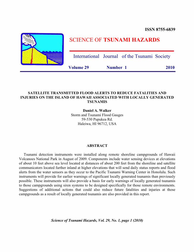
ISSN 8755-6839
SCIENCE OF TSUNAMI HAZARDS
International Journal of the Tsunami Society
Volume 29 Number 1 2010
SATELLITE TRANSMITTED FLOOD ALERTS TO REDUCE FATALITIES AND
INJURIES ON THE ISLAND OF HAWAII ASSOCIATED WITH LOCALLY GENERATED
TSUNAMIS
Daniel A. Walker
Storm and Tsunami Flood Gauges
59-530 Pupukea Rd.
Haleiwa, HI 96712, USA
ABSTRACT
Tsunami detection instruments were installed along remote shoreline campgrounds of Hawaii
Volcanoes National Park in August of 2009. Components include water sensing devices at elevations
of about 10 feet above sea level located at distances of about 200 feet from the shoreline and satellite
communicators located further inland at higher elevations that will send daily status reports and flood
alerts from the water sensors as they occur to the Pacific Tsunami Warning Center in Honolulu. Such
instruments will provide for earlier warnings of significant locally generated tsunamis than previously
possible. These instruments will also provide a basis for early warnings of locally generated tsunamis
to those campgrounds using siren systems to be designed specifically for those remote environments.
Suggestions of additional actions that could also reduce future fatalities and injuries at those
campgrounds as a result of locally generated tsunamis are also provided in this report.
Science of Tsunami Hazards, Vol. 29, No. 1, page 1 (2010)
1. INTRODUCTION
Data for all of the reported significant locally generated tsunamis in the Hawaiian Islands during
the 20th
century are shown in Figures 1 and 2. A significant tsunami is considered here to be a tsunami
with a runup of three or more feet. Runup is a measure of the tsunami’s maximum vertical wave
height on land relative to mean sea level. Inundation is a measure of the tsunami’s maximum
horizontal inland penetration. Also shown are data for the largest known and best documented local
tsunami of the 19th
century in Figure 3. No significant locally generated tsunamis have occurred in the
Hawaiian Islands thus far in the 21st century and there are no reports of any local tsunamis having
significant runups on any island other than the Big Island.
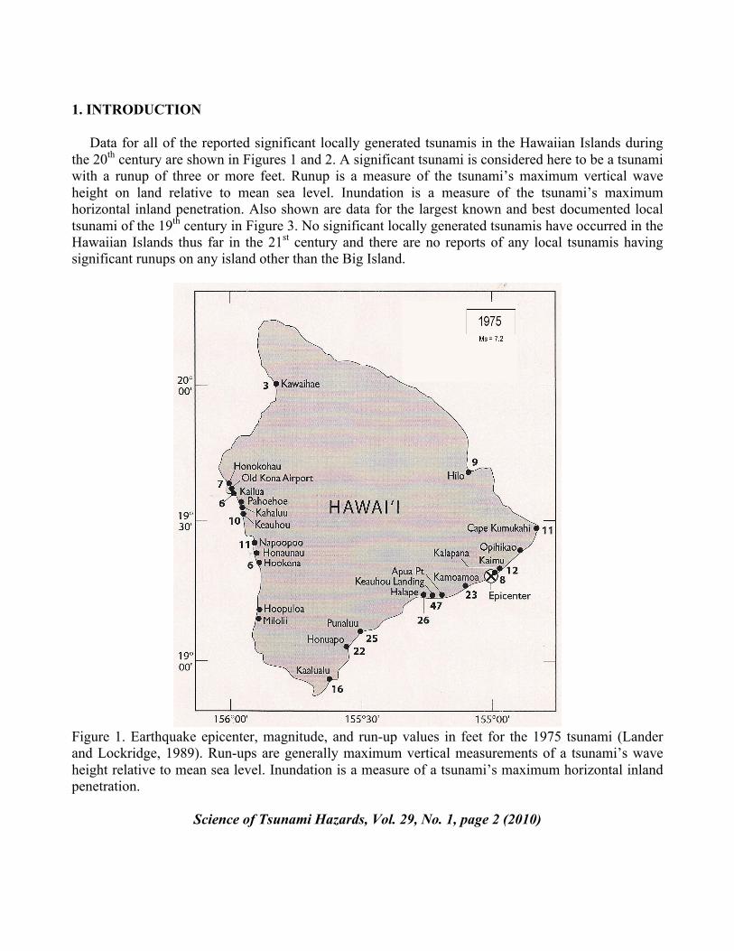
Figure 1. Earthquake epicenter, magnitude, and run-up values in feet for the 1975 tsunami (Lander
and Lockridge, 1989). Run-ups are generally maximum vertical measurements of a tsunami’s wave
height relative to mean sea level. Inundation is a measure of a tsunami’s maximum horizontal inland
penetration.
Science of Tsunami Hazards, Vol. 29, No. 1, page 2 (2010)
Note that some tsunamis (Figure 2) have occurred as a result of relatively small or unfelt earthquakes.
Also, another possible unfelt earthquake generating a tsunami is one that may have occurred in 1869
with a run-up of about 27 feet between Pohoiki and Opihikao and inundation of about 800 feet (Cox
and Morgan, 1977; and personal communication). Of the 23 Big Island earthquakes in the 20th
century
(Klein et al. 2001) with magnitudes of 6.0 or greater plus the 15 October 2006 earthquake near
Kiholo, only the three shown in Figures 1 and 2 generated significant tsunamis. All of the foregoing
data indicates that earthquake magnitudes are not reliable indicators of tsunamigenic potential. A
better indicator would be actual evidence of a tsunami washing inland soon after the recording of a
nearby earthquake.
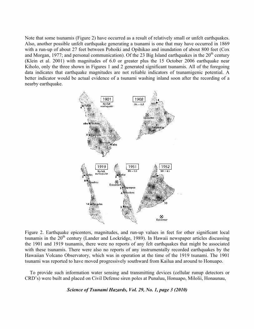
Figure 2. Earthquake epicenters, magnitudes, and run-up values in feet for other significant local
tsunamis in the 20th
century (Lander and Lockridge, 1989). In Hawaii newspaper articles discussing
the 1901 and 1919 tsunamis, there were no reports of any felt earthquakes that might be associated
with these tsunamis. There were also no reports of any instrumentally recorded earthquakes by the
Hawaiian Volcano Observatory, which was in operation at the time of the 1919 tsunami. The 1901
tsunami was reported to have moved progressively southward from Kailua and around to Honuapo.
To provide such information water sensing and transmitting devices (cellular runup detectors or
CRD’s) were built and placed on Civil Defense siren poles at Punaluu, Honuapo, Milolii, Honaunau,
Science of Tsunami Hazards, Vol. 29, No. 1, page 3 (2010)
Napoopoo, Kahaluu, Pahoehoe Park, and the old Kona airport (Figure 4; Walker and Cessaro, 2002).
Although these instruments complement the Pacific Tsunami Warning Center’s (PTWC) sea level
gauges at Kapoho, Honuapo, Milolii, and Honokohau, neither CRD’s nor sea level gauges exist in the
highly seismically active region of the Big Island extending from Punaluu to PTWC’s sea level gauge
at Kapoho. Much of this region is within the boundaries of Hawaii Volcanoes National Park (HAVO)
with no roads, power, or civil defense siren poles. The largest locally generated tsunamis in Hawaii’s
history occurred in this region (Figures 1 and 3). Therefore tsunami detection instruments in these
areas could provide for earlier, life saving warnings for heavily used parks to the north (Pohoiki and
Ahalanui) and south (Punaluu and Honuapo). Also, much earlier warnings for the Hilo area and the
Kona coast would be possible.
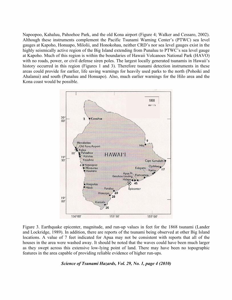
Figure 3. Earthquake epicenter, magnitude, and run-up values in feet for the 1868 tsunami (Lander
and Lockridge, 1989). In addition, there are reports of the tsunami being observed at other Big Island
locations. A value of 7 feet indicated for Apua may not be consistent with reports that all of the
houses in the area were washed away. It should be noted that the waves could have been much larger
as they swept across this extensive low-lying point of land. There may have been no topographic
features in the area capable of providing reliable evidence of higher run-ups.
Science of Tsunami Hazards, Vol. 29, No. 1, page 4 (2010)
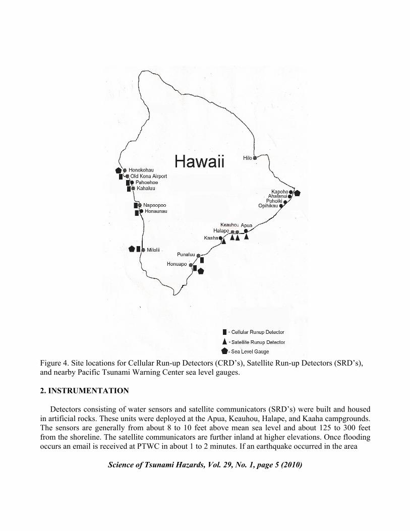
Figure 4. Site locations for Cellular Run-up Detectors (CRD’s), Satellite Run-up Detectors (SRD’s),
and nearby Pacific Tsunami Warning Center sea level gauges.
2. INSTRUMENTATION
Detectors consisting of water sensors and satellite communicators (SRD’s) were built and housed
in artificial rocks. These units were deployed at the Apua, Keauhou, Halape, and Kaaha campgrounds.
The sensors are generally from about 8 to 10 feet above mean sea level and about 125 to 300 feet
from the shoreline. The satellite communicators are further inland at higher elevations. Once flooding
occurs an email is received at PTWC in about 1 to 2 minutes. If an earthquake occurred in the area
Science of Tsunami Hazards, Vol. 29, No. 1, page 5 (2010)
just prior to the email receipt, confirmation of a significant tsunami should be assumed and warnings
immediately issued. The instruments have been designed and tested to run on primary lithium
batteries for at least one year without maintenance.
Another device that was installed at the Halape site was a “campground siren system”. This device
consists of a water sensor and siren, each mounted in an artificial rock. These also have been built and
tested to run on primary lithium ion batteries for at least one year without maintenance. However,
because of the extensive lateral distribution and the shoreline proximity of the individual campsites at
each of the four campgrounds described below, design modifications of the existing “campground
siren system” will be required.
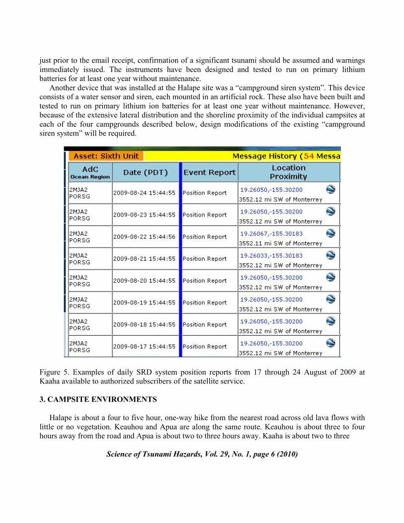
Figure 5. Examples of daily SRD system position reports from 17 through 24 August of 2009 at
Kaaha available to authorized subscribers of the satellite service.
3. CAMPSITE ENVIRONMENTS
Halape is about a four to five hour, one-way hike from the nearest road across old lava flows with
little or no vegetation. Keauhou and Apua are along the same route. Keauhou is about three to four
hours away from the road and Apua is about two to three hours away. Kaaha is about two to three
Science of Tsunami Hazards, Vol. 29, No. 1, page 6 (2010)
hours from its nearest road down a steep rubble switchback and across a plateau of lava flows gently
sloping towards the ocean.
At all four campgrounds, campers predominantly pitch their tents or sleeping bags on the beach
because of the beauty of that environment and because of necessity. These campsites are generally
within 100 feet of the shoreline at elevations less than 6 feet above sea level. The sand provides a flat,
smooth surface, unlike the irregular rocky surfaces further inland. These individual beach campsites
are in some instances spread out over several hundred feet of the shoreline, often under any available
cluster of trees, providing ample opportunities for privacy. A single, approximate 12-foot by 12 foot
shelter with a smooth dirt floor does exist at each of the Keauhou, Halape, and Kaaha camping areas.
At distances of more than a thousand feet from the shoreline and elevations generally more than 50
feet above sea level, these shelters are well located outside of the inundation zone for even the largest
tsunamis. If the campers were aware of the detailed history of tsunamis at these sites, some would opt
for the shelters, at least for sleeping, rather than the beach. However, with overcrowding (i.e., perhaps
as little as more than two tents) the relatively small but safe shelters cannot compete with the
numerous private sites at the shorelines.
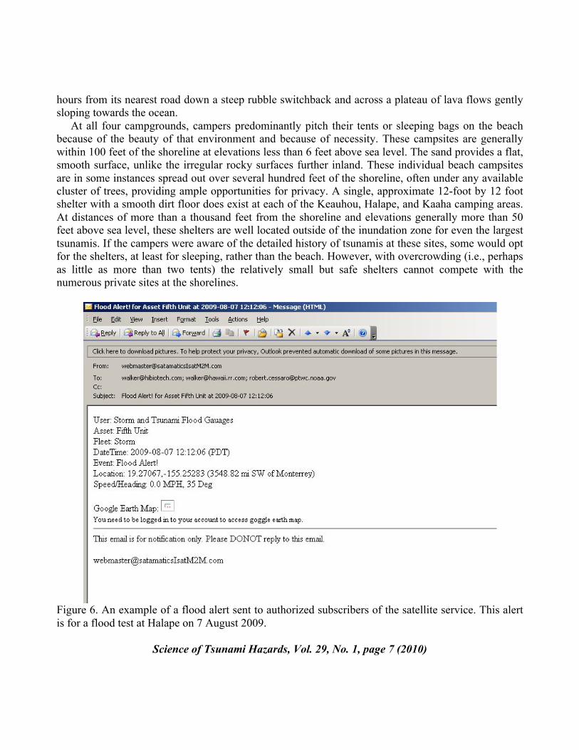
Figure 6. An example of a flood alert sent to authorized subscribers of the satellite service. This alert
is for a flood test at Halape on 7 August 2009.
Science of Tsunami Hazards, Vol. 29, No. 1, page 7 (2010)
The sensor for the “campground siren system” installed at Halape is only a couple of feet below the
elevation of most of the shoreline campsites, so it may, in most instances, provide for warnings of
little value. Were the campsites further inland, at higher elevations, and not so widely distributed
along the beach, such a system could be more effective. At Apua, Keauhou, and Kaaha there were no
locations for which the existing “campground siren system” could serve any useful purpose. It will be
important to monitor the survivability of the “campground siren system” and the four SRD systems in
terms of heat, rain, insects, rodents, and humans. A unit on Oahu in a cooler, wetter environment with
potentially less insect, rodent, or human interaction has thus far (through August 2009) operated
without any problems or required battery changes for 10 months, giving daily position reports (Figure
5) and numerous flood alert test messages (Figure 6) during this time period.
4. CONCLUSIONS AND RECOMMENDATIONS
Until more information is gathered on the reliability of the SRD systems in field operations, the
absence of a flood alert should not be used as evidence that water did not flood a sensor. However, if
a unit has generally been giving daily position reports and a flood alert was received shortly after a
nearby earthquake was recorded, a warning should be issued immediately for the Big Island and
modified accordingly as other data is received.
Although the systems installed at the shoreline campgrounds will provide earlier and more reliable
warnings for areas outside HAVO via civil defense sirens, there is at present no effective way to warn
visitors to these campgrounds of impending local or Pacific-wide tsunamis. However, the technology
already exists to provide such warnings. The SRD systems now installed at the shoreline
campgrounds will provide early evidence of a local tsunami. Each of the four campgrounds has a
toilet building in which a powerful siren could be mounted and remotely triggered by Civil Defense or
HAVO using the same type of satellite communicator that detected the initial tsunami inundation.
Make no mistake – if the earliest detectable landfall of a significant tsunami is at one of HAVO’s
shoreline campgrounds there could be fatalities and injuries. This could occur for a felt earthquake if
visitors stayed to watch or pick up fish. Or it could occur if they were at the beach and the tsunami
was generated by a smaller unfelt earthquake that may have triggered a large submarine landslide.
However, campers at adjacent campgrounds might be saved if the initial detected flooding results in
sirens being turned on at those other campgrounds before the tsunami strikes.
Additional tsunami detection instruments near the margins of HAVO’s shoreline boundaries
further to the north and further to the south could also improve the speed with which warnings could
be given at the campgrounds for some local tsunamis if inundation occurs at those more northerly or
southerly locations prior to inundations at any of the shoreline campgrounds. Such locations for
additional instruments could be critical for more timely warnings for areas to the north (Pohoiki,
Ahalanui, and on to Hilo) and to the south (Punaluu, Honuapo, and on to the Kona Coast).
There are risks associated with everyday activities and special risks may be associated with hiking
and camping in our national parks. HAVO is no exception. Hikers and campers need to be aware of
special risks and reasonable efforts should be taken to reduce such risks. Visitors to shoreline areas
need to be advised of the risks posed by tsunamis. Some information is already provided to them
when they apply for their backcountry permits. Such information should be accurate, comprehensive,
and updated as new equipment is placed in the field or as warning systems evolve. Also, shelters
Science of Tsunami Hazards, Vol. 29, No. 1, page 8 (2010)
should be safely located outside of tsunami inundation zones. The existing shelters fulfill this
requirement. However, considering environmental and budgetary constraints, as well as other
priorities, more safe campsites at Apua, Keauhou, Halape, and Kaaha should be considered. These
could consist of nothing more than a couple of roof panels, dirt flooring, and supporting 2 x 4’s or 4 x
4’s. Such shelters could be used for sleeping at night when campers would be most vulnerable to an
unfelt but dangerous local tsunami. These shelters would provide the level flooring that is nearly
impossible to find anywhere but near the shoreline and at the single safe inland shelters at Keauhou,
Halape, and Kaaha. Adding lean-to’s to either side of the existing inland shelters or simple
commercially available shelters are another possibility. An extreme minimalist but workable solution
could be the mere landscaping of several flat dirt areas scattered sufficiently inland to provide safety
and privacy. These “tsunami safe sleeping areas” could be indicated by ahu’s (stacked rocks) and their
use for safe sleeping should be encouraged. Although many campers may continue to take their
chances sleeping at the beach, with sufficient inland campsites, comprehensive information, and
adequate warnings given, responsible action would have been taken by HAVO to prevent any tsunami
fatalities or injuries.
5. SUMMARY
5.1 Tsunami detection and flood alert satellite transmission instruments have been installed at Apua
Point, Keauhou Landing, Halape, and Kaaha capable of providing earlier warnings of locally
generated tsunamis for portions of the Big Island.
5.2 Additional instruments should be installed near the margins of HAVO’s boundaries for more
comprehensive and necessary coverage.
5.3 The “campground siren system” installed at Halape needs to be modified with satellite remote
control capabilities and a louder siren for all campgrounds.
5.4 In conjunction with a satellite remote controlled siren system, the recently installed detection
instruments can also provide the basis for warnings of locally generated and Pacific-wide tsunamis at
those campgrounds.
5.5 The long term effects of the environment on these installations needs to be evaluated. As such, in
the near term, the absence of detected inundation after the occurrence of a nearby earthquake should
not be used to infer that a significant tsunami has not occurred.
5.6 However, the detection of inundation after a nearby earthquake should trigger an immediate
warning for the Big Island that could be discontinued or expanded as data is received from other
instruments.
5.7 Visitors to the campgrounds should receive comprehensive, accurate, and up-to-date information
on tsunami hazards.
Science of Tsunami Hazards, Vol. 29, No. 1, page 9 (2010)
5.8 Consideration should be given to expanding existing shelters, adding more small individual
shelters, or landscaping “tsunami safe sleeping areas” inland and at higher elevations outside of the
tsunami inundation zones sufficiently, in terms of privacy or structure, to encourage nighttime use.
The steps taken thus far by HAVO to address tsunami issues represent reasonable and responsible
efforts to protect visitors in shoreline areas from tsunami hazards. Further actions suggested in this
report should be considered to complete this task.
Acknowledgements
The construction and installation of the instruments was supported by funding given to the State of
Hawaii’s Civil Defense Agency by the National Tsunami Hazards Mitigation Program. The work
involved was a cooperative effort involving State Civil Defense, the Pacific Tsunami Warning Center,
the Hawaii County Civil Defense Agency, Hawaii Volcanoes National Park, and the Hawaiian
Volcano Observatory.
REFERENCES
Cox, D.C., and Morgan, J. (1977). Local Tsunamis and Possible Local Tsunamis in Hawaii, HIG-77-
14, Hawaii Inst. of Geophysics, 118 pp.
Lander, J.F., and Lockridge, P.A. (1989). United States Tsunamis (including United States
possessions) 1690-1988, National Geophysical Data Center, Publication 41-2, Boulder, Colorado, 265
pp.
Klein, F.W., Frankel, A.D., Mueller, C.S., Wesson, R.L., and Okubo, P.G. (2001). Seismic Hazard in
Hawaii: High Rate of Large Earthquakes and Probabilistic Ground Motion Maps, Bull. Seismol. Soc.
Amer., 91, 479 - 498.
Walker, D.A., and Cessaro, R.K. (2002). Locally Generated Tsunamis in Hawaii: A Low Cost, Real
Time Warning System with World Wide Applications, Sci. Tsunami Haz. 20, 4, 177 - 182.
Science of Tsunami Hazards, Vol. 29, No. 1, page 10 (2010)