Embed Size (px)
Citation preview
Flood Risk Management Strategy
SCOPING STUDY
May 2009

Issue box
Version Issue Date Issued by Issued to Amendments from previous version
Version 1.0
09/03/2009 K.Chandler K.Jacques (B&NES) None - first draft for comment
Version 2.0
06/04/09 K.Chandler K.Jacques, K.Jenner (B&NES) B&NES comments dated 31/03/09, Level 2 SFRA Flood Zones, description of sensitivity testing
Final 26/05/09 K.Chandler K.Jacques (B&NES) N/A
Capita Symonds House Wood Street East Grinstead RH19 3LS
Tel: +44 (0)1342 333 226 Fax: +44 (0)1342 315 927
Project manager: Kristy Chandler Project director: Alastair Dale
www.capitasymonds.co.uk

Contents
Executive Summary ................................................................................................ iii
1. Introduction...................................................................................................... 1
2. Approach.......................................................................................................... 2
3. Problem synopsis............................................................................................ 6
4. Option identification.......................................................................................12
5. Success criteria ..............................................................................................16
6. Outline appraisal ............................................................................................21
7. Conclusions and recommendations.............................................................24
Appendix A – Maps
Appendix B – Flood Risk Management Options
Appendix C – Outline Appraisal
Appendix D – Calculation Matrices
Appendix E – Cost calculations
Flood Risk Management Strategy - Scoping Study May 2009 i

Appendix A - Maps Map 1 Location and Current Flood Zones 2 and 3
Map 2 Current and Future Flood Zone 3
Map 3 Existing FRM infrastructure in B&NES
Map 3a Existing FRM infrastructure in Bath
Map 3b Existing FRM infrastructure in Keynsham
Map 3c Existing FRM infrastructure in Midsomer Norton / Radstock
Map 4a Bristol Avon CFMP Policy
Map 4b Bristol Avon CFMP Actions
Map 5 Other FRM options included in previous studies
Map 6 FRM options not included in previous studies
Map 7 All FRM options identified in B&NES
Map 7a All FRM options identified in Bath
Map 7b All FRM options identified in Keynsham
Map 7c All FRM options identified in Midsomer Norton / Radstock
Map 8 Environmental designations
Map 9 BAP habitats
Flood Risk Management Strategy - Scoping Study May 2009 ii

Executive Summary
Executive Summary Capita Symonds was commissioned by Bath and North East Somerset (B&NES) to undertake a Scoping Study for the preparation of a Flood Risk Management (FRM) Strategy in support of their Local Development Framework (LDF). The objectives of the Scoping Study were to:
• identify a wide range of possible options for flood risk management; • highlight where these options have been investigated previously and where further work is
required; and • provide an initial assessment of the options and recommendations for the next stage of
Strategy development.
The approach adopted in the Scoping Study was broadly based on the principles outlined in the Flood and Coastal Defence Project Appraisal Guidance (FCDPAG), although it is recognised that the FCDPAG is not strictly applicable (the guidance was not developed for the appraisal of FRM options for land-use planning purposes). The key steps in preparing the Scoping Report were:
1. Problem synopsis - including key drivers and scope of FRM Strategy. 2. Identify strategic options - based on a review of options investigated previously and the
identification of other options that may have be applicable. 3. Establish success criteria - according to technical feasibility, economical viability,
environmental and social acceptability and deliverability. Each success criteria was weighted accordingly to its relative importance. A consultation meeting was held to ascertain the priorities placed on each criteria by the key stakeholders (B&NES, Environment Agency).
4. Outline comparison of options - the options were assessed relative to three 'critical areas' - Bath, Keynsham, Midsomer Norton/Radstock, using the success criteria and weighting established during the Scoping Study.
5. Conclusions and recommendations - were prepared for the main stage of FRM Strategy development.
The preferred options for the 'critical areas' were found to be:
• Bath - raise and formalise existing flood defences along the River Avon, in combination with flood resilient design and a storage area downstream of the City to offset loss of floodplain capacity.
• Keynsham - ground raising or raised defences within proposed development sites, in combination with flood resilient design (for raised defences only) and a flood storage area to offset loss of floodplain capacity. There is an opportunity to incorporate the floodplain storage area downstream of the Cadburys site and/or the flood storage area identified downstream of Bath.
• Midsomer Norton / Radstock - raised defences or ground raising in individual development sites on the Wellow Brook in combination with floodplain storage to offset loss of floodplain capacity. One floodplain storage area upstream of the urban area on the Wellow Brook could offset the composite loss.
The methodology for selecting these preferred options was broad scale and as such it is recommended that the non-preferred options be reconsidered in light of new information that will emerge during the main stage.
Flood Risk Management Strategy - Scoping Study May 2009 iii

Introduction
1. Introduction
1.1. In preparing their Local Development Framework, Bath and North East Somerset (B&NES) Council has identified the need for a Flood Risk Management (FRM) Strategy to support their Core Strategy. This follows on from the findings of their Level 1 and Level 2 Strategic Flood Risk Assessments (SFRA) which showed that a number of potential regeneration and development areas area at risk of flooding today or would likely become at risk of flooding in the future due to climate change.
1.2. In accordance with Planning Policy Statement 25: Development and Flood Risk (PPS25), the Council will, where possible, seek to allocate development on land with a low probability of flooding (Flood Zone 1). However it is unlikely that the Council will be able to achieve the development aims outlined in it’s vision described in the Future for Bath and North East Somerset and in the South West Regional Spatial Strategy (RSS) without needing to balance flood risk against other planning considerations.
1.3. Should the Council demonstrate through the application of the Sequential Test the need to allocate land within the floodplain, they must to show that it would be safe for the development lifetime and that the development can be implemented within the plan period. This is the primary driver of the FRM Strategy considered by this Scoping Report.
1.4. The Council are aware of several existing studies to examine FRM options in B&NES, ranging from the high level draft Bristol Avon Catchment Flood Management Plan (CFMP) to the more detailed Bath Flood Defence Study. These studies have looked at various flood risk management options in various levels of detail. None have looked at a combination of strategic and site specific options to manage flood risk across B&NES.
1.5. Before commencing the FRM Strategy, the Council commissioned Capita Symonds to undertake a Scoping Study to capture the outcomes from previous work and use this exercise to direct the development of the FRM Strategy. This report summarises the findings of the Scoping study, which aims to:
• Summarise the FRM options that have been investigated in previous studies;
• Identify alternative FRM options that have not been included in previous studies;
• Establish a set of outline criteria against which the FRM options could be appraised;
• Undertake an outline appraisal; and
• Make recommendations for the main stage of the Strategy.
Flood Risk Management Strategy - Scoping Study May 2009
1

Approach
2. Approach
The need for a strategy 2.1. FRM in B&NES is driven by two key processes, as shown in Figure 2.1:
• Land-Use Planning: LDF prepared by B&NES; and
• Flood Risk Management Planning: Bristol Avon CFMP prepared by the Environment Agency (draft available for use in the Scoping Study).
FRM STRATEGY
(Adapted from the draft Bristol Avon CFMP, Environment Agency 2008)
Figure 2.1 Broader context of the Flood Risk Management Strategy for B&NES
Flood Risk Management Strategy - Scoping Study May 2009
2

Approach
2.2. The FRM Strategy covered by this Scoping Study is primarily driven by the Land-Use Planning process (Local Development Framework). It is beneficial for B&NES Council to understand how their FRM Strategy will align with other initiatives currently promoted by the Flood Risk Management Planning process (Environment Agency). Figure 2.1 shows the potential area of overlap between the two strategic set of activities.
2.3. B&NES Council have chosen to prepare a FRM Strategy, instead of promoting site specific FRM investigations as:
• it is likely that several small development areas will benefit from one integrated FRM system;
• the impacts of FRM works are likely to extend over a wide area (particularly on the River Avon);
• there are opportunities for joint working with other organisations/departments to help the Council achieve some of its other objectives (i.e. reduce flood risk to existing development and environmental/social enhancements); and
• it is possible that the mitigation works required for individual sites could not be implemented at each particular location. Thus there is a need to consider provisions for mitigation measures remote from the allocation sites so that any measures to make new development safe do not have an adverse impact on third parties.
Guidance and stages in strategy development 2.4. Traditionally all capital works undertaken by the Environment Agency or B&NES
Council for FRM purposes would have been funded from general taxation. The Department for Environment, Food and Rural Affairs (Defra) developed the Flood and Coastal Defence Project Appraisal Guidance (FCDPAG) to assist the economic, social and environmental appraisal of nationally funded FRM options for the protection of existing development.
2.5. The broad principles outlined in FCDPAG have been followed when preparing this Scoping Study, however it is recognised that the guidance itself is not strictly applicable as this FRM Strategy is primarily driven by the land-use planning process for new development.
2.6. Figure 2.2 outlines the main stages of strategy development. The Scoping Study has commenced the first two stages of strategy development (define and develop) and provides initial guidance to be considered in the latter three stages.
Flood Risk Management Strategy - Scoping Study May 2009
3

Approach
1. DEFINE Define the problem
Establish strategic aims and objectives
Data collection 2. DEVELOP
Identify key issues
Identify all the options
Eliminate unreasonable options
Determine success criteria
3. COMPARE Compare options
Test the robustness of the choice
Select the best options
4. SELECT Agree preferred option
5. COMPILATION Prepare strategy plan
CO
NSU
LTA
TIO
N
FRM
SC
OPI
NG
STU
DY
Figure 2.2 Stages in strategy development
Consultation 2.7. Consultation is important in the development of any strategy and as such it is
anticipated that a formal Consultation Group will be established during the main stage of FRM Strategy development. Initial consultation feedback was obtained during the Scoping Study via a consultation meeting which was comprised of members of the following organisations/departments:
• B&NES – Planning Policy;
• B&NES – Development and Regeneration;
• B&NES – Design Group Manager, Planning and Transport Development; and
• Environment Agency – Development Control.
Flood Risk Management Strategy - Scoping Study May 2009
4

Approach
2.8. It would be advisable to broaden the Consultation Group during the main stage of FRM Strategy development to include (where appropriate) members of other key stakeholder organisations such including:
• Wessex Water and Bristol Water;
• British Waterways;
• Natural England and English Heritage;
• B&NES Emergency Planning; and
• Major landowners and developers.
2.9. Consultation should be well planned and targeted to avoid 'consultation overload'. Appropriate members in each organisation should be identified early and be given plenty of notice before their input is sought (see Recommendation 1).
Flood Risk Management Strategy - Scoping Study May 2009
5

Problem synopsis
3. Problem synopsis
Overview of B&NES 3.1. B&NES district covers a 350km² area south east of Bristol in south west England.
The River Avon, River Chew, Cam Brook and Wellow Brook are the main watercourses in B&NES.
3.2. About half the population of B&NES live in the world heritage city of Bath, which lies in the north east corner of the area. The remaining population live in Keynsham, Midsomer Norton and Radstock. There are also many villages and hamlets spread across 47 rural parishes which accommodate a substantial rural population. Outside of Bath, Keynsham, Midsomer Norton and Radstock the B&NES area is predominantly rural.
3.3. Flood risk across B&NES is described in the Level 1 Strategic Flood Risk Assessment (SFRA) (Capita Symonds, 2008), and the Level 2 SFRAs for Keynsham, Midsomer Norton / Radstock and Bath (Capita Symonds 2009 - draft available for the purpose of the Scoping Study).
3.4. Map 1 provides the boundary for B&NES, the Flood Zones 2 and 3 (extracted from the Level 1 SFRA) and areas that are likely to be considered for development (note: these sites are not yet finalised, but have been provided by B&NES for the purpose of the Scoping Study).
Spatial and temporal context 3.5. Whilst B&NES is looking for a holistic and sustainable strategy for managing flood risk
across the authority area, it is unlikely that the FRM Strategy would fully address flood risk at all the proposed development sites in B&NES. The objective is to therefore reduce the flood risk in 'critical areas' to an acceptable level, such that any remaining flood risk can be dealt with through individual site level measures identified in site specific flood risk assessments.
3.6. The boundaries of the potential development sites within B&NES have been provided for the purpose of the FRM Strategy, yet are not finalised. An analysis of these sites with SFRA Flood Zones shows that Bath, Keynsham and Midsomer Norton/ Radstock are ‘critical areas’. It is recommended that the Strategy concentrate on these critical areas (see Recommendation 2).
3.7. The primary objective of the FRM Strategy is to investigate fluvial (river) flooding (see Recommendation 2). The impact of other sources of flooding is likely to be insignificant when compared against the current fluvial flood risk in the critical areas. Issues relating to other sources of flooding will primarily be addressed through the Level 2 SFRA recommendations and FRM measures included in site specific flood risk assessments.
3.8. FCDPAG based strategies are usually assessed over a 50 year period due to:
• difficulties in making reasonable predictions over a significantly longer time interval;
Flood Risk Management Strategy - Scoping Study May 2009
6

Problem synopsis
• cost becomes less significant; and
• it being a long enough period to demonstrate sustainability.
3.9. As this FRM Strategy is being undertaken for a different purpose there are two separate drivers of Strategy timeframe (see Recommendation 2):
• PPS25: The development must be ‘safe’ for its lifetime. The lifetime of the potential development should be assumed 100 years for the purpose of the FRM Strategy as the potential land use at each site has not been identified. The FRM strategy must demonstrate that protection will be provided to the development sites for a period greater than 100 years.
• PPS12: The development (and thus required FRM measures) must be able to be implemented within the plan period (15 years).
3.10. The design process is a cyclic, iterative process of exploring the problem, generating options and refining the selection as the project team progressively focuses on the best solution. It is important that the FRM Strategy periodically reviews the discounted options in light of emerging analyses (see Recommendation 3).
Current data and knowledge Current flood risk 3.11. Flood risk across B&NES is described in the Level 1 Strategic Flood Risk Assessment
(SFRA) for B&NES prepared by Capita Symonds in August 2008.
3.12. The dominant source of flooding is flooding from rivers. The principal watercourses are the Lower Avon, River Chew, Cam Brook and Wellow Brook. Incidents of surface water flooding and sewer flooding are also significant however there is less certainty in assessing this risk at a strategic level. Flooding from artificial sources is also important due to the severity of consequences.
3.13. The areas most at risk of flooding are:
• Bath - at risk of flooding from rivers, sewers, surface water, artificial sources and to a lesser degree from groundwater (springs).
• Keynsham - at risk of flooding from rivers (which may be tidally influenced), surface water, sewers and artificial sources.
• Midsomer Norton/Radstock - at risk of flooding from rivers, surface water and sewers. Note: Midsomer Norton benefits from a bypass tunnel during a 1% AEP river flood event.
• Chew Magna - at risk of flooding from rivers, surface water and artificial sources.
3.14. Map 1 shows the main rivers and flood zones in B&NES.
Future flood risk 3.15. Climate change impacts may increase the severity and frequency of storms and
therefore flooding, as well as causing a rise in sea levels. Flooding from rivers, sewers and surface water is therefore likely to increase throughout B&NES in the future. B&NES may also become increasingly affected by tidal flooding as the tidal limit
Flood Risk Management Strategy - Scoping Study May 2009
7

Problem synopsis
moves further inland. Map 2 shows the extent of the future 1% AEP river flood event in B&NES.
3.16. The areas which are likely to have the biggest increases in flood risk in the future (compared to the current situation) are:
• Bath - increased flooding from rivers, sewers and surface water.
• Keynsham - increased flooding from rivers (which will be more tidally influenced), surface water and sewers.
• Midsomer Norton/ Radstock - increased flooding from rivers, surface water and sewers.
• Chew Magna - increased flooding from rivers and surface water.
Existing flood risk management 3.17. Existing flood risk management in B&NES is described in the Level 1 SFRA (with
reference to the Environment Agency’s National Flood and Coastal Defence Database (NFCDD). Raised defences, culverted channel, maintained channel and natural channel within the B&NES boundary are shown in Maps 3, 3a, 3b and 3c.
3.18. There has been significant work undertaken throughout B&NES to manage flooding. Most of this work has centred on river channel modification, rather than raised defences. Most river modification works have been undertaken in Bath, Keynsham, Midsomer Norton and Radstock.
3.19. The work in Bath consists of channel widening and re-grading undertaken in 1974 and two relatively short lengths of raised formal defence. The watercourses in Midsomer Norton / Radstock were widened and deepened and a flood alleviation tunnel was constructed to reduce flood risk on the River Somer (note: this tunnel is considered to be key infrastructure by the Environment Agency, rather than a formal flood defence).
3.20. The Chew Valley Reservoir also provides some flood defence benefit as it attenuates flow from the upper catchment, although it is not considered a formal flood defence.
Environmental and heritage sites 3.21. Key environmental designations within B&NES district include:
• Area of Outstanding Natural Beauty (AONB) surrounding Bath;
• The Mendip Hills AONB in the west of the B&NES district;
• Sites of Special Scientific Interest (SSSI) and ancient woodland around Radstock; and
• Chew Valley Lake SSSI and Special Protection Areas (SPA).
3.22. Around a quarter of the rural areas of B&NES lie within designated Areas of Outstanding Natural Beauty (AONB). The city of Bath is designated as a World Heritage Site and thirty villages in B&NES are designated as Conservation Areas, to preserve and enhance their existing character. Strung along the foothills of the Mendips are the villages of Ubley, Compton Martin and East and West Harptree. To the north of the Mendips is the undulating valley of the River Chew within which lie
Flood Risk Management Strategy - Scoping Study May 2009
8

Problem synopsis
Chew Valley and Blagdon Lakes and a network of small villages. The largest of these is the historic village of Chew Magna which acts as a community focus for villages and hamlets.
3.23. As well as various environmentally designated sites, B&NES contains a number of important Biodiversity Action Plan (BAP) habitats, including wet woodland and lowland meadows. Maps 8 and 9 provide an indication of the important environmental sites in B&NES.
3.24. The draft Bristol Avon CFMP considers the impact of altered water flow on national and international designated sites that are within the 1% AEP flood extent and have potential for flood risk management activities (see Table 3.1).
Table 3.1 Potential impact of FRM on environmentally designated sites
Designation Designated site
Opportunities/ constraints for flood risk management
SSSI/ SPA Chew Valley
Habitats and species are dependent on water level. Changes to the regime of the River Chew have potential to significantly impact on habitats and species for which the site is designated.
SSSI Cleaves Wood Marshy grass land and stream habitat dependent on groundwater conditions and flow of Wellow Brook.
SSSI Harptree Combe
The stream provides important habitat and is a tributary of the River Chew. The site is also close to Chew Valley Lake.
SSSI Iford Manor This site is notified as a Greater Horseshoe Bat maternity roost.
(Source: Draft Bristol Avon CFMP, Environment Agency, 2008)
Key issues 3.25. The various plans/studies that have already been undertaken across B&NES can be
used to provide an indication of the key issues to consider when preparing the FRM Strategy. It is assumed for the purpose of the Scoping Study that these reports capture the key issues in the area.
3.26. The Draft Bristol Avon CFMP (Environment Agency 2008) was prepared over a four year period which included a detailed scoping stage and extensive consultation. The resultant objectives, opportunities and constraints relevant to B&NES are summarised in Table 3.2. As the CFMP is yet to be published it is possible that the objectives and preferred policies and actions will change. The CFMP is expected to be published in Spring 2009 and should be revisited during the main stage of FRM Strategy development (see Recommendation 4).
Flood Risk Management Strategy - Scoping Study May 2009
9

Problem synopsis
Table 3.2 Draft Bristol Avon CFMP Objectives, Opportunities and Constraints Objectives Opportunities Constraints
Soc
ial
Reduce flood risk to human health and public safety associated with deep and/or fast flows in: Bath, Chew Magna, Keynsham.
Reduce flood risk to human health and public safety associated with deep and/or fast flows to: schools, surgeries and health centres in Bath, Midsomer Norton Radstock and Pensford
Reduce risk to life associated with fast flows in upstream parts of the catchment
Reduce disruption to emergency services in Bath
Establishing areas where flood water can travel with minimal societal impact e.g. river-side walkways
There is potential to benefit from improved QPF (Quantitative Precipitation Forecasting) available from the Met Office, for example catchments
Strong linkage with local authority plans and emergency planning department objectives
Improved flood warning and awareness of flood risk
Flood warning lead times and accuracy of weather forecast information make it difficult to warn against intense, localised convective events
Opposition of local residents to proposed flood alleviation schemes
Env
ironm
ent
Increase area of BAP habitats including water meadows, wetlands and wet woodland for upstream storage in the Upper Avon and certain tributaries
Environmental benefits due to increased water meadows, wetlands and wet woodland assisting BAP targets
Benefits due to increased coverage of woodland
Implement Agri-
Potential loss of agricultural land
Identification of suitable sites and co-operative land-owners
Environmental payments may be required
Increasing the coverage of woodland should not adversely
Environment Schemes and good land management within environmentally designated areas
affect other priority habitats or use inappropriate species. Potential for increased debris to increase flood risk
Eco
nom
ic
Reduce property damages due to flooding in: Bath, Chew Magna, Keynsham
Minimise disruption to communications in the event of a flood on the principal trunk roads and railway lines: A363 at Bathford
Transport planning is aware of and takes into account flood risk
Use of SuDS in new developments
Opening-up of culverted sections of urban watercourses
Locate new infrastructure (e.g. STW’s, WTW’s) in areas with a low flood risk
Pressure due to development demands (e.g. need for increased housing)
Constraints of the existing infrastructure network (road and rail) mitigate opportunities for flood risk improvements
Installation of flood resilience measures will be dependent on the design aspects of existing properties
(Source: Draft Bristol Avon CFMP, Environment Agency, 2008)
3.27. The ‘Future for Bath and North East Somerset’ supporting document for the Core Strategy (B&NES) identifies regeneration opportunities and objectives for Bath, Keynsham, Midsomer Norton and Radstock. In Bath city centre the 'SouthGate scheme’ and plans for a 'Smart City Quarter' identify areas for regeneration along the
Flood Risk Management Strategy - Scoping Study May 2009
10
Problem synopsis
Western Riverside. Riverside locations in Midsomer Norton, Radstock and Keynsham have also been identified as potential sites for redevelopment.
3.28. Relevant objectives outlined within the B&NES district are listed in the Core Strategy and Site Allocation Development Plan Documents Sustainability Appraisal Scoping Report (B&NES 2007). They are as follows:
• Improve accessibility to community facilities and local services Improve the health and well-being of all communities
• Meet identified needs for sufficient and high quality housing
• Increase availability of affordable and specific needs housing
• Promote stronger and more cohesive communities
• Reduce anti-social behaviour, crime and the fear of crime
• Improve the availability and provision of training
• Ensure communities have access to a wide range of employment opportunities
• Enable local businesses to prosper
• Promote vibrant city, town, local and village centres
• Increase availability of local produce and materials
• Ensure everyone has access to high quality and affordable public transport and promote cycling and walking
• Reduce the need and desire to travel by car
• Protect and enhance local distinctiveness
• Protect and enhance the district’s historic environment
• Encourage and protect habitats and biodiversity.
• Protect and enhance the district’s cultural assets
• Reduce pollution and greenhouse gas emissions
• Encourage sustainable construction
• Ensure the development of sustainable and/or local energy sources and energy infrastructure
• Reduce vulnerability to, and manage flood risk
• Encourage careful and efficient use of natural resources
• Promote waste management accordance with the waste hierarchy (Reduce, Reuse and Recycle)
Flood Risk Management Strategy - Scoping Study May 2009
11

Option identification
4. Option identification
Approach in identifying options 4.1. The list of strategic flood risk management measures developed by the Environment
Agency for the CFMP process1 has been used as the basis for identifying options to address the strategic objectives. The list covers a range of both structural and non-structural solutions, including soft engineering, flood incident management, flood attenuation/retention and managed re-alignment (see Appendix B). Options may reduce the risk of an event or reduce the damages incurred when an event happens.
4.2. The approach taken in identifying options included:
• consideration of the 'do nothing' and 'do minimal' scenarios, taking account of existing FRM (see Maps 3, 3a, 3b and3c).
• FRM options considered in previous studies, including CFMP policies and actions (see Maps 4a, 4b and 5).
• FRM options which may be technically feasible but have not been considered in previous studies to manage flood risk at the three 'critical areas' (Map 6).
4.3. The feasible options (those investigated previously and those not investigated previously) which were taken forward for outline comparison are shown on Maps 7, 7a, 7b & 7c.
Do nothing scenario 4.4. The appraisal of potential FRM options is undertaken with reference to a baseline
situation. FCDPAG recommends that the baseline is the ‘do nothing’ scenario.
4.5. The existing FRM infrastructure in B&NES was described in Chapter 3. The watercourses in the area have been subject to historic river modification and channel improvement works. Currently FRM activities therefore centre on maintenance and upkeep of these modified systems and infrastructure.
4.6. A 'do nothing' scenario in the strictest sense is therefore likely to involve the cessation of current maintenance and upkeep of watercourses and FRM infrastructure. This scenario is likely to result in an increase in flooding due to:
• Increased siltation - reducing channel capacity and increased blockages of structures;
• Failure of sluice gates - the condition of sluice gates will decline and the structures will eventually fail. The impact of failure would be significant in the urban areas of Midsomer Norton and Keynsham where sluice gates are an important flood risk management feature.
1 Environment Agency (2006) "Guidance – CFMP FRM Generic Responses", Internal Environment Agency Management System (AMS) document, Draft01, 01Jan2006.
Flood Risk Management Strategy - Scoping Study May 2009
12

Option identification
• Climate change - flows in watercourses are expected to increase by up to 20% in a 100year time horizon.
4.7. As well as 'hard' flood defences, flood warning and incident management are currently undertaken in B&NES. These activities can play an important role in reducing the potential consequences to people and in some instances properties (should demountable flood defence options be employed). The social implications of cessation of this FRM should be included in the 'do nothing' scenario.
4.8. It is likely that the maintenance of rivers is currently undertaken for purposes in addition to FRM, such as health and safety responsibilities, environmental targets or for recreational value. A reduction in this maintenance as well as other existing FRM activities such as Flood Warning is unlikely given the objectives and actions identified in the Draft Bristol Avon CFMP.
4.9. A more realistic baseline may be to defining the 'do nothing' scenario as involving continued maintenance (i.e. ‘do minimal’ scenario). Justification would need to be provided in the main Flood Risk Management Strategy as to the reasons why this approach was taken (see Recommendation 5).
Do minimal scenarios 4.10. With limited raised defences, a 'do minimum' scenario in B&NES is likely to involve:
• continued maintenance of FRM infrastructure such as sluice gates to keep them in working order;
• emergency repair and/or replacement of FRM infrastructure;
• channel maintenance works as required;
• ongoing flood warning and flood incident management; and
• opportunist improvements to the existing standard of protection of flood risk management infrastructure.
4.11. A 'do minimal' scenario is still likely to lead to an increase in flooding due to the predicted impacts of climate change. If new development is located in areas that are expected to be affected by inundation in the future then the flood risk will be increased.
Do something options 4.12. FCDPAG recommends that a full range of options be considered in the early stages of
the analysis. In addition to different types of FRM features, a range of 'standards of protection' should also be considered for raised defences in combination with other options (such as flood warning and flood resilience). It has not been possible to consider this dimension within the Scoping Study but it should be considered during the development of the main FRM Strategy (see Recommendation 6).
4.13. The options that are technically feasible in each of the three critical areas have been considered. The 'do something' options as identified actions in the CFMP and other studies are shown on Maps 4b and 5, and are shown combined on Map 7. Maps 7a, 7b, 7c provide a closer look at the Bath, Keynsham and Midsomer Norton / Radstock
Flood Risk Management Strategy - Scoping Study May 2009
13

Option identification
areas. Table 4.1, 4.2 and 4.3 list the combined options for Bath, Keynsham and Midsomer Norton/ Radstock shown on the maps 7a, 7b and 7c.
Table4.1 Flood Risk Management Options for Bath FRM Option
Build new raised defences or land raising with flood resilience design to protect potential new development sites adjacent to River Chew and River Avon Building regulations (resilience) Planning policy/ development control- discourage inappropriate development (CFMP action) Flood warning, flood awareness, emergency planning (CFMP actions) Afforestation – expanding existing woodland upstream of Keynsham Rural land use change upstream of Keynsham Storage / wetland creation upstream of Keynsham on the River Avon and the River Chew Surface Water Management Plan for Keynsham including retrofitting of SuDS (Level 2 SFRA) Do nothing - walk away Relocation of properties Do minimal - maintain existing level of maintenance and repair Increasing river maintenance (weed & grass cutting, desilting, removal of blockages on the River Chew through Keynsham and River Avon upstream of Keynsham/Saltford. Sluice gate to prevent backing up of the River Avon into the River Chew. Pumping to reduce flood risk on the River Chew when the outfall is locked Diversion of flow from the River Chew to the River Avon downstream of Keynsham Channel modification on the River Avon between the weir and the water treatment works.
Table 4.2 Flood Risk Management Options for Keynsham FRM Option
Build new raised defences or land raising with flood resilience design to protect potential new development sites adjacent to River Chew and River Avon Building regulations (resilience) Planning policy/ development control- discourage inappropriate development (CFMP action) Flood warning, flood awareness, emergency planning (CFMP actions) Afforestation – expanding existing woodland upstream of Keynsham Rural land use change upstream of Keynsham Storage / wetland creation upstream of Keynsham on the River Avon and the River Chew Surface Water Management Plan for Keynsham including retrofitting of SuDS (Level 2 SFRA) Do nothing - walk away Relocation of properties Do minimal - maintain existing level of maintenance and repair Increasing river maintenance (weed & grass cutting, desilting, removal of blockages on the River Chew through Keynsham and River Avon upstream of Keynsham/Saltford. Sluice gate to prevent backing up of the River Avon into the River Chew. Pumping to reduce flood risk on the River Chew when the outfall is locked Diversion of flow from the River Chew to the River Avon downstream of Keynsham Channel modification on the River Avon between the weir and the water treatment works.
Flood Risk Management Strategy - Scoping Study May 2009
14

Option identification
Table 4.3 for Midsomer Norton / Radstock FRM Option
Build new raised defences or land raising with flood resilience design to protect potential development in; Midsomer Norton/ Radstock in three locations on the Wellow Brook. Building regulations (resilience) Storage areas /wetlands upstream of Midsomer Norton on the River Somer and the Wellow Brook. Storage areas upstream of Radstock on the Wellow Brook, Kilmersdon Brook, Snails Brook and Clandown stream. Increase the capacity of the existing culvert on the Clandown stream, Radstock. Planning policy/ development control- discourage inappropriate development (CFMP action) Afforestation – expanding existing woodland upstream of Midsomer Norton Rural land use change upstream of Midsomer Norton/ Radstock Surface Water Management Plan for Midsomer Norton/ Radstock including retrofitting of SuDS (Level 2 SFRA) Flood warning, flood awareness, emergency planning (CFMP actions) Relocation of properties Do nothing - walk away Do minimal - maintain existing level of maintenance and repair Increasing river maintenance on the River Somer through Midsomer Norton and Wellow Brook through Radstock Pumping from the Midsomer High Street to River Somer to the Wellow Brook Further channel modification on the watercourses throughout Midsomer / Radstock
Flood Risk Management Strategy - Scoping Study May 2009
15

Success criteria
5. Success criteria
Assessment context 5.1. The success criteria have been developed to aid in the initial comparison of options. A
simple and pragmatic approach has been taken to the outline design of the options. The Scoping Study has focused on identifying any significant risks to the successful delivery of an option, rather than on pure engineering design.
5.2. Further refinement of the methodology for assessing each category will be required during the main stage of the FRM Strategy (see Recommendation 7).
Technical feasibility 5.3. The physical applicability of each option was tested at the options identification
stage to reject those options that could not be feasibly implemented.
5.4. The remaining options were assessed on a qualitative basis using available datasets (including topographic, soil, flood zone data) to provide an indication of the:
• likelihood of success - potential effectiveness at reducing flood risk (both now and in the future) and challenges in engineering design;
• residual risk – There usually remains a residual risk of flooding due to a larger event occurring than the options was designed and/or failure of the option. Regular inspection and maintenance reduces the probability of failure but is costly overtime. It may be preferable to choose options with lower levels of residual risk. An indication of the likely residual risk has been provided for each option during the Scoping Study based on a qualitative approach. This risk should be considered in more detail in the main stage of the FRM Strategy;
• potential offsite impacts - to areas beyond the limits of the critical areas (including upstream and downstream of B&NES).
5.5. Additional hydraulic and hydrological analysis will be required during the main stage of FRM Strategy development to determine technical feasibility including the identification of engineering constraints such as the location of infrastructure/services.
Environmental / social benefits & impacts 5.6. For the purpose of the Scoping Study it has been assumed that the key environmental
and social issues have been identified through previous studies including through the development of the Environment Agency's CFMP and through the Council's Sustainability Appraisal (see Chapter 3).
5.7. An initial assessment of the environmental and social benefits and impacts of each option has been made with reference to:
• the environmental and social objectives within the CFMP, B&NES Sustainability Appraisal and the Future of Bath and North east Somerset Vision;
Flood Risk Management Strategy - Scoping Study May 2009
16

Success criteria
• the opportunities and constraints identified in the CFMP; and
• the key environmental and social sites identified in the CFMP).
5.8. It is not possible at this level of assessment to specify the exact nature of mitigation that may be required.
Benefit / cost Benefit 5.9. The assessment of scheme benefit should include direct and indirect consequences
and impacts of each option.
5.10. Various software is available to assist in the assessment of tangible economic value, including the ‘Modelling and Decision Support Framework’ (MDSF) which was used by the Environment Agency during the CFMP process. The use of such software is recommended as it provides a robust, repeatable and quick assessment tool. Alternative methodologies would be acceptable if they were demonstrated to provide similar information at an agreed level of detail.
5.11. It is necessary to define the flood events used in the benefit analysis. FCDPAG states that a minimum of three events should be used with one event being the threshold event (event immediately before the first damages are experienced). The threshold level will vary throughout B&NES as it is dependent on site specific hydrological and hydraulic conditions. The use of the 5% AEP event is available and may be reasonable estimate of the threshold flood in many locations.
5.12. It has not been possible to undertake full benefit analysis using software for the options within the Scoping Study. It is recommended that such software be used during the main stage of the Flood Risk Management Strategy. Instead the area of existing and potential development has lying within the 1% AEP floodplain has been used as an indication of benefit.
5.13. Intangible benefits and impacts can be significant particularly those relating to social and recreational value, and the natural and historical environment.
5.14. It may be helpful to assess the benefits of the strategy beyond the limits of the critical areas (and even beyond B&NES boundary).
Cost of construction 5.15. The cost estimates are based on industry standard rates. The approach provides
simplistic cost estimates for the main components of each option. The construction cost of each option includes a combined cost for materials, plant and labour. The rates used in preparing cost estimates have been developed using SPON’s Civil Engineering and Highway Works Price Book 2009 and SPON’s External Works and Landscape Price Book 2009. Cost estimates include appropriate allowances for preliminaries. All costs are at 2009 prices and include for inflation at quarter 1. This approach enables the theoretical construction costs of each option to be compared at today’s costs.
5.16. As the project engineering solutions are not yet fully developed; a broadly based costing method and approach has been adopted. Contingencies and price risks have
Flood Risk Management Strategy - Scoping Study May 2009
17

Success criteria
been included by the addition of a percentage to the cost. The percentage for each option varies reflecting our assessment of the price risks.
5.17. A brief description of the type of construction works proposed for each area options is also outlined and the assumption made to the construction.
5.18. No estimates of land costs have been made, nor the cost of compensation or provision of necessary mitigation for loss. This will be a significant factor in the consideration of the options and we recommend that professional land valuation services to cost for this component of the options.
5.19. Other exclusions for the cost estimating are Design costs, Planning fees, Building control fees, Land Purchase, Easements and Legal costs.
5.20. Appendix E contains a summary of the outline costs estimated for each option. It is not the intention that these costs reflect actual construction costs, but to provide a basis for comparing the options within the Scoping Study.
5.21. The construction cost estimated during the Scoping Study for the improvement of raised flood defences in Bath is £3million. This value is sufficiently similar to the construction cost estimate achieved during the more detailed Bath Flood Defence Study (£5million) to provide confidence in the methodology adopted for the purpose of this study. The total present value cost of the scheme estimated during the Bath Flood Defence Study (including consultancy fees, land purchase etc) was significantly higher (£10million) which demonstrates the necessity to undertake more detailed analyses to increase certainty of costings.
Maintenance 5.22. For the purpose of the Scoping Study, a qualitative assessment of the likely scale of
maintenance has been made. The main stage should look to quantify the level of maintenance on an annual basis and identify the organisations likely to be responsible.
Funding 5.23. The development of strategic approaches to flood risk management will often result in
the promotion of a multi-functional project which benefits a range of stakeholders. In such an instance, it is necessary to decide on how the costs should be equitably shared between those who benefit.
5.24. There are a number of key stakeholders that would benefit from a Flood Risk Management Strategy within B&NES including:
• The Environment Agency – who are responsible for leading the implementation of their CFMP actions within B&NES;
• B&NES – as part of the preparation and implementation of their Local Development Framework (and the vision described in the "Future of Bath and North East Somerset" document);
• Private developers – for promotion of new development sites; and
• Residents – that either reside in the floodplain or would be affected by flooding.
Flood Risk Management Strategy - Scoping Study May 2009
18

Success criteria
5.25. It is reasonable to assume that no funding party should be expected to pay a contribution which is greater than the whole life cost of meeting their specific requirements on a stand alone basis. There will be situations in which it will be more equitable to consider dividing the costs in the ratio of the major benefits, provided that these can be determined on a consistent basis.
5.26. An assessment of the likely opportunities for joint funding has been made during the Scoping Stage. The main stage should seek to refine these partnership opportunities by providing further information on available funding, priorities of partner organisations, phasing of implementation, and policy recommendations.
Deliverability 5.27. The deliverability of each flood risk management option is dependent on a number of
factors which will need to be assessed in greater detail as the options progress. During the Scoping Study the following key factors have been assessed to identify potential constraints to the delivery of each option:
• Location: options which are principally located outside of B&NES boundary provide an additional obstacle in gaining support from the relevant local authority, potentially leading to failure of implementation if the option is not consistent with that authorities vision, delays in programme and complications in funding.
• Land ownership: the Scoping Study has not assessed in detail the course of action required to secure the necessary land to deliver each of the options. However consideration has been given to the potential land ownership issues which may arise during the course of strategy development. Most options would require timely and speedy negotiation of wayleaves, easements and land purchase agreements in order to progress preferred options. This may best be achieved by serving Compulsory Purchase Orders (CPOs) at an early stage and as a precursor to negotiations. B&NES should seek the advice of their land agent and legal team as soon as possible to progress this issue. It is recommended that, where possible, FRM options be sited within the boundaries of the proposed development sites to reduce implementation risks.
• Planning issues and consents: the Scoping Study has not considered planning issues and consents in great detail, although it is recognised that all of the options will require some form of Environment Agency consent under the Water Resources Act 1991.
• Construction period: an estimate of the period of time in which the option can be constructed has been included for the purpose of the Scoping Study to highlight those options which are unlikely to be implemented within the plan period (15 yrs).
Weighting 5.28. The weight given to each of the success criteria was initially established at the initial
consultation meeting in March 2009, where attendees were asked to score the priority of each element shown on Table 5.1. The consultation exercise showed that the Council and Environment Agency had similar priorities for criteria. Following consultation, the weighting was refined and sensitivity testing undertaken to determine the influence of the weighting on the preferred options. The weighting will need to be revised following a revision to the success criteria (see Recommendation 8).
Flood Risk Management Strategy - Scoping Study May 2009
19

Success criteria
5.29. Table 5.1 Weighting used in the outline appraisal
Success criteria Assessment criteria Priority (5=high 1=low)
Tech
nica
l fea
sibi
lity
Effectiveness in reducing flooding
Likely impact on current and future flood extent in area of interest (including consideration of engineering constraints and risk)
[Main stage: hydraulic and hydrological testing] 5
Residual risk Magnitude of residual risk that is likely to result from an exceedance or failure event
[Main stage: hydraulic and hydrological testing] 1
Offsite impacts Potential impacts outside of the area of interest
[Main stage: hydraulic and hydrological testing] 2
Envi
ronm
enta
l /So
cial
Potential benefits / opportunities
Extent to which option furthers environmental / social objectives and opportunities outlined within other plans
[Main stage: Outline EIA] 2
Potential impacts / constraints / mitigation
Extent to which option is likely to be constrained by environmental / social issues identified in other plans
[Main stage: Outline EIA] 1
Ben
efit
/ Cos
t
Benefit
Change in area of existing and new development lies within the current and future 1% AEP floodplain
[Main stage: Use of MDSF (or similar) software to calculate benefit of option. Calculation of critical infrastructure protected]
3
Construct. cost
Broad costings based on SPON’s Civil Engineering and Highway Works Price Book 2009 and SPON’s External Works and Landscape Price Book 2009
[Main stage: Refined costing using similar methodology]
2
Ongoing maintenance requirements
Qualitative assessment on the magnitude on ongoing maintenance that will be required
[Main stage: Annual maintenance estimated] 1
Funding considerations
Likelihood of joint working and funding, within required timeframe, based on objectives and actions within other plans
[Main stage: Proposed funding arrangements and timeframe for implementation stated. Likelihood of implementation within timeframe assessed]
5
Del
iver
abili
ty
Locational risks (land purchase, LPA boundary)
Level of risk associated with options outside of the B&NES boundary and land ownership
[Main stage: Stakeholders involved named and consulted where appropriate. Likelihood of implementation assessed]
1
Planning constraints / consents
Level of risk associated with taking the option forward through the planning and development control system
[Main stage: Planning constraints/consents identified. Relevant stakeholders consulted where appropriate. Likelihood of implementation assessed]
2
Flood Risk Management Strategy - Scoping Study May 2009
20
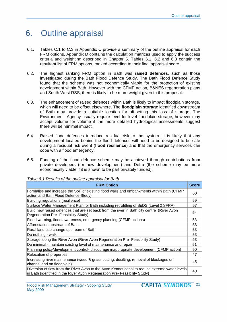
Outline appraisal
6. Outline appraisal
6.1. Tables C.1 to C.3 in Appendix C provide a summary of the outline appraisal for each FRM options. Appendix D contains the calculation matrices used to apply the success criteria and weighting described in Chapter 5. Tables 6.1, 6.2 and 6.3 contain the resultant list of FRM options, ranked according to their final appraisal score.
6.2. The highest ranking FRM option in Bath was raised defences, such as those investigated during the Bath Flood Defence Study. The Bath Flood Defence Study found that the scheme was not economically viable for the protection of existing development within Bath. However with the CFMP action, B&NES regeneration plans and South West RSS, there is likely to be more weight given to this proposal.
6.3. The enhancement of raised defences within Bath is likely to impact floodplain storage, which will need to be offset elsewhere. The floodplain storage identified downstream of Bath may provide a suitable location for off-setting this loss of storage. The Environment Agency usually require level for level floodplain storage, however may accept volume for volume if the more detailed hydrological assessments suggest there will be minimal impact.
6.4. Raised flood defences introduce residual risk to the system. It is likely that any development located behind the flood defences will need to be designed to be safe during a residual risk event (flood resilience) and that the emergency services can cope with a flood emergency.
6.5. Funding of the flood defence scheme may be achieved through contributions from private developers (for new development) and Defra (the scheme may be more economically viable if it is shown to be part privately funded).
Table 6.1 Results of the outline appraisal for Bath FRM Option
Formalise and increase the SoP of existing flood walls and embankments within Bath (CFMP action and Bath Flood Defence Study)
Score
60
Building regulations (resilience) 59 Surface Water Management Plan for Bath including retrofitting of SuDS (Level 2 SFRA) 57 Build new raised defences that are set back from the river in Bath city centre (River Avon Regeneration Pre- Feasibility Study) 54
Flood warning, flood awareness, emergency planning (CFMP actions) 53 Afforestation upstream of Bath 53 Rural land use change upstream of Bath 53 Do nothing - walk 53 Storage along the River Avon (River Avon Regeneration Pre- Feasibility Study) 53 Do minimal - maintain existing level of maintenance and repair 51 Planning policy/development control- discourage inappropriate development (CFMP action) 50 Relocation of properties 47 Increasing river maintenance (weed & grass cutting, desilting, removal of blockages on channel and on floodplain) 45
Diversion of flow from the River Avon to the Avon Kennet canal to reduce extreme water levels in Bath (identified in the River Avon Regeneration Pre- Feasibility Study) 40
Flood Risk Management Strategy - Scoping Study May 2009
21

Outline appraisal
6.6. The highest ranking FRM option in Keynsham was ground raising or raised defences. This option can be implemented and funded through private development. This option is likely to result in loss of floodplain storage, which will need to be offset elsewhere. There is an opportunity to create floodplain storage within the Keynsham Cadbury's site and/or upstream of Keynsham on the River Chew to offset all defence work carried out in Keynsham. The flood storage area proposed downstream of Bath may provide further opportunity for this offset storage. As with the Bath storage option, the Environment Agency may accept volume for volume replacement if the more detailed hydrological assessments suggest there will be minimal impact.
6.7. Raised flood defences introduce residual risk to the system, which would be assessed and managed through site specific flood risk assessments (which proposed flood resilience measures). Raising ground levels would reduce residual risk at the site.
6.8. Funding of the flood defence scheme may be achieved through contributions from private developers (for new development). It is unlikely that Defra funding would be available as this option would only protect new development.
Table 6.2 Results of the outline appraisal for Keynsham FRM Option Score
Build new raised defences or land raising with flood resilience design to protect potential new development sites adjacent to River Chew and River Avon 64
Building regulations (resilience) 63 Planning policy/ development control- discourage inappropriate development (CFMP action) 59 Flood warning, flood awareness, emergency planning (CFMP actions) 57 Afforestation – expanding existing woodland upstream of Keynsham 56 Rural land use change upstream of Keynsham 56 Storage / wetland creation upstream of Keynsham on the River Avon and the River Chew 56 Surface Water Management Plan for Keynsham including retrofitting of SuDS (Level 2 SFRA) 55
Do nothing - walk away 53 Relocation of properties 53 Do minimal - maintain existing level of maintenance and repair 51 Increasing river maintenance (weed & grass cutting, desilting, removal of blockages on the River Chew through Keynsham and River Avon upstream of Keynsham/Saltford. 51
Sluice gate to prevent backing up of the River Avon into the River Chew. Pumping to reduce flood risk on the River Chew when the outfall is locked 51
Diversion of flow from the River Chew to the River Avon downstream of Keynsham 49 Channel modification on the River Avon between the weir and the water treatment works. 40
6.9. The highest ranking FRM option in Midsomer Norton / Radstock was ground raising or raised defences. This option can be implemented alongside the regeneration strategy in Midsomer High Street and along the Wellow Brook, taking advantage of opportunities to create new habitat and landscape value. The option could be funded through private development. Flood resilience measures are likely to be required for sites potentially affected by a residual risk event.
6.10. This option is likely to result in loss of floodplain storage, which will need to be offset elsewhere. There is an opportunity to create one area of floodplain storage to offset the composite loss. As with the other storage options, the Environment Agency may accept volume for volume replacement if the more detailed hydrological assessments
Flood Risk Management Strategy - Scoping Study May 2009
22

Outline appraisal
suggest there will be minimal impact. The detailed design stage should examine the potential impact to the River Avon due to attenuation of flows on this catchment.
Table 6.3 Results of the outline appraisal for Midsomer Norton / Radstock FRM Option Score
Build new raised defences or land raising with flood resilience design to protect potential development in; Midsomer Norton/ Radstock in three locations on the Wellow Brook.
69
Building regulations (resilience) 63 Storage areas /wetlands upstream of Midsomer Norton on the River Somer and the Wellow Brook. Storage areas upstream of Radstock on the Wellow Brook, Kilmersdon Brook, Snails Brook and Clandown stream.
60
Increase the capacity of the existing culvert on the Clandown stream, Radstock. 60 Planning policy/ development control- discourage inappropriate development (CFMP action) 59
Afforestation – expanding existing woodland upstream of Midsomer Norton 56 Rural land use change upstream of Midsomer Norton/ Radstock 56 Surface Water Management Plan for Midsomer Norton/ Radstock including retrofitting of SuDS (Level 2 SFRA) 55
Flood warning, flood awareness, emergency planning (CFMP actions) 55 Relocation of properties 53 Do nothing - walk away 52 Do minimal - maintain existing level of maintenance and repair 51 Increasing river maintenance on the River Somer through Midsomer Norton and Wellow Brook through Radstock 51
Pumping from the Midsomer High Street to River Somer to the Wellow Brook 50 Further channel modification on the watercourses throughout Midsomer / Radstock 48
Flood Risk Management Strategy - Scoping Study May 2009
23

Conclusions and recommendations
7. Conclusions and recommendations
7.1. A significant investment in flood defence studies has already been made. This study has pulled this information together and identified conclusions and recommendations on how to proceed with the main stage of the FRM Strategy. The Scoping Study is a relatively high level assessment and is not detailed for the options identified to be discounted.
7.2. In identifying the potential FRM options and developing success criteria, the following recommendations/observations have been made for the next stage of FRM Strategy development:
1. A Consultation Strategy should be developed at the start of the next stage which includes named individuals and a list of consultation activities/objectives/dates.
2. The FRM Strategy should focus on the 'critical areas' of Bath, Keynsham and Midsomer Norton/Radstock critical areas, cover fluvial flood risk, include options that provide protection for the lifetime of development (100 years) and can be implemented within the plan period (15 years).
3. The development and appraisal of options is an iterative process and as such it is expected that the non-preferred options identified in this study will be reexamined where appropriate in the main stage of the FRM Strategy development.
4. The Draft Bristol CFMP was supplied by the Environment Agency for the purpose of progressing the FRM Strategy. The CFMP is expected to be published in Spring 2009. The published CFMP should be reviewed during the main stage of CFMP development to check to see if the objectives, opportunities, constraints, policies or actions have changed.
5. It is anticipated that the baseline scenario will be described as the 'Do Minimal' (rather than Do Nothing).
6. Further investigation is required in the combination of raised defences (with various standards of protection) alongside other approaches (i.e. flood warning and flood resilience).
7. The success criteria and recommendations included in Chapter 5 give an indication of an approach to the methodology that could be used to select options in the main stage.
8. The weightings assigned to the success criteria were suitable for the purpose of the Scoping Stage but will need to be revisited when the success criteria are changed.
9. The FRM options discussed in Chapter 6 provide an indication of the preferable options on the basis of the information included in the Scoping Study.
7.3. The FRM strategy plan should make recommendations for feeding back into the higher level strategies/plans ( e.g. CHAMPs, SMPs, CFMPs).
Flood Risk Management Strategy - Scoping Study May 2009
24