Embed Size (px)
Citation preview
5
GeoQIssue 2
Scorching the soilHow do wildfires influence soil properties?
“It only takes one match to burn a thousand trees,” the saying goes. Trees may be the obvious casualties of wildfires, but the soil they grow in has just as much significance in the local ecosystem. How is soil modified by a wildfire? Is it baked beyond recognition, or is it fertilized by the flames? These are the questions that have fired the imagination of Dr Cristina Santín (College of Science, Swansea University, Wales) and her colleagues.
“Soil is a non-renewable resource,” explains Santín. “Trees grow back, but a damaged soil takes hundreds or thousands of years to regenerate.” Therefore, understanding how a soil is altered by a wildfire is a key component in environmental management – par-ticularly with currently increasing trends of wildfire occurrence and severity. However, predicting the effect of burning on a given soil is far from straightforward. A number of factors complicate the picture and Santín highlights local climate, vegetation type, slope aspect, and fire intensity as key factors.
Isolating the effect of a wildfire from other environmental variables can therefore be a tricky problem, and this is where Santín steps in. Her research, published in a wildfire-specific edition of Catena, shows differences in soil chemistry between two neighbouring river basins in the Cantabrian Cordillera, a fire-prone region in the north of her home-country of Spain. The proximity of these basins implies that variations of environmental variables would be limited, and only their wildfire history would differ.
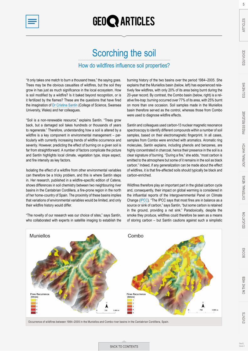
“The novelty of our research was our choice of sites,” says Santín, who collaborated with experts in satellite imaging to establish the
burning history of the two basins over the period 1984–2005. She explains that the Muniellos basin (below, left) has experienced rela-tively few wildfires, with only 20% of its area being burnt during the 20-year record. By contrast, the Combo basin (below, right) is a rel-ative fire-trap: burning occurred over 77% of its area, with 25% burnt on more than one occasion. Soil samples made in the Muniellos basin therefore served as the control, whereas those from Combo were used to diagnose wildfire effects.
Santín and colleagues used carbon-13 nuclear magnetic resonance spectroscopy to identify different compounds within a number of soil samples, based on their electromagnetic fingerprint. In all cases, samples from Combo were enriched with aromatics. Aromatic ring molecules, Santín explains, including phenols and benzenes, are highly concentrated in charcoal, hence their presence in the soil is a clear signature of burning. “During a fire,” she adds, “most carbon is emitted to the atmosphere but some of it remains in the soil as black carbon.” Indeed, if any generalization can be made about the effect of wildfires, it is that fire-affected soils should typically be black and carbon-enriched.
Wildfires therefore play an important part in the global carbon cycle and, consequently, their impact on global warming is considered in the influential reports of the Intergovernmental Panel on Climate Change (IPCC). “The IPCC says that most fires are in balance as a source or sink of carbon,” says Santín, “but some carbon is retained in the ground, providing a net sink.” Paradoxically, despite the smoke they produce, wildfires could therefore be seen as a means of storing carbon – but Santín cautions against such a simplistic
Occurrence of wildfires between 1984–2005 in the Muniellos and Combo river basins in the Cantabrian Cordillera, Spain.

6
GeoQIssue 2
viewpoint. In her experience, the amount of black carbon contained within a burnt soil is somehow less than would be expected.
“Fires are everywhere,” she says. “Black carbon is being produced, but we look into the soil and there’s not enough black carbon there.” So what happens to it? Santín blames erosion. Intense wildfires not only change soil chemistry, they also make it easier to erode by damaging its physical structure. In the Cantabrian Cordillera, this process is particularly evident: soil erosion is exacerbated by steep slopes and high rainfall, and intense wildfires have caused moun-tain peaks, like those below, to be denuded of their soil and vegeta-tion cover.
The fate of eroded black carbon is unclear, and it is not known whether it is mineralized and released to the atmosphere or simply transported elsewhere and buried. The problem for climate predic-tion is that black carbon in the soil behaves completely differently to that in the atmosphere, where it is identified as an agent of global warming. Santín therefore hopes further integrated research will determine the role of black carbon in different components of our climate system and ultimately find out if wildfires really are a car-bon sink.
Recently, Santín has been setting off alarm bells around the Swan-sea campus, conducting controlled burning tests in the University grounds. The team are therefore looking forward to the summer season of research, to be spent in the Northwest Territories of Canada; here, to prevent catastrophic wildfires, land management agencies burn over 12,000 hectares of forest each year, providing the ideal testing environment for black carbon studies.
The spark of wildfire research has certainly taken hold, and dedi-cated sessions were reconvened at the EGU General Assembly in April. There, twelve talks, twenty posters – and the ‘celebrities’ of the wildfire world – focused on the life story of black carbon, from its production through to its decomposition and erosion. The role of wildfires, it would seem, truly is a hot topic.
Adam Booth, post-doc at Imperial College, London
ReferenceSantín, C. et al (2008): Wildfires influence on soil organic matter in an Atlantic mountainous region (NW of Spain), Catena, 74, 286–295.
Mountain peaks in the Cantabrian Cordillera, stripped of their soil cover following erosion after a wildfire. (Credit: C. Santín)
Why virgin forests are not erosion-freeStudy asserts that hydrological characteristics of undisturbed forests,
not vegetation cover, determine land susceptibility to erosion
It is a widely held belief that forest cover controls erosion. Yet, observations worldwide suggest high erosion rates are far from exceptional in undisturbed, or so-called virgin, forests. A recent study advances that incident low erosion rates under forest eco-systems are not associated with the tree cover. Instead, they are related to the oriented course that water follows in the soil, the so-called flow path, in these particular ecosystems. A flow path can be oriented in predominantly vertical or horizontal direction. If lat-eral or horizontally oriented flow paths prevail under virgin forest – not a rare occurrence, – well-developed forest cover is no guar-antee for effective erosion control. These conclusions are impor-tant to identify erosion-prone areas and select appropriate mitiga-tion measures.
After a survey of published research disclosed apparent heteroge-neity of the eroded material under forests, Alexander Zimmermann (Potsdam University, Germany) and his colleagues dug further and found that a selection bias exists for study sites with dominantly
vertical flow paths. This bias may have contributed to the idea that forests are effective at erosion control.
Evidence from Panama
Zimmermann and his team monitored suspended sediment concen-trations in overland and stream flows of a tropical forest in Barro Colorado Island in Panama, undisturbed since 1923. Despite the forest’s relatively high density, and rainfall intensities that rarely exceed the soil infiltration capacity, the site is prone to frequent and widespread discharge that flows overland. In dry and normal years, respectively, between one and two tonnes of eroded material per hectare are observed. The research team identified impermeable soil layers near the soil surface as drivers of the erosion processes. These layers render the soil saturated and impede unrestricted ver-tical flow.

7
GeoQIssue 2
The researchers drew their conclusions based on samples of sus-pended erosion material taken at different sites in the forest. Addi-tionally, they modeled the amount of eroded material that is lost during single high-rainfall events and what is lost over a whole year.
They did not use the traditional graphical methods that relate dis-charge and sediment concentration in a one-to-one correspond-ence. Instead, they applied statistical techniques that, based on a set of twofold rules, divide observations of discharge and other hydrological variables into groups, forming what is called decision trees. Each leaf of these decision trees contains an interval of val-ues that cover new observations. Based on the group to which new observations belong, prediction intervals of erosion material quan-tity are constructed. The techniques are suitable to consider dif-ferent processes that determine the amount of eroded material, including the antecedent wetness of the soil. Further, with these techniques, it is possible to assess the accuracy and precision of the predicted amount of eroded material.
The site at Barro Colorado Island is not an isolated case where the interplay between soil and rainfall characteristics triggers horizontal flow near the forest floor. The findings in Panama add to the wealth of evidence that overland flow may occur frequently in undisturbed forest environments. In these environments, soils with superficial impermeable layers (shallow soils that hold only a limited amount of water), or water-rejecting conditions at the soil surface, contribute to the activation of overland flow. The erosion process starts with the movement of leaf litter and fine soil material that fill the pores of the hill slope soils, which promotes more transport and results in more eroded material. Additionally, major rainfall events can even cause the banks of streams to collapse, which increases the amount of erosion material dramatically.
Comparisons among undisturbed forest sites indicate that hydrolog-ical characteristics strongly influence the quantity of eroded mate-rial in discharge in forested areas. Where horizontal flow paths near
the forest’s soil surface are absent, the annual sum of eroded mate-rial can be very low, while high erosion rates can be found where these horizontal paths dominate.
Nutrient-poor and sparse tree cover is beneficial
Interestingly, the scientists hypothesize that nutrient-poor or sparsely covered forests may be more effective in erosion con-trol. In strongly nutrient-limited ecosystems, leaf litter of low quality decomposes slowly and accumulates on the forest soil. In combina-tion with thick networks of fine roots in the soil, this may reduce the kinetic energy of precipitation that reaches the ground through the forest cover and slow down erosion processes. Counterintuitively, sparse forest covers may have a beneficial influence as well. In this case, better light conditions allow growth of shrubs and herbs on the forest floor, which are effective in preventing sediment transport.
Without doubt, vegetation can reduce erosion risk compared to bare soil. Yet, forests are not necessarily a guarantee for complete control of erosion. The conclusions of this study are important to identify erosion hot-spots, in particular at sites where high erosion rates are not expected. Undisturbed forest ecosystems character-ized by the horizontal flow paths near the soil surface, relatively nutrient rich soils, and a low light availability at the forest soil, are especially vulnerable. It is clear now that, for erosion control, we should also watch our virgin forests carefully.
Eline Vanuytrecht, freelance science writer and PhD student in soil and water management, KU Leuven
ReferenceZimmermann, A.et al. (2012): Forests and erosion: Insights from a study of suspended-sediment dynamics in an overland flow-prone rainforest catchment, Journal of Hydrology 428–429, 170181.
Ink-redible insightSouthern Ocean octopus DNA exposes Antarctica’s mercurial climatic history
Molecular ecologists have traditionally used genetics to better understand the evolution, ecology, and behaviour of life on Earth. But DNA can also be used to gain an historical understanding of the Earth itself, to unlock mysteries of the planet’s past, and to support predictions about its future. By comparing genetic patterns found within populations of living organisms, researchers can look back in evolutionary time to esti-mate when each population may have split off as a result of chang-ing climatic or geographical features. In an compelling study published recently in Molecular Ecology, researchers show how DNA from a species of Antarctic octopus can
be used to support and interpret hypothesized past climate events – in this case, the collapse of the West Antarctic Ice Sheet during the Pleistocene interglacial periods roughly 1.25 million years ago.
Reconstructing the past with present-day implications
In a broader sense, these findings are important because they demonstrate how geoscientists can apply biological data to expose the history of the abiotic, or non-living, environment. More specifi-cally, however, these results provide a rare glimpse into the climatic

8
GeoQIssue 2
history of Antarctica during relatively recent geologic times. They support existing climatic reconstructions, showing that the West Antarctic Ice Sheet, one of the planet’s largest ice bodies, may on several occasions have collapsed and melted as a result of warm-ing temperatures.
These historic melting events would likely have had far-reaching consequences on local and global biogeography. Sea levels would have risen, connecting seas on opposite ends of the Antarctic con-tinent. Today, such sea-level rise would be catastrophic to human coastal communities, emphasising the need for scientists to con-tinue to raise awareness about the impact of climate change on Antarctica.
The interdisciplinary nature of this study, merging genetics with the geosciences, was a main driver in its conception. “We wanted to investigate whether there was any genetic information that could tell us what the past environment could have been like,” notes Louise Allcock of the National University of Ireland in Galway to Scientific American.
Octopod as an ideal model
The study, carried out by an international group of scientists, exam-ined genetic patterns in Turquet’s octopus (Pareledone turqueti), a relatively small polar octopod found on the floor of the Southern Ocean at depths of up to 1,000m. Despite its circumpolar distribu-tion, living around the entire Antarctic continent, this species has a characteristically small home range and low level of dispersal. Such life history traits are vital for this study because they ensure that populations sampled at different localities have mostly lived in physical, and thus genetic, isolation from each other. “This octopus species, with its large population around the region and limited movements, was an ideal species to use,” reflects Allcock.
In addition, octopods are an appropriate model organism for this study because their genetic makeup is well known and enables the use of a molecular clock, a technique by which mutations in genes and the resulting evolution of new species can be chronologically placed in the context of Earth’s history.
Finally, environmental factors further prevent Turquet’s octopus populations from mixing, including powerful circular currents, or gyres, that prevail in the Weddell and Ross seas and keep most smaller organisms from leaving the area.
Genetically similar separate populations
Despite the significant genetic differentiation found between most pockets of Turquet’s octopus populations, individuals sampled specifically at the Weddell and Ross seas, some 10,000km apart and on opposite sides of Antarctica, are remarkably similar on the genetic level. This suggests that, at some point in the past, the two seas were connected at what is now the West Antarctic Ice Sheet. “These two seas are completely separate so we expected the genet-ics of these octopuses to be quite different. Ocean currents both facilitate and hinder the flow of genes. But the Antarctic Circumpolar Current almost certainly would not have facilitated so much disper-sal by octopuses that the two populations would have almost identi-cal genetics if the ice sheet had been in place,” explains the study’s first author, Jan Strugnell of La Trobe University, Australia. This point was reiterated by Phil Watts of the University of Liverpool, UK, also an author on the paper. In a press release, he explains, “We found that they [the different octopus populations] were geneti-cally similar, suggesting that at some point in their past these popu-lations would have been in contact with each other, perhaps at a time when the oceans were connected by, not separated from, the West Antarctic Ice Sheet.”
Turquet’s octopus (Pareledone turqueti) is a relatively small benthic octopus. An enigmatic homebody, its DNA may harbour untold stories about the climatic history of Antarctica. (Source: Wikimedia.)
The West Antarctic Ice Sheet has collapsed on several occasions in history, raising sea levels and allowing life to move between the Weddell and Ross seas. (Source: Image modified from Wikimedia.)

9
GeoQIssue 2
Interview with Millie Basava-Reddi of the IEA Greenhouse Gas R&D Programme at EGU 2012
Basava-Reddi talks about her work on evaluating technologies that can reduce greenhouse gas emissions, in particular carbon capture and storage.
Could you introduce IEAGHG, the International Energy Agency Greenhouse Gas research and development programme and tell us a bit more about it?
The programme is implementing an agreement set up by the IEA in 1991, with the aim of evaluating technologies which can be used to mitigate greenhouse gases. Most of what we’re looking into at the moment is carbon capture and storage (CCS). Programme staff, along with our members and research networks, try to identify existing knowledge gaps and we commission contractors to carry out studies in these areas. All of the studies are then reviewed by external experts. Our aim is to produce non-biased and trustworthy information.
What sort of studies have you conducted recently?
The most recent study I was looking after was one on the feasibility of monitoring CO2 storage underground. When CO2 is injected into the ground, the pH will increase due to the increased partial pres-sure of CO2 and it’s likely to react with the rocks and minerals in situ. A range of cations and anions will be produced and it’s important to be able to monitor these substances. You also need to be able to monitor brine that is displaced from storage sites in order to comply with regulations. Our study was concerned with these substances that are mobilized by injection of CO2.
The genetic survey also provided novel biological information about the dynamics of Turquet’s octopus populations in the Southern Ocean. For example, the data show that populations spiked in 1829 and 1902 near South Georgia and that the species managed to sur-vive glacial maximum periods in these and other areas, when ice sheets were at their maximum extension and water bodies were locked away under thick layers of ice. The last of these periods occurred between 26,500–20,000 years ago.
Unprecedented sampling scale
The team used samples previously gathered by the International Polar Year and Census of Antarctic Marine Life efforts, fish surveys, and by the Alfred Wegener Institute, which allowed them to examine the genetic data on an unprecedented scale. They obtained gene sequences from over 450 Turquet’s octopus individuals taken, by trawling the sea floor with a net, from locations all around the Ant-arctic continent.
“We were able to take advantage of much larger sample sizes than had been collected from Antarctica before. This presented us with a unique opportunity,” said Allcock to Planet Earth Online.
Taken together, these results provide an interdisciplinary perspec-tive on Earth’s past climate, and the life cycle of an enigmatic octo-pod species, while also demonstrating the important potential role of modern molecular methods in unlocking the mysteries of our planet’s geologic history.
Edvard Glücksman, EGU Science Communications Fellow
ReferencesStrugnell, J. M. et al. (2012): Persistent genetic signatures of historic climatic events in an Antarctic octopus, Molecular Ecology, 21 (11), 2775–2787
Millie Basava-Reddi after her interview at this year’s General Assembly. (Credit: Tim Middleton)

10
GeoQIssue 2
Does the IEA programme do any research on the total global capacity available for CO2 storage?
We like to keep up to date with everything going on and we’ve had a few studies looking at capacity. An interesting study a few years ago looked at efficiency factors. The study found that about 2% of the available storage space in deep saline aquifers is actually usable. Other studies since have found even lower numbers.
We’re also planning a future study looking at the differences between static and dynamic capacity. Static capacity simply looks at how much of the available storage space can be used, whereas dynamic capacity considers the injection scenario, where the wells are, how far apart they are, and the length of time injection will be occurring for.
Do your research programmes consider the safety of CCS and how this is communicated to the general public?
We run a set of research networks that have meetings once a year. One of these is a social research network which looks into the public perception of CCS. The IEA itself doesn’t do any work directly with the public though.
It has been suggested that we need 3,500 projects the size of the Sleipner CCS scheme in Norway in order to make a significant contribution to GHG mitigation. But the number of projects likely to be in operation over the next few decades is much less than this. Are we ever going to be able to achieve these ambitious targets?
The IEA CCS Technology Roadmap suggests that we need 100 CCS projects by 2020. We commissioned a study which found that a G8 target of 20 CCS projects by 2020 is achievable with the right investment inputs but that the IEA target is not really possible! How-ever, the target of 100 projects might be realized by 2028. What
this is all dependent on, though, is the actual capacity that will be available because there’s so much uncertainty related to this at the moment. In the North Sea, we’re likely to use depleted gas fields to begin with where you have more of an idea about how much you’re going to be able to store, whereas with deep saline aquifers there’s the potential for high capacities, but with a lot of uncertainty. The main area for further research, therefore, is improvement of capac-ity estimates.
Most current CCS projects are pilot schemes or demonstration projects. How do we go about implementing more large-scale projects?
There are a few larger-scale projects in the pipeline, such as the Gorgon Project in Australia which is due to come online in 2014. The UK competition (which includes one billion pounds of capital funding) is also looking at the potential for larger projects. We really need these larger projects to come online so that we can learn from them.
So is the major barrier to progress a scientific one or a political one?
The majority of projects that have been cancelled or put on hold have been for political or economic reasons, but that’s not to say that there aren’t technical issues. The ZeroGen project in Aus-tralia, for example, was cancelled for technical reasons because there wasn’t adequate storage space. But for a project to get going, it does have have a fair amount of government subsidy because they’re not cheap, especially the first project of a certain kind.
Interview conducted by Tim Middleton (University of Cambridge) at the 2012 EGU General Assembly
GE LOGthe official blog
http://egugeolog.wordpress.com


![The Scorching Star [English]](https://img.pdfslide.net/doc/110x75/577cde171a28ab9e78ae5d54/the-scorching-star-english.jpg)