Embed Size (px)
Citation preview
RC Biological Consulting, Inc. 1 T&R Mini-Storage MUP 05-052
RC BIOLOGICAL CONSULTING, Inc. 12737 Campo Road, Spring Valley, CA 91978
phone: (619) 463-1072 fax: (619) 463-0859 email: [email protected]
_______________________________________________________ March 23, 2013 County of San Diego Department of Planning and Land Use 5201 Ruffin Road, Suite B San Diego, CA 92123 Deer Springs Fire Protection District 8709 Circle R Drive Escondido, CA 92026 SUBJECT: FIRE PROTECTION PLAN – LETTER REPORT T&R Mini-Storage Major Use Permit: 3300 05-052 Assessor Parcel Numbers: 187-170-48-00, 187-170-49-00 and 187-100-36-00 This Fire Protection Plan (FPP) – Letter Report is submitted pursuant to the County Fire Code and the County Consolidated Fire Code, to address the adverse environmental effects that a proposed project may have from a wildland fire and to provide mitigation of those impacts to ensure that the project does not expose people or structures to a significant risk of loss, injury or death involving wildland fires. This project and letter have been revised in response to comments from the County of San Diego dated March 4, 2013. PROJECT DESCRIPTION T & R Mini Storage (the project) proposes 5 acres of Residential Industrial use near the intersection of Centre City Parkway and Ivy Dell Lane in the unincorporated community of Hidden Meadows in northern San Diego County. The 5 acre parcel will have a density of 5 mini-warehouse units totaling 121,793 square feet with an onsite office building that will operate between the hours of 8 am to 6 pm. The project will take access onto Center City Parkway, an existing public road located to the east. With the exception of the office portion, approximately 2,200 square feet, immediately adjacent to Centre City Parkway, the structures are non-habitable.
SDC PDS RCVD 06-20-13 MUP05-052
RC Biological Consulting, Inc. 2 T&R Mini-Storage MUP 05-052
ENVIRONMENTAL SETTING 1. Location: The project is located near the intersection of Centre City Parkway and Ivy Dell Lane in the unincorporated community of Hidden Meadows in northern San Diego County. The surrounding land use includes undeveloped lands, a trailer park and rural residential. 2. Topography: The site consists of an elevation ranging from approximately 875 feet above mean sea level (AMSL) along the eastern boundary to approximately 920 feet AMSL along the western property line. The proposed project area is generally a gentle easterly slope. The area to the west of the proposed project is composed of steep slopes abutting Interstate 15. 3. Geology: No geological constraints exist to pad design or access. The proposed project is located at the base of the slope decreasing its risk in a wildfire compared to if it were located at the top of the slope. 4. Flammable Vegetation: The project site is generally composed of coastal sage scrub and chaparral. The entirety of the site will be developed and all native vegetation removed. Offsite vegetation consists of essentially the same vegetation that is currently present onsite. 5. Climate: The project is located within the transitional climate zone with an average rainfall of 18 inches per year. The site is subject to Santa Ana wind events. PROJECT EXPOSURE TO WILDLAND FIRES 1. Water Supply: Water will be provided by the Water District. The water main capacity shall be determined by the size and type of construction of the largest building. The largest proposed building is approximately 76,080 square feet. Assuming the building is Type IIIB construction per Appendix B of the California Fire Code, the required fire flow would be 5, 750 gallons per minute. All of the buildings shall have fire sprinklers allowing for a reduction of 50% in the fire flow requirements. The minimum fire flow capacity shall be 2,875 gallons per minute. Hydrants shall be located along fire access roadways as determined by the Fire Marshal to meet operational needs, at intersections, at cul-de-sacs, and at intervals pursuant to the County and Consolidated Fire Code. 2. Fire Access: Location. The primary access is by private driveway from Centre City Parkway, directly across from the intersection with Ivy Dell Lane. Centre City Parkway is a public road with evacuation access in both the northerly and the southerly directions.
RC Biological Consulting, Inc. 3 T&R Mini-Storage MUP 05-052
Width. All onsite access roadways are in a minimum of 24 feet in width with all-weather surface suitable for travel 75,000 lb. fire apparatus. Vertical Clearance. Minimum vertical clearance of 13 feet 6 inches myst be maintained for the entire required width of the fire access roads. Grade: The maximum grade proposed byt eh project is 12%. Grades greater than 15% are not permitted without mitigation; grades greater than 20% are prohibited. Surface: The project access roads will be surfaced with a minimum of 2” of asphaltic concrete over approved base. 3. Setbacks from Property Lines: The project is in a high hazard area, as a result the minimum setback from property lines abutting national forests, open space preserves and designated riparian areas is 100 feet. 4. Building Construction: The construction methods for exterior wildfire exposure in an wildland-urban interface fire area shall be as provided in Chapter 7A of the County Building Code. The project proposes the following:
• Slab on grade foundations • First floor walls are Concrete Masonry Units with stucco over. • Internal demising walls are steel • 2nd floor of Building C is a composite metal deck with concrete over. • 2nd floor exterior wall of Building C will be steel with stucco over. • Roofs – standing seam metal roofs at storage areas. Two piece clay tile at the
front of Building A and B. 5. Fire Protection Systems: Per County Consolidated Code approved automatic fire sprinkler systems shall be installed in all new structures. For the purpose of fire sprinkler systems, building separated by less than 10 feet from adjacent buildings shall be considered one building. Fire barriers and partitions, regardless of rating, shall not be considered as creating separate buildings for the purposes of determining fire sprinkler requirements. Mezzanines shall be included in the total square footage calculations. 6. Defensible Space: Fuel modification setback shall be 70 feet portions of Building D and E and 100 feet for all other buildings. The reduction from 100 feet to 70 feet for buildings D and E is a result of site constraints including biological resources, topography, and aesthetics. Justification to allow the reduction includes several factors that are incorporated into the project design:
• The buildings shall be constructed of non-combustible materials. • The buildings are non-habitable. • The buildings shall not have openings along the side adjacent to the reduced fuel
modification zone.
RC Biological Consulting, Inc. 4 T&R Mini-Storage MUP 05-052
• Building D is partially below grade (built into the hillside) and located down slope from the native vegetation reducing its exposure to wildfire.
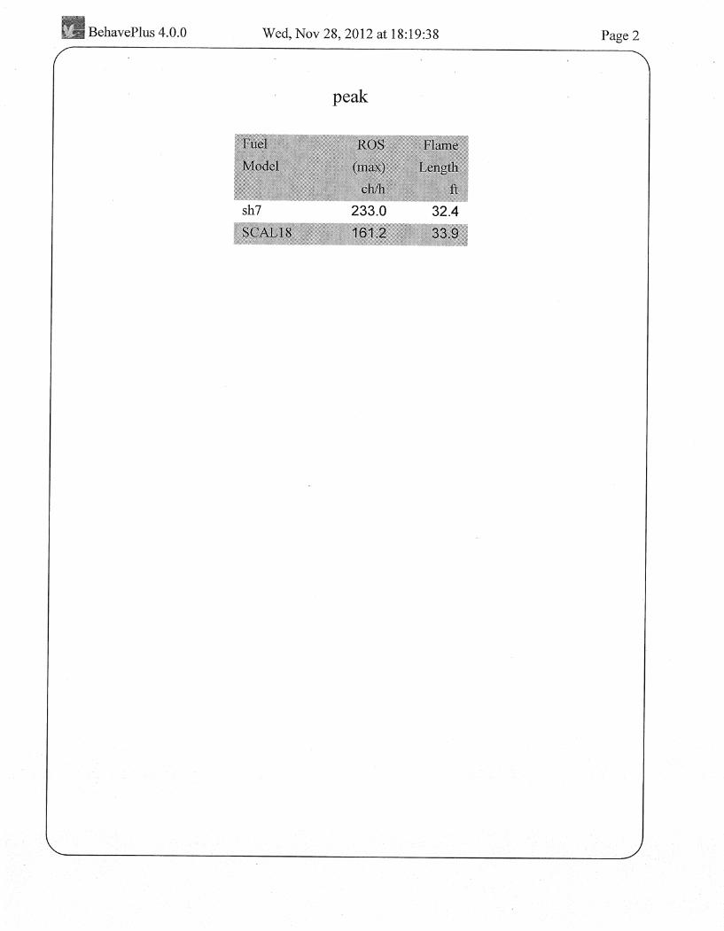
• The project will be served from municipal water supplies. Additionally, as summarized within the Fuel Modeling attachment the greatest anticipated flame length is from the vegetation burning during a Peak Santa Ana fire. The resulting flame length is 33.9 feet. The remaining flame lengths are less than 33.9 feet. A fuel modification zone of 70 feet proved two times the anticipated flame length. 7. Vegetation Management: Prescribed Defensible Space (fuel management zones) will be maintained by the property owners at least annually or more often as needed. Boundaries of fuel management zones will be clearly and permanently marked. Plants used in the Defensible Space will be from an approve fire resistant planting materials list that is maintained by the County of San Diego, Department of Planning and Land Use. 8. Fire Behavior Computer Modeling: Fire behavior modeling has been performed and is included as an attachment.
3/23/2013 Robin Church Principal Prepared By (Signature) Date Printed Name Title _____________________________________________________________________ Property Owner (Signature) Date Printed Name

RC Biological Consulting, Inc. 1 T&R Mini-Storage MUP 05-052 Fuel Modeling November 2012
RC BIOLOGICAL CONSULTING, Inc. 12737 Campo Road, Spring Valley, CA 91978
phone: (619) 463-1072 fax: (619) 463-0859 email: [email protected]
November 28, 2012 County of San Diego Department of Planning and Land Use 5201 Ruffin Road, Suite B San Diego, CA 92123 Deer Springs Fire Protection District 8709 Circle R Drive Escondido, CA 92026 SUBJECT: FUEL MODELING FOR T&R MINI-STORAGE Major Use Permit: 3300 05-052 Assessor Parcel Numbers e.g. 187-170-48-00, 187-170 -49-00 and 187-100-36-00 The following letter provides the results of the fuel modeling performed for this project as a supplement to the Fire Protection Plan (FPP) – Letter Report previously submitted to the County of San Diego and Deer Springs Fire Protection District. Please refer to the Fire Protection Plan Letter Report for project description and location information. Environmental Setting Topography and Climate The project site was visited on March 21, 2012 to review the topography, vegetation and existing uses of the property. The site consists of an elevation ranging from approximately 875 feet above mean sea level (AMSL) along the eastern boundary to approximately 920 feet AMSL along the western property line. The proposed project area is generally a gentle easterly slope. The area to the west of the proposed project is composed of steep slopes abutting Interstate 15. The topography of the area has a mixture of moderate, to steep terrain along with gentle slopes. Generally speaking the project is located at the base of the hills to the north, west and south.
RC Biological Consulting, Inc. 2 T&R Mini-Storage MUP 05-052 Fuel Modeling November 2012
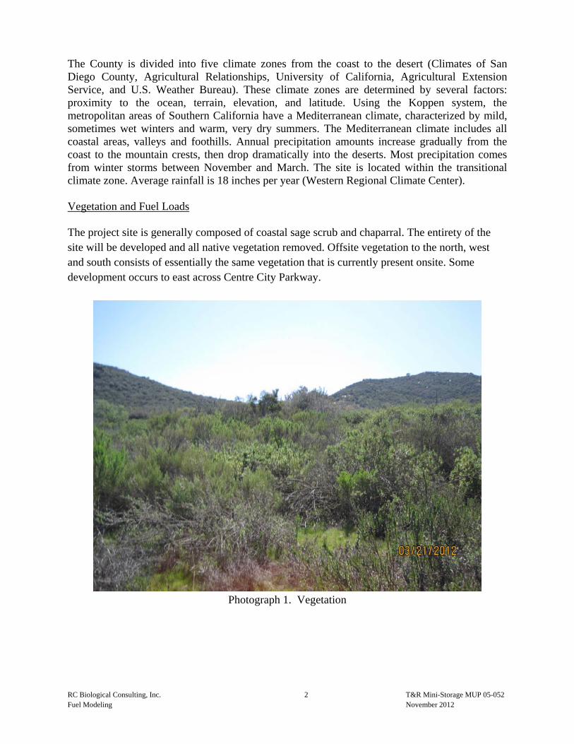
The County is divided into five climate zones from the coast to the desert (Climates of San Diego County, Agricultural Relationships, University of California, Agricultural Extension Service, and U.S. Weather Bureau). These climate zones are determined by several factors: proximity to the ocean, terrain, elevation, and latitude. Using the Koppen system, the metropolitan areas of Southern California have a Mediterranean climate, characterized by mild, sometimes wet winters and warm, very dry summers. The Mediterranean climate includes all coastal areas, valleys and foothills. Annual precipitation amounts increase gradually from the coast to the mountain crests, then drop dramatically into the deserts. Most precipitation comes from winter storms between November and March. The site is located within the transitional climate zone. Average rainfall is 18 inches per year (Western Regional Climate Center). Vegetation and Fuel Loads The project site is generally composed of coastal sage scrub and chaparral. The entirety of the site will be developed and all native vegetation removed. Offsite vegetation to the north, west and south consists of essentially the same vegetation that is currently present onsite. Some development occurs to east across Centre City Parkway.
Photograph 1. Vegetation
RC Biological Consulting, Inc. 3 T&R Mini-Storage MUP 05-052 Fuel Modeling November 2012
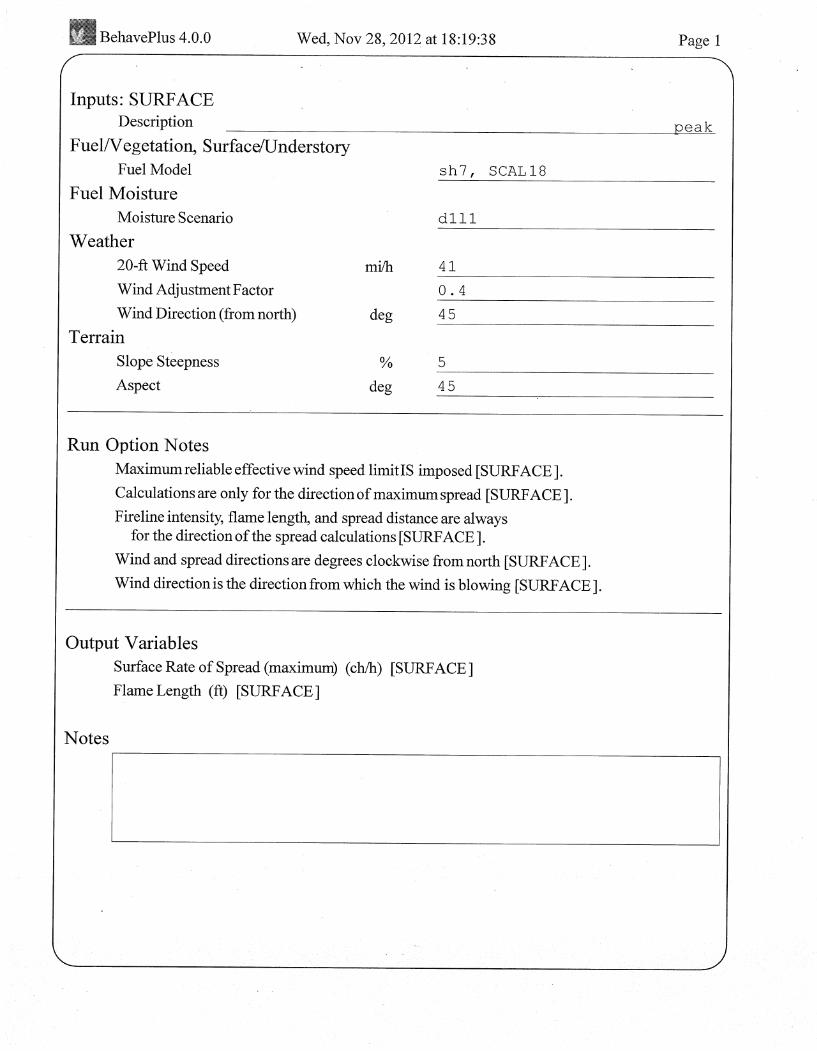
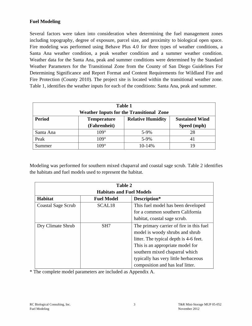
Fuel Modeling Several factors were taken into consideration when determining the fuel management zones including topography, degree of exposure, parcel size, and proximity to biological open space. Fire modeling was performed using Behave Plus 4.0 for three types of weather conditions, a Santa Ana weather condition, a peak weather condition and a summer weather condition. Weather data for the Santa Ana, peak and summer conditions were determined by the Standard Weather Parameters for the Transitional Zone from the County of San Diego Guidelines For Determining Significance and Report Format and Content Requirements for Wildland Fire and Fire Protection (County 2010). The project site is located within the transitional weather zone. Table 1, identifies the weather inputs for each of the conditions: Santa Ana, peak and summer.
Table 1 Weather Inputs for the Transitional Zone
Period Temperature (Fahrenheit)
Relative Humidity Sustained Wind Speed (mph)
Santa Ana 109° 5-9% 28 Peak 109° 5-9% 41 Summer 109° 10-14% 19
Modeling was performed for southern mixed chaparral and coastal sage scrub. Table 2 identifies the habitats and fuel models used to represent the habitat.
Table 2 Habitats and Fuel Models
Habitat Fuel Model Description* Coastal Sage Scrub
SCAL18 This fuel model has been developed for a common southern California habitat, coastal sage scrub.
Dry Climate Shrub SH7 The primary carrier of fire in this fuel model is woody shrubs and shrub litter. The typical depth is 4-6 feet. This is an appropriate model for southern mixed chaparral which typically has very little herbaceous composition and has leaf litter.
* The complete model parameters are included as Appendix A.

RC Biological Consulting, Inc. 4 T&R Mini-Storage MUP 05-052 Fuel Modeling November 2012
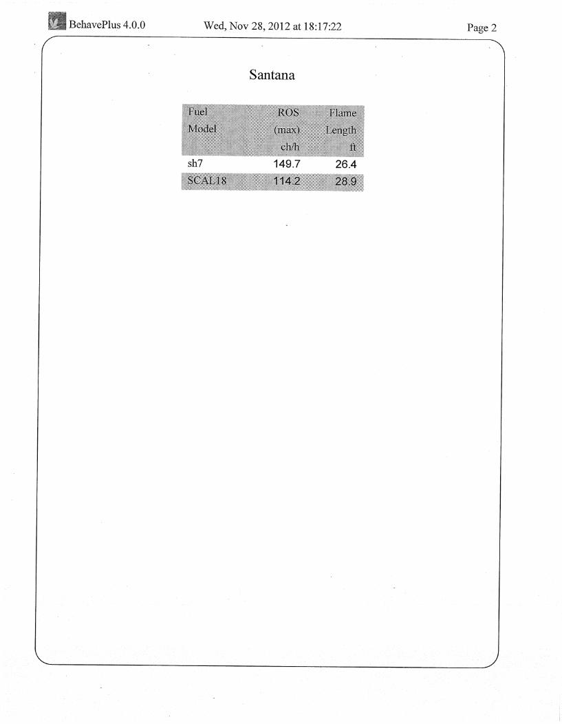
Results The full results of the modeling are included in Appendix B and summarized below for each weather period. Santa Ana Condition A Santa Ana weather condition is potentially the worst weather for fire. Santa Ana’s typically occur from September to May. The fall Santa Ana can create extremely dangerous fire conditions because they are associated with high temperatures, high winds coming from the north/northeast and low humidity. They also occur after long periods of no rain when the vegetation is in a drought stress condition. The soft shrubs that compose habitats such as coastal sage scrub are semi-drought deciduous and have typically lost the majority of their foliage by the end of summer. Modeling was performed using the Santa Ana weather conditions identified in Table 1 and the fuel model identified in Table 2. The model results are presented in Table 3.
Table 3
Results for a Santa Ana Fire Southern
Mixed Chaparral
Coastal Sage Scrub
Flame Length 26.4’ 28.9” Rate of Spread 149.7 ch/h 114.2 ch/h
Peak Conditions Peak conditions are the extreme conditions during a Santa Ana event. The peak winds represent the gusts that occur during a Santa Ana. Modeling was performed using the peak weather conditions identified in Table 1 and the fuel model identified in Table 2. The model results are presented in Table 4.
Table 4 Results for Peak Conditions Southern
Mixed Chaparral
Coastal Sage Scrub
Flame Length 32.4’ 33.9’ Rate of Spread 233 ch/h 161.2 ch/h

RC Biological Consulting, Inc. 5 T&R Mini-Storage MUP 05-052 Fuel Modeling November 2012
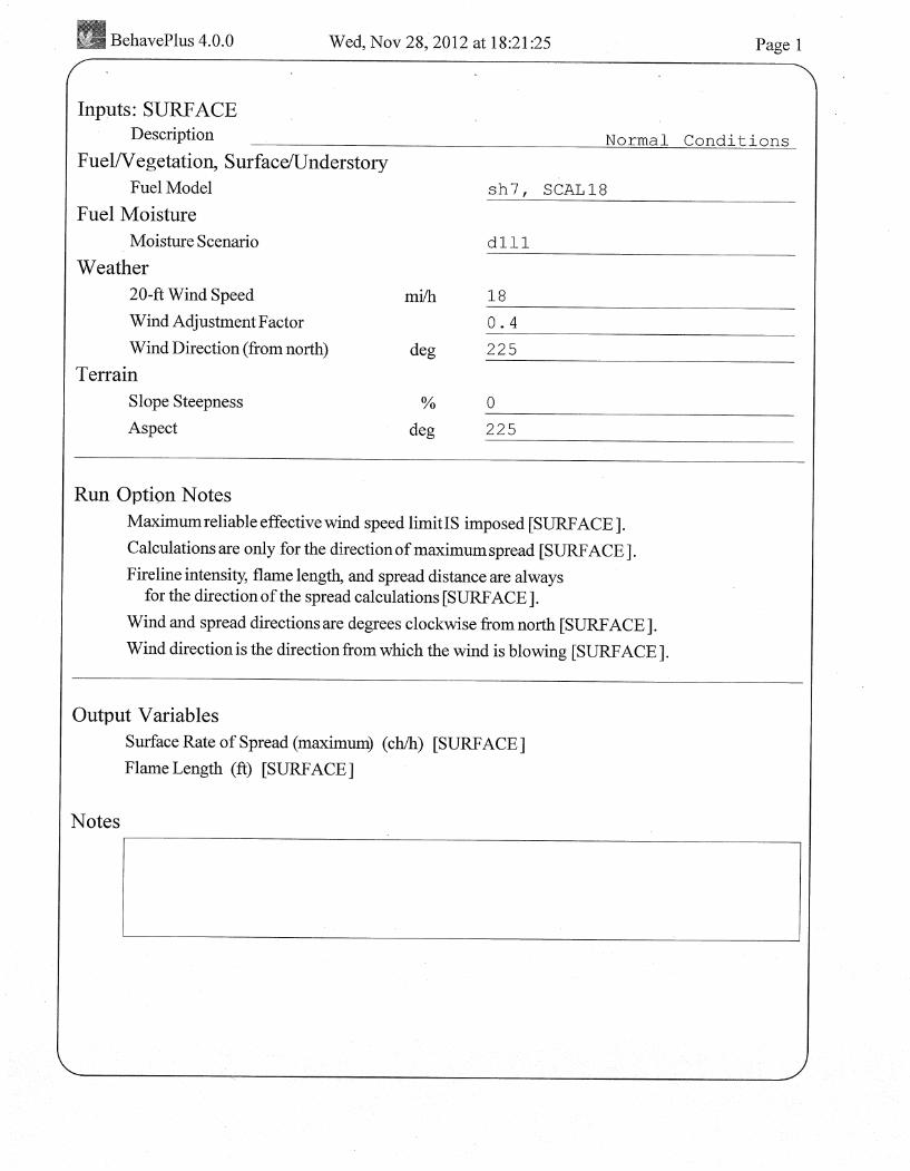
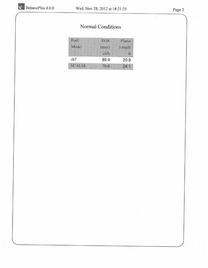
Normal Weather Condition Normal weather conditions consist of an onshore flow from the southwest. This condition has a lower temperature and higher humidity than does a Santa Ana condition. Modeling was performed using the summer weather conditions identified in Table 1 and the fuel model identified in Table 2. The model are presented in Table 5.
Table 5 Results for Summer Conditions
Southern Mixed
Chaparral
Coastal Sage Scrub
Flame Length 20.9’ 24.1’ Rate of Spread 89.9 ch/h 76.6 ch/h
As can be seen from the modeling, the greatest anticipated flame length is from the vegetation burning during a Peak Santa Ana fire. The resulting flame length is 33.9 feet. The remaining flame lengths are less than 33.9 feet. The model is an estimate of the flame lengths that can be anticipated. Actual fire behavior can be more or less intensive. PREPARERS’ LIABILITY STATEMENT RC Biological Consulting, Inc. disclaims liability for any personal injury, property or other damages of any nature whatsoever, whether special, indirect, consequential or compensatory, directly or indirectly resulting from the publication, use of, or reliance on this document by the developer or any regulatory or permitting agency. If you have any questions please do not hesitate to call. Sincerely,
__ _ Robin Church, Principal

APPENDIX A
FUEL PARAMETERS
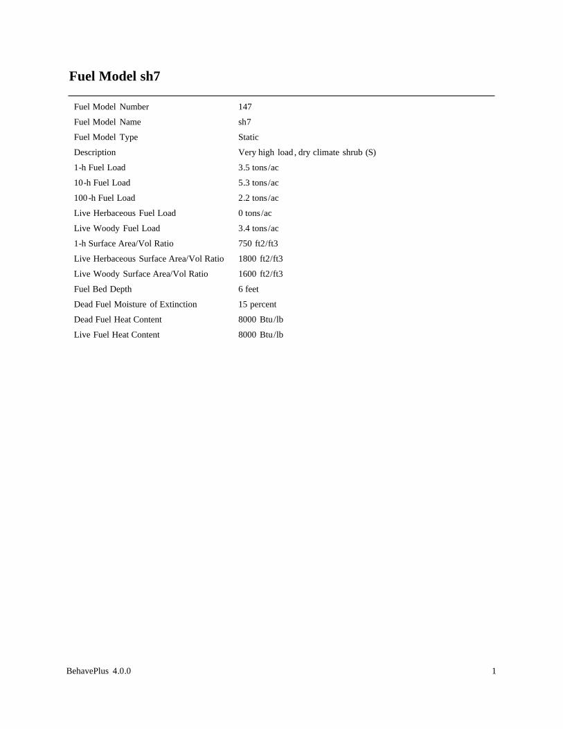
Fuel Model sh7
Fuel Model Number 147
Fuel Model Name sh7
Fuel Model Type Static
Description Very high load , dry climate shrub (S)
1-h Fuel Load 3.5 tons/ac
10-h Fuel Load 5.3 tons/ac
100-h Fuel Load 2.2 tons/ac
Live Herbaceous Fuel Load 0 tons/ac
Live Woody Fuel Load 3.4 tons/ac
1-h Surface Area/Vol Ratio 750 ft2/ft3
Live Herbaceous Surface Area/Vol Ratio 1800 ft2/ft3
Live Woody Surface Area/Vol Ratio 1600 ft2/ft3
Fuel Bed Depth 6 feet
Dead Fuel Moisture of Extinction 15 percent
Dead Fuel Heat Content 8000 Btu/lb
Live Fuel Heat Content 8000 Btu/lb
1BehavePlus 4.0.0

1BehavePlus 4.0.0
APPENDIX B
FUEL MODELING RESULTS