Embed Size (px)
Citation preview

SEP I 2 1985
far u*.*n Ot***
.»vw^* M •©8*Jfo
1;. IK
V 1
1 ^
1**1* .^...Cir-C-:v./j J f j t f •
*«f*. ti** ftfe ^m^-mtm^ WON*

e
Swp* r ' i i l * ' "-< f ;. i« ft ,.'
V-.tn,. ^ rv j i
t i l Chmm\I t« ' «r «-•:>! 2V1-.W. » p . t«** f f ind" nitt« copies
th* attached •'•".:'«<: al format is»tv tu4 «.re *o
,". :'"r , c«t«*:fK «on« . f t ***r pu&Uc i n f ormat ion
••' • VJ.'''- * ,, ; #
' ' * •• • Champ i*« b*« vi r i « M , . "••,!*.-« * t i ? i i i « * j . ^ v , . ^ . r „ , * V • '* ; J ' - ; " ^ ' present t i m a a d
fvf t h i s (Man ' f l l . • . l " f r * * t } i V « P ? r e c M t « 4 i f a p v r o w i
a p p r o v e d n l U t w p*.r™,.( hv tha t M « aa
«-» t » , . , t e < * > * p n a n « aura»#r 1.7J1> 654-2552.
YiMirs wery t r u l y ,
CHAMPLtf* PETROLRiJM COMPANY
^T. « . Car ter , I r . JRC/ABS
At t.achQent<»
Mr. David MaLdoojdrt Minnrals Mandg<>ment S*>fyic» Campus Box i ' f l
Corpus C h r i s t i State s 'niversUy Corpus C h r i s t i , TPXHS 7P<»J2

PLAN OF EXPLORATION
BLOCKS A-185, A-191 and A~l<>4
HIGH ISLAND EAST ADDITION
OCS-G 6209, 6211. and 6212
CHAMPLIN PETROLEUM COMPANY
FOUR ALI.KN CENTER
SUITE 1500
HOUSTON, TEXAS 7 7002
AUGUST 27. 1985

TABLE OF CONTENTS
SECTION
Designated Company Contact I
Proposed Type and Sequence of A c t i v i t i e s and Approximate
Locat ions or the Exploratory W e l l s . . I I
S t r u c t u r e H.«p H I
Shallow D r i l l i n g Hazards And
ArcheoloR i ca I As sessment tV
D e s c r i p t i o n of D r i l l i n g Vessel V
L i s t o f D r i l l i n g Mud Addi t ives VI
O i l S p i l l Contingency Plan V l l Pro jec ted A i r Emissions V I I I Onshore Support Rase F a c i l i t y . IX
Guarantee Statement. . . . . . X
NOTE: Enclosed in the Plan of Exploration are CONT IPENTTAL papers. These papers have heen stamped CONF1 DENTIAL and are deleted from the copies heing submitted for Public Information.

SECTION
A


PROPOSED TYPE AND SEQUENCE OF ACTIVITIES
AND APPROXIMATE LOCATIONS OF THE EXPLORATORY WELLS
Champ I i n Petroleum Companv was awarded the High Is land East Add i t ion
Blocks A-1 ft 5, A-193 .in A-194 OCS-0 6209, 6211 and 6212 leases in the OCS
Western Gulf o f Mexico 01] and Gas Lease Of fer ine held in August, 1984.
Seismic work has been performed over the block and r e s u l t s are addresser!
i n the Shallow D r i l l i n g Hazards Assessment section of t h i s Plan.
Fourteen (14) explora tory we l l s are planned to test the geologic features
in the b l o c k s . Proposed surface loca t ions , d r i l l i n g , completion t ime, and
true v e r t i c a l depth (TVDI are as f o l l o w s :
Ori11i ng ami
We 11 No. Proposed Locat ion Completion Time TVD
M. I . BLOCK A-l 1
A 5400' FSL and 1 700' FWL 200 Davs 20,000'
B 5400' FSL and 5700' FWL 200 Davs 20,000'
C 2700* FSL and 2600' FWL 200 Days 20,000'
D 2 7 00* FSL and 6000' FWL 200 Days 20,000'
E 100' FSL and 8000' FWL 200 Davs 20,000'
M. I . BLOCK A-12
F 5 SOO' FSL and 1400' FFL 200 Days 20,000'
G 2400' FSL and 1000' FEL 200 Days 20,000"
II 2800' FSL and 7200' FEL 200 Davs 20,000'
I 1600' FSL •Hid 800' FEL 200 Days 20,000'
J 100* FSL and 2600' FEL 200 Days 20,000'
M, I . BLOCK A-14
K 2600' FNL and 6500' FWL 200 Davs 20,000'
I. 2600' FNL and 2600" FWL 200 Da v s 20,000'
M. 1. BLOCK A- 1 5
M 1000' FNL and 7500' FWL 200 Days 20,000'
N 1500' FNL and 5500' FWL 200 Da y s 20,000'
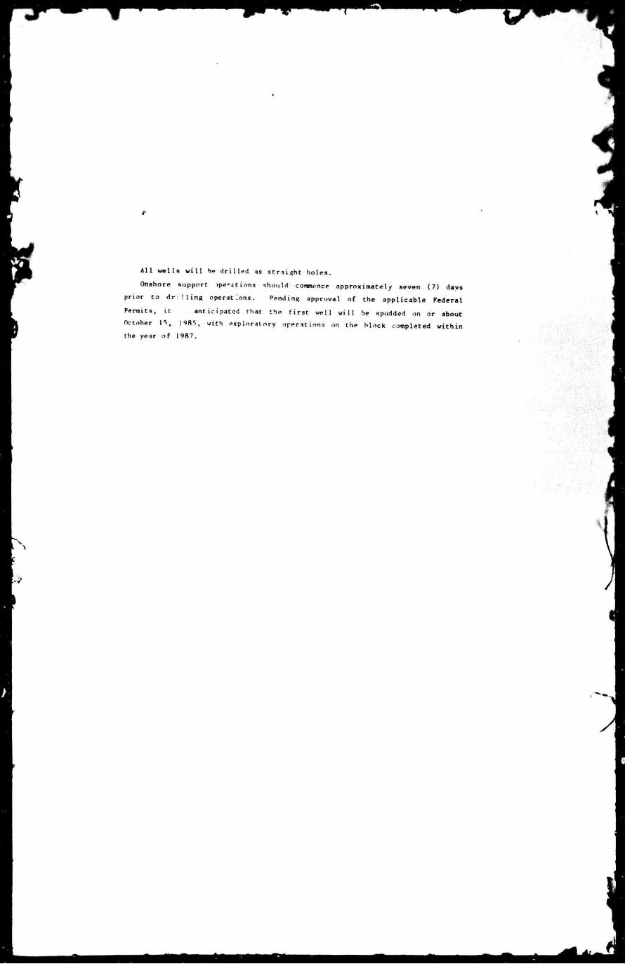
A l l w e l l s w i l l be d r i l l e d as S t ra igh t holes.
Onshore support >pe*«tions should commence approximately seven (7) days
prior to d r i l i n g operations. Pending approval of the app l icab le Federal
Permits, i t ant ic ipated that the f i r s t wel l w i l l be spudded on or about
October \ t >, 198S, with explora tory operations on the block completed w i t h i n
the year o f 1987.

MUSTANG ISLAND AREA
I
/ 7
-r - i
"•Veil
—.
•*' '
V l C i N t T t M A P
1 hereOy certify i*ar tne obc*e •ri foseJ '0C0'iO"i ere correct
fabv/t 0 El iii tf«g \o 4007
•e C. ,v i ••.«.- mt £c-«v t •• • i f f . I i f f I f 1 0 ) ' , ; u ' ' / . » . : / •
Af y, . f • 4 «.a 1 .••) M *i K °t * *• 4 **• >• i: '•<'"
;>,CC?,OM •«• H ' s " 4 ,' '* f t it «.» ' . . 1 B 1 » 15 ii
• : * 4 . • .'»- * /.. • k*l >»," SB 1 ' SBS
6 . .wt'/ 1 •• M J C ' « .• ''• ft Hi • • " • ' i g c « a
> , SvSi , f *"i « 4 ' « : - '•'•»* • • J! > > ? *,•••»,••>; l l «c• ua i
•!•*.»• • » » . * « , ? • • » . '
^ MUX. • ! ' . ».- • 4 1 .>• •• • i i i 4 <
• • • •• :\ *• . J V M i • 4 "» t; l T » i / 0', *) " l •"» 0 * Obt
j ? >.-> • • > 4 1 t •. ! 5 . " » 4 . « • • > i i i s - .
- f 11 %* 6 •. •-' • 4 V / ' * 7 * S i * •>i' i t i » • '•>
• • *0 ' • ' ". it 1 . 4 f ' 4 » • 1 » * " i r
101 » S«. j>. 64 ' P*(J 7 .>. 4 ^ 4 »t* •.» i? k i •. H ;,««>.". * 4 1 H I a :* !.*S f i ' !4 ^6 ."If. H «.. . .% i \ . , 4 4 * 4 H i/V4 ~t • ' W -ft *. ' f
- * , SI , H S H
e H W P LIN PF !ROLEUM
. -> S A M.A I?, A 14, A ; 5
Vu 5 TANG 13 L AN ( t H
OFFSHORE TEXAS
• • •

tf
r
.̂ 1
14;
SECTION l i t
V
I i
A

m I
SECTION
rs
'V

SHALLOW DRTLUNC HAZARDS
VI'STANi'. ISLAND
HLOCKS A-11, A-13, A-l̂ > and A-15
CFFSHr,-" TEXAS
A surv-v ol po t en t i a l L iz i r i s as prepared and in er -. «.• ..-ii by
Hom Of t »*• - • • Survey*, Houston, Texas. The data was ibtain;< w t h a
' :«i i r i • sensor w • ph R»»sol ut i on «ph • «i • i ! survey over 'he »'nt i re tour
block area. The survey inc lude! a Suhbotrow P r o f i l e , .» > •• System,
Side *>can Ron*r, ' ' r ec i s ion Ec*"- •<nder m i a Marine Pro:. Magnetometer.
S -v work commenced >n I ::<•• . • ) , 1985, ind was complete 1 on July h ,
]M Water lepth in rh- hl.-.cks wanes from I 90 feet to 2'V f e e t .
I imp 1 i n ' s ReoloBint lias reviewed f \ " Hazard Survey r e s u l t s ,
'one l us i ons conci ruing i n d i v i d u a l we! i i . . . - ir<' summarised in the
attached l e t t e r and ind i i t - 1 rhat t"-« <<*.>•,• sed wel l s i ' e s iave been
toim.l ncceptaMe,

(
E chomplin
August 20 , 1985
Minerals Management Serv*'-. I b e r i a ' f l f f i c e Bu i ldmq 3301 Nor th "'useway Bo.jl^vard Metar ie , Lou is iana 700' '
RE: H a z a r d C u l t u r a l Survey Mustanq Is 'and Ar^a Blocks A - l 1, A - !? , ft-14, A- ;• O f f sho re . Texas
boot 'emen:
A h iqh r e s o l u t i o n leyphysiea' survey was c o ^ ' j r t e d over the above r a ) * i olocks f o r purposes le^t^mf nf no the safety of d r ' I M n a s ' t - i s an ' .u< resource ovaluat HI.
Analysis of tues* data show no ind icat v. ' of J r i l U n q hazards, sr n w e e ' r . or subme qed pre-, . tor!- : s i t es at th- d r ' H s i t e s 1 i s ted be'ow:
RLOCK A- 1 i ai r)-v BLOO BLOCK A-15 V
»8
• Ml
»:
Dw -on Exp lo ra t i on (ieoo!*ys»cis* Eas*-rn D i v i s i on /O f f sho re
DCR:it*

SECTION V

RESCRIPTTON OF DRILLING RIG
*H. d r i l l i n g r i g Which w i l l h , u ed to d r i l l the we l l s in Mustang
U i , r , . oc.s - 11. A-12, A - U and A-15 w i l l he . i . i l - r to the Western
^ t . u v a modern c a - t i U v e r iacx-up r i g designed f o r 250' water
depths . I t is oq-upp.-.: wi th a l l r e t i r e d safe ty and p o l l u t i , cont • o l
equipment. An equipment l i s t and s p e c i f i c a t i o n .Hetchea are included.
V s s r r r n cneanU, Inc. o f f i c e s are Seated at 515 s. uth Post OaK Road,
Houston, Texas.
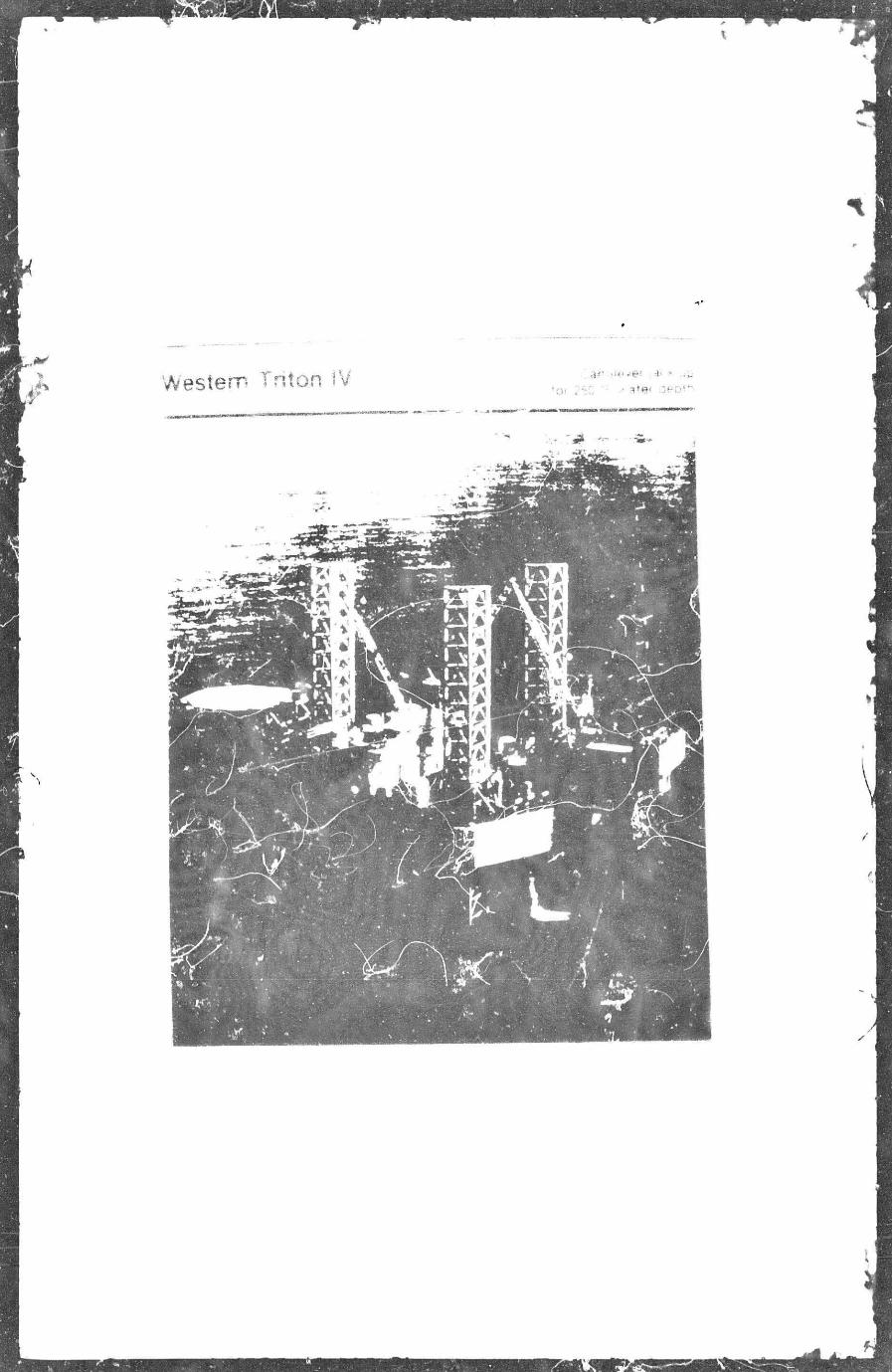


Western Triton IV Cantilever jack-up for 250 ft. water depth
t
- »
!
1
— & -
•f-
^ I ^
- > -
I
— ^ — — fc*— ^ — *o
I i I I i ^ 8* * I i
—#—^—^—*-
— — ^ — — ^ -! ( - J I I
i l l [ ! I _ —^SL_ ^ — ^ — 4* a
-J^—^sjft—jf£—^—jjt— jfi—Jp a s i I i I
_ ^ > — ^ ^ — ^ w
- jr^— 4? 2 1 ! 1
1
- . ^ 5 ^ — > > 4? *
f— J stance Sttw o ' * P(#t 'omi -o t Rotary 4
>»iance * * i a* •
A
<fv«.Qnt 3 ai'Ov*ao<« comOmad - 0 0 * 4 \
A
/
\ 1 j \ v—
weSTCRM TWTON IV
HBBH HRHH PHI

Western Triton IV Cantilever jack-up for 250 ft. water depth
\
24":Jack Ho u i e L
30 A i r Gao *
2c 1' Total
water Cectrt
P e n e f a t i o n *76'
H ' - O " (one bay) recommended safe minimum he igh t ot leg above j ack i ng u n i t .
- r gap is dependent on hur r icane and n o n - h u m care seasor d i noted m Operat ing Manual.

UtournMU componu
marine division vtefcabura mlssbisiool


OU. SPILL CONTINGENCY PLAN
Champ i .n has an approved O i l S p i l l Contingency Plan or ' : le w i t h
th* Miner; Is Management Service in M e r a i r i e , Louisiana. The Plan
ic l.-.des ( I ) not i f i c a t i o n procedures and i 1 i s t ing i f contact agencies
and personnel, (Z) response procedures f.tr s p i l l s of various s izes , (3)
a l i s t i n g of equipment, 1 4.) r e s p o n s i b i l i t i e s of the operator personnel,
(55 t r a i n i n g procedures, and (f>) pre-- n t a t i v e measures to minimize
s p i l l s ar i po l l - i t ion .
Champ I i : : ' s membership in Clean Gulf Associates w i l l make ava i lab le
the Assoc i at t o n ' » o i l s p i l l cleamij. equipment *long 'he Texas and
Louisiana Culf Coast. A f u l l inventory ' f equipment ir . reined at
CCA >iper.it ine basses in Oalvest m and Roc V. port , Texas. «*pei. lent upon
weather condit ions ind 1 -at ion of S » i ? s , t h i s equ ip 1 ' .an be at the
d r i l l s i t e locat ion approximately '•«' ~ . 1 •• s t r <m i tockror t , >xa» w i t h i n 8
hours from the 11 m<> i r a i l is i n i t i a t e d .
Clean Culf Associates has 5 types ot "qmpment < I > fast response
open-sea skimmer. ' high volume vpen—«ea - * immer, (3) shallow water
skinnier, ( 4 ' •• iramuni i t ion . -juipmenr and beach cleanup system, and (5)
boat spray system.
ShouM the i r services be required, Peterson Maritime Services, Inc .
ran provide idd iv iona l men, equipment, >nd mater ia l s to handle bot
m i j o r and mi:: .r •» p i I i * .

Sr - fTI N V I M
I
3̂
J i
4
1
A

PKOJECTEP AIR EMISSIONS
MUSTANG ISLAND BLOCK A-11 , A-12. A-IA and A-15
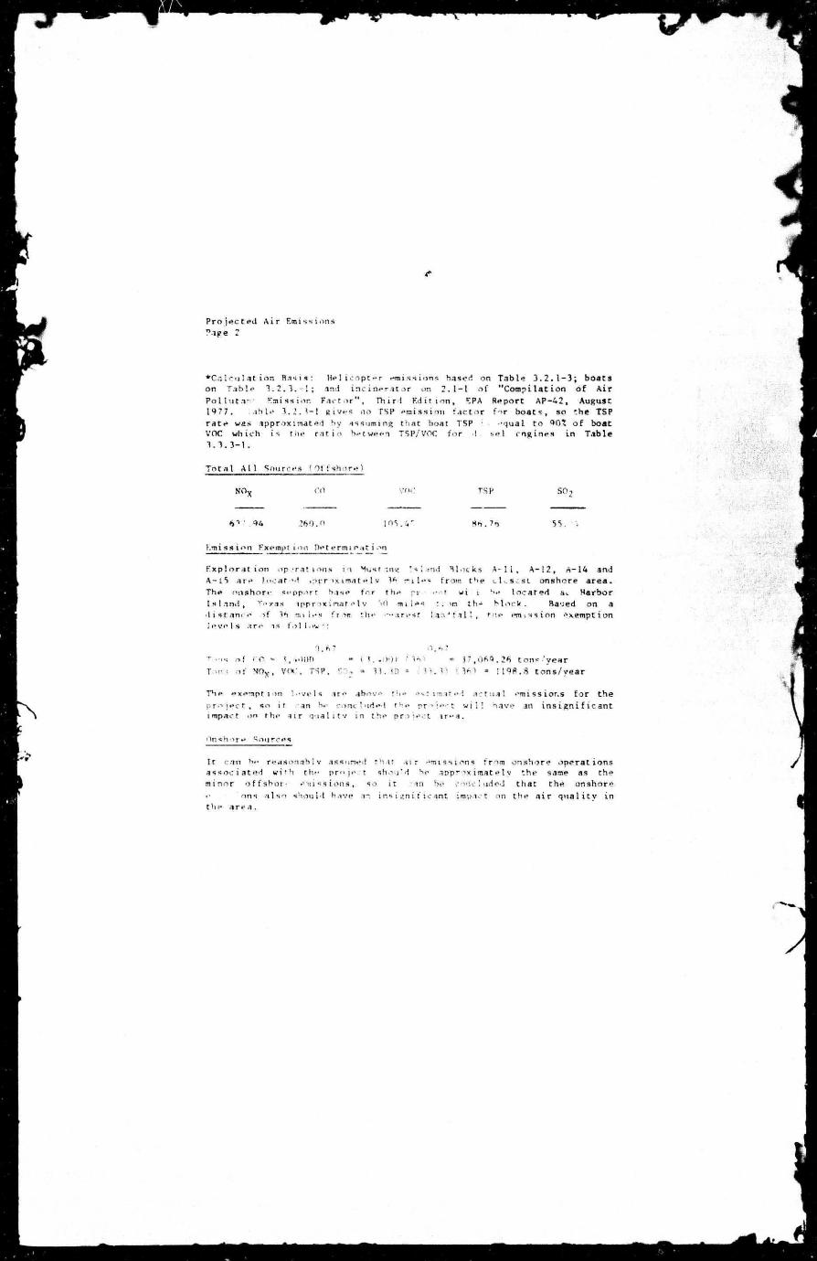
The e x p l o r a t i o n plan for Wustang Island Blocks A - l I , A-12. A-14 and A-15 w i l l consis t of d r i l l i n g , completion and/or abandonment opera t ions . Champlin an t i c ipa t e s the pro jec t w i l t last about 2800 days t o t a l whi le d r i l l i n g four teen (14) *e1U. Each wel l w i l l be d r i l l e d to an average depth of 20,000 feet for 1 t o t a l d r i l l i n g footage of 280,000 f e e t . The projec ted a i r emissions for the projec* are as f o l l o w s :
Major Source - Engines . ' t f s h o r e i
Emissions* Tons per Project
NiK
259.00
CO VOC
if. ?0. 7 2
:sp
!« .508
SO 2
1" 220
*Cale . i la t i - i , s HasU: T o f t horsepower requirement is based on 60 h p h r / f t . from Table k - i , " A t f r i ^ t U m i s s i o n s from Offshore U l and Gas Development m<: P . r«r« i o n " , Ei-A No. ^ W ' - 0 / 6 , J « l * W T , Enri - -miss ion rates are b,*ed m emission f a c e r s >m Tab e 3 . 3 . 3 - 1 , "Compilat ion o f Air Pol l . r * f l Kmission f a r r or a", Third e d i t i o n , EPA Report AP-42. Auisuct 1977.
M i nor Source*/, " f t shnr«- I
1. Mel i i - nf ers use J to Chi* ipera* L ' " U t r i p s dur ing the p r o ? e f t , based on dav.
x.fieeted to -a i k e 2800 round ^ximately 1 : >und c r i p per
Workboats and ,-, cr-vboats mav w,? -0,000 , a U * M of f u e l dur ing the p r o t e c t , ban"! on us i n * approximate! y l,5OT gal lons per day.
I n c i n e r t o r a are expected ro Huf,, cons >t oaper wastes dur ing the p r o j e c t , based on burning a p p r o x i m a t e 20f nounds of waste per dav.
•'•'X
He! i c o p i ' i r s Boats ' n c i n e r i t o r
178.00 ?.')«
1 54. o.o L i . no
per Project
. 728 70.00 l i .00
. 35 6 " i . 00
4.00
SO,
.25: 37.8 0.07
rOTALS $78.* rn 3.1* 84.73 68. 25 38. 1
\
Projected Air Emissions
Page 2
• C a l c u l a t i o n B a s i s : H e l i c o p t e r e m i s s i o n s based on T a b l e 3 . 2 . 1 - 3 ; b o a t s on T a b l e 3 . 2 . 3 . - 1 ; and i n c i n e r a t o r or, 2 . 1 - 1 o f " C o m p i l a t i o n o f A i r P o l l u t a n ' Emis s ion F a c t o r " , T h i r l E d i t i o n , r.PA Repor t A P - 4 2 , August 1977 . a b l e 3,2.3—1 g i v e s no TSP o m i s s i o n f a c t o r f o r b o a t s , so the TSP r a t e was approx ima ted by assuming t h a t boat TSP " q u a I t o 90* o f boat VOC w h i c h i s the r a t i o between TSP/VOG f o r I se i e n g i n e s Ln T a b l e 1 . 3 . 3 - 1 ,
T o t a l A l l Sources ' O t ' . s h o r e )
NOv CO VOC TSP SO
6 - 1 94 260.0 105.4 ' 55.
E m i s s i o n Fxempt ioo D e t e r m i n a t i o n
F x p l o r j t i o n o p - r a t i o n s i n Must inn ' s i a r e Located . p p r o x i m a t e 1 v W r i l e
The o n s h o r e support base f o r the pr 1 s 1 ami , v " / i s i p p r >x; mat e 1 v '0 m i l e s • l i s t a n c e of 16 m i l e s f rom the neares t l e v e l s a re is f o l l o w :
•i.i B l o c k s A - l I , A - 1 2 , A-14 and u f rom t ' i e L I V S C S I onshore a r e a , o- t wi i be l o c a t e d &L Harbor : . <n t h - M o c k . Rased on a
I a n - ' f a l l , t ne e m i s s i o n e x e m p t i o n
3.67 0,63 r,.-,s o f CO « 1,'tOOO - < 1.400) ' 1A1 = 17 ,069 .26 c o n e ' y e a r Ton ; o f N O x , V0C, TSP, . - 13. 3D = 51.11 ( 361 • 1198,8 t o n s / y e a r
The exempt i »n l e v e l s i r e abov* the e s t i m a t e d a c t u a l " m i s s i o n s f o r t h e p r o j e c t , so i t can be conc luded the p r o j e c t w i l ! have an i n s i g n i f i c a n t impact on the s i r q u a l i t v i n the p r o j e c t i r»-a .
Onshore Sonrees
I t can be r e a s o n a b l y assumed tha t -HI r emi s s ions f r o m o n s h o r e o p e r a t i o n s a s s o c i a t e d w i t h the p r « j e t shou-d be a p p r o x i m a t e l y the same as the m i n o r o f f shot • e n i s s t o n a , so i t in be c o n c l u d e d t h a t the onshore •• ons a l s o shou ld have an i n s i g n i f i c a n t impact on t h e a i r q u a l i t y i n
t h e a r e a .


DESCRIPTION OF ONSHORE SI'PPORT BASF. FACILITY
Support f a c i l i t i e s tor dt i l l i n g operations in Mustang Is land Blocks
A—11, A-12 , A-14 and A -1 *> w i l l Se located at the Magcobar f a c i l i t y at
Harbor I s l a n d , Texas. Magcobat has complete s t r v i c e f a c i l i t i e s
i n c l u d i n g dockage, he l i cop te r landing s i t * , bulk and sack mud add i t ive
storage and loading f a c i l i t i e s , and l i q u i d mud mixing and storage
f a c i l i t i e s . A communications and dispatching base is established and
w i l l be manned 24 ho • i c»>r dav.


8k
JIYCTION x

*1
r.l!AHANT-.:' T̂ATFMF.NT
In che conduct of the proposed exploratory d r i l l i n g a c t i v i t i e s in
Mustang Island Blocks \->. 1, A-12. A-14 snd A-15, ChampIin Petroleum
Company guarantees the f o l l o w i n g :
l i The best avai lahte and satest technologies w i l l be u t i l i z e d
throughout the p r o j e c t . This includes meeting a l l appl icable
requirements for equipment tvpes, general p ro jec t layout , safe ty
system;?, and equipment and monitoring svstems.
2. A l l >pe rat ions - - t i l be covered by the MMS approved o i l s p i l l
contingency pi an.
: . Al 1 applicable f e d e r a l , state ind lo. i ! requirement s regarding
-miss ion and witer | u a l i t v ind l i s barge for the proposed
a c t i v i t i*»i, i s well M any r i - : erm-it condi t ions w i l l be complied