Embed Size (px)
Citation preview

Sea-Level Rise and Coastal Land Use in Hawai‘i:
A Policy Tool Kit for State and Local Governments
ICAPCenter for Island Climate Adaptation and PolicyUniversity of Hawai‘i Sea Grant College Program

CENTER FOR ISLAND CLIMATE ADAPTATION AND POLICYThe Center for Island Climate Adaptation and Policy (“ICAP”) facilitates a sustainable, climate-conscious future for Hawai‘i, the Pacific, and global island communities. ICAP produces innovative, interdisciplinary research and real-world solutions for island decision-makers in the public and private sectors. As a focal point for University of Hawai‘i climate expertise, the Center serves as a two-way conduit between the University and island communities to catalyze climate change adaptation and resiliency. ICAP is a University of Hawai‘i Sea Grant Center of Excellence in partnership with the University of Hawai‘i William S. Richardson School of Law, the School of Ocean and Earth Science and Technology, the Hawai‘inuiäkea School of Hawaiian Knowledge, and the College of Arts and Sciences. Additional information about ICAP is available at http://www.islandclimate.org.
UNIVERSITY OF HAWAI‘I SEA GRANT COLLEGE PROGRAMThe University of Hawai‘i Sea Grant College Program has served Hawai‘i and the Pacific for over 40 years and is dedicated to achieving resilient coastal communities characterized by vibrant economies, social and cultural sustainability and environmental soundness.
University of Hawai‘i at MänoaWilliam S. Richardson School of Law2515 Dole Street, Rm. 207CHonolulu, HI 96822(808) [email protected]
For further information, please contact us:
University of Hawai‘i Sea Grant College ProgramSchool of Ocean and Earth Science and Technology2525 Correa Road, HIG 238Honolulu, HI 96822(808) [email protected]
ICAP
AcknowledgementsThe authors wish to acknowledge the contributions of Maxine Burkett, Dolan Eversole, Chip Fletcher, Adam Stein, John Marra, Scott Glenn, Kem Lowry, Sam Lemmo, Dennis Hwang, Doug Tom, Melissa Iwamoto, Larry Lau, Art Challacombe, Leslie Ricketts, and Zena Grecni to this publication. The authors also acknowledge Jessica Grannis of the Georgetown Climate Center, whose tool kit served as a valuable resource for this publication. Publication support was provided by Cindy Knapman and Heather Dudock from University of Hawai‘i Sea Grant Communications.
Part of the University of Hawai‘i Sea Grant College Program and ICAP Sea-Level Rise Policy Study project, this publication is funded by the National Oceanic and Atmospheric Administration Pacific Services Center through the Coastal Storms Program, grant number NA09OAR4170060. The views expressed herein are those of the authors and do not necessarily reflect the views of the National Oceanic and Atmospheric Administration or any of its subagencies. UNIHI-SEAGRANT-TT-11-02.
Douglas Codiga and Kylie Wager. Sea-Level Rise and Coastal Land Use in Hawai‘i: A Policy Tool Kit for State and Local Governments. 2011. Center for Island Climate Adaptation and Policy. Honolulu, HI. Available at http://icap.seagrant.soest.hawaii.edu/icap-publications.
DISCLAIMER: THIS PUBLICATION IS FOR INFORMATIONAL AND EDUCATIONAL PURPOSES ONLY AND DOES NOT CONSTITUTE LEGAL ADVICE. FOR LEGAL ADVICE, CONSULT AN ATTORNEY.
Front cover photo credits (left to right): Dolan Eversole, Ian Gillespie, Chris CongerBack cover photo credit: Andrew Bohlander
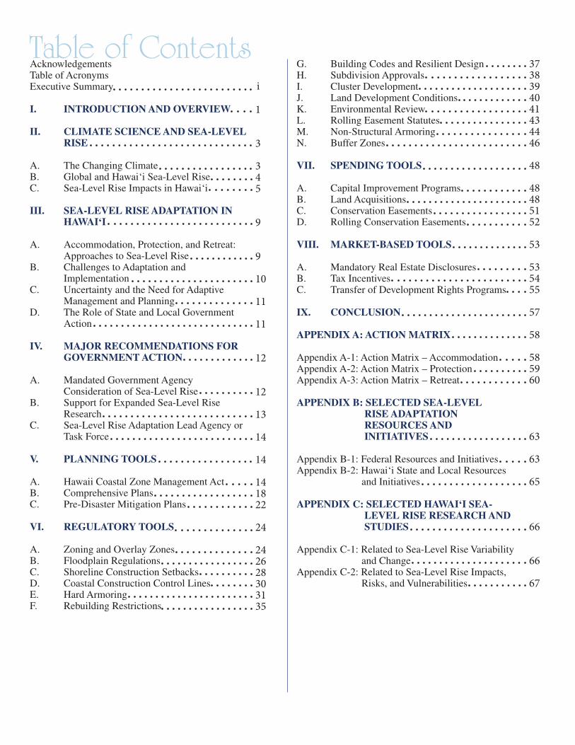
Table of ContentsAcknowledgementsTable of AcronymsExecutive Summary
I. INTRODUCTION AND OVERVIEW
II. CLIMATE SCIENCE AND SEA-LEVEL RISE
A. The Changing ClimateB. Global and Hawai‘i Sea-Level RiseC. Sea-Level Rise Impacts in Hawai‘i
III. SEA-LEVEL RISE ADAPTATION IN HAWAI‘I
A. Accommodation, Protection, and Retreat: Approaches to Sea-Level RiseB. Challenges to Adaptation and ImplementationC. Uncertainty and the Need for Adaptive Management and PlanningD. The Role of State and Local Government Action
IV. MAJOR RECOMMENDATIONS FOR GOVERNMENT ACTION
A. Mandated Government Agency Consideration of Sea-Level RiseB. Support for Expanded Sea-Level Rise ResearchC. Sea-Level Rise Adaptation Lead Agency or Task Force
V. PLANNING TOOLS
A. Hawaii Coastal Zone Management Act B. Comprehensive PlansC. Pre-Disaster Mitigation Plans
VI. REGULATORY TOOLS
A. Zoning and Overlay ZonesB. Floodplain RegulationsC. Shoreline Construction Setbacks D. Coastal Construction Control LinesE. Hard ArmoringF. Rebuilding Restrictions
G. Building Codes and Resilient DesignH. Subdivision ApprovalsI. Cluster DevelopmentJ. Land Development ConditionsK. Environmental ReviewL. Rolling Easement StatutesM. Non-Structural ArmoringN. Buffer Zones
VII. SPENDING TOOLS
A. Capital Improvement ProgramsB. Land AcquisitionsC. Conservation EasementsD. Rolling Conservation Easements
VIII. MARKET-BASED TOOLS
A. Mandatory Real Estate Disclosures B. Tax IncentivesC. Transfer of Development Rights Programs
IX. CONCLUSION
APPENDIX A: ACTION MATRIX
Appendix A-1: Action Matrix – AccommodationAppendix A-2: Action Matrix – ProtectionAppendix A-3: Action Matrix – Retreat
APPENDIX B: SELECTED SEA-LEVEL RISE ADAPTATION RESOURCES AND INITIATIVES
Appendix B-1: Federal Resources and InitiativesAppendix B-2: Hawai‘i State and Local Resources and Initiatives
APPENDIX C: SELECTED HAWAI‘I SEA- LEVEL RISE RESEARCH AND STUDIES
Appendix C-1: Related to Sea-Level Rise Variability and ChangeAppendix C-2: Related to Sea-Level Rise Impacts, Risks, and Vulnerabilities
1
3
345
9
9
10
11
11
12
12
13
14
14
141822
24
242628303135
3738394041434446
48
48485152
53
535455
57
58
585960
63
63
65
66
66
67
i

TABLE OF ACRONYMSCCCL Coastal Construction Control Line
CELCP NOAA Coastal and Estuarine Land Conservation Program
CIP Capital Improvement Program
CRS NFIP Community Rating System
CZM Hawaii Coastal Zone Management Program
DLNR State of Hawai‘i Department of Land and Natural Resources
EA Environmental Assessment
EIS Environmental Impact Statement
FEMA Federal Emergency Management Administration
FIMA Flood Insurance and Mitigation Administration
FIRM Flood Insurance Rate Map
HCDA Hawaii Community Development Authority
HCZMA Hawaii Coastal Zone Management Act
ICAP Center for Island Climate Adaptation and Policy
IPCC United Nations Intergovernmental Panel on Climate Change
NFIP National Flood Insurance Program
NOAA National Oceanic and Atmospheric Administration
OP State of Hawai‘i Office of Planning
ORMP Hawai‘i Ocean Resources Management Plan
PDM Pre-Disaster Mitigation
PDR Purchase of Development Rights
SLR Sea-Level Rise
SFHA Special Flood Hazard Area
SMA Special Management Area
SOEST UH School of Ocean and Earth Science and Technology
TDR Transfer of Development Rights
UH University of Hawai‘i
UH Sea Grant UH Sea Grant College Program
USACE United States Army Corps of Engineers

Executive Summary Rising sea levels along Hawai‘i’s shorelines call for state and local governments to take action by means of a wide range of coastal land use policy tools designed to help Hawai‘i successfully adapt to climate change. Hawai‘i is expected to experience sea-level rise of one foot by 2050 and three feet by the end of the century. Sea-level rise of this magnitude poses significant economic, social, and environmental challenges requiring leadership and bold action by state and local governments, which are uniquely positioned to implement land use policy tools to shape Hawai‘i’s efforts to successfully adapt to rising sea levels in the coming decades.
The purpose of this Tool Kit is to identify and explain key land use policy tools for state and local government agencies and officials to facilitate leadership and action in support of sea-level rise adaptation in Hawai‘i. Across the United States and around the world, governments are developing policy tools to proactively adapt to threats from rising sea levels. For example, the U.S. Army Corps of Engineers now requires consideration of sea-level rise impacts to coastal and estuarine zones in all phases of its civil works programs. In addition to incorporating projected sea-level rise in land use decision-making, experts also recommend that governments locate coastal development where it is protected from hazards, and ensure structures are resilient to flooding and other coastal hazards exacerbated by sea-level rise.
Accordingly, this Tool Kit surveys state adaptation plans, federal efforts, and other key sources to identify and discuss important land use policy tools for Hawai‘i and suggests how these policies can be used by state and local governments to avoid or lessen the impacts of sea-level rise and related coastal hazards. Adaptation planning for sea-level rise and climate change is necessary to protect public health and safety, both now and in the future, and it is widely acknowledged that proactive planning can be more effective and less costly than responding reactively to climate change impacts as they occur. Because sea-level rise and climate change exacerbate existing coastal hazards, adapting now ultimately will lessen future economic, social, and environmental impacts of rising sea levels.
This Tool Kit first reviews scientific research showing that climate change is causing sea-level rise in the Hawaiian Islands and around the world. The physical and environmental impacts of rising sea levels – including coastal erosion, flooding, wave inundation, and rising water tables – are chronicled, as well as the economic and social impacts. The necessity for “adaptive management” in the face of uncertainty is noted, as is the important role to be played by state and local governments in implementing adaptation measures.
i
ii
The Tool Kit next proposes three major actions that state and local governments should consider to move Hawai‘i forward in its efforts to successfully adapt to sea-level rise:
• The governor or state legislature should direct state agencies to incorporate a sea-level rise benchmark of 1-foot-by-2050 and 3-feet-by-2100 in planning and permitting processes and decision-making, similar to the approach taken by the U.S. Army Corps of Engineers and to an executive order issued in California.
• Scientific research must be expanded. Policy tools addressing sea-level rise derive legitimacy from the strength of the supporting science. Funding and support for continued scientific research, ultimately to establish site-specific estimates of sea-level rise impacts, is imperative.
• A lead agency or task force, charged with initiating statewide adaptation planning to
facilitate coordination and collaboration among various agencies and stakeholders, should be established. This entity will increase access to information, promote consistency among adaptation planning efforts, and create the statewide vision that is crucial to successful sea-level rise adaptation.
The Tool Kit also identifies and discusses specific land use policy tools Hawai‘i state and local governments should consider in efforts to address sea-level rise. These policy tools are presented in four main categories: planning tools, regulatory tools, spending tools, and market-based tools.
• Planning tools include the Hawaii Coastal Zone Management Act, comprehensive plans, and pre-disaster mitigation plans.
• Regulatory tools include zoning and overlay zones, floodplain regulations, shoreline construction setbacks, coastal construction control lines, hard armoring, rebuilding restrictions, building codes and resilient design, subdivision approvals, cluster development, land development conditions, environmental review, rolling easement statutes, non-structural armoring, and buffer zones.
• Spending tools include capital improvement programs, land acquisitions, conservation
easements, and rolling conservation easements.
• Market-based tools include mandatory real estate disclosures, tax incentives, and transfer of development rights programs.
Finally, to encourage action and make the Tool Kit ready for use by state and local governments, an action matrix is included as an appendix. The action matrix is organized according to the three major approaches to sea-level rise: accommodation, protection, and retreat. In addition to summarizing the policy tools and initial steps for accommodation, protection, and retreat, each action matrix identifies the lead agency and proposes a time frame for specific state and local government actions. The tools are ranked based on impact and feasibility, with the highest ranking policy tools discussed first.
Executive Summary

1
I.I. INTRODUCTION AND OVERVIEW
Rising sea levels along Hawai‘i’s shorelines call for state and local governments to take action by means of a wide range of coastal land use policy tools designed to help Hawai‘i successfully adapt to climate change. Hawai‘i is expected to experience sea-level rise of one foot by 2050 and three feet by the end of the century. Sea-level rise of this magnitude poses significant economic, social, and environmental challenges. Coastal highways, sewage lines, airport runways, and other public infrastructure may require costly relocation or rebuilding. Hawai‘i’s famed beaches – the lifeblood of local communities as well as the tourism industry – face previously unimagined diminishment. And unique plant and animal life that is unable to adapt may perish. These challenges require leadership and bold action, particularly by state and local governments which are uniquely positioned to implement land use policy tools to shape Hawai‘i’s efforts to successfully adapt to rising sea levels in the coming decades. Such leadership and action is required not only to address the myriad challenges posed by sea-level rise in Hawai‘i, but also to implement measures that draw on the strengths of island communities to adapt to a changing world.
The purpose of this Tool Kit is to identify and discuss key land use policy tools, for use by Hawai‘i state and local government agencies and officials, to facilitate leadership and action in support of successful adaptation to sea-level rise. Across the United States and around the world, governments are developing forward-looking policy tools to proactively adapt to the threats posed by sea-level rise. For example, the U.S. Army Corps of Engineers now requires consideration of sea-level rise impacts to coastal and estuarine zones in all phases of its civil works programs. In addition to incorporating projected sea-level rise in land use decision-making, experts recommend that governments locate coastal development where it is protected from hazards and ensure structures are resilient to flooding and other coastal hazards exacerbated by sea-level rise.
Accordingly, this Tool Kit surveys state adaptation plans, federal efforts, and other key sources to identify important land use policy tools for Hawai‘i and suggests how these policies can be used by state and local governments to avoid or lessen the impacts of sea-level rise and related coastal hazards. Adaptation planning for sea-level rise and climate change is necessary to protect public health and safety, both now and in the future, and it is widely acknowledged that proactive planning can be more effective and less costly than responding reactively to climate change impacts as they occur. Because sea-level rise and climate change exacerbate existing coastal hazards, adapting now ultimately will lessen future economic, social, and environmental impacts.
Waikïkï Beach. View toward Diamond Head. Credit: Dolan Eversole,
NOAA Sea GrantCoastal Storms Program
Coordinator, Pacific Region

2
In sections II and III, this Tool Kit presents the case for adaptation in Hawai‘i. Scientific research demonstrating that climate change is causing sea-level rise in the islands and around the world is briefly reviewed. The physical and environmental impacts of rising sea levels in Hawai‘i – including coastal erosion, flooding, wave inundation, and rising water tables – are chronicled, as well as the economic and social impacts. The necessity for “adaptive management” in the face of uncertainty is noted as is the important role to be played by state and local governments in implementing adaptation measures.
In section IV, the Tool Kit proposes three major actions that state and local governments should consider to move Hawai‘i forward in its efforts to successfully adapt to sea-level rise:
• The governor or state legislature should direct state agencies to incorporate a sea-level rise benchmark of 1-foot-by-2050 and 3-feet-by-2100 in planning and permitting processes and decision-making, similar to the approach taken by the U.S. Army Corps of Engineers and to an executive order issued in California.
• Scientific research must be expanded. Policy tools addressing sea-level rise derive legitimacy from the strength of the supporting science. Funding and support for continued scientific research, ultimately to establish site-specific estimated of sea-level rise impacts, is imperative.
• A lead agency or task force, charged with initiating statewide adaptation planning to facilitate coordination and collaboration among various agencies and stakeholders, should be established. This entity will increase access to information, promote consistency among adaptation planning efforts, and create the statewide vision that is crucial to successful sea-level rise adaptation.
In sections V through VIII, the Tool Kit identifies and discusses specific land use policy tools Hawai‘i state and local governments may consider in efforts to address sea-level rise. These policy tools are presented in four main categories: planning tools, regulatory tools, spending tools, and market-based tools.
• Planning tools include the Hawaii Coastal Zone Management Act, comprehensive plans, and pre- disaster mitigation plans.
• Regulatory tools include zoning and overlay zones, floodplain regulations, shoreline construction setbacks, coastal construction control lines, hard armoring, rebuilding restrictions, building codes and resilient design, subdivision approvals, cluster development, land development conditions, environmental review, rolling easement statutes, non-structural armoring, and buffer zones.
• Spending tools include capital improvement programs, land acquisitions, conservation easements, and rolling conservation easements.
• Market-based tools include mandatory real estate disclosures, tax incentives, and transfer of development rights programs.
Finally, to encourage action and make the Tool Kit ready for use by state and local governments, an action matrix is included as an appendix. The action matrix is organized according to the three major approaches to sea-level rise: accommodation, protection, and retreat. In addition to summarizing the policy tools and initial steps for accommodation, protection, and retreat, each action matrix identifies the lead agency and proposes a time frame for specific state and local government actions. The tools are ranked based on impact and feasibility, with the highest ranking policy tools discussed first.
3
II.II. CLIMATE SCIENCE AND SEA-LEVEL RISE
Scientific research provides the foundation for effective action by state and local government decision-makers on climate change and sea-level rise adaptation in Hawai‘i. Current science documents the environmental and socio-economic impacts of climate change. Implementation of the planning, regulatory, spending and market-based policy tools discussed in this Tool Kit is supported by existing and ongoing scientific research.
A. The Changing Climate
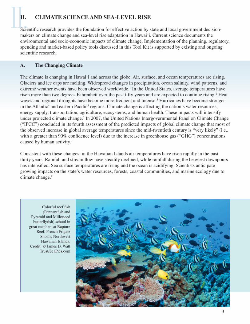
The climate is changing in Hawai‘i and across the globe. Air, surface, and ocean temperatures are rising. Glaciers and ice caps are melting. Widespread changes in precipitation, ocean salinity, wind patterns, and extreme weather events have been observed worldwide.1 In the United States, average temperatures have risen more than two degrees Fahrenheit over the past fifty years and are expected to continue rising.2 Heat waves and regional droughts have become more frequent and intense.3 Hurricanes have become stronger in the Atlantic4 and eastern Pacific5 regions. Climate change is affecting the nation’s water resources, energy supply, transportation, agriculture, ecosystems, and human health. These impacts will intensify under projected climate change.6 In 2007, the United Nations Intergovernmental Panel on Climate Change (“IPCC”) concluded in its fourth assessment of the predicted impacts of global climate change that most of the observed increase in global average temperatures since the mid-twentieth century is “very likely” (i.e., with a greater than 90% confidence level) due to the increase in greenhouse gas (“GHG”) concentrations caused by human activity.7
Consistent with these changes, in the Hawaiian Islands air temperatures have risen rapidly in the past thirty years. Rainfall and stream flow have steadily declined, while rainfall during the heaviest downpours has intensified. Sea surface temperatures are rising and the ocean is acidifying. Scientists anticipate growing impacts on the state’s water resources, forests, coastal communities, and marine ecology due to climate change.8
Colorful reef fish (Pennantfish and
Pyramid and Milletseed butterflyfish) school in
great numbers at Rapture Reef, French Frigate
Shoals, Northwest Hawaiian Islands.
Credit: © James D. Watt Trust/SeaPics.com

B. Global and Hawai‘i Sea-Level Rise
Sea levels in Hawai‘i and elsewhere are rising due to climate change. The global mean sea level rose approximately six to eight inches over the past century, after at least 2,000 years of little change.9 Since 1990, the rate of global sea-level rise has approximately doubled and will continue accelerating in response to global warming.10 Scientists project that the global mean sea level may rise approximately 1 foot by mid-century11 and 2.5 to 6.2 feet by the end of the century due to sea water thermal expansion and melting ice sheets.12 Even if GHG concentrations were stabilized today, sea levels are projected to rise for hundreds of years.13
4
Although the global trend indicates a rise in the mean level of the oceans, there are marked regional differences that vary between -10 and +10 mm/year. Isolated variations in mean sea level occur mainly due to tradewind-driven currents. Credit: CLS/Cnes/Legos
Various global mean sea level estimates for the year 2100.The yellow sea-level rise range is being utilized in Hawai‘i for sea-level rise mapping purposes. Credit: Dr. Charles Fletcher, University of Hawai‘i (after S. Rahmstorf, New View on Sea Level Rise, Nature Reports Climate Change, Apr. 6, 2010)

C. Sea-Level Rise Impacts in Hawai‘i
Sea-level rise can intensify the effects of coastal hazards and processes by making coastal areas more vulnerable to wave inundation, hurricanes, and tsunamis19 and contributing to more frequent and extreme high water events.20 Long-term sea-level rise will exacerbate chronic coastal erosion, flooding, and drainage problems.21 Water table levels are closely tied to sea levels; as sea levels rise, groundwater may break through land surfaces under roads, buildings, and houses. High water tables also prevent rainwater from filtering into the ground. Compounded with high tides, heavy rains, and high surf, high water tables may lead to large-scale inundation of low-lying areas22 including coastal roads and Hawai‘i communities.23 As sea levels rise and shorelines erode, coastal land may be permanently lost.24
In the Hawaiian Islands, sea levels rose six inches over the past century.14 For various reasons, sea-level rise in the region around the main Hawaiian Islands lags behind the current acceleration in the global mean sea level.15 In addition to this lag, it has been projected that “[m]ore plausible but still accelerated conditions [may] lead to total [global mean] sea-level rise by 2100 of about 0.8 meter (2.62 feet).”16 Hawai‘i sea-level rise therefore will likely fall in the lower projected range by 2100.
Consistent with this scientific understanding, this Tool Kit recommends that state and local decision-makers begin planning for sea-level rise of approximately 1 foot by 2050 and 3 feet by 2100,17 with reevaluation of this benchmark upon release of the Fifth Assessment Report of the IPCC in 2014.18 This basic sea-level rise figure is referred to throughout this Tool Kit as the 1-foot-by-2050 and 3-feet-by-2100 benchmark.
5
Sea-level rise trends in Honolulu, Hawai‘i.
Credit: Dr. Mark Merrifield, University of
Hawai‘i Sea Level Center
6
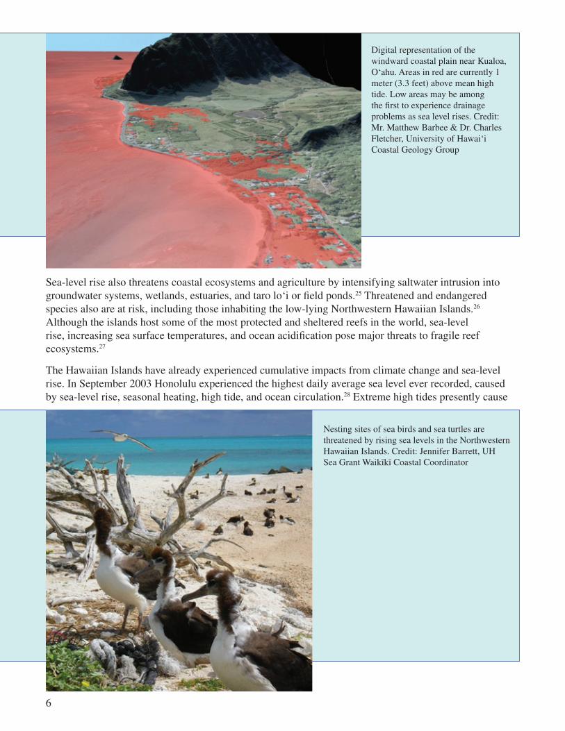
Sea-level rise also threatens coastal ecosystems and agriculture by intensifying saltwater intrusion into groundwater systems, wetlands, estuaries, and taro lo‘i or field ponds.25 Threatened and endangered species also are at risk, including those inhabiting the low-lying Northwestern Hawaiian Islands.26 Although the islands host some of the most protected and sheltered reefs in the world, sea-level rise, increasing sea surface temperatures, and ocean acidification pose major threats to fragile reef ecosystems.27
The Hawaiian Islands have already experienced cumulative impacts from climate change and sea-level rise. In September 2003 Honolulu experienced the highest daily average sea level ever recorded, caused by sea-level rise, seasonal heating, high tide, and ocean circulation.28 Extreme high tides presently cause
Digital representation of the windward coastal plain near Kualoa, O‘ahu. Areas in red are currently 1 meter (3.3 feet) above mean high tide. Low areas may be among the first to experience drainage problems as sea level rises. Credit: Mr. Matthew Barbee & Dr. Charles Fletcher, University of Hawai‘i Coastal Geology Group
Nesting sites of sea birds and sea turtles are threatened by rising sea levels in the Northwestern Hawaiian Islands. Credit: Jennifer Barrett, UH Sea Grant Waikïkï Coastal Coordinator

7
There is irrefutable evidence that global warming is real and occurring at an alarming rate. As the planet warms over the next fifty years, sea levels are rising, impacting our coastal areas. Hawai‘i could also be struck by stronger and more frequent storms because of these changes. Homes, hotels, businesses, harbors and waterfront properties are increasingly at risk. We must aggressively address the impact of global warming and rising sea levels for our island state. Our state has some of the best scholars and researchers in the world housed at the University of Hawai‘i. We must take advantage of their expertise and ensure that we are prepared to address the realities of climate change.
Hawai‘i 2050 Sustainability Plan.31
In 2007, the Hawai‘i Legislature acknowledged the impacts of climate change by passing major legislation, known as Act 234, to mitigate GHG emissions. Affirming that “climate change poses a serious threat to the economic well-being, public health, natural resources, and the environment of Hawaii,”32 Act 234 specifically found the potential adverse effects of global warming include rising sea levels, which would result in displacement of businesses and residences and harm to the tourism industry. Other adverse effects identified by Act 234 include damage to marine ecosystems and the natural environment, extended drought and loss of soil moisture, an increase in the spread of infectious diseases, and the severity of storms and extreme weather events, and harm to agriculture, recreation, commercial fishing, and forestry.33
Flooding in the Mapunapuna area of Honolulu due to heavy
rains and high tides. The storm drain system, located
below sea level, was retrofitted with one-way drains and the
flooding was largely mitigated. Credit: D. Oda
drainage problems in developed areas where intensifying storm runoff and rising ocean waters intersect.29 For example, until specialized one-way flow vents were recently installed, high tides occasionally caused the ocean to flow through the drainage system onto streets in the Mapunapuna industrial area in Honolulu.30

8
Sea-level rise will further burden Hawai‘i’s coastal infrastructure, including transportation assets and energy and wastewater delivery systems, some of which currently require billions of dollars in repairs and upgrading.34 This is consistent with the U.S. Global Change Research Program estimate that sea-level rise of 0.5 meters (1.64 feet) by 2100 will cause an estimated $23-170 billion in property damage to U.S. coastal properties.35 The Federal Emergency Management Agency (“FEMA”) has similarly concluded that sea-level rise of 1-foot by 2100 would increase expected losses associated with its National Flood Insurance Program (“NFIP”) of $150 million annually, while a 3-foot rise would increase expected losses by $600 million annually.36 Sea-level rise, heavier downpours, and additional storm activity are expected to increase the nation’s floodplain by 40-45% over the next ninety years, thus expanding the NFIP beyond its current volume of 5.6 million policies valued at $1.2 trillion.37
Hawai‘i has suffered significant socio-economic losses from inundation and other coastal hazards. Continued climate change and sea-level rise is anticipated to exacerbate inundation-related losses.38 Storms in late 2003 and early 2004 inundated many businesses with several feet of water. The December 7-8, 2003 storm alone caused damages estimated at $20 million.39 Additionally, the state’s hurricane losses from 1957-1995 surpassed $2.7 billion. Hurricane Iniki, the most powerful hurricane to hit the state, caused seven deaths, $2 billion in damage, and required $295 million in FEMA disaster relief in 1992.40 And the March 11, 2011 tsunami damaged fifty-two businesses and twenty-six homes in Kailua-Kona and Kealakekua Bay in Hawai‘i County, with losses estimated at $2.5 million and $11.1 million, respectively.41
In addition to infrastructure and inundation issues, sea-level rise threatens Hawai‘i’s tourism industry, which comprises 26% of the state’s economy.42 In 2006, tourism brought more than seven million visitors and generated more than $12.4 billion for the state.43 Waikīkī alone supports 11% of the state’s civilian jobs, provides 12% of state and local tax revenues, and generates 46% of statewide tourism revenues.44 The loss of Waikīkī beach risks forfeiting $2 billion annually in overall visitor expenditures45 and 6,352 hotel jobs.46 Rising sea levels and increasing ocean temperatures also harm coral reef systems, which draw visitors from around the world.47 Sea-level rise of 0.5 meters (1.64 feet) would also place Waikīkī and other critical areas the flood hazard zone.48
Annual high tides, such as this one at Waikïkï Beach in 2009, will become more frequent as sea level rises. Credit: Chris Conger, University of Hawai‘i Sea Grant College Program

III.III. SEA-LEVEL RISE ADAPTATION IN HAWAI‘I
Effective state and local government leadership on climate adaptation will be aided by understanding the three related approaches of accommodation, protection, and retreat; embracing the necessity for “adaptive management” to deal with uncertainty; and appreciating the unique role of state and local governments in tackling climate change and sea-level rise in Hawai‘i.
A. Accommodation, Protection, and Retreat: Approaches to Sea-Level Rise This Tool Kit focuses on climate change adaptation rather than mitigation, or the parallel effort to reduce the GHG emissions that cause climate change.49 Pursuant to Act 234, noted above, Hawai‘i must reduce or mitigate GHG emissions that cause climate change to amounts at or below1990 levels by the year 2020.50 Although governments throughout the world have adopted similar mitigation policies, the success of such policies remains uncertain.51 Even if these policies succeed, historic emissions will continue to cause climate change, and adaption measures are necessary to address unavoidable impacts.52 Drawing attention to adaptation may support mitigation efforts by highlighting the future consequences of climate change.53 In short, both mitigation and adaptation measures should be implemented to decrease the risks associated with climate change.54
Unlike mitigation, the goal of climate change adaptation is to avoid, withstand, or take advantage of current and projected climate change by decreasing vulnerabilities and increasing resilience.55 Adaptive responses can be achieved through planning and policy, in addition to technological, behavioral, and managerial measures.56 Three basic approaches to sea-level rise adaptation have been identified:
9
Access to Honolulu International Airport runways would be compromised with a 3-foot rise in sea level (left). A 3-foot rise in sea level also would impact stormwater drainage in the high-density Ala Moana commercial area (right). Credit: Mr. Matthew Barbee & Dr. Charles Fletcher, University of Hawai‘i Coastal Geology Group

• Accommodation. Adjustment of an existing system to changing natural conditions (e.g., strengthening flood-proofing regulations or expanding hazard zones).
• Protection. Hardening of a system in its existing location to withstand impacts from changing conditions (e.g., shoreline hardening such as seawalls and revetments).
• Retreat. Relocating existing structures to avoid impacts.57
Hawai‘i stakeholders have acknowledged accommodation, protection, and retreat as basic responses to climate change. In 2010, ICAP conducted interviews with eighteen state government decision-makers and staff with coastal management responsibilities to better understand perceptions of the relationship between state agencies and sea-level rise. Interviewees recommended accommodation, with regard to shoreline planning and coastal hazard zones, by updating and amending flood and tsunami maps, shoreline construction setbacks, building codes, and zoning. Managed retreat was recommended for critical infrastructure near the shoreline. And protection was recommended for critical infrastructure that cannot be relocated and for coastal areas with existing seawalls.58
B. Challenges to Adaptation and Implementation
The ICAP interviewees identified four major obstacles to long-term sea-level rise adaptation planning:
• Government and public resistance to acknowledging sea-level rise (i.e., skepticism concerning human-caused climate change);
• Limited effectiveness of resource management to address a “slowly emerging disaster” (e.g., overlapping state and county regulatory jurisdictions, irregularities in the law, and political resistance and legal challenges);
• Environmental and social justice concerns (e.g., equitable allocation of protection measures for varying degrees and types of shoreline development); and
• Government incentives that shield property owners from the risks of their decisions (e.g., FEMA policies and flood insurance programs that incentivize rebuilding in vulnerable areas).60
Additional challenges include the tendency for the public and decision-makers to focus on near-term rather than long-term threats, lack of political leadership, the need for interagency cooperation, and resource scarcity. In addition, property owners are likely to resist vacating coastal properties and removing sea walls in response to enforcement of shoreline retreat policies. Variance, permitting, and enforcement decisions may trigger regulatory takings claims, as discussed in the ICAP publication Climate Change and Regulatory Takings in Coastal Communities.61
Effective, innovative adaptation approaches minimize public safety risks and impacts to critical infrastructure; maximize compatibility with and integration of natural processes; are resilient over a range of sea levels, potential flooding impacts and storm intensities; and are adaptively managed.
San Francisco Bay Conservation and Development Commission59
10

11
C. Uncertainty and the Need for Adaptive Management and Planning
Like government agencies elsewhere, Hawai‘i decision-makers face uncertainty in planning for sea-level rise and climate change. Uncertainties include the timing and extent of impacts, refinements to scientific models and predictive tools, the relative effectiveness of adaptive measures, advances in adaptation technology, and the role of federal initiatives.64 Effective decision-making in the face of uncertainty requires adaptive management and planning that explicitly allows for flexibility to accommodate new data, perceptions, and vulnerability assessments.65 Accordingly, decision-makers adapt and modify the way they manage a problem as more information becomes available66 and make similar adjustments throughout planning processes, which involve the identification and assessment of impacts, the development of goals and actions to minimize impacts, and the establishment of a process for implementing actions.67 Using adaptive management and planning, decisions are made in an experimental context, acknowledging that some actions will fail and opportunities for more effective options will arise based upon new information and prior experience.68
Despite these obstacles, sea-level rise and climate change adaptation and planning are necessary to protect public health and safety now and in the future. Proactive planning can be more effective and less costly than responding reactively to climate change impacts as they occur.62 Advance planning can add value by reducing future risk and increasing future benefits. And because sea-level rise will amplify the effects of known coastal hazards, adaptation planning designed to address coastal hazards will offer immediate benefits.63 This “no regrets” approach, which offers both current and future benefits, is recommended to overcome challenges to the implementation of adaptation measures.
D. The Role of State and Local Government Action
Hawai‘i state and local governments are uniquely positioned to implement adaptation policies because they exercise authority over coastal resources through land use planning, zoning, subdivision controls, capital investment programs,70 building codes, and transportation infrastructure.71 Although the federal government has provided support and taken preliminary legal and regulatory steps, state and local governments remain at the front lines of climate change and sea-level rise adaptation. Each region in the country will experience impacts differently,72 and many state and local governments have begun planning and enacting localized strategies for adapting to climate change. For example, fifteen states have either completed or are currently developing climate adaptation plans. Nine states have recommended developing adaptation plans in their climate action plans.73 Recent California legislation proposed requiring public lands trustees to develop sea-level rise adaptation plans by July 1, 2013.74
Adaptive management is a cyclic, learning-oriented approach that is especially useful for complex environmental systems characterized by high levels of uncertainty about system processes and the potential for ecological, social and economic impacts from alternative management options. Effective adaptive management requires setting clear and measurable objectives, collecting data, reviewing current scientific observations, monitoring the results of policy implementation or management actions, and integrating this information into future actions.
San Francisco Bay Conservation and Development Commission69
12
IV.IV. MAJOR RECOMMENDATIONS FOR GOVERNMENT ACTION There is a strong consensus among stakeholders and decision-makers that effective sea-level rise adaptation planning in Hawai‘i will require government leadership.78 Legislation or executive orders authorizing such planning can help to ensure adequate resources, support, and legitimacy79 while promoting statewide consistency among various planning efforts.80 Such legal mandates will promote awareness and guide decision-making by acknowledging climate change vulnerabilities and prioritizing adaptation.81 To provide essential leadership for statewide sea-level rise planning, this Tool Kit recommends legislation or executive orders:
• Directing state agencies to incorporate a sea-level rise benchmark of 1-foot-by-2050 and 3-feet-by-2100 in planning and permitting processes and decision-making;
• Supporting expanded sea-level rise research; and
• Designating a lead agency or establishing a task force charged with initiating statewide climate change and sea-level rise adaptation planning.
Legal mandates in these areas will help to equip government decision-makers with the tools necessary for adapting to sea-level rise.
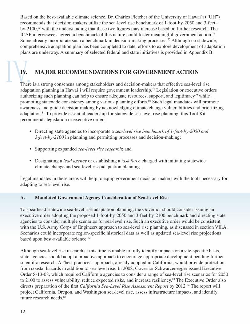
Based on the best-available climate science, Dr. Charles Fletcher of the University of Hawai‘i (“UH”) recommends that decision-makers utilize the sea-level rise benchmark of 1-foot-by-2050 and 3-feet-by-2100,75 with the understanding that these two figures may increase based on further research. The ICAP interviewees agreed a benchmark of this nature could foster meaningful government action.76 Some already incorporate such a benchmark in decision-making processes.77 Although no statewide, comprehensive adaptation plan has been completed to date, efforts to explore development of adaptation plans are underway. A summary of selected federal and state initiatives is provided in Appendix B.
A. Mandated Government Agency Consideration of Sea-Level Rise To spearhead statewide sea-level rise adaptation planning, the Governor should consider issuing an executive order adopting the proposed 1-foot-by-2050 and 3-feet-by-2100 benchmark and directing state agencies to consider multiple scenarios for sea-level rise. Such an executive order would be consistent with the U.S. Army Corps of Engineers approach to sea-level rise planning, as discussed in section VII.A. Scenarios could incorporate region-specific historical data as well as updated sea-level rise projections based upon best-available science.82
Although sea-level rise research at this time is unable to fully identify impacts on a site-specific basis, state agencies should adopt a proactive approach to encourage appropriate development pending further scientific research. A “best practices” approach, already adopted in California, would provide protection from coastal hazards in addition to sea-level rise. In 2008, Governor Schwarzenegger issued Executive Order S-13-08, which required California agencies to consider a range of sea-level rise scenarios for 2050 to 2100 to assess vulnerability, reduce expected risks, and increase resiliency.83 The Executive Order also directs preparation of the first California Sea-Level Rise Assessment Report by 2012.84 The report will project California, Oregon, and Washington sea-level rise, assess infrastructure impacts, and identify future research needs.85

13
USACE Sea-Level Rise Scenarios: Modified NRC (1987) eustatic
sea-level rise scenarios and the IPCC (2007)
scenario estimates for use in predicting future
sea-level change.Source: USACE, Water
Resource Policies and Authorities
Incorporating Sea-Level Change in Civil Works
Programs (Jul. 1, 2009)
B. Support for Expanded Sea-Level Rise Research
Additional funding is critical to expand research so that decision-makers and property owners understand the potential impacts of sea-level rise on a site-specific basis. Maps and models that identify risks and vulnerabilities on a smaller scale can facilitate government and private adaptation measures by identifying specific threats to properties and public health and safety.86 The state should support scientific research for sea-level rise adaptation by:
• Providing funding for continued studies of sea-level rise variability in Hawai‘i;
• Providing funding for expanding the scope of risk and vulnerability assessments to account for all low-lying and coastal areas throughout the state;
• Researching other federal funding and partnership opportunities; and
• Developing an outreach program for communicating sea-level rise research to decision-makers and the public.
Adaptation measures rely on scientific research into two major areas, sea-level rise variability and sea-level rise impacts and risks.87 Selected Hawai‘i research efforts in both areas are summarized in Appendix C.
Sea level rise and coastal erosion could threaten the coastal built environment and significantly increase loss of beaches, coastal ecosystems, and buildings. Tourism resources along the beach could be reduced and this would impact the economy. More data and assessment are needed to understand the full reach of the impacts from climate change.
State of Hawai‘i Multi-Hazard Mitigation Plan 2010 Update88
14
C. Sea-Level Rise Adaptation Lead Agency or Task Force
Designating a lead agency or establishing a state interagency task force charged with initiating statewide sea-level rise adaptation planning is recommended to strengthen adaptation efforts by facilitating coordination and collaboration among various agencies and stakeholders. This also would increase access to best-available resources and information89 and promote consistency among adaptation planning efforts.90 Responsibilities could include creating a vision for statewide sea-level rise adaptation, assessing vulnerabilities and impacts, identifying gaps in data and information, establishing planning and research goals, developing recommendations and implementation actions, and updating assumptions, benchmarks, and plans as climate change and sea-level rise data become more robust.91 As a more specific example, the agency or task force could assist with evaluating flood hazards for planned light rail construction sites.92
Several states have designated lead agencies or established task forces for developing climate change adaptation strategies and plans, many of which address sea-level rise.93 For example, in 2007 the New York legislature created a sea-level rise task force within the Department of Environmental Conservation. The task force, comprised of sixteen members from various sectors of state, county, and city government, was charged with developing a report to assess sea-level rise impacts and provide adaptation recommendations regarding a variety of factors, including coastline development and hardening, post-disaster recovery, natural habitats and ecosystems, drinking water supplies, and regulatory and statutory alterations.94
A. Hawaii Coastal Zone Management Act
The Hawaii Coastal Zone Management Act (“HCZMA”), codified in Chapter 205A of the Hawaii Revised Statutes, is an important planning tool for regulating development and land use within the coastal zone. The HCZMA is implemented through a “networked/local” coastal program under which State of Hawai‘i Office of Planning (“OP”) serves as the state’s designated lead agency and coordinates coastal zone activities statewide, and county permitting authorities administer the special management area (“SMA”) permit system.95 State and county agencies must adopt and enforce rules that comply with HCZMA objectives and policies.96 These policies relate to ten areas: recreational resources, historic resources, scenic and open space resources, coastal ecosystems, economic uses, coastal hazards, managing development, public participation, beach protection, and marine resources.97 Counties must adopt similar guidelines for regulating development within the SMA.98 Under the HCZMA, counties establish SMA boundaries and setback lines and exercise authority over permits and variances in the SMA.99
V.V. PLANNING TOOLS
Consistent with the foregoing major recommendations for government action, this Tool Kit next provides a summary overview of selected land use-related policy tools for consideration by state and local government decision-makers in addressing sea-level rise. In addition to the planning tools discussed in this section, policy tools under the headings of Regulatory Tools, Spending Tools, and Market-Based Tools are also surveyed. The discussion of each policy tool includes a basic description of the tool, recommendations for future action, and a brief discussion of potential barriers to implementing the tool. Under each major section (Planning, Regulatory, Spending, and Market-Based), the tools are ranked based on impact and feasibility, with the highest ranking policy tools discussed first.

1. Recommendations and Next Steps
The HCZMA’s codified objectives and policies may provide a sufficient basis for climate adaptation measures such as amending shoreline construction setbacks (discussed in section VI.C of this Tool Kit), implementing coastal construction control lines (“CCCLs”) (section VI.D) and regulating hard armoring and non-structural armoring (sections VI.E and VI.M). For example, the HCZMA objective to “[r]educe hazard to life and property from tsunami, storm waves, stream flooding, erosion, and pollution”100 requires government to:
• Develop and communicate adequate information about storm wave, tsunami, flood, erosion, subsidence, and point and nonpoint source pollution hazards;
• Control development in areas subject to storm wave, tsunami, flood, erosion, subsidence, and point and nonpoint source pollution hazards;
• Ensure that developments comply with requirements of the Federal Flood Insurance Program; and
• Prevent coastal flooding from inland projects.101
Because sea-level rise will exacerbate the effects of many coastal hazards,102 this language can serve to justify decision-making on permits, approvals, and variances that reduces threats to life and property. Although its current language is generally supportive, the HCZMA should be amended to more explicitly mandate sea-level rise adaptation by:
• Explicitly including sea-level rise in the list of coastal hazards detailed in HCZMA objectives and policies;
• Incorporating a new set of objectives and policies that specify goals for accommodation, protection, and/or retreat in response to climate change and sea-level rise;
• Implementing development restrictions related to climate change and sea-level rise;
15
Hawaiian monk seal.Credit: © James D. Watt Trust/
SeaPics.com

16
Sea level rise in this century is a scientifically documented fact. Our shoreline is suffering from its effects today. It must be accepted that regardless of attempts to forestall the process, the Atlantic Ocean, as a result of sea level rise and periodic storms, is ultimately going to force those who have built too near the beachfront to retreat. . . . [T]he long-range public good is the same as the long-range private good. If the dry sand beaches of this State disappear because of the failure of its people and governmental natural resource managers to protect the beach/dune system, future generations will never have the opportunity to use and enjoy this valuable resource.
South Carolina Code of Regulations103
Under the South Carolina Coastal Zone Management Act, the Department of Health and Environmental Control implemented a forty-year retreat policy to adapt to erosion caused by sea-level rise and periodic storms.104 The policy rejects the use of erosion control devices, adopts retreat and renourishment as the basic approach towards preserving and restoring the state’s beaches, and designates a baseline and setback line on all oceanfront properties. It also mandates that the Department of Health and Environmental Control require property owners to move new construction and reconstruction as far landward as possible, to limit the size of coastal structures, and to seek innovative ways to ameliorate the effects of beach erosion.105
• Requiring more restrictive conditions to be imposed on variances and SMA permits or modifying laws and rules to make variances and permits more difficult to obtain; and
• Adding a new part to the HCZMA regarding climate change and sea-level rise that details objectives, policies, priorities, and implementation strategies for adaptation.
Variances to the SMA rules are often allowed under emergency conditions. Credit: Andrew Bohlander, UH Sea Grant Shoreline Specialist

17
The Rhode Island Coastal Resources Management Council, which is statutorily enabled to manage and plan for the preservation of the state’s coastal resources,106 added a “Climate Change and Sea Level Rise” section to its Coastal Resources Management Program in 2008.107 The section adopts three policies for sea-level rise and climate change adaptation. First, the council will review its policies, plans, and regulations to proactively plan for sea-level rise and climate change. Second, the council states that the purposes of the policies are to preserve, protect, and where possible, restore coastal resources through coordinated long-range planning. Third, the council’s planning and management will accommodate a base rate of 3- to 5-foot rise in sea level by 2100 into the siting, design, and implementation of public and private coastal activities. The policy also recognizes that the lower the sea-level rise estimate used, the greater the risk that adaptation efforts will prove inadequate. While employing practices related to adaptive management and planning, the council will take into account different risk tolerances for differing types of coastal activities and will revisit this base rate with new scientific evidence.108
Under the Maine Coastal Zone Management Act, the legislature adopted a policy for all state and local agencies to “[d]iscourage growth and new development in coastal areas where, because of coastal storms, flooding, landslides, or sea-level rise, it is hazardous to human safety.”109 Under the Coastal Sand Dune Rules, “A project may not be permitted if, within 100 years, the property may reasonably be expected to be eroded as a result of changes to the shoreline such that the project is likely to be severely damaged after allowing for a two foot rise in sea level over 100 years,” excluding beach nourishment and sand dune restoration projects.110
And the County of Duck, North Carolina, Coastal Areas Management Act Core Land Use Plan states the following objectives that relate to sea-level rise adaptation: “Develop policies that minimize threats to life, property, and natural resources resulting from development located in or adjacent to hazard areas, such as those subject to erosion, high winds, storm surge, flooding, or sea level rise”; “[d]evelop location, density, and intensity criteria for new, existing development and redevelopment including public facilities and infrastructure so that they can better avoid or withstand natural hazards”; and to “[d]evelop, adopt, and enforce, and amend as necessary, a shoreline overlay zoning district to address development, redevelopment, and uses along shorelines and in adjacent waters.”111 County ordinances mandate a short-term moratorium on post-disaster reconstruction and enable a special reconstruction task force to identify opportunities to mitigate future damages through the management of reconstruction.112
2. Overcoming Barriers
The HCZMA requires state and county agencies to consider the need for economic development when implementing objectives and policies.113 Although economic development is an important policy objective, if economic interests unduly influence the decision-making process with regard to permits, variances, and other land use decisions, the public safety and environmental protection functions of the HCZMA may lack sufficient priority. To address sea-level rise concerns, the HCZMA should be interpreted and enforced
B. Comprehensive Plans
Comprehensive statewide and county plans can play an important role in shaping Hawai‘i’s response to sea-level rise. Hawai‘i became the first state in the nation to enact a statewide comprehensive land use plan when the Legislature passed the Hawaii State Planning Act in 1978.115 The Hawaii State Plan provides broad goals, objectives, policies, and priority guidelines for directing future long-range development.116 It details specific requirements for state functional plans, county general plans, and development plans, each of which must conform to the State Plan.117 Funding appropriations, capital improvements, budgetary reviews and allocations, state land use decisions, and state programs all must conform to the State Plan and functional plans.118
Guided by the State Plan, each county has adopted a general plan with varying degrees of authority over county agencies, planning, and ordinances. Counties are also governed by specific development plans (City and County of Honolulu and Kaua‘i County),119 sustainable communities plans (City and County of Honolulu),120 community plans (Maui County),121 and community development plans (Hawai‘i County).122
Although sea-level rise is not specifically called out in Hawai‘i’s statewide plan, sustainability is a priority. Pursuant to Act 181 (signed into law in July 2011 and the first substantive change to the State Plan since the 1990s),123 sustainability is one of six priority guidelines,124 the goal of which is to achieve:
18
in a manner that achieves the law’s economic and environmental policy objectives by acknowledging the threats posed by sea-level rise and fostering support for a hazard-based approach to planning and land use decision-making. In addition, landowners often have strong financial and emotional ties to coastal properties. Regulatory takings claims against state and local governments are possible. Guidance from the HCZMA, executive orders, laws, ordinances, plans, and the best-available science will further strengthen use of the HCZMA by state and local governments to promote adaptation in a manner that withstands potential legal challenges.
Finally, in contrast to Hawai‘i’s “networked/local” coastal program, certain states such as South Carolina and Rhode Island operate under “direct” coastal programs in which designated state agencies have more authority to regulate activities within the coastal zone.114 The relatively diffuse authority in Hawai‘i may hamper the ability to implement sea-level rise-related HCZMA policies and regulations.
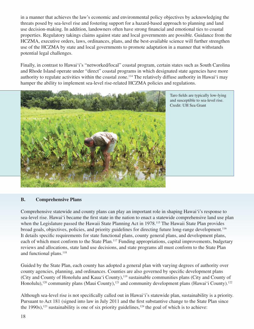
Taro fields are typically low-lying and susceptible to sea-level rise. Credit: UH Sea Grant

19
1. Recommendations and Next Steps
Although neither the State Plan nor the 2011 sustainability amendments directly address sea-level rise, they provide a basis for implementing climate change and sea-level rise adaptation. For example, the State Plan directs agencies to “[r]educe the threat to life and property from erosion, flooding, tsunamis, hurricanes, volcanic eruptions, and other natural or man-induced hazards and disasters.”131 Because sea-level rise will exacerbate the effects of several of these hazards,132 reducing threats to life and property from sea-level rise could be considered an inherent State Plan objective requiring varying degrees of conformance among state and county programs and plans. The following recently enacted priority guidelines for sustainability further support climate adaptation:
• Encouraging balanced economic, social, community, and environmental priorities;
• Encouraging planning that respects and promotes living within the natural resources and limits of the State;
• Promoting a diversified and dynamic economy;
• Encouraging respect for the host culture;
• Promoting decisions based upon meeting the needs of the present without comprising the needs of future generations;
• Considering the principles of the ahupua‘a system (a traditional Hawaiian land use division extending from the uplands to the ocean); and
• Emphasizing that everyone, including individuals, families, communities, businesses, and government, has the responsibility for achieving a sustainable Hawai‘i.133
Like the HCZMA, the Hawai‘i Legislature should consider amending state planning statutes to more directly address climate change and sea-level rise adaptation. An existing priority guideline under the State Plan is to “[d]irect future urban development away from critical environmental areas or impose mitigating measures so that negative impacts on the environment would be minimized.”134 This guideline dovetails with sea-level rise concerns and could be modified accordingly. The Hawai‘i Legislature also could consider adding new climate change and sea-level rise priority guidelines to the State Plan. Counties could similarly amend general plans to more explicitly address sea-level rise. County general plans are relatively more detailed and region-specific and in some instances may be updated more frequently. Similarly, redevelopment plans for certain agencies could be required to consider development risks from sea-level rise. For example, the Hawaii Community Development Authority (“HCDA”) is subject to tailored land use regulations and has jurisdiction over coastal properties impacted by sea-level rise.135
“[r]espect of the culture, character, beauty, and history of the State’s island communities; [s]triking a balance between economic, social, and environmental priorities; and [m]eeting the needs of the present without compromising the ability of future generations to meet their own needs.”125
Sustainability joins the ranks of the five preexisting priority guidelines: economic development, population growth and land resource management, affordable housing, crime and criminal justice, and quality education.126 Priority guidelines such as sustainability “shall take precedence when addressing areas of statewide concern,”127 and provide guidance for state programs,128 county general plans,129 and state functional plans.130

20
Conservative estimates suggest the sea level may rise up to 1 meter by 2100. Projected sea-level rise over the next 20 years would increase at an exponential rate and would impact all coastlines, most severely affecting Ma‘alaea, North Kihei, Lahaina, Ka‘anapali, Kahului, and Kaunakakai. Prudent planning will consider projected sea-level rise as a variable in planning for each island. . . . Unlike most communities in the United States, the boundaries of Maui, Lana‘i, and Moloka‘i are finite and cannot be enlarged through annexation. In fact, because of sea-level rise, it is probable that some of the County’s land will not be accessible in the coming years. The coastlines, even as they change, will remain boundaries, and all land uses today and for future generations must be accommodated within these natural parameters. Therefore, it is of utmost importance to carefully consider choices regarding land use and the location of future development and how the County uses its limited resources.
Maui 2030 General Plan136
On October 6, 2011, the San Francisco Bay Conservation and Development Commission (“Commission”) added a new part to the San Francisco Bay Plan that includes findings and policies directly addressing climate change. The new policies apply to areas within 100 feet of the shoreline, salt ponds, wetlands, and certain waterways and include the following provisions:
- When planning shoreline areas or designing larger shoreline projects, a risk assessment should be prepared by a qualified engineer and should be based on the estimated 100-year flood elevation that takes into account the best estimates of future sea-level rise, current flood protection, and planned flood protection that will be funded and constructed when needed to provide protection for the proposed project or shoreline area. A range of sea level rise projections for mid-century and end of century based on the best scientific data available should be used in the risk assessment.
- Within areas that a risk assessment determines are vulnerable to future shoreline flooding that threatens public safety, all projects––other than repairs of existing facilities, small projects that do not increase risks to public safety, interim projects and infill projects within existing urbanized areas––should be designed to be resilient to a mid-century sea level rise projection. If it is likely the project will remain in place longer than mid-century, an adaptive management plan should be developed to address the long-term impacts that will arise based on projected sea level rise at the end of the century.
- Undeveloped areas that are both vulnerable to future flooding and currently sustain significant habitats or species, or possess conditions that make the areas especially suitable for ecosystem enhancement, should be given special consideration for preservation and habitat enhancement.

21
- The Commission, in collaboration with other regional, state and federal agencies, local governments, and the general public, should formulate a regional sea level rise adaptation strategy for protecting critical developed shoreline areas and natural ecosystems, enhancing the resilience of Bay and shoreline systems and increasing their adaptive capacity.
- Until a regional sea level rise adaptation strategy can be completed, the Commission should evaluate each project proposed in vulnerable areas on a case-by-case basis to determine the project’s public benefits, resilience to flooding, and capacity to adapt to climate change impacts.137
Maui County incorporated sea-level rise adaptation into its county general plan in 2010. The plan acknowledges sea-level rise projections by the UH Coastal Geology Group.138 Accordingly, under the objective to “[i]mprove land use management and implement a directed growth strategy,” the plan includes policies to “[r]estrict development in areas that are prone to natural hazards, disasters, or sea-level rise” and to “[d]iscourage new entitlements for residential, resort, or commercial development along the shoreline.”139
The draft version of the Maui Island Plan, an island-wide land use strategy,140 similarly acknowledges threats posed by sea-level rise and includes specific actions related to adaptation. For example, under the objective to provide greater protection to life and property, located under the natural hazards element, the plan includes the following:
- Develop plans and/or incentives to . . . [e]ncourage rebuilding inland as an alternative to shoreline hardening; [s]treamline the construction of structures that are moved substantially inland; [e]ncourage the relocation of existing structures so they are away from shoreline areas; and [r]elocate vulnerable coastal roads that are susceptible to destruction from natural hazards.
- Periodically update shoreline rules for the Maui Planning Commission to provide safe setbacks from the shorelines and incorporate best management practices.
- Following each coastal erosion disaster, identify and document the new shoreline position to be used for reviewing future development.
- Update coastal planning requirements to factor in incremental effects of rising sea levels.141
As of this writing, the Maui Island Plan was undergoing county council review.142 If approved, the plan will become part of the county general plan. In Maui County, all agencies must comply with the general plan, and all community plans, zoning ordinances, subdivision ordinances, and agency administrative actions must conform to the general plan. Additionally, budgets and capital improvement programs must implement the general plan to the extent practicable.143 Therefore, the countywide policy plan and the Maui Island Plan (if adopted) will require planning efforts, ordinances, agencies, and programs throughout the state to engage in planning for sea-level rise and related coastal hazards.
2. Overcoming Barriers
Even if sea-level rise and climate change adaptation language are incorporated into the State Plan, conformance with such plans may be “relatively easy to achieve – and nearly impossible to contest.”144 The statute defines conformance as “the weighing of the overall theme, goals, and objectives and policies of this chapter and a determination that an action, decision, rule or state program is consistent with the overall theme, and fulfills one or more of the goals, objectives, or policies of this chapter.”145 Thus, if a functional plan or state program is consistent with another state objective, for example, promoting Hawai‘i’s visitor industry,142 the plan or program could be found to be in compliance with the State Plan even if it conflicts with sea-level rise adaptation objectives or priority guidelines. And county general plans are required to consider, rather than comply with, these objectives. Guidelines are also advisory rather than mandatory. Under the statute, “guideline” means “a stated course of action which is desirable and should be followed unless a determination is made that it is not the most desirable in a particular case; thus, a guideline may be deviated from without penalty or sanction.”147 Even though the priority sustainability guidelines should “take precedence when addressing areas of statewide concern,”148 plans and programs may deviate from these guidelines. Thus, sea-level rise plan amendments could justify, but not necessarily compel, adaptation planning. The greatest impact may lie in comprehensive planning amendments at the county level, especially if county planning efforts are supported by adoption of the three major recommendations discussed in section IV.
C. Pre-Disaster Mitigation Plans
Pre-disaster mitigation planning, like the HCZMA and comprehensive planning, may be an effective tool to address climate change and sea-level rise in Hawai‘i. Under the Pre-Disaster Mitigation (“PDM”) program, FEMA provides funding to states, territories, Indian tribal governments, communities, and universities for pre-disaster hazard mitigation planning and projects. The purpose of the PDM program is to reduce overall risks to the population and structures and minimize the need for relief funding triggered by disaster declarations.149 PDM plans provide a framework to lessen or avoid damage from natural disasters such as floods and hurricanes.150 A critical aspect is that without PDM plans in place, eligibility for FEMA disaster relief funding is limited. FEMA awards PDM grants on a competitive basis.151 The State of Hawai‘i and the four counties have participated in the PDM program in various capacities.152
22
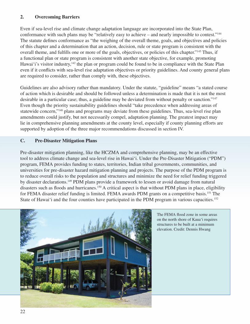
The FEMA flood zone in some areas on the north shore of Kaua‘i requires structures to be built at a minimum elevation. Credit: Dennis Hwang

Selected PDM Program Plans and Projects
Grant Title Date Federal Share Match
County of Kaua‘i – Development of New Wind Design Code Provisions and Risk Assessment Plan 8/12/2005 $135,000 $47,480
University of Hawai‘i System Multi-Hazard Mitigation Project 9/3/2005 $261,821 $87,275
Floodproofing of the Lower Hamakua Ditch, Island of Hawai‘i 9/29/2006 $2,999,943 $999,981
Critical Infrastructure Geographic Information System (GIS) Data Assessment 8/16/2007 $206,250 $68,750
Hawai‘i County All Hazard Assessment of Critical Facilities 8/16/2007 $255,000 $85,000
City and County of Honolulu Multi‐Hazard Pre‐Disaster Mitigation Plan Update 6/30/2008 $105,000 $35,000
County of Maui Multi-Hazard Mitigation Plan 7/11/2008 $300,000 $100,000
County of Hawai‘i Multi‐Hazard Mitigation Plan Update 7/11/2008 $361,448 $128,003
State of Hawai‘i Multi-Hazard Mitigation Plan Update 6/4/2010 $127,500 $42,500 Data from State of Hawai‘i Multi-Hazard Mitigation Plan 2010 Update.153
1. Recommendations and Next Steps
When updating and developing PDM plans and projects, state and county civil defense authorities should consider incorporating the 1-foot-by-2050 and 3-feet-by-2100 sea-level rise benchmark to better protect individuals and property from coastal hazards and disasters. Decision-makers could also seek FEMA funding to develop PDM projects for areas and infrastructure particularly vulnerable to amplified hazards resulting from sea-level rise and climate change.
The updated 2010 version of the County of Maui Multi-Hazard Mitigation Plan acknowledges sea-level rise as one of several contributors to long-term coastal erosion, which “threatens developed areas with potential loss of life and millions of dollars in property damage” to waterfront homes and public infrastructure.154 To mitigate these losses, the plan describes future initiatives for erosion rate mapping on the islands of Lana‘i and Moloka‘i and for requiring real estate disclosures for erosion hazard risks, dune nourishment, and beach maintenance.155 Adopting the plan qualifies Maui County for enhanced benefits under the NFIP, including discounts on insurance premiums and credits for public education and awareness, in addition to FEMA grants for pre-disaster and post-disaster assistance.156 The Maui County Office of Civil Defense is responsible for implementing the plan, which must be updated at least every five years. The Maui Island Plan advocates implementation of both the current hazard mitigation plan and future updates.157
2. Overcoming Barriers
Effective PDM plans and projects rely upon federal, state, and county cooperation and resources158 as well as best-available scientific data to support hazard and vulnerability assessments. Expanded sea-level rise research, as discussed in section IV.B, could provide relevant information for PDM planning and projects.
23

24
VI.VI. REGULATORY TOOLS
This Tool Kit next surveys a wide range of regulatory policies available to address climate change and sea-level rise. Like the preceding Planning Tools section, the tools are ranked based on impact and feasibility, with the highest ranking policy tools discussed first.
A. Zoning and Overlay Zones
Hawai‘i state law grants counties zoning authority and the authority to implement general plans.159 In the City and County of Honolulu, Maui County, and Hawai‘i County, zoning must conform to county plans (although Kaua‘i County plans do not constitute legal requirements for land use and development).160 The Hawai‘i Supreme Court has held that zoning “must bear a reasonable relation to, or be reasonably necessary for, the public health, safety, morals, or general welfare.”161 Zoning that is “clearly arbitrary and unreasonable, having no substantial relation to the public health, safety, morals, or general welfare” will be held invalid.162
Zoning ordinances vary among the counties to accommodate a range of needs, uses, development patterns, and characteristics distinctive to each island, region, and community. For example, in addition to establishing permitted uses, restrictions, and standards for development within designated zoning districts, the City and County of Honolulu’s Land Use Ordinance also requires special permits for development within seven special design districts, each of which is subject to specific controls.163 County codes also provide specifications and requirements for overlay zones, permitting, conditional zoning, conditional uses, variances, and nonconforming uses.164
1. Recommendations and Next Steps
Each county should consider adopting a zoning regime to facilitate sea-level rise adaptation. This zoning regime could feature overlay zones in areas vulnerable to sea-level rise, with the stated purpose of promoting public health and safety. Erosion rates tied to sea-level rise and erosion studies from the UH Coastal Geology Group could provide the data necessary to implement such zones. The zones could regulate armoring, density, retrofitting, relocation, and preservation to accommodate a variety of adaptation goals. In the Georgetown Climate Center’s Adaptation Tool Kit: Sea-Level Rise & Coastal Land Use – How Governments Can Use Land-Use Practices to Adapt to Sea-Level Rise (“Georgetown Tool Kit”), the author suggests four types of sea-level rise overlay zones:
• Protection zones. Areas with critical infrastructure and dense urban development, where the locality will permit coastal armoring. Local governments could require that non-structural hardening techniques be employed where feasible.
• Accommodation zones. Areas where local governments will limit the intensity and density of new development and require that structures be designed or retrofitted to be more resilient to flood impacts.
• Retreat zones. Areas where armoring will be prohibited and landowners are encouraged to relocate structures upland through tax incentives, land acquisitions, or conservation easement programs.
• Preservation zones. Areas where important ecosystems are designated for preservation and restoration to enhance important flood buffers, habitat, or public benefit.165

25
The County of Tillamook, Oregon, created a beach and sand dune overlay zone to implement a statewide goal, adopted in 1976, “[t]o conserve, protect, where appropriate develop, and where appropriate restore the resources and benefits of coastal beach and dune areas; and [t]o reduce the hazard to human life and property from natural or man-induced actions associated with these areas.”166 The ordinance categorizes areas located within the overlay zone into four groups: developed beachfront areas, foredune management areas, resource protection areas, and stabilized beach and dune areas. Varying degrees of conservation, protection, and restoration measures are permitted and restricted within each category.167 Permits may be obtained for protective structures only in developed beachfront areas and foredune management areas, and only if the structures qualify for an enumerated exception. In effect, the county has implemented a zoning ordinance that promotes adaptation while fulfilling a goal that was established before sea-level rise was contemplated.
Similarly, the Town of East Hampton, New York, created a coastal erosion overlay district to protect the natural shoreline and coastal resources from flooding and erosion. The district is divided into four erosion zones based upon similar features, characteristics, and storm exposures.168 Development, uses, and activities within the district are subject to restrictions and regulations that seek to minimize risk to human life and property as well as damage to natural buffers such as wetlands, beaches, bluffs, dunes, and vegetation.169 Permits for erosion control structures may be granted only in one particular zone, in which such structures are the only remaining protection from flooding and erosion.170 Additionally, the ordinance allows for certain emergency activities within the overlay district that are “immediately necessary to protect the public health, safety, or welfare, or to protect publicly or privately owned buildings and structures from major structural damage.”171
UH Sea Grant worked with South Maui
volunteers to build a new elevated dune
walkover in December 2010 at Maui’s
Kamaole III County Beach Park. Credit:
Tara Miller Owens, UH Sea Grant

26
2. Overcoming Barriers
Like similar measures, establishing sea-level rise overlay zones requires political will based on public education and outreach. Decision-makers will be challenged to develop general adaptation goals that at the same time accommodate unique circumstances, characteristics, and needs pertaining to specific areas and communities. A lead agency or task force, as discussed in section IV.C, could provide assessments and information to support this process. In some instances, landowners may seek variances and exemptions from sea-level rise overlay zones. New zoning ordinances should be drafted and enforced to ensure variances and exemptions are administered consistent with policy objectives.
B. Floodplain Regulations
The risk of increased flooding and coastal inundation from climate change and sea-level rise can be addressed by floodplain regulations. The Flood Insurance and Mitigation Administration (“FIMA”), a component of FEMA, administers the NFIP. The NFIP provides flood insurance, floodplain management, and flood mapping. To be eligible, local governments must adopt and enforce floodplain management ordinances that meet or exceed minimum NFIP criteria for regulating development in areas identified as special flood hazard areas (“SFHA”).172 SFHAs, commonly referred to as 100-year floodplains, are areas that have a 1% or greater chance of flooding in any given year.173 FIMA identifies boundaries and water surface elevations for SFHAs as well as 500-year floodplains on flood insurance rate maps (“FIRM”).174
All four counties in Hawai‘i participate in the NFIP to qualify homeowners for federally subsidized flood insurance. Each has adopted floodplain ordinances to comply with NFIP requirements. The ordinances list building standards and permitted uses for a variety of flood hazard districts that are indicated on each county's respective FIRM. The ordinances also include provisions for permitting, variances, and nonconforming uses.175
Homeowners can qualify for discounts on flood insurance premiums and credits under the NFIP Community Rating System (“CRS”) when counties adopt floodplain management regulations that are more stringent than NFIP minimum requirements. The CRS also provides credits for land acquisitions,
Inundaton at Keauhou Bay, Hawai‘i during the September 2009 tsunami. Credit: State of Hawai‘i Department of Land and Natural Resources
27
The zoning ordinance for the Town of Chatham, Massachusetts, prohibits new residential construction within the 100-year floodplain, permits other uses including agriculture, beach nourishment, recreation, and fishing, and requires special permits for uses such as marinas and boat launches.189
In a landmark 2005 ruling, the Massachusetts Supreme Judicial Court ruled that a zoning ordinance did not constitute a regulatory taking based on allegations that it prevented the plaintiff from constructing a home and may have reduced the property’s market value. The Court upheld the ordinance because it had the clear goal of protecting people and property, left the property owner with many alternative uses, and was applied fairly to identifiable, mapped areas.190
Wetland regulations for the Town of Falmouth, Massachusetts, require consideration and incorporation of sea-level rise for development within the 100-year floodplain. The purpose of these regulations is to protect portions of coastal floodplains located immediately landward of salt marshes, coastal dunes, and barrier beaches and to allow for their landward migration.191
1. Recommendations and Next Steps
The counties should consider amending floodplain regulations to achieve sea-level rise and climate change adaptation objectives. FIMA generates maps based upon historical data, a practice that assumes static climatic conditions.180 Because sea-level rise will increase the frequency and geographic extent of flooding caused by storm surge, and because Hawai‘i has been enduring more intense rainstorms due to climate change,181 county decision-makers could adjust floodplain ordinances to account for these increases and more effectively fulfill the purposes of the NFIP.182
The counties should also consider imposing use restrictions on development in areas most vulnerable to flooding.183 The City and County of Honolulu, for example, limits development in the flood hazard zone (the most hazardous area within the floodplain) to recreational, agricultural, and other non-residential uses.184 Kaua‘i County prohibits construction of schools, hospitals, nursing homes, and certain publicly-owned buildings within the tsunami inundation zone.185 The counties could expand use restrictions in high-hazard areas that limit projects involving residential development, public expenditures, and critical infrastructure.186
In addition, the counties could strengthen restrictions in districts beyond those currently identified as most hazardous by FIMA, such as the flood fringe, coastal high hazard areas,187 and the 500-year floodplain.188 This would accommodate more frequent and extensive flooding not yet accounted for in FIRMs. On a project-specific basis, the counties could require developers to consider or incorporate specified degrees of sea-level rise for projects located within the floodplain.
relocation, flood-proofing, open space preservation, and other measures that reduce flood damages.176 Hawai‘i County’s FIRM maps now incorporate results from the Hawaiian Islands Coastal Hurricane Study.177 These updated maps may eventually require thousands of additional landowners to purchase flood insurance and meet more costly construction standards.178 Because the county participates in the CRS, however, residents may qualify for discounted flood insurance.179

2. Overcoming Barriers
Applying more stringent floodplain regulations that incorporate updated sea-level rise projections may increase insurance and construction costs. To ensure support for such measures, counties should continue to participate in the CRS. More frequent FIRM map updates are necessary to effectively implement floodplain regulations. Generating federal capacity, resources, and political will to execute these upgrades may pose a significant barrier.192 Because FIMA utilizes contractors and state and local partners for mapping,193 decision-makers at all levels of government should share data and studies. Enhanced coordination will help ensure the best-available data is incorporated into future FIRM updates.
C. Shoreline Construction Setbacks Siting shoreline structures out of harm’s way, by means of setbacks, is fundamental to sea-level rise adaptation. Shoreline construction setbacks indicate the closest distance to the shoreline where development may be permitted. Hawai‘i law defines the shoreline as “the upper reaches of the wash of the waves . . . usually evidenced by the edge of vegetation growth, or the upper line of debris left by the wash of the waves.”194 Although under the HCZMA setbacks shall be not less than 20 feet and not more than 40 feet inland from the shoreline,195 all counties have adopted more stringent setbacks.196 Kaua‘i and Maui counties have adopted innovative shoreline erosion-based construction setbacks based upon data from the UH Coastal Geology Group.
In 2008, Kaua‘i County adopted what is considered one of the most protective shoreline construction setbacks in the nation. The setback line is the sum of 40 feet plus 70 years times the average annual erosion rate. Seventy years was derived from a Federal Insurance Administration Department of Housing and Urban Development engineering study determining the average life span of wood-framed coastal structures.197 The planning period for structures 5,000 square feet or greater is 100 years because they are often built using stone or more durable materials.198 Kaua‘i’s rules provide for a 10% adjustment in the average annual erosion rate for future sea-level rise in some cases,199 which encompasses principles of adaptive management and planning. Kaua‘i County also incorporated a minimum buildable footprint allowance of 1,500 square feet to avoid potential regulatory takings claims due to increased shoreline construction setbacks associated with the 2008 ordinance.
In Maui County, the shoreline setback line is the greater of the following two distances, (i) 25 feet plus 50 times the annual erosion rate, or (ii) 25 feet for lots with depths of 100 feet or less, 40 feet for lots with depths between 100 and 160 feet, or 25% of the lot depth for lots with depths greater than 160 feet, up to a maximum 150 feet.200
In the City and County of Honolulu, the shoreline setback is generally 40 feet inland from the certified shoreline but can be decreased to 20 feet for lots whose depth of buildable area is less than 30 feet.201 For new subdivisions, the setback is 60 feet.202
Hawai‘i County establishes the shoreline setback at a minimum of 40 feet. Exceptions apply to nonconforming lots that are less than 100 feet deep or have less than 50% buildable area remaining.203
28

29
1. Recommendations and Next Steps
At the state level, ICAP has suggested removing the maximum 40-foot setback limit to account for structures located in the state conservation district.204 At the county level, adopting erosion-based setbacks similar to Kaua‘i’s that account for the lifespan of structures and allow for sea-level rise adjustments could be an effective adaptation measure for restricting development where there are large areas of erodible shoreline. UH recently completed erosion studies for the City and County of Honolulu, which provide data necessary to amend setback regulations. The necessity for an erosion-based setback in Hawai‘i County is less clear given the island’s relatively less erodible basalt rock coastlines.
Under Maine’s Coastal Sand Dune Rules, setback calculations for structures greater than 2,500 feet must incorporate a 2-foot rise in sea level over the next 100 years.205
The 2009 California Climate Adaptation Strategy recommends that state and local jurisdictions collaborate to consider mandatory construction setbacks that prohibit construction and significant redevelopment in “areas that will likely be impacted by sea-level rise within the life of the structure.”206
2. Overcoming Barriers
O‘ahu and other islands have urban areas with shallow lot sizes that may give rise to regulatory takings claims if stringent setbacks are applied in a manner that precludes any construction. To avoid such lawsuits, counties could apply scaled setbacks to smaller parcels based upon average lot depth; Maui County and Hawai‘i County have taken this approach to ensure that parcels retain buildable space. More protective setback laws should withstand regulatory takings claims when enforcement is necessary to prevent property damage and reduce risks to public health and safety.207 County decision-makers could also consider requiring deed restrictions forbidding armoring or any other action interfering with natural coastal processes as a variance condition.
Coastal construction setback from the shoreline provides
an open beach area for public use at Kahala Beach, O‘ahu.
Credit: Dolan Eversole, NOAA Sea Grant Coastal
Storms Program Coordinator, Pacific Region

30
1. Recommendations and Next Steps
The Kailua Beach and Dune Management Plan recommends implementing CCCLs on Hawai‘i beaches undergoing accretion. For Kailua Beach specifically, the plan proposes:
• Establishing the CCCL at the seaward edge of all existing major structures;
• Periodically reviewing the CCCL based upon best-available erosion and sea-level rise data; and
• Relocating the CCCL when necessary.209
D. Coastal Construction Control Lines
Under current setback laws, building control lines fluctuate with shoreline changes. If accretion occurs, structures may be built farther seaward. These structures will then be more vulnerable to storm surge, future erosion, tsunamis, and related coastal hazards. CCCL programs address this concern. Unlike setbacks, CCCLs are fixed and pre-recorded lines that do not change based on accretion, thus halting incremental seaward movement of the building control line. Existing and future development seaward of the CCCL is regulated, although not necessarily prohibited.208
The Florida legislature established a CCCL Program as one of three components of the Florida Beach and Shore Preservation Act. The purpose of the program is to preserve and protect the state’s beaches and coastal barrier dunes, which are subject to severe and frequent fluctuations, from imprudent construction while allowing reasonable use of private property. The program acknowledges that such construction can jeopardize beach and dune system stability, accelerate erosion, provide inadequate protection to upland structures, endanger adjacent properties, and interfere with public beach access.
While exercising adaptive management and planning, the Florida Department of Environmental Protection establishes and periodically reviews and updates CCCLs for each coastal county containing sandy beaches. CCCLs define areas subject to severe fluctuations based upon the 100-year storm surge, storm waves, or other predictable weather conditions and are determined from comprehensive engineering studies and topographic surveys.210 Unlike setbacks, development seaward of the CCCL is not prohibited but is subject to special siting and design criteria as well as specific rules and permitting procedures.211
2. Overcoming Barriers
Hawai‘i state and local governments have utilized setback regimes under the HCZMA since the late 1980s. Outreach and education may be necessary to generate support for the relatively novel CCCL approach. Like similar measures, CCCLs must be reviewed and updated periodically to accommodate shoreline fluctuations. Thus, ongoing scientific studies regarding storm surge, sea-level rise, and erosion are necessary to ensure CCCLs are based on the best-available science. Expanded climate change and sea-level rise research, as discussed in section IV.B, would provide data in support of CCCL programs. In addition, CCCLs are most effective on dynamic shorelines that erode and accrete in cycles, especially accreting coastlines where it is advisable to limit or further control seaward development. CCCLs may be less effective absent these conditions.

31
The Legislature finds and declares that the beaches in this state and the coastal barrier dunes adjacent to such beaches, by their nature, are subject to frequent and severe fluctuations and represent one of the most valuable natural resources of Florida and that it is in the public interest to preserve and protect them from imprudent construction which can jeopardize the stability of the beach-dune system, accelerate erosion, provide inadequate protection to upland structures, endanger adjacent properties, or interfere with public beach access. In furtherance of these findings, it is the intent of the Legislature to provide that the department establish coastal construction control lines on a county basis along the sand beaches of the state fronting on the Atlantic Ocean, the Gulf of Mexico, or the Straits of Florida.
Florida Beach and Shore Preservation Act212
E. Hard Armoring Although seawalls and shoreline hardening are not favored under state law, they remain central to the discussion of sea-level rise adaptation. Under the HCZMA, hard armoring structures and devices in the shoreline area (i.e., the area between the shoreline and setback line) are prohibited unless the property owner qualifies for a statutory exemption or obtains a variance. (Variances are not required if the structure was completed prior to June 22, 1970, approved prior to June 16, 1989, or was located outside the shoreline area when approved.) Permitted structures may be repaired, but not enlarged, without a variance.213
County ordinances provide specific guidance for county permitting authorities to grant or deny permits for shoreline hard armoring structures.214 Variances also may be granted by county agencies under prescribed circumstances. Under state law, any variance must contain conditions that maintain shoreline access or compensate for its loss, minimize the risks of adverse impacts on the shoreline or structural failure on public property, and minimize adverse impacts on public views to, from, and along the shoreline.215
Disintegrating ad hoc erosion control structures placed in
front of homes in response to chronic
and seasonal erosion on the north shore of O‘ahu. Credit: Dolan Eversole, NOAA Sea Grant Coastal Storms Program Coordinator,
Pacific Region

Although the HCZMA establishes the legal framework for county regulation of shoreline hardening, the counties regulate land and all structures (including hardening structures) landward of the certified shoreline.216
Under section 23-1.8 of the Revised Ordinances of Honolulu, for example, the City and County of Honolulu may deny a property owner’s request for a variance to build a shoreline hardening structure unless the structure is minor and does not interfere significantly with natural processes. The County must “protect and preserve the natural shoreline, especially sandy beaches.”217
Maui County similarly prohibits shoreline hardening structures or activities, unless they are necessary for beach or dune nourishment activities and landscape planting and irrigation purposes. The Maui Planning Commission may grant a variance to a property owner regarding a legal habitable structure or public infrastructure, however, as long as the structure at risk of damage from coastal erosion poses a danger to the health, safety and welfare of the public, and the proposed hardening is the best shoreline management option in accordance with relevant state policy on shoreline hardening.
In 2009, Chapter 8 of the Kaua‘i County Code was amended and section 8-27.7 now states that the “construction of any erosion-control or shoreline hardening structure or activity shall not to be allowed to protect the permitted structure or activity during its life, with the exception of approved beach or dune nourishment fill activities, and landscape planting and irrigation.” Section 8-27.7 was further amended to include the following language: “All new structures or activities shall not (i) adversely affect beach processes, (ii) artificially fix the shoreline, (iii) interfere with public access or public views to and along the shoreline, (iv) impede the natural processes and/or movement of the shoreline and/or sand dunes, or (v) alter the grade of the shoreline setback area . . . All new structures shall be consistent with the purposes of this article and HRS Chapter 205A, as amended.”
32
Regional armoring due to long-term chronic erosion has resulted in the loss of sandy beach in Lanikai, O‘ahu. Credit: UH Sea Grant
33
Finally, Hawai‘i County is unlikely to permit property owners to build a structure related to shoreline hardening within the shoreline area unless the following applies: a permitted structure through issuance of variance from the Planning Commission; completed by or activities which commenced prior to June 22, 1970; a structure or activity that has received a building permit, DLNR approval, Special Management Area Use Permit/approval and/or a shoreline setback variance prior to June 16, 1989; structures and activities necessary for or ancillary to continuation of existing agriculture or aquaculture activity in the shoreline setback area prior to June 16, 1989; or work being done consists of maintenance, repair, reconstruction, and minor additions to or alterations of legal, publicly-owned boating, maritime, or water sports recreational facilities, which result in little or no interference with natural shoreline processes.
Shoreline protection is most effective and less damaging to natural resources if it is the appropriate kind of structure for the project site and erosion and flood problem, and is properly designed, constructed, and maintained. Because factors affecting erosion and flooding vary considerably, no single protective method or structure is appropriate in all situations. When a structure is not appropriate or is improperly designed and constructed to meet the unique site characteristics, flood conditions, and erosional forces at the project site, the structure is more likely to fail, require additional fill to repair, have higher long-term maintenance costs because of higher frequency of repair, and cause greater disturbance and displacement of the site’s natural resources. San Francisco Bay Conservation and Development Commission218
1. Recommendations and Next Steps
It is recommended that variances require hard armoring structures to be capable of withstanding coastal hazards under the 1-foot-by-2050 and 3-feet-by-2100 benchmark. Counties also should consider imposing development restrictions that discourage hard armoring. Shoreline structure variances must be conditioned to “minimize risk of adverse impacts on beach processes,”219 and shoreline hardening can cause beach loss and may interfere with natural accretion. Variances could similarly be conditioned to prohibit future repairs and to not allow property owners to seek variances or permits to expand or strengthen such structures in the future. County ordinances also could require property owners to consider relocation of residences and non-structural or soft-armoring protection methods before hard armoring structures may be approved. In addition, state and local governments could adopt policies generally favoring non-structural armoring over hard armoring as a shoreline protection measure. Finally, under severe conditions, hard armoring structures themselves may fail and create a debris hazard. Variances must therefore be conditioned to “minimize risk of structures failing and becoming loose rocks or rubble on public property.”220

Under the San Francisco Bay Plan’s amended shoreline protection policies, new shoreline protection projects, as well as the maintenance or reconstruction of existing projects, should be authorized if:
- The project is necessary to provide flood or erosion protection for existing development, use, or infrastructure, or is consistent with other Bay Plan policies;
- The type of the protective structure is appropriate for the project site, the uses to be protected, and the erosion and flooding conditions at the site;
- The project is properly engineered to provide erosion control and flood protection for the expected life of the project based on a 100-year flood event that takes future sea level rise into account;
- The project is properly designed and constructed to prevent significant impediments to physical and visual public access; and
- The protection is integrated with current or planned adjacent shoreline protection measures.
Furthermore, authorized shoreline protection projects should include long-term maintenance programs to protect the shoreline from erosion and minimize effects on natural resources. Non-structural methods such as marsh vegetation should be considered where feasible and appropriate.221
Under the Rhode Island Coastal Resources Management Program, state law requires property owners to exhaust all reasonable alternatives, including relocation and non-structural shoreline protection methods, before proposing structural shoreline protection.222
In South Carolina, after June 30, 2005, seawalls and bulkheads may not be repaired or replaced if damaged more than 50%. The damage percentage necessary for prohibiting repairs and replacement is higher for older structures.223 Additionally, the South Carolina Coastal Council is prohibited from permitting new seawalls or erosion control devices within the setback zone under any circumstances in order to limit the nature of development within the setback area.224
As a condition for approving shoreline protection structures, repairs, or additions, the Coastal Zone Shoreline and Bluff Ordinance of Malibu, California, requires deed restrictions in which the property owner acknowledges that no future repairs, maintenance, enhancement, reinforcement, or extensions shall be undertaken and expressly waives his or her rights to such activities. The deed restrictions also require the property owner to acknowledge that the structure is intended to protect only existing structures in their present condition and location.225
34
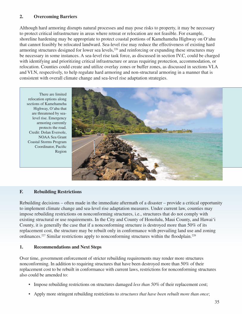
35
2. Overcoming Barriers
Although hard armoring disrupts natural processes and may pose risks to property, it may be necessary to protect critical infrastructure in areas where retreat or relocation are not feasible. For example, shoreline hardening may be appropriate to protect coastal portions of Kamehameha Highway on O‘ahu that cannot feasibly be relocated landward. Sea-level rise may reduce the effectiveness of existing hard armoring structures designed for lower sea levels,226 and reinforcing or expanding these structures may be necessary in some instances. A sea-level rise task force, as discussed in section IV.C, could be charged with identifying and prioritizing critical infrastructure or areas requiring protection, accommodation, or relocation. Counties could create and utilize overlay zones or buffer zones, as discussed in sections VI.A and VI.N, respectively, to help regulate hard armoring and non-structural armoring in a manner that is consistent with overall climate change and sea-level rise adaptation strategies.
1. Recommendations and Next Steps
Over time, government enforcement of stricter rebuilding requirements may render more structures nonconforming. In addition to requiring structures that have been destroyed more than 50% of their replacement cost to be rebuilt in conformance with current laws, restrictions for nonconforming structures also could be amended to:
• Impose rebuilding restrictions on structures damaged less than 50% of their replacement cost;
• Apply more stringent rebuilding restrictions to structures that have been rebuilt more than once;
F. Rebuilding Restrictions
Rebuilding decisions – often made in the immediate aftermath of a disaster – provide a critical opportunity to implement climate change and sea-level rise adaptation measures. Under current law, counties may impose rebuilding restrictions on nonconforming structures, i.e., structures that do not comply with existing structural or use requirements. In the City and County of Honolulu, Maui County, and Hawai‘i County, it is generally the case that if a nonconforming structure is destroyed more than 50% of its replacement cost, the structure may be rebuilt only in conformance with prevailing land use and zoning ordinances.227 Similar restrictions apply to nonconforming structures within the floodplain.228
There are limited relocation options along
sections of Kamehameha Highway, O‘ahu that
are threatened by sea-level rise. Emergency
armoring currently protects the road.
Credit: Dolan Eversole, NOAA Sea Grant
Coastal Storms Program Coordinator, Pacific
Region
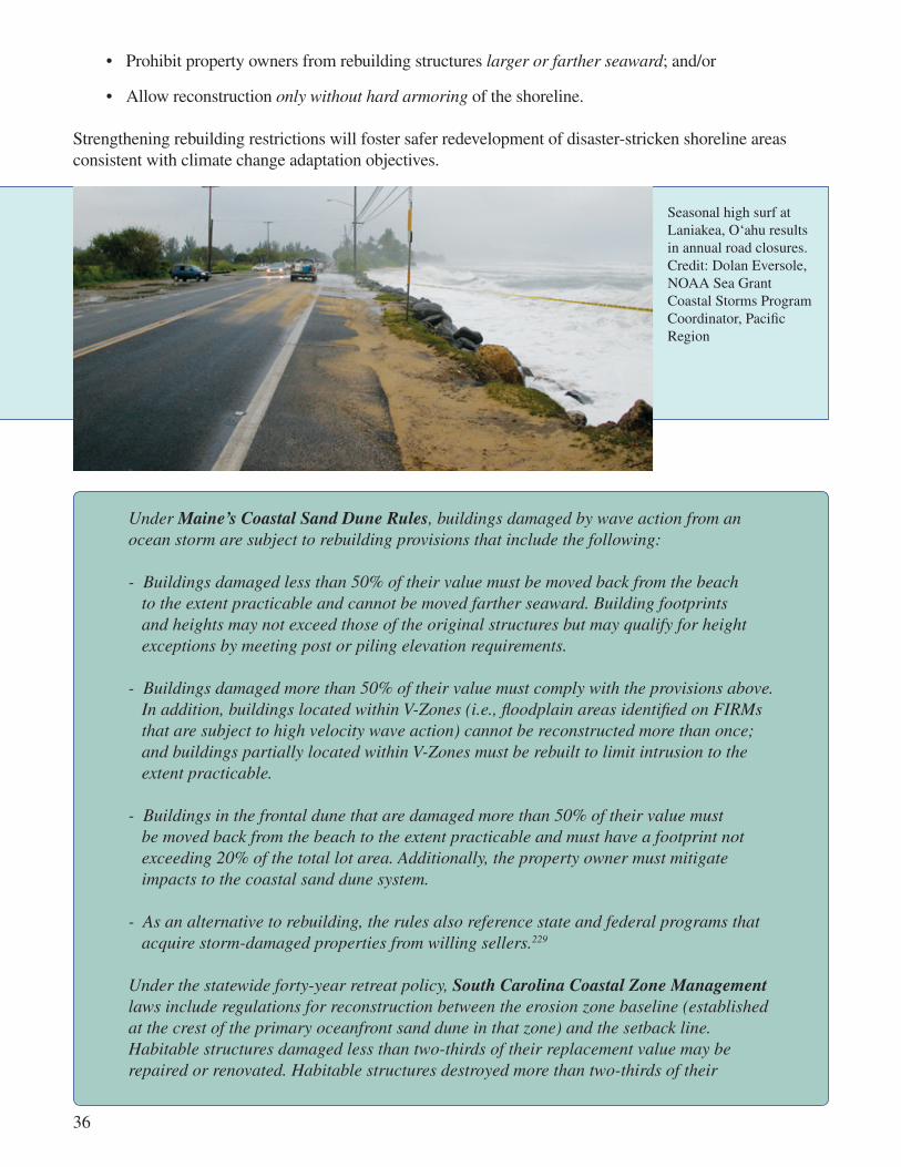
Under Maine’s Coastal Sand Dune Rules, buildings damaged by wave action from an ocean storm are subject to rebuilding provisions that include the following:
- Buildings damaged less than 50% of their value must be moved back from the beach to the extent practicable and cannot be moved farther seaward. Building footprints and heights may not exceed those of the original structures but may qualify for height exceptions by meeting post or piling elevation requirements.
- Buildings damaged more than 50% of their value must comply with the provisions above. In addition, buildings located within V-Zones (i.e., floodplain areas identified on FIRMs that are subject to high velocity wave action) cannot be reconstructed more than once; and buildings partially located within V-Zones must be rebuilt to limit intrusion to the extent practicable.
- Buildings in the frontal dune that are damaged more than 50% of their value must be moved back from the beach to the extent practicable and must have a footprint not exceeding 20% of the total lot area. Additionally, the property owner must mitigate impacts to the coastal sand dune system.
- As an alternative to rebuilding, the rules also reference state and federal programs that acquire storm-damaged properties from willing sellers.229
Under the statewide forty-year retreat policy, South Carolina Coastal Zone Management laws include regulations for reconstruction between the erosion zone baseline (established at the crest of the primary oceanfront sand dune in that zone) and the setback line. Habitable structures damaged less than two-thirds of their replacement value may be repaired or renovated. Habitable structures destroyed more than two-thirds of their
36
• Prohibit property owners from rebuilding structures larger or farther seaward; and/or
• Allow reconstruction only without hard armoring of the shoreline.
Strengthening rebuilding restrictions will foster safer redevelopment of disaster-stricken shoreline areas consistent with climate change adaptation objectives.
Seasonal high surf at Laniakea, O‘ahu results in annual road closures. Credit: Dolan Eversole, NOAA Sea Grant Coastal Storms Program Coordinator, Pacific Region

37
replacement value, however, may be replaced only if the replacement structure does not extend farther seaward of the setback line than the original and is moved landward of the setback line where possible, or as far landward as practicable. The law also includes rebuilding restrictions for erosion control structures and devices that vary according to the extent damaged and the age of the structure. If the structure is damaged less than a certain percentage, it may be maintained in its present condition but cannot be enlarged, strengthened, rebuilt, or repaired with different materials. If the structure is damaged more than the prescribed percentage, it must be removed unless it is protecting a public highway.230
2. Overcoming Barriers
Rebuilding restrictions affect property use only after natural disasters and thus are not proactive tools.231 In densely developed coastal areas with smaller lot sizes, tighter rebuilding restrictions run the risk of preventing use of the lot, thus triggering regulatory takings claims. In many instances, property owners may be expected to seek variances to allow them to essentially replace damaged structures. To promote the success of adaptation through rebuilding restrictions, decision-makers should consider pairing such measures with spending and market-based tools, as discussed in sections VII and VIII, which may promote increased support among affected landowners.
G. Building Codes and Resilient Design
The Hawai‘i Legislature established the State Building Code Council in 2007 pursuant to Act 82. Act 82232 charged the council with establishing a comprehensive state building code,233 which must include the latest editions of the state fire code, the Uniform Plumbing Code, and the International Building Code in addition to other nationally published codes and standards for safety and energy conservation. The code must also include design standards for emergency shelters capable of withstanding a 500-year hurricane and for essential government facilities.234 Counties are responsible for adopting a building code ordinance based upon the state model, with amendments that may be stricter but not more lenient than the state model.235 The Hawai‘i Legislature adopted and approved the current state building code in April 2010.236
The counties have also adopted ordinances to meet NFIP resilient design requirements for development within the floodplain to be eligible for federal flood insurance.237 NFIP regulations include requirements concerning ground-floor elevation, flood-proofing, anchoring, and building materials.238
1. Recommendations and Next Steps
The State Building Council could be directed to amend the state building code to incorporate the 1-foot-by-2050 and 3-feet-by-2100 sea-level rise benchmark, with counties adopting potentially more restrictive amendments. The counties also could adopt ordinances that expand NFIP resilient design regulations by:
• Raising elevation requirements;239
• Applying resilient design requirements to districts beyond those identified as most hazardous by FEMA, such as the flood fringe, coastal high hazard areas,240 and the 500-year floodplain;241 and/or
• Applying resilient design requirements to all structures undergoing improvements and repairs, rather than to newly proposed structures only.242

In 2007, the Rhode Island legislature adopted a statute requiring the state building code standards committee, in consultation with the building code commissioner, to take into account, to the extent reasonable and feasible, “climatic changes and potential climatic changes and sea level rise” when adopting, amending, and repealing code provisions.243
2. Overcoming Barriers
Building codes and resilient design requirements, whether at the state or county level, require regular reviews and updates based upon new information to provide the best protection from coastal hazards.244 Effective implementation and enforcement also require ongoing training of enforcement personnel and educating the building community and property owners. The state could lead these efforts to ensure coordination.245 FEMA maintains guidance for construction of buildings in coastal high hazard areas, which could provide a resource for further amending building codes and resilient design requirements.246
H. Subdivision Approvals
County subdivision ordinances regulate land use by providing processes, rules, and conditions for dividing large tracts of land into smaller parcels for development. In Hawai‘i, subdivisions generally must comply or be consistent with state and local plans, laws, rules, and regulations.247
1. Recommendations and Next Steps
County decision-makers can utilize their existing authority to protect subdivision residents from future coastal hazards.248 To further incorporate sea-level rise adaptation in the subdivision process, county ordinances could require hazard assessments at the subdivision stage. Subdivision proposals that require shoreline protection, cause erosion, or become subject to specified degrees of inundation could be rejected.
The director of the Hawai‘i County Planning Department implemented sea-level rise adaptation measures at the subdivision phase in Kapoho, an area prone to monthly flooding, by requiring a proposed subdivision to be above water in 100 years after 3 to 4 feet of continuous land subsidence, 2 feet of subsidence from a catastrophic event, and 2 feet of future sea-level rise.249 The county subdivision ordinance authorizes such measures by stating, “[a] lot shall be suitable for the purposes for which it is intended to be sold. No area subject to periodic inundation which endangers the health or safety of its occupants may be subdivided for residential purposes.”250
The City of Malibu, California, explicitly requires developers to account for anticipated future changes in sea level and potential impacts on beach erosion, shoreline retreat, and bluff erosion rates in the siting and design of shoreline development to eliminate or minimize associated hazards.251 The city’s subdivision ordinance, adopted under the Malibu Local Coastal Program, prohibits new beachfront or blufftop subdivisions unless the lots can be developed without requiring a bluff or shoreline protection structure within the full 100-year economic life of the development.252
38
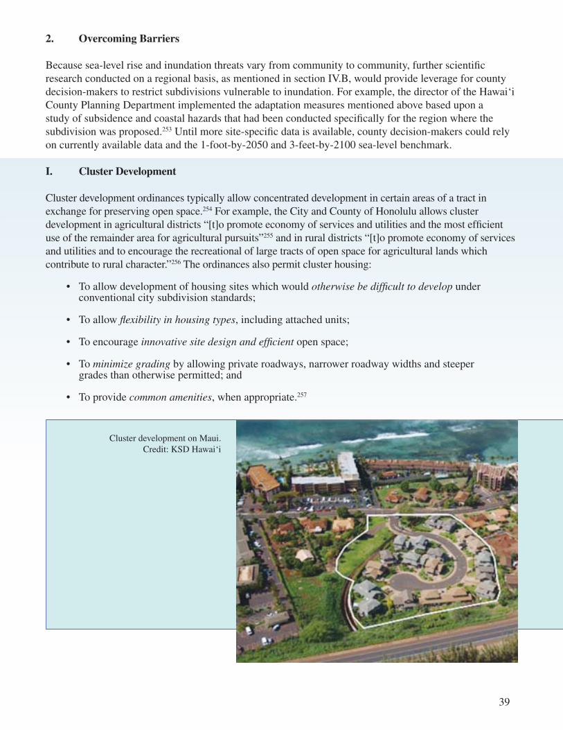
2. Overcoming Barriers
Because sea-level rise and inundation threats vary from community to community, further scientific research conducted on a regional basis, as mentioned in section IV.B, would provide leverage for county decision-makers to restrict subdivisions vulnerable to inundation. For example, the director of the Hawai‘i County Planning Department implemented the adaptation measures mentioned above based upon a study of subsidence and coastal hazards that had been conducted specifically for the region where the subdivision was proposed.253 Until more site-specific data is available, county decision-makers could rely on currently available data and the 1-foot-by-2050 and 3-feet-by-2100 sea-level benchmark.
I. Cluster Development
Cluster development ordinances typically allow concentrated development in certain areas of a tract in exchange for preserving open space.254 For example, the City and County of Honolulu allows cluster development in agricultural districts “[t]o promote economy of services and utilities and the most efficient use of the remainder area for agricultural pursuits”255 and in rural districts “[t]o promote economy of services and utilities and to encourage the recreational of large tracts of open space for agricultural lands which contribute to rural character.”256 The ordinances also permit cluster housing:
• To allow development of housing sites which would otherwise be difficult to develop under conventional city subdivision standards;
• To allow flexibility in housing types, including attached units;
• To encourage innovative site design and efficient open space;
• To minimize grading by allowing private roadways, narrower roadway widths and steeper grades than otherwise permitted; and
• To provide common amenities, when appropriate.257
39
Cluster development on Maui. Credit: KSD Hawai‘i
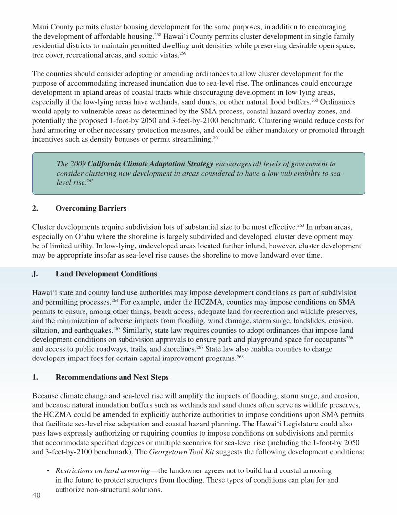
Maui County permits cluster housing development for the same purposes, in addition to encouraging the development of affordable housing.258 Hawai‘i County permits cluster development in single-family residential districts to maintain permitted dwelling unit densities while preserving desirable open space, tree cover, recreational areas, and scenic vistas.259
The counties should consider adopting or amending ordinances to allow cluster development for the purpose of accommodating increased inundation due to sea-level rise. The ordinances could encourage development in upland areas of coastal tracts while discouraging development in low-lying areas, especially if the low-lying areas have wetlands, sand dunes, or other natural flood buffers.260 Ordinances would apply to vulnerable areas as determined by the SMA process, coastal hazard overlay zones, and potentially the proposed 1-foot-by 2050 and 3-feet-by-2100 benchmark. Clustering would reduce costs for hard armoring or other necessary protection measures, and could be either mandatory or promoted through incentives such as density bonuses or permit streamlining.261
The 2009 California Climate Adaptation Strategy encourages all levels of government to consider clustering new development in areas considered to have a low vulnerability to sea-level rise.262
2. Overcoming Barriers
Cluster developments require subdivision lots of substantial size to be most effective.263 In urban areas, especially on O‘ahu where the shoreline is largely subdivided and developed, cluster development may be of limited utility. In low-lying, undeveloped areas located further inland, however, cluster development may be appropriate insofar as sea-level rise causes the shoreline to move landward over time.
J. Land Development Conditions
Hawai‘i state and county land use authorities may impose development conditions as part of subdivision and permitting processes.264 For example, under the HCZMA, counties may impose conditions on SMA permits to ensure, among other things, beach access, adequate land for recreation and wildlife preserves, and the minimization of adverse impacts from flooding, wind damage, storm surge, landslides, erosion, siltation, and earthquakes.265 Similarly, state law requires counties to adopt ordinances that impose land development conditions on subdivision approvals to ensure park and playground space for occupants266 and access to public roadways, trails, and shorelines.267 State law also enables counties to charge developers impact fees for certain capital improvement programs.268
1. Recommendations and Next Steps
Because climate change and sea-level rise will amplify the impacts of flooding, storm surge, and erosion, and because natural inundation buffers such as wetlands and sand dunes often serve as wildlife preserves, the HCZMA could be amended to explicitly authorize authorities to impose conditions upon SMA permits that facilitate sea-level rise adaptation and coastal hazard planning. The Hawai‘i Legislature could also pass laws expressly authorizing or requiring counties to impose conditions on subdivisions and permits that accommodate specified degrees or multiple scenarios for sea-level rise (including the 1-foot-by 2050 and 3-feet-by-2100 benchmark). The Georgetown Tool Kit suggests the following development conditions:
• Restrictions on hard armoring—the landowner agrees not to build hard coastal armoring in the future to protect structures from flooding. These types of conditions can plan for and authorize non-structural solutions.
40
• Removal requirements—the landowner agrees to remove structures when the shoreline recedes landward such that his or her structure encroaches on public lands. As the seas rise, the boundary between private lands and public beaches (the shoreline) will be pushed inland. This type of condition allows landowners to develop property but with the expectation that the development will eventually cede to rising seas.
• Dedications—the landowner dedicates an easement to preserve natural buffers, floodways, or to provide public access. Dedications may be subject to heightened judicial scrutiny.
• Impact fees—the developer is required to pay a fee to cover the costs of potential emergency response, flood-proofing infrastructure servicing the new development, future armoring, or mitigating impacts to natural resources from future armoring.
• Flood-proofing requirements—developers must design the new development and its supporting infrastructure to be more resilient to flood impacts. For example, permits could require that roads be elevated and that sewer lines be flood-proofed.269
The Hawaii Coastal Hazard Mitigation Guidebook recommends requiring landowners to dedicate a buffer zone, or “Beach Reserve,” to the counties as a condition for coastal subdivision approvals. The Guidebook also suggests achieving this dedication through development agreements,270 which pose less risk of a regulatory taking.
The California Coastal Commission imposes permit conditions that prohibit future armoring, require removal under certain circumstances, waive risk liability, and apply deed restrictions for development within the coastal zone. These conditions have not been tested in court, but the public trust doctrine should be considered a defense for past and future permit conditions prohibiting seawalls.271
41
2. Overcoming Barriers
Like other land use conditions, development restrictions to achieve sea-level rise adaptation objectives should be designed to withstand legal challenges. For example, the U.S. Supreme Court has held such conditions must promote a legitimate state interest, have a rational or essential nexus with the development project, and be proportional to the need or problem caused by the development project.272 State and local government authorities must ensure development restrictions are implemented consistent with this basic guidance.
K. Environmental Review
Under the Hawaii Environmental Policy Act, codified in Chapter 343 of the Hawaii Revised Statutes (“Chapter 343”), government actions and many private development projects must undergo an environmental review process. The purpose of the Chapter 343 environmental review process is to integrate the review of environmental concerns with existing state and county planning processes and alert decision-makers to significant environmental effects of certain actions. Environmental concerns are to be given appropriate consideration in decision-making along with economic and technical considerations.273

Major features of the process include preparation of an Environmental Assessment (“EA”) and Environmental Impact Statement (“EIS”).274 EAs may be triggered by the use of state or county land or funds and activities in state conservation district lands, shoreline areas, and in Waikïkï. If the agency determines that the proposed action “may have a significant effect on the environment,” based upon significance criteria found in administrative rules implementing Chapter 343, an EIS must be prepared to further disclose the environmental, economic, social, and cultural effects of proposed actions.275 The EIS also must propose measures to minimize adverse effects and offer alternatives.276 An agency or designated authority must accept the final EIS before a proposed action may commence or resume.277
1. Recommendations and Next Steps
The Chapter 343 significance criteria – which are used to determine whether a full EIS is required – could be amended to require an EIS when the proposed action increases “the scope or intensity of natural hazards to the public, such as increased coastal inundation, flooding, or erosion that may occur as a result of climate change anticipated during the life-time of the project.”278 Amending the Chapter 343 significance criteria in this manner would advance sea-level rise adaptation efforts statewide.
To further support adaptation, the Hawai‘i Legislature could amend Chapter 343 and its implementing administrative rules to require review of a project’s climate change impacts, particularly with regard to GHG emissions. In 2008, legislation was introduced to mandate that Chapter 343 address climate change279 by requiring an EIS to disclose the “effects of a proposed action as a contributor to climate change.”280 The legislation also sought to amend the definition of “significant effect” under Chapter 343 to include consideration of actions that “impact climate change.”281 The bill cited a decision by the United States Court of Appeals for the Ninth Circuit, which held for the first time that federal agencies must assess carbon dioxide emissions and other climate change impacts in environmental review documents prepared under the National Environmental Policy Act.282
Massachusetts environmental protection laws require relevant state and county authorities to consider “reasonably foreseeable climate change impacts, including additional greenhouse gas emissions, and effects, such as predicted sea level rise” when considering and issuing permits, licenses, and other administrative approvals. This requirement applies to the state’s environmental review process. The statute defines “damage to the environment” to include “[A]ny destruction, damage or impairment, actual or probable, to any of the natural resources of the commonwealth [including] . . . destruction of seashores, dunes, marine resources, underwater archaeological resources, [and] wetlands[.]”283
California’s Attorney General has interpreted the California Environmental Quality Act’s broad definition of “significant environmental effect” to require the consideration of climate change in environmental review documents.284 In August 2007 King County, Washington became the first in the nation to order county agencies to consider climate change impacts as part of their project review under Washington’s State Environmental Policy Act (“SEPA”).285 In support of its order, King County cited the 2007 United States Supreme Court decision in Massachusetts v. EPA, in which the Court determined that GHGs are an “air pollutant.”286 And in December 2007, Seattle, Washington adopted an ordinance that requires developers to quantify GHG emissions for all projects subject to the city’s environmental review and permitting process under SEPA.287
42
2. Overcoming Barriers
In the decades since its inception, the Chapter 343 environmental review process has played an important role in addressing a range of environmental and economic development issues in Hawai‘i. Given Chapter 343’s well-established ability to affect decision-making and outcomes, there may be resistance to incorporating climate change impacts into the process. The value and necessity of hazard mitigation and protecting Hawai‘i’s tourism infrastructure could be emphasized in support of amending Chapter 343 to explicitly incorporate climate change, consistent with Hawai‘i’s national leadership in environmental review.
L. Rolling Easement Statutes
The term rolling easements refers to a combination of land use policies that allow beaches and wetlands to migrate landward, restrict hard armoring, and promote removal of structures and general retreat.288 Rolling easements may avoid the costs and hazards of protecting lowlands from rising seas.289 State and local governments can establish easements through regulations (i.e., statutes, zoning ordinances, coastal or wetland regulations, or permit conditions290) or by transferring rights291 from property owners to public or private organizations not interested in hardening the shoreline.292
43
Rolling easement statutes are broadly effective because they apply to all identified coastal development rather than to specific parcels, as is the case with conservation easements and land development conditions.293 Rolling easement statutes typically:
• Prohibit shoreline hard armoring;
• Establish a rolling design boundary, seaward of which the owner’s property rights are reduced;
• Prohibit new structures seaward of the rolling design boundary;
• Encourage or require removal of existing structures when erosion leaves them seaward of the rolling design boundary;
• Warn prospective buyers of the regulations;
• Provide provisions for public access; and
• Indicate whether beach renourishment or adding sand dunes are permitted.294
1. Recommendations and Next Steps The state could consider adopting rolling easement policies under the HCZMA that collectively facilitate managed retreat from the shoreline. Developing a rolling easement program would require policymakers to establish clear sea-level rise adaptation goals and priorities, determine rolling boundaries for regulating development, amend existing state laws and ordinances to conform to these policies, and make decisions based upon best-available sea-level rise data.
The Texas legislature enacted the Texas Open Beaches Act to ensure free and unrestricted access295 to state-owned beaches, which include areas between the mean low tide line (seaward boundary) and the vegetation line (landward boundary) bordering the Gulf of Mexico.296 Because the statutes include provisions that allow public access

to “roll” landward as the vegetation line migrates landward, the laws came to be recognized as rolling easement statutes.297 The statutes prohibit construction or erection of barriers or restraints that would interfere with public access.298 When pre-existing shoreline protection structures prevent the vegetation line from migrating landward, the public acquires an easement for access along the structure’s entire landward edge.299 The state may order removal of structures that come to infringe upon public beach access or constitute an imminent hazard to public safety, health, or welfare. The state may contract for and publically fund removal.300 If a storm event causes the vegetation line to shift landward of a pre-existing house, the state may allow the house to remain for two years if it does not pose an imminent threat to public health and safety. This exception, however, does not apply to houses located below the mean high tide line or that have been destroyed by more than 50%.301 For the sale of certain coastal properties, the law requires real estate disclosures notifying potential buyers that the properties may come to be located on the public beach because of coastal erosion and storm events and that the state may require removal at the owner’s expense, among other provisions.302
The South Carolina Beachfront Management Act promotes the landward migration of beaches and sand dunes by establishing a forty-year retreat policy for adapting to erosion caused by sea-level rise, including rebuilding, removal, and relocation requirements, prohibiting shoreline hard armoring, creating an erosion-based setback, and requiring real estate disclosure of erosion rates.
The Rhode Island Coastal Resources Management Program allows for the landward migration of coastal resources by establishing policies that consider sea-level rise (section V.A), requiring buffer zones around coastal resources (section VI.N), and stating preferences for relocation over hard armoring (section VI.E).
Similarly, the Maine Coastal Zone Management Act and Coastal Sand Dune Rules allow for the landward migration of sand dunes303 through policies, development restrictions based upon erosion and sea-level rise projections, and requirements for rebuilding, relocation, and removal (section VI.F).
2. Overcoming Barriers
Rolling easements and managed retreat are innovative policies for implementing sea-level rise and climate change adaptation. Further research is necessary to evaluate how rolling easements may interact with existing coastal governance structures.304 M. Non-Structural Armoring
Non-structural armoring involves replenishing or mimicking natural buffers. It may also involve elevating land so that structures are less vulnerable to inundation. Examples include beach renourishment, dune creation and preservation, and wetland construction and restoration.305 DLNR regulates beach renourishment projects306 and state, county, and non-governmental organizations collaborate to fund, coordinate, and implement dune and wetland restoration projects.307
44

To preserve and restore primary coastal dunes in Kailua, O‘ahu the Kailua Beach and Dune Management Plan (“Kailua Plan”) proposes the following recommendations:
- Use signs, fencing, and movable dune walkovers at public beach access points to provide pedestrian access while preserving dune vegetation;
- Amend statutes and City and County of Honolulu ordinances to prohibit the grading of dunes in the shoreline setback area, require dune delineation for grading permits for coastal properties, recover beach-quality sand excavated during construction projects for dune restoration projects, and specify that any fill used in the setback area must be beach-quality sand;
- Encourage and support dune restoration efforts (dune fencing, re-vegetation, sand nourishment, etc.) with incentives such as grants or a conservation easement program managed by a non-profit land trust to manage the dune system and provide participating private landowners with tax relief or credits;
- Conduct additional studies and remediation or monitoring programs, as necessary, to obtain approval from the Hawaii Department of Health Clean Water Branch to allow the beneficial use of dredged sand from periodic dredging of the mouth of Ka‘elepulu Stream to replenish the beach fronting Kailua Beach Park; and
- Publish a handbook detailing the method and practice for future dune restoration projects.308
45
1. Recommendations and Next Steps
State and local governments should consider prioritizing non-structural armoring over hard armoring. County ordinances could require property owners to consider non-structural armoring before hard armoring variances are granted. Beach and dune renourishment efforts on private property could be incentivized.
Dune restoration at Kamaole II County Beach Park, Maui. Stabilizing the
coastal dunes provides a natural buffer to coastal hazards including sea-level rise.
Credit: UH Sea Grant
The Florida Beach and Shore Preservation Act allows for publicly funded renourishment of “critically eroded” beaches. The statutes specify that the state will not fund projects that “provide only recreational benefits.”309
The Malibu Local Coastal Program mandates “[o]n any beach found to be appropriate, alternative ‘soft solutions’ to the placement of shoreline protection structures shall be required to protect new or existing development. Soft solutions shall include dune restoration, sand nourishment, and design criteria emphasizing maximum landward setbacks and raised foundations.310
In Maryland, riparian landowners may use only non-structural shoreline stabilization methods to protect their property from erosion unless the Department of Natural Resources has designated and mapped the area as appropriate for structural stabilization or if non-structural methods are not feasible, such as in “areas of excessive erosion, areas subject to heavy tides, and areas too narrow for effective use of nonstructural shoreline stabilization measures.”311
2. Overcoming Barriers
Beach renourishment programs have been criticized for causing ecological harm due to sand collection and for promoting a temporary rather than long-term solution to coastal erosion problems.312 Renourishment also requires maintenance to sustain flood control benefits,313 and the cost of renourishment can often exceed that of hard armoring. As sea-level rise accelerates, however, and without improved coastal engineering structures, Waikïkï beach and other beaches will likely require more frequent renourishment. Although costly, coastal hazard concerns and economic factors may continue to lend support to beach renourishment and other forms of non-structural hardening.
N. Buffer Zones
Buffer zones can restrict development within specified distances of natural and cultural resources. For example, Hawai‘i law requires buffer zones to protect artesian water aquifers314 and archaeological sites.315 Establishing buffer zones around sand dunes and coastal wetlands could allow them to migrate landward with rising sea levels.316 In addition to naturally absorbing the impacts of flooding and inundation,317 wetlands and sand dunes provide scenic and recreational amenities while functioning as important natural habitats. Wetlands also provide water filtration benefits.318
1. Recommendations and Next Steps
The Hawai‘i Legislature should consider enacting laws that enable the counties to establish buffer zones to protect wetlands and sand dunes. Creating buffer zones would require identifying and mapping wetland and sand dune areas for protection, establishing buffer distances for prohibiting development around each area, and updating maps and buffer distances periodically to account for migration and expansion, erosion rate changes, and sea-level rise.
46

2. Overcoming Barriers
Mandating buffer zones could trigger regulatory takings claims, particularly if owners are deprived of all economically beneficial use of the property.322 Decision-makers could develop buffer zone regulations that vary depending on lot size and that allow for exceptions to better withstand legal challenges.
47
The Town of Barnstable, Massachusetts, established a 50-foot, undisturbed buffer zone for wetland resource areas to more effectively buffer, store, and contain increasing floodwaters resulting from sea-level rise. The regulation also authorizes the state conservation commission to permit certain activities and uses, such as access paths within the buffer zone, on a discretionary basis.319
The Rhode Island Coastal Resources Management Program establishes coastal buffer zones based upon the legislative mandate “to preserve, protect and, where possible, restore ecological systems.” The program requires property owners to maintain vegetated areas between development and designated coastal features. Buffer distances vary according to development type (i.e., residential, commercial, industrial), lot size, and whether the property abuts designated critical habitat areas. Regulations apply differently to existing and proposed development. Benefits cited include protecting water quality, coastal habitats, aesthetics, and historic and archaeological resources as well as controlling erosion and flooding.320
The Chesapeake Bay Preservation Act enables local governments to establish 100-foot buffers adjacent and landward to wetlands and tidal shores,321 noting that “[i]n their natural condition, these lands provide for the removal, reduction or assimilation of sediments, nutrients and potentially harmful or toxic substances in runoff entering the bay and its tributaries, and minimize the adverse effects of human activities on state waters and aquatic resources.”
Aerial view of federally protected wetlands in Kihei, Maui. Credit: the University of Hawai‘i
Coastal Geology Group

VII.VII. SPENDING TOOLS
A. Capital Improvement Programs
Hawai‘i state and local governments provide funding for capital improvement programs (“CIPs”) to invest in transportation, schools, parks, and other public projects. CIPs must generally comply with comprehensive planning at state, county, and community levels.323
1. Recommendations and Next Steps
Planners and decision-makers should consider incorporating the 1-foot-by-2050 and 3-feet-by-2100 benchmark into developing and approving CIPs. This will encourage long-term investments that protect public property as well as health and safety. Decision-makers should also consider restricting CIPs in vulnerable areas, relocating major repair and renovation projects, and allowing hard armoring or retrofitting to increase resiliency where relocation is not feasible.324 Incorporating sea-level rise adaptation into comprehensive plans, as discussed in section V.B, would provide a useful policy framework for directing public investments away from vulnerable shoreline areas.
The U.S. Army Corps of Engineers requires consideration of the direct and indirect effects of sea-level rise to coastal and estuarine zones when “managing, planning, engineering, designing, constructing, operating, and maintaining” civil works projects. The USACE adopted a scenario-based approach for dealing with future sea-level rise uncertainties by requiring plans and designs to consider three possible projections: “low” (based upon the historic rate of sea level change), “intermediate” (calculated using National Research Council and IPCC projections), and “high” (exceeding IPCC projections to accommodate for the potential rapid loss of ice from Antarctica and Greenland). Structural and non-structural alternatives must be developed and assessed for the entire range of future sea-level rise. Selecting a course of action for USACE projects also must involve consideration of the risks, consequences, and benefits for each possible alternative as they relate to human health and safety, economics, the environment, and society.325
2. Overcoming Barriers
Limiting CIPs along the coastline will require state and local governments to make difficult decisions that address long-term, incremental changes in climate and sea levels. Officials may lack incentives to make such decisions due to public misconceptions and the absence of a sense of urgency to address a slowly emerging problem.326 Building public support through education and outreach will help decision-makers exercise discretion in approving or denying CIPs based upon the long-term effects of climate change and sea-level rise.
B. Land Acquisitions
In 2006, the Hawai‘i Legislature established the Legacy Land Conservation Commission327 to advise the DLNR Board of Land and Natural Resources on land acquisition projects seeking funding under the Legacy Land Conservation Program.328 Statutory priorities for acquisition include lands with unique
48

aesthetic, cultural, or archaeological resources, habitats for threatened or endangered species, lands in imminent danger of being developed or modified, and unique and productive agricultural lands.329 Program funds must be used to acquire lands for public purposes, which the law defines as preservation of any of the following: watershed protection; coastal areas, beaches, and ocean access; habitat protection; cultural and historical sites; recreational and public hunting areas; parks; natural areas; agricultural production; and open spaces and scenic resources.330
The program provides funding for projects led by a variety of governmental, private, and non-profit agencies and organizations operating throughout the state, each of which has developed qualifying criteria for land selection. The counties also reserve and disburse land acquisition funding for open space preservation, public access, natural and cultural resources, and scenic views.331
1. Recommendations and Next Steps
Many projects funded by the Legacy Land Conservation Program inherently facilitate sea-level rise adaptation by preserving open space and less-developed areas along the shoreline. Although funding is limited and other objectives could take precedence, the Hawai‘i Legislature could consider amending the program to prioritize areas threatened by sea-level rise inundation, erosion, and other coastal hazards where beach and wetland migration is predicted and desired. Other governmental, private, and non-profit agencies and organizations with land acquisition programs could similarly prioritize these areas. State and local governments could allocate funding based upon beach and habitat value, capacity to allow for landward migration of wetlands or beaches, and the land’s buffer potential to protect against storm surge or erosion.332
Nu‘u Landing, Maui. In 2011, the Hawaiian Islands Land Trust, with funding from the DLNR Legacy Land Conservation Program, the U.S. Fish and Wildlife Service, and the Freeman Family Foundation, acquired eighty-two acres of rocky shoreline and wetlands in southeast Maui to preserve native species habitat, shoreline and recreational access, and cultural and archeological sites. Credit: Jonathan Starr and Hawaiian Islands Land Trust
49

The DLNR Board of Land and Natural Resources adopted the Hawaii Coastal Erosion Management Plan in 2000.336 One of the plan’s goals is to establish coastal land acquisition programs to negotiate purchases of lands prone to erosion and coastal hazards with the purpose of restoring and revitalizing coastal lands and environments, increasing public access, improving coastal ecological systems and processes, releasing impounded sands, and rejuvenating scenic beauty and recreational use.337
As part of comprehensive legislation addressing energy and climate change, the Florida legislature amended the state’s nationally recognized land acquisition program in 2008 to authorize the purchase of land to mitigate and help adapt to sea-level rise and climate change impacts.338 The “Florida Forever” program is the world’s largest land acquisition program and has provided at least $3 billion to preserve more than 2.3 million acres.339
Similarly, the “Coastal Blue Acres” program in New Jersey provides funding for local governments to acquire lands in coastal areas that have been damaged by storms, may be prone to storm damage, or buffer or protect other lands from storm damage for recreation and conservation purposes. The program provides 75% grant/25% loan funding for pre-storm projects and 50% grant/50% loan funding for post-storm projects.340
FEMA provides funding for state and local governments to purchase destroyed or severely damaged properties. FEMA will pay 75% of the fair market value of the property before the disaster struck, while communities are responsible for administering funds and paying costs usually associated with real estate costs. Because participation is voluntary, the government does not pay relocation costs.341
2. Overcoming Barriers
Land acquisitions and buyout programs along the coastline can be prohibitively expensive due to high property costs and loss of tax revenues from acquired land.342 State and local decision-makers should carefully weigh costs and benefits when considering acquisition proposals and prioritize areas that pose
Decision-makers also could consider implementing buyout programs to acquire developed lands prone to natural hazards to reduce future loss of life and property. In Adapting to Climate Change, A Guide for State and Coastal Managers, the National Oceanic and Atmospheric Administration (“NOAA”) asserts:
The most effective way to reduce losses is to acquire hazard-prone properties, both land and structures, demolish or relocate structures, and restrict all future development on the land. Generally, acquisition is the best and most cost-effective hazard mitigation alternative because it permanently removes people and their homes from harm’s way.333
Buyout programs also can reduce future emotional and financial costs associated with response and recovery while supporting public access, recreation space, and environmental conservation along the shoreline.334 Target properties may include properties that have suffered multiple losses, contain substantially damaged structures, are located in hazard-prone areas (e.g., floodways, sea-level rise inundation areas, SFHAs, erosion hazard areas), or have sufficient space for wetland or sand dune migration.335
50

the greatest risks to life and property, and that have demonstrated public trust interests. In addition, buyout programs could be difficult to implement because property owners may be unwilling to vacate properties even after suffering damage from coastal hazards.343
C. Conservation Easements
Unlike land acquisitions held in fee simple, conservation easements are legal agreements between landowners and land trusts or government agencies that restrict development or uses while allowing property to remain in private ownership.344 In Hawai‘i, conservation easements can be created by deed, restrictions, covenants, or conditions.345 They are freely transferrable, perpetual, not personal, may restrict certain types of activity,346 and obtainable by purchase, agreement, donation, devise, or bequest, but not by eminent domain.347 State law authorizes public bodies and non-profit organizations348 to hold conservation easements for the purpose of preserving and protecting open space, natural landscapes, cultural and historical sites and resources, and agricultural lands.349 Traditional conservation easements prohibit all development on burdened parcels.350
1. Recommendations and Next Steps
Conservation easements seek to “[p]reserve and protect land predominantly in its natural, scenic, forested, or open-space condition”351 and thus cover wetlands, sand dunes, and beaches and undeveloped areas along the shoreline,352 all of which facilitate sea-level rise adaptation. For more direct impact, the Hawai‘i Legislature should consider explicitly authorizing conservation easements to be held for the purpose of protecting life and property from coastal hazards and inundation due to climate change and sea-level rise, consistent with the 1-foot-by-2050 and 3-feet-by-2100 benchmark.
Pu‘u O Hoku Ranch, Moloka‘i. In 2006 and 2007 the Hawaiian Islands Land Trust (then Maui Coastal Land Trust) obtained a conservation easement for 2,887 acres of shoreline, pastureland, and hillsides in east Moloka‘i to preserve agricultural and open space, cultural and archeological sites, and native species habitat. Credit: Hawaiian Islands Land Trust
51

To meet the goal of preserving and restoring primary coastal dunes, the Kailua Plan recommends partnering with a non-profit land trust to develop and manage a conservation easement program that negotiates and receives conservation easements on dune areas owned by private beachfront landowners. The plan suggests compensating landowners with tax relief or credits.353
NOAA’s Coastal and Estuarine Land Conservation Program (“CELCP”) provides matching federal funds for state and local governments to purchase coastal and estuarine properties from willing sellers either in fee simple or through conservation easements. To be eligible for selection, states must develop coastal and estuarine land conservation plans, receive plan approval by NOAA, and submit funding proposals.354 UH completed a draft Hawai‘i CELCP plan in 2006, which is currently available for public review before submission to NOAA.355
2. Overcoming Barriers
Like land acquisitions, conservation easements require voluntary agreements and thus may be less broadly effective than setbacks, overlay zones, and other state and local government regulations. To increase effectiveness, conservation easement programs could be combined with public education and outreach programs so that property owners can better understand the tax breaks and other benefits from these programs.356
D. Rolling Conservation Easements
Rolling conservation easements could be incorporated into a rolling easement statute, as discussed in section VI.L. Instead of prohibiting all development on burdened parcels, like traditional conservation easements, rolling conservation easements restrict only shore protection structures, activities that increase the elevation of the land surface, and similar development activities. This allows wetlands and beaches to migrate inland. Landowners with rolling conservation easements may otherwise continue to develop as desired until rising seas claim the site357 or boundaries between private and public property retreat.358 Such easements also could limit development to upland areas and require removal of structures when they begin to encroach on public lands due to sea-level rise.359
1. Recommendations and Next Steps
State law authorizes conservation easements to “[p]reserve and protect land predominantly in its natural, scenic, forested, or open-space condition.”360 Because such easements may be negative in character,361 and state law should allow rolling conservation easements insofar as they prohibit shoreline hardening and elevation of land surfaces. In essence, these prohibitions protect the land’s natural condition by allowing wetlands and beaches to naturally migrate landward, unimpeded by structures.
2. Overcoming Barriers
Rolling conservation easements may be difficult to develop and administer insofar as they are not widely adopted.362 As public awareness of the effects of climate change grows, however, measures now on the horizon may merit further consideration to bolster Hawai‘i’s policy tool kit for addressing climate change and sea-level rise.
52

VIII.VIII. MARKET-BASED TOOLS
A. Mandatory Real Estate Disclosures
Hawai‘i state law requires sellers of residential real property to disclose material facts to prospective buyers. A “material fact” is any fact, defect, or condition, past or present that would reasonably be expected to measurably affect property value.363 The law explicitly requires written disclosures for property located within SFHAs on FIRMs, and for property within areas designated on county tsunami inundation maps. Map ambiguities are to be construed in favor of sellers who make good faith efforts to determine whether their property is located within these zones.364
1. Recommendations and Next Steps
FIRMs and hazard inundation maps should be upgraded to reflect the impacts of sea-level rise so that mandatory disclosures may better inform investments in hazard-prone areas. Assuming the current UH Sea Grant sea-level rise risk and vulnerably assessment project is expanded to assess all low-lying coastal areas, as discussed in section IV.B, the Hawai‘i Legislature should consider requiring disclosure for all properties located in coastal high hazard areas based on the results of that assessment and related future assessments. State law also could require disclosure, at the listing, contracting, or settlement phases, of known information about erosion, subsidence, and other coastal hazards and in recordation in deeds or other legal documents.365 In short, mandatory disclosures could address the following four elements:
• What property is affected – e.g., areas in a floodplain, defined as coastal high hazard, subject to erosion, special zoning, or overlays related to coastal hazards or a specified amount of sea-level rise.
• Timing and process related to the notice – e.g., disclosure required prior to seller’s offer acceptance, at the signing of the contract, or within a certain number of days of signing but before closing; delivered in person and with signed acknowledgment of receipt;
• The content and form of the notice – e.g., purpose and geographic extent as well as specific references to applicable laws, regulations, and scientific data;
• The consequences of compliance or noncompliance with the notice requirements.366
The Hawaii Coastal Hazard Mitigation Guidebook recommends that the Hawai‘i Legislature consider incorporating erosion rates into the state mandatory disclosure law. The Guidebook also notes that the Hawai‘i Supreme Court has “indirectly indicated that erosion is a material factor to disclose” by ruling that a shoreline property boundary is a material fact.367 The Guidebook notes that the law currently covers only residental real property and recommends amending the law to apply to undeveloped lots.368
UH Sea Grant, with support from DLNR and CZM, published Natural Hazard Considerations for Purchasing Coastal Real Estate in Hawai‘i—A Practical Guide of Common Questions, which provides coastal hazard information that property investors and developers should consider when purchasing coastal land.369
53

Florida state law requires notice to a potential purchaser of property affected by the state’s CCCL.370
The Texas Open Beaches Act require real estate disclosures for the sale of certain coastal properties. Disclosures must notify potential buyers that the properties may come to be located on the public beach because of coastal erosion and storm events and that the state may require removal at the owners expense, among other provisions.371
And the South Carolina coastal zone management law requires real estate disclosure for properties located partially or wholly seaward of the setback line. Disclosures must include local erosion rates as provided by the Department of Health and Environmental Control.372
2. Overcoming Barriers
Requiring real estate disclosures related to sea-level rise and coastal hazards necessitates up-to-date mapping and modeling. Expanding sea-level rise research could provide and update this information for the entire state. Buyers interested in vulnerable properties may benefit from continued public education and outreach concerning risks from sea-level rise. Although real estate disclosures may increase transaction costs and possibly decrease property values, upfront time and expense may be outweighed by potential future savings in lives, property damage, and decreased taxpayer liability.373
The Texas Open Beaches Act provides the following disclosure language: “WARNING: THE FOLLOWING NOTICE OF POTENTIAL RISKS OF ECONOMIC LOSS TO YOU AS THE PURCHASER OF COASTAL REAL PROPERTY IS REQUIRED BY STATE LAW. READ THIS NOTICE CAREFULLY. DO NOT SIGN THIS CONTRACT UNTIL YOU FULLY UNDERSTAND THE RISKS YOU ARE ASSUMING. BY PURCHASING THIS PROPERTY, YOU MAY BE ASSUMING ECONOMIC RISKS OVER AND ABOVE THE RISKS INVOLVED IN PURCHASING INLAND REAL PROPERTY. IF YOU OWN A STRUCTURE LOCATED ON COASTAL REAL PROPERTY NEAR A GULF COAST BEACH, IT MAY COME TO BE LOCATED ON THE PUBLIC BEACH BECAUSE OF COASTAL EROSION AND STORM EVENTS. AS THE OWNER OF A STRUCTURE LOCATED ON THE PUBLIC BEACH, YOU COULD BE SUED BY THE STATE OF TEXAS AND ORDERED TO REMOVE THE STRUCTURE. THE COSTS OF REMOVING A STRUCTURE FROM THE PUBLIC BEACH AND ANY OTHER ECONOMIC LOSS INCURRED BECAUSE OF A REMOVAL ORDER WOULD BE SOLELY YOUR RESPONSIBILITY.”374
B. Tax Incentives
The State of Hawai‘i uses tax incentive programs to encourage certain types of growth and development including agriculture,375 renewable energy technologies,376 and public uses.377 In urban coastal areas, land dedicated for landscaping, open spaces, and public recreation (i.e., parks, playgrounds, historical sites, campgrounds, wildlife refuges, scenic sites, and other similar uses) is tax exempt so long as the land is located outside the setback, with the exclusion of historical sites, and does not fall within open space requirements of applicable zoning ordinances and building codes.378 Tax incentives include preferential
54

assessment programs (which offer lower tax assessments to landowners who agree to preserve their property for certain uses), tax abatement/deferment programs (which freeze increases in property taxes where the property is used for a particular preferred purpose), and tax credit programs (which provide one-time credits).379
1. Recommendations and Next Steps
The Hawai‘i Legislature should consider adopting statutes enabling state and local governments to develop tax incentive programs for climate change and sea-level rise adaptation. Incentives could be used to encourage the following types of development:
• Landward relocation,
• Retrofitting to increase flood resiliency,
• Siting new development in upland areas,
• Conservation of open space along the shoreline,380 and
• Preservation or restoration of natural flood buffers.381
The Kailua Plan recommends encouraging and supporting dune restoration efforts with grants or through a conservation easement program that provides tax relief or credits to landowners.382
Hawai‘i tax laws incentivize renewable energy and energy efficiency, in part to reduce GHG emissions. Incentives include priority permitting for green buildings, alternative energy loans for farm and aquaculture, and rebates for energy-efficient appliances.383
The Hawai‘i Legislature also has enacted a major incentive program to promote agricultural viability, sustained growth of the agricultural industry, and the long-term use and protection of important agricultural lands for agricultural use.384 The program comprises seven incentives, which include tax credits, loan guarantees, expedited permitting, and land reclassifications.385
2. Overcoming Barriers
Although tax incentives may lack support in times of budget shortfalls, they are a proven policy tool to achieve key social, economic, and environmental objectives.386 Creating financial incentive programs for sea-level rise and other climate change impacts, however, will require decision-makers to establish clear priorities regarding the type of development to be encouraged or discouraged in particular areas.387
C. Transfer of Development Rights Programs
Under transfer of development rights (“TDR”) programs, landowners may voluntarily sell some or all rights to develop properties located in “sending areas,” or areas where development is less desirable, and transfer those rights to properties located in “receiving areas,” or areas where development is more desirable.388 Buyers may use credits to exceed development densities, floor areas, and building heights in receiving areas.389 Conservation easements are placed upon sending area properties to ensure permanent
55

protection from development. Local governments typically design TDR programs to encourage growth away from agricultural land, environmentally sensitive areas, open space, or other significant regions and to concentrate growth in more appropriate areas. Governments also use TDR programs to protect historical landmarks and preserve affordable housing.390 Purchase of development rights (“PDR”) programs generally allow non-profit land trusts or local government agencies to buy development rights from willing sellers. PDR agreements impose deed restrictions that limit the types of activities that may take place on properties in perpetuity, thus operating similar to conservation easements.391
Hawai‘i state law grants counties authority to develop TDR programs to protect “the natural, scenic, recreational, and agricultural qualities of open lands” and to “[e]nhance sites and areas of special character or special historical, cultural, aesthetic, or economic interest or value.”392 It appears no county has yet implemented a robust TDR program. The City and County of Honolulu, however, allows transfer of development rights to preserve historic properties393 and Maui County is currently considering TDR and PDR programs to fulfill the General Plan 2030 objective of developing a directed growth strategy. The draft Maui County Island Plan recommends developing TDR and PDR programs to acquire shoreline lands, as well as to facilitate self-sufficient and sustainable communities, protect critical habitats, and enhance agricultural, historical, and cultural resources.394
1. Recommendations and Next Steps
All counties should consider adopting ordinances for TDR programs that facilitate sea-level rise adaptation. Implementation would require counties to:
• Designate sending areas (e.g., areas vulnerable to sea-level rise and coastal hazards, areas containing natural flood buffers, or areas that have experienced repeated or heavy storm damage);
• Designate receiving areas (e.g., areas located upland or inland that would be more desirable for development);
• Calibrate credit values by balancing the market value of lots in receiving areas with the market value of lots in sending areas;395
• Develop a pool of development rights that are legally severable from the land; and
• Establish a procedure for transferring rights from one party to another (either through private transactions or a publicly owned and operated TDR bank).396
Acknowledging TDR and PDR program development as a “key feature” of Maui County’s directed growth strategy, the county conducted a TDR implementation study for the Maui Island Plan that includes case studies and detailed recommendations for a Maui TDR and PDR program. The program would fulfill several general plan objectives including preservation of prime agricultural lands that function as greenways and open space buffers and preservation of shoreline lands.397 The study also produced TDR and PDR model ordinances.398
2. Overcoming Barriers
Although TDR programs are cost-effective, resilient to takings challenges, and encourage “smart growth,” designing such programs and drafting ordinances can be challenging.399 Maui County’s TDR
56
IX.IX. CONCLUSION
Sea-level rise requires leadership and bold action by Hawai‘i state and local governments, including skillful implementation of land use policy tools supported by the best-available science. As shown in this Tool Kit, decision-makers can utilize a wide range of policy tools and measures to shape Hawai‘i’s response to sea-level rise in the coming decades. Some of these tools, such as the HCZMA, shoreline construction setbacks, zoning overlays, and environmental review are well established and widely employed to regulate land use and development along the coastline – often to protect life and property from the same types of coastal hazards that will be increasingly exacerbated by sea-level rise. Decision-makers should consider climate change and sea-level rise when utilizing these tools and further modify them as necessary to meet current goals for accommodation, protection, and retreat.
Emerging and innovative approaches to sea-level rise adaptation also merit consideration by state and local governments. Rolling easement statutes, for example, combine different policy tools to achieve managed retreat while fostering protection and adaptation. In addition, CCCLs, cluster development, TDR programs, and rolling conservation easements, though not yet widely adopted, present potentially viable and useful solutions. Any barriers to implementation of both established and innovative measures should be viewed in light of the magnitude of potential harm to Hawai‘i’s unique natural and cultural resources posed by climate change.
Despite obstacles, sea-level rise and climate change adaptation and planning are necessary to safeguard public health and safety as well as Hawai‘i’s environmental and economic interests, both now and in the future. As shown in this Tool Kit, a wide range of policy tools is available to effectively address the issues and achieve the social and economic benefits of proactive efforts to confront climate change. Leadership and action by means of the policy tools discussed in this Tool Kit will not only address the myriad challenges posed by sea-level rise, but may in the process reveal potential opportunities unique to Hawai‘i’s efforts to adapt to a changing world.
implementation study has identified nine success factors common to some of the most effective TDR programs and six general legal areas to consider when designing and operating a TDR program.400 To contribute to achieving Hawai‘i’s climate change adaptation objectives, these success factors and legal areas should be consulted in the development and implementation of TDR programs in the other counties.
57

APPENDIX A: ACTION MATRIX
To facilitate action, this Appendix provides an action matrix for each of the three major approaches to sea-level rise adaptation: accommodation, protection and retreat. The “Policy Tool” column ranks each tool based on impact and feasibility, with the highest ranking tools first. The middle columns identify “Initial Steps” and “Lead Agencies.” The “Time Frame” column estimates the implementation time period for each policy tool. “Immediate” means 1 year, “Near-Term” means 1 to 2 years, and “Longer-Term” means 2 to 4 years.
Policy Tool Ranking Initial Steps Lead Agency Time Frame
Pre-Disaster Mitigation Plans • Upon completion of SLR risk and vulnerabilities assessments, seek FEMA funding to develop PDM projects for areas and infrastructure particularly vulnerable to amplified impacts.
• Consider a 1-foot-by-2050 and 3-feet-by-2100 SLR benchmark when updating and developing PDM plans and projects.
State and county civil defense agencies
• Immediate
• Near-Term
Zoning and Overlay Zones Develop recommendations for establishing accommodation overlay zones in which local governments will limit the intensity and density of new development and require retrofitting new structures to be more resilient to inundation.
Adaptation Task Force or Lead Agency (as proposed in this Tool Kit)
Longer-Term
Floodplain Regulations • Utilize best-available SLR and coastal hazard data to extend NFIP regulations beyond the historic 100-year floodplain.
• Research opportunities for participating in the FEMA CRS program to qualify affected homeowners for discounts on flood insurance.
County councils Near-Term
Building Codes Require amendments to state and county building codes that consider a 1-foot-by-2050 and 3-feet-by-2100 SLR benchmark.
Hawai‘i Legislature Near-Term
NFIP Resilient Design Requirements
• Increase NFIP elevation requirements and apply requirements to areas beyond the 100-year floodplain.
• Research opportunities for participating in the FEMA CRS program to qualify affected homeowners for discounts on flood insurance.
County councils Near-Term
Land Development Conditions –Subdivisions
Develop recommendations for amending HRS ch. 46 to require counties to adopt ordinances that impose development conditions upon subdivisions that mitigate the impacts of a 1-foot-by-2050 and 3-feet-by-2100 SLR benchmark.
ICAP Near-Term
Appendix A-1: Action Matrix – Accommodation
58

Policy Tool Ranking Initial Steps Lead Agency Time Frame
Land Development Conditions –SMA Permits
Under the authority of HRS § 205A-26, impose development conditions upon SMA permits that minimize the impacts of exacerbated flooding, storm surge, and erosion due to SLR.
County permitting authorities
Immediate
Environmental Review Amend HRS ch. 343 and applicable administrative rules to explicitly incorporate review of SLR and climate change impacts of a proposed action or development project.
Hawai‘i Legislature Immediate
Capital Improvement Programs Require consideration of multiple scenarios of SLR when developing and approving CIPs.
Executive Order Immediate
Tax Incentives Develop tax incentive program for developers and property owners who retrofit structures to be more resilient to SLR impacts than state and county building codes and floodplain regulations require.
State of Hawai‘i Department of Taxation
Longer-Term
Appendix A-2: Action Matrix – Protection
Policy Tool Ranking Initial Steps Lead Agency Time Frame
Zoning and Overlay Zones Develop recommendations for establishing protection overlay zones in areas containing critical infrastructure and dense urban development where local governments will permit coastal armoring and require beach non-structural armoring where feasible.
Adaptation Task Force or Lead Agency (as proposed in this Tool Kit)
Longer-Term
Hard Armoring • Identify critical infrastructure or areas where hard armoring will be permitted.
• Impose conditions that limit future repairs, rebuilding, and strengthening when granting variances for hard armoring structures.
• Adaptation Task Force or Lead Agency (as proposed in this Tool Kit)
• County permitting authorities
• Longer-Term
• Immediate
Non-Structural Armoring Identify areas where non-structural armoring will be permitted. DLNR Office of Conservation and Coastal Lands
Immediate
Capital Improvement Programs Require consideration of multiple scenarios of SLR when developing and approving capital improvement programs.
Executive Order Immediate
59
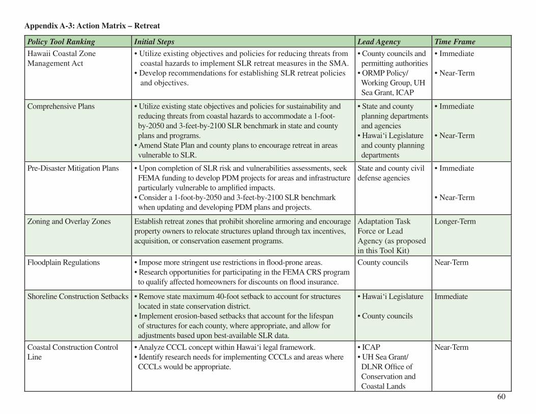
Appendix A-3: Action Matrix – Retreat
Policy Tool Ranking Initial Steps Lead Agency Time Frame
Hawaii Coastal Zone Management Act
• Utilize existing objectives and policies for reducing threats from coastal hazards to implement SLR retreat measures in the SMA.• Develop recommendations for establishing SLR retreat policies and objectives.
• County councils and permitting authorities• ORMP Policy/ Working Group, UH Sea Grant, ICAP
• Immediate
• Near-Term
Comprehensive Plans • Utilize existing state objectives and policies for sustainability and reducing threats from coastal hazards to accommodate a 1-foot- by-2050 and 3-feet-by-2100 SLR benchmark in state and county plans and programs. • Amend State Plan and county plans to encourage retreat in areas vulnerable to SLR.
• State and county planning departments and agencies• Hawai‘i Legislature and county planning departments
• Immediate
• Near-Term
Pre-Disaster Mitigation Plans • Upon completion of SLR risk and vulnerabilities assessments, seek FEMA funding to develop PDM projects for areas and infrastructure particularly vulnerable to amplified impacts.• Consider a 1-foot-by-2050 and 3-feet-by-2100 SLR benchmark when updating and developing PDM plans and projects.
State and county civil defense agencies
• Immediate
• Near-Term
Zoning and Overlay Zones Establish retreat zones that prohibit shoreline armoring and encourage property owners to relocate structures upland through tax incentives, acquisition, or conservation easement programs.
Adaptation Task Force or Lead Agency (as proposed in this Tool Kit)
Longer-Term
Floodplain Regulations • Impose more stringent use restrictions in flood-prone areas.• Research opportunities for participating in the FEMA CRS program to qualify affected homeowners for discounts on flood insurance.
County councils Near-Term
Shoreline Construction Setbacks • Remove state maximum 40-foot setback to account for structures located in state conservation district. • Implement erosion-based setbacks that account for the lifespan of structures for each county, where appropriate, and allow for adjustments based upon best-available SLR data.
• Hawai‘i Legislature
• County councils
Immediate
Coastal Construction Control Line
• Analyze CCCL concept within Hawai‘i legal framework. • Identify research needs for implementing CCCLs and areas where CCCLs would be appropriate.
• ICAP• UH Sea Grant/ DLNR Office of Conservation and Coastal Lands
Near-Term
60

Policy Tool Ranking Initial Steps Lead Agency Time Frame
Rebuilding Restrictions Strengthen rebuilding restrictions for nonconforming structures. County councils Immediate
Subdivision Approvals Utilize available data to protect public health and safety by restricting residential subdivisions in areas prone to current and future coastal hazards such as subsidence, erosion, storm surge, and SLR.
County planning and permitting authorities
Near-Term
Cluster Development Adopt cluster development ordinances that restrict development in low-lying areas or in areas containing natural flood buffers. Clustering could be mandatory or incentivized.
County councils Near-Term
Environmental Review Amend HRS ch. 343 and applicable administrative rules to explicitly incorporate review of SLR and climate change impacts of a proposed action or development project.
Hawai‘i Legislature Immediate
Rolling Easement Statutes Develop rolling easement policy to incorporate into State Plan or HCZMA that establishes SLR retreat goals.
UH Sea Grant, ICAP Near-Term
Buffer Zones Identify and map natural inundation buffers (e.g., sand dunes and wetlands) requiring protection and establish mandatory buffer distances.
DLNR Office of Conservation and Coastal Lands, UH Sea Grant, Adaptation Task Force or Lead Agency (as proposed in this Tool Kit)
Near-Term
Capital Improvement Programs Require consideration of multiple scenarios of SLR when developing and approving capital improvement programs.
Executive Order Immediate
Land Acquisitions Amend Hawai‘i Legacy Land Conservation Program to prioritize land threatened by SLR inundation, erosion, and other coastal hazards with the purpose of protecting public health and safety.
Hawai‘i Legislature Longer-Term
Conservation Easements Amend HRS ch. 198 to authorize non-profit organizations to hold conservation easements for the purpose of protecting life and property from coastal hazards and inundation due to climate change and SLR.
Hawai‘i Legislature Longer-Term
Rolling Conservation Easements Analyze rolling conservation easement concept within Hawai‘i legal framework.
ICAP Immediate
61

Policy Tool Ranking Initial Steps Lead Agency Time Frame
Mandatory Real Estate Disclosures
• Require disclosure of erosion rates for coastal properties.• Upon completion of SLR risk and vulnerability assessments, require disclosure of such information for properties located in coastal high hazard areas.
Hawai‘i Legislature • Immediate• Near-Term
Tax Incentives Develop tax incentive program for developers and property owners who relocate structures landward, site development in upland areas, conserve open space along the shoreline, and/or preserve or restore natural flood buffers.
State of Hawai‘i Department of Taxation
Longer-Term
Transfer of Development Rights Programs
Develop TDR programs that facilitate SLR retreat. County planning departments
Longer-Term
62

Appendix B-1: Federal Resources and Initiatives
APPENDIX B: SELECTED SEA-LEVEL RISE ADAPTATION RESOURCES AND INITIATIVES
Agency Action Date Website
Environmental Protection Agency (EPA) – Climate Ready Estuaries
Rolling Easements (James G. Titus)
2011 http://www.epa.gov/cre/downloads/rollingeasementsprimer.pdf
National Aeronautics and Space Administration (NASA) – Global Climate Change
Generates climate change and sea-level rise data
Ongoing http://climate.nasa.gov/
NOAA – Climate Services Produces global, national, and regional climate data and maps and educational resources
Ongoing http://www.climate.gov/#climateWatch
NOAA – Coastal Services Center (CSC)
• Coastal Climate Adaptation website• Digital Coast website• Coastal Sea-Level Change and Societal Challenge Needs Assessment Report
• Ongoing• Ongoing• September 2011
http://collaborate.csc.noaa.gov/climateadaptation/default.aspxhttp://www.csc.noaa.gov/digitalcoast/index.htmlhttp://www.floods.org/ace-files/documentlibrary/committees/Coastal/NOAA_Coastal_Sea_Level_Change_Societal_Challenge_Needs_Assessment_Report.pdf
NOAA – National Climatic Data Center (NCDC)
Produces climate publications Ongoing http://www.ncdc.noaa.gov/oa/about/about.html
NOAA – Office of Ocean and Coastal Resource Management (OCRM)
Adapting to Climate Change: A Planning Guide for State and Coastal Managers
2010 http://coastalmanagement.noaa.gov/climate/adaptation.htmlhttp://coastalmanagement.noaa.gov/climate/docs/adaptationguide.pdf
NOAA – Pacific Climate Information System (PaCIS)
Provides a programmatic framework for integrating ongoing and future climate observations, operational forecasting services and climate projections, research, assessment, data management, outreach, and education into planning efforts throughout the U.S. and affiliated Pacific islands
Ongoing http://www.noaaclimatepacis.org/old/leftmenuitem.php?content=history
NOAA – Pacific Services Center (PSC)
Provides services and information for Pacific and coastal communities
Ongoing http://www.csc.noaa.gov/psc/about.html
63
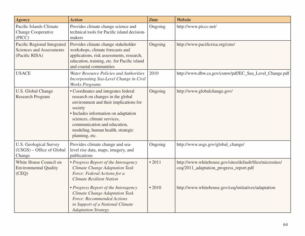
Agency Action Date Website
Pacific Islands Climate Change Cooperative (PICC)
Provides climate change science and technical tools for Pacific island decision-makers
Ongoing http://www.piccc.net/
Pacific Regional Integrated Sciences and Assessments (Pacific RISA)
Provides climate change stakeholder workshops, climate forecasts and applications, risk assessments, research, education, training, etc. for Pacific island and coastal communities
Ongoing http://www.pacificrisa.org/cms/
USACE Water Resource Policies and Authorities Incorporating Sea-Level Change in Civil Works Programs
2010 http://www.dbw.ca.gov/csmw/pdf/EC_Sea_Level_Change.pdf
U.S. Global Change Research Program
• Coordinates and integrates federal research on changes in the global environment and their implications for society• Includes information on adaptation sciences, climate services, communication and education, modeling, human health, strategic planning, etc.
Ongoing http://www.globalchange.gov/
U.S. Geological Survey (USGS) – Office of Global Change
Provides climate change and sea-level rise data, maps, imagery, and publications
Ongoing http://www.usgs.gov/global_change/
White House Council on Environmental Quality (CEQ)
• Progress Report of the Interagency Climate Change Adaptation Task Force: Federal Actions for a Climate Resilient Nation
• Progress Report of the Interagency Climate Change Adaptation Task Force: Recommended Actions in Support of a National Climate Adaptation Strategy
• 2011
• 2010
http://www.whitehouse.gov/sites/default/files/microsites/ceq/2011_adaptation_progress_report.pdf
http://www.whitehouse.gov/ceq/initiatives/adaptation
64

Agency Action Date Website
Pacific Islands Climate Change Cooperative (PICC)
Provides climate change science and technical tools for Pacific island decision-makers
Ongoing http://www.piccc.net/
Pacific Regional Integrated Sciences and Assessments (Pacific RISA)
Provides climate change stakeholder workshops, climate forecasts and applications, risk assessments, research, education, training, etc. for Pacific island and coastal communities
Ongoing http://www.pacificrisa.org/cms/
USACE Water Resource Policies and Authorities Incorporating Sea-Level Change in Civil Works Programs
2010 http://www.dbw.ca.gov/csmw/pdf/EC_Sea_Level_Change.pdf
U.S. Global Change Research Program
• Coordinates and integrates federal research on changes in the global environment and their implications for society• Includes information on adaptation sciences, climate services, communication and education, modeling, human health, strategic planning, etc.
Ongoing http://www.globalchange.gov/
U.S. Geological Survey (USGS) – Office of Global Change
Provides climate change and sea-level rise data, maps, imagery, and publications
Ongoing http://www.usgs.gov/global_change/
White House Council on Environmental Quality (CEQ)
• Progress Report of the Interagency Climate Change Adaptation Task Force: Federal Actions for a Climate Resilient Nation
• Progress Report of the Interagency Climate Change Adaptation Task Force: Recommended Actions in Support of a National Climate Adaptation Strategy
• 2011
• 2010
http://www.whitehouse.gov/sites/default/files/microsites/ceq/2011_adaptation_progress_report.pdf
http://www.whitehouse.gov/ceq/initiatives/adaptation
Appendix B-2: Hawai‘i State and Local Resources and Initiatives
Agency Action Date Website
CZM Program for Marine and Coastal Affairs
• Reviews and periodically updates the ORMP• Coordinates overall implementation of ORMP• Facilitates policy groups and working groups with members from federal, state, and county agencies and non-governmental organizations to coordinate ORMP implementation measures
Ongoing http://hawaii.gov/dbedt/czm/ormp/ormp.php
Honolulu Board of Water Supply
Watershed Management Plans for Ko‘olau Loa and Wai‘anae
2009 http://www.boardofwatersupply.com/files/KL_WMP_PreFinal_Plan_072709_rev2.pdfhttp://www.boardofwatersupply.com/files/WWMP_Final_Report_Full_Aug2009.pdf
State of Hawai‘i Department of Transportation, Harbors Division
Hawai‘i Island Commercial Harbors 2035 Master Plan
Forthcoming http://www.hawaiiharborsplan.com/master_plan_process.htm
ORMP Working Group (Established under the CZM)
A Framework for Climate Change Adaptation in Hawaii
2009 http://icap.seagrant.soest.hawaii.edu/sites/seagrant.soest.hawaii.edu/files/publications/climate_change_adaptation_framework_2009_2.pdf
UH Sea Grant and DLNR Kailua Beach and Dune Management Plan
2010 http://seagrant.soest.hawaii.edu/kailua-beach-and-dune-management-plan
65
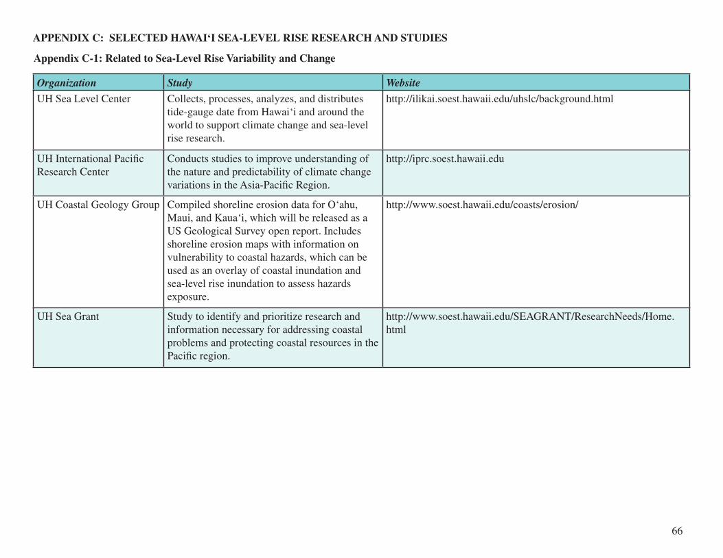
Appendix C-1: Related to Sea-Level Rise Variability and Change
APPENDIX C: SELECTED HAWAI‘I SEA-LEVEL RISE RESEARCH AND STUDIES
Organization Study Website
UH Sea Level Center Collects, processes, analyzes, and distributes tide-gauge date from Hawai‘i and around the world to support climate change and sea-level rise research.
http://ilikai.soest.hawaii.edu/uhslc/background.html
UH International Pacific Research Center
Conducts studies to improve understanding of the nature and predictability of climate change variations in the Asia-Pacific Region.
http://iprc.soest.hawaii.edu
UH Coastal Geology Group Compiled shoreline erosion data for O‘ahu, Maui, and Kaua‘i, which will be released as a US Geological Survey open report. Includes shoreline erosion maps with information on vulnerability to coastal hazards, which can be used as an overlay of coastal inundation and sea-level rise inundation to assess hazards exposure.
http://www.soest.hawaii.edu/coasts/erosion/
UH Sea Grant Study to identify and prioritize research and information necessary for addressing coastal problems and protecting coastal resources in the Pacific region.
http://www.soest.hawaii.edu/SEAGRANT/ResearchNeeds/Home.html
66

Appendix C-2: Related to Sea-Level Rise Impacts, Risks, and Vulnerabilities
Organization Study
O‘ahu Metropolitan Planning Organization (forthcoming)
• Study to validate conceptual model for determining the effects of climate change on transportation infrastructure. See http://www.oahumpo.org/reports/transportation_vulnerability_due_to_climate_change.html
UH Coastal Geology Group (forthcoming)
• Hourly exceedance study estimating the number of hours per year that critical areas would become inundated under three sea-level rise scenarios. • Produce risk and vulnerability maps depicting impacts.
UH Pacific Islands Climate Science Center (forthcoming)
• Will provide land managers in federal, state, and local agencies access to best-available science regarding the impacts of climate change and other landscape-scale stressors. Will expand climate science capabilities without building new facilities or duplicating existing capabilities and collaborate with a consortium of partners across the entire science community. See http://www.doi.gov/news/pressreleases/Secretary-Salazar-Names-University- of-Massachusetts-Amherst-to-Host-Northeast-Climate-Science-Center.cfm
UH Sea Grant, funded by the NOAA Coastal Storms Program (CSP) (forthcoming)
• Risk and vulnerability assessment of sea-level rise in Hawai‘i, beginning with the low-lying, urban corridor between Diamond Head and Pearl Harbor in Honolulu.• Identify infrastructure, map potential flooding and coastal inundation at the confluence of high tides and rainfall.• Model storm surge inundation under 1-foot, 2-foot, and 3-foot sea-level rise scenarios. • Communicate study results to local emergency and resource managers, decision-makers, and affected communities to provide guidance for land use and emergency management planning.
67

68
Endnotes1 Contribution of Working Grp. I to the Fourth Assessment Report of the IPCC, Global Climate Projections 7 (S. Solomon et al. eds., 2009) [hereinafter IPCC Working Grp. I].
2 U.S. Global Change Research Program, Global Climate Change Impacts in the United States 28 (Thomas R. Karl et al. eds., 2009) [hereinafter U.S. Global Change].3 Id. at 32.4 Id. at 34. 5 Id. at 36.6 Id. at 12.7 Working Groups I, II and III to the IPCC Fourth Assessment Report, Climate Change 2007: Synthesis Report 39 (Abdelkader Allali et al. eds., 2008) [hereinafter IPCC Synthesis Report].8 Dr. Chip Fletcher, ICAP, Hawai‘i’s Changing Climate: Briefing Sheet 1-6 (2010), available at http://icap.seagrant.soest.hawaii.edu/ sites/seagrant.soest.hawaii.edu/files/publications/ClimateBriefing__web.pdf [hereinafter Fletcher, ICAP Briefing Sheet].9 U.S. Global Change, supra note 2, at 18.10 Charles H. Fletcher, Sea level by the end of the 21st century: A review, Shore & Beach, Fall 2009, at 4, available at http://www. soest.hawaii.edu/coasts/publications/fletcher2009_sealevelreview.pdf [hereinafter Fletcher, Sea level].11 E. Rignot et al., Acceleration of the contribution of the Greenland and Antarctic ice sheets to sea level rise, Geophys. Res. Lett., vol. 38, L05503, doi:10.1029/2011GL046583 (2011).12 Martin Vermeer & Stefan Rahmstorf, Proceedings of the National Academy of Sciences, Global sea level linked to global temperature (2009), available at http://www.pnas.org/cgi/doi/10.1073/pnas.0907765106 .13 S. Jevrejeva et al., Sea-level rise projections to AD2500 with a new generation of climate change scenarios, Global and Planetary Change, doi:10.1016/j.glopacha.2001.09.006 (2011).14 Fletcher, ICAP Briefing Sheet, supra note 8, at 3.15 IPCC Working Grp. I, supra note 1, at 812. 16 Pfeffer et al., Kinematic Constraints on Glacier Contributions to 21st-Century Sea-Level Rise, Science Magazine, Sept. 5, 2008.17 E-mail from Dr. Charles H. Fletcher, Professor, Dep’t of Geology and Geophysics, SOEST (Sept. 17, 2011); See also Fletcher, Sea level, supra note 10, at 4.18 IPCC Fifth Assessment Report, IPCC, http://www.ipcc.ch/index.htm (last visited Sept. 27, 2011).19 Dennis Hwang & Maxine Burkett, ICAP, UH Sea Grant, Shoreline Impacts, Setback Policy, and Sea Level Rise 2 (2009), available at http://seagrant.soest.hawaii.edu/sites/seagrant.soest.hawaii.edu/files/publications/ICAPwhitepaperGG-10-01.pdf .20 U.S. Global Change, supra note 2, at 146.21 Fletcher, ICAP Briefing Sheet, supra note 8, at 3.22 Interview with Dr. Charles H. Fletcher, Professor, Dep’t of Geology and Geophysics, SOEST, in Honolulu, Haw. (May 10, 2011).23 Fletcher, ICAP Briefing Sheet, supra note 8, at 4.24 U.S. Global Change, supra note 2, at 146.25 Fletcher, ICAP Briefing Sheet, supra note 8, at 4.26 U.S. Global Change, supra note 2, at 147.27 Mapping cumulative human impacts, Hawai‘i Institute of Marine Biology, http://www.hawaii.edu/himb/nwhi/?page_id-290 (last visited Sept. 12, 2011). 28 Y. Firing & M.A. Merrifield, Extreme sea level events at Hawaii: influence of mesoscale eddies, Geophys. Res. Lett., vol. 31, L24306, doi:10.1029/2004GL021539 (2004).29 Fletcher, ICAP Briefing Sheet, supra note 8, at 4.30 Michael W. Guidry & Fred T. Mackenzie, Dep’t of Oceanography, SOEST, Climate Change, Water Resources, and Sustainability in the Pacific Basin: Emphasis on O‘ahu, Hawai‘i and Majuro Atoll Republic of the Marshall Islands 78 (2006), available at http://seagrant.soest.hawaii.edu/sites/seagrant.soest.hawaii.edu/files/publications/Climate_Case_Study_Final.pdf .31 Sustainability Task Force, State of Haw., Hawai‘i 2050 Sustainability Plan 36 (2008), available at http://www.hawaii2050.org/ images/uploads/Hawaii2050_Plan_FINAL.pdf .32 2007 Haw. Sess. Laws, Act 234 § 1(a) (Haw. 2007).33 Id. See also Douglas A. Codiga, Act 234: Hawaii’s Climate Change Law, 12 Haw. B.J. 6 (2008).34 Mathias Ruth et al., Ctr. for Integrative Envtl. Research at the Univ. of Md., The US Economic Impacts of Climate Change and the Costs of Inaction 38 (2007), available at http://www.cier.umd.edu/documents/US Economic Impacts of Climate Change and the Costs of Inaction.pdf .35 U.S. Global Change, supra note 2, at 13.36 Fed. Ins. Admin., FEMA, Projected Impact of Relative Sea Level Rise on the National Flood Insurance Program 56 (1991), available at http://epa.gov/climatechange/effects/downloads/flood_insurance.pdf .37 Evan Lehmann, Flood-Prone Land Likely to Increase by 45%, N.Y. Times, Jul. 22, 2011, http://www.nytimes.com/ cwire/2011/07/22/22climatewire-flood-prone-land-likely-to-increase-by-45-a-19117.html?pagewanted=all .38 See C.H. Fletcher, R. Boyd, W.J. Neal & V. Tice, Living on the Shores of Hawai‘i: Natural Hazards, the Environment, and Our Communities 371 (2010), information available at http://www.uhpress.hawaii.edu/p-6497-978082483433.aspx .39 Guidry & Mackenzie, supra note 30.

69
40 Ruth et al., supra note 34, at 39.41 Lucy Jokiel, Big Wave, Big Picture – Beneath the surface of tsunamis’ past, present and future, Honolulu Weekly, June 1, 2011, http://honoluluweekly.com/cover/2011/05/big-wave-big-picture/ . 42 Guidry & Mackenzie, supra note 30.43 U.S. Global Change, supra note 2, at 148.44 Guidry & Mackenzie, supra note 30.45 Waikiki Improvement Association, Economic Impact Analysis of the Potential Erosion of Waikiki Beach, Final Report 12 (2008). 46 Id. at 15. 47 U.S. Global Change, supra note 2, at 148.48 Guidry & Mackenzie, supra note 30, at 73-74.49 Pew Ctr., Climate Change 101: Adaptation 40 (2011).50 2007 Haw. Sess. Laws, Act 234 § 2 (codified at Haw. Rev. Stat. § 342B-71).51 IPCC Working Grp. I, supra note 1, at 827.52 NOAA, Adapting to Climate Change: A Planning Guide for State Coastal Managers 1 (2010), available at http:// coastalmanagement.noaa.gov/climate/docs/adaptationguide.pdf [hereinafter NOAA, Planning Guide].53 Edna Sussman et al., Climate Change Adaptation: Fostering Progress Through Law and Regulation, 18 N.Y.U. Envtl. L.J. 55, 56 (2010).54 Contribution of Working Grp. II to the IPCC Fourth Assessment Report, Impacts, Adaptation, and Vulnerability 20 (M.L. Parry et al. eds., 2007) [hereinafter IPCC Working Grp. II].55 Pew Ctr., supra note 49, at 5.56 IPCC Working Grp. II, supra note 54, at 19.57 Scott Glenn, ICAP, Summary of Hawai‘i State Agency Perspectives on Sea-Level Rise 2 (2011).58 Id. at 1-3.59 San Francisco Bay Conservation and Development Commission, Resolution No. 11-08, New Climate Change Findings and Policies to the Bay Plan; And Revising the Bay Plan Tidal Marsh and Tidal Flats; Safety of Fills; Protection of the Shoreline; and Public Access Findings and Policies 12 (adopted Oct. 6, 2011), available at http://www.bcdc.ca.gov/proposed_bay_plan/10-01Resolution. pdf [hereinafter San Francisco Bay Plan].60 Glenn, supra note 57, at 3-4.61 Douglas Codiga, Dennis Hwang & Chris Delaunay, ICAP, UH Sea Grant, Climate Change and Regulatory Takings in Coastal Communities (2011), available at http://seagrant.soest.hawaii.edu/sites/seagrant.soest.hawaii.edu/files/publications/web_ climatechangeregulatorytakingshi.pdf .62 Ctr. for Sci. in the Earth Sys. (Climate Impacts Grp.), Joint Inst. for the Study of the Atmosphere and Ocean, Univ. of Wash. & King Cnty. Wash., Preparing for Climate Change: A Guidebook for Local, Regional, and State Governments 27 (2007), available at http://cses.washington.edu/db/pdf/snoveretalgb574.pdf [hereinafter King Cnty., Guidebook].63 Id. at 27-28.64 Joseph A. Siegel, Collaborative Decision Making on Climate Change in the Federal Government, 27 Pace Envtl. L. Rev. 257, 266 (2009/2010).65 Id. at 267; NOAA, Planning Guide, supra note 52, at 17.66 Siegel, supra note 64, at 267.67 NOAA, Planning Guide, supra note 52, at 2.68 Siegel, supra note 64, at 267.69 San Francisco Bay Plan, supra note 59, at 12. 70 U.S. Comm’n on Ocean Policy, An Ocean Blueprint for the 21st Century, Final Report 152 (2004).71 Pew Ctr., supra note 49, at 6.72 King Cnty., Guidebook, supra note 62.73 State Adaptation Plans, Pew Ctr., http://www.pewclimate.org/what_s_being_done/in_the_states/adaptation_map.cfm (last visited Aug. 5, 2011).74 Brett Roeth, Proposed California Law Would Require Sea-Level Rise Plans, Energy & Climate Partnership Americas Urb. Plan. Initiative, June 16, 2011, http://ecpaplanning.org/2011/06/proposed-california-law-would-require-sea-level-rise-plans/ .75 Fletcher, Sea level, supra note 10.76 Glenn, supra note 57, at 8. 77 Id. at 2.78 See id., at 4-5.79 NOAA, Planning Guide, supra note 52, at 18.80 See Cal. Exec. Order No. S-13-08 (2008), available at http://gov.ca.gov/news.php?id=11036 . 81 See id.82 See USACE, Water Resource Policies and Authorities Incorporating Sea-Level Change in Civil Works Programs 1-3 (Jul. 1, 2009), available at http://www.dbw.ca.gov/csmw/pdf/EC_Sea_Level_Change.pdf [hereinafter USACE, Civil Works]. 83 Cal. Exec. Order No. S-13-08, at art. 5.

70
84 California Climate Center, The Impacts of Sea-Level Rise on the California Coast (2009), available at http://www.pacinst.org/ reports/sea_level_rise/index.htm .85 Cal. Exec. Order No. S-13-08, at art. 3.86 Jessica Grannis, Georgetown Climate Center, Adaptation Tool Kit: Sea-Level Rise & Coastal Land Use – How Governments Can Use Land Use Practices to Adapt to Sea-Level Rise 20 (forthcoming 2011), available at http://www.georgetownclimate.org/sites/ default/files/Adaptation_Tool_Kit_SLR.pdf .87 The NOAA Coastal Services Center, has identified five general categories of information necessary for coastal decision-makers to address the impacts of sea-level change: (1) Improved ability to predict sea-level change; (2) assessment and predictions of sea- level change impacts to coastal communities (trade, tourism, infrastructure, etc.); (3) Science-based assessment and predictions of sea-level change impacts to coastal ecosystems; (4) Adaptation and mitigation strategies for coastal decision-makers; (5) Engagement, education, and outreach to stakeholders on sea-level change science and adaptation strategies. NOAA Coastal Services Center, Coastal Sea-Level Change Societal Challenge Needs Assessment Report (2011), available at http://www.floods.org/ace-files/ documentlibrary/committees/Coastal/NOAA_Coastal_Sea_Level_Change_Societal_Challenge_Needs_Assessment_Report.pdf .88 State of Hawai‘i Multi-Hazard Mitigation Plan 2010 Update, ch. 5.6.2 (2010), available at http://www.scd.hawaii.gov/2010_hmp. html [hereinafter State Multi-Hazard].89 See NOAA, Planning Guide, supra note 52, at 20.90 See Sandra S. Nichols & Carl Bruch, New Frameworks for Managing Dynamic Coasts: Legal and Policy Tools for Adapting U.S. Coastal Zone Management to Climate Change, 1 Sea Grant L. & Pol’y J. 19, 28 (2008).91 See NOAA, Planning Guide, supra note 52, at 20.92 See Mindy Pennybacker, Get Ready, Here it Comes! Tsunami Trash, Plastic Soup, Rising Seas, Honolulu Weekly, May 18, 2011, http://honoluluweekly.com/cover/2011/05/get-ready-here-it-comes-tsunami-trash-plastic-soup-rising-seas/ .93 See Terri L. Cruce, Adaptation Planning – What U.S. States and Localities are Doing (Pew Ctr., Working Paper, 2009), available at http://www.pewclimate.org/publications/workingpaper/adaptation-planning-what-us-states-and-localities-are-doing.94 Authorizing Legislation – Sea Level Rise Task Force, N.Y. Dep’t of Envtl. Conservation, http://www.dec.ny.gov/energy/45895.html (last visited Aug. 17, 2011). 95 My State – Hawaii, OCRM, http://coastalmanagement.noaa.gov/mystate/hw.html (last visited Sept. 20, 2011).96 Haw. Rev. Stat. § 205A-5.97 Id. § 205A-2.98 Id. § 205A-26.99 Id. ch. 205A.100 Id. § 205-2(b)(6)(A).101 Id. § 205A-2(c)(6).102 Fletcher, ICAP Briefing Sheet, supra note 8, at 3.103 S.C. Code Ann. Regs. 30-1(c).104 Id. at 30-1(c)(4).105 Id. at 30-1(c)(6).106 R.I. Gen. Laws § 46-23-1(f)(2). 107 The State of R.I., Coastal Resources Management Program, As Amended, Sec. 145 (2008).108 Id. at Sec. 145(c). 109 Me. Rev. Stat. tit. 38 § 1801(4). 110 06-096-355 Me. Code R. § 5(C).111 Duck, N.C., CAMA Core Land Use Plan (2005), available at http://www.townofduck.com/pzi.landuseplan.pdf .112 Duck, N.C., Code of Ordinances tit. XV, ch. 152.113 Haw. Rev. Stat. § 205A-4(a).114 My State – South Carolina, OCRM, http://coastalmanagement.noaa.gov/mystate/sc.html (last visited Sept. 20, 2011); My State – Rhode Island, OCRM, http://coastalmanagement.noaa.gov/mystate/ri.html (last visited Sept. 20, 2011).115 David L. Callies, Regulating Paradise, Land Use Controls in Hawai‘i 33 (2nd ed. 2010).116 Haw. Rev. Stat. § 226-1.117 See id. § 226-52(a).118 Id. § 226-52(b)(2)(A-E).119 See Development/Sustainable Communities Plans, City and Cnty. of Honolulu Dep’t of Planning and Permitting, http://www. honoluludpp.org/planning/DevSustCommPlans.asp (last visited Aug. 5, 2011); Kaua‘i Cnty., Haw., Gen. Plan Ordinance, available at http://www.kauai.gov/Government/Departments/PlanningDepartment/TheKauai’iGeneralPlan/GeneralPlanOrdinance/tabid/131/ Default.aspx#12target . 120 See Development/Sustainable Communities Plans, supra note 119.121 See Community Plans, Cnty. of Maui, Haw., http://www.co.maui.hi.us/index.aspx?NID=423 (last visited Aug. 5, 2011).122 See Hawai‘i County Community Development Plans, Hawai‘i Cnty. Dep’t of Planning, http://www.hawaiicountycdp.info/ (last visited Aug. 5, 2011).123 See Callies, supra note 115, at 39.124 S.B. 283 S.D. 1 H.D. 1 C.D. 1 Gov. Msg. No. 1285 (Haw. 2011).

71
125 Id.126 Haw. Rev. Stat. § 226-102.127 Id. § 226-2.128 Id. § 226-52(a)(5).129 Id. § 226-52(a)(4).130 Id. § 226-52(a)(3)131 Id. § 226-13(b)(5). 132 Fletcher, ICAP Briefing Sheet, supra note 8, at 3.133 S.B. 283 S.D. 1 H.D. 1 C.D. 1 Gov. Msg. No. 1285 (Haw. 2011).134 Haw. Rev. Stat. § 226-104(b)(9).135 See id. ch. 206E; see also Callies, supra note 115, at 169-208.136 Cnty. of Maui, State of Haw., County of Maui 2030 General Plan, Countywide Policy Plan 14, 74 (2010), available at http://www. co.maui.hi.us/DocumentView.aspx?DID=11132 [hereinafter Maui 2030 General Plan].137 San Francisco Bay Plan, supra note 59, at 16-19. 138 Maui 2030 General Plan, supra note 136, at 14.139 Id. at 74.140 Maui Cnty., Haw., Code § 2.80B.030.141 Long Range Div., Cnty. of Maui Planning Div., Maui Island Plan, General Plan 2030 DRAFT §§ 3-8 – 3-9 (2009) available at http://www.co.maui.hi.us/Documentview.aspx?DID=10683 [hereinafter Maui Island Plan]. 142 Draft Maui Island Plan, Cnty. of Maui, Haw., http://www.co.maui.hi.us/index.aspx?NID=1120 (last visited Aug. 16, 2011).143 Maui Cnty., Haw., Code § 2.80B.030(B).144 Callies, supra note 115, at 35.145 Haw. Rev. Stat. § 226-2.146 Id. § 226-8(b)(1).147 Id. § 226-2.148 Id. 149 Pre-Disaster Mitigation Grant Program, FEMA, http://www.fema.gov/government/grant/pdm/index.shtm (last visited Sept. 20, 2011). 150 Grannis, Georgetown Tool Kit, supra note 86, at 19.151 Pre-Disaster Mitigation Grant Program, supra note 149. 152 See State Multi-Hazard, supra note 88, at ch. 6.16.153 Id.154 Civil Def. Agency, Cnty. of Maui, Multi-Hazard Mitigation Plan 2010, Version for FEMA Review, ch. 13-1 (2010), available at http://co.maui.hi.us/DocumentView.asp?DID=2407 [hereinafter Maui Multi-Hazard]. The New York City Comprehensive Waterfront Plan includes strategies for working with city, state, and federal agencies and stakeholders to incorporate the potential effects of climate change into the city’s Natural Hazard Mitigation Plan and analyzing future flood and storm surge risks for the city’s Coastal Storm Plan. New York City Comprehensive Waterfront Plan Vision 2020 113 (Mar. 2011) [hereinafter NYC Plan]. 155 Maui Multi-Hazard, supra note 154, at ch. 13.6.2. 156 Id. at ch. 1-7.157 Maui Island Plan, supra note 141, § 3-4.158 Id.159 Haw. Rev. Stat. § 46-4(a).160 Callies, supra note 115, at 51-55.161 Lum Yip Kee, Ltd. v. City and Cnty. of Honolulu, 767 P.2d 815 (Haw. 1989). 162 Id.163 See Callies, supra note 115, at 58-59. 164 See id. at 55-76.165 Grannis, Georgetown Tool Kit, supra note 86, at 20.166 Or. Admin. R. 660-015-0010(3).167 Tillamook Cnty., Or., Land Use Ordinance art. 3 § 3.085, available at http://www.co.tillamook.or.us/gov/ComDev/documents/ luo/3.085.pdf . 168 East Hampton, N.Y., Code § 255-3-81.169 Id. § 255-3-81A.170 Id. §§ 255-3-82D, 255-3-85B.171 See id. § 255-4-29. 172 Fed. Ins. Admin., FEMA, NFIP, Program Description 12-13 (2002) [hereinafter NFIP Program Description].173 Id. at 3.174 Id. at 6-7.

72
175 See City and Cnty. of Honolulu, Haw., Rev. Ordinances § 21-9.10, available at http://www1.honolulu.gov/council/ocs/ roh/21990.pdf ; Maui Cnty., Haw., Code § 19.62; Hawai‘i Cnty., Haw., Code ch. 27, available at http://www.co.hawaii. hi.us/countycode.html#countycode ; Kaua‘i Cnty., Haw., Code § 8-12, available at http://www.kauaiboard.com/xSites/Agents/ KauaiBoardofREALTORS/Content/UploadedFiles/CZO (PDF).pdf . 176 NFIP Program Description, supra note 172, at 31. 177 FEMA, Post-Preliminary Processing – Digital Flood Map, Hawai‘i County, HI, Project Status Fact Sheet (Jul. 21, 2011). 178 Jason Armstrong, Thousands more may need flood insurance, Hawaii Tribune Herald, Aug. 3, 2011, http://www.hawaiitribune- herald.com/sections/news/local-news/thousands-more-may-need-flood-insurance.html .179 Sherry Bracken, Hawaii County Gets Flood Insurance Rate Reduction, Big Island News Center, Aug. 11, 2011, http://www. bigislandnewscenter.com/hawaii-county-gets-flood-insurance-rate-reduction/ .180 Grannis, Georgetown Tool Kit, supra note 86, at 26 (citing U.S. Climate Change Sci. Program, Coastal Sensitivity to Sea-Level Rise: A Focus on the Mid-Atlantic Region – Synthesis and Assessment Product 4.1 at 18 (2009)). 181 Fletcher, ICAP Briefing Sheet, supra note 8, at 3-4.182 See NFIP Program Description, supra note 172, at 2 (stating that the primary purposes of the NFIP are to “[b]etter indemnify individuals for flood losses through insurance; Reduce future flood damages through State and community floodplain management programs; and Reduce Federal expenditures for disaster assistance and flood control”). 183 Grannis, Georgetown Tool Kit, supra note 86, at 27-28.184 City and Cnty. of Honolulu, Haw., Rev. Ordinances § 21-9.10.185 Kaua‘i Cnty., Haw., Code § 8-16. 186 Grannis, Georgetown Tool Kit, supra note 86, at 28.187 See City and Cnty. of Honolulu, Haw., Rev. Ordinances § 21-9.10; Maui Cnty., Haw., Code § 19.62; Hawai‘i Cnty., Haw., Code ch. 27.188 Grannis, Georgetown Tool Kit, supra note 86, at 28.189 Chatham, Mass., Protective Bylaw § IVA.190 Wes Shaw, Mass. Office of Coastal Zone Mgmt., Case Study – A Cape Cod Community Prevents New Residence in Floodplains (Ann Donovan ed. 2008), available at http://www.mass.gov/czm/stormsmart/resources/stormsmart_chatham.pdf (citing Gove v. Zoning Bd. of Appeals of Chatham, 831 N.E.2d 865 (Mass. 2005)).191 Falmouth, Mass., Wetland Regs. 10.00. 192 Kem Lowry, 11th International Congress, Asian Planning Schools Association (“APSA”), Sustaining Hawaii’s Beaches, Climate Change and Land Use 7 (2011).193 Nichols & Bruch, supra note 90, at 32. To implement climate change adaptation strategies included in the New York City Comprehensive Waterfront Plan, the city will work with FEMA and the insurance industry to encourage consideration of more accurate data on current and future flood and storm risks and partner with FEMA to update FIRM maps. NYC Plan, supra note 154, at 113. 194 Haw. Rev. Stat. § 205A-1.195 Id. § 205A-43(a).196 See id. § 205A-45(a).197 Hwang & Burkett, supra note 19, at 6 (citing C.M. Anderson, Fed. Ins. Admin. Dep’t of Hous. and Urban Dev., Final Report – Coastal Residential Structures Life Time Determination 87 (1978)). 198 Codiga, Hwang & Delaunay, supra note 61, at 11.199 Hwang & Burkett, supra note 19, at iii.200 Maui Cnty., Haw., Shoreline R. Planning Comm’n § 12-203-6.201 City and Cnty. of Honolulu, Haw., Rev. Ordinances § 22-1.4, available at http://www1.honolulu.gov/council/ocs/roh/22.pdf.202 Id. § 23-1.6.203 Haw. Cnty., Haw., Planning Dep’t R. 11-5.204 Hwang & Burkett, supra note 19, at 13.205 06-096 Me. Code R. ch. 355 § 5. 206 California Natural Resources Agency, 2009 California Climate Adaptation Strategy: A Report to the Governor of the State of California in Response to Executive Order S-13-2008 (2009), available at http://www.climatechange.ca.gov/adaptation/count/click. php [hereinafter 2009 California Adaptation]. 207 Codiga, Hwang & Delaunay, supra note 61, at 10-11.208 DLNR & UH Sea Grant, Kailua Beach and Dune Management Plan, Final Report 30-33 (2010), available at http://seagrant.soest. hawaii.edu/sites/seagrant.soest.hawaii.edu/files/publications/kailua_beach_mgmt_plan.pdf [hereinafter Kailua Plan].209 Id. at 33.210 Fla. Stat. § 161.053.211 Id.; see also Fla. Admin. Code Ann. § 62B-33. 212 Fla. Stat. § 161.053.213 Haw. Rev. Stat. § 205A-44.214 See Codiga, Hwang & Delaunay, supra note 61, at 13; City and Cnty. of Honolulu, Haw. Rev. Ordinance § 23-1, available at http://www1.honolulu.gov/council/ocs/roh/23.pdf ; Kaua‘i Cnty., Haw., Code § 8-27.

73
215 Haw. Rev. Stat. § 205A-46.216 Codiga, Hwang & Delaunay, supra note 61, at 13.217 City and Cnty. of Honolulu, Haw., Rev. Ordinances §§ 23-1.1, 1.8. 218 San Francisco Bay Plan, supra note 59, at 21. 219 Haw. Rev. Stat. § 205A-46.220 Id.221 San Francisco Bay Plan, supra note 59, at 22-23. 222 The State of R.I., Coastal Resources Management Program, Sec. 300.7(B) (2000).223 S.C. Code Ann. Regs. 30-1.224 Id. at 30-21.225 City of Malibu Local Coastal Program, Local Implementation Plan, § 4.43 (2002), available at http://www.coastal.ca.gov/ventura/ malibu-lip-final.pdf .226 Megan Higgins, Legal and Policy Impacts of Sea Level Rise to Beaches and Coastal Property, 1 Sea Grant L. & Pol’y J. 43, 53 (2008).227 City and Cnty. of Honolulu, Haw., Rev. Ordinances § 21-4.110; Maui Cnty., Haw., Code §19.500.110(b); Hawai‘i Cnty., Haw., Code § 25-4-63.228 City and Cnty. of Honolulu, Haw., Rev. Ordinances § 21-9.10; Hawai‘i Cnty., Haw., Code ch. 27-13.229 06-096-355 Me. Code R. § 6.230 S.C. Code Ann. §§ 48-39-270, 48-39-280, 48-39-290.231 Grannis, Georgetown Tool Kit, supra note 86, at 40.232 Building Code Council, State of Haw. Dep’t of Accounting & Gen. Services, http://hawaii.gov/dags/bcc (last visited Aug. 5, 2011).233 Haw. Rev. Stat. § 107-24.234 Id. § 107-25.235 Id. § 107-28.236 Haw. Admin. R. § 3-180. 237 See City and Cnty. of Honolulu, Haw., Rev. Ordinances § 21-9.10; Maui Cnty, Haw., Code § 19.62; Hawai‘i Cnty., Haw., Code ch. 27; Kaua‘i Cnty., Haw., Code § 8-12.238 NFIP Program Description, supra note 172, at 13-14.239 NOAA, Planning Guide, supra note 52, at 75.240 See City and Cnty. of Honolulu, Haw., Rev. Ordinances § 21-9.10; Maui Cnty., Haw., Code § 19.62; Hawai‘i Cnty., Haw., Code ch. 27.241 Grannis, Georgetown Tool Kit, supra note 86, at 28.242 NOAA, Planning Guide, supra note 52, at 75.243 R.I. Gen. Laws § 23-27.3-100.1.5.5. 244 NOAA, Planning Guide, supra note 52, at 73.245 Nichols & Bruch, supra note 90, at 30.246 Grannis, Georgetown Tool Kit, supra note 86, at 47 (citing FEMA, Coastal Construction Manual (FEMA 55): Principles and Practices of Planning, Siting, Designing, Constructing, and Maintaining Residential Buildings in Coastal Areas (3rd ed. 2000), available at http://www.fema.gov/rebuild/mat/fema55.shtm ).247 City and Cnty. of Honolulu, Haw., Rev. Ordinances § 22-3.4; Hawai‘i Cnty., Haw., Code § 23-23; Maui Cnty., Haw., Code § 18.04.109.248 Dennis J. Hwang, CZM, Hawaii Coastal Hazard Mitigation Guidebook 109 (2005) [hereinafter Hwang, Hazard Mitigation].249 Hwang & Burkett, supra note 19, at 6-7.250 Hawai‘i Cnty., Haw., Code § 23-37.251 Malibu, Cal., Local Coastal Program Ordinances ch. 10.4(A).252 Id. at ch. 10.4(Q).253 See Dennis J. Hwang, Hawaii Cnty. Planning Dep’t, Coastal Subsidence in Kapoho, Puna, Island and State of Hawaii (2007), available at http://hawaii.gov/dlnr/occl/manuals-reports/Coastal%20Subsidence%20Final.pdf .254 Grannis, Georgetown Tool Kit, supra note 86, at 41.255 City and Cnty. of Honolulu, Haw., Rev. Ordinances § 21-3.50-2.256 Id. § 21-3.60-1.257 Id. § 21-8.50-1.258 Maui Cnty., Haw., Code § 19.83.010.259 Hawai‘i Cnty., Haw., Code § 25-6-20.260 Grannis, Georgetown Tool Kit, supra note 86, at 42.261 Id. at 42-43.262 2009 California Adaptation, supra note 206, at 73.263 Grannis, Georgetown Tool Kit, supra note 86, at 44.264 Callies, supra note 115, at 90.265 Haw. Rev. Stat. § 205A-26.

74
266 Id. § 46-6.267 Id. § 46-6.5.268 Id. § 46-142.269 Grannis, Georgetown Tool Kit, supra note 86, at 36.270 Hwang, Hazard Mitigation, supra note 248, at 117 (2005).271 Meg Caldwell & Craig Holt Segall, No Day at the Beach: Sea Level Rise, Ecosystem Loss, and Public Beach Access Along the California Coast, 34 Ecology L.Q. 533, 563-565 (2007).272 Callies, supra note 115, at 93.273 See Haw. Rev. Stat. § 343-1.274 See generally id. ch. 343.275 Id. § 343-5.276 Id. § 343-2.277 Id. § 343-5.278 See Karl Kim et al., UH, Final Report on Hawaii’s Environmental Review System, Appendix 7-15 (2010).279 H.B. 2103, 2008 Leg., 24th Sess. (Haw. 2008).280 Id. at para. 1. 281 Id. at para. 2.282 Id.283 Mass. Gen. Laws ch. 30, § 61.284 Cal. Pub. Res. Code § 21083(b); Polly Towill & Olivier Theard, The Global Warming Solutions Act (AB 32): Raising the Temperature of California Business, Cal. Envtl. Insider, Nov. 15, 2007, at 5.285 Steven Jones, King County (WA) First in the Nation To Require Climate Change Impacts To Be Considered During Environmental Review of New Projects, Marten L. Group Envtl. News, Aug. 1, 2007, http://www.martenlaw.com/news/?20070801-climate-sepa- review .286 Massachusetts v. EPA, 549 U.S. 497 (2007). 287 Linda Larson, Local Governments Use Both Carrots and Sticks to Encourage Green Buildings, Marten L. Group Envtl. News, Dec. 5, 2007, http://www.martenlaw.com/news/?20071205-green-bldgs-encouraged.288 Grannis, Georgetown Tool Kit, supra note 86, at 55-56.289 James G. Titus, Climate Ready Estuaries, Environmental Protection Agency, Rolling Easements 5 (2011), available at http://www. epa.gov/cre/downloads/rollingeasementsprimer.pdf .290 Id. at 6-7.291 See id. (describing numerous approaches for implementing such transfers, including affirmative easements, conservation easements, restrictive covenants, future interests, migrating property lines, legislative or judicial revisions, or transferable development rights).292 Id. at 4. 293 Grannis, Georgetown Tool Kit, supra note 86, at 56-57.294 See Titus, supra note 289, at 14.295 Tex. Nat. Res. Code Ann. § 61.011.296 Id. § 61.012.297 Titus, supra note 289, at 46. 298 Tex. Nat. Res. Code Ann. § 61.013.299 Id. § 61.017.330 Id. § 61.0183.301 Id. § 61.0185.302 Id. § 61.025.303 Titus, supra note 289, at 45.304 Codiga, Hwang & Delaunay, supra note 61, at 15.305 Grannis, supra note 86, at 51; see also Nichols & Bruch, supra note 90, at 33.306 See Beach Nourishment Projects, State of Haw., DLNR, http://hawaii.gov/dlnr/occl/projects/beach-nourishment (last visited Aug. 5, 2011) (listing state-funded beach nourishment projects in Hawai‘i).307 See generally Waihe‘e Refuge, Maui Coastal Land Trust, http://www.mauicoastallandtrust.org/waihee.php (last visited Aug. 22, 2011).308 Kailua Plan, supra note 208, at 40-41.309 Fla. Stat. § 161.101.310 Malibu, Cal., Local Coastal Program Ordinances ch. 10.4.311 Md. Code Ann., Envir. § 16-201.312 Nichols & Bruch, supra note 90, at 33.313 Grannis, Georgetown Tool Kit, supra note 86, at 52.314 Haw. Admin. R. § 11-23-10(a)(1).315 Id. § 13-277-4.

75
316 Grannis, Georgetown Tool Kit, supra note 86, at 32.317 See Nichols & Bruch, supra note 90, at 33-34 (explaining that wetlands reduce tidal amplitude, dissipate wave energy, and store excess water and that dunes provide a natural buffer against erosion, shelter beachfront development, and reduce threat from high water events).318 Shoreline Change Advisory Comm., S.C. Dep’t of Health and Envtl. Control, Adapting to Shoreline Change – A Foundation for Improved Management and Planning in South Carolina, Final Report 122 (2010), available at http://scdhec.gov/administration/ library/CR-009823.pdf .319 Barnstable, Mass., Gen. Ordinances § 704.320 The State of R.I., Coastal Resources Management Program, As Amended, Sec. 150 (2003).321 9 Va. Admin. Code § 10-20-80(B).322 Grannis, Georgetown Tool Kit, supra note 86, at 34.323 See Haw. Rev. Stat. § 226-14(b)(1) (stating that one of the objectives of the Hawaii State Planning Act is to “[a]ccommodate the needs of Hawaii’s people through coordination of facility systems and capital improvement priorities in consonance with state and county plans”).324 Grannis, Georgetown Tool Kit, supra note 86, at 60 (citing David J. Brower et al., Reducing Hurricane and Coastal Storm Hazards Through Growth Management: A Guidebook for North Carolina Coastal Localities 144-48 (1987), available at http://www.csc. noaa.gov/hes/docs/general_info/Location Specific/REDUCING HURRICANE AND COASTAL STORM HAZARDS THROUGH GROWTH MANAGEMENT A GUIDEBOOK FOR NORTH CAROLINA COASTAL LOCALITIES.pdf ).325 USACE, Civil Works, supra note 82. The New York City Waterfront Management Plan includes a strategy to incorporate climate change and sea-level rise projections into design standards for infrastructure in waterfront areas. The city will also create an inventory of adaptation strategies with potential applicability to the city and evaluate strategies based upon a full range of costs and benefits. NYC Plan, supra note 154, at 112-13.326 Glenn, supra note 57, at 3.327 Haw. Rev. Stat. § 173A-2.4.328 Id. § 173A-2.5; Legacy Land Conservation Commission, DLNR, http://hawaii.gov/dlnr/dofaw/llcp/llcc (last visited Aug. 5, 2011). 329 Haw. Rev. Stat. § 173A-2.6.330 Id. § 173A-5.331 See Planning, State of Haw., DLNR, http://hawaii.gov/dlnr/dofaw/llcp/resource-land-acquisition-planning (last visited Aug. 5, 2011) (listing non-profit organizations with land acquisition programs); Projects, State of Haw., DLNR, http://hawaii.gov/dlnr/ dofaw/llcp/legacy-land-conservation-program-projects-new (last visited Aug. 5, 2011) (listing awards granted under the Legacy Land Conservation Program).332 Grannis, Georgetown Tool Kit, supra note 86, at 63 (citing Nichols & Bruch, supra note 90, at 29-30).333 NOAA, Planning Guide, supra note 52, at 69.334 Id.335 Id. at 70.336 Hawaii Coastal Erosion Management Plan, DLNR, http://hawaii.gov/dlnr/occl/documents-forms/policies-plans/coemap.pdf/view (last visited Aug. 16, 2011).337 Coastal Lands Program, DLNR, Hawaii Coastal Erosion Management Plan (COEMAP) 6 (2000), available at http://hawaii.gov/ dlnr/occl/documents-forms/policies-plans/coemap.pdf . 338 Fla Atl. Univ. & Nat’l Comm’n on Energy Policy, Florida’s Resilient Coasts: A State Policy Framework for Adaptation to Climate Change 7 (2008), available at http://www.ces.fau.edu/files/projects/climate_change/Fl_ResilientCoast.pdf .339 Id. at 35.340 Coastal Blue Acres, Green Acres Program, http://www.state.nj.us/dep/greenacres/blue.html (last visited Aug. 5, 2011).341 Property Acquisition (Buyouts), FEMA, http://www.fema.gov/government/grant/hma/acquisition_q_and_a.shtm#3 (last visited Aug. 5, 2011).342 Grannis, Georgetown Tool Kit, supra note 86, at 65.343 Property Acquisition (Buyouts), supra note 341.344 Erosion Control Easements, OCRM, http://coastalmanagement.noaa.gov/initiatives/shoreline_ppr_easements.html (last visited Aug. 5, 2011).345 Haw. Rev. Stat. § 198-1.346 Id. § 198-2.347 Id. § 198-3.348 Id.349 Id. § 198-1.350 Grannis, Georgetown Tool Kit, supra note 86, at 70.351 Haw. Rev. Stat. § 198-1.352 See Projects, supra note 331. 353 Kailua Plan, supra note 208, at 36, 39.354 OCRM, Coastal and Estuarine Land Conservation Program, Final Guidelines (2003), available at http://coastalmanagement.noaa. gov/land/media/CELCPfinal02Guidelines.pdf .

76
355 Hawaii Coastal and Estuarine Land Conservation Plan, http://hawaii.gov/dbedt/czm/initiative/celcp/hawaii_plan.html (last visited Aug. 5, 2011). 356 Id. 357 Titus, supra note 289, at 50.358 Id. at 14, 50.359 Grannis, Georgetown Tool Kit, supra note 86, at 70.360 Haw. Rev. Stat. § 198-1.361 Id. § 198-2.362 Grannis, Georgetown Tool Kit, supra note 86, at 75.363 Haw. Rev. Stat. § 508D-1. 364 Id. § 508D-15. 365 NOAA, Planning Guide, supra note 52, at 62-63.366 Thomas Ruppert, Reasonable Investment-Backed Expectations: Should Notice of Rising Seas Lead to Falling Expectations for Coastal Purchasers?, 26 J. Land Use & Envtl. L. 239, 271-74 (2011).367 Hwang, Hazard Mitigation, supra note 248, at 139 (citing Schaffer v. Earl Thacker Co., 716 P.2d 163 (Haw. Ct. App. 1986)). 368 Id. at 139-40.369 Dolan Eversole & Zoe Norcross-Nu‘u, UH Sea Grant, Natural Hazard Considerations for Purchasing Coastal Real Estate in Hawai‘i – A Practical Guide of Common Questions and Answers (2006), available at http://www.co.maui.hi.us/documents/ Planning/CZMP/realestate.pdf .370 Fla. Stat. § 161.57(4).371 Tex. Nat. Res. Code Ann. § 61.025.372 S.C. Code Ann. § 48-39-330.373 Ruppert, supra note 366, at 271. 374 Tex. Nat. Res. Code Ann. § 61.025.375 Haw. Rev. Stat. ch. 205; Important Agricultural Lands Update, State of Haw. Dep’t of Agric., http://hawaii.gov/hdoa/Info/ial/ important-agricultural-lands-update (last visited Aug. 5, 2011).376 Haw. Rev. Stat. § 241-4.6; Hawaii Incentives/Policies for Renewables & Efficiency, Database of State Incentives for Renewables & Efficiency, http://www.dsireusa.org/incentives/index.cfm?re=1&ee=1&spv=0&st=0&srp=1&state=HI (last visited Aug. 5, 2011).377 Haw. Rev. Stat. § 246-32.378 Id. § 246-34.379 Grannis, Georgetown Tool Kit, supra note 86, at 72.380 Id. at 73.381 Kailua Plan, supra note 208, at 36.382 Id.383 Hawaii Incentives/Policies, supra note 376.384 Haw. Rev. Stat. §§ 205-41 – 205-52.385 Important Agricultural, supra note 375.386 IPCC Synthesis Report, supra note 7, at 61.387 Grannis, Georgetown Tool Kit, supra note 86, at 75.388 Maui Cnty. Long-Range Planning Div., Directed Growth Strategy—Transfer and Purchase of Development Rights Program, Implementation Study 6-7 (2009), available at http://www.co.maui.hi.us/DocumentView.aspx?DID=10491 [hereinafter Directed Growth].389 Grannis, Georgetown Tool Kit, supra note 86, at 76.390 Directed Growth, supra note 388. 391 Id. at 6.392 Haw. Rev. Stat. § 46-161.393 City and Cnty. of Honolulu, Haw., Rev. Ordinances § 21-5.370.394 Maui Island Plan, supra note 141.395 See Grannis, Georgetown Tool Kit, supra note 86, at 76 (citing Robert Lane, Lincoln Institute of Land Policy, Transfer of Development Rights for Balanced Development, Land Lines, March 1998, at 17-18).396 Directed Growth, supra note 388, at 7-8. 397 Id. at 52.398 Maui Cnty., Preliminary Draft Ordinance, Transfer of Development Rights, available at http://co.maui.hi.us/DocumentView. aspx?DID=10481 ; Maui Cnty., Preliminary Draft Ordinance, Purchase of Development Rights, available at http://co.maui.hi.us/ DocumentView.aspx?DID=10480 .399 Grannis, Georgetown Tool Kit, supra note 86, at 78-79.400 See Directed Growth, supra note 388, at 30-34 (citing Rick Pruetz, Beyond Takings and Givings: Saving Natural Areas, Farmland and Historic Landmarks with Transfer of Development Rights and Density Transfer Charges (2003)).