Embed Size (px)
Citation preview

Sea Level Rise Strategy Study March 2020
Image Credit: Washington State Coastal Atlas

Island County Sea Level Rise Strategy Study
Prepared for Island County and the Washington Coastal Resilience Project
March 2020 | University of Washington Dorothy Mulkern, Graduate Student, University of Washington Department of Urban Design and Planning, Department of Landscape Architecture Dan Cloutier, Graduate Student, University of Washington Department of Urban Design and Planning Nicole Faghin, Coastal Management Specialist, Washington Sea Grant Acknowledgements
Thanks to reviewers of this document; Meredith Penny and Jonathan Lange, (Island County). Recommended Citation
Mulkern, D., Cloutier, D, and Faghin, N., 2020. Island County Sea Level Rise Strategy. Prepared for Island County and the Washington Coastal Resilience Project. The Washington Coastal Resilience Project (WCRP) is a three-year effort to rapidly increase the state’s capacity to prepare for coastal hazards, such as flooding and erosion, that are related to sea level rise. The project will improve risk projections, provide better guidance for land use planners and strengthen capital investment programs for coastal restoration and infrastructure. The project is partially funded by a grant from the NOAA Regional Coastal Resilience Grants Program (grant #NA16NOS4730015). Additional funds were provided by the State of Washington. Cover images credits: Dan Cloutier, Washington Coastal Atlas

Island County Sea Level Rise Strategy Study
Sea Level Rise Strategy Study │ March 2020 i
Preface
As discussions about sea level rise become increasingly commonplace and shoreline
management regulations begin to consider its projected impacts, adaptation planning at the
community level will be necessary to ensure coastal community assets and values endure. This
study is intended to demonstrate the necessity and feasibility of coastal resilience planning, and
to provide Island County, WA shoreline communities with a sense of the tools and resources at
their disposal to carry it out and ensure a resilient future.
Research presented in this report was conducted by University of Washington (UW) Master of
Urban Planning students in partnership with the Washington Sea Grant and Island County
Department of Planning and Community Development. Staff within each partner organization
were key contributors to this effort, and provided countless hours of interviews, interim draft
reviews, and guidance to ensure project success. While a debt of gratitude is owed to all
involved, specific recognition is due to Island County project sponsors Meredith Penny and
Jonathan Lange for their commitment to ensuring this product meets the needs of shoreline
residents and County government alike and provides useful tools for adaptation strategy
development; to Nicole Faghin of Washington Sea Grant for her professional guidance
throughout the development of this study and connection with the most recent and relevant
Washington State sea level rise and coastal resilience information available; and to University of
Washington professors Bob Freitag and Dan Abramson for providing academic review and
input, ensuring the research and study outcomes are in keeping with the high standards of the
UW Department of Urban Design and Planning. Thanks in no small part to the support of these
individuals this report presents a current, useful baseline for community-level coastal resilience
and sea level rise adaptation planning which incorporates best available science and is tailored
to the specific needs of Island County coastal communities.
It is the authors’ sincere hope that this report is leveraged and improved upon as a resource for
the development of coastal community resilience and sea level rise adaptation strategies in
communities throughout Island County and beyond.

Island County Sea Level Rise Strategy Study
Sea Level Rise Strategy Study │ March 2020 ii
Study Overview and Organization
Sea level rise of 1-3 feet is projected as likely for coastal areas of Island County, Washington by
the year 2100 (Miller et al., 2018). In an effort to incorporate considerations of the potential
impacts of sea level rise into County planning processes including an ongoing update to the
Island County Shoreline Master Program (SMP), the Island County Department of Planning and
Community Development embarked on an initiative to research and develop guidance related to
community-based coastal resilience planning, identify sea level rise adaptation best practices
applicable to Island County shoreline communities, and develop a monitoring program to track
sea level data and inform future planning decisions. This study captures the research process
and outcomes associated with community-based planning and adaptation best practices
elements of this initiative.
Figure 1: Island County Shoreline Master Program Update Sea-Level Rise Considerations
Source: Island County Department of Planning and Community Development (2019)
Through a series of site visits, County staff interviews, literature review, and data analysis the
research process resulted in a baseline understanding of Island County shoreline management
practices, coastal flooding issues, and consideration of extreme high tides and projected sea-
level rise in current plans, policies, and regulations. From this baseline, viable adaptation
alternatives representing accommodation, protection, and retreat strategies were identified, and
a framework for community-based coastal resilience planning was developed as a means of
mobilizing local property owners and resources to proactively address future challenges
associated with sea level rise. This study presents the research process and outcomes related
to each of these focus areas and delivers a set of recommendations intended to support Island
County communities in planning and implementing adaptation strategies to improve coastal
resilience and prepare for projected sea level rise.

Island County Sea Level Rise Strategy Study
Sea Level Rise Strategy Study │ March 2020 iii
This report is organized in three volumes:
Volume 1: Existing Conditions Report
This report profiles Island County Coastal characteristics, identifies County and community
experience and concerns related to coastal flooding and projected sea level rise, and
establishes planning objectives considered as fundamental for the development of adaptation
strategy recommendations and community-based planning guidance.
Volume 2: Sea Level Rise Adaptation Best Practice Report
Volume 2 contains background research and case study analysis related to coastal adaptation
measures in place along U.S. shorelines and abroad. This body of research ultimately informs a
set of Island County-specific sea level rise adaptation recommendations applicable in the short,
medium, and long term across the County’s various coastal community types.
Volume 3: Community-Based Planning Report
This report includes background research related to community-based planning drivers and best
practices and presents a community-based planning framework and associated guidebook
intended to support local community efforts to plan for coastal resilience now and in the future.
These volumes collectively comprise the 2020 Island County Sea Level Rise Strategy Study
and provide a baseline toolkit for individual shoreline property owners and coastal communities
alike to employ as they work toward a resilient future.
Each volume contains appendices and references specific to its content. The study concludes
with a glossary of terms commonly referenced throughout the reports.

Sea Level Rise Strategy Study March 2020
Volume 1
Existing Conditions Report

Island County Sea Level Rise Strategy Study Volume 1: Existing Conditions Report Table of Contents
1. Introduction 1 1.1 Orientation 1 1.2 History 2 1.3 Island County Demographic Profile 2 1.4 Island County Economic Profile 3
2. Shoreline Characterization 4 2.1 Ecosystem Processes 4 2.2 Climate 6 2.3 Geology and Shore Landforms 6 2.4 Surface and Groundwater 7 2.5 Fish & Wildlife Habitat 7 2.6 Shoreline Land Use and Residential Development 8
3. Community Coastal Flooding Concerns 14 3.1 Private Property Impacts 14 3.2 Public Property Impacts 15
4. Projected Sea Level Rise Impacts 15 4.1 Coastal Flooding 16 4.2 Habitat Loss 16 4.3 Salinity Changes 17 4.4 Coastal Erosion & Deposition 17
5. Current Sea Level Rise Policy Considerations 18 5.1 FEMA National Flood Insurance Program (NFIP) 18 5.2 Island County Comprehensive Plan 19 5.3 Island County Shoreline Master Program (SMP) 19 5.4 Hazard Mitigation Plan (HMP) 19 5.5 Island County Development Regulations 20 5.6 Natural Resource Conservation and Restoration Programs 21
6. Future Sea Level Rise Policy Considerations 22 References 24

Island County Sea Level Rise Strategy Study Existing Conditions Report
Sea Level Rise Strategy Study │ March 2020 1-1
1. Introduction
This report documents conditions influencing shoreline planning in Island County, Washington
at the outset of a 2019-2020 Sea Level Rise Strategy Study conducted in support of the
County’s 2020 Shoreline Master Program (SMP) update. Information presented in this report is
foundational to the development of recommendations for shoreline property sea level rise
adaptation strategies and community-led coastal resilience planning, also included in the study.
The report is organized to orient readers to Island County’s location, demographics, and
economic profile; characterize the County’s shoreline ecosystems and development patterns;
document County and community coastal flooding concerns; review potential shoreline impacts
associated with projected sea level rise; highlight current sea level rise policy considerations;
and present sea level rise considerations planned for inclusion in future updates to plans,
policies, and regulations.
1.1 Orientation
Island County, located in Northwest Washington, consists of Camano and Whidbey Islands as well as seven small, mostly uninhabited islands: Smith, Deception, Ben Ure (15 residential properties), Smith, Minor, Strawberry, and Baby islands. Island County cities and towns include Oak Harbor, Coupeville, Langley, and unincorporated Freeland, of which Coupeville is the County seat.
Figure 1.1: Island County, WA Area and Vicinity Maps
Sources: WA Employment Security Department; Island County Mapping Center

Island County Sea Level Rise Strategy Study Existing Conditions Report
Sea Level Rise Strategy Study │ March 2020 1-2
1.2 History
The areas now known as Whidbey and Camano Islands are the original home to the Coast
Salish people including members of the Lower Skagit, Swinomish, Suquamish, Snohomish, and
Kikalos tribes. (Whidbey Island US, 2019; McClary, 2005). European settlement of Whidbey and
Camano Islands began in 1848 and 1855, respectively, as early settlers sought success in the
timber industry. Shortly after initial settlement, Island County was formally established in 1853
by the Oregon Territorial Legislature. The county originally encompassed what are now
Snohomish, Skagit, Whatcom, and San Juan Counties. Today, the county encompasses
approximately 517 square miles, 309 of which are open water and 208 of which are land
(McClary, 2005).
1.3 Island County Demographic Profile
Island County is the eighth oldest and second smallest county in Washington State by landmass
(McClary, 2005). U.S. Census Bureau 2018 American Community Survey estimates the county
population at 81,636, of which approximately 23% are age 65 or older and 85% are white (US
Census Bureau, 2018). Median household income in the County is $64,809, under the state
median of $74,073, and the County poverty rate is slightly lower than the state average at
approximately 9% (U.S. Census Bureau, 2018). Washington State Office of Financial
Management (OFM) Growth Management population projections indicate the Island County
population may increase to 94,463 (11.8%) by 2040, with the percentage of the population 65
and older projected to increase to approximately 28% (OFM, 2017). Of note, a significant
majority (69%) of the Island County population lives in unincorporated areas (Community
Attributes, 2019).
Figure 1.2: Island
County Demographics
Data Sources:
WA ESD (2019); U.S.
Census Bureau (2018)

Island County Sea Level Rise Strategy Study Existing Conditions Report
Sea Level Rise Strategy Study │ March 2020 1-3
1.4 Island County Economic Profile
Island County’s largest employer is Naval Air Station Whidbey Island, which employs 7,050
military personnel and 2,400 civilian employees and contractors and has an economic impact of
approximately $1.04 billion across Island and Skagit Counties combined (Community Attributes,
2019). Aside from Navy employment, the majority of Island County jobs are in local government,
health care, education, arts, entertainment, and hospitality (Community Attributes, 2019).
Though not as significant a sector in terms of employment, agriculture is also a staple of the
Island County economy and is a major contributor to the county’s rural character and facilitates
rural-dependent sectors and tourism (Community Attributes, 2019).
Figure 1.3: Island County Civilian Employment by Job Sector, 2018
Source: Island County Economic Trends and Conditions Summary Report, 2019
Though the above industries are broadly represented in Island County, over 50% of residents
commute out of the county for work, and wages in the county are well below state averages
(U.S. Census Bureau, 2018). Growth in Island County is characterized both by rural inflow of
older populations with higher incomes who are able to take advantage of a lower cost of living
on Whidbey and Camano Islands and capable of commuting to surrounding cities and counties

Island County Sea Level Rise Strategy Study Existing Conditions Report
Sea Level Rise Strategy Study │ March 2020 1-4
for needs which are not met locally; and by the attraction of younger, lower-income households
to cities and towns, where the need for mobility is less, but wages and growth opportunity are
limited. This dynamic challenges Island County’s economic growth potential by constraining
business activity through limited ability to attract and retain working-age adults (Community
Attributes, 2019).
This report will focus on the population residing in Island County’s shoreline areas, which are
generally characterized by residential or undeveloped space and an older, more affluent
population with limited constraints on mobility. That said, the Island County shoreline does
support limited economic activity primarily centered on transportation, tourism, and aquaculture
facilitated by Washington State Ferry terminals in South and Central Whidbey Island;
recreational trails and beaches; tribal and commercial shellfish harvest beds; public and private
moorage and marinas; and waterfront-dependent businesses including the County’s fifth-largest
employer, Nichols Brothers Boat Builders Inc. (Community Attributes, 2019). Though waterfront
industry and employment centers comprise only a small portion of the County’s economy, they
serve as community assets with potential to affect the larger economy if negatively impacted.
2. Shoreline Characterization
Island County includes over 196 miles of shoreline, characterized by low-lying beaches and
spits, dredged canals, wetlands, and high unstable bluffs. Countywide, coastal shoreline
landforms are predominantly characterized as bluff back beaches (58%) and barrier beaches
(25%), with the remaining 17% comprised of artificial development, barrier estuaries, barrier
lagoons, closed lagoons and marshes, deltas, open coastal inlets, pocket beaches, plunging
rock shorelines, and rocky platform beaches (Island County, 2012). These landforms play
integral roles in Island County ecosystem processes such as sediment input, transport, erosion
and accretion. These processes result in a continuously changing shoreline which, when left
undisturbed by development and human influence, provide valuable habitat and ecosystem
services (Island County, 2012).
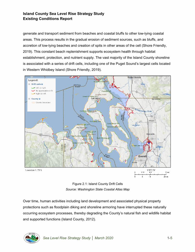
2.1 Ecosystem Processes
The natural movement of water, sediment, and aquatic organisms and their effect on local
ecosystems is perhaps best characterized by the concept of drift cells. Drift cells are coastline
areas for which wind, wave action, and surface and groundwater runoff and freeze/thaw cycles
Island County Sea Level Rise Strategy Study Existing Conditions Report
Sea Level Rise Strategy Study │ March 2020 1-5
generate and transport sediment from beaches and coastal bluffs to other low-lying coastal
areas. This process results in the gradual erosion of sediment sources, such as bluffs, and
accretion of low-lying beaches and creation of spits in other areas of the cell (Shore Friendly,
2019). This constant beach replenishment supports ecosystem health through habitat
establishment, protection, and nutrient supply. The vast majority of the Island County shoreline
is associated with a series of drift cells, including one of the Puget Sound’s largest cells located
in Western Whidbey Island (Shore Friendly, 2019).
Figure 2.1: Island County Drift Cells
Source: Washington State Coastal Atlas Map
Over time, human activities including land development and associated physical property
protections such as floodplain diking and shoreline armoring have interrupted these naturally
occurring ecosystem processes, thereby degrading the County’s natural fish and wildlife habitat
and supported functions (Island County, 2012).

Island County Sea Level Rise Strategy Study Existing Conditions Report
Sea Level Rise Strategy Study │ March 2020 1-6
2.2 Climate
Precipitation and wind are primary areas of climate influence along Island County shorelines.
Annual precipitation between 17-40 inches per year is the primary source of recharge for
freshwater aquifers, which provide the majority of the County’s potable water. Maintaining
adequate water supply of potable quality is a key function of these aquifers, and their ability to
perform this function is largely dependent on precipitation and managed water consumption.
Wind contributes significantly to coastal erosion along Whidbey Island’s western shoreline and
wave action throughout the County. Changing dominant winds from the south-southwest in the
fall through winter months, and from the north in the late spring and summer influence the
coastal landscape and activities throughout the County (Island County, 2012).
2.3 Geology and Shore Landforms
Island County’s shoreline natural landforms, or “shoreforms,” consist primarily of beaches and
bluffs created from glacial deposits and barrier beaches fed by sediment from eroding bluffs
(Island County, 2012). Bluff erosion is a natural and continuous process which results in varying
rates of gradual shoreline retreat and volume loss throughout the County. In many cases, the
erosion process increases the risk of coastal landslides, most recently and vividly exemplified by
the 2013 Ledgewood/Bonair landslide on Whidbey Island’s western shoreline (Island County,
2013).
Figure 2.2: Ledgewood/Bonair Slide (Whidbey Island)
Source: Island County Department of Emergency Management

Island County Sea Level Rise Strategy Study Existing Conditions Report
Sea Level Rise Strategy Study │ March 2020 1-7
Artificial shoreforms such as bulkheads and dredged channels comprise approximately 4.5% of
the overall county shoreline, with a significantly higher occurrence on West Whidbey Island
(11.8%) than East Whidbey (3.7%) or Camano Island (0.3%). Despite seemingly high
percentages on Whidbey Island, the county’s overall artificial shoreline is considered low in
comparison with other Puget Sound shorelines (Island County, 2012).
2.4 Surface and Groundwater
Island County’s surface water features include a series of small lakes and streams which collect
and convey surface storm water runoff from multiple, relatively small drainage basins. Though
much of the precipitation which falls throughout the county is infiltrated into surrounding soils,
heavy rainfall events result in excess runoff which eventually reaches the shoreline, contributing
to coastal erosion. Island County aquifers provide potable water for 72% of Island County
residents and vary in depth and composition. Approximately 20-34% of annual rainfall, or 22
billion gallons of water, are estimated available for aquifer recharge, significantly exceeding
current consumer demand. Despite this abundance, issues such as seawater intrusion and
introduction of surface contaminants in high permeability soils are primary concerns related to
quantity and quality of groundwater available in coastal aquifers (Island County, 2012).
2.5 Fish & Wildlife Habitat
The Island County shoreline boasts diversity in terms of habitat type and supported species, the
success of which is largely influenced by the amount of human disturbance. Island County
coastal fish, invertebrate, amphibian, bird, and mammal habitat identified in the 2012 Shoreline
Master Program includes: beaches, tidal flats, kelp and eelgrass, marshes, freshwater wetlands,
marine riparian zones, and streams (Island County, 2012). Many of these areas support fish and
wildlife species listed as threatened or endangered under federal, state, or both designations.
Descriptions of each habitat type and examples of supported species are detailed in the SMP
and summarized below.
Pocket and barrier beach habitat consists of unconsolidated sediment which moves with tidal
action. This habitat supports shorebirds and mammals including Black Turnstone and River
Otter; shellfish such as the Geoduck Clam; and forage fish such as the Sandlance.

Island County Sea Level Rise Strategy Study Existing Conditions Report
Sea Level Rise Strategy Study │ March 2020 1-8
Tidal flats consist of unconsolidated sand and/or mud in intertidal and subtidal areas. This
habitat supports shellfish and invertebrates such as little-neck clams and Dungeness crabs;
shorebirds and wading birds including Dunlin and Great-Blue Heron; and mammals and birds
such as raccoon, bald eagle, and glaucous-winged gulls.
Kelp forests and eelgrass meadows form in lower intertidal and subtidal zones and provide
habitat for invertebrates which serve as a primary food source for various fish species, including
salmonids. Sea birds such as the Red-throated Loon, Western Grebe, and Marbled Murrelet
rely on these areas as foraging grounds as well.
Salt and brackish marshes occur in areas of tidal inundation, and provide juvenile salmonid
habitat, as well as support for multiple species of songbirds, mammals, and predatory birds
such as bald eagles and ospreys.
Freshwater wetlands often lie in depressions adjacent to coastal areas and provide nesting
and foraging habitat for waterfowl such as Green-Winged Teal; amphibians including the Pacific
Tree Frog; and birds and mammals transitioning the area such as black-tailed deer, barred
owls, and raccoons.
Marine riparian forests along coastal bluffs consist primarily of western hemlock, Douglas fir,
western red cedar, shore pine, and grand fir. These forests provide year-round nesting and
foraging habitat and movement corridors for bird species such as the black-capped chickadee.
Adjacent bluff faces provide nesting and foraging habitat for other bird species including Bank
Swallow, Belted Kingfisher, and Peregrine Falcons.
Streams that drain to the Island County shoreline are often surrounded by riparian and wetland
habitats which support numerous bird, mammal, and amphibian species. The streams
themselves directly support various salmonids and other fish, as well as invertebrates such as
crawfish.
2.6 Shoreline Land Use and Residential Development
Predominant land uses along the Island County shoreline include residential development,
designated tidelands, and agriculture (Island County, 2012). Other uses include parks and open
space, limited commercial development, and forest or timber. The Island County Shoreline

Island County Sea Level Rise Strategy Study Existing Conditions Report
Sea Level Rise Strategy Study │ March 2020 1-9
Master Program categorizes allowable land use into a series of Shoreline Environmental
Designations, presented in the figure below.
Figure 2.3: Island County Shoreline Environmental Designation Map
Source: Island County Shoreline Master Program, 2012

Island County Sea Level Rise Strategy Study Existing Conditions Report
Sea Level Rise Strategy Study │ March 2020 1-10
Approximately 63% of the Island County shoreline is designated for residential land use and
presented above as Rural Conservancy or Shoreline Residential environmental designations.
The Rural Conservancy designation includes areas zoned as “Rural,” which accounts for 49% of
the shoreline and allows 5-acre minimum residential lots. The Shoreline Residential designation
includes areas zoned as “Rural Residential,” which comprise 14% of the shoreline and allow for
smaller (0.3-2.5 acre) residential lot development. The remaining shoreline land uses primarily
fall under Natural or Aquatic environmental designations. Exceptions include limited high
intensity and urban conservancy environments at and immediately adjacent to Central and
South Whidbey Island ferry terminals and shipbuilding businesses.
Island County Shoreline Residential development is the focus of this report and is most
commonly encountered in the form of historic beach communities, canal communities, and
coastal (feeder) bluff communities. These communities are characterized by their physical
relationship to the shoreline and predominant development patterns. In each case, specific
regulations governing future development apply. These regulations include designation of
marine buffers which preclude most development and support critical species habitat and
ecosystem process restoration; and shoreline setbacks which limit allowable development
directly adjacent to the shoreline. Specific characteristics of these three community types and
applicable development limitations are detailed in this section.
2.6.1 Historic Beach Communities
Historic Beach Communities consist of densely platted small lots with residential structures
constructed thirty feet or less from the ordinary high water mark. These properties were
established prior to Washington State’s adoption of the Shoreline Management Act (SMA) in
1972. According to Island County Shoreline Master Program guidance for homeowners, Historic
Beach Community designations allow for residential development and moderate-to high-impact
recreational uses which reflect historic development patterns and consider normal shoreline
ecosystem functions in appropriate areas of the shoreline. These communities are located
primarily along beaches and spits formed by sediment accretion over time.

Island County Sea Level Rise Strategy Study Existing Conditions Report
Sea Level Rise Strategy Study │ March 2020 1-11
Figure 2.4: Historic Beach Community Example
Source: Island County SMP Guidance
Historic Beach Community
development standards include a
minimum 20-foot marine buffer from the
ordinary high water mark and an
additional 10-foot shoreline setback.
Landscaping and development within
these buffers and setbacks are
regulated under provisions of the Island
County Shoreline Master Program.
2.6.2 Canal Communities
Canal Communities consist of discrete residential communities developed along engineered
canals. These communities are typified by residential structures constructed above the ordinary
high water mark with dedicated waterfront access. Canal Communities are primarily located in
Marine Buffer and Setback Requirements

Island County Sea Level Rise Strategy Study Existing Conditions Report
Sea Level Rise Strategy Study │ March 2020 1-12
areas formed by sediment accretion in which lagoons were dredged to form canals and dredged
material was used to create adjacent developable land.
Figure 2.5: Canal Community Example
Source: Island County SMP Guidance
Island County development regulations
require a 40-foot shoreline setback from
the ordinary high water mark.
Landscaping and development within
these buffers and setbacks are
regulated under provisions of the Island
County Shoreline Master Program.
2.6.3 Coastal (Feeder) Bluff Communities
Coastal (Feeder) Bluff communities, consist of residential development both atop and at the
base of steep or unstable slopes. Bluffs adjacent to these communities are identified as drift cell
sediment sources, which are subject to erosion as part of natural coastal ecosystem processes.
Marine Buffer and Setback Requirements

Island County Sea Level Rise Strategy Study Existing Conditions Report
Sea Level Rise Strategy Study │ March 2020 1-13
Figure 2.6: Coastal (Feeder) Bluff Community Example
Source: Washington State Coastal Atlas Map
These communities generally fall under the Shoreline Residential designation, though they may
overlap with Rural Conservancy shoreline environmental designation. Steep unstable slopes
also exist throughout Natural shoreline environmental designations; however, development in
these areas is typically sparse and not characteristic of communities evaluated in this report.
Regulations applicable to Shoreline Residential development include a 30-foot marine buffer
and additional 45-foot shoreline setback at the base of bluffs; and an additional 50-foot steep
slope buffer for development on the top of bluffs.
Community Marine Buffer and Setback Requirements Source: SMP Guidance for Island County Homeowners

Island County Sea Level Rise Strategy Study Existing Conditions Report
Sea Level Rise Strategy Study │ March 2020 1-14
3. Community Coastal Flooding Concerns
Since 1990, Island County has experienced eight extreme flooding events resulting in disaster
declarations (Island County, 2015). In coastal areas, extreme flooding events typically occur as
a result of combined severe winter storms and tidal surge. Island County coastal communities
are particularly vulnerable during these events, as they are often impacted by both erosion
resulting from surface water runoff, and the effects of tidal surge. County staff review of damage
associated with historical flooding events, community input gathered during recent countywide
projected sea level rise forums, and Island County staff input collected through interviews
highlight the following community concerns related to extreme coastal flooding events:
3.1 Private Property Impacts
Historic Beach, Canal, and Coastal Bluff communities are particularly susceptible to private
property damage during extreme flooding events. Reported damages from previous flooding
events include overtopping of bulkheads, inundation and failure of onsite septic systems and/or
groundwater wells, residential ground floor flooding, restricted private beach access, and
protracted site drainage precluding timely repair. These issues lead to costly and time-
consuming repairs and, in some cases, temporary displacement of community members.
County and community input indicate shared concern that existing regulatory mechanisms such
as development permitting and flood insurance guidelines do not adequately mitigate hazards
associated with these events, and instead may lead property owners to pursue individual
protections rather than whole community resilience. Island County residential development
permitting for homes built in frequently flooded areas reflect the minimum elevation and flood
protection measures necessary to remain eligible for federal flood insurance coverage. Nature-
based adaptation strategies are advocated for in shoreline development guidance; however,
limited incentive for homeowner selection of alternatives to hard protection measures such as
bulkheads exists. Further, an expedited emergency repair permitting process exists for
homeowners who sustained damage from coastal flooding events which, while beneficial in
terms of addressing immediate needs, do not necessarily encourage or facilitate long-term
resilience planning. Though additional permitting requirements apply to shoreline projects
exceeding the “substantial development” threshold of $7,047, without substantial incentive for
nature-based adaptation homeowners may seek to leverage expedited emergency permitting to
re-establish a baseline property flood risk, rather than working toward mitigation and improved

Island County Sea Level Rise Strategy Study Existing Conditions Report
Sea Level Rise Strategy Study │ March 2020 1-15
resilience. County records of emergency repair permit applications and community feedback
during sea level rise forums indicate many private property owners pursue emergency repairs
and improved physical protection of their existing properties through such actions as bulkhead
extensions or dike improvements in response to extreme flooding events; though nature-based
alternatives to shoreline protection including bulkhead removal and natural shore restoration are
gaining popularity.
3.2 Public Property Impacts
Impacts of extreme coastal flooding events extend beyond privately owned property, affecting
public property and natural resources. Island County staff input indicates past flooding events
have contributed to natural resource degradation through release of contaminants into public
waterways and fish and wildlife habitat; interrupted natural ecosystem processes through
diversion of floodwater and associated wave energy to unprotected shorelines; and negatively
impacted public access to shoreline recreation opportunities.
County concerns associated with continuation of existing levels of natural resource degradation
and interruption of ecological processes include the potential for contaminant releases from
onsite septic systems, creosote soaked piles in tidal areas, and household hazardous waste at
a level significant enough to cause long term, irreversible damage to the surrounding ecosystem
and its ability to support regional fish and wildlife; reduction in groundwater supply due to
seawater intrusion and/or flooding of well sites; unnatural erosion patterns with potential to
disproportionately damage public lands; and reduction of fish and wildlife habitat, particularly for
threatened or endangered species. Further, County staff and private property owners alike
expressed concern over potential impacts to public spaces in low-lying coastal areas; both from
the perspective of resource reduction and concern over increased trespassing on private beach
property which may be associated with loss of public amenity.
4. Projected Sea Level Rise Impacts
Sea level rise is one of the most observable impacts of climate change. Two main factors
contribute to global sea level rise. “A warming climate causes global sea level to rise principally
by (1) warming the oceans, which causes seawater to expand, increasing ocean volume, and
(2) melting land ice, which transfers water to the ocean.” (National Research Council, 2012)
From studying Earth’s history, scientists have projected levels rising “another 1 to 4 feet by

Island County Sea Level Rise Strategy Study Existing Conditions Report
Sea Level Rise Strategy Study │ March 2020 1-16
2100.” (NASA, 2019) Those numbers alone are enough to inundate “many cities along the U.S.
East Coast.” (Nunez, 2019)
Current projections indicate sea level rise between 1-3 ft. along the Island County shoreline by
2100 (Miller et al., 2018). Potential impacts to shoreline properties and surrounding ecosystems
include increased coastal flooding, habitat loss, surface and groundwater salinity changes, and
altered coastal erosion and sediment deposition patterns (Miller et al., 2018). How these
impacts might affect Island County is detailed in this section.
4.1 Coastal Flooding
Current flooding problems will only be exacerbated with increases in sea level rise compounded
by storm surge and wave run-up (Miller et al., 2019). The impacts of sea level rise in
Washington State will likely be experienced initially as changes in the magnitude and frequency
of extreme coastal water level events. New areas will be flooded during the most extreme
events, and coastal areas already exposed to flooding will be impacted more frequently
(Vitousek et al., 2017). The combination of sea level rise and extreme storm events will
continue to result in more consistent and severe coastal flooding causing damage to
infrastructure and potential loss of life.
4.2 Habitat Loss
As sea level increases, intertidal habitats like wetlands, mudflats, and marshes are in danger of
disappearing. Human development regularly takes place along the coast and will block intertidal
habitats from their natural response to this phenomenon; expanding inland. Estuaries and
wetlands provide many essential services to communities and will be heavily impacted by sea
level rise. Estuaries, mudflats, and marshes provide “refuge and forage for wildlife, fish, and
invertebrates” and vegetation in these areas “provide overwintering habitat for millions of
migratory waterfowl.” (National Research Council, 2012). These wetland zones buffer sediment
from waterways and streams from moving into the ocean and also protect communities by
storing floodwaters and limiting storm surge. In many cases, sea level rise will submerge these
habitats.

Island County Sea Level Rise Strategy Study Existing Conditions Report
Sea Level Rise Strategy Study │ March 2020 1-17
4.3 Salinity Changes
Higher sea levels will cause an increase in groundwater levels which impacts freshwater
resources. This causes saltwater intrusion in wells, septic system leaching and harms
vegetation. In addition to sea level rise, “groundwater in coastal regions of the US is particularly
at risk due to a combination of changes in precipitation, withdrawal rates. As sea level rises, the
amount of saltwater infiltrating the groundwater aquifer will increase, which can make the water
too salty for human consumption.” (Bradford, 2019) The overall impact is a reduction in water
quality and soil stability. As of late 2019, many Island County residents rely on well water and
septic systems for their freshwater and waste disposal needs.
4.4 Coastal Erosion & Deposition
Finally, rising sea levels will erode land in some areas and grow land through sediment
deposition in others. Beaches and soft cliffs will be most vulnerable to erosion, but this process
will also contribute to habitat loss in estuaries and wetlands. Many Island County residents live
along the coast. Erosion and sea level rise could result in damage to their homes and
properties. On a larger scale, community infrastructure will most likely be impacted including
roads, ports, and industry.
The erosion of cliffs and bluffs is not reversible. Although cliff and bluff erosion is a natural
process it has sped up due to sea level rise. The principal forces catalyzing cliff and bluff
erosion include “marine processes—primarily wave energy and impact, but also tidal range or
sea level variations—and terrestrial processes, such as rainfall and runoff, groundwater
seepage, and mass movements such as landslides and rockfalls.” (National Research Council,
2012) Increased water levels mean increased wave heights and more wave energy eroding
coastlines. This means an increased rate of cliff retreat.
Beaches naturally grow and shrink seasonally depending on wave climates. “These fluctuations
in beach width are predictable and temporary, and the losses of sand experienced each winter
are normally recovered the following summer… [however] over the long term, rising sea level
will cause landward migration or retreat of beaches.” (National Research Council, 2012)
Beaches will be submerged by rising sea levels and will also be transported offshore through
the deposition process.

Island County Sea Level Rise Strategy Study Existing Conditions Report
Sea Level Rise Strategy Study │ March 2020 1-18
5. Current Sea Level Rise Policy Considerations
Current plans, policies, programs, and processes related to Island County coastal development
include limited consideration of projected sea level rise. Though many plans and programs
acknowledge the need to address projected climate change impacts, and some provide
mechanisms for addressing challenges related to extreme coastal flooding and sea level rise,
current coastal development regulations provide limited enforceable adaptation requirements.
These regulations are largely based on flood zones established by the U.S. Federal Emergency
Management Agency (FEMA) for flood insurance purposes, which are heavily reliant on
historical data and do not include consideration of projected future conditions, including those
associated with sea level rise. This section highlights plans, policies, regulations and programs
which govern and support shoreline development in Island County, and the extent to which sea
level rise is considered in each.
5.1 FEMA National Flood Insurance Program (NFIP)
As part of the National Flood Insurance Program (NFIP), the Federal Emergency Management
Agency (FEMA) provides and periodically updates Flood Insurance Rate Maps (FIRMs) for
jurisdictions located within the 100-year, or 1% annual chance floodplain. Island County FIRMs
were last updated in 2017 and provide a relatively clear and current picture of established flood
zone boundaries and base flood elevations. This data is used by FEMA to develop flood
insurance rates as part of the National Flood Insurance Program. Additionally, Island County
uses FEMA flood zones and base flood elevations as the basis for development regulations
related to structural ground floor elevations and flood protections within established floodplains.
It should be noted the FEMA flood maps are based on historical flooding and do not account for
tidal surge, extreme high tides or projected sea level rise. Communities have the opportunity to
address potential flood impacts exceeding established flood zone boundaries and elevations
through adoption of higher regulatory standards and participation in the Community Rating
System (CRS). CRS participation also provides an opportunity for discounted private property
owner flood insurance rates. Island County does not currently take part in the CRS, and current
development regulations within flood zones are consistent with minimum NFIP eligibility
requirements. Also of note, as of 2019 the County and incorporated areas on Whidbey and
Camano Islands had a combined 988 active NFIP policies relative to approximately 8,250
parcels zoned to allow residential development within the established floodplain (FEMA, 2019;

Island County Sea Level Rise Strategy Study Existing Conditions Report
Sea Level Rise Strategy Study │ March 2020 1-19
Island County, 2020). This low percentage of homeowners covered by NFIP policies indicates
increased risk of property loss without certainty of redevelopment in the future.
5.2 Island County Comprehensive Plan Though Island County’s current comprehensive plan, Island County 2036, identifies frequently
flooded areas as subject to critical areas ordinances and includes a land use policy (LU 6.4)
which requires consideration of flood hazards when establishing density; the plan does not
account for sea level rise projections. Instead, flood hazard areas identified in the plan are
consistent with the FEMA 100-year, or 1% annual chance floodplain.
5.3 Island County Shoreline Master Program (SMP)
The current Island County SMP adopted in 2016 includes climate change and projected sea
level rise considerations in policies related to shoreline use, conservation, and development.
These policies call for accounting for projected sea level rise when evaluating shoreline uses;
monitoring effects of climate change on the marine environment through regular sea level and
pH measurements; and adjusting development standards to increase setbacks and minimum
elevations in areas that could be affected by sea level rise (Island County, 2012). Shoreline
permitting processes and guidance identify location-specific marine buffers and shoreline
setbacks detailed in section 3 of this report which are applicable to coastal properties and
communities and generally consistent with SMP considerations; however, these regulations are
based on existing conditions and do not directly account for projected sea level rise. Further,
regulations identified in the SMP favor natural shoreline protections by requiring new
development to “minimize or prevent the need for shoreline defense and stabilization measures
and flood protection works” (17.05A.090.A.13); limiting structural flood reduction measures
(dikes, levees, bulkheads, etc.) to areas where non-structural methods are infeasible
(17.05A.090.L.2); and prohibiting solid waste storage and new or expanding development or
use which would “likely require structural flood control works” (17.05A.090.L.7); among other
significant shoreline protections intended to limit armoring, incompatible shoreline development,
and shoreline ecosystem damage.
5.4 Hazard Mitigation Plan (HMP)
The Island County Multi-Jurisdictional Hazard Mitigation Plan (HMP) identifies hazards and
mitigation opportunities and recommendations related to coastal erosion, dam failure, drought,

Island County Sea Level Rise Strategy Study Existing Conditions Report
Sea Level Rise Strategy Study │ March 2020 1-20
earthquake, flood, landslide, tsunami, volcano, severe weather, and wildfire hazards each
specifically address potential climate change impacts and considerations. The plan includes an
extensive section related to coastal flood hazards which includes critical asset inventories,
vulnerable population identification, and a history of extreme flooding events. According to the
plan, approximately $590 million in private property assets and 11 critical infrastructure systems
are located within the Island County 100-year floodplain. Vulnerable populations within the
floodplain are identified as those over the age of 65 and the economically disadvantaged. This
population totaled 4,168 at the time of the 2015 HMP update.
In terms of coastal resilience considerations, the HMP includes a series of hazard mitigation
recommendations which could support sea level rise adaptation including seeking emergency
management grant funding for acquisition of properties within high-hazard areas and
implementing cost-effective measures to address vulnerability of facilities at risk to sea level
rise, extreme high tides and storm surges as they relate to potential inflow of saltwater (Island
County, 2015). Additionally, the plan calls for improved forecasting, monitoring, and floodplain
management planning to prepare coastal communities for future flood events. Specifically the
plan states: “Going forward, model calibration or statistical relation development must happen
more frequently, new forecast-based tools must be developed, and a standard of practice that
explicitly considers climate change must be adopted;” and “as hydrology changes, what is
currently considered a 100-year flood may strike more often, leaving many communities at
greater risk. Planners will need to factor a new level of safety into the design, operation, and
regulation of flood protection facilities such as dams, floodways, bypass channels, and levees,
as well as the design of local sewers and storm drains” (Island County, 2015).
Though many recommended policies and actions identified in the HMP indicate consideration of
projected sea level rise and intensified coastal flooding events, the plan bases potential flood
impacts on FEMA 100 and 500-year floodplain data which does not account for climate change-
related factors and stops short of recommending specific climate change or sea level rise
adaptation strategies for shoreline properties.
5.5 Island County Development Regulations
The Island County Code of Ordinances includes a chapter which specifically addresses
development in flood hazard areas. Chapter 14.02 Flood Damage Prevention Ordinance
includes general and specific code requirements applicable new development, repair of

Island County Sea Level Rise Strategy Study Existing Conditions Report
Sea Level Rise Strategy Study │ March 2020 1-21
substantial damage, and substantial improvements to structures located within special flood
hazard areas (SFHAs). SFHA development regulations include elevation of the lowest floor of
residential structures to at least the established base flood elevation (BFE), at least three feet
above BFE for critical facilities, and at least one foot above BFE in high hazard areas subject to
high-velocity floodwaters. Base flood elevations are derived from the FEMA flood insurance rate
maps (FIRMs), which, as noted above, are based on periodically updated 100-year floodplain
data and do not account for tidal surge, extreme high tides, or projected sea level rise.
Individual property onsite sewer (septic) system and individual and two-party well permitting
processes are managed by the Island County Department of Environmental Health. Larger
systems require permitting through the Washington Department of Health. County processes
begin with site registration, followed by design submission and permit application, and ultimately
submission of as-built drawings for public record (Island County, 2019). Site approval criteria
accounts for the separation of proposed septic systems from the ordinary high water mark and
viability of well production and groundwater quality at the time of application, but do not
specifically address requirements related to projected sea level rise such as a variable ordinary
high water mark and seawater intrusion into groundwater aquifers. Regular system inspections
are required to ensure compliance with permit criteria and, per feedback from the Department of
Environmental Health, identification of non-compliance may result in a requirement to relocate
septic systems and wells at the homeowner’s cost.
5.6 Natural Resource Conservation and Restoration Programs
The Island County Department of Natural Resources (DNR), in partnership with the Washington
State Department of Natural Resources, Department of Ecology, and Department of Fish and
Wildlife, administers multiple programs designed to address climate change, sea level rise
adaptation, and habitat restoration through community action. Though DNR does not have
permitting authority, programs administered by the Department may benefit development
supportive of conservation efforts. The Island County salmon recovery program is one such
endeavor which seeks to restore and preserve salmon habitat through promotion of “projects
that respect the rights of property owners and create a sustainable environment for people and
fish” (Island County DNR, 2005). Through the salmon recovery program, private property
owners and communities may have access to permitting and funding support for projects which
provide “shore friendly” protection from extreme flooding events and projected sea level rise,

Island County Sea Level Rise Strategy Study Existing Conditions Report
Sea Level Rise Strategy Study │ March 2020 1-22
and result in shoreline and habitat restoration or preservation. To take part in the program and
access this support, private property owners must coordinate applications for grant funding with
Island County DNR submission schedules, and ultimately receive approval through the
Washington State Recreation and Conservation Office Salmon Recovery Funding Board. The
grant process occurs on an annual basis, and landowner application submission criteria and
timelines are managed at the county level (WA Recreation and Conservation Office, 2020).
Another DNR managed program, “Shore Friendly,” is a public education program intended to
“influence Island County shoreline residents who have natural shorelines in place or those who
have armored shoreline and are considering repair/replacement to adopt a ‘shore friendly
protection’ approach” (Shore Friendly, 2019). Recommended “shore friendly protection” includes
replacement of hard armoring such as structural bulkheads with more natural protections
including a combination of increased setbacks, elevated structures; beach nourishment; use of
logs, berms and soft shore material to absorb wave energy; and re-grading of waterfront slopes,
drainage improvements, and planting of resilient native vegetation to reduce erosion potential.
These techniques are consistent with Washington State Department of Ecology soft shore
stabilization guidance as well as recommendations presented in a Washington Department of
Fish and Wildlife 2016 publication, Your Marine Waterfront: A guide to protecting your property
while promoting healthy shorelines (WA Department of Fish and Wildlife, 2016). Implementation
of shore friendly stabilization projects is ultimately governed by provisions of the Island County
SMP and Municipal Code, which the DNR Shore Friendly program seeks to assist interested
property owners in navigating to ensure more resilient communities and nearshore ecosystems.
6. Future Sea Level Rise Policy Considerations Though the majority of existing Island County plans, policies, and processes do not specifically
address potential impacts of projected sea level rise, ongoing and planned updates indicate that
will change. Examples of ongoing and potential State and Island County efforts to account for
projected climate change and sea level rise in future planning, policy and regulation
development processes are summarized below:
● Forthcoming guidance from the Washington State Department of Commerce
recommends comprehensive plan revisions to more specifically incorporate climate

Island County Sea Level Rise Strategy Study Existing Conditions Report
Sea Level Rise Strategy Study │ March 2020 1-23
change and sea level rise adaptation into pertinent elements (WA Department of
Commerce, 2020).
● Island County’s Shoreline Master Program update, which is currently in progress, will
explicitly address sea level rise adaptation best management practices, community-
based coastal resiliency planning, and county-wide monitoring programs (Island County,
2019).
● A 2020 revision to the Island County Hazard Mitigation Plan is underway and will include
updated sea level rise projections as well as specific guidance related to incorporation of
climate change and sea level rise considerations into mitigation strategies.
● Island County may pursue involvement in the FEMA Community Rating System (CRS),
which could reduce shoreline property owner flood insurance rates through
strengthening of development regulations to more adequately address potential impacts
of projected sea level rise.
● Continued development of Department of Natural Resources initiatives such as Salmon
Recovery and Shore Friendly programs may improve permitting processes and access
to financial incentives sufficient to restore Island County natural shorelines while
simultaneously increasing community resilience through the actions of private property
owners and collective communities.
Of these opportunities for incorporation of sea level rise considerations into future Island County
plans, policies, and processes, this report will focus on addressing projected sea level rise as
part of Island County’s 2020 Shoreline Master Program update through identification of
adaptation best management practices and community based coastal resiliency planning.

Island County Sea Level Rise Strategy Study Existing Conditions Report
Sea Level Rise Strategy Study │ March 2020 1-24
References Bradford, Nick. 2019. “Groundwater and the Rising Seas.” National Environmental Education
Foundation. 2019.
Community Attributes, Incorporated. 2019. Island County Economic Trends and Conditions Summary Report: Island County Economic Development Element. https://www.islandcountywa.gov/Planning/Documents/wp_2019/ED/Report-Trends-08-01-19-DRAFT.pdf.
Island County, Washington. (Department of Emergency Management). 2015. lsland County Multi-Jurisdictional Hazard Mitigation Plan. https://www.islandcountywa.gov/DEM/Pages/Hazard-Mitigation-Plan.aspx.
Island County, Washington. (Department of Natural Resources). 2005. Water Resources Inventory Area 6 (Whidbey & Camano Islands) Multi-Species Salmon Recovery Plan. https://www.islandcountywa.gov/Health/DNR/Documents/SalmonRecoveryPlan2005.pdf.
Island County, Washington. (Department of Planning and Community Development). 2012. Shoreline Master Program. https://www.islandcountywa.gov/Planning/pages/shorelines.aspx.
Island County, Washington (Department of Planning and Community Development). 2019. “Island County Shoreline Master Program Update.” Presentation, Island County Marine Resources Committee, Island County, WA, September 28, 2019. https://www.islandcountymrc.org/media/19027/penny-island-county-shoreline-master-program-update.pdf.
Island County, Washington. (Department of Planning and Community Development). “SMP Guidance for Island County Homeowners: Shoreline Residential.” https://www.islandcountywa.gov/Planning/Documents/Shorelines/Homeowner_SED-ShorelineResidential.pdf.
Island County, Washington. “Island County GIS Open Data: FEMA Flood Zones.” Accessed February 23, 2020. https://data-islandcountygis.opendata.arcgis.com/datasets/fema-flood-zones.
Island County, Washington. “Island County GIS Open Data: Parcels.” Accessed February 23, 2020. https://data-islandcountygis.opendata.arcgis.com/datasets/parcels.
Island County, Washington. “Island County GIS Open Data: Zoning.” Accessed February 23, 2020. https://data-islandcountygis.opendata.arcgis.com/datasets/zoning.
Island County, Washington. n.d. Island County Landslides. https://www.islandcountywa.gov/DEM/Documents/landslide.pdf.
Island County Sea Level Rise Strategy Study Existing Conditions Report
Sea Level Rise Strategy Study │ March 2020 1-25
Island County, Washington. Municipal Code of Ordinances: Title VIII, Chapter 8.07D - On-Site Sewage Systems. Accessed February 21, 2020. https://library.municode.com/wa/island_county/codes/code_of_ordinances?nodeId=TITVIIIHEWESA_CH8.07DTESESY.
Island County, Washington. Municipal Code of Ordinances: Title XIV, Chapter 14.02A Flood Damage Protection Ordinance. Accessed February 21, 2020. https://library.municode.com/wa/island_county/codes/code_of_ordinances?nodeId=TITXIVBUCO_CH14.02AFLDAPROR.
Island County, Washington. Municipal Code of Ordinances: Title XVII, Chapter 17.05A – Shoreline Master Program Regulations and Procedures. Accessed February 21, 2020. https://library.municode.com/wa/island_county/codes/code_of_ordinances?nodeId=TITXVIIZO_CH17.05ASHMAPRREPR_17.05A.090SHUSDERE.
Miller, Ian M. 2019. “Sea Level Rise in Washington State: What Is It and Why It’s Happening.” Presentation, Island County Marine Resources Committee, Island County, WA, September 28, 2019. https://www.islandcountymrc.org/media/19026/miller-sea-level-rise-in-washington-state-what-is-it-and-why-its-happening.pdf.
Miller, Ian M., Harriet Morgan, Guillaume Mauger, Tyler Newton, Ray Weldon, David Schmidt, Mark Welch, and Eric Grossman. 2018. Projected Sea Level Rise for Washington State - A 2018 Assessment. A collaboration of Washington Sea Grant, University of Washington Climate Impacts Group, University of Oregon, University of Washington, and US Geological Survey. Prepared for the Washington Coastal Resilience Project. http://www.wacoastalnetwork.com/files/theme/wcrp/SLR-Report-Miller-et-al-2018.pdf
Miller, I.M., Yang, Z., VanArendonk, N., Grossman, E., Mauger, G. S., Morgan, H., 2019. Extreme Coastal Water Level in Washington State: Guidelines to Support Sea Level Rise Planning. A collaboration of Washington Sea Grant, University of Washington Climate Impacts Group, Oregon State University, University of Washington, Pacific Northwest National Laboratory and U.S. Geological Survey. Prepared for the Washington Coastal Resilience Project.
National Aeronautics and Space Administration (NASA). 2019. “Evidence | Facts – Climate Change: Vital Signs of the Planet.” https://climate.nasa.gov/evidence/.
National Research Council. 2012. Sea-Level Rise for the Coasts of California, Oregon, and Washington: Past, Present, and Future. Sea-Level Rise for the Coasts of California, Oregon, and Washington: Past, Present, and Future. National Academies Press. https://doi.org/10.17226/13389.
Nunez, Christina. 2019. “Sea Level Rise, Facts and Information.” National Geographic. 2019. https://www.nationalgeographic.com/environment/global-warming/sea-level-rise/.

Island County Sea Level Rise Strategy Study Existing Conditions Report
Sea Level Rise Strategy Study │ March 2020 1-26
Shore Friendly. 2019. “Resources in Your Area: Island County.” Washington Department of Natural Resources, Washington Department of Fish and Wildlife, U.S. Environmental Protection Agency. http://www.shorefriendly.org/resources/resources-in-your-area/island/.
Shore Friendly. 2019. “Shoreline Ecosystem.” Washington Department of Natural Resources, Washington Department of Fish and Wildlife, U.S. Environmental Protection Agency. http://www.shorefriendly.org/shoreline-ecosystem/#main-3.
U.S. Census Bureau. 2018. Island County, Washington Demographic and housing Estimates. American Community Survey 5-year Estimates. https://data.census.gov/cedsci/table?q=Island%20County,%20Washington&g=0500000US53029&tid=ACSDP5Y2018.DP05&hidePreview=false&vintage=2018&layer=county&cid=DP05_0001E&d=ACS%205-Year%20Estimates%20Data%20Profiles.
U.S. Federal Emergency Management Agency. 2017. National Flood Insurance Program Community Rating System Coordinator’s Manual. OMB No. 1660-0022. https://www.fema.gov/media-library-data/1493905477815-d794671adeed5beab6a6304d8ba0b207/633300_2017_CRS_Coordinators_Manual_508.pdf.
U.S. Federal Emergency Management Agency. 2019. “Policy & Claim Statistics for Flood Insurance.” https://www.fema.gov/policy-claim-statistics-flood-insurance.
Vance-Sherman, Anneliese. 2020. Island County Profile. Washington State Employment Security Department. https://esd.wa.gov/labormarketinfo/county-profiles/island.
Vitousek, S., Barnard, P., Fletcher, C. et al. Doubling of coastal flooding frequency within decades due to sea-level rise. Sci Rep 7, 1399 (2017). https://doi.org/10.1038/s41598-017-01362-7.
Washington State. Department of Commerce. 2020. Growth Management Act Comprehensive Planning for Climate Change - A Guidebook (DRAFT).
Washington State. Department of Ecology. 2017. Shoreline Master Programs Handbook: Appendix A – Addressing Sea Level Rise in Shoreline Master Programs. https://fortress.wa.gov/ecy/publications/parts/1106010part19.pdf.
Washington State. Department of Fish and Wildlife. 2016. Your Marine Waterfront: A guide to protecting your property while promoting healthy shorelines. https://wdfw.wa.gov/sites/default/files/publications/01791/wdfw01791.pdf.
Washington State. Recreation and Conservation Office. 2020. “Salmon Recovery and Puget Sound Acquisition and Restoration.” https://rco.wa.gov/grant/salmon-recovery/.

Sea Level Rise Strategy Study March 2020
Volume 2
Best Practices for Sea Level Rise Adaptation Report

Island County Sea Level Rise Strategy Study Best Practices for Sea Level Rise Adaptation
Sea Level Rise Strategy Study │ March 2020
Table of Contents
1. Introduction 2
1.1 Purpose Statement 2
1.2 Research Question 2
1.3 Document Organization 3
2. Methods 4
2.1 Methodology 4
2.2 Procedure 4
2.3 Data Collection 5
2.2.1 Sea Level Rise Analysis 6
2.3.2 Sea Level Rise Projections for Island County 6
2.3.3 Time Frame, Risk Probability, and Sea Level Rise Projections 7
2.3.4 Best Practices Matrix 8
2.4 Limitations & Further Research 11
3. Literature Review of Available Sea Level Rise Adaptation Tools 13
3.1 Sea Level Rise Adaptation Strategies 13
3.1.1 Strategy: Protect 13
3.1.2 Strategy: Accommodate 15
3.1.3 Strategy: Retreat 16
3.2 Sea Level Rise Adaptation Management Practices 16
3.2.1 Soft Protection Practices 17
3.2.2 Hard Protection Practices 19
3.2.3 Accommodation Practices 25
3.2.4 Retreat Practices 31
3.3 Literature Review Conclusion 32
4. Recommendations 33
4.1 Factors Influencing Recommendations 33
4.2 Adaptation Strategy Considerations for Island County 35
4.3 Adaptation Management Practice Considerations for Island County 35
5. Conclusion 40
References 41
Appendix 2A: Best Practices Matrix 46

Island County Sea Level Rise Strategy Study Best Practices for Sea Level Rise Adaptation
Sea Level Rise Strategy Study │ March 2020 2-1
Executive Summary This study examines available strategies and makes recommendations for three types of
coastal areas in Island County, Washington that are characterized as historic beach, bluff, and
canal communities. The objective of this report is to empower homeowners and neighborhoods
in these communities to know their options when preparing for sea level rise in the future so
they may make choices according to their level of risk tolerance. The literature review contained
in this report acts as a broad overview by evaluating sea level rise adaptation strategies and
practices applicable to individual homeowners and neighborhoods. This information is used in a
cross-comparison analysis of available strategies to those which would be appropriate for Island
County residents to form recommendations. Products of this report include a recommendation
table and analysis matrix which may be informative for Island County coastal homeowners.

Island County Sea Level Rise Strategy Study Best Practices for Sea Level Rise Adaptation
Sea Level Rise Strategy Study │ March 2020 2-2
1. Introduction
Current projections indicate sea level rise between 1-3 ft. along the Island County shoreline by
2100 (Miller et al., 2018). Potential impacts to shoreline properties and surrounding ecosystems
include increased coastal flooding, habitat loss, surface, and groundwater salinity changes, and
altered coastal erosion and sediment deposition patterns (Miller, 2019). In light of the upcoming
challenges, Island County would like to provide information and recommendations to property
owners who will be impacted by the effects of sea level rise.
1.1 Purpose Statement
The purpose of this study is to pinpoint best practices for property owners to use as they
recognize and identify the vulnerabilities of their properties with increased storm and flood
events, determine what might be the options for appropriate adaptation, and choose how to
manage their risk. This best practices report creates a recommendation table of adaptation
practices organized by a time frame of usability and overarching strategy type.
This study uses qualitative methods to examine available strategies and makes
recommendations for three types of at-risk coastal districts on Whidbey and Camano Island:
historic beach, bluff and canal communities.
1.2 Research Question
The goal of this project is to provide information and cultivate greater preparedness for the
impacts of sea level rise to Island County's historic beach communities, canal communities, and
shoreline bluff communities in the form of best practices. To accomplish this we asked what are
homeowner best practices for sea level rise adaptation in Island County, WA on an individual
and neighborhood level?
Best practices will be focused on private assets including:
● Residential structures: setbacks, elevation, etc.
● Septic tanks and drain fields
● Protective structures and devices (bulkheads, bluff retention devices, seawalls, etc.)
● Soft shore armoring
Island County Sea Level Rise Strategy Study Best Practices for Sea Level Rise Adaptation
Sea Level Rise Strategy Study │ March 2020 2-3
● Private wells
● Private drives
Certain questions must be answered to address the central research question. These
supporting questions include:
● What sea level rise adaptation strategies are available?
● How is Island County unique? (Geography, community and other site-specific elements
which could influence adaptation strategy choices)
● What adaptation measures or plans are currently in place in Island County?
● What adaptation measures are appropriate for the three types of communities assessed for
this study (historic beach, bluff, and canal community)?
● Which adaptation measures are appropriate for each planning scenario (short-term, mid-
term, and long-term)?
● What scale can each of these adaptation measures be applied (homeowner, neighborhood,
community-scale)?
● What policies and regulations are in place which could impact sea level rise adaptation
measure decisions?
1.3 Document Organization
This document is organized into seven sections. It begins in Section 1 with an introduction that
broadly discusses the report’s context, purpose and defines the research question. Section 2
focuses on the methods used in the creation of this report including scope, data collection and
analysis, and limitations. Section 2 also includes sea level rise projections for Island County.
Section 3 is comprised of a literature review outlining common sea level rise adaptation
strategies and practices. Section 4 recommends best practices for sea level rise adaptation,
influencing factors to these recommendations and includes a recommendation table. Section 5
concludes the report with a summary of research outcomes and recommendations,
observations on this report’s limitations and suggestions for future research. Document sources
are listed in section 6 and an appendix in section 7.

Island County Sea Level Rise Strategy Study Best Practices for Sea Level Rise Adaptation
Sea Level Rise Strategy Study │ March 2020 2-4
2. Methods
This study uses qualitative methods to examine available strategies and makes
recommendations for three coastal areas on Whidbey and Camano Island. A qualitative
research design was chosen for its open-ended and observation focused analysis style and
ability to address emerging issues. This process included interviews, evaluation of adaptation
best practices in similar communities and document review.
2.1 Methodology
This report uses case studies, a common qualitative methods approach where a “researcher
develops an in-depth analysis of a case, often a program, event, activity, process or one or
more individuals… bounded by time and activity, and researchers collect detailed information
using a variety of data collection procedures over a sustained person of time.” (Creswell, 14)
Sea level rise is one of these emerging questions. As of early 2020 most available English
literature relating to sea level rise has been published within the last ten years.
2.2 Procedure
The research was conducted first by assessing the Island County community and local
government concerns related to extreme coastal flooding and projected sea level rise in an
existing conditions summary. (Please refer to Volume 1 of this report.) Next, the available
literature and case-study information were reviewed to identify best practices in sea level rise
strategies adaptation implemented in communities with similar shoreline characteristics and
coastal resilience goals. Information was consolidated in a matrix for analysis. Finally, sea level
rise adaptation best practices specific to Island County were developed through a cross-
comparison between literature and case-study outcomes and Island County planning objectives.

Island County Sea Level Rise Strategy Study Best Practices for Sea Level Rise Adaptation
Sea Level Rise Strategy Study │ March 2020 2-5
Figure 1. A diagram of the sea level rise adaptation strategy research process.
2.3 Data Collection
Data used to assess existing conditions was obtained through a review of Island County
demographic and economic information; plans, policies, and regulations related to shoreline
development and coastal area management; Island County staff interviews guided by questions
outlined in the appendix; and site visits conducted October 11th and 15th, 2019. Further details
are provided in the Existing Conditions Summary.
A review of existing literature provided information about sea level rise adaptation tools and
processes. The literature review included the historical application of sea level rise adaptation,
as well as published sea level rise adaptation processes and publicly available planning tools
designed to address coastal resilience and climate change adaptation.
In addition, the data collection process required analysis and interpretation of sea level rise
projections for Island County developed as part of the 2018 Projected Sea Level Rise for
Washington, a 2018 Assessment by Miller et.al.

Island County Sea Level Rise Strategy Study Best Practices for Sea Level Rise Adaptation
Sea Level Rise Strategy Study │ March 2020 2-6
2.2.1 Sea Level Rise Analysis
To analyze potential adaptation measures for Island County required identification of sea level
rise projections for the area. This analysis, based upon Miller et al. 2018, takes into
consideration both time frames and probabilities that sea level will meet or exceed a certain
level. The following section describes how to interpret sea level projections developed for
Washington State in 2018 and how to apply that information to the development of
recommendations for adaptation strategies for homeowners.
2.3.2 Sea Level Rise Projections for Island County
The subsequent tables illustrate sea level rise projections for Island County. These projections
are based upon the analysis of Miller, et al. 2018 with the actual projections for Island County
found on the Coastal Hazards Resilience Network (CHRN) website.1 There are 13 different sets
of projections covering different locations throughout Island County. These projections have
been averaged to create this table which can be used for planning purposes. (Please see Figure
2.) However, any site-specific design should not rely upon these numbers. Projections for the
specific location should be applied using the information found on the CHRN website.
Figure 2. Island County sea level rise projections in feet from the 2018 Miller et al. report.
The two tables shown in Figure 2 above, represent two different greenhouse gas (GHG)
1 http://www.wacoastalnetwork.com/wcrp-documents.html

Island County Sea Level Rise Strategy Study Best Practices for Sea Level Rise Adaptation
Sea Level Rise Strategy Study │ March 2020 2-7
scenarios, Representative Concentration Pathway (RCP) or RCP 4.5 and RCP 8.5. These
scenarios affect how quickly the earth warms, and thus how quickly the sea level rises. RCP 4.5
is a low GHG scenario and therefore a slower rate of sea level rise to a lower amount by 2100.
This relates to the release of a reduced amount of greenhouse gas emissions into the
atmosphere. RCP 8.5 is a high GHG scenario and therefore a faster rate of sea level rise to a
higher amount by 2100. This relates to a “business as usual” approach to the release of
greenhouse gases. However, sea level rise for the two scenarios is essentially the same
through 2050 because warming until mid-century is primarily due to past emissions.
For the purpose of this study, RCP 8.5 was chosen to make recommendations for Island County
representing business as usual conditions. As of February 2020, it seems unlikely that GHG
emissions will be reduced in the immediate future to warrant planning for RCP 4.5 based on
current global trends.
Figure 3. Island County sea level rise projections from the 2018 Miller et al. report in feet
showing the GHG scenario and projections table utilized for this report.
2.3.3 Time Frame, Risk Probability, and Sea Level Rise Projections
For each of the two tables in Figure 3, the projections are developed based upon time and level

Island County Sea Level Rise Strategy Study Best Practices for Sea Level Rise Adaptation
Sea Level Rise Strategy Study │ March 2020 2-8
of acceptable risk. The column on the left provides three different time frames for planning
consideration 2050, 2070 and 2100. This allows the user to compare projected rises in sea level
over different times based upon planning horizons or lifespan of a project. In the case of
adaptation measures, the time frame relates to when impacts from sea level rise might reach
certain levels that “trigger” the need to take action or reflect the best type of approach to
adapting to a certain elevation of projected sea level.
The row across the top allows the user to select a probability that sea levels will reach or
exceed a given amount of sea level. For example, the “very likely” column of numbers relates to
the high probability (95%) that sea level will exceed the numbers shown on the table for any
time frame in that column. By contrast, the “unlikely” column provides numbers where it is highly
unlikely (1%), although possible, that sea levels would reach that number at any time frame
shown.
Using the two different GHG tables, RCP 4.5 and RCP 8.5, it is possible to see after 2050 how
sea level rise projections are different and thus requires a decision about which set of
projections to use. For example, in the RCP 4.5 scenario (the top table in Figure 3) there is a
very likely chance, or over 95% probability, that sea levels will rise 0.3 feet by 2050, 0.5 feet by
2070 and 0.7 feet by 2100. By contrast, in the RCP 8.5 table (the lower table in Figure 3) there
is a very likely chance, or over 95% probability, that sea levels will rise 0.3 feet by 2050, 0.6 feet
by 2070 and 1 foot by 2100.
2.3.4 Best Practices Matrix
The literature review provided information about management practices applicable to each of
the three adaptation strategies (protect, accommodate, retreat). A matrix was created to identify
relevant variables in short form which could be compared to site-specific requirements of the
three neighborhood typologies and key indicators in Island County resulting in sea level rise
practice recommendations.
This matrix includes a list of common sea level rise adaptation strategies broken down into the
three categories recommended by the International Panel on Climate Change (IPCC): protect,
accommodate, and retreat. Each strategy is then subdivided into more specific management

Island County Sea Level Rise Strategy Study Best Practices for Sea Level Rise Adaptation
Sea Level Rise Strategy Study │ March 2020 2-9
practices. Each management practice includes a definition, whether or not the action is
permissible in Island County, a sample project, and links to more information.
This matrix also determines whether each management practice would be applicable in each of
the three Island County communities examined in this report (historic beach, bluff and canal
communities) in the Community Applicability column. This is decided by whether or not a
management practice makes sense when considering generic site conditions of the community
typologies. Additionally, this report takes into account foreseeable impacts these practices might
have in these types of locations. If the practice passes this review it will be represented in the
matrix by H for historic beach, B for bluff and C for canal community.
What time frame management practices would be most effectively deployed in was also
considered in the matrix. Time frame is split into three options: short-term representing today
through the year 2050, mid-term representing 2050 to 2070 and long-term representing 2070 -
2100. These ranges correspond to the sea level rise projection tables seen in Figure 3. These
factors are shown in the matrix’s Time Frame column and are shown with S for short-term, M for
mid-term, and L for long-term.
The following table was compiled to link the time frame designations used by this report and the
mid-range sea level rise anticipated from the projection table RCP 8.5.
Time Frame Time Range Mid-Range Sea Level Rise Anticipated
Short-term Now - 2050 0.5 - 1.0’
Mid-term 2050 - 2070 0.9 - 1.7’
Long-term 2070 - 2100 1.5 - 3.0’
Figure 4. Table relating time frame used in this report’s recommendations to specific years and
projected sea level rise in feet from RCP 8.5 via Miller et al.

Island County Sea Level Rise Strategy Study Best Practices for Sea Level Rise Adaptation
Sea Level Rise Strategy Study │ March 2020 2-10
The scale of the adaptation management practices is also denoted in the matrix in the Scale
column. This speaks to in general terms how many households may be necessary to deploy a
type of management practice. Some practices, like installing a floodwall or temporary barrier,
could be used by an individual homeowner (represented in the matrix by I), a small group of
neighbors (represented by G), or a neighborhood (represented by N).
While all options for adaptation practices are discussed in the literature review, practices not
viable for use in Island County were removed from the matrix. This analysis matrix is meant to
be available as a quick reference tool that may operate independently from this report.
A sample of this matrix can be seen in Figure 5 below and may also be found in its final form in
this report’s Appendix.
Strategy Practice Description
Community Applicability H - Historic Beach B - Coastal Bluff C - Canal
Time Frame S - Short-term M - Mid-term L - Long-term
Permissibility P - permitted X - prohibited C - conditional SED - shoreline environmental designation
Scale I - Individual Homeowner S - Small Groups N - Neighborhood
Example+ Location Link
Figure 5. Example of Best Practices Analysis Matrix not yet filled in.
Using the information from this analysis matrix, this report recommends sea level rise
adaptation management practices for the three Island County community typologies: historic
beach, bluff and canal communities. Recommendations are presented in a recommendations
table. This table includes the specific management actions listed for each of the overall
adaptation strategies and determines which ones apply based upon the type of community and
time frame.
The sea level rise adaptation practice recommendation table is found in the recommendations
portion of this report and the Appendix. A draft of this table is also shown in Figure 6.

Island County Sea Level Rise Strategy Study Best Practices for Sea Level Rise Adaptation
Sea Level Rise Strategy Study │ March 2020 2-11
PROTECT ACCOMMODATE RETREAT
SHORT-TERM STRATEGIES (Now - 2050)
MID-TERM STRATEGIES (2050 - 2070)
LONG-TERM STRATEGIES (2070 - 2100)
Figure 6. Example of Practices Recommendations Table not yet filled in.
2.4 Limitations & Further Research
Limitations to the research process which may bias or influence outcomes and/or
recommendations include:
Limited community contact: Community contact was limited to two public engagements held
on September 28, 2019, and facilitated by the Island County Marine Resources Committee
(MRC), an advisory group comprised of community volunteers and Island County staff. All other
information related to community issues referenced in this report was obtained through County
staff interviews, which may result in a biased assessment of community issues.
Anecdotal issue identification: Few County and/or community issues and concerns identified
during data collection were supported by documentation. County staff interviews and observed
community feedback at MRC forums informed these issues and related planning objectives,
which also may result in a biased assessment of community objectives.
Limited time frame of precedent monitoring: Sea level rise has yet to occur on the scale
scientists project. Although case studies exist where sea level rise adaptation strategies have

Island County Sea Level Rise Strategy Study Best Practices for Sea Level Rise Adaptation
Sea Level Rise Strategy Study │ March 2020 2-12
been implemented, we have yet to see the long-term effects of these strategies. It is
recommended that Island County monitor sea level rise adaptation projects to assess long-term
success.
Monitoring program uncertainty: Community coastal resilience plan implementation is
partially dependent on a community’s ability to monitor sea level and project sea level rise.
Island County is developing a monitoring program that may influence the planning framework
recommended in this report. Revision of the recommended planning framework proposed in this
report may be necessary to incorporate the monitoring program upon establishment.

Island County Sea Level Rise Strategy Study Best Practices for Sea Level Rise Adaptation
Sea Level Rise Strategy Study │ March 2020 2-13
3. Literature Review of Available Sea Level Rise Adaptation Tools
Best practices around sea level rise are critical for the future of coastal communities. The
purpose of this literature review was to gain an understanding of the range of sea level rise
adaptation strategies and available practices that could be applied in Island County for the three
focus communities. The research found more practices than are included in this report; only
those applicable to homeowners or applied on a community scale and relevant to the geology
and topography of coastal areas within Island County are included.
3.1 Sea Level Rise Adaptation Strategies
This literature review provides foundational knowledge about adaptation strategies and
practices. Adaptation strategies are often broken down into three categories as recommended
by the International Panel on Climate Change: protect, accommodate and retreat. For each of
these overarching strategies, there are more specific management practices. Additionally,
management practices falling under the protection strategy may be further organized by soft
and hard practice types; in some literature, these practices are referred to as green or grey.
3.1.1 Strategy: Protect
“Protection” seeks to control natural systems through hard and soft barriers and reduces sea
level rise impacts in a “zone that would be impacted without protection.” (Zommers & Alverson,
2018) Soft protection practices include developing soft shorelines, dunes, beach nourishment
and floating islands. These measures often have a less adverse environmental impact than hard
strategies. Hard protection practices include seawalls, bulkheads, revetments, floodwalls, dikes
and surge barriers. Hard protection practices are designed to stop and keep out water and
prevent erosion in specific areas completely while soft practices allow more flexibility with where
the water goes.

Island County Sea Level Rise Strategy Study Best Practices for Sea Level Rise Adaptation
Sea Level Rise Strategy Study │ March 2020 2-14
Figure 7. A “protect’ sea level rise strategy diagram.
Source: CoastAdapt Australia, 2019
Soft Protection methods are “green solutions [which] utilize ecological and environmental
principles and practices to provide flood protection, as well as reduce erosion and stabilize
shorelines, while also enhancing habitats and improving aesthetics (as compared to hard
solutions). Often, soft solutions are less expensive than hard solutions and lower in
maintenance, but they are not permanent and are subject to erosion.” (Al, 2018) It should be
remembered that there are no permanent solutions where sea level rise is concerned.
Figure 8. Hard protection measures (left) and soft protection (right) on neighboring
Washington beachfront properties.
Source: Washington Department of Fish & Wildlife, 2016

Island County Sea Level Rise Strategy Study Best Practices for Sea Level Rise Adaptation
Sea Level Rise Strategy Study │ March 2020 2-15
Hard Protection methods are “often developed by civil and environmental engineers, are flood
protection structures that are (almost always) permanent. Hard solutions focus on controlling
flooding and sea level rise... The downside of these projects is their disruption of ecological
systems. They are generally expensive and require maintenance.” (Al, 2018) Hard adaptation
practices may also be referred to as grey protection measures. These protection practices often
use materials like concrete and stone.
Overall, hard protection practices are rigid and often do not adapt well to a changing
environment. They should primarily be considered an adaptation strategy in the near term. The
cost of continually upgrading hard protection will eventually become unsustainable for the
average homeowner. Additionally, hard protection practices may transform the look of a
property and may alter the aesthetic appeal and character of the property if, for example, a
bulkhead is required to be elevated higher and higher to protect against rising seas.
3.1.2 Strategy: Accommodate
“Accommodation” allows natural systems to occur and impacts to humans and development
“are minimized by adjusting human use of the coastal zone via changing land use/crop types,
applying flood resilience measures, etc.” (Zommers & Alverson, 2018) This strategy includes
techniques like elevating structures, floodproofing and floodable designs. This strategy entails
learning to live with rising waters.
Figure 9. An “accommodate” sea level rise strategy diagram.
Source: CoastAdapt Australia, 2019

Island County Sea Level Rise Strategy Study Best Practices for Sea Level Rise Adaptation
Sea Level Rise Strategy Study │ March 2020 2-16
3.1.3 Strategy: Retreat
“Retreat” or “planned retreat” allows natural systems to occur without human intervention.
“Human impacts are minimized by pulling back from the coast via land use planning,
development controls, planned migration, etc.” (Zommers & Alverson, 2018) Retreat is the only
way to entirely eliminate risk to life and property from sea level rise. In some cases, retreat may
be an unavoidable response. However, “this option is economically feasible only if it is possible
to relocate within [an] existing property, either to higher ground or with a greater setback from a
flood source.” (Watson & Adams, 2011) The strategy of retreat may be considered at any time
frame suggested for sea level rise adaptation planning.
Figure 10. A “retreat” sea level rise strategy diagram.
Source: CoastAdapt Australia, 2019
3.2 Sea Level Rise Adaptation Management Practices
The following section goes into detail about specific management practices available for sea
level rise adaptation. Each management practice is organized by which adaptation strategy it
falls under. Protection strategies are also classified by soft and hard practice type. For each
management practice, pros and cons are listed along with environmental considerations and an
example. Links to examples and more information on the following practices are included in the
matrix in this report’s appendix.

Island County Sea Level Rise Strategy Study Best Practices for Sea Level Rise Adaptation
Sea Level Rise Strategy Study │ March 2020 2-17
3.2.1 Soft Protection Practices
Soft Shorelines are highly designed coastal areas that reduce shoreline erosions through the
use of natural materials. They are often “gently sloping natural banks” that “protect coastal
ecosystems, and help reduce storm surge strengths along the coastline.”(Al, 2018) Designers
limit the amount and type of hardscape elements used and emphasize the use of plants and
sands. The goal is to return to or reinforce natural systems along coastlines.
● Pros: Reduce erosion, create habitat, stabilize shorelines, improve coastal resilience,
inexpensive compared to most hard adaptation practices
● Cons: Limited design guidance, not appropriate for high energy environments, a limited
number of knowledgeable and licensed contractors
● Environmental Considerations: Soft shorelines can restore habitat and natural ecological
processes to a site.
● Time Frame: Practice may be used for all of the time frames because of its ability to adapt to
rising seas overtime. However, in the long term, it is possible the site may be too limited in
size to accommodate the ever-shifting shoreline and need to retreat away from flooding
impacts.
● Example site: Olympic Sculpture Park, Seattle, Washington, USA
Figure 11. Softshore installation along Washington beachfront.
Source: Washington Department of Fish & Wildlife, 2016

Island County Sea Level Rise Strategy Study Best Practices for Sea Level Rise Adaptation
Sea Level Rise Strategy Study │ March 2020 2-18
Beach Nourishment is the “replacement or augmentation of beach sand removed by ocean
waters.” (Watson & Adams, 2011) This process may occur naturally or artificially.
● Pros: Protects public and private infrastructure, expands usage by adding area, protects
shore ecosystem, reverses erosion, encourages vegetative growth, increases economic and
recreational opportunities
● Cons: Challenges finding similar beach material which increases project success, new
sediment may bury marine life, limited public access during installation, for success beaches
must have regular re-nourishment
● Environmental Considerations: Beaches can benefit from nourishment practices but the
application covers existing plants and animals.
● Time Frame: Practice may extend the life of a beach being eroded in the short and mid-
term. However, this likely will not be a long term solution as sea level rise is expected to
surpass elevation of existing beaches.
● Example Site: Marine Park, Bellingham, Washington, USA
Figure 12. Beach nourishment in progress.
Source: Western Carolina University, 2018

Island County Sea Level Rise Strategy Study Best Practices for Sea Level Rise Adaptation
Sea Level Rise Strategy Study │ March 2020 2-19
3.2.2 Hard Protection Practices
Bulkheads & Seawalls. Bulkheads are a “wall or other structure, often wood, steel, stone, or
concrete, designed to retain or prevent sliding or erosion of the land. Occasionally bulkheads
are used to protect against wave action.” (Watson & Adams, 2011) Seawalls are extremely
similar to bulkheads and have been consolidated under this category.
● Pros: Reduces the impact of wave action on the substrate, stabilizes shoreline, less
space required for installation, long lifespan, easily repaired
● Cons: Eliminates intertidal zone, erodes seabed and neighboring unreinforced sites,
disrupts natural sediment systems resulting in beach erosion, overtopping may trap
water behind a wall and cause damage, expensive installation costs, increases wave
energy, designed for erosion protection not flooding
● Environmental Considerations: Negatively impacts the environment by eliminating
habitat and speeding erosion around the installation.
● Time Frame: Practice may be effective in the short term but it is likely that the height and
width of the seawall will need to be regularly increased to protect against increased
coastal flooding. Structural integrity and overtopping will be increased concerns as water
levels rise.
● Example Site: The Seawall, Vancouver, Canada
Figure 13. Photo of a bulkhead along Washington’s coast.
Source: Shoreline Construction, 2019
Dikes, Levees & Embankments. A dike is “a constructed wall or embankment along a shore to
prevent flooding of low-lying land.” (Watson & Adams, 2011) Levees are similar to dikes. These

Island County Sea Level Rise Strategy Study Best Practices for Sea Level Rise Adaptation
Sea Level Rise Strategy Study │ March 2020 2-20
structures sometimes have an access road along their top and are made of earth, stone or other
materials. Embankments are a wider version of dikes and levees.
● Pros: Prevents flooding from storm surge and tide fluctuations, manages wave action,
stabilizes the shoreline
● Cons: Changes existing ecological systems, disrupts natural sediment systems
● Environmental Considerations: Negatively impacts the environment by disrupting natural
ecological systems.
● Time Frame: Practice may be effective in the short term but it is likely that the height and
width of the dikes will need to be regularly increased to provide flooding protection.
Structural integrity and overtopping will be increased concerns as water levels rise.
● Example Site: Motorway Dike, Netherlands
Figure 14. Diagram of levees in a residential context.
Source: FEMA, 2015

Island County Sea Level Rise Strategy Study Best Practices for Sea Level Rise Adaptation
Sea Level Rise Strategy Study │ March 2020 2-21
Dry Floodproofing “prevents water from entering a structure through watertight designs.” (Al,
2018) To do this, building walls must be sealed with waterproof coatings, may use impermeable
membranes or an additional layer of masonry or concrete.
● Pros: No additional space needed, maybe funded through FEMA grant programs,
inexpensive compared to other retrofitting methods
● Cons: Structure failure if water velocity and height exceeds dry proofing rating
● Environmental Consideration: Impact unknown
● Time Frame: This practice was designed to protect from temporary flooding and should
be considered as added protection in the event of storm surge, king tides, or other
similar events in the short term and mid-term. The maximum dry floodproof rating is
currently 3 feet.
● Example Site: University of Texas Perimeter Wall and Dry Floodproofing Project,
Houston, Texas, USA
Figure 15. Diagram of dry floodproofing in a residential context.
Source: FEMA, 2015

Island County Sea Level Rise Strategy Study Best Practices for Sea Level Rise Adaptation
Sea Level Rise Strategy Study │ March 2020 2-22
Floodwalls & Temporary Barriers. Floodwalls are “vertical artificial barriers, either temporary
or permanent, designed to withstand waters from a river, waterway or ocean.” (Al, 2018) “A
floodwall can surround a structure or, depending on flood depths, site topography, and design
preferences can protect isolated openings such as doors, windows, and basement entrances,
including entry doors and garage doors.” (FEMA, 2007) Floodwalls are usually used in open
spaces. If floodwalls are temporary, they can be moved and deployed in different locations.
● Pros: Reduces flood risk
● Cons: Large area required, the cost may be prohibitive, can worsen flooding of
neighboring properties
● Environmental Considerations: Permanent flood walls may have a similar effect as
bulkheads and seawalls on the environment, disrupting the natural sediment systems.
● Time Frame: Practice may be effective in the short term but it is likely that the height and
width of the floodwall will need to be regularly increased to protect against coastal
flooding. Structural integrity and overtopping will be increased concerns as water levels
rise.
● Example Site: Mobile Floodwall, Grein, Austria
Figure 16. Diagram of floodwalls in a residential context.
Source: FEMA, 2015

Island County Sea Level Rise Strategy Study Best Practices for Sea Level Rise Adaptation
Sea Level Rise Strategy Study │ March 2020 2-23
Revetment & Riprap. A revetment is “A facing of stone or concrete to protect an embankment
or shore structure against erosion by wave action or currents” or “a retaining wall, typically
sloped.” (Watson & Adams, 2011) These terms often refer to material that is not anchored or
has little anchoring like rocks placed on a beach.
● Pros: Reduces wave action, low maintenance, long-lasting
● Cons: Low flood protection effectiveness, disrupts natural sediment systems, a large
area required, eliminates intertidal habitat, erosion of neighboring sites, increases water
velocity
● Environmental Considerations: Negatively impacts the environment
● Time Frame: This is a short term solution as wave action in addition to increasing sea
level rise will likely cause the failure of revetment and riprap.
● Example Site: Cleveleys Coastal Project, Cleveleys, United Kingdom
Figure 17. Photo of Rialto Spit Revetment Repair project in La Push, WA.
Source: Washington Rock Quarries Inc., 2019
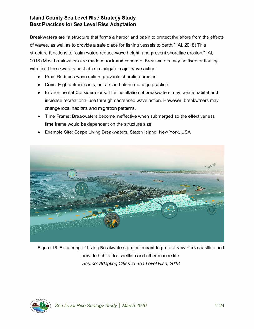
Island County Sea Level Rise Strategy Study Best Practices for Sea Level Rise Adaptation
Sea Level Rise Strategy Study │ March 2020 2-24
Breakwaters are “a structure that forms a harbor and basin to protect the shore from the effects
of waves, as well as to provide a safe place for fishing vessels to berth.” (Al, 2018) This
structure functions to “calm water, reduce wave height, and prevent shoreline erosion.” (Al,
2018) Most breakwaters are made of rock and concrete. Breakwaters may be fixed or floating
with fixed breakwaters best able to mitigate major wave action.
● Pros: Reduces wave action, prevents shoreline erosion
● Cons: High upfront costs, not a stand-alone manage practice
● Environmental Considerations: The installation of breakwaters may create habitat and
increase recreational use through decreased wave action. However, breakwaters may
change local habitats and migration patterns.
● Time Frame: Breakwaters become ineffective when submerged so the effectiveness
time frame would be dependent on the structure size.
● Example Site: Scape Living Breakwaters, Staten Island, New York, USA
Figure 18. Rendering of Living Breakwaters project meant to protect New York coastline and
provide habitat for shellfish and other marine life.
Source: Adapting Cities to Sea Level Rise, 2018

Island County Sea Level Rise Strategy Study Best Practices for Sea Level Rise Adaptation
Sea Level Rise Strategy Study │ March 2020 2-25
3.2.3 Accommodation Practices
Septic System Improvements. As discussed in the existing conditions report, septic systems
pose an increasing risk to public health and the environment as sea levels rise. Two main
improvements may reduce the impact of septic systems. First, advanced septic systems use a
secondary treatment before releasing waste into the leech field and will reduce contaminants
discharged into the environment upon inundation. Second, using concrete blocks or other
anchoring materials to prevent septic systems from floating up from the ground. This procedure
is often called septic system anchoring. Septic systems may also be sealed by placing a
neoprene gasket between the access cover and its seat and bolting down the access cover.
This creates a watertight seal.
● Pros: Protect homeowner infrastructure, reduce environmental impact
● Cons: Expensive upfront cost
● Environmental Considerations: Reduces pollution risk
● Time Frame: Effectiveness of septic improvements depends on the location of the
system on a given property. Septic systems need leach fields in order to operate which
cannot be permenently submerged by sea level rise.
● Additional Information: Rhode Island Coastal Property Guide
Figure 19. Diagram of a sealed septic system.
Source: FEMA, 1999

Island County Sea Level Rise Strategy Study Best Practices for Sea Level Rise Adaptation
Sea Level Rise Strategy Study │ March 2020 2-26
Utility Relocation & Consolidation is an umbrella term for numerous practices that may aid
sea level rise adaptation. On a property, practices may include elevating electrical outlets and
lines to reduce the impacts of flooding. In a neighborhood, relocating freshwater wells upland
may be necessary as saltwater intrusion renders wells inoperable. When relocating a utility consolidation with neighbors could reduce overall costs (e.g. community drain fields, shared
roads & wells).
● Pros: Reduces flood impact on utilities (elevation/relocation), reduces maintenance costs for
individuals (consolidation)
● Cons: Expensive
● Environmental Considerations: Reduces pollution risk
● Time Frame: This group of practices are overall resilience measures that may be deployed
at any time during sea level rise adaptation.
● Additional Information: University of Rhode Island Cooperative Extension, Rhode Island,
USA
Water Supply Diversification reduces the chances of losing access to fresh water through
redundancies. This may also decrease coastal groundwater extraction rates. Diversification
could include on-site recycled water systems (e.g. rainwater catchment or greywater reuse) and
service agreements for increased discharge at upland wells. This is another opportunity for the
consolidation of utilities with neighbors which could reduce overall costs.
● Pros: Increased access to freshwater, more dependable source, decreased groundwater
extraction in the coastal zone
● Cons: Expensive
● Environmental Considerations: Impact unknown
● Time Frame: This group of practices are overall resilience measures that may be
deployed at any time during sea level rise adaptation.
● Additional Information: Sea-Level Rise Impacts on Drinking Water: A Groundwater
Modeling Study, Newmarket, NH, USA

Island County Sea Level Rise Strategy Study Best Practices for Sea Level Rise Adaptation
Sea Level Rise Strategy Study │ March 2020 2-27
Floating Structures are specially designed to “rise and fall with floodwaters.” (Al, 2018) These
homes are designed on a foundation to float when excessive floodwaters are present.
● Pros: Not susceptible to sea level rise or flooding, minimal space needs, minimal
ecological disturbance
● Cons: Expensive design and installation costs
● Environmental Considerations: Impact Unknown
● Time Frame: These structures are meant to float when floodwaters are present but not
enough information is available to determine if they would survive permanent inundation
from sea level rise.
● Example Site: The Float House - Make it Right / Morphosis Architects, New Orleans, LA,
USA
House Boats & Floating Homes. Floating homes are structures built on the water and float like
a boat. They are often permanently moored and towed in by boat after construction. Unlike a
houseboat, floating homes cannot move under their own power.
● Pros: Not susceptible to sea level rise or flooding, minimal space needs
● Cons: Use restricted by permit in many municipalities
● Environmental Considerations: Floating structures cast shade that changes light
conditions in aquatic habitat and may impact natural ecological processes.
● Time Frame: These practices may be utilized at any time frame.
● Example Site: Lake Union, Seattle, WA
Figure 20. Photo of houseboats in Seattle, WA.
Source: Seattle Pi, 2020

Island County Sea Level Rise Strategy Study Best Practices for Sea Level Rise Adaptation
Sea Level Rise Strategy Study │ March 2020 2-28
Floodable Spaces, like floodable plains and squares, is a multipurpose space built next to
water bodies and is allowed to fill with water when flooding occurs.
● Pros: Effective use of space
● Cons: Experimental, possible health risk with polluted floodwaters
● Environmental Considerations: Impact varies based on independent factors including
design, materials and construction methods.
● Time Frame: Floodable spaces are commonly designed to flood temporarily but it is
likely that they could be adjusted to hold water permanently without much challenge. A
floodable space will manage inundation at any time frame.
● Example Site: Cumberland Park, Nashville, TN, USA
Figure 21. Rendering of floodable public space in Copenhagen, Denmark - during summer
months this pond is used as an athletic field.
Source: The Guardian, 2016

Island County Sea Level Rise Strategy Study Best Practices for Sea Level Rise Adaptation
Sea Level Rise Strategy Study │ March 2020 2-29
Raised Ground is a management practice that “invites water to penetrate waterfront districts
while elevating infrastructure such as roads to sustain human use during floods. This technique
provides the opportunity for development for residential, office, hotel, retail, and transit uses.”
(Al, 2018) This practice includes elevating structures. FEMA recommends elevating structures
above base flood elevation (BFE) for this practice to be effective. This places “all or most of vital
building infrastructure... above the flood line.” (Al, 2018)
● Pros: Reduces risk of damage to property, may reduce flood insurance premiums, often
fundable under FEMA grant programs
● Cons: Expensive
● Environmental Considerations: Impact unknown
● Time Frame: Raising structures is a short and possibly mid-term solution. Although a
house could be elevated above projected sea level rise, at a certain point, the utilities for
a house may no longer function (i.e. electricity, water, sewer) and residents may not be
able to access roads in and out of the property.
● Example Site: Perez Art Museum, Miami, FL, USA
Figure 22. Diagram of elevating structure in a residential context.
Source: FEMA, 2015

Island County Sea Level Rise Strategy Study Best Practices for Sea Level Rise Adaptation
Sea Level Rise Strategy Study │ March 2020 2-30
Wet Floodproofing “allows floodwater to enter and leave a structure through designated
openings and thus requires non occupied space.” (Al, 2018) This practice does not protect from
other hazards related to floodings like the force of water, erosion and floating debris. The
various types of floodproofing are commonly recommended by FEMA.
● Pros: Allowing water to enter reduces the risk of structures floating off foundations
● Cons: Area must remain unused, floodwaters carry contaminants that may be transferred to
floodable areas
● Environmental Considerations: Impact unknown
● Time Frame: This practice was designed to protect from temporary flooding and should be
considered as added protection in the event of storm surge, king tides, or other similar
events in the short and mid-term.
● Example Site: Burham Hall, Lincoln, VT, USA
Figure 23. Diagram of wet floodproofing in a residential context.
Source: FEMA, 2015

Island County Sea Level Rise Strategy Study Best Practices for Sea Level Rise Adaptation
Sea Level Rise Strategy Study │ March 2020 2-31
3.2.4 Retreat Practices
On-Site Retreat involves relocating structures and other important property elements upland
away from flood risk but remaining within an existing property.
● Pros: Reduces flood risk
● Cons: Expensive
● Environmental Considerations: Impact varies based on independent factors including
design, materials and construction methods. This process may allow more room for habitat if
accompanied by removal of hard protection practices.
● Time Frame: The effectiveness of this management practice is extremely site-specific and
depends on the parcel size and elevation and ability to relocate the structure and associated
utilities.
● Additional Information: Rhode Island Coastal Property Guide, Rhode Island, USA
Figure 24. Photo of a building being moved back from the coastline performed by DB Davis
Structural Moving & Raising Company.
Source: Island County Department of Natural Resources, 2019.

Island County Sea Level Rise Strategy Study Best Practices for Sea Level Rise Adaptation
Sea Level Rise Strategy Study │ March 2020 2-32
Off-Site Retreat entails relocating upland away from flood risk to a different property.
● Pros: Reduces risk of coastal flooding
● Cons: Expensive
● Environmental Considerations: Impact varies based on independent factors including
design, materials and construction methods. This process may allow more room for habitat
if accompanied by removal of hard protection practices.
● Time Frame: This practice may be used at any time but most likely will not be until later as it
requires a large upfront cost.
● Example Site: Managed Retreat at Surfer’s Point, Ventura Beach, CA, USA
3.3 Literature Review Conclusion
An abundance of information exists regarding sea level rise adaptation strategies and
management practices. Although other strategies and practices exist, protect, accommodate
and retreat are the primary adaptation strategies mentioned in available resources examined by
this report. Adaptation management practices reviewed were limited to those feasible for
homeowners and neighborhoods to tackle without government instigation. This topic would
benefit from future research into costs associated with adaptation practices as not much
information was available besides general claims that a practice was ‘expensive’ to implement
or maintain.

Island County Sea Level Rise Strategy Study Best Practices for Sea Level Rise Adaptation
Sea Level Rise Strategy Study │ March 2020 2-33
4. Recommendations
4.1 Factors Influencing Recommendations
A review of literature and analysis of Island County three beach community types led to the
creation of a matrix of best practices applicable to each type of community. The matrix (in the
Appendix) has been summarized into a set of recommended best practices for sea level rise
management practices identified by the overall strategy and time frame. Four key factors
influenced this report’s recommendation for Island County’s historic beach, bluff and canal
communities regarding sea level rise adaptation strategies and practices. These are community
applicability, time frame, permissibility and scale of the practice. The reasoning for each of these
factors, identified in the Best Practices Matrix found in the Appendix, are as follows:
Community Applicability. The following recommendations took into account the suitability of
adaptation strategies and practices on the three Island County neighborhood typologies outlined
in the report’s scope: historic beach, coastal bluff, and canal communities. Whether or not a
management practice is actually applicable will ultimately depend on an understanding and
analysis of site conditions of these typologies and what impacts the proposed management
practice would have on the site. Most of the management practices applied to most if not all of
the three community types. The major exception is for breakwaters, which only applied to canal
communities because they are the only areas that see boat usage at the scale that this expense
might be warranted. Also, beach nourishment is not recommended for canal communities
because there is no beach to nourish in those locations.
Time Frame. Recommendations took into account if the strategy or practice would be a short-
term, mid-term or long-term solution. This is based upon an analysis of the sea level rise
projections for Island County described in Section 2. The time frame refers to the most
appropriate time frame for considering a management practice based upon projections for sea
level rise and the potential implications of greater flooding. Management practices that are able
to withstand greater amounts of flooding and storm impact are identified as mid-term or long-
term strategies. For example, soft shore protection is viable for short, mid and long-term time

Island County Sea Level Rise Strategy Study Best Practices for Sea Level Rise Adaptation
Sea Level Rise Strategy Study │ March 2020 2-34
frames because even if a homeowner eventually leaves the site the ecological systems have
been rebuilt and prepared ultimately return to the water.
Time Frame Time Range Mid-Range Sea Level Rise Anticipated
Short-term Now - 2050 0.5 - 1.0’
Mid-term 2050 - 2070 0.9 - 1.7’
Long-term 2070 - 2100 1.5 - 3.0’
Figure 25. Table relating time frame used in recommendations to specific years and projected
sea level rise in feet from RCP 8.5.
Permissibility. Projects are limited by Island County municipal ordinances, Washington state
law, and federal regulations. Island County Shoreline Master Program designates whether
activities are permitted, conditionally permitted or prohibited. Each of the management practices
is analyzed as the permit status of that action according to the Island County SMP. Any
Adaptation management practices outright prohibited in Island County were excluded from the
recommendations.
Scale. This report exclusively focused on solutions homeowners and communities could
implement on their own. Each management practice is designated as to whether it applies at the
scale of the individual homeowner, a small group of neighbors or an entire neighborhood. This
factor limited adaptation strategies and management practices explored and included in the
recommendations.
These are the primary factors used in the recommendations. However, there are additional
factors that are important, relevant and should be considered. These include:
● The typical cost of a project
● The impact adaptation practices will have on the environment
● The level of risk an individual or neighborhood is open to accepting regarding sea level rise
Island County Sea Level Rise Strategy Study Best Practices for Sea Level Rise Adaptation
Sea Level Rise Strategy Study │ March 2020 2-35
4.2 Adaptation Strategy Considerations for Island County
Ultimately, homeowners must decide how to approach sea level rise for their homes and in their
communities. Individual and community-specific approaches may differ based on risk tolerance
and other factors affecting adaptation strategy feasibility such as cost, permitting constraints,
implementation timelines, etc. The Island County community-based coastal resilience planning
framework included as Volume 3 of this report serves as a guide to assist individuals and
communities in planning for adaptation. This process is intended to help homeowners choose
the appropriate strategy for sea level rise adaptation based on risk to community values and
assets. The Adaptation Management Practices identified in this report are provided as a
recommended baseline list of alternatives communities may consider when identifying
appropriate adaptation strategies.
4.3 Adaptation Management Practice Considerations for Island County
This section classifies specific sea level rise adaptation management practices by strategy type
and recommends which practice to use in the context of each Island County neighborhood
typology: historic beach, coastal bluff, and canal communities. The upcoming recommendation
table (Figure 25) is a quick reference for this information. The three columns are labeled by
strategy type and listed underneath them in rows are the specific practices recommended for
use in Island County. Next to each sea level rise adaptation practice is represented with H, B or
C signifying which community these practices would be recommended for. H stands for historic
beach, B for coastal bluff, and C for canal community. These recommendations are further
subdivided by short-term, mid-term or long-term categories. The placement and identification of
recommendations found in Figure 25 result from the literature review, consideration of local
conditions and projected sea level rise for the community.
Not all of the practices reviewed should be used in Island County. At the start of this
exercise, possible practices were taken from the literature review and placed in the analysis
matrix. Possibilities were assessed by the information gathered in each column to determine
which practice should be recommended for each community. If the column’s contents
disqualified it from being used it was deleted from the analysis matrix and does not appear in
the recommendation table. Disqualification often occurred when an option seemed viable but

Island County Sea Level Rise Strategy Study Best Practices for Sea Level Rise Adaptation
Sea Level Rise Strategy Study │ March 2020 2-36
could not be permitted in Island County or did not fit the scale prescribed by this project’s scope,
i.e. was not applicable for a shoreline homeowner or small community.
The following practices are not recommended for Island County as they were not compatible
with a specific coastal typology examined for this study:
● Dikes, levees, and embankments are not recommended for Coastal Bluff Communities. These barriers would effectively create a bowl environment backed by in
many cases critical slopes where water would have trouble draining. Collecting water in
this environment seems ill-advised.
● Beach Nourishment is not recommended for Canal Communities. In most examples
of Canal Communities, no real beach exists to nourish so implementing this adaptation
practice makes little sense.
● Breakwaters are only recommended for Canal Communities. A breakwater is “a
structure that forms a harbor and basin to protect the shore from the effects of waves, as
well as to provide a safe place for fishing vessels to berth.” (Al, 2018) Canal
Communities are the only areas that see boats used to the scale that this type of
expense might be warranted.
● On-Site Retreat is not recommended for Canal Communities. Island County coastal
properties are often small plots. From the examination, via site visits and satellite images
canal communities were additionally close to the ordinary high water mark with little
topographical elevation on site. For these reasons, it would be more effective for
property owners to invest in off-site relocation than relocating structures on-site.
The following practices deviate from their generic time frame recommendations in this report’s
literature review for Island County:

Island County Sea Level Rise Strategy Study Best Practices for Sea Level Rise Adaptation
Sea Level Rise Strategy Study │ March 2020 2-37
● Advanced and Anchored Septic Systems are only recommended as a Short-Term adaptation practice. The impact of mid-range (0.9 - 1.7’) and long-term (1.5 - 3.0’) sea
level rise projections on septic systems would most likely submerge tanks and leach
fields rendering them useless.
● Community Drain Fields, depending on their location, could be a Long-Term adaptation practice. For communities that can stay on-site consolidating septic drain
fields, or leach fields, upland away from sea level rise could be a long term solution.
Investing as a small group or neighborhood in this improvement would likely reduce
costs overall but would require additional permitting and oversight.
● Revetment is only recommended as a Short-Term adaptation practice. Mid-range
and long-term sea level rise may submerge revetment, reducing the effectiveness of this
practice. Wave action happening during these ranges of sea level rise will likely dislodge
revetment, riprap and other adaptation practices that do not anchor materials.
● Off-Site Retreat is recommended for Canal Communities and some Beach Communities (Spit Communities) as a Short-Term adaptation practice. Canal and
spit communities, a small subset of historic beach communities, are characterized as
having small plots, close to the ordinary high water mark with little topographical
elevation on site. Additionally, many of these properties are surrounded by water on both
sides making the threat of sea level rise even more dangerous especially in high water
events. For these reasons it is recommended for property owners to consider off-site
retreat in the short term.
● Off-Site Retreat is recommended for all communities as Mid and Long-Term adaptation practice. Island County coastal properties are often small plots with little
elevation change within a property boundary which limits the longevity of adaptation
practices. Even if individual homes can be fortified, it is unlikely that utilities and
infrastructure going to these sites would continue to function without government
involvement. Additionally, the impact of mid-range and long-term sea level rise

Island County Sea Level Rise Strategy Study Best Practices for Sea Level Rise Adaptation
Sea Level Rise Strategy Study │ March 2020 2-38
projections would significantly alter many of these homes and communities, changing
the character and culture that adaptation hopes to protect.
Not all management strategies are appropriate for Island County. It should be remembered that
these recommendations are general and site-specific characteristics should be considered
when planning for sea level rise. The following table presents recommendations by time frame
and adaptation strategy for Island County.
Sea Level Rise Adaptation Practice Recommendation Table
PROTECT ACCOMMODATE RETREAT
SHORT-TERM STRATEGIES (Now - 2050)
Soft Shorelines (H, B, C) Advanced Septic Systems (H, B, C) On-Site Retreat (H, B)
Beach Nourishment (H, B) Anchored Septic Systems (H, B, C) Off-Site Retreat (Some B, C)
Bulkhead/Seawalls (H, B, C) Community Drain Fields (H, B, C)
Breakwater (C) Elevated Structures (H, B, C)
Dikes/Levees (H, C) Floodable Spaces (H, B, C)
Dry Floodproofing (H, B, C) Raised Ground (H, B, C)
Floodwall (H, B, C) Water Supply Diversification (H, B, C)
Revetment (H, B, C) Wet Floodproofing (H, B, C)
Utility Relocation & Consolidation (H, B, C)

Island County Sea Level Rise Strategy Study Best Practices for Sea Level Rise Adaptation
Sea Level Rise Strategy Study │ March 2020 2-39
PROTECT ACCOMMODATE RETREAT
MID-TERM STRATEGIES (2050 - 2070)
Soft Shorelines (H, B, C) Community Drain Fields (H, B, C) Off-Site Retreat (H, B, C)
Beach Nourishment (H, B) Elevated Structures (H, B, C)
Bulkhead/Seawalls (H, B, C) Floodable Spaces (H, B, C)
Dikes/Levees (H) Raised Ground (H, B, C)
Dry Floodproofing (H, B, C) Utility Relocation & Consolidation (H, B, C)
Floodwall (H, B, C) Water Supply Diversification (H, B, C)
Wet Floodproofing (H, B, C)
PROTECT ACCOMMODATE RETREAT
LONG-TERM STRATEGIES (2070 - 2100)
Soft Shorelines (H, B, C) Community Drain Fields (H, B) Off-Site Retreat (H, B, C)
Water Supply Diversification (H, B)
Utility Relocation & Consolidation (H, B)
Floodable Spaces (H, B, C)
Figure 26. A table of adaptation management practice recommendations for Island County.
Initials included refer to the following: H - Historic Beach, B - Coastal Bluff, C - Canal.

Island County Sea Level Rise Strategy Study Best Practices for Sea Level Rise Adaptation
Sea Level Rise Strategy Study │ March 2020 2-40
5. Conclusion
This report answers the research question what are homeowner best practices for sea level rise
adaptation in Island County, WA on an individual and neighborhood level through a comparison
of literature review and application of these findings to specific aspects of Island County
regulations and physical conditions. Sea level rise projections for Island County exist and vary
by probability and timeline. However, all scenarios suggest coastal properties will be impacted
by sea level rise and extreme high tides more frequently in the future.
Adaptation strategies and practices are available and may reduce sea level rise impacts. This
report outlines adaptation strategies and practices that homeowners may consider for use on
their properties. These recommendations are a general approach to the typological communities
considered (historic beach, bluff and canal communities) and site-specific characteristics should
be taken into account when planning for sea level rise. Although this report hopes to inform and
not direct homeowners in their adaptation efforts, it is likely that impacted communities will need
to consider retreat options at various points in their futures.
As mentioned in the methods section, sea level rise adaptation is a developing field and the
phenomenon has yet to happen on the scale scientists expect. Although case studies exist
where sea level rise adaptation strategies have been installed, the long-term effect of some of
these strategies is yet to be assessed. It is recommended that Island County monitor sea level
rise adaptation projects to assess long-term success and consistently update their adaptation
plans.

Island County Sea Level Rise Strategy Study Best Practices for Sea Level Rise Adaptation
Sea Level Rise Strategy Study │ March 2020 2-41
References
Island County, Washington. (Department of Emergency Management). 2015. lsland County Multi-Jurisdictional Hazard Mitigation Plan. https://www.islandcountywa.gov/DEM/Pages/Hazard-Mitigation-Plan.aspx.
Island County, Washington. (Department of Planning and Community Development). 2012. Shoreline Master Program. https://www.islandcountywa.gov/Planning/pages/shorelines.aspx.
Island County, Washington. (Department of Planning and Community Development). “SMP Guidance for Island County Homeowners: Shoreline Residential.” https://www.islandcountywa.gov/Planning/Documents/Shorelines/Homeowner_SED-ShorelineResidential.pdf.
Adger, W. Neil, Nigel W. Arnell, and Emma L. Tompkins. 2004. “Successful Adaptation to Climate Change across Scales.” Global Environmental Change 15 (2): 77–86. https://doi.org/10.1016/j.gloenvcha.2004.12.005.
Al, Stefan. 2018. Adapting Cities to Sea Level Rise: Green and Gray Strategies. Washington DC: Island Press.
Bradford, Nick. 2019. “Groundwater and the Rising Seas.” National Environmental Education Foundation. 2019.
Caponigro, Michelle SB. 2017. “Climate Change Adaptation Strategies for Coastal Military Installations.” University of Washington.
CoastAdapt. 2019. “What Should We Consider in Adapting to Sea-Level Rise?” Www.Coastadapt.Com.Au. 2019. https://coastadapt.com.au/sites/default/files/infographics/15-117-NCCARFINFOGRAPHICS-3-Updated.pdf.
Commission, California Coastal. 2018. “City of Santa Monica Local Coastal Program: Comprehensive Land Use Plan Update.” Santa Monica.
Construction, Shoreline. 2019. “Shoreline Construction Bulkheads | Concrete and Shoreline Bulkhead Builders Serving Island, Skagit, Jefferson and King Counties.” 2019. https://pugetsoundshoreline.com/.
Council, National Research. 2012. Sea-Level Rise for the Coasts of California, Oregon, and Washington: Past, Present, and Future. Sea-Level Rise for the Coasts of California, Oregon, and Washington: Past, Present, and Future. National Academies Press. https://doi.org/10.17226/13389.

Island County Sea Level Rise Strategy Study Best Practices for Sea Level Rise Adaptation
Sea Level Rise Strategy Study │ March 2020 2-42
Creswell, John W., and J. David Creswell. 2018. Research Design: Qualitative, Quantitative, and Mixed Methods Approaches. 5th ed. Los Angeles: SAGE Publications Inc.
Duggins, Holly. 2018. “Sand Nourishment Effects on Beach Integrity and Safety Issues.” Program for the Study of Developed Shorelines. 2018. https://psds.wcu.edu/sand-nourishment-affects-on-beach-integrity-and-safety-issues/.
EPA. 2018. “Types of Septic Systems | Septic Systems (Onsite/Decentralized Systems) | US EPA.” 2018. https://www.epa.gov/septic/types-septic-systems.
ESA. 2018. “City of Del Mar Sea-Level Rise Adaptation Plan.” City of Del Mar. www.esassoc.com.
FEMA. 2007. “Wet Floodproofing.” In Selecting Appropriate Mitigation Measures for Floodprone Structures. FEMA. https://www.fema.gov/media-library-data/20130726-1609-20490-0583/fema551_cvr_toc.pdf.
FEMA. 2007. “Dry Floodproofing.” In Selecting Appropriate Mitigation Measures for Floodprone Structures, 120. FEMA. https://www.fema.gov/media-library-data/20130726-1609-20490-5083/fema_551.pdf.
FEMA. 1999. Protecting Building Utilities From Flood Damage: Principles and Practices for the Design and Construction of Flood Resistant Building Utility Systems. 1st ed. FEMA. http://www.usace.army.mil/Portals/2/docs/civilworks/Project Planning/nfpc/Flood Proofing Techniques Programs and References 2000.pdf%5Cnhttps://s3-us-gov-west-1.amazonaws.com/dam-production/uploads/20130726-1514-20490-7165/p_348.pdf.
FEMA. 2006. “Barriers.” In Selecting Appropriate Mitigation Measures for Floodprone Structures, edited by FEMA, 1–10. FEMA. http://www.fema.gov/media-library-data/20130726-1608-20490-6445/fema551_ch_05.pdf.
FEMA. 2015. “Reducing Flood Risk to Residential Buildings That Cannot Be Elevated.” FEMA. https://doi.org/10.5114/aoms.2013.38674.
Freitag, Bob. 2019. “All Hazards Capabilities Assessment Tool.” Seattle.
Freitag, Robert C., Daniel B. Abramson, Manish Chalana, and Maximilian Dixon. 2014. “Whole Community Resilience: An Asset-Based Approach to Enhancing Adaptive Capacity before a Disruption.” Journal of the American Planning Association 80 (4): 324–35. https://doi.org/10.1080/01944363.2014.990480.
Gaurdian, The. 2016. “Copenhagen’s Public Spaces That Turn into Picturesque Ponds When It Rains.” 2016. https://www.theguardian.com/cities/2016/jan/22/copenhagen-flood-public-spaces-turn-into-picturesque-ponds-rains.

Island County Sea Level Rise Strategy Study Best Practices for Sea Level Rise Adaptation
Sea Level Rise Strategy Study │ March 2020 2-43
Gianou, Kelsey. 2014. Soft Shoreline Stabilization: Shoreline Master Program Planning and Implementation Guidance. Shorelands and Environmental Assistance Program. Vol. 14-06–009. Olympia: Shorelands and Environmental Assistance Program, Washington Department of Ecology. https://fortress.wa.gov/ecy/publications/publications/1406009.pdf.
Haasnoot, Marjolijn, Sally Brown, Paolo Scussolini, Jose A Jimenez, Athanasios T Vafeidis, and Robert J Nicholls. 2019. “Generic Adaptation Pathways for Coastal Archetypes under Uncertain Sea-Level Rise.” Environmental Research Communications 1 (7): 13. https://doi.org/10.1088/2515-7620/ab1871.
Hwang, Dennis J, and Darren K Okimoto. 2019. Hawaii Homeowner’s Handbook to Prepare for Natural Disasters. 4th ed. Honolulu: University of Hawaii Sea Grant College Program.
Johannessen, J., A. MacLennan, A. Blue, J. Waggoner, S. Williams, W. Gerstel, R. Barnard, R. Carman, and H. Shipman. 2014. “Marine Shoreline Design Guidelines.” Olympia.
Lazrus, Heather. 2012. “Sea Change: Island Communities and Climate Change.” Annual Review of Anthropology 41 (1): 285–301. https://doi.org/10.1146/annurev-anthro-092611-145730.
Manning, Helen, Michelle Carnevale, and Pamela Rubinoff. 2014. “Rhode Island Coastal Property Guide: What Coastal Property Owners, Renters, Builders and Buyers Should Know About Rhode Island’s Shoreline.”
Miller, Ian. 2019. “Sea Level Rise in Washington State: What Is It and Why Its Happening.” Presentation, Island County Marine Resources Committee, Island County, WA, September 28, 2019. https://www.islandcountymrc.org/media/19026/miller-sea-level-rise-in-washington-state-what-is-it-and-why-its-happening.pdf.
Miller, Ian M., Harriet Morgan, Guillaume Mauger, Tyler Newton, Ray Weldon, David Schmidt, Mark Welch, and Eric Grossman. 2018. Projected Sea Level Rise for Washington State - A 2018 Assessment. A collaboration of Washington Sea Grant, University of Washington Climate Impacts Group, University of Oregon, University of Washington, and US Geological Survey. Prepared for the Washington Coastal Resilience Project. http://www.wacoastalnetwork.com/files/theme/wcrp/SLR-Report-Miller-et-al-2018.pdf.
Millman, Zosha. 2020. “Seattle Has a Thriving Floating Home Community. But How Did It Start? - Seattlepi.Com.” Seattlepi.Com. 2020. https://www.seattlepi.com/realestate/article/Seattle-floating-home-houseboat-real-estate-hist-13715019.php#photo-17123153.
NOAA Fisheries. 2017. “Understanding Living Shorelines.” 2017. https://www.fisheries.noaa.gov/insight/understanding-living-shorelines.

Island County Sea Level Rise Strategy Study Best Practices for Sea Level Rise Adaptation
Sea Level Rise Strategy Study │ March 2020 2-44
Project, Washington Coastal Resilience. 2019. “Sea-Level Rise Glossary for Washington State.” Seattle: Washington Coastal Resilience Project.
Prominski, Martin, Antje Stokman, Daniel Stimberg, Hinnerk. Voermanek, and Susanne Zeller. 2012. River. Space. Design: Planning Strategies, Methods and Projects for Urban Rivers. 2nd ed. Basel : Birkhauser.
Quarries, Washington Rock. 2020. “Armor Rock for the Rialto Spit Revetment Repairs.” Washington Rock Quarries Inc. 2020. https://www.wa-rock.com/project/rialto-spit-revetment-repair/.
Raymond, C., L. Conway-Cranos, H. Morgan, N. Faghin, D. Spilsbury Pucci, J. Krienitz, I. Miller, E. Grossman, and G. Mauger. 2018. “Sea Level Rise for Nearshore Restoration Projects in Puget Sound.”
Rhode Island Sea Grant, and University of Rhode Island Coastal Resources Center. 2015. “Adaptation to Natural Hazards & Climate Change in North Kingston, Rhode Island.”
Slovinsky, Peter A. 2011. Maine Coastal Property Owner’s Guide to Erosion, Flooding, and Other Hazards. Maine State Library: Digital Maine. https://digitalmaine.com/geo_docs Recommended.
Sovacool, Benjamin K. 2012. “Perceptions of Climate Change Risks and Resilient Island Planning in the Maldives.” Mitigation and Adaptation Strategies for Global Change 17 (7): 731–52. https://doi.org/10.1007/s11027-011-9341-7.
Sustainability, ICLEI‐Local Governments for. 2012. “Sea Level Rise Adaptation Strategy for San Diego Bay.” San Diego.
Sutton-Grier, Ariana E., Kateryna Wowk, and Holly Bamford. 2015. “Future of Our Coasts: The Potential for Natural and Hybrid Infrastructure to Enhance the Resilience of Our Coastal Communities, Economies and Ecosystems.” Environmental Science and Policy 51: 137–48. https://doi.org/10.1016/j.envsci.2015.04.006.
Tam, Laura. 2009. “Strategies for Managing Sea Level Rise.” The Urbanist. 2009. https://www.spur.org/publications/urbanist-article/2009-11-01/strategies-managing-sea-level-rise.
Toledo, Anna. 2019. “Local Community Strategies.” Presentation, Island County Marine Resources Committee, Island County, WA, September 28, 2019. https://doi.org/10.1007/978-3-642-28036-8_101006.
Washington Department of Fish and Wildlife. 2016. “Your Marine Waterfront.”
Watson, Donald, and Michele (Michele C.) Adams. 2011. Design for Flooding: Architecture, Landscape, and Urban Design for Resilience to Flooding and Climate Change. Hoboken, NJ: John Wiley & Sons.

Island County Sea Level Rise Strategy Study Best Practices for Sea Level Rise Adaptation
Sea Level Rise Strategy Study │ March 2020 2-45
Whitely, Lara C, Jennifer Krencicki, Derek B Booth, Meriel Darzen, Marketa Mcguire Elsner, Richard Fenske, Thomas F Graham, et al. 2010. “Preparing for Climate Change in Washington State.” Climate Change 102: 373–407.
Zommers, Zinta, and Keith Alverson, eds. 2018. Resilience: The Science of Adaptation to Climate Change. Amsterdam: Candice Janco.

Island County Sea Level Rise Strategy Study Best Practices for Sea Level Rise Adaptation
Sea Level Rise Strategy Study │ March 2020 2-46
Appendix 2A: Best Practices Matrix

Island County Sea Level Rise Strategy Study Best Practices for Sea Level Rise Adaptation
Sea Level Rise Strategy Study │ March 2020 2-47
Appendix 2A: Best Practices Matrix

Sea Level Rise Strategy Study March 2020
Volume 3
Community-Based Planning Report
Island County Sea Level Rise Strategy Study Community-Based Planning Report
Sea Level Rise Strategy Study │ March 2020
Table of Contents
1. Introduction 2 1.1 Purpose Statement 3 1.2 Research Questions 3 1.4 Report Organization 3
2. Methods 4 2.1 Methodology 4 2.2 Procedure 4
3. Existing Conditions 9 3.1 Shoreline Community Characterization 9 3.2 Community Character 10 3.3 Coastal Flooding Issues 10 3.4 Current Plans, Policies, and Regulations 10
4. Literature Review 10 4.1 Background 11 4.2 Community-Based Planning: Foundational Processes 11 4.3 Community-Based Planning: Best Practices 13 4.4 Community-based planning for sea level rise 15
5. Community-based planning process analysis and outcomes 16 5.1 Existing Processes and Tools 25 5.3 Community-based planning process suitability analysis 25
6. Island County CBP Framework 28 7. Conclusions 36
7.1 Next Steps 36 7.2 Further Research 37
References 38 Appendix 3A: Island County Staff Interview Questions 41 Appendix 3B: CBP Process and Objective Cross-Comparison 42 Appendix 3C: Community-based Planning Guidebook 45

Island County Sea Level Rise Strategy Study Community-Based Planning Report
Sea Level Rise Strategy Study │ March 2020 1-1
Executive Summary This report presents a community-based planning framework and accompanying guidebook
intended to encourage Island County shoreline community property owners to engage in non-
governmental planning processes to improve community resilience to coastal flooding and
projected sea level rise.
Qualitative analysis of existing planning processes and tools leveraged in the U.S. and Western
Pacific islands of Micronesia revealed a series of planning steps that address Island County
coastal resilience objectives and are consistent with community-based planning best practices.
These steps form the basis of the community-based coastal resilience planning framework and
guidebook.
Community-Based Planning Framework Development Process
Community-Based Planning Framework Components
Step 1: Define planning issues and establish a community planning team
Step 2: Identify community values and vulnerable assets
Step 3: Analyze risk and establish thresholds for action
Step 4: Develop and implement resilience strategies and projects
Step 5: Monitor outcomes to inform future plans
University of Washington Department of Urban Planning students and Washington Sea Grant
conducted this research in support of an ongoing Island County initiative to address sea level
rise through the development of community-oriented information and planning resources.

Island County Sea Level Rise Strategy Study Community-Based Planning Report
Sea Level Rise Strategy Study │ March 2020 1-2
1. Introduction
Many Island County shoreline communities face coastal hazards including flooding and erosion
due to extreme high tides and storm surge (Island County, 2015). These hazards are
anticipated to increase in intensity as projected effects of climate change and sea level rise are
realized over the coming decades (Miller et al., 2018). Current County plans, policies, and
regulations do not include coastal resilience measures that directly address these projected
impacts; nor do they provide guidance on adaptation strategies for individual property owners or
communities. Given the absence of local government regulation or actionable guidance related
to sea level rise adaptation, and the fact that the majority of developed shoreline properties in
Island County are privately owned, property owner interest in the preservation of local
community assets and values is the impetus for coastal resilience planning.
As part of an ongoing initiative to address sea level rise, the Island County Department of
Planning and Community Development embarked on an effort to identify ways to encourage
property owners in vulnerable areas of the county to engage in planning processes to improve
community resilience. This initiative includes the development of individual property owner and
community guidance on planning and preparing for the effects of projected sea-level rise, as
well as a countywide sea level rise monitoring program to inform community-level risk
assessments and action plans.
Figure 1.1: Island County Shoreline Master Program Update Sea-Level Rise Considerations
Source: Island County Department of Planning and Community Development (2019)
This report is focused on the community guidance element of the Island County SMP initiative
and presents a community-based coastal resilience planning framework and guidebook

Island County Sea Level Rise Strategy Study Community-Based Planning Report
Sea Level Rise Strategy Study │ March 2020 1-3
intended for use by Island County shoreline communities, as well as the research supporting its
development. This section introduces overarching problem statements and research questions,
and briefly summarizes the organization and contents of the remainder of the report.
1.1 Purpose Statement
The purpose of this research is to develop a community-based coastal resilience planning
framework and guidebook for Island County shoreline communities. The framework and
guidebook reflect fundamental coastal resilience planning considerations identified by the Island
County Department of Planning and Community Development, address County and community
concerns related to coastal flooding and projected sea level rise and incorporate established
best practices in community-based planning.
1.2 Research Questions
Research questions underlying this qualitative analysis include:
● What planning issues do Island County shoreline communities face related to
extreme flooding events and projected sea level rise?
● Can existing planning methods and tools used in communities with similar
shoreline characteristics and coastal resilience goals be leveraged to develop an
Island County-specific community-based coastal resilience planning framework?
1.4 Report Organization
This report is organized into seven sections which summarize the planning framework and
guidebook development. Sections 1-4 introduce the project scope, explain research methods,
highlight existing shoreline community conditions pertinent to framework development, and
summarize background literature reviewed in support of this project. Sections 5 and 6 detail the
community-based planning framework development process and resulting product. Section 7
concludes the report and identifies future research opportunities which may strengthen the
framework and contribute to improved coastal community resilience. In addition to the body of
these sections, appendices A and B detail the project data collection and framework
development processes, and Appendix C is the community-based coastal resilience planning
guidebook.

Island County Sea Level Rise Strategy Study Community-Based Planning Report
Sea Level Rise Strategy Study │ March 2020 1-4
2. Methods
Qualitative research conducted to address the overarching research questions includes:
analysis of existing Island County plans, policies, and regulations; a review of literature related
to community-based planning; interviews with Island County staff to identify coastal community
planning issues; and comparison of planning processes used by other organizations with Island
County planning objectives. This section details the project research methodology and specific
methods used to obtain and analyze data.
2.1 Methodology
The project research methodology is based on a qualitative method of inquiry rooted in
grounded theory (Glaser & Strauss, 1967). This inductive approach yielded key coastal
community planning considerations through Island County staff interviews, shoreline
development policy review, and case studies focused on planning practices in the field of
coastal resilience and floodplain management. These considerations heavily influenced the
development of the community-based planning framework and guidebook.
2.2 Procedure
As indicated in the process diagram below, the project research procedure included three
primary steps: existing conditions analysis, literature review, and framework development. The
first step summarized Island County plans, policies, and regulations governing coastal
development and identified County and shoreline community planning objectives related to
projected sea level rise. Volume 1 of this report details the outcomes of this step. The second
step included a literature and case study review focused on identifying community-based
planning best practices and examples in communities with similar shoreline characteristics and
coastal resilience goals to those of Island County. The final step compared the literature review
and case study outcomes with Island County planning objectives to inform development of
Island County’s community-based planning framework.

Island County Sea Level Rise Strategy Study Community-Based Planning Report
Sea Level Rise Strategy Study │ March 2020 1-5
Figure 2.1: Research Procedure
2.2.1 Data Collection
Data used to assess existing conditions includes Island County demographic and economic
information; shoreline development plans, policies, and regulations; County staff responses to
interview questions outlined in Appendix A; and field notes from site visits conducted October
11th and 15th, 2019.
Data that informed community-based planning examples and best practices include publications
related to community-based planning principles; guidelines for established coastal planning and
floodplain management processes applicable at the community level; and publicly available
planning tools designed to address coastal resilience and climate change adaptation.
2.2.2 Planning Objective Development
Community-based planning framework development is designed to incorporate fundamental
components of coastal resilience planning, address Island County and community concerns
related to coastal flooding and projected sea level rise and maintain consistency with best
practices in community-based planning.

Island County Sea Level Rise Strategy Study Community-Based Planning Report
Sea Level Rise Strategy Study │ March 2020 1-6
Planning Objective 1: Incorporate fundamental coastal resilience planning components
At the outset of the project, Island County project partners identified the following as fundamental components of coastal resilience planning which must be addressed in the community-based planning framework:
● Identification of vulnerable assets
● Community-based strategies for improving resiliency and preparing for the impacts of
sea level rise (e.g. community based larger impact projects)
● Monitoring, thresholds for action, and project/initiative lead times
● Financing options
Planning Objective 2: Address County and community concerns related to coastal flooding and projected sea level rise
Island County staff interviews and review of existing plans, policies, and regulations yielded a
distinct set of County and community concerns related to extreme flooding events and potential
impacts of projected sea level rise. These concerns are summarized in the below figure and
represent the types of planning issues communities may address through the application of the
planning framework presented in section 6 of this report.
Figure 2.2: County and Community Coastal Flooding Issues & Concerns

Island County Sea Level Rise Strategy Study Community-Based Planning Report
Sea Level Rise Strategy Study │ March 2020 1-7
Planning Objective 3: Maintain consistency with community-based planning best practices
Review of existing literature related to community-based planning and analysis of processes
and tools currently leveraged to facilitate planning in coastal communities introduced a series of
best practices that warrant consideration in framework development.
● Community awareness of planning issues
● Community identification of critical assets and values
● Community participation in the planning process
● Effective community-based planning structure
● Adequate implementation resourcing
● Effective post-process evaluation
Collectively, these three objectives form a basis for suitability analysis of potential community-
based planning tools and processes which ensures Island County staff and community
concerns are addressed in a manner consistent with established best practices in community-
based planning.
2.2.3 Data Analysis & Outcomes
A cross-comparison of Island County community planning objectives and existing coastal and
floodplain management planning processes identified specific tools for consideration in the
development of the Island County-specific community-based planning framework. A data
analysis process diagram is presented below.
Figure 2.2: Community-based Planning Framework Development
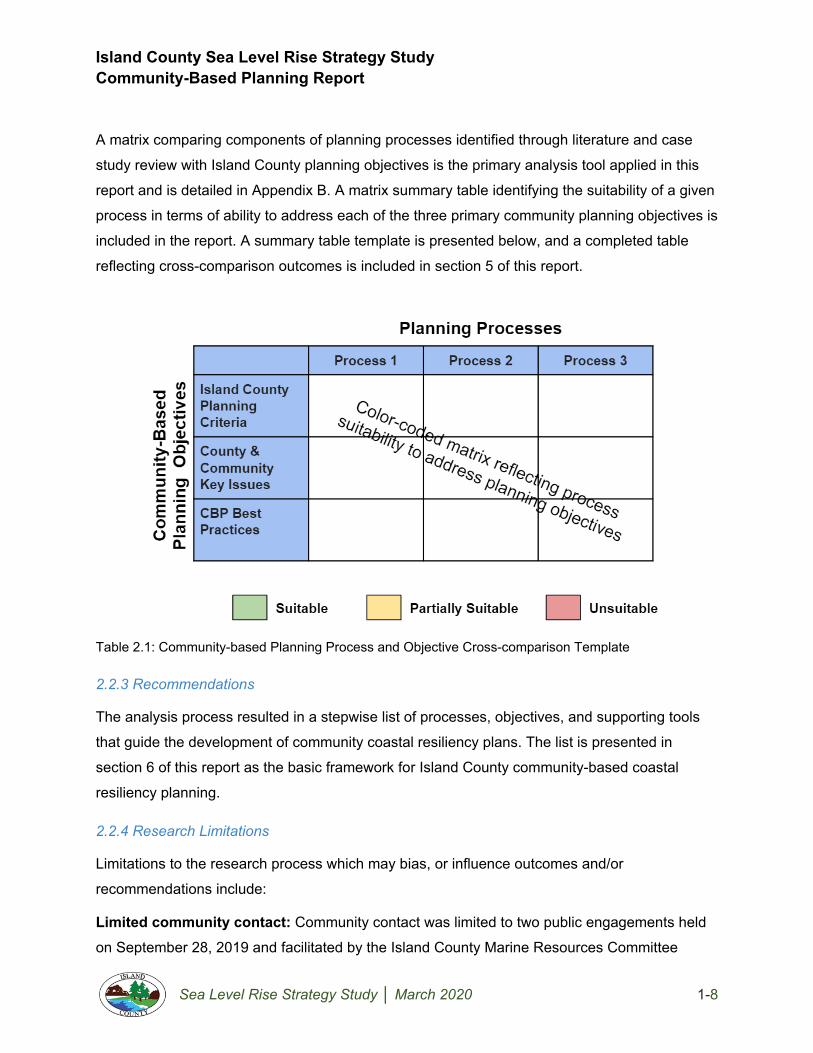
Island County Sea Level Rise Strategy Study Community-Based Planning Report
Sea Level Rise Strategy Study │ March 2020 1-8
A matrix comparing components of planning processes identified through literature and case
study review with Island County planning objectives is the primary analysis tool applied in this
report and is detailed in Appendix B. A matrix summary table identifying the suitability of a given
process in terms of ability to address each of the three primary community planning objectives is
included in the report. A summary table template is presented below, and a completed table
reflecting cross-comparison outcomes is included in section 5 of this report.
Table 2.1: Community-based Planning Process and Objective Cross-comparison Template
2.2.3 Recommendations
The analysis process resulted in a stepwise list of processes, objectives, and supporting tools
that guide the development of community coastal resiliency plans. The list is presented in
section 6 of this report as the basic framework for Island County community-based coastal
resiliency planning.
2.2.4 Research Limitations
Limitations to the research process which may bias, or influence outcomes and/or
recommendations include:
Limited community contact: Community contact was limited to two public engagements held
on September 28, 2019 and facilitated by the Island County Marine Resources Committee
Island County Sea Level Rise Strategy Study Community-Based Planning Report
Sea Level Rise Strategy Study │ March 2020 1-9
(MRC), an advisory group comprised of community volunteers and Island County staff. All other
information related to community issues referenced in this report was obtained through County
staff interviews, which may result in a biased assessment of community objectives.
Anecdotal issue identification: Few County and/or community issues and concerns identified
during data collection were supported by documentation. County staff interviews and observed
community feedback at MRC forums informed these issues and related planning objectives,
which also may result in a biased assessment of community objectives.
Limited precedent availability: Little literature or case study data documenting purely
community-based coastal resiliency planning exists. In most cases, community actions connect
to established government plans, programs and resources. Because that is not the case in
Island County, the local effectiveness of community-based planning best practices identified in
this report may be limited.
Monitoring program uncertainty: Community coastal resilience plan implementation is
partially dependent on a community’s ability to monitor sea level and project sea level rise.
Communities currently have access to citizen science-based shoreline ecosystem monitoring
resources through organizations such as the Island County Marine Resources Committee,
Sound Water Stewards, and the Puget Sound Partnership. In addition, Island County is
developing a monitoring program specific to sea level rise which may influence the planning
framework recommended in this report. Revision of the planning framework proposed in this
report may be necessary to incorporate the monitoring program upon establishment.
3. Existing Conditions Existing conditions are detailed in Volume 1 of this report. Key takeaways particularly relevant to
the development of a community-based coastal resilience planning framework include:
3.1 Shoreline Community Characterization
At over 196 miles in length, the Island County shoreline is the longest contiguous shoreline in
Washington State. The coast is characterized by low lying beaches and spits, dredged canals,
wetlands, high unstable bluffs, and residential development. Approximately 63% of the Island
County shoreline is designated for residential land use; and approximately 28% of shoreline
properties lie within designated Historic Beach and Canal communities, and areas that contain

Island County Sea Level Rise Strategy Study Community-Based Planning Report
Sea Level Rise Strategy Study │ March 2020 1-10
steep and/or unstable slopes referred to in this report as Feeder Bluff communities (Island
County, 2012). These communities are the focus of this report, and variations in environmental
designations, community development patterns, and regulations were specifically considered in
developing the community-based planning framework.
3.2 Community Character
Island County coastal communities are primarily comprised of homeowners at or above the
median income and age without many mobility restrictions; many of whom maintain shoreline
properties as second or vacation homes (NOAA, 2019).
3.3 Coastal Flooding Issues
Community member and County concerns based on review of historical coastal flooding events,
associated flood damage repair permits, and interview responses from County representatives
who regularly engage with community members indicate significant interest in protecting private
property from inundation and flood damage; particularly related to structural foundations, water,
and wastewater systems (Island County, 2019).
3.4 Current Plans, Policies, and Regulations
Current plans, policies, and regulations base coastal flood risk assessments and development
regulations primarily on U.S. Federal Emergency Management Agency (FEMA) National Flood
Insurance Program (NFIP) Flood Insurance Rate Maps (FIRMs), which establish base flood
elevations reflecting a 100-year, or 1% annual chance flood event. These projections do not
account for extreme high tides or projected sea level rise. Potential impacts of projected sea
level rise are addressed in some detail in the Island County Shoreline Master Program (SMP)
and Hazard Mitigation Plan (HMP). The County shoreline development permitting process
effective at the time of this report, however, limits consideration of these projected impacts to
required marine and steep slope buffers, shoreline setbacks, and minimum structure bottom
floor elevation equivalent to the FEMA base flood elevation for new development (Island
County, 2016; 2019).
4. Literature Review This section provides a review of the literature addressing community-based planning history,
foundational elements, best practices, and established processes and tools related to coastal

Island County Sea Level Rise Strategy Study Community-Based Planning Report
Sea Level Rise Strategy Study │ March 2020 1-11
resilience planning. Outcomes of this review informed selection of community-based planning
framework components best suited to support Island County shoreline community planning
objectives.
4.1 Background
Though a universal definition of community-based planning has not been established among
academics and planning professionals, the definition presented by the Southern Rural
Development Center as a “local voluntary planning process that is designed to build, strengthen
and support community structure” which involves “individual and associational actors from
various social fields coming together to develop and implement an interlinking, comprehensive
and coordinated plan of action” perhaps best describes the dynamic process as it applies to
Island County coastal resilience planning (Theodori, 2007).
Since the 1980s, community-based planning has gained significant momentum as a method of
addressing site and topic-specific planning issues through community engagement. Historically,
topics and issues typically addressed through community-based planning include community
development, economic revitalization, public safety, and natural resource conservation (ILJ,
2002; Garzón et al., 2012). More recently, community-based planning has emerged as a widely
leveraged approach to climate change and sea level rise adaptation in the absence of
institutional plans and regulations (Garzón et al., 2012; USAID, 2013; NOAA, 2019).
Community-based planning processes exist in many forms; however, a primary objective of
developing solutions to local issues representative of community values and priorities is
generally consistent across applications (ILJ, 2002; Freitag et al., 2015; Moyo et al., 2016;
Etingoff, 2017). This review examines literature and case studies related to community-based
planning to identify foundational principles, key elements of successful implementation, and
examples of processes related to climate change and sea level rise adaptation. Ultimately,
literature review outcomes will be referenced to develop a coastal resilience and sea level rise
adaptation community-based planning framework for Island County shoreline communities.
4.2 Community-Based Planning: Foundational Processes
Community-based planning models are plentiful and have led to varying degrees of plan
implementation success depending on communities served, process objectives, and
circumstances driving the need for community involvement. Most models follow a similar

Island County Sea Level Rise Strategy Study Community-Based Planning Report
Sea Level Rise Strategy Study │ March 2020 1-12
general structure, which begins with identification of planning issues and stakeholders, followed
by collaborative community development of approaches to address these issues,
implementation of a selected approach, and outcome assessment to inform future community
decisions related to the issues (ILJ, 2002; Theodori, 2007; Etingoff, 2017). Community-based
planning processes are applied in many forms and across many fields to address community-
specific issues ranging from public health and safety concerns to community development
initiatives. A model developed by the U.S. Department of Justice, known as the Scanning,
Analysis, Response, and Assessment (SARA) Problem Solving Model, perhaps best describes
the foundational process behind CBP processes and tools (ILJ, 2002).
Figure 4.1: Scanning, Analysis, Response, and Assessment (SARA) Model
Source: Office of Community Oriented Policing Services, US Department of Justice
Though the SARA model was designed for and is most commonly applied to community-
oriented policing, its principles are generally applicable to many issues a community may face
and warrant consideration in the development of issue-focused community-based planning
processes. In the case of shoreline planning the SARA model provides a basic framework that
community members may reference when addressing issues such as projected sea level rise.
Communities may begin by analyzing risks associated with projected sea level rise; develop and
implement local action plans to address those risks and assess the results of action taken to
inform whether further iterations of the process are necessary to achieve desired outcomes.

Island County Sea Level Rise Strategy Study Community-Based Planning Report
Sea Level Rise Strategy Study │ March 2020 1-13
4.3 Community-Based Planning: Best Practices
Published literature indicates successful implementation of community-based planning
processes and beneficial planning outcomes are related to a multitude of contributing factors;
many of which vary by location and specific issues addressed. Despite this variability, there are
a number of factors consistently identified as key to success across the spectrum of community-
based planning applications, which are presented here as best practices. These practices
include establishment of community awareness regarding planning issues (ILJ, 2002; Etingoff,
2017); community identification of assets and values potentially affected by a given planning
issue (ILJ, 2002; Walter, 2012; Freitag et al., 2015); robust and equitable community member
participation in the planning process (Kent, 1981; ILJ, 2002; Walter, 2012; Etingoff, 2017);
effective planning process facilitation (APA, 1998; Svendsen and Campbell, 2008;
Wongbusarakum et al., 2015); adequate resourcing of the process itself and implementation of
resulting plans (APA, 1998; Theodori, 2007; City of New York, 2019; Svendsen and Campbell,
2008; Moyo and Madlopha, 2016); and meaningful process evaluation to assess effectiveness
and inform future community decisions (ILJ, 2002; Theodori, 2007 Garzón et al., 2012; USAID,
2013; Moyo and Madlopha, 2016; Etingoff, 2017). These best practices are further detailed
below.
4.3.1 Community awareness of planning issues
Awareness of issues affecting communities that may be addressed through community-based
planning occurs in many ways, including through community member experience and third-party
outreach and education. In some cases, communities are driven to act based on their
experience with a particular issue. In others, community outreach and education conducted by
local governments, non-governmental organizations, and/or advocacy groups serve to inform
communities about issues that do or may affect them (ILJ, 2002; Etingoff, 2017). In both cases,
awareness builds interest and investment in taking action at the community level to address the
issue. This interest and investment are fundamental to the success of a community-based
planning approach.
4.3.2 Community identification of critical assets and values
Community members best understand local values and priorities, as well as the assets
associated with them (Freitag et al., 2015). Community-based asset identification is commonly
included in hazard mitigation planning processes and is fundamental to the community-based

Island County Sea Level Rise Strategy Study Community-Based Planning Report
Sea Level Rise Strategy Study │ March 2020 1-14
planning process. Though personal values and priorities may differ among community
members, collective identification of assets which promote overarching community values
provides an indication of what issues are likely to generate widespread public interest and result
in meaningful planning activities (ILJ, 2002; Walter, 2012; Freitag et al., 2015).
4.3.3 Community member participation in the planning process
Without adequate and equitable community representation, community-based planning
processes are unlikely to truly address overarching concerns related to a given issue, and
investment in the implementation of solutions generated through the process may prove
challenging. Robust participation in community-based planning promotes the accurate definition
of community values and critical assets and indicates an increased likelihood of community
member interest and investment in the implementation of resulting plans. Though the definition
of adequate participation may differ between communities based on size and composition,
equitable representation of populations served within a given community forms a baseline
standard (Kent, 1981; ILJ, 2002; Walter, 2012; Etingoff, 2017). Participation in CBP processes
is often rooted in a community-member interest in preserving community character and
influencing public policy which may directly impact their community (Hatley, 2013). In addition to
these driving forces for participation, incentives for involvement in CBP processes that support
both community and local government goals may be leveraged. Examples of incentives related
to land development include free or low-cost expert consultation, permitting fee reduction,
and/or project development and implementation process assistance.
4.3.4 Effective community-based planning process structure
While community-based planning processes are intended to be inclusive and collaborative in
nature, a need for structure and facilitation exists to ensure productive outcomes. Establishment
of the planning process and organizational structure including early identification of community
member roles and responsibilities, planning for administrative and logistics requirements, and
development of a process schedule promote productive engagements, sustained community
interest, and meaningful outcomes (APA, 1998; Svendsen and Campbell, 2008;
Wongbusarakum et al., 2015). Community-based planning processes should be facilitated to
optimize effectiveness, either internally by community members or externally by third-party
government, non-government organization, or advocacy group representatives. In cases
involving complex planning issues, third-party facilitation may prove necessary to maintain and

Island County Sea Level Rise Strategy Study Community-Based Planning Report
Sea Level Rise Strategy Study │ March 2020 1-15
navigate the planning process, organize community input, resolve disputes, and produce
actionable plans.
4.3.5 Adequate resourcing
Community-based planning processes may prove resource-intensive in terms of funding and
human capital required for the process from start to finish; particularly during plan
implementation (Svendsen and Campbell, 2008; Moyo and Madlopha, 2016). At the outset,
communities should identify the time commitment expected of CBP organization members and
contributors, as well as resources that may be needed for plan development. Plans which
identify projects or other actions requiring external funding should include identification of
potential funding sources. Plans addressing complex or technical issues should include input
from and involvement of subject matter experts, which often requires communities to conduct
external outreach to access the necessary expertise (APA, 1998; Theodori, 2007; City of New
York, 2019). Without clear funding strategies and access to the expertise necessary to facilitate
plan implementation, community-based planning processes risk being rendered ineffective.
4.3.6 Effective post-process evaluation
Post-implementation monitoring of plan outcomes is widely regarded as a critical step in
community-based planning processes (ILJ, 2002; Theodori, 2007 Garzón et al., 2012; USAID,
2013; Etingoff, 2017). Community buy-in and confidence in the effectiveness of community
planning processes are key to their success. Monitoring of implementation outcomes provides a
basis for process evaluation necessary to build this confidence and inform future community
plans and decisions (Moyo and Madlopha, 2016, Etingoff, 2017).
4.4 Community-based planning for sea level rise
As climate change and sea level rise adaptation emerge as central community concerns in the
U.S. and abroad, the need for effective community-based planning processes and tools
designed to improve community preparedness and resilience is increasingly evident. A review of
existing literature related to community-based planning introduced a series of best practices that
warrant consideration in developing community-based approaches to coastal resilience
planning. These include:
● Community awareness of planning issues
● Community identification of critical assets and values

Island County Sea Level Rise Strategy Study Community-Based Planning Report
Sea Level Rise Strategy Study │ March 2020 1-16
● Community participation in the planning process
● Effective community-based planning structure
● Adequate implementation resourcing
● Effective process evaluation
Further, community approaches to coastal resilience planning should leverage existing, proven
planning processes and tools to the extent practical. This report details the development of one
such planning approach for Island County shoreline communities in section 5 and presents the
resulting community-based planning framework in section 6.
5. Community-based planning process analysis and outcomes This section details the data analysis component of the research process and presents a
summary of the analysis outcomes. For this project, the analysis process included identification
of existing community-based planning processes and tools which may be adapted to support
Island County community planning objectives; and assessment of the suitability of selected
planning processes and tools to achieve those objectives. Community-based planning
framework objectives introduced in section 2 of this report include:
● Objective 1: Incorporate fundamental coastal resilience planning components
● Objective 2: Address County and community concerns related to coastal flooding and
projected sea level rise
● Objective 3: Maintain consistency with community-based planning best practices
Sections below detail planning processes and tools analyzed for potential use in the community-
based planning framework, and outcomes of process, tool, and planning objective cross-
comparisons.
5.1 Existing Processes and Tools
Community-based planning framework development considered existing planning
processes and tools applied in support of coastal resilience planning in coastal communities
across the U.S. and island nations in the western Pacific Ocean. These resources include the
Federal Emergency Management Agency (FEMA) National Flood Insurance Program (NFIP)
Community Rating System (CRS) Floodplain Management Planning Process, which
encourages local governments to extend flood resilience considerations and development

Island County Sea Level Rise Strategy Study Community-Based Planning Report
Sea Level Rise Strategy Study │ March 2020 1-17
standards beyond basic regulatory requirements and provides planning guidance applicable at
the community level (FEMA, 2017); the National Oceanic and Atmospheric Administration’s
(NOAA) web-based U.S. Climate Resilience Toolkit, which serves as a repository for information
and guidance intended to support communities in planning for projected climate change impacts
(NOAA, 2019); and the Local Early Action Planning (LEAP) community-led coastal resilience
process gaining international attention based on its application in Micronesia (Wongbusarakum
et al., 2015). These tools are not currently leveraged in Island County planning processes and
provide valuable information and examples of effective community engagement strategies which
should be considered when developing community-based coastal resilience plans. An overview
of each process highlighting key components is provided below.
5.2.1 FEMA CRS Floodplain Management Planning
The 2017 Community Rating System Coordinator’s Manual is a guidance document developed
by FEMA to assist local governments in taking floodplain management actions above and
beyond the minimum requirements of the National Flood Insurance Program (NFIP) to protect
community assets and potentially reduce property owner insurance rates. The manual consists
of seven sections that provide a CRS program overview, guidance and regulations governing
program administration, and planning guidelines for local governments (FEMA, 2017). Much of
the manual is intended for local government use to aid in generating land use and development
regulations necessary to establish and maintain CRS eligibility and reduce flood insurance
costs; however, the CRS floodplain management planning process may be scaled and adapted
to support whole community resilience and adaptive capacity development. This report focuses
on the flood damage reduction and planning activities section of the CRS manual, which
includes a four-phase, 10-step floodplain management planning process. The below figure and
process description highlight key elements relevant to community-based planning.

Island County Sea Level Rise Strategy Study Community-Based Planning Report
Sea Level Rise Strategy Study │ March 2020 1-18
Figure 5.2: CRS Floodplain Management
Planning Process Diagram
Phase 1: Planning Process
This phase initiates CRS planning and consists of three distinct steps: organization, public
involvement, and coordination. In the organization step, communities seeking involvement in the
CRS develop a team to include a designated facilitation team and subject matter experts as
needed to navigate aspects of the plan requiring specialized experience. The public involvement
step focuses on gathering citizen input regarding plans and establishing citizen advisory
committees to contribute to the planning process. During the coordination step, communities
review existing plans, flood protection activities, mapping products, etc. for inclusion in local
floodplain management plans.
Phase 2: Risk Assessment
Phase 2 includes assessment of known floodplain-specific hazards, and identification of
potential problems associated with those hazards. In assessing hazards, the community
identifies sources, frequency, extent, and causes of local flooding based on existing plans and
historical flooding data. The community then identifies whether and which natural and/or built
assets that support community values and floodplain functions may be affected by flooding
under anticipated hazard conditions.

Island County Sea Level Rise Strategy Study Community-Based Planning Report
Sea Level Rise Strategy Study │ March 2020 1-19
Phase 3: Mitigation Strategy
Mitigation strategy development is organized into three steps: setting goals, reviewing possible
activities, and drafting an action plan. In setting goals, community planning groups identify
objectives consistent with those of existing formal hazard mitigation plans which address all
known flood-related hazards faced by the community. A review of possible activities entails the
evaluation of a wide range of alternative mitigation strategies extending beyond traditional
solutions. Pros, cons, and implementation considerations related to each potential strategy are
documented in this phase to inform mitigation strategy selection. Mitigation strategies are
selected in this phase based on available resources and anticipated resulting reduction to
community flood risk. Selected mitigation strategies are then aligned with an implementation
schedule to develop a draft floodplain management action plan.
Phase 4: Plan Maintenance
In this phase, the community formally adopts the floodplain management plan through a
documented approval process, initiates plan implementation, evaluates implementation
outcomes, and revises and amends the plan as necessary to reflect changing hazard-related
information and/or adjustments necessary to achieve community objectives. CRS program
certification requires annual plan evaluations and updates at 5-year intervals to ensure plans
remain dynamic and reflect current conditions in the floodplain and local built environment.
Applicability to Island County Community-Based Planning Process
Though the CRS program and associated planning guidance are designed for local government
applications, the 10-step floodplain management planning process is applicable to community
planning initiatives, directly addresses all three Island County community planning objectives,
and is consistent with best practices in community-based planning. Resources supporting each
step including maps and planning templates are publicly available and user-friendly. Further, the
use of CRS planning guidelines to inform community adaptation decisions aligns proposed
actions in established floodplains with existing regulatory standards exceeding those currently
required by Island County, which may position property owners to be eligible for flood insurance
rate reductions as a result of plan implementation.

Island County Sea Level Rise Strategy Study Community-Based Planning Report
Sea Level Rise Strategy Study │ March 2020 1-20
5.2.3 U.S. Climate Resilience Toolkit
The NOAA U.S. Climate Resilience Toolkit is a widely referenced resource for climate change
adaptation planning at the local community scale. The toolkit serves as a repository for climate
change adaptation-related tools and information and includes a basic workflow for building
community resilience to hazards associated with climate change, presented below.
Figure 5.3: Steps to Resilience
Source: US Climate Resilience Toolkit, 2019
The U.S. Climate Resilience Toolkit includes case studies from throughout the U.S. in which
application of this process yielded community-driven climate change adaptation strategies
(NOAA, 2019). Though adaptation strategies developed through this process are generally
community-generated, implementation is largely dependent on local, state, or federal
government funding and technical assistance in many cases. It should be noted that multiple
professional planning organizations have developed community assistance programs intended
to provide expertise to communities facing challenging planning issues. Examples of these
organizations and programs include the American Planning Association Community Assistance
Program comprised of regional Community Planning Assistance Teams (CPAT) which provide
pro bono community planning support (APA, 2019); and the Community Assistance for Wildfire
(CPAW) initiative established by Headwaters Economics and Wildfire Planning International,
and funded by the U.S. Forest Service and private foundations (CPAW, 2019). A brief summary
of each step from the Toolkit is provided below (NOAA, 2019).

Island County Sea Level Rise Strategy Study Community-Based Planning Report
Sea Level Rise Strategy Study │ March 2020 1-21
Step 1: Explore Hazards
This step includes organizing community members interested and invested in preserving local
assets and values; evaluating past and projected weather and climate trends and identifying
critical assets that may be affected by climate change. This step is characterized by community
asset and value identification and leveraging the best available science and third-party expertise
to educate community members on the range of likely future climate scenarios. The outcome of
this step is a determination of whether climate change projections present a hazard to critical
community assets and/or values.
Step 2: Assess Vulnerability & Risks
Vulnerability and risk assessments include the identification of potential climate change-related
impacts on community assets and values. This step is intended to encourage communities to
engage in risk management by evaluating the probability and severity of potential hazards in
terms of impact on community well-being. The outcome of this step is a risk determination in
which the community decides whether projected climate risks to assets and value are
acceptable or require mitigation.
Step 3: Investigate Options
This step includes identification of alternative mitigation strategies for climate risks to community
assets and/or values which were deemed unacceptable. The investigation includes a review of
case studies in which similar risks were responded to by other communities to identify a range
of potential actions, and evaluation of the feasibility of local implementation of potential actions.
The outcome of this step is a list of feasible alternatives the community may consider for further
action.
Step 4: Prioritize & Plan
Prioritization includes evaluation and ranking of costs, benefits, and community capacity to
complete alternative actions developed in the previous step. During this step, the community
integrates the highest-ranking actions for which capacity exists and develops a stepwise plan to
complete them. The plan should identify stakeholder roles and responsibilities; and account for
timeline, resource, administrative, and logistical actions necessary for objective attainment. The

Island County Sea Level Rise Strategy Study Community-Based Planning Report
Sea Level Rise Strategy Study │ March 2020 1-22
outcome of this step is a comprehensive implementation plan for the community’s favored
actions.
Step 5: Take Action
This step involves the implementation of the community-generated plan by stakeholders who
accept responsibility and coordinate the resources necessary to accomplish plan objectives. In
addition to implementing the plan, this step includes periodic monitoring, reviewing, and
reporting on outcomes to identify whether actions effectively increase community resilience and
address climate risk to assets and values. This step is ongoing through the completion of an
action or project and results in lessons learned which may be used to inform future community
planning processes.
Applicability to Island County Community-Based Planning Process
The U.S. Climate Resilience Toolkit Steps to Resilience directly address all three Island County
community planning objectives and includes user-friendly planning templates designed for use
by community members. Additionally, the toolkit includes links to case studies and an extensive
repository of tools and resources which may be leveraged by community-based planning
facilitators to optimize process effectiveness with limited need for outside expertise. Further, the
toolkit serves as a convenient source of location-specific information for use in community
outreach and education related to coastal resilience; and provides an opportunity for community
feedback and contribution to document local planning actions and process effectiveness.
5.2.3 Local Early Action Planning (LEAP) Process
In 2010 a collaborative group of community organizations and conservation advocacy groups
developed a process for coastal community vulnerability assessment and climate change
adaptation planning known as the Local Early Action Planning (LEAP) process. The four-step
process is outlined below, and a template intended to guide communities through the
development of an action plan is available through the US Coral Triangle Initiative Support
Program (USAID, 2013).

Island County Sea Level Rise Strategy Study Community-Based Planning Report
Sea Level Rise Strategy Study │ March 2020 1-23
Figure 5.4: Climate Change Adaptation Local Early Action Planning (LEAP) Process
Source: USAID LEAP Guide, 2013
Among communities engaging in the LEAP process, reported benefits include ease of
application, the potential for use as a standalone tool, and multidisciplinary stakeholder
involvement. Limitations include the time-consuming nature of such a highly participatory
process, difficulty scaling to communities with urban development or complex governance
structures, limited guidance on plan implementation, and a typical requirement for outside entity
technical support to truly understand and adequately address critical vulnerabilities. A brief
summary of the LEAP process phases is provided below.
Step 1: Getting Organized for Climate Change Adaptation Planning
In preparation for climate change adaptation planning, communities must identify stakeholders
representing local interests and technical expertise necessary to address specific issues that
may arise. In this step of the LEAP process, communities must identify process facilitators and
ensure adequate information, authority, and resources are available to complete the process
(USAID, 2013). The outcome of this step is an established community planning organization
with clear roles and responsibilities; and a community background narrative that provides
context and describes the community’s need for climate change adaptation.
Step 2: Telling Your Climate Story
This step of the LEAP process includes communicating scientific and local knowledge related to
potential climate change impacts to the extended community to inform risk decisions. Through
telling the climate story, community members are made aware or reminded of potential changes
to their physical, ecological, and social environment, and may demonstrate increased interest

Island County Sea Level Rise Strategy Study Community-Based Planning Report
Sea Level Rise Strategy Study │ March 2020 1-24
and/or investment in adaptation planning. The outcome of this step is a climate story which uses
a combination of visualizations, computer-based scenario modeling, and documented local
impacts collected through public participation to present past, present, and projected future
hazards related to climate change with the potential to affect assets and values identified as key
to community well-being.
Step 3: Conducting a Vulnerability Assessment
The vulnerability of a community asset or value is identified by its exposure, sensitivity, and
adaptive capacity to climate threats. In this step, vulnerabilities of social, economic, ecological,
and infrastructure assets are evaluated together, given their dependency on one another in
coastal areas. A vulnerability assessment is initially completed through qualitative evaluation of
how likely it is that community values and associated assets will be affected by climate change.
The assessment may be expanded to include quantitative analysis where potential impacts can
be quantified and evaluated for significant relationships and/or trends. The outcome of this step
is a vulnerability assessment that helps explain community vulnerability to climate change
impacts and inform risk-based decisions regarding adaptation alternatives.
Step 4: Developing a Local Early Action Plan
The Local Early Action Plan identifies effective and feasible actions communities may take to
increase resilience and reduce climate change risks. The LEAP process includes the
identification and prioritization of adaptation options based on effectiveness, feasibility, and
cost/benefit analysis outcomes. The plan includes an implementation schedule and identifies
partners and external resources necessary to complete priority adaptation actions. The plan
extends beyond implementation to include benchmarking and monitoring strategies to evaluate
plan performance and inform future community planning decisions. The final LEAP includes all
products generated in the four-step process. Templates and worksheets for each step of the
process are included in the appendices of the 2013 USAID LEAP Guide and may be edited to
reflect application in areas other than the Coral Triangle, for which the process was initially
developed.

Island County Sea Level Rise Strategy Study Community-Based Planning Report
Sea Level Rise Strategy Study │ March 2020 1-25
Applicability to Island County Community-Based Planning Process
The LEAP process is consistent with best practices in community-based planning and
addresses multiple aspects of Island County coastal resilience planning criteria and County and
community issues and concerns. The LEAP Guide provides step by step instructions as well as
user-friendly worksheets and templates for community-led development of coastal adaptation
plans. These worksheets are intended for small island communities and do not necessarily
reflect all planning considerations required of complex community organizations; however,
LEAP tools and resources may be adapted to reflect Island County-specific planning issues.
The LEAP process ends with the development of an action plan and does not directly address
the implementation or monitoring of plan outcomes. Despite this limitation, the use of LEAP
process guidelines and adapted worksheets in combination with plan implementation and
evaluation processes included in other tools referenced in this report may provide a viable and
complete planning model for Island County communities.
5.3 Community-based planning process suitability analysis
Cross-comparison of Island County community-based planning objectives and elements of the
FEMA CRS Floodplain Management Planning, U.S. Climate Resilience Toolkit, and LEAP
processes identifies the suitability of each of the tools for consideration in the Island County
community-based planning framework. The below diagram highlights key components of the
cross-comparison process and outcomes.
Figure 5.1: Community-based Planning Framework Development Process

Island County Sea Level Rise Strategy Study Community-Based Planning Report
Sea Level Rise Strategy Study │ March 2020 1-26
The capacity of a given process and its associated tools to address Island County community
planning objectives and their sub-components determined suitability for consideration in the
community-based planning framework. Section 2 of this report details Island County planning
objectives, and a summary is provided below.
Table 5.1: Community-Based Planning Objectives and Sub-Components
Cross comparison of the three planning processes with Island County planning objectives is
detailed in Appendix B. The appendix includes a matrix that identifies planning process
components that directly address a given community planning objective sub-component as
suitable for consideration in community-based planning framework development (color-coded
green). Similarly, the analysis identifies process components that address a given planning
objective sub-component but do not provide supporting tools and resources as partially suitable
(color-coded yellow); and process components that do not address a given objective sub-
component as unsuitable (color-coded red).
Suitability of each process in terms of ability to address the three primary Island County
planning objectives was determined as a function of combined sub-category ratings. Processes
rated as suitable (green) represent 75% or more suitable (green) sub-component ratings for a
given planning objective and no unsuitable (red) ratings. Processes rated as partially suitable

Island County Sea Level Rise Strategy Study Community-Based Planning Report
Sea Level Rise Strategy Study │ March 2020 1-27
(yellow) represent less than 75% suitable (green) sub-component ratings for a given planning
objective and less than 50% unsuitable (red) ratings, as well as those with one or more
unsuitable (red) rating. Processes rated as unsuitable (red) represent 50% or more unsuitable
(red) sub-component ratings for a given planning objective. The below summary table presents
process suitability ratings at the Island County planning objective level.
Table 5.2: Community-Based Planning Process and Objective Suitability Matrix
As evidenced by cross-comparison outcomes, each of the processes analyzed contains tools
applicable to community-based planning objectives, with FEMA CRS floodplain management
guidance and the U.S. Climate Resilience Toolkit demonstrating the capacity to address all
objectives. Analysis trends included a limited reference in all three processes to tools supportive
of post-implementation plan monitoring and reference to general planning and implementation
funding sources such as federal grant programs rather than process-specific funding
opportunities. LEAP process shortfalls affecting suitability included the absence of
implementation and post-implementation guidance, and limited examples or potential adaptation
strategies applicable to Island County community issues and concerns. The strengths of each
process include clarity of process guidance, which generally aligns with Island County planning
requirements and community-based planning best practices. Specific strengths of the U.S.
Climate Resilience Toolkit and LEAP process include the provision of clear and useful planning
templates intended for community use in developing location-specific resilience plans. The

Island County Sea Level Rise Strategy Study Community-Based Planning Report
Sea Level Rise Strategy Study │ March 2020 1-28
community-based coastal resilience planning framework references elements of each process
detailed above, selected based on their alignment with Island County planning objectives.
6. Island County CBP Framework The Island County community-based coastal resilience planning framework establishes a
stepwise planning process intended to achieve community planning objectives and guide
communities in the development of coastal resilience plans. The framework incorporates
adapted elements of the FEMA CRS floodplain management planning, U.S. Climate Resilience
Toolkit, and LEAP processes identified as supportive of Island County community planning
objectives and connects users to additional resources associated with each planning step.
Island County Community-Based Coastal Resilience Planning Framework Step 1: Define planning issues and establish a community planning team
Step 2: Identify community values and vulnerable assets
Step 3: Analyze risk and establish thresholds for action
Step 4: Develop and implement resilience strategies and projects
Step 5: Monitor outcomes to inform future plans
Step 1a: Define Planning Issues
Objective: This initial step in the community-based planning process is
intended to raise community awareness of potential future issues related to
projected sea level rise. In many cases in Island County, shoreline property
owners have experienced impacts of extreme high tides and have a sense of
what sea level rise may mean for them; however, concerted outreach efforts to
ensure common public knowledge and access to information are critical to the planning process.
Processes and Tools: Processes and tools which may assist with this step include a review of
Washington State sea level rise projections and use of the NOAA Sea-Level Rise Viewer web
tool to run user-friendly scenarios reflecting various sea level rise conditions.

Island County Sea Level Rise Strategy Study Community-Based Planning Report
Sea Level Rise Strategy Study │ March 2020 1-29
Figure 6.1: NOAA SLR Viewer and WA State SLR Projections
Sources: NOAA; Miller et al., 2018
Supporting Resources: These processes and tools may be leveraged by individuals, but are
likely more effective when explored in group settings. Public outreach by advisory groups such
as the Island County Marine Resources Committee (MRC), supported by representatives from
the Department of Natural Resources, Planning, and Environmental Health has proven an
effective mechanism for engagement. Island County provision of an online and physical
resource repository with these and other informational tools may bolster the success of these
engagements by providing community members easy access to the best available science and
technical expertise related to projected sea level rise. Further, communities with established
formal and informal representative organizations and/or associations may leverage them, as
well as online community notification platforms such as “Nextdoor.”
Step 1b: Establish a Community-based Planning Team
Objective: This step is intended to identify stakeholders representing
community demographic profile and interests to act as the primary planning
body responsible for coordinating administrative and logistics requirements
of the process. This group may vary in size but must provide a holistic
representation of the community to optimize effectiveness and identify local expertise which
may be helpful in addressing the particular issue.
Processes and Tools: Processes and tools which may assist with this step include those
outlined in CRS Floodplain Management Planning Phase 1 (organize & involve the public), U.S.

Island County Sea Level Rise Strategy Study Community-Based Planning Report
Sea Level Rise Strategy Study │ March 2020 1-30
Climate Resilience Toolkit step 1 (explore hazards) and the LEAP worksheet 3 (stakeholder
identification). Applicable planning guidance and templates are included for reference in
Appendix C and provide step by step processes to identify groups and interests which should be
included in a community-based planning team.
Supporting Resources: As with the previous step, these processes and tools prove most
effective when explored in group settings and are facilitated through established formal and
informal representative organizations and/or associations, or through input solicitation through
online community platforms.
Step 2: Identify Community Values and Vulnerable Assets
Objective: This step is intended to identify community goals, values, and their
supporting assets. Goals should be big picture and reflect community
aspirations, values should include aspects of the community which members
desire to maintain or preserve, and assets should reflect the capital (physical
or otherwise) which supports both the values and goals. Though County
identification of infrastructure necessary to support accessibility, health, and life-safety in a
given community, it is important that this step is completed by community members to document
what is important enough to warrant expenditure of time and effort in the planning process.
Processes and Tools: Processes and tools which may assist with this step include those
outlined in CRS Floodplain Management Planning Phase 2 (assess the hazard & problem), U.S.
Climate Resilience Toolkit step 1 (explore hazards) and the LEAP worksheets 4 and 7
(community profile & target mapping); each of which provide step by step processes to identify
what is important to community stakeholders and mapping those values to assets within the
community. These worksheets are included in Appendix C.
Supporting Resources: The Island County Hazard Mitigation Plan identifies critical community
assets and vulnerabilities but is mostly focused on major public infrastructure systems. Though
the scope of HMP critical asset assessment may not align with local community concerns, the
document provides a good example of how a community might document this step. In addition,
the U.S. Climate Resilience Toolkit includes a link to case studies related to each phase of
resilience planning. A review of case studies may prove useful in initiating this step.

Island County Sea Level Rise Strategy Study Community-Based Planning Report
Sea Level Rise Strategy Study │ March 2020 1-31
Step 3a: Analyze Risk
Objective: This step is intended to assess risk introduced by potential sea
level rise to community assets identified in the previous step. The process
should account for environmental stressors (flooding, septic system overflow,
groundwater contamination, etc.) and non-environmental stressors (evacuation
planning, valuable preservation, family concerns, etc.) associated with sea
level rise and reflect an overall risk assessment based on probability of occurrence and
magnitude of impact if a major flooding event takes place. Probability is relatively objective
given sea level rise projections and community experience to date with extreme high tide
flooding; however, the magnitude may be more subjective based on a given community’s values
associated with at-risk assets.
Processes and Tools: Processes and tools which may assist with this step include those
outlined in CRS Floodplain Management Planning Phase 2 (risk assessment), U.S. Climate
Resilience Toolkit step 2 (assess risks), and LEAP worksheet 8 (threat mapping); each of which
provide step by step processes to identify hazard probability and magnitude and develop an
overall risk definition. The U.S. Climate Resilience Toolkit Risk Characterization Matrix is
pictured below. Other referenced processes and tools are detailed in Appendix C.

Island County Sea Level Rise Strategy Study Community-Based Planning Report
Sea Level Rise Strategy Study │ March 2020 1-32
Figure 6.2: Risk Characterization Matrix
Source: U.S. Climate Resilience Toolkit
Supporting Resources: The Island County Hazard Mitigation Plan catalogs risk to critical
assets but is mostly focused on those pertaining to public infrastructure and general community
groups (vulnerable communities, etc.). Though the scope of HMP critical asset and vulnerable
population assessments may not align with local community concerns, the document provides a
good example of how a community might document this step. In addition, the U.S. Climate
Resilience Toolkit includes a link to case studies related to each phase of resilience planning. A
review of case studies may prove useful in initiating this step and as a basis of comparison for
outcomes.
Step 3b: Establish Thresholds for Action
Objective: This step is intended to identify acceptable risk at the community
asset level and establish thresholds for community action in the event risk
becomes unacceptable. This step is heavily dependent on community goals
and values and is likely to be specific to each community. For example, the
image below shows Camano Island’s Livingston Bay under 2050 projected
sea level rise and extreme high tide conditions. Under these circumstances, communities may
determine that action well in advance of 2050 is necessary to preserve their property.
Figure 6.3:
Livingston Bay Potential
Inundation (2050)
Source: Miller et al., 2016

Island County Sea Level Rise Strategy Study Community-Based Planning Report
Sea Level Rise Strategy Study │ March 2020 1-33
Processes and Tools: Processes and tools which may assist with this step include those
outlined in CRS Floodplain Management Planning Phase 2 (risk assessment), U.S. Climate
Resilience Toolkit step 2 (assess risks), and LEAP worksheet 8 (threat mapping). These
references and tools provide guidance related to decision points at which community planning
groups will need to determine whether to take action to preserve assets and either protect,
redefine, or reassign values. Referenced processes and tools are detailed in Appendix C.
Supporting Resources: At the time of this report, the Island County Planning Department is in
the process of developing a sea level rise monitoring plan intended to leverage existing tide
gauges and other monitoring and relay devices to effectively monitor changing sea levels and
inform communities of SLR trends. Once available, this tool may be a valuable resource used
by communities to inform future risk decisions. In addition to future sea level rise monitoring, the
Island County Hazard Mitigation Plan recommends the development of a comprehensive threat
monitoring program and identifies some key elements of what the monitoring plan should
include. Communities may use HMP recommendations to inform the development of local
monitoring plans. Ultimately, communities must decide the level of risk their communities are
willing to accept and take action accordingly.
Step 4a: Develop Solutions
Objective: This step is intended to identify potential sea level rise adaptation
strategies and project alternatives capable of mitigating risk to community
assets and values while complying with applicable guidelines and regulations.
In this step community planning groups will develop a list of local sea level rise
adaptation strategies and projects, and assess their effects on community
asset resilience, economic viability, local and regional environmental impact,
and implementation feasibility, among other factors. This process is intended to
result in a prioritized list of viable short, medium, and long-term projects representing applicable
protection, accommodation, and managed retreat adaptation strategies for which the community
may pursue funding and implementation support.
Processes and Tools: Processes and tools which may assist with this step include those
outlined in CRS Floodplain Management Planning Phase 3 (mitigation strategy), U.S. Climate
Resilience Toolkit steps 3 & 4 (investigate options, prioritize & plan), and LEAP worksheet 9

Island County Sea Level Rise Strategy Study Community-Based Planning Report
Sea Level Rise Strategy Study │ March 2020 1-34
(identify early actions). Each tool provides guidance related to identifying key comparable
aspects of potential projects, assessing project feasibility given accessible community
resources, and prioritizing projects in terms of urgency and implementation feasibility. A sample
project feasibility matrix from the U.S. Climate Resilience Toolkit is presented below, and other
referenced tools are detailed in Appendix C.
Figure 6.4: Adaptation Project Feasibility Matrix
Source: U.S. Climate Resilience Toolkit
Supporting Resources: Adaptation strategy examples are available through many sources to
include the U.S. Climate Resilience Toolkit case studies, Sea Grant coastal property owner
guides, and the Washington Department of Fish and Wildlife publication Your Marine
Waterfront: A guide to protecting your property while promoting healthy shorelines (WDFW,
2016). In addition, organizations and programs such as the Shore Friendly program supported
and administered by the Washington Department of Natural Resources, Washington
Department of Fish and Wildlife, and the U.S. Environmental Protection Agency, provide
planning guidance and resources to support community decisions to pursue nature-based
coastal adaptation projects (Shore Friendly, 2019). Most relevant to Island County, however, are
shoreline sea level rise adaptation best management practices developed through this project;
which represent short, medium, and long-term protection, accommodation, and retreat
strategies gleaned from case studies in similar communities throughout the U.S. and abroad.

Island County Sea Level Rise Strategy Study Community-Based Planning Report
Sea Level Rise Strategy Study │ March 2020 1-35
Step 4b: Implement Solutions
Objective: This step is intended to provide guidance on the
implementation of selected community planning actions, to include sea
level rise adaptation strategies. Plan implementation relies heavily on
funding and enduring community support; therefore it is imperative that
strategy or project leads are assigned, a clear project implementation
process and timeline are established, and sources of project funding are identified in this step.
Processes and Tools: Processes and tools which may assist with this step include those
outlined in CRS Floodplain Management Planning Phase 3 (plan maintenance), U.S. Climate
Resilience Toolkit step 5 (take action), LEAP worksheet 19 (work plan), and Island County
shoreline development regulations. The first three tools provide general implementation plan
development guidance and are detailed in Appendix C. County development regulations specify
permitting requirements, timelines, and costs related to shoreline projects, and are available on
the Island County website.
Supporting Resources: Federal, state, and local project implementation and funding support
may be available for selected adaptation projects in the form of conservation and emergency
preparedness grants, conservation district financial assistance, property tax reductions through
the Washington State Public Benefit Rating System for natural shoreline restoration, and free or
low-cost technical assistance (FEMA, 2019; Washington DNR, 2019). The U.S. Coastal
Resilience Toolkit and Shore Friendly program provide listings of nationwide and Island County-
specific funding opportunities available today. In the future, Island County may pursue additional
incentives for coastal resilience projects.
Step 5: Monitor Outcomes
Objective: This step is intended to provide guidance on community monitoring
of adaptation strategy and project outcomes, documentation of project
effectiveness, and generation of lessons learned to inform future iterations of
the project and/or related planning decisions. Monitoring and feedback allow
communities to optimize the effectiveness of the community-based planning
process. This step requires community planning group dedication and
continuity to ensure lessons learned are effectively passed on and applied to future initiatives.

Island County Sea Level Rise Strategy Study Community-Based Planning Report
Sea Level Rise Strategy Study │ March 2020 1-36
Processes and Tools: Processes and tools which may assist with this step include those
outlined in CRS Floodplain Management Planning Phase 3 (plan maintenance) and U.S.
Climate Resilience Toolkit step 5 (Take action). Relatively little related to project monitoring and
feedback is included in the LEAP process; however, community-based planning literature
consistently identifies this step as critical to project and/or process effectiveness. Referenced
processes and tools are detailed in Appendix C.
Supporting Resources: Examples of project monitoring are provided in U.S. Climate
Resilience Toolkit case studies; and the U.S. Department of Homeland Security Coastal
Hazards Center of Excellence Disaster Recovery Tracking Tool is an example of a tool which
may be adapted to the Island County CBP process (NOAA, 2019).
7. Conclusions This report provides a recommended Island County community-based coastal resilience
planning framework and documents supporting research and development. The proposed
framework addresses specific planning issues related to extreme flooding events and projected
sea level rise faced by Island County shoreline communities; reflects best practices in
community-based planning processes and tools specific to coastal flooding and projected sea
level rise, and leverages those processes and tools to support coastal resiliency planning.
The research documented in this report indicates methods for communities to engage in
planning and implementation of adaptation strategies intended to reduce risk to individual
property owner and community assets associated with projected sea level rise. As identified in
this report, keys to community-based planning framework success include extensive and
equitable community member involvement; access to the expertise necessary to educate
community members of planning issues and inform planning decisions; adequate resourcing of
implementation plans; and post-implementation monitoring of project outcomes to track
performance and inform future planning decisions and projects.
7.1 Next Steps
A community guide to coastal resiliency planning is included as Appendix C to this report. The
guide details community actions necessary to complete each step of the planning framework
outlined in this report and provides worksheets and additional resources adapted from existing
planning processes and tools to facilitate community planning. Completion of these planning

Island County Sea Level Rise Strategy Study Community-Based Planning Report
Sea Level Rise Strategy Study │ March 2020 1-37
steps and associated worksheets will provide communities with the fundamental components of
a coastal resilience plan and assist them in developing and implementing short, medium, and
long-term sea level rise adaptation strategies.
7.2 Further Research
Additional research is necessary to provide a comprehensive guide to community coastal
resilience planning and is recommended to address the limitations of research documented in
this report. This section highlights identified research shortfalls and/or areas that may warrant
further research to better position Island County communities to plan for coastal resilience.
7.2.1 Community-based planning incentive opportunities
Identification and evaluation of coastal resilience planning incentives employed in other U.S.
communities will inform recommendations for Island County’s consideration. Effective incentives
for planning participation are key to forming a community-based planning team, and the addition
of thoroughly researched incentive recommendations would strengthen the proposed planning
framework. Potential incentives to explore include permit fee reductions, streamlined permitting
processes, and free technical assistance with planning and design for projects supportive of
coastal resilience in communities with established coastal resilience plans.
7.2.2 Sea-level rise monitoring and threshold establishment
Upon establishment of an Island County sea level rise monitoring plan and completion of a
scheduled 2020 Island County Shoreline Master Program update, which will include sea level
rise considerations, further research into how both can best be incorporated into the proposed
community-based planning framework will be necessary.
7.2.3 Adaptation planning for vulnerable populations
The shoreline community in Island County is generally characterized as older, relatively affluent,
and generally mobile. Further research into the location and extent of vulnerable shoreline
populations and how community-based planning guidance may be effectively leveraged by them
is necessary to make this project’s deliverable a universally applicable product.

Island County Sea Level Rise Strategy Study Community-Based Planning Report
Sea Level Rise Strategy Study │ March 2020 1-38
References American Planning Association. “Community Planning Assistance Teams.” Accessed November
15, 2019. https://www.planning.org/communityassistance/teams/.
Campbell, Lindsay K. and Erika Svendsen. 2008. "Urban Ecological Stewardship: Understanding the Structure, Function and Network of Community-based Urban Land Management." Cities and the Environment 1, no. 1: 4-31. https://doaj.org/article/93d01ee4f8224c848be867a5be6e711f.
City of New York, NY. (Department of City Planning). 2019. “Community-Based Planning.” Accessed November 15, 2019. https://www1.nyc.gov/site/planning/community/community-based-planning.page.
Etingoff, Kim. 2017. Urban Land Use: Community-Based Planning. 2017. Waretown, NJ: Apple Academic Press.
Freitag, Robert C., Daniel B Abramson, Manish Chalana, and Maximilian Dixon. 2014. “Whole Community Resilience: An Asset-Based Approach to Enhancing Adaptive Capacity Before a Disruption.” Journal of the American Planning Association 80, no. 4: 324-335. https://doi.org/10.1080/01944363.2014.990480.
Garzón, Catalina, Heather Cooley, Matthew Heberger, Eli Moore, Lucy Allen, Eyal Matalon, Anna Doty, and the Oakland Climate Action Coalition. (Pacific Institute). 2012. “Community Based Climate Adaptation Planning: Case Study of Oakland, California.” California Energy Commission. Publication number: CEC-500-2012-038.
Glaser, Barney G., and Strauss, Anselm L. 1967. The Discovery of Grounded Theory: Strategies for Qualitative Research. Chicago: Aldine Publishing.
Gombos, Meghan, Scott Atkinson, and, Supin Wongbusarakum. 2013. “Adapting To A Changing Climate: Guide To Local Early Action Planning (LEAP) And Management Planning.” Micronesia Conservation Trust: Pohnpei, Federated States of Micronesia.
Hatley, Pamela Jo. 2013. “Preserving Place: A Grounded Theory of Citizen Participation in Community-Based Planning.” PhD diss., University of South Florida.
Headwaters Economics and Wildfire Planning International. 2019. “Community Planning Assistance for Wildfire (CPAW). Accessed November 15, 2019. https://planningforwildfire.org/.
Institute for Law and Justice (ILJ). (Pickett Institute). 2002. “Community-Based Planning.” http://www.ilj.org/publications/docs/Community_Based_Planning.pdf.

Island County Sea Level Rise Strategy Study Community-Based Planning Report
Sea Level Rise Strategy Study │ March 2020 1-39
Island County, Washington. (Department of Emergency Management). 2015. lsland County Multi-Jurisdictional Hazard Mitigation Plan. https://www.islandcountywa.gov/DEM/Pages/Hazard-Mitigation-Plan.aspx.
Island County, Washington. (Department of Planning and Community Development). 2012. Shoreline Master Program. https://www.islandcountywa.gov/Planning/pages/shorelines.aspx.
Island County, Washington. (Department of Planning and Community Development). “SMP Guidance for Island County Homeowners: Shoreline Residential.” https://www.islandcountywa.gov/Planning/Documents/Shorelines/Homeowner_SED-ShorelineResidential.pdf.
Kent, George. 1981. “Community-based planning: A better approach to development?” National Development 22, no. 5: 74-86. http://www2.hawaii.edu/~kent/CommBasedPlng.pdf.
Miller, Ian M., Harriet Morgan, Guillaume Mauger, Tyler Newton, Ray Weldon, David Schmidt, Mark Welch, and Eric Grossman. 2018. Projected Sea Level Rise for Washington State - A 2018 Assessment. A collaboration of Washington Sea Grant, University of Washington Climate Impacts Group, University of Oregon, University of Washington, and US Geological Survey. Prepared for the Washington Coastal Resilience Project. http://www.wacoastalnetwork.com/files/theme/wcrp/SLR-Report-Miller-et-al-2018.pdf.
Miller, Ian M., Sascha Petersen, Matt Fougerat, Dawn Pucci, Lori Clark and Brian Wood. 2016. “Sea Level Rise and Coastal Flood Risk Assessment for Island County.” Presentation, Island County Department of Natural Resources, Island County, WA, September 27, 2016. https://www.islandcountywa.gov/Health/DNR/PublishingImages/Pages/Iverson-Improvement-Project/Miller_IversonMeeting_27Sept16.pdf.
Moyo, T, Madlopha, S.S. 2016. “An evaluation of the role of community-based planning in Integrated Development Planning Process in Umjindi Local Municipality, Mpumalanga Province.” University of Limpopo. http://hdl.handle.net/10386/1600.
National Oceanic and Atmospheric Administration (NOAA). 2019. “Coastal County Snapshots: Island County, WA.” Digital Coast. Coastal County Snapshots. Accessed December 5, 2019. https://coast.noaa.gov/snapshots/#/process?action=flood&state=53&county=029&bounds=-123.1700601153469,47.50402862695134,-121.94961198208226,48.81157046930632.
Penny, Meredith. 2019. “Island County Shoreline Master Program Update.” Presentation, Island County Marine Resources Committee, Island County, WA, September 28, 2019. https://www.islandcountymrc.org/media/19027/penny-island-county-shoreline-master-program-update.pdf.

Island County Sea Level Rise Strategy Study Community-Based Planning Report
Sea Level Rise Strategy Study │ March 2020 1-40
Shore Friendly. 2019. “Resources in Your Area: Island County.” Washington Department of Natural Resources, Washington Department of Fish and Wildlife, U.S. Environmental Protection Agency. Accessed December 5, 2019. http://www.shorefriendly.org/resources/resources-in-your-area/island/.
Theodori, Gene. 2007. Preparing for the Future: A Guide to Community-Based Planning. Southern Regional Development Center and Sam Houston State University. http://srdc.msstate.edu/publications/archive/243-1.pdf.
Micronesia Conservation Trust and US Coral Triangle Initiative Support Program. 2012. Guide to Vulnerability Assessment and Local Early Action Planning (VA-LEAP). http://www.pimpac.org/images/file/VA_LEAP_FINAL.pdf.
U.S. Climate Resilience Toolkit. 2019. “Steps to Resilience.” Accessed December 5, 2019. https://toolkit.climate.gov/#steps.
U.S. Federal Emergency Management Agency. 2017. National Flood Insurance Program Community Rating System Coordinator’s Manual. OMB No. 1660-0022. https://www.fema.gov/media-library-data/1493905477815-d794671adeed5beab6a6304d8ba0b207/633300_2017_CRS_Coordinators_Manual_508.pdf
Walter, Cheryl L. and Cheryl A. Hyde. 2012. Walter, Cheryl L. L., and Cheryl A. A. Hyde. "Community Building Practice: An Expanded Conceptual Framework." In Community Organizing and Community Building for Health and Welfare: Third Edition, 78-90. Vol. 9780813553146. Rutgers University Press.
Wongbusarakum, Supin, Meghan Gombos, Britt-Anne A. Parker, Catherine A. Courtney, Scott Atkinson & Willy Kostka. 2015. “The Local Early Action Planning (LEAP) Tool: Enhancing Community-Based Planning for a Changing Climate.” Coastal Management 43, no. 4: 383-393, https://doi.org/10.1080/08920753.2015.1046805.
Washington Department of Fish and Wildlife. Your Marine Waterfront: A guide to protecting your property while promoting healthy shorelines. 2016

Island County Sea Level Rise Strategy Study Community-Based Planning Report
Sea Level Rise Strategy Study │ March 2020 1-41
Appendix 3A: Island County Staff Interview Questions Island County Sea Level Rise Strategy Study Initial Interview Questions Purpose: To familiarize UW student researchers with Island County coastal zone management plans, policies, and processes; and to inform the development of sea level rise adaptation best management practices and a community-based coastal resiliency planning framework. Questions:
1. What is your role working for Island County related to coastal and canal flooding mitigation, preparedness, response, and/or recovery concerns?
2. (2-part question) Do your department plans, policies, and/or processes (existing and in progress) related to coastal development and resource management address potential impacts of extreme flooding events and projected sea level rise? If not, are there specific barriers to consideration of these topics?
3. In your department, what are the primary (top 3-5) concerns related to extreme flooding events and projected sea level rise in Island County Historic Beach, Coastal Bluff, and Canal Communities?
4. Based on your interactions with community members and coastal property owners, what are the primary (top 3-5) community concerns related to extreme flooding and projected sea level rise in Island County Historic Beach, Coastal Bluff, and Canal Communities?
5. Does your department maintain information and/or resources which may be useful for
private property owners and communities in developing coastal resiliency plans (e.g. flood preparedness guidance, coastal development permitting guidelines, etc.)?
6. (2-part question) What residential community and/or private property owner actions do you recommend to address potential impacts of extreme flooding events and projected sea level rise? Are you aware of counties or cities with similar challenges that have adopted sea level rise adaptation strategies which may be applicable to Island County?
7. Are you aware of and/or involved in existing Island County or Washington State programs which provide financial support or incentive for private property owner or community projects which may lessen impacts of bluff erosion, coastal or canal flooding?

Island County Sea Level Rise Strategy Study Community-Based Planning Report
Sea Level Rise Strategy Study │ March 2020
Appendix 3B: CBP Process and Objective Cross-comparison

Island County Sea Level Rise Strategy Study Community-Based Planning Report
Sea Level Rise Strategy Study │ March 2020 1-43

Island County Sea Level Rise Strategy Study Community-Based Planning Report
Sea Level Rise Strategy Study │ March 2020 1-44

Island County Sea Level Rise Strategy Study Community-Based Planning Report
Sea Level Rise Strategy Study │ March 2020
Appendix 3C: Community-Based Planning Guidebook

Island County Sea Level Rise Strategy Study Community-Based Planning Report
Sea Level Rise Strategy Study │ March 2020
Table of Contents Guidebook Overview .................................................................................................................. 1
What is community-based planning? ........................................................................................ 1
Why is coastal resilience planning important? .......................................................................... 1
Who should participate in coastal resilience planning? ............................................................. 1
How does the planning process work? ...................................................................................... 3
Steps to Community-Based Coastal Resilience Planning ...................................................... 4
Step 1: Define Planning Issues and Establish a Planning Team .............................................. 4
Worksheet 1A: Community Profile ......................................................................................... 8
Worksheet 1B: Sea Level Rise (SLR) Projections ................................................................. 9
Worksheet 1C: Identifying and Involving Stakeholder Groups ............................................ 12
Worksheet 1D: Identifying and Involving Individual Stakeholders ....................................... 13
Step 2: Identify Community Values and Vulnerable Assets .................................................... 14
Worksheet 2A: Community Values, Goals, and Assets ....................................................... 16
Worksheet 2B: Community Asset Vulnerability ................................................................... 17
Step 3: Analyze Risk and Establish Thresholds for Action ...................................................... 18
Worksheet 3: Risk Assessment and Community Action Threshold ..................................... 22
Step 4: Develop and Implement Coastal Resilience Strategies and Projects ......................... 26
Worksheet 4A: Develop Solutions ....................................................................................... 29
Worksheet 4B: Implement Solutions .................................................................................... 36
Step 5: Monitor Outcomes ....................................................................................................... 39
Worksheet 5: Monitor Outcomes ......................................................................................... 41
Finalizing the Coastal Resilience Plan .................................................................................... 42
Additional Information and Resources ................................................................................... 43
Island County Sea Level Rise Strategy Study Community-Based Planning Report
Community-Based Coastal Resilience Planning Guidebook │ March 2020 1
Guidebook Overview This guidebook is provided as a resource for Island County community members to assist in
planning and implementing coastal resilience strategies and projects at the local level. The
guidebook provides background information on the concept of community-based planning and
the importance of coastal resilience, followed by a stepwise guide to conducting community-
level planning complete with planning templates and links to additional information and
resources. Through applying the process outlined in this guidebook, Island County residents will
have access to the information and resources necessary to develop community-specific coastal
resilience plans and improve preparedness for the future.
What is community-based planning?
Community-based planning is, generally, a voluntary local planning process which brings
together people and groups from various backgrounds within a community to develop and
implement a coordinated plan of action to address a particular issue or set of issues. For Island
County residents, community-based planning presents the opportunity for community members
to identify and work to resolve issues of concern through local, non-governmental action.
Why is coastal resilience planning important?
As our climate changes, so will many factors which may affect both the shoreline ecosystems
and existing properties. These factors include potential sea level rise and increased frequency
and intensity of extreme weather events. Current projections indicate Island County may
experience between 1-3 feet of sea level rise by 2100 which may, in many cases, result in
issues such as increased frequency and extent of coastal flooding, increased coastal erosion,
impacts to coastal groundwater quality, and habitat loss. Planning for coastal resilience is
something that can take place within communities recognizing the importance to take action to
address these issues with or without government policy or direction.
Who should participate in coastal resilience planning?
All Island County shoreline properties may benefit from coastal resilience planning. Research
supporting this guidance focuses on three community types identified as most likely to be
affected by projected sea level rise. These include designated Historic Beach and Canal
communities, and areas that contain steep and/or unstable slopes referred to in this guidebook

Island County Sea Level Rise Strategy Study Community-Based Planning Report
Community-Based Coastal Resilience Planning Guidebook │ March 2020 2
as Coastal and Feeder Bluff communities. A brief description of each community type based on
the Island County Shoreline Master Program (SMP) is provided below:
Historic Beach Communities
Densely platted small lots with residential structures
constructed thirty feet or less from the ordinary high water
mark; typically established prior to Washington State’s
1972 adoption of the Shoreline Management Act.
Canal Communities
Residential communities developed along engineered
canals. These communities are typified by residential
structures constructed above the ordinary high water
mark with dedicated waterfront access.
Feeder Bluff Communities
Coastal and Feeder Bluff communities consist of
residential development atop and at the base of steep or
unstable slopes that are subject to coastal and surface
water erosion as part of natural ecosystem processes.
Historic Beach Community Example Source: Island County SMP Guidance
Canal Community Example Source: Island County SMP Guidance
Coastal (Feeder) Bluff Community Example Source: WA Coastal Atlas
Historic Beach Community Example Source: Island County SMP Guidance

Island County Sea Level Rise Strategy Study Community-Based Planning Report
Community-Based Coastal Resilience Planning Guidebook │ March 2020 3
How does the planning process work?
The Island County community-based coastal resilience planning framework establishes a
stepwise planning process intended to achieve community planning objectives and ultimately
develop community-specific coastal resilience plans. The framework incorporates adapted
elements of existing planning processes and tools developed by the U.S. Federal Emergency
Management Agency (FEMA), National Oceanic and Atmospheric Administration (NOAA), and
the U.S. Coral Triangle Initiative Support Program; and connects users to additional resources
associated with each planning step.
Island County Community-Based Coastal Resilience Planning Framework
The following section of this guidebook details objectives, community actions, and resources
related to each step in the planning process. Worksheets associated with each step of the
process provide templates that communities may use to document their decisions and actions.
Through completing the process steps and worksheets, communities will develop a baseline
coastal resilience plan which may be used as a basis for implementing sea level rise adaptation
projects. The process is intended to be iterative, and regular review of planning assumptions
and process outcomes is necessary to ensure plans consider current information related to
climate change and adaptation best practices.

Island County Sea Level Rise Strategy Study Community-Based Planning Report
Community-Based Coastal Resilience Planning Guidebook │ March 2020 4
Steps to Community-Based Coastal Resilience Planning
Step 1: Define Planning Issues and Establish a Planning Team
In order to effectively plan, community members must first identify specific issues which need to
be addressed through community action and establish a planning team representative of
community interests comprised of members who are willing and able to commit to the planning
process from beginning to end.
Define Planning Issues
Objective This initial step is intended to raise awareness of potential issues related to
projected sea level rise. In this step, Island County residents concerned
with current or future issues related to coastal flooding identify the extent to
which sea level rise may affect their community,
Process
1. Develop a community profile – Document basic community characteristics (population,
community designation, etc.) as well as current and future general coastal resilience
concerns. Include physical issues such as property damage and habitat loss, and non-
physical issues such as quality of life impacts, and economic impacts. The profile should
also identify existing community generated plans that address coastal issues.
2. Identify local sea level rise projections - The Washington Coastal Hazards Resilience
Network published Projected Sea Level Rise for Washington State: a 2018 Assessment
which provides a range of sea level rise projections for Island County reflecting various
probabilities of exceedance and timelines. Using this resource, communities may identify
the different amounts of sea level rise associated with multiple scenarios. Projections used
for Island County planning purposes are presented below.

Island County Sea Level Rise Strategy Study Community-Based Planning Report
Community-Based Coastal Resilience Planning Guidebook │ March 2020 5
The two tables shown above, prepared using Miller et al., 2018 sea level rise projections,
represent two different greenhouse gas scenarios (RCP 4.5 and RCP 8.5). More information
about how to understand sea level projections can be found on the Coastal Hazards
Resilience Network website listed under tools and supporting resources below.
The column on the left provides three different time frames for planning consideration. This
allows the user to compare projected rises in sea level over different times based upon
planning horizons or lifespan of a project.
The row across the top allows the user to select a probability that sea levels will reach or
exceed a given amount of sea level. For example, the “very likely” column of numbers
relates to the high probability (95%) that sea level will exceed the numbers given. By
contrast, the “unlikely” column provides numbers where it is highly unlikely (1%), although
possible, that sea levels would reach that number.

Island County Sea Level Rise Strategy Study Community-Based Planning Report
Community-Based Coastal Resilience Planning Guidebook │ March 2020 6
3. Model local sea level rise impacts - User-friendly online mapping and modeling tools such as
the National Oceanic and Atmospheric Administration (NOAA) Sea Level Rise Viewer
enable Island County residents to view potential impacts of sea level rise in their
communities. Community members should model multiple scenarios representing various
sea level rise projections to gain a basic understanding of the likelihood of sea level rise
affecting them according to current projections.
NOAA Sea Level Rise Viewer Interactive Mapping Tool
4. Decide to plan - Based on the outcome of sea level rise projection modeling, communities
will identify what is potentially at risk and decide whether coastal resilience planning is in
their best interest. In reaching this decision, communities may want to consult with citizen
scientists and advocacy groups working on climate change and sea level rise initiatives,
such as the Island County Marine Resources Committee, to review model results and gain
insight on related concerns.
Tools and supporting resources
● Washington Coastal Hazards Resilience Network http://www.wacoastalnetwork.com
● Projected Sea Level Rise for Washington State: A 2018 Assessment http://www.wacoastalnetwork.com/wcrp-documents.html
● NOAA Sea-Level Rise Viewer https://coast.noaa.gov/slr/
● Island County Marine Resources Committee website https://www.islandcountymrc.org/

Island County Sea Level Rise Strategy Study Community-Based Planning Report
Community-Based Coastal Resilience Planning Guidebook │ March 2020 7
Planning template Use worksheet 1A to build a community profile. Use worksheet 1B to document sea level rise
projections, model outputs, and additional information supporting the community’s decision to
plan.

Island County Sea Level Rise Strategy Study Community-Based Planning Report
Community-Based Coastal Resilience Planning Guidebook │ March 2020 8
Worksheet 1A: Community Profile
Instructions and Example: Describe community characteristics and identify primary concerns and current local plans related to coastal flooding and projected sea level rise. Community Name & Location: Enter common name of community and general physical location Community Type: Select Historic Beach Community, Canal Community, Coastal Bluff Community, or Other Community Population (estimate): Coastal Resilience Concerns (Existing Conditions): Identify top (1-3) coastal resilience issues your community currently faces. Issues may be physical (property damage, habitat loss, etc.) or non-physical (quality of life impacts, economic impacts, etc.).
Coastal Resilience Concerns (Future Projections): Identify top (1-3) coastal resilience issues your community is concerned may emerge as a result of projected sea level rise. Issues may be physical or non-physical. Existing Plans: List existing local community generated plans which address coastal flooding issues or development guidelines. Examples include community Covenants, Conditions & Restrictions (CC&Rs), community design guidelines, neighborhood emergency management plans, community environmental conservation plans, water system plans, etc. Do not include local government plans. An example is provided below:
Existing Plan
Title
Plan Created
By
Plan Date
Plan Location (web link or
physical location and contact
number)
Coastal Resilience
Considerations
Neighborhood
CC&Rs
Neighborhood Homeowners Association
January 2020
HOA Website:
www.website.com
Shoreline development restrictions
Private beach maintenance requirements
Worksheet adapted from US Coral Triangle Initiative Local Early Action Planning Tool

Island County Sea Level Rise Strategy Study Community-Based Planning Report
Community-Based Coastal Resilience Planning Guidebook │ March 2020 9
Worksheet 1B: Sea Level Rise (SLR) Projections
Instructions and Example: Document sea level rise model parameters and outcomes for each scenario in the table below. Communities are encouraged to model numerous scenarios spanning the range of sea level rise projections. An example entry is provided for reference.
Global
Emissions Scenario
(RCP 4.5 or RCP 8.5)
SLR
Projection Timeline
SLR Projection Probability of Exceedance (Very Likely,
Likely, Unlikely, Mid-
Range)
Projected
SLR* (feet)
NOAA SLR
Viewer Community
Impacts
Community
Planning Recommendation
RCP 8.5
2100
Mid-Range (17-83%)
1.5-3.0
Yes – Partial
Inundation at 2-3 ft.
Conduct coastal
resilience planning
*SLR projection source: Miller et al., 2018, Projected Sea Level Rise for Washington State - A 2018 Assessment. Prepared for the Washington Coastal Hazard Resilience Network. Prepared for the Washington Coastal Resilience Project. http://www.wacoastalnetwork.com/files/theme/wcrp/SLR-Report-Miller-et-al-2018.pdf.

Island County Sea Level Rise Strategy Study Community-Based Planning Report
Community-Based Coastal Resilience Planning Guidebook │ March 2020 10
Establish a Community Planning Team
Objective This step is intended to identify community representatives to act as the
primary planning group responsible for coordinating administrative and
logistics requirements of the coastal resilience planning process. This
group may vary in size but must provide a holistic representation of the
community to optimize effectiveness
Process 1. Identify potential stakeholders (groups) - Identify professional, social, and other groups or
organizations which may have an interest in community planning efforts. This stakeholder
group must be representative of the demographic and economic spectrum within the
community and may include outside individuals or groups with technical expertise relevant
to the planning issue(s).
2. Identify stakeholder representatives (individuals) - For each stakeholder group, identify a
specific candidate to represent the group’s interest in the planning process. Include contact
information and, when possible, preferred contact days/times.
3. Conduct outreach - Contact stakeholder representatives to discuss planning issues and
request involvement in the planning process. Obtain agreement to participate and document
constraints on availability.
4. Establish Team Roles - Identify volunteers for key positions within the planning team to
include administrative, logistics, and communication leads. Team members assigned to
these positions should be willing and able to commit to involvement for the duration of the
planning process and are instrumental in ensuring timely and effective completion. Specific
responsibilities of each position may vary based on planning team size and complexity of
planning issues addressed.

Island County Sea Level Rise Strategy Study Community-Based Planning Report
Community-Based Coastal Resilience Planning Guidebook │ March 2020 11
Tools and supporting resources Stakeholder identification is most effective when conducted in a group setting. Community
members are encouraged to solicit input from formal and informal representative organizations
such as the Marine Resources Committee, homeowner’s and/or neighborhood associations,
and online community platforms such as Nextdoor.
● Island County Marine Resources Committee website https://www.islandcountymrc.org/
● Nextdoor website https://nextdoor.com/find-neighborhood/wa/
Planning template Use worksheets 1C and 1D to document stakeholder identification, outreach, and role
establishment.

Island County Sea Level Rise Strategy Study Community-Based Planning Report
Community-Based Coastal Resilience Planning Guidebook │ March 2020 12
Worksheet 1C: Identifying and Involving Stakeholder Groups
Instructions and Example: Identify formal and informal groups of people with potential interest in the planning issue and/or process outcomes. Document their interest and importance to the process in the table below. An example entry is provided for reference
What are the main groups of people involved in the
community?
Describe their interest How important is this group to the planning
process?
How and when should they be involved in the
planning process?
Property owners Property ownership and community resource access
Very important From the beginning of the process. Involve them in issue identification, all regular planning meetings, progress updates, and regular feedback opportunities.
Community associations
Non-governmental organizations
Community service organizations
County Departments
State Agencies
Federal Agencies
Other
Worksheet adapted from US Climate Resilience Toolkit “Documenting Steps to Resilience”

Island County Sea Level Rise Strategy Study Community-Based Planning Report
Community-Based Coastal Resilience Planning Guidebook │ March 2020 13
Worksheet 1D: Identifying and Involving Individual Stakeholders
Instructions and Example: Identify individual representatives for stakeholder groups that should be involved in the planning process Use the below table to document coordination with potential stakeholder group representatives and their involvement in the planning process. An example is provided for reference
Stakeholder Group
Individual Stakeholder
Contact Information
(preferred phone and email)
Planning Team Role
Comments
Property owners John Doe Cell: 555-5555
Email: [email protected]
Administrative Coordinator
Available M/W evenings 5pm-7pm
Has legal experience
Worksheet Adapted from US Climate Resilience Toolkit “Documenting Steps to Resilience”

Island County Sea Level Rise Strategy Study Community-Based Planning Report
Community-Based Coastal Resilience Planning Guidebook │ March 2020 14
Step 2: Identify Community Values and Vulnerable Assets
Objective This step is intended to identify community values, goals, and their supporting
assets. Values should include aspects of the community which members
desire to maintain or preserve, goals should be big picture and reflect
community aspirations, , and assets should reflect the capital (physical or
otherwise) which supports community values and goals.
Process 1) Identify community values and goals - Stakeholders collectively identify values that
contribute to community character, culture, and identity; as well as aspirational goals that
reflect and help to achieve the identified values for the future of the community. It is
imperative that members of all stakeholder groups are involved in this step to ensure values
and goals represent diverse community perspectives.
2) Identify supporting assets - Stakeholders identify tangible and intangible assets within the
community which support or enable community values and goals. Assets should extend
beyond critical infrastructure necessary to maintain basic community services, and include
elements such as individual and community property, shared community knowledge,
culturally significant sites and activities, and natural resources.
3) Identify asset vulnerabilities – Stakeholders document climate and non-climate stressors
affecting key community assets and identify the “tipping point” at which an asset will lose its
functionality or negatively impact community values and goals. This step includes a
vulnerability assessment for each asset in which community members determine whether
effects of projected sea level rise for each scenario modeled in step 1 might negatively
impact a given asset to the point where it is no longer able to perform its primary function in
support of community values and goals. Vulnerability ratings take into account the likelihood
sea level rise may affect the asset based on NOAA Sea Level Rise Viewer model output,
and the asset’s adaptive capacity, or ability to be modified to maintain its primary function
despite projected sea level rise impacts. A matrix identifying vulnerability ratings based on
likelihood of sea level rise impact and adaptive capacity is provided below as an aid to
completing this step. As shown in the matrix, low likelihood of sea level rise impact
combined with high adaptive capacity results in low asset vulnerability; whereas high

Island County Sea Level Rise Strategy Study Community-Based Planning Report
Community-Based Coastal Resilience Planning Guidebook │ March 2020 15
likelihood of sea level rise impact and low adaptive capacity result in high asset vulnerability.
Asset Vulnerability Matrix
Like
lihoo
d of
SLR
Impa
ct >
Very High Very High High
Very High High Moderate
High Moderate Low
Adaptive Capacity >
Tools and supporting resources Online tools such as the U.S. Climate Resilience Toolkit Steps to Resilience, and the University
of Kansas Community Toolbox provide examples of community asset identification which may
assist in beginning a community-specific asset identification process.
● U.S. Climate Resilience Toolkit - Steps to Resilience (Step 1: Explore Hazards) https://toolkit.climate.gov/steps-to-resilience/explore-hazards
● University of Kansas - Community Toolbox https://ctb.ku.edu/en/table-of-contents/assessment/assessing-community-needs-and-resources/identify-community-assets/main
Planning template Use worksheet 2A to document community values, goals, and assets. Use worksheet 2B to
document asset vulnerability.

Island County Sea Level Rise Strategy Study Community-Based Planning Report
Community-Based Coastal Resilience Planning Guidebook │ March 2020 16
Worksheet 2A: Community Values, Goals, and Assets
Instructions and Example: Document values which define community character, goals related to the values, and assets (physical and non-physical) supporting both the values and goals which may be impacted by projected sea level rise. Include asset condition and comments as applicable. Example provided for reference. An example is provided for reference
Community Value
Community Goal Asset & Type (Built
Environment, Natural
Resource, Social, etc.)
Asset Condition (poor, fair,
good, excellent)
Comments
Connection to natural environment
Improve community access to beach and wetland
Coastal trail network
Good Trail network exists, but requires clearing and maintenance
Worksheet adapted from US Coral Triangle Initiative Local Early Action Planning Tool and NOAA coastal adaptation guidance

Island County Sea Level Rise Strategy Study Community-Based Planning Guidebook
Community-Based Coastal Resilience Planning Guidebook │ March 2020 17
Worksheet 2B: Community Asset Vulnerability
Instructions and Example: Document issues which may affect community assets as well as climate and non-climate stressors which contribute to their potential impact. An example is provided for reference.
• Identify climate and non-climate stressor trends (improving, worsening, etc.), what the tipping point would be for the asset to be significantly impacted, and the estimated probability that the tipping point scenario will occur.
• Identify the asset adaptive capacity (or ability to be modified to maintain its primary function) over a range of potential impacts.
• Finally, identify the asset vulnerability as a function of probability of tipping point occurrence and adaptive capacity (high probability of occurrence and low adaptive capacity lead to high vulnerability; low probability of occurrence and high adaptive capacity lead to low vulnerability, etc.). Reference the vulnerability matrix included in step 2 process description to assist with rating asset vulnerability.
Community
Asset
Climate Stressor and Trend
Non-Climate Stressor and
Trend
Tipping Point Probability of tipping point
occurring (unlikely, likely,
very likely)
Asset Adaptive Capacity
(low, moderate, high)
Asset Vulnerability
(low, moderate, high, very high)
Coastal trail network
Sea level rise projected increase of 1-3ft by 2100
Erosion from surface water runoff degrades trail
Trail network inaccessible due to inundation and erosion
Likely Moderate – trail function is restored once area is drained
Moderate
Worksheet adapted from US Climate Resilience Toolkit “Documenting Steps to Resilience”

Island County Sea Level Rise Strategy Study Community-Based Planning Guidebook
Community-Based Coastal Resilience Planning Guidebook │ March 2020 18
Step 3: Analyze Risk and Establish Thresholds for Action
Risk management is a fundamental component of coastal resilience planning. This step of the
process includes identification of risk to community assets introduced by projected sea level
rise; and establishment of thresholds for community action based on risk tolerance.
Analyze Risk
Objective This step is intended to assess risk introduced by projected sea level rise to
community assets identified in the previous step. The process should
account for potential environmental stressors (flooding, septic system
overflow, groundwater contamination, etc.) and non-environmental stressors
(evacuation planning, property preservation, family concerns, etc.) associated with sea level rise
and reflect an overall risk assessment based on probability of occurrence and magnitude of
impact if a major flooding event takes place. This process should be conducted for each
community asset.
Process 1) Determine the probability of sea level rise impacts - Using sea level rise projections and
timelines modeled in step 1, estimate the probability of impacts on assets identified in step
2. Categorize probability of exceedance as very likely (95% model), likely (50%), or unlikely
(1%). See step 1 for information on how to read and interpret sea level rise probability
tables.
2) Determine the magnitude of projected sea level rise impacts - Based on the extent of
coastal flooding modeled in step 1 and asset condition and characteristics defined in step 2,
estimate the magnitude of projected impacts in terms of potential functionality loss.
Characterize magnitude of loss as low (asset damaged but functional), moderate (asset
functionality degraded but can be recovered), or high (non-functional total asset loss).
3) Assign relative risk characterization - Based on cross-comparison of probability and
magnitude of projected sea level impacts to community assets, identify the resulting risk
characterization for each asset under various modeled scenarios. A sample risk
characterization matrix is provided below.

Island County Sea Level Rise Strategy Study Community-Based Planning Guidebook
Community-Based Coastal Resilience Planning Guidebook │ March 2020 19
Risk Characterization
Prob
abilit
y of
occ
urre
nce
>
High Very High Very High
Moderate High Very High
Low Moderate High
Severity of Consequences >
Adapted from the U.S. Climate Resilience Toolkit
Tools and supporting resources The U.S. Climate Resilience Toolkit and FEMA Community Rating System Floodplain
Management Planning Guide (Section 512) provide additional guidance on conducting risk
assessments which may prove beneficial to communities undertaking the process.
● U.S. Climate Resilience Toolkit - Steps to Resilience (Step 2) https://toolkit.climate.gov/steps-to-resilience/assess-vulnerability-risks
● FEMA CRS Coordinator’s Manual - Floodplain Management Planning (Section 512) https://www.fema.gov/media-library-data/1493905477815-d794671adeed5beab6a6304d8ba0b207/633300_2017_CRS_Coordinators_Manual_508.pdf

Island County Sea Level Rise Strategy Study Community-Based Planning Guidebook
Community-Based Coastal Resilience Planning Guidebook │ March 2020 20
Establish Thresholds for Action
Objective
This step is intended to identify acceptable risk at the community asset
level, and establish thresholds for community action in the event the
level of risk becomes unacceptable. This step is heavily dependent on
community goals and values, and thresholds will likely be specific to
each community.
Process 1) Evaluate the effects of asset degradation on community values and goals - Given the
characterization of sea level rise risk to assets developed in the previous step, identify the
resulting qualitative impact on community values and goals. Classify outcomes as no effect
(values and goals unaffected), attainment challenge (values and goals temporarily
impacted), or attainment barrier (values and goals unattainable).
2) Determine an acceptable level of risk - Determine an acceptable level of risk for each asset
identified in step 2 based on the potential impact on community values and goals. For
example, a community may value outdoor recreation (value) made possible by a
neighborhood waterfront trail (asset) which has been identified for community-funded
improvements (goal), and is unlikely to be impacted by sea level rise and if impacted would
only result in a moderate loss (moderate risk characterization). In this scenario, the
community may determine that this level of risk is acceptable, as the asset may be repaired
and would continue to support community values and goals. Increased probability or
magnitude of loss may result in an unacceptable level of risk.
3) Establish a threshold for action - Determine a threshold for action relative to the acceptable
level of risk for each asset. Communities may elect to establish thresholds lower than their
absolute risk tolerance as a proactive measure. Conversely, action thresholds may exceed
risk tolerance in cases that require resources beyond those available to the community.
4) Monitor changing risks - Regularly review available County, State, and local citizen science
resources such as the Washington Coastal Hazards Resilience Network and Island County
Island County Sea Level Rise Strategy Study Community-Based Planning Guidebook
Community-Based Coastal Resilience Planning Guidebook │ March 2020 21
Marine Resources Committee for updates to sea level rise projections. Update risk
characterization accordingly and monitor risk levels in relation to action thresholds.
Tools and supporting resources The U.S. Climate Resilience Toolkit and FEMA Community Rating System Floodplain
Management Planning Guide (Section 512) provide additional guidance that may inform
decisions to take community action.
● U.S. Climate Resilience Toolkit - Steps to Resilience (Step 2) https://toolkit.climate.gov/steps-to-resilience/assess-vulnerability-risks
● FEMA CRS Coordinator’s Manual - Floodplain Management Planning (Section 512) https://www.fema.gov/media-library-data/1493905477815-d794671adeed5beab6a6304d8ba0b207/633300_2017_CRS_Coordinators_Manual_508.pdf
The Washington Coastal Hazards Resilience Network and Island County Marine Resources
Committee are excellent resources for current information related to sea level rise and best
practices in coastal resilience planning.
● Washington Coastal Hazards Resilience Network website http://www.wacoastalnetwork.com/
● Island County Marine Resources Committee website https://www.islandcountymrc.org/
Planning template
Use worksheet 3, sections 1 and 2 to document the probability and severity of risks and
potential consequences of sea level rise for community assets.
Use the worksheet 3 sections 2 and 3 to document the overall risk to individual assets and
community risk tolerance.
Use the worksheet 3 summary table to consolidate risks and action thresholds across
community assets.

Island County Sea Level Rise Strategy Study Community-Based Planning Guidebook
Community-Based Coastal Resilience Planning Guidebook │ March 2020 22
Worksheet 3: Risk Assessment and Community Action Threshold
Instructions Complete a risk assessment worksheet and risk characterization matrix for each community asset evaluated.
• Complete sections 1 and 2 of the risk assessment worksheet for each asset and modeled scenario to identify probability of sea level rise impacts (from Worksheet 1B) and severity of potential consequences of projected sea level rise on the ability of the selected asset to perform its primary function.
• Complete sections 3 and 4 of the worksheet to identify overall risk of sea level rise to the asset using a risk characterization matrix, and community risk tolerance specific to the asset being analyzed
• Enter risk analysis outcomes for each asset and scenario evaluated in the risk assessment summary table. An example is provided for reference.

Island County Sea Level Rise Strategy Study Community-Based Planning Guidebook Worksheet 3: Risk Assessment and Community Action Threshold
Community-Based Coastal Resilience Planning Guidebook │ March 2020 23
Asset: SECTION 1: Potential Sea Level Rise Consequences
Circle all applicable across the three categories Economic People & Society Environmental
Movement of goods impaired
Movement of people impaired
Employment centers disrupted
Disproportionate impacts on certain business sectors
Lost income
Increased maintenance or repair costs
Other:
Damage to housing and potential displacement
Loss of recreation opportunities
Residents unable to obtain key services
Disproportionate impacts on certain community members
Loss of cultural or historical resources
Personal injury or loss of life Overall decline in quality of life
Other:
Biodiversity or species loss
Habitat fragmentation and/or loss
Loss of flood protection benefits
Water quality decline
Loss of carbon sequestration function
Other:
SECTION 2: Severity of Consequences Using the descriptions below, identify the OVERALL potential level of impact
Rating Description
MINOR
Financial costs to the municipality or community are possible but would be minimal. No expected loss of life, minimal decline in quality of life and little disruption to livelihoods. Property and ecosystem damage might occur but could be repaired without substantial cost or time.
MODERATE
Some financial costs to the municipality or community are possible and would be moderate. No expected loss of life, but there could be a decline in quality of life and some disruption to livelihoods. Recovery of property and ecosystem damage would take longer and be more costly.
SEVERE
Large financial costs or significant inconveniences would be incurred by the municipality or community. The possibility of loss of life or livelihood exists. Significant, and potentially permanent, property or ecosystem damage might occur.
Worksheet adapted from NOAA Coastal Resilience Planning Guidance

Island County Sea Level Rise Strategy Study Community-Based Planning Guidebook Worksheet 3: Risk Assessment and Community Action Threshold
Community-Based Coastal Resilience Planning Guidebook │ March 2020 24
Asset: SECTION 3: Risk Characterization Matrix
Characterize overall risk based on both probability of sea level rise impacts (from Worksheet 1B) and severity of consequences (from Worksheet 3 Section 2) Identify Circle all applicable across the three categories
Risk Characterization
Prob
abili
ty o
f occ
urre
nce
> (fr
om W
orks
heet
1B)
High Very High Very High
Moderate High Very High
Low Moderate High
Severity of Consequences > (from Worksheet 3 Section 2)
SECTION 4: Risk Tolerance Approach Circle all applicable across the three categories
Considerations for risk tolerance:
• What you know about the asset – its uniqueness, function(s) or service(s) it provides, how it connects to other assets, etc.
• How risk averse the community is based on the values or culture of the community.
• How much you/the community can afford to be wrong – someone is going to be liable for the asset, how much are we willing to have something bad happen?
• The type and severity of potential consequences identified in sections 1 and 2.
Rating Description
RISK TOLERANT
Asset can adapt or will experience minimal impacts. Consequences are expected to be low or acceptable.
MODERATE RISK
Some level of acceptable risk. Impact will have some consequences, but these will be tolerable and/or can be overcome relatively easily.
RISK AVERSE
Very little acceptable risk. Impact will be difficult to overcome and should try to be avoided. Planning and actions might include worst case scenarios.
Worksheet adapted from the U.S. Climate Resilience Toolkit “Documenting Steps to Resilience” and NOAA Coastal Resilience Planning Guidance

Island County Sea Level Rise Strategy Study Community-Based Planning Guidebook Worksheet 3: Risk Assessment and Community Action Threshold
Community-Based Coastal Resilience Planning Guidebook │ March 2020 25
Risk Assessment Summary Table
For each asset and sea level rise scenario evaluated enter the projected sea level rise and probability of exceedance (from Worksheet 1B), the severity of consequences of projected sea level rise impacts (from Worksheet 3, Section 2), the scenario risk characterization (from Worksheet 3, Section 3), and overall risk tolerance (from Worksheet 3, Section 4).
Community Asset
Projected Sea Level Rise
(Worksheet 1B)
Probability of Exceedance
(Worksheet 1B)
Severity of Consequences
(Worksheet 3 Section 2)
Risk Characterization
(Worksheet 3 Section 3)
Risk Tolerance
(Worksheet 3 Section 4)
Coastal trail network
Sea level rise projected increase of 1-3ft by 2100
Likely
Minor
Trail function is restored once area is drained
Moderate Moderate
Community desires to maintain or improve asset
Worksheet adapted from US Climate Resilience Toolkit “Documenting Steps to Resilience” and NOAA Coastal Resilience Planning Guidance

Island County Sea Level Rise Strategy Study Community-Based Planning Guidebook
Community-Based Coastal Resilience Planning Guidebook │ March 2020 26
Step 4: Develop and Implement Coastal Resilience Strategies and Projects
This section provides guidance on identifying potential strategies and projects which may
address community issues related to sea level rise, evaluating their feasibility, and leveraging
available resources for implementation. Throughout this step, communities may seek technical
assistance from local government or professional organizations involved in planning, design,
construction, and/or environmental conservation to most accurately estimate feasibility of
prospective solutions.
Develop Solutions
Objective
This step is intended to identify potential sea level rise adaptation strategies
and project alternatives capable of mitigating unacceptable risk to community
assets and values while complying with applicable guidelines and regulations.
In this step community planning groups will develop a list of local sea level
rise adaptation strategies and projects, and assess their effects on
community asset resilience, economic viability, local and regional
environmental impact, and implementation feasibility, among other factors. This process is
intended to result in a prioritized list of viable short, medium, and long-term projects
representing applicable protection, accommodation, and managed retreat adaptation strategies
for which the community may pursue funding and implementation support.
Process 1) List potential strategies and projects - Reference recommended sea level rise adaptation
management practices identified in resources such as the 2020 Island County Sea Level
Rise Strategy Study to identify strategies and/or projects which may address potential
impacts of sea level rise in shoreline communities.
2) Conduct feasibility analysis - Estimate tangible costs and benefits, environmental impacts,
regulatory requirements, and implementation challenges associated with prospective
projects or strategies. Evaluate projects across these and any other pertinent areas to
determine feasibility. Document feasibility determination in table form (example below) for
visual comparison of selected projects. Review of similar past projects and/or subject matter
expert consultation may be necessary to analyze complex projects.

Island County Sea Level Rise Strategy Study Community-Based Planning Guidebook
Community-Based Coastal Resilience Planning Guidebook │ March 2020 27
Adaptation Project Feasibility Matrix
Adapted from the U.S. Climate Resilience Toolkit
3) Determine strategy urgency - Identify the timeframe in which potential strategies must be
resourced and implemented to maintain an acceptable level of risk to community assets.
Classify strategies as immediate (current year), short-term (1-5 yrs.), or long-term (5+ yrs.).
Tools and supporting resources The U.S. Climate Resilience Toolkit and FEMA Community Rating System Floodplain
Management Planning Guide provide additional guidance related to developing and prioritizing
resilience projects which may inform community efforts.
● Island County Sea Level Rise Strategy Study (2020) – Recommended Adaptation Management Practices
● U.S. Climate Resilience Toolkit - Steps to Resilience (Steps 3&4) https://toolkit.climate.gov/steps-to-resilience/investigate-options
● FEMA CRS Coordinator’s Manual - Floodplain Management Planning (Section 512) https://www.fema.gov/media-library-data/1493905477815-d794671adeed5beab6a6304d8ba0b207/633300_2017_CRS_Coordinators_Manual_508.pdf
The Island County Planning Department, Marine Resources Committee, Washington
Department of Fish and Wildlife, and American Planning Association are among the
organizations which can provide access to resources, expertise, and in some cases planning
assistance for community project development.
Island County Sea Level Rise Strategy Study Community-Based Planning Guidebook
Community-Based Coastal Resilience Planning Guidebook │ March 2020 28
● Island County Department of Planning & Community Development (Planning Shorelines) https://www.islandcountywa.gov/Planning/Pages/shorelines.aspx
● Island County Marine Resources Committee website https://www.islandcountymrc.org/
● Washington Department of Fish and Wildlife - Your Marine Waterfront: A guide to protecting your property while promoting healthy shorelines https://wdfw.wa.gov/publications/01791
● American Planning Association - Community Planning Assistance Teams website https://www.planning.org/communityassistance/teams/
Planning template
Use worksheet 4A sections 1 and 2 to document proposed projects and project feasibility
analyses.
Use worksheet 4A section 3 to summarize viable alternative adaptation strategies.

Island County Sea Level Rise Strategy Study Community-Based Planning Guidebook
Community-Based Coastal Resilience Planning Guidebook │ March 2020 29
Worksheet 4A: Develop Solutions Instructions and Example: Use this worksheet to identify potential adaptation strategies which may address projected sea level rise impacts to vulnerable community assets; compare feasibility of alternatives and select a preferred strategy for each community asset; and develop a prioritized list of strategies for future implementation. Additional detail on how to complete and document this step are provided below for reference: • Select potential adaptation strategies specific to each vulnerable community asset (asset
vulnerability identified in Worksheet 2B). Refer to the 2020 Island County Sea Level Rise Strategy Study “Adaptation Practice Recommendation Table” presented below for a baseline list of strategies applicable to Island County.
Sea Level Rise Adaptation Practice Recommendation Table PROTECT ACCOMMODATE RETREAT
SHORT-TERM STRATEGIES (Now - 2050)
Soft Shorelines (H, B, C) Advanced Septic Systems (H, B, C) On-Site Retreat (H, B)
Beach Nourishment (H, B) Anchored Septic Systems (H, B, C) Off-Site Retreat (Some B, C)
Bulkhead/Seawalls (H, B, C) Community Drainfields (H, B, C)
Breakwater (C) Elevated Structures (H, B, C)
Dikes/Levees (H, C) Floodable Spaces (H, B, C)
Dry Floodproofing (H, B, C) Raised Ground (H, B, C)
Floodwall (H, B, C) Water Supply Diversification (H, B, C)
Revetment (H, B, C) Wet Floodproofing (H, B, C)
Utility Relocation & Consolidation (H, B, C)
PROTECT ACCOMMODATE RETREAT
MID-TERM STRATEGIES (2050 - 2070)
Soft Shorelines (H, B, C) Community Drainfields (H, B, C) Off-Site Retreat (H, B, C)
Beach Nourishment (H, B) Elevated Structures (H, B, C)
Bulkhead/Seawalls (H, B, C) Floodable Spaces (H, B, C)
Dikes/Levees (H) Raised Ground (H, B, C)
Dry Floodproofing (H, B, C) Utility Relocation & Consolidation (H, B, C)
Floodwall (H, B, C) Water Supply Diversification (H, B, C)
Wet Floodproofing (H, B, C)
PROTECT ACCOMMODATE RETREAT
LONG-TERM STRATEGIES (2070 - 2100)
Soft Shorelines (H, B, C) Community Drainfields (H, B) Off-Site Retreat (H, B, C)
Water Supply Diversification (H, B)
Utility Relocation & Consolidation (H, B)
Floodable Spaces (H, B, C)
Parenthesis indicate applicable community type: H - Historic Beach, B - Coastal Bluff, C - Canal

Island County Sea Level Rise Strategy Study Community-Based Planning Guidebook
Community-Based Coastal Resilience Planning Guidebook │ March 2020 30
• Complete an adaptation strategy worksheet (Worksheet 4A, Section 1) for each potential strategy.
• Summarize strategy worksheets in a feasibility matrix (Worksheet 4A, Section 2) to compare strategies for each asset.
• Enter the selected strategy(ies) for each asset into a summary table (Worksheet 4A, Section 3). An example entry is provided for reference.

Island County Sea Level Rise Strategy Study Community-Based Planning Guidebook
Worksheet 4A: Develop Solutions
Community-Based Coastal Resilience Planning Guidebook │ March 2020 31
Section 1. Adaptation Strategy Development
Asset: Strategy:
What are you hoping to gain by this strategy? How would this reduce vulnerability?
Costs Benefits Acceptance Required Resources Environmental Impacts Regulatory Requirements Timing/Urgency What is the estimated monetary cost of the strategy? High Moderate Low Estimated Cost:
Is this strategy effective for a range of future climate projections?
Yes
No; only low scenario
No; only high scenario
Why?
To what degree is the community likely to accept the adaptation option? Poor
Fair
Good
Excellent
Why?
What County STAFF TIME might be required for this option?
Existing
New or Additional
Notes:
What impact will the strategy have on the environment? Natural Resource impacts Cultural Resource impacts Shoreline/Land Use impacts Other
What regulatory requirements apply?
Development permitting Environmental permitting Other:
What is the proposed implementation timeline (start and completion)?
Immediate (current year) Short Term (1-5 years) Long Term (5+ years) Urgency drivers:
Are there additional costs associated with this strategy?
Social Political Other:
Does this strategy achieve multiple benefits/goals?
Societal
Economic
Other:
To what degree is there political support for the adaptation option?
Poor Fair Good Excellent
Why?
What TECHNICAL EXPERTISE might be required for this option?
Existing
New or Additional
Notes:
Will potential impacts require SEPA environmental review? Yes No Unsure Notes:
Will a waiver, variance, or conditional use permit be required? Yes (type) No Unsure Notes:
If implementation is delayed, what cost(s) might be incurred?
Are these additional costs anticipated to be:
High Medium Low Notes:
Are the costs equitably and justifiably distributed?
Yes No Unsure Notes:
What MAINTENANCE is required for this strategy?
Continuous Periodic None Notes:
Is this strategy contingent on other actions being implemented first? If so, what?
Worksheet adapted from NOAA Coastal Resilience Planning Guidance

Island County Sea Level Rise Strategy Study Community-Based Planning Guidebook Worksheet 4A: Develop Solutions
Community-Based Coastal Resilience Planning Guidebook │ March 2020 32
Section 2. Adaptation Strategy Feasibility Matrix
Community Asset
Adaptation Strategy
Costs Benefits Acceptance Required Resources
Environmental Impact
Regulatory Requirements
Average Feasibility
Rating
Additional Notes
Coastal Trail Network
Coastal Trail Network Reroute
Permit and SEPA approval required
Feasibility Ratings (copy and paste in matrix): Feasible Potentially Feasible Not Feasible Worksheet adapted from US Climate Resilience Toolkit “Documenting Steps to Resilience”

Island County Sea Level Rise Strategy Study Community-Based Planning Guidebook Worksheet 4A: Develop Solutions
Community-Based Coastal Resilience Planning Guidebook │ March 2020 33
Section 3. Adaptation Strategy Summary
Priority Community Asset
Adaptation Strategy
Overall Feasibility (Average. feasibility
rating)
Timing/Urgency (immediate,
short-term, long-term)
Key Considerations
(barriers, contingencies,
resource requirements, etc.)
1
Coastal Trail Network
Coastal Trail Network Reroute
Short-term
Permit required

Island County Sea Level Rise Strategy Study Community-Based Planning Guidebook
Community-Based Coastal Resilience Planning Guidebook │ March 2020 34
Implement Solutions
Objective This step provides guidance on implementation of selected community
coastal resilience planning actions, to include development of an
implementation plan, project permitting, and identification of funding
sources.
Process 1) Develop an Implementation Plan - Plans should include the mechanism by which coastal
resilience strategies are to be implemented (regulatory update, study, project, etc.), potential
barriers to implementation, identification of key stakeholders necessary to facilitate the
implementation process, and permits and/or approvals necessary for implementation. The
plan should also include an implementation timeline as a basis for progress evaluation.
2) Identify funding sources - Most strategies will require some form of funding to implement. As
part of the implementation process, communities should confirm funding sources as well as
processes and timelines associated with accessing available funds.
Tools and supporting resources
Federal, state, and local project implementation and funding support may be available for
selected adaptation projects. This may take the form of conservation and emergency
preparedness grants including FEMA pre-disaster grants and Island County Salmon Recovery
Program funding; conservation district financial assistance; property tax reductions through the
Washington State Public Benefit Rating System for natural shoreline restoration; and free or
low-cost technical assistance for soft shore projects through the Island County Department of
Natural Resources and partner organizations such as the Northwest Straits Foundation. The
U.S. Coastal Resilience Toolkit and Shore Friendly program provide listings of nationwide and
Island County-specific funding opportunities available today. In the future, Island County may
pursue additional incentives for coastal resilience projects.
● Island County Shoreline Development Permits https://www.islandcountywa.gov/planning/pages/land_use.aspx
● U.S. Climate Resilience Toolkit (Implementation Resources) https://toolkit.climate.gov/steps-to-resilience/take-action
Island County Sea Level Rise Strategy Study Community-Based Planning Guidebook
Community-Based Coastal Resilience Planning Guidebook │ March 2020 35
● U.S. Climate Resilience Toolkit (Funding Opportunities) https://toolkit.climate.gov/content/funding-opportunities
● FEMA Pre-Disaster Mitigation Grant Program https://www.fema.gov/pre-disaster-mitigation-grant-program
● Island County Shore Friendly Program http://www.shorefriendly.org/resources/resources-in-your-area/island/
● Public Benefit Open Space Rating System https://www.islandcountywa.gov/Planning/Pages/pbrs.aspx
Planning template Use worksheet 4B to document proposed project implementation plans and funding sources.

Island County Sea Level Rise Strategy Study Community-Based Planning Guidebook
Community-Based Coastal Resilience Planning Guidebook │ March 2020 36
Worksheet 4B: Implement Solutions Instructions and Example: Use this worksheet to develop an implementation plan for adaptation strategies which may address projected sea level rise impacts to vulnerable community assets. Include implementation mechanisms, implementation process leads, supporting resources such as partnerships and funding sources. Additional detail on how to complete and document this step are provided below for reference:
• Complete a strategy implementation worksheet for each selected strategy and associated vulnerable community asset (selected strategies identified in Worksheet 4A, asset vulnerability identified in Worksheet 2B).
• Enter implementation factors for each strategy in the below summary table. Strategies should be listed in priority order. An example entry is provided for reference.

Island County Sea Level Rise Strategy Study Community-Based Planning Guidebook Worksheet 4B: Implement Solutions
Community-Based Coastal Resilience Planning Guidebook │ March 2020 37
Section 1. Adaptation Strategy Implementation Plan
Strategy: Mechanism:
Circle the primary instrument for implementation: Regulation Legislation Incentive Planning Process Program Project
The primary instrument is:
New
Modification of Existing
Existing, No Modification Needed
Potential Barriers to Implementation What are possible factors that may hinder implementation?
What are some actions to overcome these barriers?
Stakeholders and Partnerships Who makes the decision whether to implement the strategy?
What partnerships can you leverage for implementing the strategy (either internal or external)
Which stakeholders will be impacted by implementation of the strategy? How can you engage them in implementation?
Funding Do funding sources already exist?
Yes No
Funding sources are:
Internal
External
What is the process to request funding?
Steps What needs to be completed before implementation can begin? Indicate appropriate timing next to activity. (Examples: data collection, further research, change in policy(s), building awareness, conducting training and/or outreach, etc.)
Ideas on measuring success and determining the effectiveness of the strategy over time.
Worksheet adapted from NOAA Coastal Resilience Planning Guidance

Island County Sea Level Rise Strategy Study Community-Based Planning Guidebook Worksheet 4B: Implement Solutions
Community-Based Coastal Resilience Planning Guidebook │ March 2020 38
Section 2. Adaptation Strategy Implementation Plan Summary
Priority Community Asset
Stakeholders Adaptation Strategy
Implementation Mechanism
Implementation Partners
Implementation Funding Source
Implementation Timeline
Key Considerations
(barriers, contingencies,
resource requirements,
etc.)
1
Coastal Trail Network
Community Property Owners
Coastal Trail Network Reroute
New Project
Shore Friendly Program
50% Community funds
50% Conservation Grant
Start < 6mo.
Complete < 1 yr.
Permit and SEPA approval required

Island County Sea Level Rise Strategy Study Community-Based Planning Guidebook
Community-Based Coastal Resilience Planning Guidebook │ March 2020 39
Step 5: Monitor Outcomes
Objective This step is intended to provide guidance on community monitoring of
adaptation strategies and project outcomes, documentation of project
effectiveness, and identification of lessons learned to inform future iterations
of the planning process. Effective monitoring and feedback allow
communities to optimize the community-based planning process. This step
requires community planning group dedication and continuity to ensure
lessons learned are effectively passed on and applied to future initiatives.
Process 1) Establish a project monitoring team - Identify community planning team members
responsible for periodic follow-up to ensure projects are on track and to document
outcomes.
2) Conduct periodic evaluation of adaptation strategy implementation - Document progress of
adaptation strategy implementation based on the schedule and milestones established in
the implementation plan. Identify primary causes for delays if encountered, as well as key
factors contributing to timely completion.
3) Evaluate strategy outcomes - Continue periodic post-implementation monitoring to
determine whether strategy or project objectives are achieved. Use this evaluation to inform
continued and/or future planning efforts.
4) Document lessons learned - Identify things that worked well and challenges encountered
throughout the implementation process and post-implementation period. Ensure lessons
learned are made publicly available to inform future community planning efforts.

Island County Sea Level Rise Strategy Study Community-Based Planning Guidebook
Community-Based Coastal Resilience Planning Guidebook │ March 2020 40
Tools and supporting resources Tools and resources which may assist with this step include CRS Floodplain Management
Planning guidance on plan maintenance and U.S. Climate Resilience Toolkit guidance on post-
implementation monitoring.
● U.S. Climate Resilience Toolkit - Monitoring Guidance https://toolkit.climate.gov/steps-to-resilience/take-action
● FEMA CRS Coordinator’s Manual - Floodplain Management Planning (Section 512) https://www.fema.gov/media-library-data/1493905477815-d794671adeed5beab6a6304d8ba0b207/633300_2017_CRS_Coordinators_Manual_508.pdf
Planning template
Use worksheet 5 to outline a post-implementation monitoring plan and capture lessons learned.

Island County Sea Level Rise Strategy Study Community-Based Planning Guidebook
Community-Based Coastal Resilience Planning Guidebook │ March 2020 41
Worksheet 5: Monitor Outcomes
Instructions and Example: Use this worksheet to document implementation progress and post-implementation outcomes. Capture best practices, challenges, and lessons learned to inform future plans. An example is provided for reference. Adaptation Strategy Implementation Plan Summary
Priority Community Asset
Adaptation Strategy
Implementation Status
(Planned, In Progress, Complete,
Delayed)
Implementation Challenges
Implementation Best Practices
Post-Implementation
Asset Vulnerability (low, moderate,
high)
Lessons Learned Future Planning Recommendations
Date of Update
1
Coastal Trail Network
Coastal Trail Network Reroute
Complete
Permitting delay (1mo.)
Regular (monthly) community updates
Low
Ensure permitting requirements and timelines are confirmed prior to project start
Project complete. No further action.
1/24/20
2
3
4
5

Island County Sea Level Rise Strategy Study Community-Based Planning Guidebook
Community-Based Coastal Resilience Planning Guidebook │ March 2020 42
Finalizing the Coastal Resilience Plan With the initial coastal resilience planning process complete, community planning teams have a
basis from which to move forward with prioritized implementation of coastal adaptation
strategies. The final plan should be a consolidated document which includes the completed
contents of worksheets 1-5 and a plan cover sheet which includes the following information:
Island County, WA Community Coastal Resilience Plan
(Community Name and Location) (Date of Report and revision number)
Part 1: Community Planning Issues and Team
Community Profile (Worksheet 1A)
Basis for Planning: Sea Level Rise Projections (Worksheet 1B)
Planning Team: Stakeholder Groups and Representatives (Worksheets 1C &1D)
Part 2: Community Values and Vulnerable Assets
Community Values, Goals, and Assets (Worksheet 2A)
Community Asset Vulnerability (Worksheet 2B)
Part 3: Risk Analysis and Threshold for Community Action
Community Risks and Thresholds for Action (Worksheet 3)
Part 4: Resilience Strategy Development and Implementation
Proposed Adaptation Strategies (Worksheet 4A)
Implementation Plan (Worksheet 4B)
Part 5: Post-Implementation Monitoring and Lessons Learned
Adaptation Strategy Implementation Plan Monitoring Summary (Worksheet 5)
Completed plans should be made publicly available to community members and shared with the
Island County Planning Department. The planning process is iterative and requires regular
review of factors that led to decision points related to risks, thresholds for action, and
implementation timelines. As implementation and monitoring plans progress, it is imperative that
planning process leads remain engaged with County and community organizations involved in
shoreline planning to incorporate updated information pertinent to coastal resilience plans as it
becomes available.

Island County Sea Level Rise Strategy Study Community-Based Planning Guidebook
Community-Based Coastal Resilience Planning Guidebook │ March 2020 43
Additional Information and Resources For additional information related to Island County shoreline planning and development
regulations, please visit the Island County Planning Department “Shorelines” website:
https://www.islandcountywa.gov/Planning/pages/shorelines.aspx
A consolidated list of online tools and resources referenced throughout this guidebook is
provided below:
Sea Level Rise Projections and Modeling
● Projected Sea Level Rise for Washington State: a 2018 Assessment http://www.wacoastalnetwork.com/wcrp-documents.html
● NOAA Sea-Level Rise Viewer https://coast.noaa.gov/slr/
Planning Aids
● U.S. Climate Resilience Toolkit Steps to Resilience https://toolkit.climate.gov/#steps
● FEMA CRS Coordinator’s Manual - Floodplain Management Planning (Section 512) https://www.fema.gov/media-library-data/1493905477815-d794671adeed5beab6a6304d8ba0b207/633300_2017_CRS_Coordinators_Manual_508.pdf
● Washington Department of Fish and Wildlife - Your Marine Waterfront: A guide to protecting your property while promoting healthy shorelines https://wdfw.wa.gov/publications/01791
● American Planning Association - Community Planning Assistance Teams website https://www.planning.org/communityassistance/teams/
● University of Kansas - Community Toolbox https://ctb.ku.edu/en/table-of-contents/assessment/assessing-community-needs-and-resources/identify-community-assets/main
Shoreline Permitting
● Island County Shoreline Development Permits https://www.islandcountywa.gov/planning/pages/land_use.aspx

Island County Sea Level Rise Strategy Study Community-Based Planning Guidebook
Community-Based Coastal Resilience Planning Guidebook │ March 2020 44
Funding & Incentive Programs
● U.S. Climate Resilience Toolkit (Funding Opportunities) https://toolkit.climate.gov/content/funding-opportunities
● FEMA Pre-Disaster Mitigation Grant Program https://www.fema.gov/pre-disaster-mitigation-grant-program
● Island County Shore Friendly Program http://www.shorefriendly.org/resources/resources-in-your-area/island/
● Public Benefit Open Space Rating System https://www.islandcountywa.gov/Planning/Pages/pbrs.aspx
Community Organizations and Citizen Science
● Island County Marine Resources Committee website https://www.islandcountymrc.org/
● Washington Coastal Hazards Resilience Network website http://www.wacoastalnetwork.com/
● Nextdoor website https://nextdoor.com/find-neighborhood/wa/

Sea Level Rise Strategy Study March 2020
Glossary

Sea Level Rise Strategy Study │ March 2020 G-1
Glossary Terms
Adaptation = Measures to reduce the vulnerability of natural and human systems to actual or expected climate change effects. (Watson & Adams, 2011) Accommodate SLR Strategy = Accommodation allows natural systems to occur and human impacts are minimized by adjusting human use of the coastal zone via changing land use/crop types, applying flood resilience measures, etc. (Zommers & Alverson, 2018) This strategy includes techniques like elevating structures, floodproofing and floodable designs. Attack SLR Strategy = An active strategy that expands land in coastal areas by building up and out along the water. Historically, a land claim has been used in large coastal cities to overcome land constraints. This strategy is currently in use in Dubai, Singapore, the Maldives and other areas where investment can sustain the large cost. Island building would fall into this category. (For more on this look at Dubai’s constructed island the Palm Island.) (Zommers & Alverson, 2018) Bathtub Mapping of Sea-Level Rise = Sea-level rise mapping using a single value of water level rise in all locations. This method does not take into account storm tide, waves or wind. (Washington Coastal Resilience Project, 2019) Barrier beach = Spits of sand that form parallel to the shore. (Watson & Adams, 2011) Base flood = In National Flood Insurance Program (NFIP), defined as a flood that has a 1% probability of being equaled or exceeded in any given year. Also known as the 100-year flood. (Watson & Adams, 2011) Base Flood Elevation (BFE) = Elevation of the base flood in relation to a specific datum, such as the National Geodetic Vertical Datum (NGVD) or the North American Vertical Datum (NAVD). The BFE is the basis of the insurance and floodplain management regulations of the NFIP. (Watson & Adams, 2011) Beach = Area within the low water line and to an area of a marked change in material or physiographic form or the permanent vegetation line. (Watson & Adams, 2011) Beach nourishment = Replacement of augmentation of beach sand removed by ocean waters. It may occur naturally by longshore transport or be brought about artificially by the deposition of dredged materials or material from upland sites. (Watson & Adams, 2011) BMP (Best Management Practices) = State-of-the-art method or measure for achieving the desired benefit, such as improved water quality. (Watson & Adams, 2011)

Island County Sea Level Rise Strategy Study
Sea Level Rise Strategy Study │ March 2020 G-2
Breakwater = A structure that forms a harbor and basin to protect the shore from the effects of waves, as well as to provide a safe place for fishing vessels to berth. Functions to calm water, reduce wave height, and prevent shoreline erosion. (Al, 2018) Usually made of rock and concrete. Buffer = A vegetated strip immediately adjacent to a stream, river, or water body intended to protect the water from sediment and pollutant runoff and siltation from upstream areas. Other benefits may include rainfall infiltration and habitat enhancement. (Watson & Adams, 2011) Bulkhead = Wall or other structures, often wood, steel, stone, or concrete, designed to retain or prevent sliding or erosion of the land. Occasionally bulkheads are used to protect against wave action. (Watson & Adams, 2011) Climate Projections = A range of plausible pathways, scenarios or targets that capture the relationships between human choices, emissions, concentrations and temperature changes. (Washington Coastal Resilience Project, 2019) Climate Change= (i) Change in temperature and weather patterns (ii) defined in the United Nations Framework Convention on Climate Change as ‘a change of climate attributed directly or indirectly to human activity that alters the composition of the global atmosphere in addition to natural climate variability observed over comparable time periods. (Watson & Adams, 2011) Coastal Barrier = Dispositional geologic feature such as a bay barrier, tombolo, spit, or barrier island that consists of unconsolidated sedimentary materials; is subject to wave, tidal and wind energies; and protects landward aquatic habitats from direct waves. (Watson & Adams, 2011) Coastal Erosion = The wearing away of land, or the removal of beach or dune sediments by wave action, tidal currents, wave currents or drainage. A combination of episodic inundation events and relative sea-level rise will serve to accelerate coastal erosion. (Washington Coastal Resilience Project, 2019) Coastal Flood Hazard Area (CFHA) = Under the NFIP, an area -- usually along an open coast, bay, or inlet -- that is subject to flood by storm surge and, in some instances, wave action caused by storms or seismic forces. (Watson & Adams, 2011) Coastal High Hazard Area (CHHA) = Under the NFIP, an area of special flood hazard extending from offshore to the inland limit of a primary frontal dune along an open coast and any other area subject to high-velocity wave action from storms tsunami, or seismic sources. On a Flood Insurance Rate Map (FIRM), the CHHA is designated as a V zone, indicating the area is subject to a base flood with wave heights or wave run-up depths greater than or equal to 3.0 feet. (Watson & Adams, 2011)

Island County Sea Level Rise Strategy Study
Sea Level Rise Strategy Study │ March 2020 G-3
Coastal Inundation = Water covering land that was once historically tidal but has been disconnected from flow due to natural or anthropomorphic causes.(Washington Coastal Resilience Project, 2019) Coastal Zone Management = Integrated and general development of the coastal zone. Coastal zone management is not restricted to coastal defense works but includes development in economic, ecological, and social terms. (Watson & Adams, 2011) Coastline = (i) Technically, the line that forms the boundary between the coast and the shore; (ii) commonly, the line that forms the boundary between the land and the water (e.g., the water of sea or ocean). (Watson & Adams, 2011) Design storm = Hypothetical extreme storm for which coastal protection structures will often be designed to withstand. The severity of the storm (i.e. return period) is chosen in view of the acceptable level of risk of damage or failure. (Watson & Adams, 2011) Design Flood Elevation (DFE) = Elevation that is referenced for design, specified by local regulatory authorities, which establishes the elevation of the lowest floor member or horizontal structural components. The DFE may be the same as the BFE, or higher, as an additional safety factor at the discretion of local communities. (Watson & Adams, 2011) Dike / Dyke = A constructed wall or embankment along a shore to prevent flooding of low-lying land. Also, see levee. (Watson & Adams, 2011) Dune = A low hill or ridge of drifted sand in coastal areas that can be bare or covered with vegetation. The primary dune, also called the primary frontal dune, is the critical first line of coastal defense exposed to harshest conditions of erosion, wind, waves, salt air, requiring hardy vegetation for stabilization. (Watson & Adams, 2011) Elevated Structures = A structure where all or most of the vital building infrastructure is raised above the flood line. (Al, 2018) Expensive. Embankment = An elevated human-made or natural deposit of soil, rock or other materials placed with sloping sides and with a length greater than its height. Usually, an embankment is wider than a dike. (Watson & Adams, 2011) Encroachment = Any physical object placed in a floodplain that hinders the passage of water or otherwise affects flood flows. (Watson & Adams, 2011)

Island County Sea Level Rise Strategy Study
Sea Level Rise Strategy Study │ March 2020 G-4
Erosion = Process of the gradual wearing away of land or landmasses. In general, erosion involves the detachment and movement of soil and rock fragments, during flood or storm over a period of years, through the action of wind, water, or other geologic processes. (Watson & Adams, 2011) Estuary = (i) A semi-enclosed body of water that has a free connection to the open sea or river that is affected by tides; (ii) region near a river mouth in which freshwater of the river mixes with the saltwater of the sea and that receives both fluvial and littoral sediment influx. (Watson & Adams, 2011) Extreme Water Level (EWL) = Future extreme water levels are the sum of the water level associated with multiple processes; tides, storm surge and wave run-up. (Washington Coastal Resilience Project, 2019) Federal Emergency Management Agency (FEMA) = Federal agency created in 1979 to provide a single point of accountability for all federal activities related to disaster mitigation and emergency preparedness, response, and recovery. FEMA administers the National Flood Insurance Program. (NFIP). (Watson & Adams, 2011) 500-Year Flood = Flood that has a 0.2% probability of being equaled or exceeded in any given year. (Watson & Adams, 2011) Floating Island = Artificial floating islands are typically constructed of a thick, floating organic mat that can support plant growth. The islands help dampen wave energy in sheltered water bodies-- although this is as yet relatively untested-- and environmentally remediate water. (Al, 2018) Floating Structure = Floating structures rise and fall with floodwaters. (Al, 2018) Expensive. Flood = A general or temporary condition of partial or complete inundation of normally dry land areas from overflow of inland or tidal waters; unusual and rapid accumulation of runoff of surface waters from any source; or mudslides (mudflows) caused by flooding. (Watson & Adams, 2011) Floodable Plain = Flat areas that are adjacent to a river or body of water that can be flooded when the water body’s capacity is exceeded. Floodable plains use existing natural or urban environments to catch stormwater and control for floods. During nonflood times, the floodable plains can be dry and used for other purposes, such as recreation. (Al, 2018) Floodable Square = Floodable squares and parks are lowered urban areas that become pools during heavy rainfall or flooding from the sea or river. (Al, 2018) Space may be used for recreation during dry conditions.

Island County Sea Level Rise Strategy Study
Sea Level Rise Strategy Study │ March 2020 G-5
Flood Elevation = Height of the water surface above an established elevation datum such as the NGVD, NAVD, or mean sea level. (Watson & Adams, 2011) Flood Insurance Rate Map (FIRM) = under the NFIP, an official map of a community, on which the Federal Emergency Management Agency has delineated both special flood hazard areas (SFHA) and the insurance risk premium zones applicable to the community. (Watson & Adams, 2011) Floodplain = (i) Area that is flooded periodically by the lateral overflow of rivers; (ii) in hydrology, the entire area that is flooded at a reoccurrence interval of 100 years; (iii) under the NFIP, synonymous with 100-year floodplain, any land area susceptible to being inundated by water from any source, with a 1% probability of being equaled or exceeded in any given year. (Watson & Adams, 2011) Floodplain Management Regulations = Under the NFIP, any and all zoning ordinances, subdivision regulations, building codes, health regulations, special-purpose ordinances, and other applications of police power, which provide standards for flood damage prevention and mitigation. (Watson & Adams, 2011) Floodproofing = A common technique to prevent flooding of individual structures. There are four different types of floodproofing: 1) wet floodproofing, 2) dry floodproofing, 3) elevating the structure, and 4) amphibious or floating structures. (Al, 2018) **Wet Floodproofing = allows floodwater to enter and leave a structure through designated openings and thus requires non occupied space. (Al, 2018) **Dry Floodproofing = prevents water from entering a structure through watertight designs and is technically a protection strategy. This strategy allows for more usable space than wet floodproofing but cannot support extended periods of flooding, as leakage is bound to occur. (Al, 2018) Floodwall = Floodwalls are vertical artificial barriers, either temporary or permanent, designed to withstand waters from a river, waterway or ocean. They are typically built of concrete or masonry, but glass versions exist as well. (Al, 2018) They may be used in open spaces. Freeboard = (i) Under the NFIP, a factor of safety above the base flood elevation (BFE), usually expressed in feet. Freeboard is intended to plan for many unaccounted or unknown factors that could contribute to flood elevations greater than the BFE calculated for a selected condition; (ii) on a ship, the distance from the waterline to the main deck or gunwale. (Watson & Adams, 2011)
Island County Sea Level Rise Strategy Study
Sea Level Rise Strategy Study │ March 2020 G-6
Freshwater Marsh = Grassy wetlands that occur along rivers and lakes, typically dominated by grasses, reeds, rushes, and sedges. (Watson & Adams, 2011) Green Solutions = Green solutions utilize ecological and environmental principles and practices to provide flood protection, as well as reduce erosion and stabilize shorelines, while also enhancing habitats and improving aesthetics (as compared to hard solutions). Often, soft solutions are less expensive than hard solutions and lower in maintenance, but they are not permanent and are subject to erosion. (Al, 2018) Also, see soft protection. Grey Solutions = Often developed by civil and environmental engineers, are flood protection structures that are (almost always) permanent. Hard solutions focus on controlling flooding and sea-level rise. Examples of hard solutions are seawalls, floodwalls, and revetments. The downside of these projects is the disruption of ecological systems. They are generally expensive and require maintenance. (Al, 2018) Also, see hard protection. Groin = Narrow structure built perpendicular to the coastline to reduce longshore currents and/or to trap and retain littoral material. Most groins are of timber or rock and extend from a seawall, or the backshore, well onto the foreshore and rarely farther offshore. (Watson & Adams, 2011) Groundwater = Water contained below ground in soil and rock. (Watson & Adams, 2011) Hard Protection = Often developed by civil and environmental engineers, are flood protection structures that are (almost always) permanent. Hard solutions focus on controlling flooding and sea-level rise. Examples of hard solutions are seawalls, floodwalls, and revetments. The downside of these projects is the disruption of ecological systems. They are generally expensive and require maintenance. (Al, 2018) Also, see grey solution. High Water Line = Maximum height reached by each rising tide. The height may be solely due to the periodic tidal forces or it may have superimposed on it the effects of prevailing meteorological conditions. Also called high tide. The shoreline delineated on the nautical charts of the National Ocean Service is an approximation of the high water line. (Watson & Adams, 2011) 100-Year Flood = Flood that has a 1% probability of being equaled or exceeded in any given year. (Watson & Adams, 2011)

Island County Sea Level Rise Strategy Study
Sea Level Rise Strategy Study │ March 2020 G-7
Intergovernmental Panel on Climate Change (IPCC) = The United Nations body for assessing the science related to climate change. Through its assessments, the IPCC determines the state of knowledge on climate change. It identifies where there is an agreement in the scientific community on topics related to climate change, and where future research is needed. The reports are drafted and reviewed in several stages, thus guaranteeing objectivity and transparency. The IPCC does not conduct its own research. IPCC reports are neutral, policy-relevant but not policy-prescriptive. The assessment reports are a key input into the international negotiations to tackle climate change. Created by the United Nations Environment Programme (UN Environment) and the World Meteorological Organization (WMO) in 1988, the IPCC has 195 members. (Washington Coastal Resilience Project, 2019) Intermediate Marsh = A marsh occurring where the salinity is about 3 parts per 1,000 (ppt); a transition area between fresh and brackish marshes. (Watson & Adams, 2011) Intertidal = Alternately flooded and exposed by tides. (Watson & Adams, 2011) Jetty = Wall built out into the water to restrain currents or protect coastline or structure, to present shoaling of a channel by littoral materials, and/or to direct and confine the stream or tidal flow. Jetties may also be built at the mouths of rivers or tidal inlets to help deepen and stabilize a channel. (Watson & Adams, 2011) A jetty is usually longer and narrower than a groin and is not part of a series. King Tide = a common term, not scientific in origin, that describes an exceptionally high tide. Levee = (i) A long, low ridge or embankment built up by a stream on its floodplain along one or both banks of its channel, deposited by flooding; (ii) a linear mound of earth or stone, often having an access road along the top, constructed to present a river from overflowing. Also see dike. (Watson & Adams, 2011) Living Shoreline = Living shorelines are gently sloping natural banks that reduce shoreline erosion, protect coastal ecosystems, and help reduce storm surge strengths along the coastline. Living shorelines use plants, sands, and limited hard landscape (hardscape) approaches such as concrete and rocks to ensure and maintain the natural habitat. (Al, 2018) Low Water Line = The minimum elevation reached by each falling tide. Nontechnically also called low tide. (Watson & Adams, 2011) Marsh = Wetland periodically or continuously flooded to a shallow depth, where terrestrial and aquatic habitats overlap dominated by herbaceous or nonwoody grasses, cattails, and other low plants, often emerging in shallow ponds or depressions, river margins, tidal areas, and estuaries. (Watson & Adams, 2011)

Island County Sea Level Rise Strategy Study
Sea Level Rise Strategy Study │ March 2020 G-8
Mean Sea Level (MSL) = Average height of the sea for all stages of the tide, usually determined from hourly height observations over a 19-year period on an open coast or adjacent waters having free access to the sea; the average sea level that would exist in the absence of tides. (Watson & Adams, 2011) Mitigation = (i) Action taken to reduce or permanently eliminate the long-term risk to life and property from natural hazards; (ii) replacement of functional values lost when an ecosystem is altered. Mitigation can include a replacement, restoration, and enhancement of functional values. (Watson & Adams, 2011) Mudflat = Shallow water benthic zone of coastline alternately covered or uncovered by the tide, comprised of extremely fine sediment, typically fine silt and clay. (Watson & Adams, 2011) National Flood Insurance Program (NFIP) = Federal program created by Congress in 1968 that makes flood insurance available in communities that enact and enforce satisfactory floodplain management regulations. (Watson & Adams, 2011) Near Shore Vegetation = Kelps and seagrasses can stabilize shores when grown nearby. In addition to providing rich habitat, aquatic vegetation dampens wave energy and anchor sediment. (Freitag, 2019) Protect SLR Strategy = protection seeks to control natural systems through hard and soft barriers and reduces human impacts in that zone that would be impacted without protection. (Zommers & Alverson, 2018) Hard accommodation measures include seawalls, revetments, floodwalls, dikes and surge barriers. Soft measures include developing living shorelines, dunes and beach nourishment and floating islands. Raised Ground = A strategy that invites water to penetrate waterfront districts while elevating infrastructure such as roads to sustain human use during floods. This technique provides the opportunity for development for residential, office, hotel, retail, and transit uses. (Al, 2018) Relative Sea Level Change = The sum of the sinking of the land (subsidence) and eustatic sea-level change; the change in average water level with respect to the surface. (Watson & Adams, 2011) Resilience = The ability of a social or ecological system to absorb disturbances while retaining the same basic structure and ways of functioning, the capacity for self-organization, and the capacity to adapt to stress and change. (Watson & Adams, 2011) Retreat SLR Strategy = Retreat or planned retreat allows natural systems to occur without human intervention. Human impacts are minimized by pulling back from the coast via land use planning, development controls, planned migration, etc. (Zommers & Alverson, 2018) Retreat is

Island County Sea Level Rise Strategy Study
Sea Level Rise Strategy Study │ March 2020 G-9
the only way to eliminate life and property risks associated with sea-level rise. In some cases, retreat many be an unavoidable response. However, this option is economically feasible only if it is possible to relocate within their existing property, either to higher ground or with a greater setback from a flood source. (Watson & Adams, 2011) Revetment = (i) A facing of stone or concrete to protect an embankment or shore structure against erosion by wave action or currents; (ii) a retaining wall, typically sloped. (Watson & Adams, 2011) Riparian = Pertaining to the banks and edges of a stream or river (Watson & Adams, 2011) Riprap = Broken stone, cut stone blocks, or rubble layered on slopes as protection from erosion or scour caused by flood or wave action. (Watson & Adams, 2011) Risk = The probability of harmful consequences or expected losses (death and injury, losses of property and livelihood, economic disruption, or environmental damage) resulting from interactions between natural or human-induced hazards and vulnerable conditions. (Washington Coastal Resilience Project, 2019) Saltwater intrusion = Displacement of fresh surface water or groundwater by the advance of saltwater due to its greater density. This usually occurs in coastal and estuarine areas due to reducing land-based influence (e.g. from reduced runoff and associated groundwater recharge, or from excessive water withdrawal from aquifers) or increasing marine influence (e.g. relative sea-level rise). (Watson & Adams, 2011) Scarp = An almost vertical slope along the beach caused by erosion by wave action and the nature and composition of the beach. (Watson & Adams, 2011) Scour = Removal of soil or fill material by waves and currents and/or the flow of floodwaters, especially at the base or toe of a shore structure. (Watson & Adams, 2011) Sea-Level Rise (SLR) = Sea level change, both globally and locally, due to changes in the shape of ocean basins, in the total mass of water, and in water density. Factors due to global warming include an increase in the total amount and mass of water from the melting of land-based snow and ice, and a decrease in water density due to thermal expansion from an increase in ocean temperatures and salinity changes. (Watson & Adams, 2011)

Island County Sea Level Rise Strategy Study
Sea Level Rise Strategy Study │ March 2020 G-10
Seawall = Seawalls are vertical structures designed to protect habitation from major wave and tidal action. These structures, which are generally made of concrete but also of stone, create a stark boundary at the shoreline and help present upland erosion and storm-surge flooding. Although seawalls are effective barriers, they can obliterate the relationship between water and land and cause erosion by disrupting sediment movement and often require beach nourishment as beaches disappear. (Al, 2018) Setback = In planning regulations, a limiting distance for the location of construction, typically from the edge of a water body within which development is either prohibited or regulated and subject to specific plan approval or variance. Setbacks are established by local regulation for the purpose of maintaining open space next to wetlands, streams, lakes, coastlines, and other water bodies. The sea within setbacks is the frequency used for flood control, recreation, preservation of drinking water supply, and wildlife habitat enhancement. (Watson & Adams, 2011) Shoreline = The narrow strip of land in immediate contact with the sea, including the zone between high and low water lines. Also used in a general sense to mean the coastline. The line delineating the shoreline on NOAA nautical charts and surveys approximates the mean high water line. (Watson & Adams, 2011) Shoreline Retreat = Progressive movement of the shoreline in a landward direction caused by the composite effect of all storms considered over the decades and centuries (expressed as an annual average erosion rate). Shoreline retreat considers the horizontal component of erosion and is relevant to long term land-use decisions and the siting of buildings. (Watson & Adams, 2011) Soft Protection = Green solutions utilize ecological and environmental principles and practices to provide flood protection, as well as reduce erosion and stabilize shorelines, while also enhancing habitats and improving aesthetics (as compared to hard solutions). Often, soft solutions are less expensive than hard solutions and lower in maintenance, but they are not permanent and are subject to erosion. (Al, 2018) Also, see green solutions. Special Flood Hazard Area (SFHA) = Under the NFIP, an area having special flood, mudslide, and/or flood-related erosion hazards and shown on Flood Insurance Rate Map (FIRM) as a Zone A, AO, A1-A30, AE, A99, AH, or Zone V, V1-30, VE, M or E. (Watson & Adams, 2011) Storm Surge = Water that is pushed toward the shore by the force of the winds swirling around the storm. (Washington Coastal Resilience Project, 2019) Subsidence = A gradual sinking of land with respect to its previous level. (Watson & Adams, 2011)

Island County Sea Level Rise Strategy Study
Sea Level Rise Strategy Study │ March 2020 G-11
Substantial damage = In the NFIP, damage of any origin sustained by a structure whereby the cost of restoring the structure to its before-damaged conditions would equal or exceed 50% of the market value of the structure before the damage occurred. (Watson & Adams, 2011) Surge Barrier = Surge barriers, fixed dam structures with movable gates, provide some of the highest levels of protection from coastal storm surge. Surge barriers protect best when coupled with protection measures such as shoreline levees, seawalls, and/or pumps. During dry conditions, a surge barrier’s gates will remain open to allow the free flow of water, and vessels. However, prior to a storm, the gates will be closed. (Al, 2018) Types of surge barriers include sector gates, vertical lifting gates, and, on a smaller scale, tide gates. High maintenance and require monitoring. Thermal Expansion = When the ocean warms, seawater becomes less dense and expands, raising sea-level. (Washington Coastal Resilience Project, 2019) Vegetative Shore Protection = Some plants protect coastal areas from erosion, storm surge, and tsunamis. For example, The mangroves’ massive root systems are efficient at dissipating wave energy… slow down tidal water enough that its sediment is deposited as the tide comes in, leaving all except fine particles when the tide ebbs. In this way, mangroves build their own environment. (Freitag, 2019) Weir = Low-head dam or wall placed across a canal or river to raise, divert, regulate, or measure the flow of water. (Watson & Adams, 2011) Wetland = Defined in the Code of Federal Regulations as an area inundated or saturated by surface or groundwater at a frequency and duration sufficient to support, and that under normal circumstances do does support, a prevalence of vegetation typically adapted for life in saturated soil conditions. (Watson & Adams, 2011)

Island County Sea Level Rise Strategy Study
Sea Level Rise Strategy Study │ March 2020 G-12
Glossary References Al, Stefan. 2018. Adapting Cities to Sea Level Rise: Green and Gray Strategies. Washington
DC: Island Press.
Freitag, Bob. 2019. All Hazards Capabilities Assessment Tool.
Washington Coastal Resilience Project. 2019. “Sea-Level Rise Glossary for Washington State.” Seattle: Washington Coastal Resilience Project.
Watson, Donald, and Michele (Michele C.) Adams. 2011. Design for Flooding: Architecture, Landscape, and Urban Design for Resilience to Flooding and Climate Change. Hoboken, NJ: John Wiley & Sons.
Zommers, Zinta, and Keith Alverson, eds. 2018. Resilience: The Science of Adaptation to Climate Change. Amsterdam: Candice Janco.

March 2020