Embed Size (px)
Citation preview
SeaWiFS Highlights
February 2002
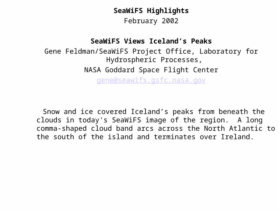
SeaWiFS Views Iceland’s Peaks
Gene Feldman/SeaWiFS Project Office, Laboratory for Hydrospheric Processes,
NASA Goddard Space Flight Center
Snow and ice covered Iceland’s peaks from beneath the clouds in today's SeaWiFS image of the region. A long comma-shaped cloud band arcs across the North Atlantic to the south of the island and terminates over Ireland.
SeaWiFS Views Iceland’s Peaks
Sydney
February 27, 2002
Continuing Development of the Global Land Data Assimilation System
Matthew Rodell, Paul Houser, Urszula Jambor, Jon Gottschalck, Jesse Meng, Kristi Arsenault
NASA GSFC, Laboratory for Hydrospheric Processes, Hydrological Sciences Branch,
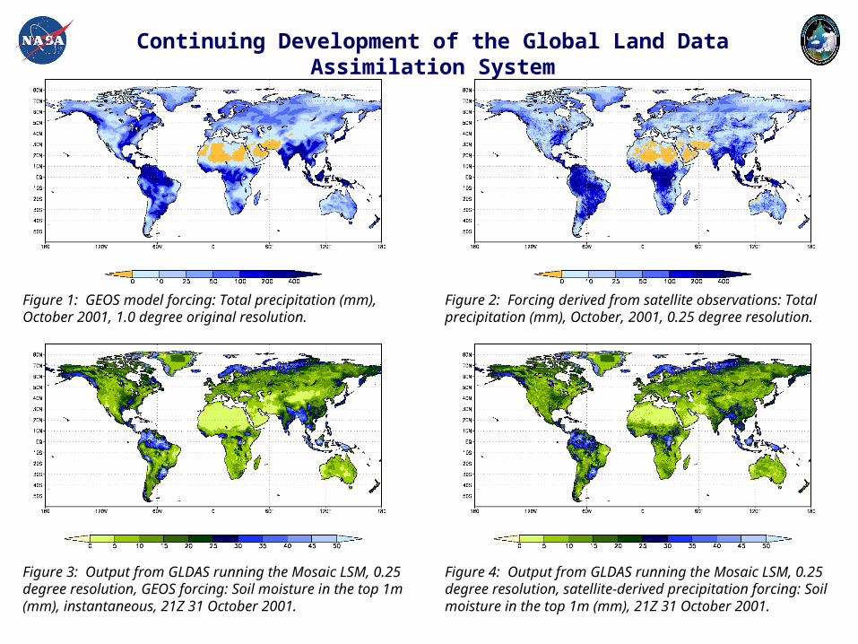
Background: The Global Land Data Assimilation System (GLDAS) project began in September, 2000, with the goal of producing reliable fields of land surface states and fluxes in near-real time. Surface stores of water and energy (e.g., soil moisture and temperature) regulate atmospheric conditions, so that accurate initialization of these states in weather and climate models is crucial for producing dependable predictions. However, accurate, global fields of land surface states are scarce, hence the motivation for developing a reliable, high resolution, near-real time GLDAS. By making use of data from advanced observing systems, including NASA and NOAA satellite remote sensors, to force and constrain offline (not coupled to an atmospheric model) land surface models (LSMs), GLDAS is able to avoid biases that are present in modeled atmospheric fields and which tend to accumulate as errors in the land surface states. The high-quality, assimilated, global land surface fields that GLDAS provides are valuable for agricultural, climatological, ecological, geophysical, and natural hazard related research and applications, as well as for GEWEX projects and hydrologic field campaigns.
Specifications: GLDAS runs globally at both 1/4 degree and 2 x 2.5 degree resolutions, typically on a 15 minute model timestep, with 3 hourly output. Drivers have been installed for the Mosaic LSM and the Community Land Model (CLM). Baseline atmospheric forcing comes from a choice of either NASA’s GEOS or NOAA’s GDAS global atmospheric forecast models. Observation-based precipitation and radiation fields replace the corresponding modeled forcing fields when and where they are available. The soil parameterization is based on a 5’ global soils map. GLDAS uses a 30 arc second global digital elevation model as its standard and corrects input fields accordingly. A vegetation-based “tiling” approach is used to simulate sub-grid scale variability, which is determined based on a 1 kilometer resolution, global vegetation classification dataset.
Recent Accomplishments and Future Objectives: A routine for dynamic vegetation parameter updates has been installed. A snow correction algorithm, which makes use of satellite observation based snow fields, is being tested. Implementation of a driver for NOAA’s NOAH LSM is nearly complete. Output from the atmospheric forecast model of the European Centre for Medium Range Weather Forecasts soon will be added to the suite of forcing options. Current objectives include testing various data assimilation routines, installing additional LSMs, linking a runoff routing scheme, and performing various scientific studies.
For more information, please visit http://ldas.gsfc.nasa.gov.
Continuing Development of the Global Land Data Assimilation System
Figure 2: Forcing derived from satellite observations: Total precipitation (mm), October, 2001, 0.25 degree resolution.
Figure 3: Output from GLDAS running the Mosaic LSM, 0.25 degree resolution, GEOS forcing: Soil moisture in the top 1m (mm), instantaneous, 21Z 31 October 2001.
Figure 1: GEOS model forcing: Total precipitation (mm), October 2001, 1.0 degree original resolution.
Figure 4: Output from GLDAS running the Mosaic LSM, 0.25 degree resolution, satellite-derived precipitation forcing: Soil moisture in the top 1m (mm), 21Z 31 October 2001.
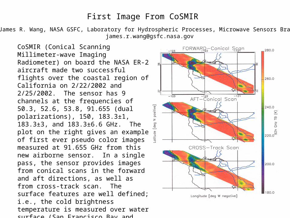
CoSMIR (Conical Scanning Millimeter-wave Imaging Radiometer) on board the NASA ER-2 aircraft made two successful flights over the coastal region of California on 2/22/2002 and 2/25/2002. The sensor has 9 channels at the frequencies of 50.3, 52.6, 53.8, 91.655 (dual polarizations), 150, 183.3±1, 183.3±3, and 183.3±6.6 GHz. The plot on the right gives an example of first ever pseudo color images measured at 91.655 GHz from this new airborne sensor. In a single pass, the sensor provides images from conical scans in the forward and aft directions, as well as from cross-track scan. The surface features are well defined; i.e., the cold brightness temperature is measured over water surface (San Francisco Bay and ocean area off the coast). The sensor’s capability to provide multiple views of surface features and atmospheric media will improve retrievals of parameters such as surface emissivity, ice water path of frozen hydrometeors.
First Image From CoSMIR
James R. Wang, NASA GSFC, Laboratory for Hydrospheric Processes, Microwave Sensors [email protected]