Embed Size (px)
Citation preview
Second Pond Boat Launch
Proposed Final Unit Management Plan/ Final Supplemental Environmental Impact Statement
Town of Harrietstown
Franklin County ANDREW CUOMO JOE MARTENS Governor Commissioner
NEW YORK STATE
Department of Environmental Conservation DIVISION OF OPERATIONS
For Further Information Contact: New York State Department of Environmental Conservation P.O. Box 296 1115 State Route 86 Ray Brook, NY 12977 Phone: (518) 897‐1310 December 2012

This page intentionally left blank
Table of Contents Introduction …………………………………………………………………….... 1 Description of the Facility …………………………………………………….…… 1 Setting of Surrounding Area ………………………………………………….……. 3 Recreational Use and Demand ……………………………………………….…….. 4 Carrying Capacity ………………………………………………………….………. 6 Management Objectives …………………………………………………….……… 7 Scope of Project Plan …………………………………………………….……….… 8 Proposed Map Changes ………………………………………………….…….…... 12 Conformity with the Adirondack Park State Land Master Plan …………….……... 13 Alternatives ………………………………………………………………………… 14 Appendices
I. Level of Vehicular Use Charts II. Proposed Boundary Adjustments & Wetlands Boundary III. Wetlands Impact & Mitigation Map IV. Screening, Shoreline Buffer & Tree Cutting Plan V. Design of Typical Firewood Storage Building VI. Design of Typical Registration Booth VII. American with Disabilities Act Assessment VIII. Soils Report IX. Public Comments

This page intentionally left blank
1
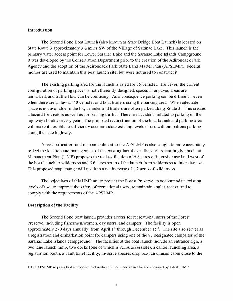
Introduction
The Second Pond Boat Launch (also known as State Bridge Boat Launch) is located on State Route 3 approximately 3½ miles SW of the Village of Saranac Lake. This launch is the primary water access point for Lower Saranac Lake and the Saranac Lake Islands Campground. It was developed by the Conservation Department prior to the creation of the Adirondack Park Agency and the adoption of the Adirondack Park State Land Master Plan (APSLMP). Federal monies are used to maintain this boat launch site, but were not used to construct it.
The existing parking area for the launch is rated for 75 vehicles. However, the current configuration of parking spaces is not efficiently designed, spaces in unpaved areas are unmarked, and traffic flow can be confusing. As a consequence parking can be difficult – even when there are as few as 40 vehicles and boat trailers using the parking area. When adequate space is not available in the lot, vehicles and trailers are often parked along Route 3. This creates a hazard for visitors as well as for passing traffic. There are accidents related to parking on the highway shoulder every year. The proposed reconstruction of the boat launch and parking area will make it possible to efficiently accommodate existing levels of use without patrons parking along the state highway.
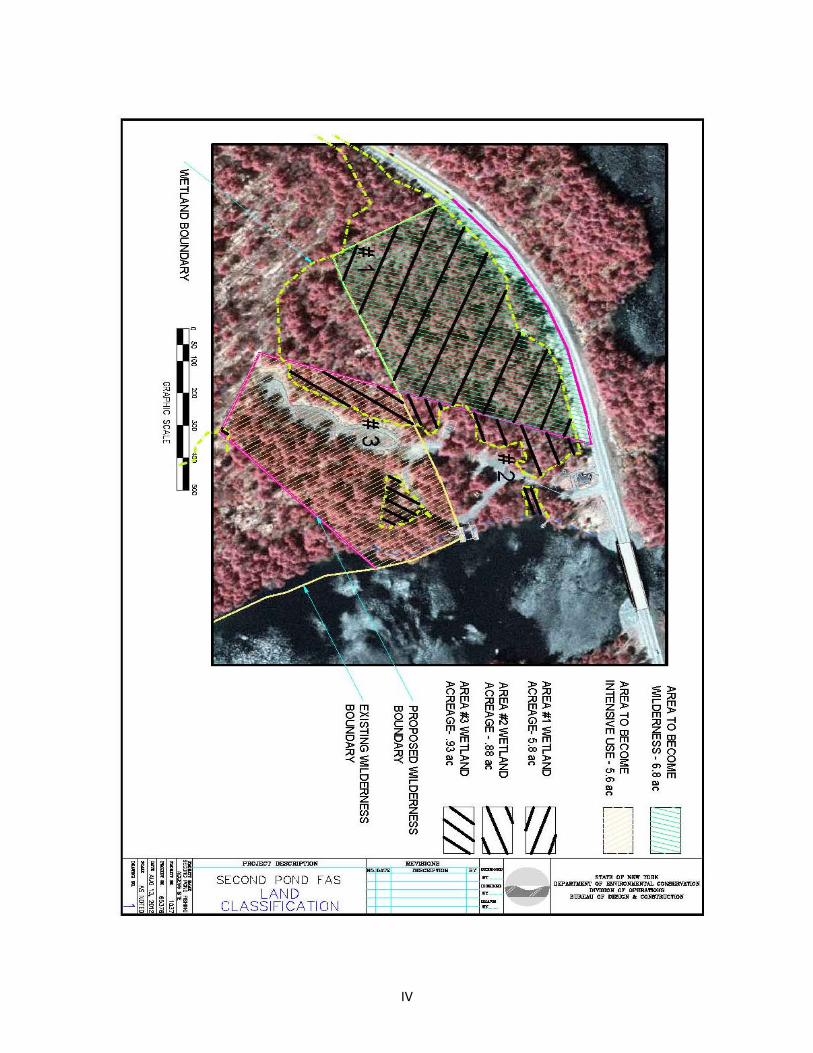
A reclassification1 and map amendment to the APSLMP is also sought to more accurately reflect the location and management of the existing facilities at the site. Accordingly, this Unit Management Plan (UMP) proposes the reclassification of 6.8 acres of intensive use land west of the boat launch to wilderness and 5.6 acres south of the launch from wilderness to intensive use. This proposed map change will result in a net increase of 1.2 acres of wilderness.
The objectives of this UMP are to protect the Forest Preserve, to accommodate existing
levels of use, to improve the safety of recreational users, to maintain angler access, and to comply with the requirements of the APSLMP. Description of the Facility
The Second Pond boat launch provides access for recreational users of the Forest Preserve, including fishermen/women, day users, and campers. The facility is open approximately 270 days annually, from April 1st through December 15th. The site also serves as a registration and embarkation point for campers using one of the 87 designated campsites of the Saranac Lake Islands campground. The facilities at the boat launch include an entrance sign, a two lane launch ramp, two docks (one of which is ADA accessible), a canoe launching area, a registration booth, a vault toilet facility, invasive species drop box, an unused cabin close to the
1 The APSLMP requires that a proposed reclassification to intensive use be accompanied by a draft UMP.
2
state highway, two paved parking areas, three gravel parking areas, and a dock for administrative use which is not open to the public.
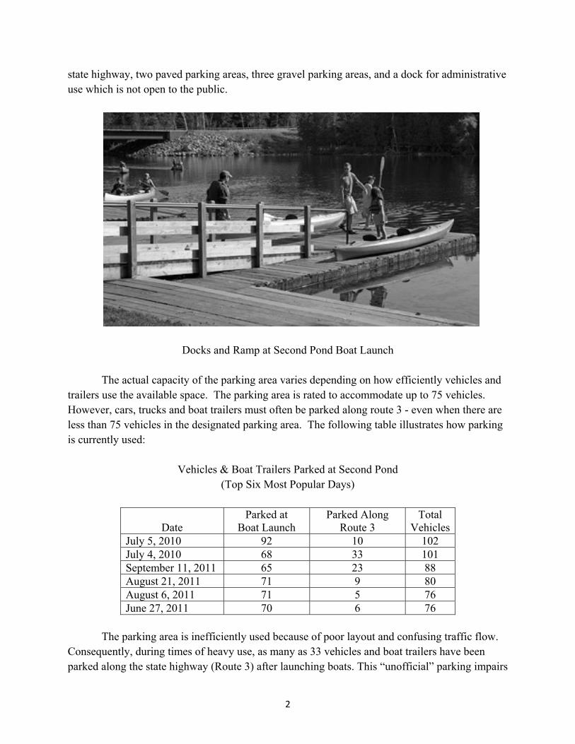
Docks and Ramp at Second Pond Boat Launch The actual capacity of the parking area varies depending on how efficiently vehicles and
trailers use the available space. The parking area is rated to accommodate up to 75 vehicles. However, cars, trucks and boat trailers must often be parked along route 3 - even when there are less than 75 vehicles in the designated parking area. The following table illustrates how parking is currently used:
Vehicles & Boat Trailers Parked at Second Pond (Top Six Most Popular Days)
Date Parked at
Boat Launch Parked Along
Route 3 Total
Vehicles July 5, 2010 92 10 102 July 4, 2010 68 33 101 September 11, 2011 65 23 88 August 21, 2011 71 9 80 August 6, 2011 71 5 76 June 27, 2011 70 6 76
The parking area is inefficiently used because of poor layout and confusing traffic flow.
Consequently, during times of heavy use, as many as 33 vehicles and boat trailers have been parked along the state highway (Route 3) after launching boats. This “unofficial” parking impairs
3
the scenic quality of the highway and creates a safety hazard for visitors as well as for thru traffic.
The boat docks at Second Pond have been in place for a number of years and are
beginning to deteriorate from weathering and recreational use. These docks also rest on the lake bottom (not floating) which makes them more difficult to use when water levels fluctuate. These docks will be replaced with a floating dock system.
The State Land map currently shows an intensive use area at this location. However the boundaries do not totally conform to the parking area as it actually exists. Part of the facility extends into an area classified as wilderness. Setting of Surrounding Area The Second Pond boat launch is bordered by Second Pond on the east State Route 3 to the north and west, and the High Peaks Wilderness area which is on the south. Except for the access road, boat launch, and parking area, the site is wooded with a mixture of northern hardwood species and occasional hemlock, spruce and white pine.
The Saranac River is designated as a recreational river under the Wild, Scenic and
Recreational Rivers Act. Second Pond is an 81 acre “widewater” of the Saranac River located a few miles west of the Village of Saranac Lake on the east side of Route 3. Second Pond averages only 3.3 feet in depth with a maximum depth of nine feet. Muck and sand comprise most of the bottom. Second Pond is contiguous with First Pond. The Route 3 highway bridge serves as the only distinguishing feature between the waters.
Unfortunately, Second Pond contains numerous invasive species. These invasives include
Eurasian water milfoil, curly leaf pondweed and variable leaf milfoil. Since milfoil accumulates near the shores in sandy areas, boats coming in and out of the launch are easily contaminated. Since milfoil and other aquatics spread by fragmentation, broken pieces of these plants can be easily transported to other lakes where they can become established. Paul Smiths College has assigned stewards to help control the spread of invasive aquatic vegetation at the boat launch through their Watershed Stewardship Program. There is also a nuisance invasive species disposal station at the site which provides guidance on preventing the spread of invasives and is a dedicated location for the disposal.
A 1984 ALSC2 survey and more recently a 2006 DEC fisheries survey caught the following fish species in order of abundance: yellow perch, brown bullhead, pumpkinseed, golden shiner, northern pike, white sucker, central mudminnow, longnose sucker, largemouth 2 Adirondack Lake Survey Corporation
4
bass, walleye, smallmouth bass, rock bass, fallfish, and rainbow smelt. Thick beds of submerged aquatic vegetation are common outside of the buoyed boating lanes in Second pond. Recreational Use and Demand
The Second Pond boat launch is one of the most popular access points to Lower Saranac Lake and to the Saranac Lake chain. On any given summer day, it is not uncommon for paddlers to be unloading cars dockside, while families register for camping stays and anglers, day users and campers share the launch. The use of the boat launch has been documented by various surveys in recent years. One of the most comprehensive was conducted on 15 weekends in 2005, 2008 and 2009 as part of Paul Smiths Watershed Stewardship Program. The following statistics were collected showing the total number of boats and the total number of recreational users:
Weekend Use of Second Pond Boat Launch
2005 20083 2009 Number of Boats 1,676 1,765 1,771 Number of People 3,691 3,223 3,405
It should be noted that between 2005 and 2009 there was a slight increase in the number
of boats using the site while the number of users actually declined. The appendix includes a table showing the use trends at several other boat launches in the Adirondacks between 2000 and 2009. Generally, boat launch use appears to be gradually trending higher over time.
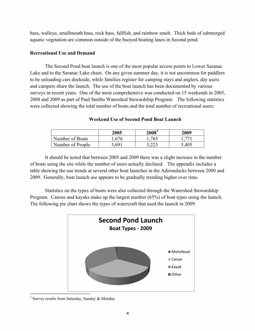
Statistics on the types of boats were also collected through the Watershed Stewardship
Program. Canoes and kayaks make up the largest number (65%) of boat types using the launch. The following pie chart shows the types of watercraft that used the launch in 2009.
3 Survey results from Saturday, Sunday & Monday
Second Pond LaunchBoat Types ‐ 2009
Mototboat
Canoe
Kayak
Other
5
The boat launch is the primary access point for the camping area on Lower and Middle Saranac Lakes. DEC surveys show that 79% of campers on Lower Saranac Lake and 45% campers on Middle Saranac Lake and Weller Pond put in at this location. This boat launch also provides access for day use to the Saranac River, Lower and Middle Saranac Lake, Weller Pond, Kiwassa Lake, Oseetah Lake, and Lake Flower.
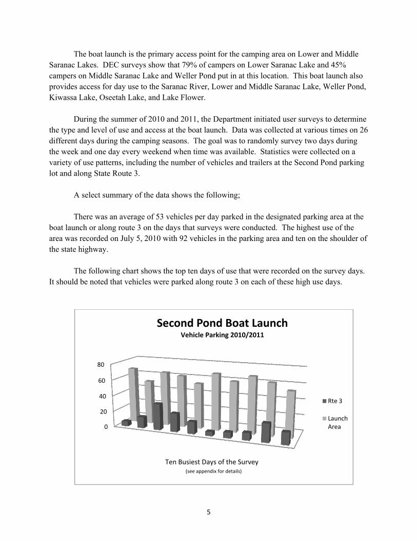
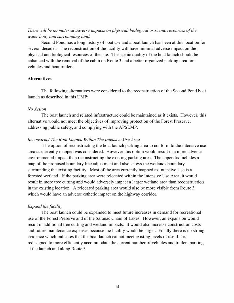
During the summer of 2010 and 2011, the Department initiated user surveys to determine
the type and level of use and access at the boat launch. Data was collected at various times on 26 different days during the camping seasons. The goal was to randomly survey two days during the week and one day every weekend when time was available. Statistics were collected on a variety of use patterns, including the number of vehicles and trailers at the Second Pond parking lot and along State Route 3.
A select summary of the data shows the following;
There was an average of 53 vehicles per day parked in the designated parking area at the boat launch or along route 3 on the days that surveys were conducted. The highest use of the area was recorded on July 5, 2010 with 92 vehicles in the parking area and ten on the shoulder of the state highway.
The following chart shows the top ten days of use that were recorded on the survey days. It should be noted that vehicles were parked along route 3 on each of these high use days.
0
20
40
60
80
Second Pond Boat LaunchVehicle Parking 2010/2011
Rte 3
Launch Area
Ten Busiest Days of the Survey (see appendix for details)
6
Carrying Capacity
The ASLMP requires an assessment of the physical, biological and social carrying capacity of the area with particular attention to threats of overuse. The term carrying capacity has its roots in range and wildlife sciences and defines carrying capacity as “the maximum number of animals that can be grazed on a land unit for a specific period of time without inducing damage to the vegetation or related resources” (Arthur Carhart National Wilderness Training Center, 1994). In decades past, this concept was used to address recreational use impacts. This added human component broadened the concept of carrying capacity to include both ecological and social components. However, the relationship between the amount of recreational use and recreational impacts are not linear (Krumpe and Stokes, 1993). That is, for many recreational activities most impacts occur with only low levels of use. In addition, recreation managers now know that understanding impacts is complicated, as numerous impacts need to be included in the assessment including visitor behavior, site resistance and resiliency, and type of use.
As part of the Unit management planning process, the APSLMP requires UMPs to include an assessment of carrying capacity. In addition, the APSLMP requires an assessment of the capacity of Adirondack lakes and ponds to withstand use, particularly those that have existing intensive use facilities. These required assessments can be completed using a Limits of Acceptable Change (LAC) process.
The amount of recreational impacts within the Intensive use area at Second Pond Boat launch will be minimal as much of the area has durable surfaces, such as pavement or gravel. However, the Second Pond Boat Launch is a key access point to the waters and lands of the Saranac Lakes Wild Forest, and this area also has many large private parcels and access points with significant development which will further complicate the assessment.
Carrying capacity can be thought of as a threshold that, if exceeded, would lead to an undesirable set of conditions or problems. Carrying capacity can pertain to everything from pollutant loading, to habitat loss, to crowding. In August of 2011, SUNY College of Environmental Science and Forestry published a report, Adirondack Park Forest Preserve Carrying Capacity of Water Bodies Study: Phase I – Selecting Indicators for Monitoring Recreational Impacts (http://www.esf.edu/nywild/publications/docs/carrying-capacity.pdf). The study recommends measurement of eight types of ecological indicators, nine types of social impact indicators, three types of recreation use estimation indicators, and five types of recreation use and development indicators. Measurement of these indicators can form the basis to assist in determining Limits of Acceptable Change. The study proposes three more phases to fully develop a systematic approach to monitoring impacts.
In the case of Second Pond Boat Launch, the threshold of concern relates to how the
parking area impacts the carrying capacity of the water body where the recreation takes place.
7
The carrying capacity of a water body is very difficult to determine. There are many variables to consider, such as: the shoreline configuration of the lake, the level of development on the surrounding lands, the sizes and types of water craft operated, and type of recreation enjoyed. The number of all the boats in operation at one time on the water body would be the critical factor determining if the carrying capacity is being exceeded. The changes proposed in this UMP are not expected to materially change that number of boats that are being operated at any given time over all the water bodies that can be accessed from the Second Pond Boat Launch. This site’s (Second Pond Boat Launch Site) carrying capacity will therefore be developed as a part of the Saranac Wild Forest UMP. Although they have different land classifications (Intensive use and Wild Forest), the Saranac Lake Wild Forest and Second Pond BLS are integral, and if conditions on the waters and lands of the Saranac Lakes Wild Forest are found to be outside acceptable limits, changes to the management of the Second Pond Intensive Use Area may be required.
Surveys were randomly conducted on 26 days in 2010 and 2011 during the summer
season. The parking area adequately accommodated use about half of the time. However, on high use days vehicles were often parked along Route 3. Redesign and reconstruction of the parking area will enable the facility to safely accommodate existing levels of use. Management Objectives: The management objectives for the Second Pond Boat Launch are the following:
1. Protect the site and surrounding lands & waters of the Forest Preserve.
2. Provide for the safety of recreational users and vehicular traffic on Route 3.
3. Improve access for visitors with disabilities (see appendix VII)
4. Inventory and control of aquatic and terrestrial invasive species.
5. Provide more efficient use of the developed parking area.
6. Make the facility compliant with the APSLMP.
8
Scope of Project Plan
The Second Pond Boat is one of the most heavily used access points to the Saranac Chain of Lakes. It has been decades since any major repair or rehabilitation has been done. Accordingly, the following improvements are proposed.
The concrete launch ramp at Second Pond was installed many years ago and does not
meet current design standards. The existing ramp does not extend far enough into deep water and trailer wheels tend to drop off at the end of the ramp. Consequently, a scour hole has developed which can damage boat trailers in the launching process. One of the objectives in this reconstruction is to replace the ramp in order to provide a safer and more usable launch. A double-ramped boat launch with a turnaround for vehicles is proposed along with approximately 100 parking spaces.
The fixed wooden docks which are used for boats, canoes, kayaks and other watercraft
require extensive repairs. The project plan calls for the replacement of the existing structure with ADA compliant floating docks that will more easily accommodate boaters as water levels rise or fall during the season. The docks will be covered with wood and use brown and earth tone color combinations in keeping with the rustic appearance of other structures in the Forest Preserve. In addition the canoe and kayak launching site adjacent to the floating docks will be restored to natural conditions. The cribbing that is currently at the launch site will be removed. The overall footprint of the existing dock and launching area will be decreased by these actions.
The log cabin on Route 3 south of the entrance is dilapidated and no longer needed for
administrative purposes. This structure will be taken down and removed. The site will be graded and re-vegetated.
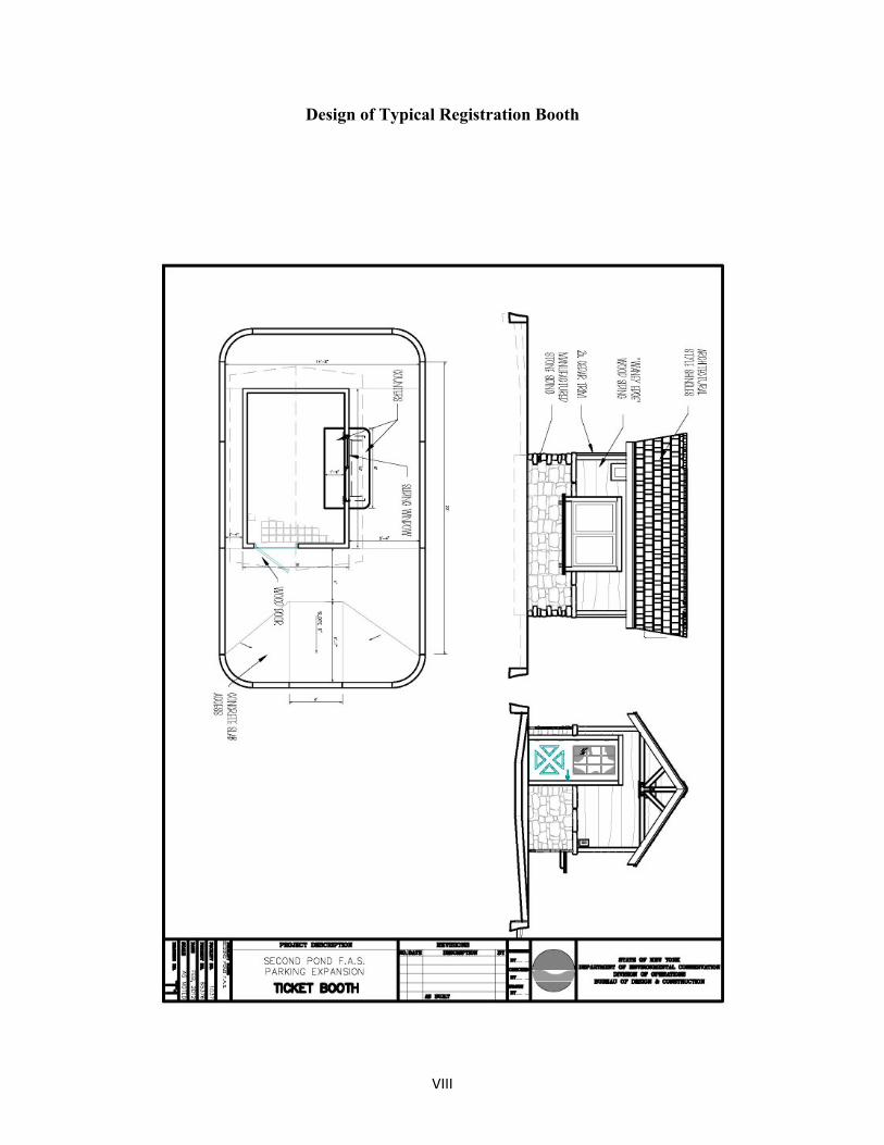
A new booth will be constructed near the launch area. This will be used by DEC staff to
register campers and to monitor the boat launch. The building will be approximately 8’ by 12’ including a small office and equipment storage area. No overnight accommodations will be included. The building will be constructed of wood and be designed and painted/stained to be esthetically compatible with similar structures on the Forest Preserve (see appendix VI). The booth building will meet the 150’ set back requirements from the mean high water mark.
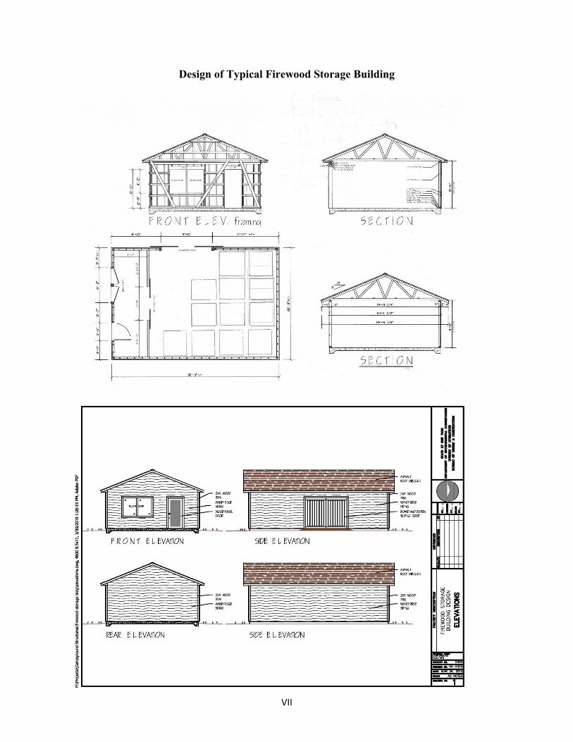
A firewood storage building, approximately 20' x 30', will be constructed near the
registration booth, and will comply with the 150’ set back from the mean high water mark. Campfires are an important part of the Forest Preserve recreational experience, and providing either local or treated firewood at this site will serve campers who stay at one of the developed campsites or elsewhere in the Forest Preserve. The sale of firewood will lessen the burden on the legal use of dead and downed wood in the area, and reduces the likelihood of campers
9
transporting damaging forest pests in untreated wood brought in from elsewhere. The building will be constructed of wood and be designed and painted/stained to be esthetically compatible with similar structures on the Forest Preserve.
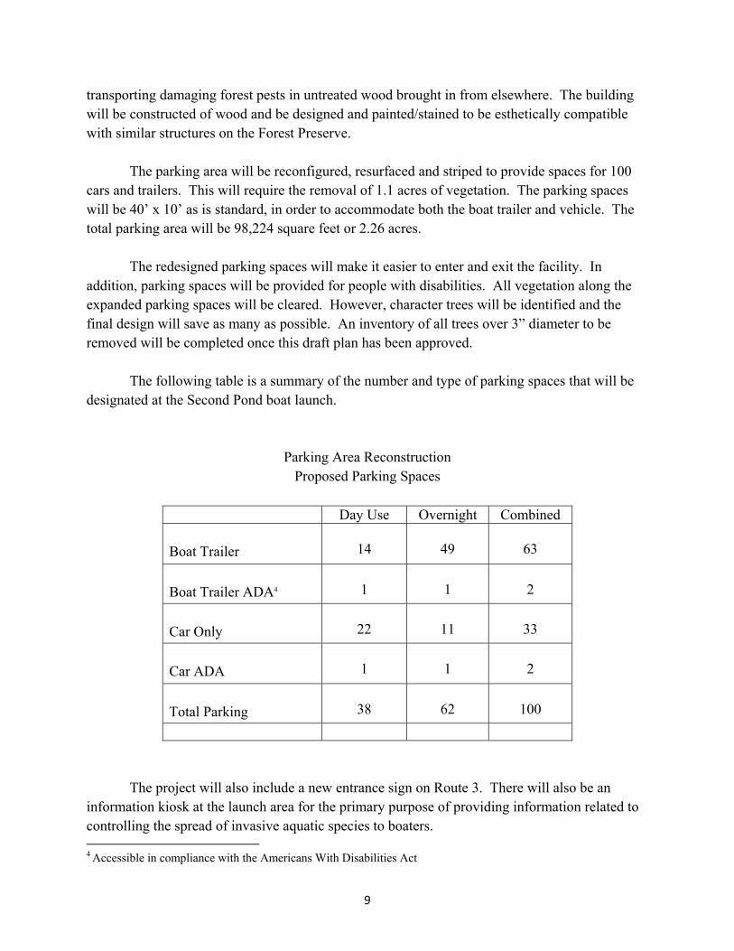
The parking area will be reconfigured, resurfaced and striped to provide spaces for 100
cars and trailers. This will require the removal of 1.1 acres of vegetation. The parking spaces will be 40’ x 10’ as is standard, in order to accommodate both the boat trailer and vehicle. The total parking area will be 98,224 square feet or 2.26 acres.
The redesigned parking spaces will make it easier to enter and exit the facility. In
addition, parking spaces will be provided for people with disabilities. All vegetation along the expanded parking spaces will be cleared. However, character trees will be identified and the final design will save as many as possible. An inventory of all trees over 3” diameter to be removed will be completed once this draft plan has been approved.
The following table is a summary of the number and type of parking spaces that will be
designated at the Second Pond boat launch.
Parking Area Reconstruction Proposed Parking Spaces
Day Use Overnight Combined Boat Trailer
14
49
63
Boat Trailer ADA4
1
1
2
Car Only
22
11
33
Car ADA
1
1
2
Total Parking
38
62
100
The project will also include a new entrance sign on Route 3. There will also be an
information kiosk at the launch area for the primary purpose of providing information related to controlling the spread of invasive aquatic species to boaters. 4 Accessible in compliance with the Americans With Disabilities Act
10
Reconstruct the existing vault comfort station which is located at the south end of the parking area to improve its operation. The scope of the reconstruction will be determined later, depending on budget considerations. The comfort station will be accessible and no barriers will be located between the parking spaces and the boat ramp so that visitors with disabilities will have access to the boat 1aunch. The building will have a rustic wood exterior and be designed and painted/stained to be esthetically compatible with similar structures on the Forest Preserve. Rehabilitation to this structure will maintain the same or lesser footprint of the current structure and meet ADA standards. Options being considered are composting toilets or above ground pumpable vault units. The main factor in the rehab of this facility is controlling odor and sanitation issues that have caused users to utilize the surrounding forest and wetlands.
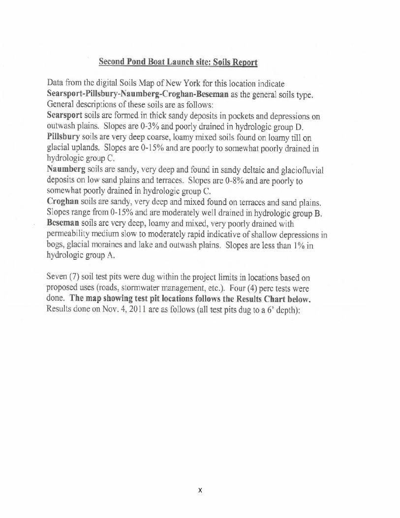
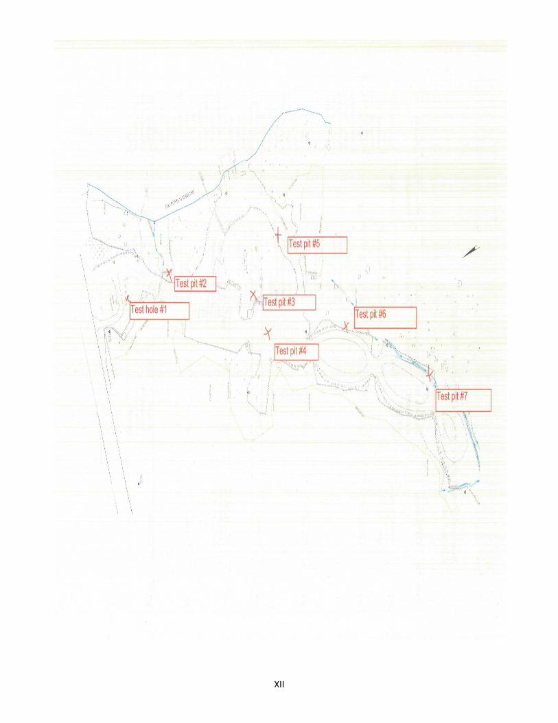
Soils at Second Pond BLS are Searsport-Pillsbury-Naumberg-Croghan-Beseman. Soil
types where taken from the Digital soils map of New York and visual inspection by Department staff. Seven soil test pits where dug at this location based on proposed uses, and four percolation tests were done (see appendix VIII for data and results).
A storm water control plan will be implemented so as to prevent erosion. Ditches, culverts and the seeding of grass will be used as needed. The storm water design will meet current DEC storm water regulations.
A wetland will be constructed at the south end of the parking lot to mitigate the loss of
several small wet areas which will be necessary as part of the reconstruction of the parking area. Wetland mitigation(s) will be designed and approved in consultation with APA staff prior to construction. The Division of Operations will obtain all necessary Federal and State permits where necessary to accomplish the tasks and objectives outlined in this plan. Any regulated activity which may involve a freshwater wetland will not be undertaken prior to consultation and agreement with the Agency, and if required a permit by the Agency.
Department staff will work with DOT to prohibit parking along State Route 3 near the boat launch. Onsite parking will be enforced by DEC staff.
Invasive species control signage and informational handouts will be implemented at this
site, through the control booth and kiosk(s) points. As well as an invasive species disposal box provided at the launch. The Department plans on continuing to provide space for the Lake Stewards Program administered by Paul Smiths College at this site. Staff whom works at the launch for administration of the Campground will continue to be trained in the identification and control of invasives to further educate the public and actively prevent further spreading. Use of a boat wash station was also considered for this site. The Department may consider the option of a boat wash station, in the future should resources become available at this site and it is determined that it will be more effective in controlling the spread of invasives than the current disposal
11
stations that are provided. In addition terrestrial invasives have been identified at the site behind the old DOT cabin (Japanese Knotweed). This patch will be removed during construction and replaced with native vegetation from the areas being cleared for construction. Future monitoring of the site will be conducted by Department staff to assure eradication and prevention of other species moving in.
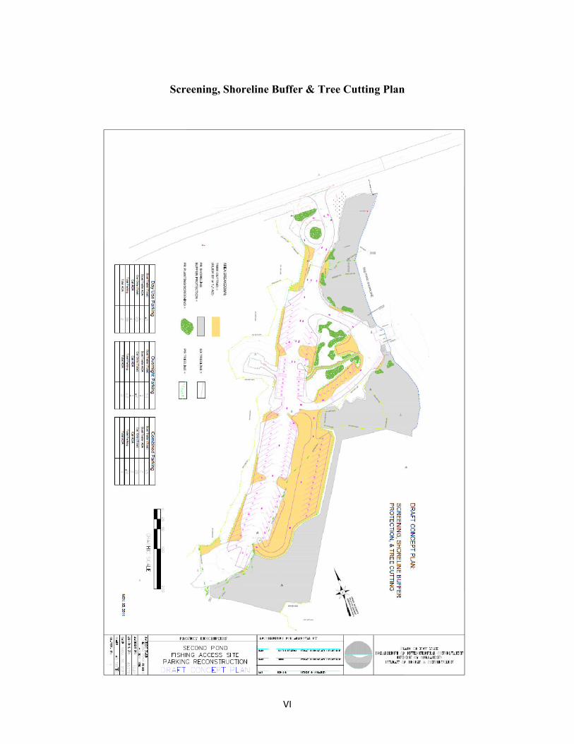
The Department will maintain and improve vegetative screenings and buffers along the
highway and Second Pond as necessary. All planting species used on this project will come from the APA native plant list. Exceptions may occur in cases where some may be unavailable, in which case, any alternate species will be agreed on ahead of time with APA. Protective screening will consist of new plantings to both frame desired views and block undesired views as well as to enhance certain areas (i.e. entrance area from Rt. 3). When and where possible plants removed from the site due to construction will be saved and replanted in the screening and re-vegetation areas.
Construction for the site is expected to start after Labor Day 2012 assuming there is an approved UMP and design specification for the project, but could be delayed to fall 2013 depending on other Agency/Executive approvals. The launch will be fully closed to the public during construction and displaced users will be directed to; Lake Flower, South Creek, Ampersand Bay, or one of the private marinas for lake access. Due to lower use levels in the fall this is not expected to have a major impact on public access. Construction is expected to be completed by outside contract.
Benefits of the proposed improvements include;
• Improved traffic flow and better use of existing space • Improve/expand accessible parking • Planting native vegetation to improve visual screening of the facility from both the water
and State Route 3. Visual improvement will also be provided by removing the old cabin along State Route 3 and by the use of floating docks that can be seasonally removed.
• Improving safety by reducing and/or eliminating parking along State Route 35 by vehicles, trailers and combinations thereof.
• Visitor experience will be greatly improved by rehabilitating the vault toilet and enhancing facilities for hand launching.
• Improved education and control and or removal of invasive species. • Reducing storm water runoff through the use of pervious pavement is being evaluated as
a design alternative. 5 NYSDOT has been consulted and is willing to work with the Department to develop infrastructure improvements (guardrails, etc.) that will prohibit roadside parking where desired.
12
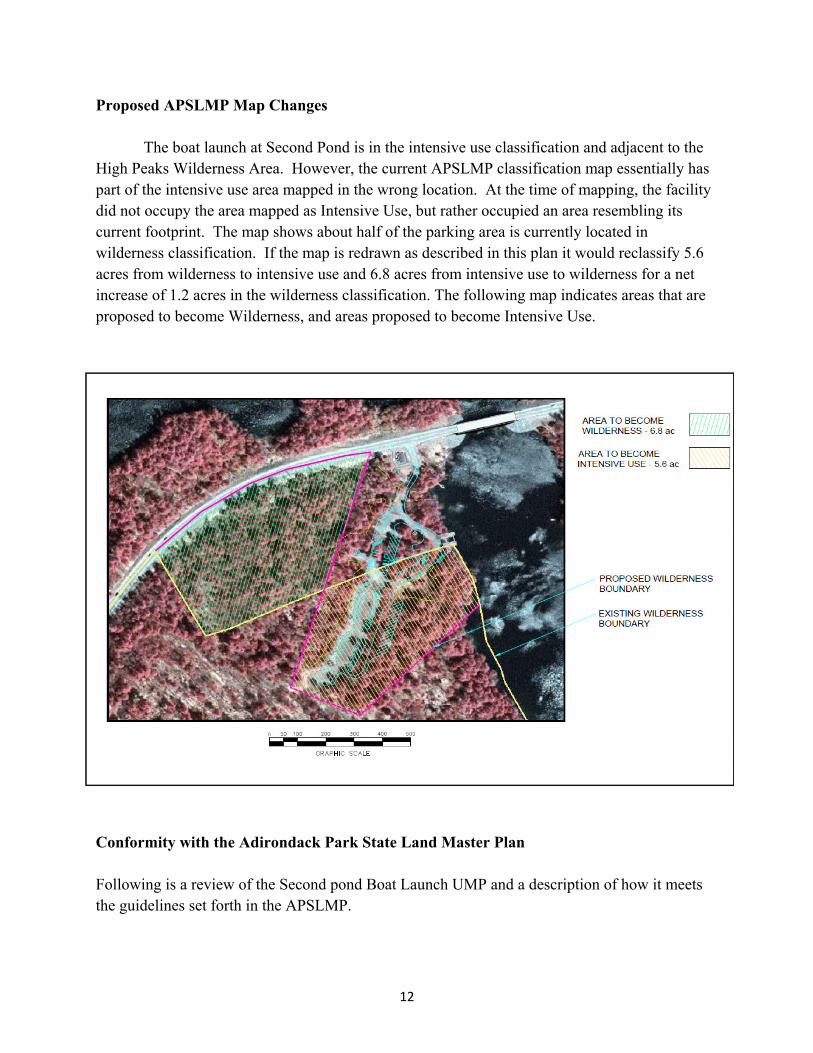
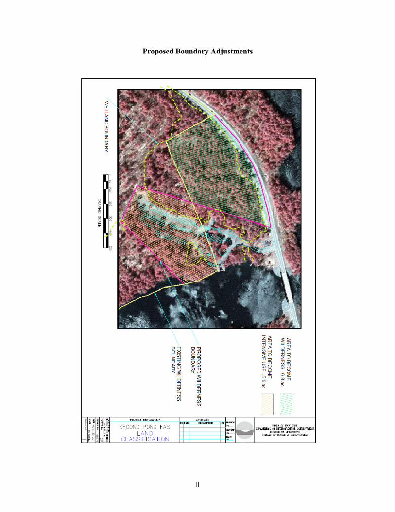
Proposed APSLMP Map Changes The boat launch at Second Pond is in the intensive use classification and adjacent to the High Peaks Wilderness Area. However, the current APSLMP classification map essentially has part of the intensive use area mapped in the wrong location. At the time of mapping, the facility did not occupy the area mapped as Intensive Use, but rather occupied an area resembling its current footprint. The map shows about half of the parking area is currently located in wilderness classification. If the map is redrawn as described in this plan it would reclassify 5.6 acres from wilderness to intensive use and 6.8 acres from intensive use to wilderness for a net increase of 1.2 acres in the wilderness classification. The following map indicates areas that are proposed to become Wilderness, and areas proposed to become Intensive Use.
Conformity with the Adirondack Park State Land Master Plan Following is a review of the Second pond Boat Launch UMP and a description of how it meets the guidelines set forth in the APSLMP.
13
Location in an Intensive Use Area. The existing boat launch parking area is partially located in Wilderness. The map
correction proposed in this plan will resolve this conflict with the APSLMP, reclassifying that portion of the parking area that is located in Wilderness as Intensive Use. Location on a lake or waterway exceeding 1000 acres in area.
According to the APSLMP, boat launch sites should be located on large lakes, or smaller lakes connected by navigable waterways where the aggregate acreage of the lake chain exceeds 1,000 acres. Second Pond is part of the Saranac Chain which is one of the interconnected waterways listed in the APSLMP which exceeds 1,000 acres. The physical, biological and social carrying capacity will not be exceeded.
The physical and social carrying capacity of Second pond for boating was discussed earlier in this plan. Biological thresholds should not be exceeded since this plan does not propose to increase the level of current use. With respect to social carrying capacity, boats of all types are generally accepted on Second Pond and the Saranac Chain. The Second Pond Boat Launch is an integral part of the local social infrastructure and provides a recreational asset to the community. The boat launching site or attendant water uses will be compatible with the state or private land use classifications and attendant management guidelines as land use controls surrounding the water body.
The Second Pond Boat Launch is classified as Intensive Use. The surrounding area includes both Wilderness and Wild Forest and State Route 3 is classified as a Travel Corridor. Private land classifications on the waterway include rural use along the southern shore of Second pond and low intensity and moderate intensity use around the Village of Saranac Lake. The boat launching site is located in a manner to avoid adverse impact on adjacent or nearby state and private lands.
The Second pond Boat Launch is ideally located to reduce adverse impacts on adjacent lands. It is located on a sheltered pond, removed from private lands and within easy sight of State Route 3. Its location with easy access from the highway facilitates enforcement and administration of the facility. The parking area as proposed will minimize the impact of vehicular traffic on the site and eliminate the adverse impacts associated with parking along Route 3. Motor size limitations appropriate to the carrying capacity of the lake are provided.
Currently, there is no motor size limitation on Second pond. The launch is adequate for launching most boats. Although Second Pond is a small lake, it provides access to much larger lakes that are suitable for motorboats.
14
There will be no material adverse impacts on physical, biological or scenic resources of the water body and surrounding land.
Second Pond has a long history of boat use and a boat launch has been at this location for several decades. The reconstruction of the facility will have minimal adverse impact on the physical and biological resources of the site. The scenic quality of the boat launch should be enhanced with the removal of the cabin on Route 3 and a better organized parking area for vehicles and boat trailers.
Alternatives The following alternatives were considered to the reconstruction of the Second Pond boat launch as described in this UMP: No Action
The boat launch and related infrastructure could be maintained as it exists. However, this alternative would not meet the objectives of improving protection of the Forest Preserve, addressing public safety, and complying with the APSLMP.
Reconstruct The Boat Launch Within The Intensive Use Area
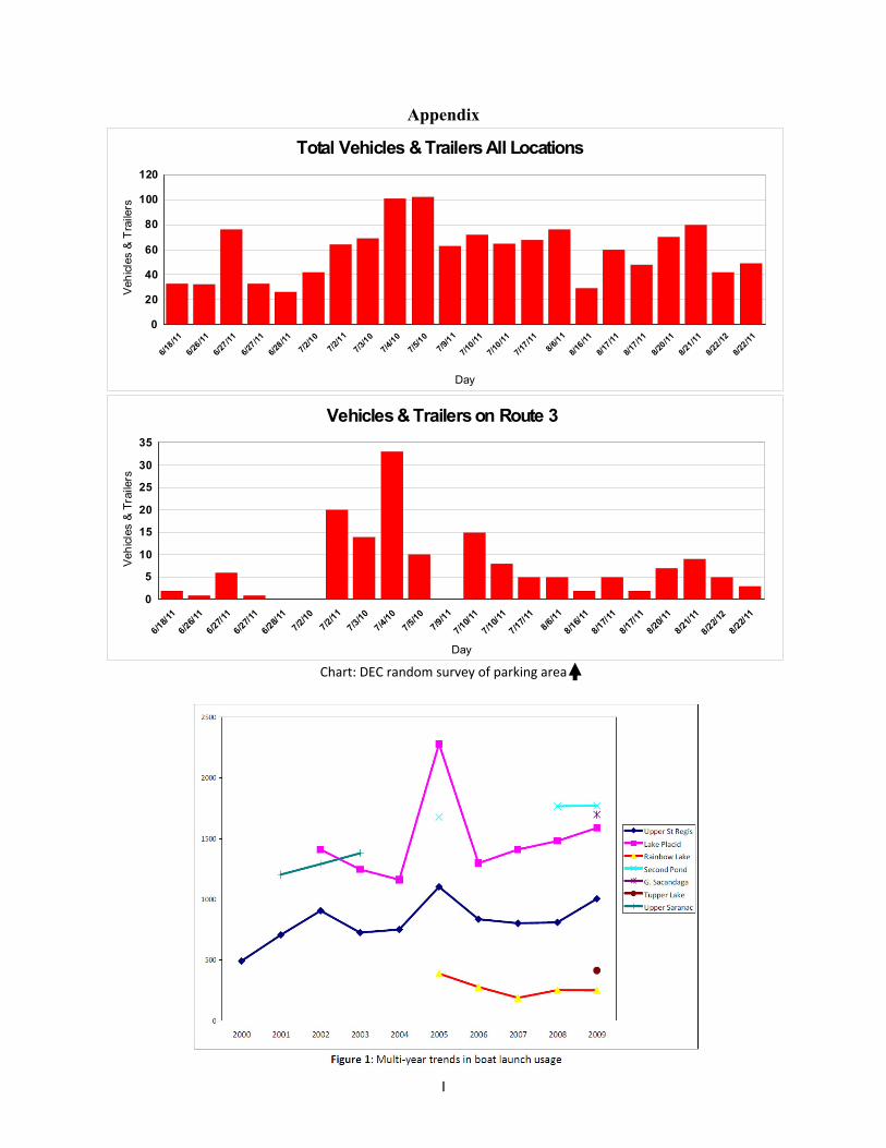
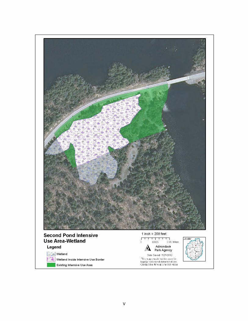
The option of reconstructing the boat launch parking area to conform to the intensive use area as currently mapped was considered. However this option would result in a more adverse environmental impact than reconstructing the existing parking area. The appendix includes a map of the proposed boundary line adjustment and also shows the wetlands boundary surrounding the existing facility. Most of the area currently mapped as Intensive Use is a forested wetland. If the parking area were relocated within the Intensive Use Area, it would result in more tree cutting and would adversely impact a larger wetland area than reconstruction in the existing location. A relocated parking area would also be more visible from Route 3 which would have an adverse esthetic impact on the highway corridor.
Expand the facility The boat launch could be expanded to meet future increases in demand for recreational use of the Forest Preserve and of the Saranac Chain of Lakes. However, an expansion would result in additional tree cutting and wetland impacts. It would also increase construction costs and future maintenance expenses because the facility would be larger. Finally there is no strong evidence which indicates that the boat launch cannot meet existing levels of use if it is redesigned to more efficiently accommodate the current number of vehicles and trailers parking at the launch and along Route 3.

15
Reduce the facility The boat launch could be reduced in size, which may result in the parking problem being
pushed to other areas, such as the Village of Saranac Lake. It is not certain that this option will result in even a slight decrease in the number of boats being operated on the water complex at one time, since people could use another access location and any reduction in access from a public facility could be made up for by an increase in access from private facilities.

16
This page intentionally left blank
I
6/18/11
6/26/11
6/27/11
6/27/11
6/28/11
7/2/10
7/2/11
7/3/10
7/4/10
7/5/10
7/9/11
7/10/11
7/10/11
7/17/11
8/6/11
8/16/11
8/17/11
8/17/11
8/20/11
8/21/11
8/22/12
8/22/11
Day
0
20
40
60
80
100
120
Veh
icles
& T
raile
rs
Total Vehicles & Trailers All Locations
6/18/1
1
6/26/1
1
6/27/1
1
6/27/1
1
6/28/1
17/2
/107/2
/117/3
/107/4
/107/5
/107/9
/11
7/10/1
1
7/10/1
1
7/17/11
8/6/11
8/16/11
8/17/1
1
8/17/1
1
8/20/1
1
8/21/1
1
8/22/1
2
8/22/1
1
Day
0
5
10
15
20
25
30
35
Veh
icle
s &
Tra
ilers
Vehicles & Trailers on Route 3
Appendix
Chart: DEC random survey of parking area
II
Proposed Boundary Adjustments
III
Wetlands Impact & Mitigation Map
IV
V
VI
Screening, Shoreline Buffer & Tree Cutting Plan
VII
Design of Typical Firewood Storage Building
VIII
Design of Typical Registration Booth
IX
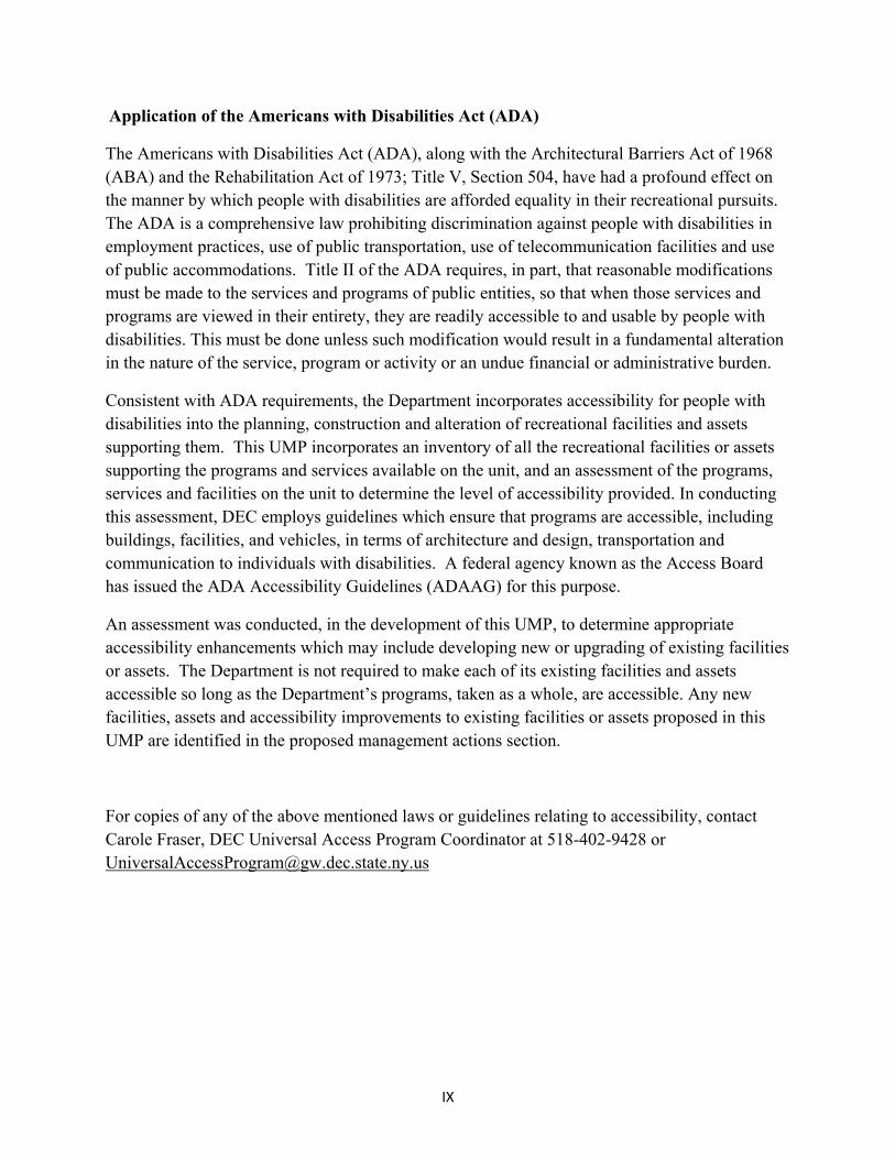
Application of the Americans with Disabilities Act (ADA)
The Americans with Disabilities Act (ADA), along with the Architectural Barriers Act of 1968 (ABA) and the Rehabilitation Act of 1973; Title V, Section 504, have had a profound effect on the manner by which people with disabilities are afforded equality in their recreational pursuits. The ADA is a comprehensive law prohibiting discrimination against people with disabilities in employment practices, use of public transportation, use of telecommunication facilities and use of public accommodations. Title II of the ADA requires, in part, that reasonable modifications must be made to the services and programs of public entities, so that when those services and programs are viewed in their entirety, they are readily accessible to and usable by people with disabilities. This must be done unless such modification would result in a fundamental alteration in the nature of the service, program or activity or an undue financial or administrative burden.
Consistent with ADA requirements, the Department incorporates accessibility for people with disabilities into the planning, construction and alteration of recreational facilities and assets supporting them. This UMP incorporates an inventory of all the recreational facilities or assets supporting the programs and services available on the unit, and an assessment of the programs, services and facilities on the unit to determine the level of accessibility provided. In conducting this assessment, DEC employs guidelines which ensure that programs are accessible, including buildings, facilities, and vehicles, in terms of architecture and design, transportation and communication to individuals with disabilities. A federal agency known as the Access Board has issued the ADA Accessibility Guidelines (ADAAG) for this purpose.
An assessment was conducted, in the development of this UMP, to determine appropriate accessibility enhancements which may include developing new or upgrading of existing facilities or assets. The Department is not required to make each of its existing facilities and assets accessible so long as the Department’s programs, taken as a whole, are accessible. Any new facilities, assets and accessibility improvements to existing facilities or assets proposed in this UMP are identified in the proposed management actions section.
For copies of any of the above mentioned laws or guidelines relating to accessibility, contact Carole Fraser, DEC Universal Access Program Coordinator at 518-402-9428 or [email protected]
X
XI
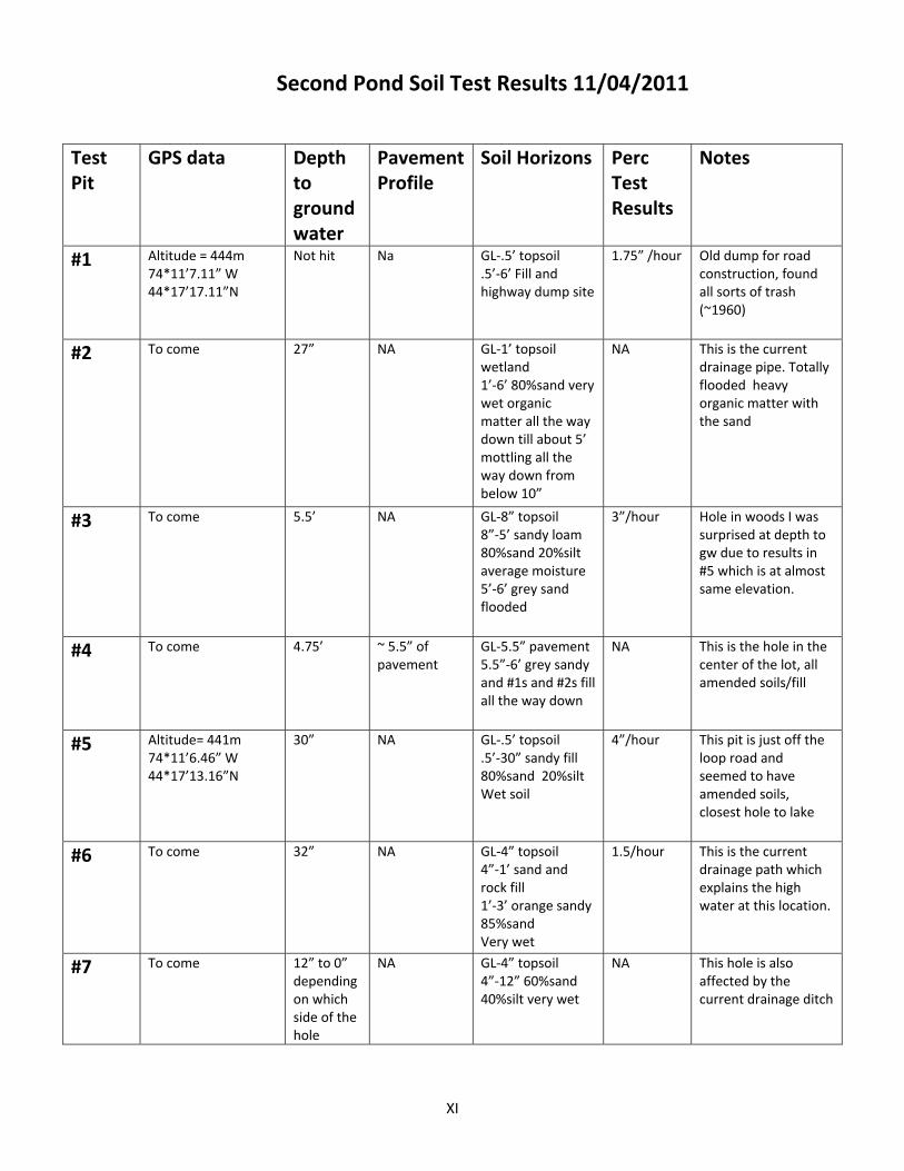
Second Pond Soil Test Results 11/04/2011
Test Pit
GPS data Depth to ground water
Pavement Profile
Soil Horizons Perc Test Results
Notes
#1 Altitude = 444m 74*11’7.11” W 44*17’17.11”N
Not hit Na GL‐.5’ topsoil.5’‐6’ Fill and highway dump site
1.75” /hour Old dump for road construction, found all sorts of trash (~1960)
#2 To come 27” NA GL‐1’ topsoil wetland 1’‐6’ 80%sand very wet organic matter all the way down till about 5’ mottling all the way down from below 10”
NA This is the current drainage pipe. Totally flooded heavy organic matter with the sand
#3 To come 5.5’ NA GL‐8” topsoil8”‐5’ sandy loam 80%sand 20%silt average moisture 5’‐6’ grey sand flooded
3”/hour Hole in woods I was surprised at depth to gw due to results in #5 which is at almost same elevation.
#4 To come 4.75’ ~ 5.5” of pavement
GL‐5.5” pavement5.5”‐6’ grey sandy and #1s and #2s fill all the way down
NA This is the hole in the center of the lot, all amended soils/fill
#5 Altitude= 441m 74*11’6.46” W 44*17’13.16”N
30” NA GL‐.5’ topsoil.5’‐30” sandy fill 80%sand 20%silt Wet soil
4”/hour This pit is just off the loop road and seemed to have amended soils, closest hole to lake
#6 To come 32” NA GL‐4” topsoil4”‐1’ sand and rock fill 1’‐3’ orange sandy 85%sand Very wet
1.5/hour This is the current drainage path which explains the high water at this location.
#7 To come 12” to 0” depending on which side of the hole
NA GL‐4” topsoil4”‐12” 60%sand 40%silt very wet
NA This hole is also affected by the current drainage ditch
XII
XIII
Appendix ( IX) – Public Comments
Comments on the 2012 Draft UMP
The following is a summary of public comments received between June 27th 2012 and July 31st 2012, following the release of the Draft SPBLS UMP and SEIS. The Department received only 3 comment letters, and 6 oral comments from the public meetings. Comments have been grouped according and addressed as general comments. All comments are attached for review at the end of this appendix.
Comment: Would like to see accommodations for fishermen and day‐users to park.
Response: Parking during the camping season will be monitored and enforced by DEC personnel, with some spaces being designated for day‐users and others for campers (see appendix IV for breakup of spaces).
Comment: Can you expand the parking area to fit more vehicles than the proposed design in the UMP.
Response: The Department recognizes the possibility of needs for expansion at this location and will not rule this out as an option if resources and conditions permit it. The Adirondack Park State Land Master Plan requires each unit management plan include an assessment of the carrying capacity. The Saranac Lakes Wild Forest Unit Management Plan has not been completed, nor has the required carrying capacity assessment to assess current use levels. Before additional parking can be considered beyond the existing levels, a carrying capacity assessment is needed to assist in managing social and biological resources of the Saranac Lakes Wild Forest. The level of parking proposed in this plan will accommodate the existing levels of public use, based on DEC surveys conducted during the summers of 2010 and 2011.
Comments: Accessible parking should be closer to launch area.
Response: In the new design accessible parking is closer to the launch area and spaces have been increased to meet ADA standards.
Comments: Provide a launch area for car‐top and paddlers.
Response: The natural sand area to the south of the launch ramp will be stabilized and marked for car top launching, with a loading and unloading area.
XIV
Comments: Provide details of the boat launch, perhaps engineer’s drawings.
Response: The design standards for the boat launch ramp and docks are from the Design Handbook for Recreational Boating and Fishing Facilities STATES ORGANIZATION FOR BOATING ACCESS (SOBA) SECOND EDITION May 2006, and 2010 ADA Standards for Accessible Design, Department of Justice September 15, 2010.
Comment: Remove the old DOT or Ranger cabin that is at the entrance just off route 3.
Response: The DOT has transferred this cabin to DEC, and it is schedule for demolition in this project.
Comment: DEC needs to allow parking on the road sides still.
Response: DEC will work cooperatively with DOT to identify areas that are acceptable for roadside parking. One of the objectives of this UMP is to improve safety at the site, and get parking off of State Route 3.
Comment: DEC should not be selling firewood.
Response: DEC only offers firewood for sale when doing so is necessary to supplement the existing supply offered by private vendors. The goal is to ensure reliable firewood at this destination to reduce the likelihood of visitors moving firewood that can potentially harm the natural resources in the area.
Comment: The DEC should be installing a boat wash station for control of invasives at this location.
Response: The Department will consider the option for a boat wash station at this location should resources become available, and advancements in the technology to make it a more feasible method of control. Boat wash stations for the intended use of controlling the spread of invasive species are not an effective means of control for the Saranac Lakes Chain. Due to several logistical issues such as multiple public and private access points, wash of motor and well systems. Connective waters which are also not controllable. Boat washes also require a vast amount of resources which are not present at the site including; electrical power, water source, manned staff operation, containment and disposal system. None of the above needs are easily added to this site and under current conditions wouldn’t be economical. The DEC will work with the watershed stewardship program and internal resources to increase outreach and education at this location. A more aggressive management plan has been added to the UMP to address this issue.
XV
Comment: The DEC should be putting electric at this site.
Response: Utilities are not currently available at this location.
Comment: What is the DEC going to do about the toilet at this location which has sanitation issues?
Response: The current vault toilet will be redesigned to a pumpable unit and a routine maintenance schedule set up which will alleviate these problems.
Comment: The site needs to have some nighttime lighting.
Response: DEC plans to install solar lights for safety at select locations.
Comment: DEC should not be converting intensive use lands to other more restrictive designations.
Response: The lands at SPBL currently classified as Intensive use are mostly unusable because they are forested wetlands.
Comment: A carrying capacity study needs to be done for this site.
Response: The carrying capacity for this site will be addressed in the Saranac Lake Wild Forest UMP. If the study indicates a need to change the level of access and use at this site, management changes will be proposed at that time.
Comment: There needs to be more information on the no action alternative and its impacts on the wetland at the site.
Response: Potential Impacts of not undertaking the proposed improvements are
Existing parking facilities not currently located on lands classified as Intensive Use would be removed
• Number of parking spaces available at Second Pond would decrease • Public pressure to expand parking on lands currently classified as Intensive Use, including
wetlands adjacent to current parking area, would increase • Much of the land classified as Intensive Use at Second Pond is wooded wetlands (5.7 acres
of the existing 10.5 acres). Any significant expansion of parking on lands currently classified as Intensive Use at Second Pond would result in negative impacts to the adjoining wetland.
XVI
Appendix F of the FSEIS illustrates the extent of the wetland (delineated by APA staff through aerial photo interpretation) that abuts the existing parking. Although much of the land is classified as Intensive Use, construction of an Intensive Use facility, such as a parking facility, on these lands would require the draining, excavation, or filling of the wetland.
Comment: The reasons for reclassification for this site need to be further documented.
Response: Currently, a portion of the vehicle parking at Second Pond is located within lands classified as Intensive Use. Additional parking extends beyond lands classified as Intensive Use and into lands classified as Wilderness (see aerial photo and map in appendix E of FSEIS). This conflicts with Wilderness guidelines in the APSLMP.
To address the conflict at Second Pond, the Second Pond FSEIS proposes two alternatives. The preferred alternative is the reclassification of 5.6 acres of Wilderness to Intensive Use and 6.8 acres of Intensive Use as Wilderness. As guidance regarding the reclassification of Wilderness to Intensive Use, the APSLMP states that additions to the Intensive Use category should generally come from new acquisitions or from the reclassification of existing Wild Forest areas, and “…only in exceptional circumstances from Wilderness, Primitive, or Canoe areas.” The preferred alternative is an exceptional circumstance as much of the land classified as Intensive Use at Second Pond is wooded wetlands (5.7 acres of the existing 10.5 acres) and not suitable for intensive uses such as parking (see map in appendix F of FSEIS). In addition, a .10 mile setback (a regional boundary used for various land use areas on the Official Adirondack Park Land Use and Development Map) was applied to map the Intensive Use area. This resulted in an apparent mapping error because the boundary did not reflect the existing conditions in 1972. Prior to 1999, the APA displayed maps in paper format. The first printed facsimile map showing state lands in the Adirondack Park, dated June 1972, was created at a scale of 1:273,989. At this scale, 1/32 of an inch (about the thickness of a fingernail) on the map is 713 feet on the ground (the length of two football fields is 720 feet). Without regional boundaries, such as a road or water body, the precise location of the boundary is difficult to ascertain. Today’s GIS provides an opportunity to develop more accurate maps. The current display (see appendix E) represents the current land classification boundary for this area.
The preferred alternative outlines mitigation steps to address the exceptional circumstances, including: reclassifying adjacent lands to utilize lands that are suitable for uses associated with intensive uses; providing a net benefit to Wilderness through the addition of 1.2 acres through the reclassification of Intensive Use lands to Wilderness; protecting wetlands and visual resources, and developing new facilities on lands capable of withstanding such improvements.
XVII
Public Comments As Received
XVIII
XIX
XX
XXI
XXII
XXIII
End of public comments