Embed Size (px)
Citation preview
Chapter 16 The Dynamic Ocean
Section 1 Ocean Circulation
Key Concepts
How do surface currents develop? How do ocean currents affect climate? Why is upwelling important? How are density currents formed?
Vocabulary
ocean current surface current gyre Coriolis effect upwelling density current
Ocean water is constantly in motion, powered by many different forces. Winds, for example, generate surfacecurrents, which influence coastal climate. Winds also produce waves like the ones shown in Figure 1. Some wavescarry energy from powerful storms to distant shores, where their impact erodes the land. In some areas, densitydifferences create deep-ocean circulation. This circulation is important for ocean mixing and recycling nutrients.
Figure 1 Wind not only creates waves, but it also provides the force that drives the ocean’s surface circulation.
Surface Circulation
Ocean currents are masses of ocean water that flow from one place to another. The amount of water can be large orsmall. Ocean currents can be at the surface or deep below. The creation of these currents can be simple or complex.In all cases, however, the currents that are generated involve water masses in motion.
Surface Currents
Surface currents are movements of water that flow horizontally in the upper part of the ocean’s surface. Surfacecurrents develop from friction between the ocean and the wind that blows across its surface. Some of these currentsdo not last long, and they affect only small areas. Such water movements are responses to local or seasonalinfluences. Other surface currents are more permanent and extend over large portions of the oceans. These majorhorizontal movements of surface waters are closely related to the general circulation pattern of the atmosphere.
Gyres
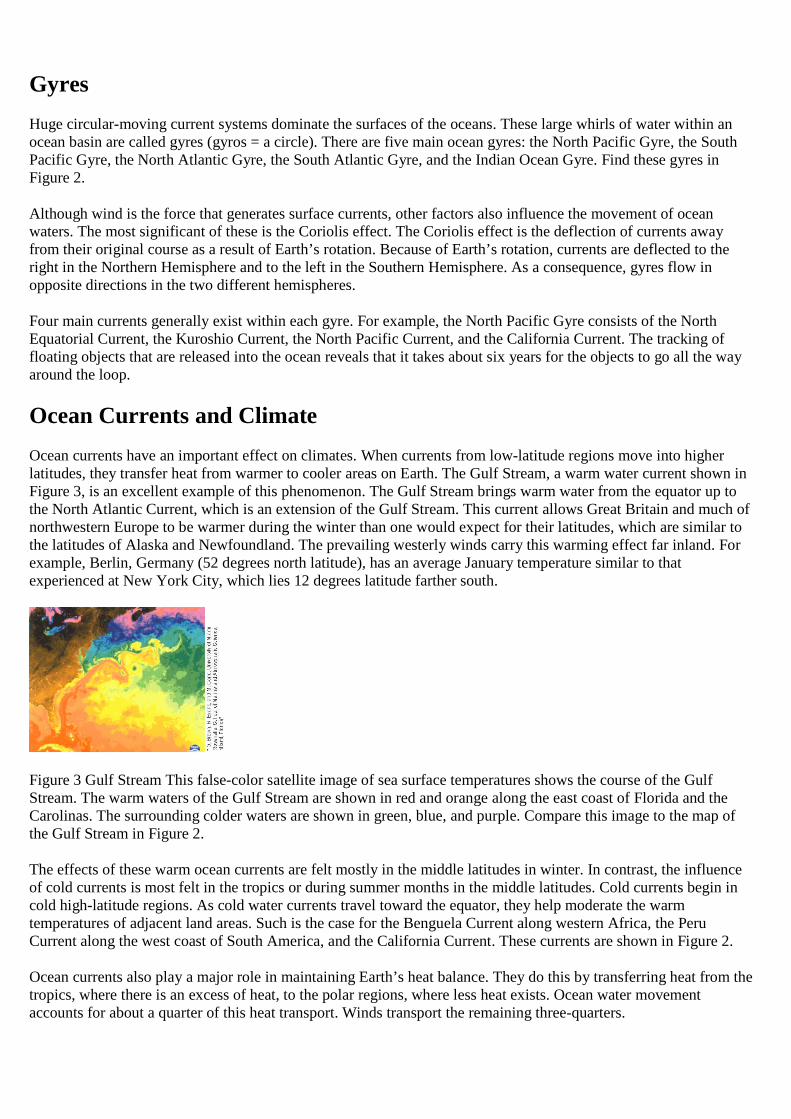
Huge circular-moving current systems dominate the surfaces of the oceans. These large whirls of water within anocean basin are called gyres (gyros = a circle). There are five main ocean gyres: the North Pacific Gyre, the SouthPacific Gyre, the North Atlantic Gyre, the South Atlantic Gyre, and the Indian Ocean Gyre. Find these gyres inFigure 2.
Although wind is the force that generates surface currents, other factors also influence the movement of oceanwaters. The most significant of these is the Coriolis effect. The Coriolis effect is the deflection of currents awayfrom their original course as a result of Earth’s rotation. Because of Earth’s rotation, currents are deflected to theright in the Northern Hemisphere and to the left in the Southern Hemisphere. As a consequence, gyres flow inopposite directions in the two different hemispheres.
Four main currents generally exist within each gyre. For example, the North Pacific Gyre consists of the NorthEquatorial Current, the Kuroshio Current, the North Pacific Current, and the California Current. The tracking offloating objects that are released into the ocean reveals that it takes about six years for the objects to go all the wayaround the loop.
Ocean Currents and Climate
Ocean currents have an important effect on climates. When currents from low-latitude regions move into higherlatitudes, they transfer heat from warmer to cooler areas on Earth. The Gulf Stream, a warm water current shown inFigure 3, is an excellent example of this phenomenon. The Gulf Stream brings warm water from the equator up tothe North Atlantic Current, which is an extension of the Gulf Stream. This current allows Great Britain and much ofnorthwestern Europe to be warmer during the winter than one would expect for their latitudes, which are similar tothe latitudes of Alaska and Newfoundland. The prevailing westerly winds carry this warming effect far inland. Forexample, Berlin, Germany (52 degrees north latitude), has an average January temperature similar to thatexperienced at New York City, which lies 12 degrees latitude farther south.
Figure 3 Gulf Stream This false-color satellite image of sea surface temperatures shows the course of the GulfStream. The warm waters of the Gulf Stream are shown in red and orange along the east coast of Florida and theCarolinas. The surrounding colder waters are shown in green, blue, and purple. Compare this image to the map ofthe Gulf Stream in Figure 2.
The effects of these warm ocean currents are felt mostly in the middle latitudes in winter. In contrast, the influenceof cold currents is most felt in the tropics or during summer months in the middle latitudes. Cold currents begin incold high-latitude regions. As cold water currents travel toward the equator, they help moderate the warmtemperatures of adjacent land areas. Such is the case for the Benguela Current along western Africa, the PeruCurrent along the west coast of South America, and the California Current. These currents are shown in Figure 2.
Ocean currents also play a major role in maintaining Earth’s heat balance. They do this by transferring heat from thetropics, where there is an excess of heat, to the polar regions, where less heat exists. Ocean water movementaccounts for about a quarter of this heat transport. Winds transport the remaining three-quarters.
Upwelling
In addition to producing surface currents, winds can also cause vertical water movements. Upwelling is the rising ofcold water from deeper layers to replace warmer surface water. Upwelling is a common wind-induced verticalmovement. One type of upwelling, called coastal upwelling, is most characteristic along the west coasts ofcontinents, most notably along California, western South America, and West Africa.
Coastal upwelling occurs in these areas when winds blow toward the equator and parallel to the coast. Coastal windscombined with the Coriolis effect cause surface water to move away from shore. As the surface layer moves awayfrom the coast, it is replaced by water that “upwells” from below the surface. This slow upward movement of waterfrom depths of 50 to 300 meters brings water that is cooler than the original surface water and results in lowersurface water temperatures near the shore.
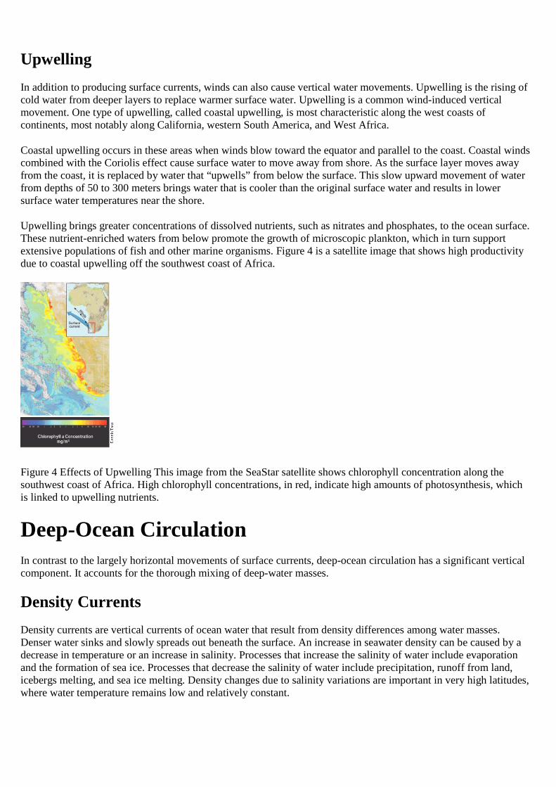
Upwelling brings greater concentrations of dissolved nutrients, such as nitrates and phosphates, to the ocean surface.These nutrient-enriched waters from below promote the growth of microscopic plankton, which in turn supportextensive populations of fish and other marine organisms. Figure 4 is a satellite image that shows high productivitydue to coastal upwelling off the southwest coast of Africa.
Figure 4 Effects of Upwelling This image from the SeaStar satellite shows chlorophyll concentration along thesouthwest coast of Africa. High chlorophyll concentrations, in red, indicate high amounts of photosynthesis, whichis linked to upwelling nutrients.
Deep-Ocean Circulation
In contrast to the largely horizontal movements of surface currents, deep-ocean circulation has a significant verticalcomponent. It accounts for the thorough mixing of deep-water masses.
Density Currents
Density currents are vertical currents of ocean water that result from density differences among water masses.Denser water sinks and slowly spreads out beneath the surface. An increase in seawater density can be caused by adecrease in temperature or an increase in salinity. Processes that increase the salinity of water include evaporationand the formation of sea ice. Processes that decrease the salinity of water include precipitation, runoff from land,icebergs melting, and sea ice melting. Density changes due to salinity variations are important in very high latitudes,where water temperature remains low and relatively constant.
High Latitudes
Most water involved in deep-ocean density currents begins in high latitudes at the surface. In these regions, surfacewater becomes cold, and its salinity increases as sea ice forms. When this water becomes dense enough, it sinks,initiating deep-ocean density currents. Once this water sinks, it is removed from the physical processes thatincreased its density in the first place. Its temperature and salinity remain largely unchanged during the time it is inthe deep ocean. Because of this, oceanographers can track the movements of density currents in the deep ocean. Byknowing the temperature, salinity, and density of a water mass, scientists are able to map the slow circulation of thewater mass through the ocean.
Near Antarctica, surface conditions create the highest density water in the world. This cold, salty water slowly sinksto the sea floor, where it moves throughout the ocean basins in slow currents. After sinking from the surface of theocean, deep waters will not reappear at the surface for an average of 500 to 2000 years.
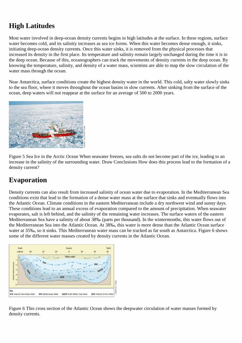
Figure 5 Sea Ice in the Arctic Ocean When seawater freezes, sea salts do not become part of the ice, leading to anincrease in the salinity of the surrounding water. Draw Conclusions How does this process lead to the formation of adensity current?
Evaporation
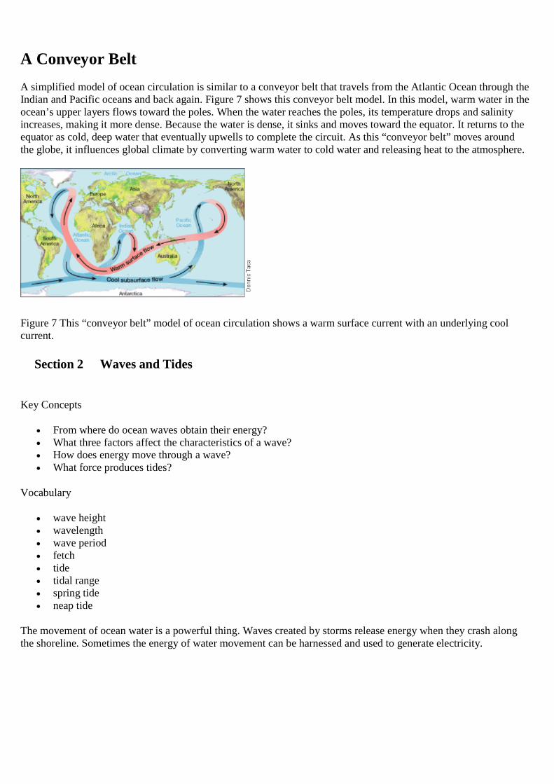
Density currents can also result from increased salinity of ocean water due to evaporation. In the Mediterranean Seaconditions exist that lead to the formation of a dense water mass at the surface that sinks and eventually flows intothe Atlantic Ocean. Climate conditions in the eastern Mediterranean include a dry northwest wind and sunny days.These conditions lead to an annual excess of evaporation compared to the amount of precipitation. When seawaterevaporates, salt is left behind, and the salinity of the remaining water increases. The surface waters of the easternMediterranean Sea have a salinity of about 38‰ (parts per thousand). In the wintermonths, this water flows out ofthe Mediterranean Sea into the Atlantic Ocean. At 38‰, this water is more dense than the Atlantic Ocean surfacewater at 35‰, so it sinks. This Mediterranean water mass can be tracked as far south as Antarctica. Figure 6 showssome of the different water masses created by density currents in the Atlantic Ocean.
Figure 6 This cross section of the Atlantic Ocean shows the deepwater circulation of water masses formed bydensity currents.
A Conveyor Belt
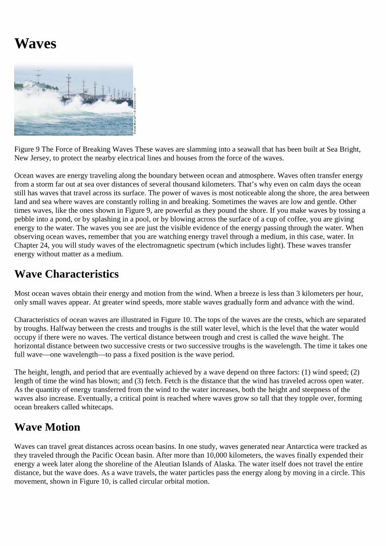
A simplified model of ocean circulation is similar to a conveyor belt that travels from the Atlantic Ocean through theIndian and Pacific oceans and back again. Figure 7 shows this conveyor belt model. In this model, warm water in theocean’s upper layers flows toward the poles. When the water reaches the poles, its temperature drops and salinityincreases, making it more dense. Because the water is dense, it sinks and moves toward the equator. It returns to theequator as cold, deep water that eventually upwells to complete the circuit. As this “conveyor belt” moves aroundthe globe, it influences global climate by converting warm water to cold water and releasing heat to the atmosphere.
Figure 7 This “conveyor belt” model of ocean circulation shows a warm surface current with an underlying coolcurrent.
Section 2 Waves and Tides
Key Concepts
From where do ocean waves obtain their energy? What three factors affect the characteristics of a wave? How does energy move through a wave? What force produces tides?
Vocabulary
wave height wavelength wave period fetch tide tidal range spring tide neap tide
The movement of ocean water is a powerful thing. Waves created by storms release energy when they crash alongthe shoreline. Sometimes the energy of water movement can be harnessed and used to generate electricity.
Waves
Figure 9 The Force of Breaking Waves These waves are slamming into a seawall that has been built at Sea Bright,New Jersey, to protect the nearby electrical lines and houses from the force of the waves.
Ocean waves are energy traveling along the boundary between ocean and atmosphere. Waves often transfer energyfrom a storm far out at sea over distances of several thousand kilometers. That’s why even on calm days the oceanstill has waves that travel across its surface. The power of waves is most noticeable along the shore, the area betweenland and sea where waves are constantly rolling in and breaking. Sometimes the waves are low and gentle. Othertimes waves, like the ones shown in Figure 9, are powerful as they pound the shore. If you make waves by tossing apebble into a pond, or by splashing in a pool, or by blowing across the surface of a cup of coffee, you are givingenergy to the water. The waves you see are just the visible evidence of the energy passing through the water. Whenobserving ocean waves, remember that you are watching energy travel through a medium, in this case, water. InChapter 24, you will study waves of the electromagnetic spectrum (which includes light). These waves transferenergy without matter as a medium.
Wave Characteristics
Most ocean waves obtain their energy and motion from the wind. When a breeze is less than 3 kilometers per hour,only small waves appear. At greater wind speeds, more stable waves gradually form and advance with the wind.
Characteristics of ocean waves are illustrated in Figure 10. The tops of the waves are the crests, which are separatedby troughs. Halfway between the crests and troughs is the still water level, which is the level that the water wouldoccupy if there were no waves. The vertical distance between trough and crest is called the wave height. Thehorizontal distance between two successive crests or two successive troughs is the wavelength. The time it takes onefull wave—one wavelength—to pass a fixed position is the wave period.
The height, length, and period that are eventually achieved by a wave depend on three factors: (1) wind speed; (2)length of time the wind has blown; and (3) fetch. Fetch is the distance that the wind has traveled across open water.As the quantity of energy transferred from the wind to the water increases, both the height and steepness of thewaves also increase. Eventually, a critical point is reached where waves grow so tall that they topple over, formingocean breakers called whitecaps.
Wave Motion
Waves can travel great distances across ocean basins. In one study, waves generated near Antarctica were tracked asthey traveled through the Pacific Ocean basin. After more than 10,000 kilometers, the waves finally expended theirenergy a week later along the shoreline of the Aleutian Islands of Alaska. The water itself does not travel the entiredistance, but the wave does. As a wave travels, the water particles pass the energy along by moving in a circle. Thismovement, shown in Figure 10, is called circular orbital motion.
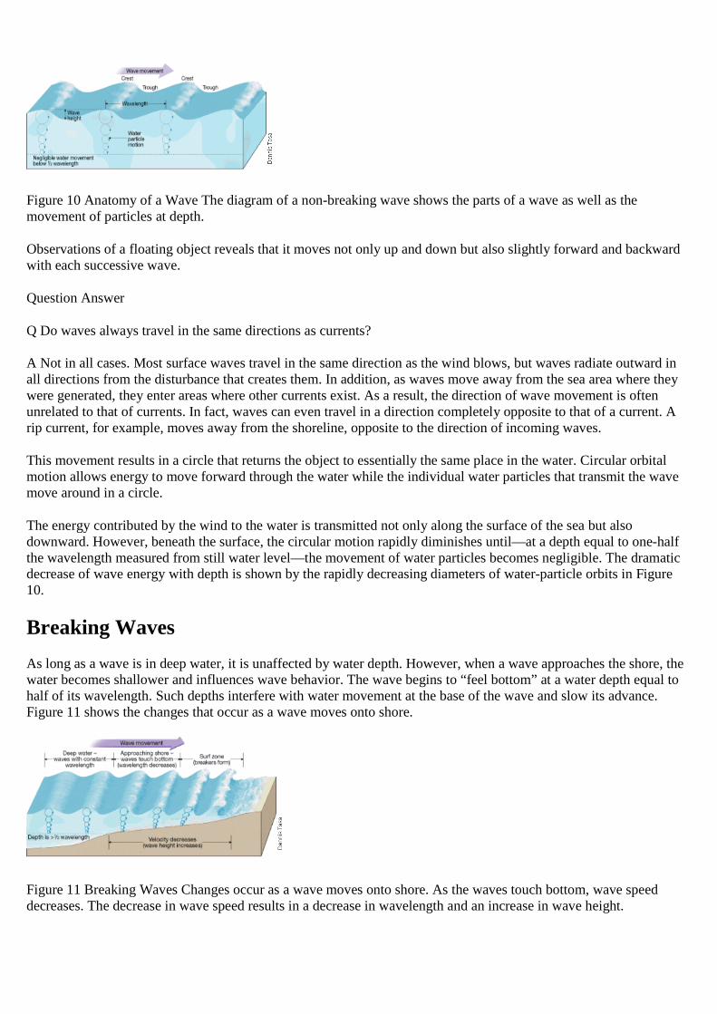
Figure 10 Anatomy of a Wave The diagram of a non-breaking wave shows the parts of a wave as well as themovement of particles at depth.
Observations of a floating object reveals that it moves not only up and down but also slightly forward and backwardwith each successive wave.
Question Answer
Q Do waves always travel in the same directions as currents?
A Not in all cases. Most surface waves travel in the same direction as the wind blows, but waves radiate outward inall directions from the disturbance that creates them. In addition, as waves move away from the sea area where theywere generated, they enter areas where other currents exist. As a result, the direction of wave movement is oftenunrelated to that of currents. In fact, waves can even travel in a direction completely opposite to that of a current. Arip current, for example, moves away from the shoreline, opposite to the direction of incoming waves.
This movement results in a circle that returns the object to essentially the same place in the water. Circular orbitalmotion allows energy to move forward through the water while the individual water particles that transmit the wavemove around in a circle.
The energy contributed by the wind to the water is transmitted not only along the surface of the sea but alsodownward. However, beneath the surface, the circular motion rapidly diminishes until—at a depth equal to one-halfthe wavelength measured from still water level—the movement of water particles becomes negligible. The dramaticdecrease of wave energy with depth is shown by the rapidly decreasing diameters of water-particle orbits in Figure10.
Breaking Waves
As long as a wave is in deep water, it is unaffected by water depth. However, when a wave approaches the shore, thewater becomes shallower and influences wave behavior. The wave begins to “feel bottom” at a water depth equal tohalf of its wavelength. Such depths interfere with water movement at the base of the wave and slow its advance.Figure 11 shows the changes that occur as a wave moves onto shore.
Figure 11 Breaking Waves Changes occur as a wave moves onto shore. As the waves touch bottom, wave speeddecreases. The decrease in wave speed results in a decrease in wavelength and an increase in wave height.
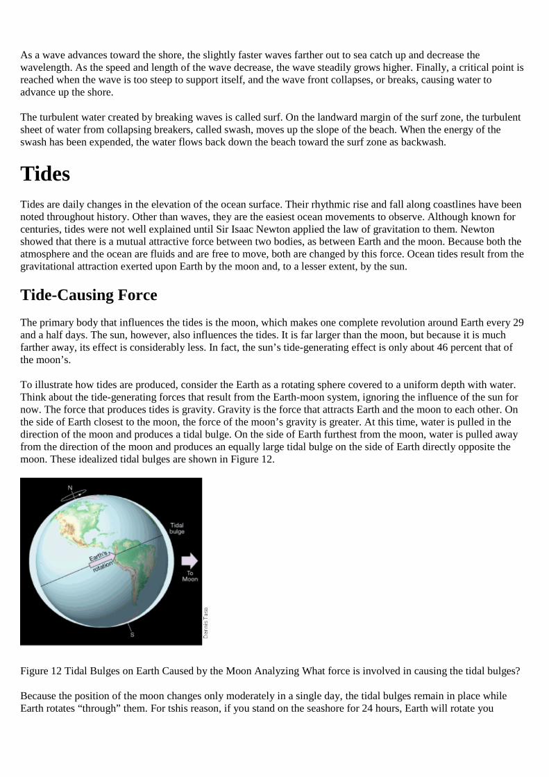
As a wave advances toward the shore, the slightly faster waves farther out to sea catch up and decrease thewavelength. As the speed and length of the wave decrease, the wave steadily grows higher. Finally, a critical point isreached when the wave is too steep to support itself, and the wave front collapses, or breaks, causing water toadvance up the shore.
The turbulent water created by breaking waves is called surf. On the landward margin of the surf zone, the turbulentsheet of water from collapsing breakers, called swash, moves up the slope of the beach. When the energy of theswash has been expended, the water flows back down the beach toward the surf zone as backwash.
Tides
Tides are daily changes in the elevation of the ocean surface. Their rhythmic rise and fall along coastlines have beennoted throughout history. Other than waves, they are the easiest ocean movements to observe. Although known forcenturies, tides were not well explained until Sir Isaac Newton applied the law of gravitation to them. Newtonshowed that there is a mutual attractive force between two bodies, as between Earth and the moon. Because both theatmosphere and the ocean are fluids and are free to move, both are changed by this force. Ocean tides result from thegravitational attraction exerted upon Earth by the moon and, to a lesser extent, by the sun.
Tide-Causing Force
The primary body that influences the tides is the moon, which makes one complete revolution around Earth every 29and a half days. The sun, however, also influences the tides. It is far larger than the moon, but because it is muchfarther away, its effect is considerably less. In fact, the sun’s tide-generating effect is only about 46 percent that ofthe moon’s.
To illustrate how tides are produced, consider the Earth as a rotating sphere covered to a uniform depth with water.Think about the tide-generating forces that result from the Earth-moon system, ignoring the influence of the sun fornow. The force that produces tides is gravity. Gravity is the force that attracts Earth and the moon to each other. Onthe side of Earth closest to the moon, the force of the moon’s gravity is greater. At this time, water is pulled in thedirection of the moon and produces a tidal bulge. On the side of Earth furthest from the moon, water is pulled awayfrom the direction of the moon and produces an equally large tidal bulge on the side of Earth directly opposite themoon. These idealized tidal bulges are shown in Figure 12.
Figure 12 Tidal Bulges on Earth Caused by the Moon Analyzing What force is involved in causing the tidal bulges?
Because the position of the moon changes only moderately in a single day, the tidal bulges remain in place whileEarth rotates “through” them. For tshis reason, if you stand on the seashore for 24 hours, Earth will rotate you
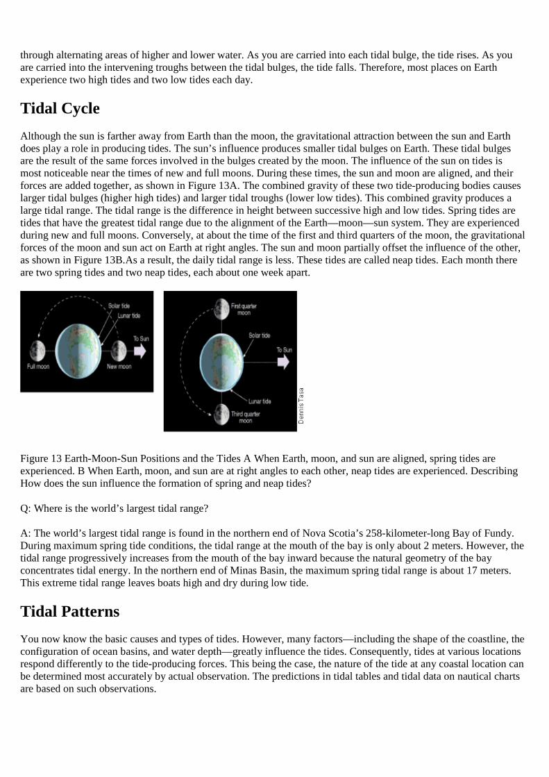
through alternating areas of higher and lower water. As you are carried into each tidal bulge, the tide rises. As youare carried into the intervening troughs between the tidal bulges, the tide falls. Therefore, most places on Earthexperience two high tides and two low tides each day.
Tidal Cycle
Although the sun is farther away from Earth than the moon, the gravitational attraction between the sun and Earthdoes play a role in producing tides. The sun’s influence produces smaller tidal bulges on Earth. These tidal bulgesare the result of the same forces involved in the bulges created by the moon. The influence of the sun on tides ismost noticeable near the times of new and full moons. During these times, the sun and moon are aligned, and theirforces are added together, as shown in Figure 13A. The combined gravity of these two tide-producing bodies causeslarger tidal bulges (higher high tides) and larger tidal troughs (lower low tides). This combined gravity produces alarge tidal range. The tidal range is the difference in height between successive high and low tides. Spring tides aretides that have the greatest tidal range due to the alignment of the Earth—moon—sun system. They are experiencedduring new and full moons. Conversely, at about the time of the first and third quarters of the moon, the gravitationalforces of the moon and sun act on Earth at right angles. The sun and moon partially offset the influence of the other,as shown in Figure 13B.As a result, the daily tidal range is less. These tides are called neap tides. Each month thereare two spring tides and two neap tides, each about one week apart.
Figure 13 Earth-Moon-Sun Positions and the Tides A When Earth, moon, and sun are aligned, spring tides areexperienced. B When Earth, moon, and sun are at right angles to each other, neap tides are experienced. DescribingHow does the sun influence the formation of spring and neap tides?
Q: Where is the world’s largest tidal range?
A: The world’s largest tidal range is found in the northern end of Nova Scotia’s 258-kilometer-long Bay of Fundy.During maximum spring tide conditions, the tidal range at the mouth of the bay is only about 2 meters. However, thetidal range progressively increases from the mouth of the bay inward because the natural geometry of the bayconcentrates tidal energy. In the northern end of Minas Basin, the maximum spring tidal range is about 17 meters.This extreme tidal range leaves boats high and dry during low tide.
Tidal Patterns
You now know the basic causes and types of tides. However, many factors—including the shape of the coastline, theconfiguration of ocean basins, and water depth—greatly influence the tides. Consequently, tides at various locationsrespond differently to the tide-producing forces. This being the case, the nature of the tide at any coastal location canbe determined most accurately by actual observation. The predictions in tidal tables and tidal data on nautical chartsare based on such observations.
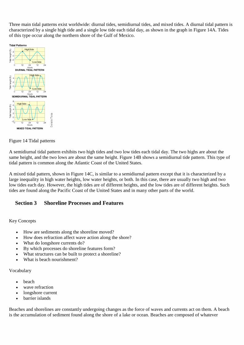
Three main tidal patterns exist worldwide: diurnal tides, semidiurnal tides, and mixed tides. A diurnal tidal pattern ischaracterized by a single high tide and a single low tide each tidal day, as shown in the graph in Figure 14A. Tidesof this type occur along the northern shore of the Gulf of Mexico.
Figure 14 Tidal patterns
A semidiurnal tidal pattern exhibits two high tides and two low tides each tidal day. The two highs are about thesame height, and the two lows are about the same height. Figure 14B shows a semidiurnal tide pattern. This type oftidal pattern is common along the Atlantic Coast of the United States.
A mixed tidal pattern, shown in Figure 14C, is similar to a semidiurnal pattern except that it is characterized by alarge inequality in high water heights, low water heights, or both. In this case, there are usually two high and twolow tides each day. However, the high tides are of different heights, and the low tides are of different heights. Suchtides are found along the Pacific Coast of the United States and in many other parts of the world.
Section 3 Shoreline Processes and Features
Key Concepts
How are sediments along the shoreline moved? How does refraction affect wave action along the shore? What do longshore currents do? By which processes do shoreline features form? What structures can be built to protect a shoreline? What is beach nourishment?
Vocabulary
beach wave refraction longshore current barrier islands
Beaches and shorelines are constantly undergoing changes as the force of waves and currents act on them. A beachis the accumulation of sediment found along the shore of a lake or ocean. Beaches are composed of whatever
sediment is locally available. They may be made of mineral particles from the erosion of beach cliffs or nearbycoastal mountains. This sediment may be relatively coarse in texture. Some beaches have a significant biologicalcomponent. For example, most beaches in southern Florida are composed of shell fragments and the remains oforganisms that live in coastal waters. Regardless of the composition, the sediment that makes up the beach does notstay in one place. The waves that crash along the shoreline are constantly moving it. Beaches can be thought of asmaterial in transit along the shoreline.
Forces Acting on the ShorelineWaves along the shoreline are constantly eroding, transporting, and depositing sediment. Many types of shorelinefeatures can result from this activity.
Wave Impact
During calm weather, wave action is minimal. During storms, however, waves are capable of causing much erosion.The impact of large, high-energy waves against the shore can be awesome in its violence. Each breaking wave mayhurl thousands of tons of water against the land, sometimes causing the ground to tremble.
It is no wonder that cracks and crevices are quickly opened in cliffs, coastal structures, and anything else that issubjected to these enormous impacts. Water is forced into every opening, causing air in the cracks to become highlycompressed by the thrust of crashing waves. When the wave subsides, the air expands rapidly. This expanding airdislodges rock fragments and enlarges and extends preexisting fractures.
Abrasion
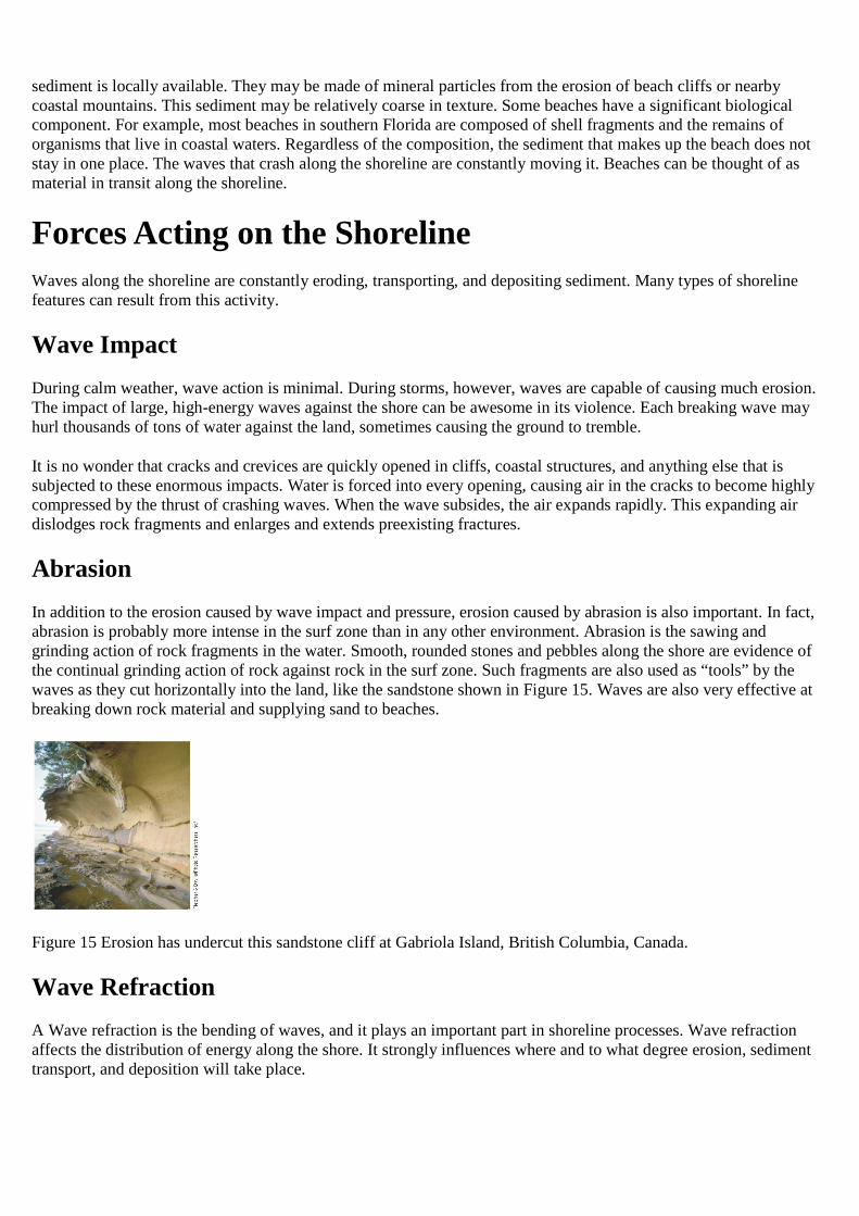
In addition to the erosion caused by wave impact and pressure, erosion caused by abrasion is also important. In fact,abrasion is probably more intense in the surf zone than in any other environment. Abrasion is the sawing andgrinding action of rock fragments in the water. Smooth, rounded stones and pebbles along the shore are evidence ofthe continual grinding action of rock against rock in the surf zone. Such fragments are also used as “tools” by thewaves as they cut horizontally into the land, like the sandstone shown in Figure 15. Waves are also very effective atbreaking down rock material and supplying sand to beaches.
Figure 15 Erosion has undercut this sandstone cliff at Gabriola Island, British Columbia, Canada.
Wave Refraction
A Wave refraction is the bending of waves, and it plays an important part in shoreline processes. Wave refractionaffects the distribution of energy along the shore. It strongly influences where and to what degree erosion, sedimenttransport, and deposition will take place.
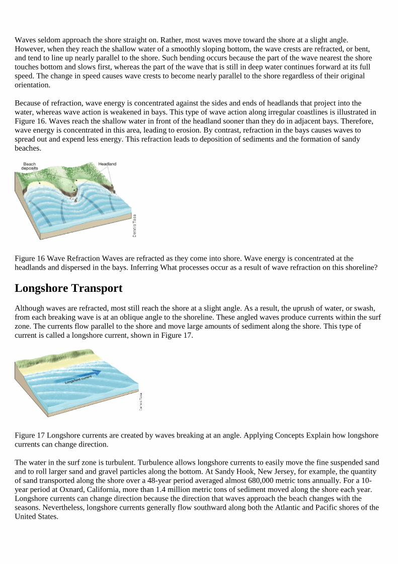
Waves seldom approach the shore straight on. Rather, most waves move toward the shore at a slight angle.However, when they reach the shallow water of a smoothly sloping bottom, the wave crests are refracted, or bent,and tend to line up nearly parallel to the shore. Such bending occurs because the part of the wave nearest the shoretouches bottom and slows first, whereas the part of the wave that is still in deep water continues forward at its fullspeed. The change in speed causes wave crests to become nearly parallel to the shore regardless of their originalorientation.
Because of refraction, wave energy is concentrated against the sides and ends of headlands that project into thewater, whereas wave action is weakened in bays. This type of wave action along irregular coastlines is illustrated inFigure 16. Waves reach the shallow water in front of the headland sooner than they do in adjacent bays. Therefore,wave energy is concentrated in this area, leading to erosion. By contrast, refraction in the bays causes waves tospread out and expend less energy. This refraction leads to deposition of sediments and the formation of sandybeaches.
Figure 16 Wave Refraction Waves are refracted as they come into shore. Wave energy is concentrated at theheadlands and dispersed in the bays. Inferring What processes occur as a result of wave refraction on this shoreline?
Longshore Transport
Although waves are refracted, most still reach the shore at a slight angle. As a result, the uprush of water, or swash,from each breaking wave is at an oblique angle to the shoreline. These angled waves produce currents within the surfzone. The currents flow parallel to the shore and move large amounts of sediment along the shore. This type ofcurrent is called a longshore current, shown in Figure 17.
Figure 17 Longshore currents are created by waves breaking at an angle. Applying Concepts Explain how longshorecurrents can change direction.
The water in the surf zone is turbulent. Turbulence allows longshore currents to easily move the fine suspended sandand to roll larger sand and gravel particles along the bottom. At Sandy Hook, New Jersey, for example, the quantityof sand transported along the shore over a 48-year period averaged almost 680,000 metric tons annually. For a 10-year period at Oxnard, California, more than 1.4 million metric tons of sediment moved along the shore each year.Longshore currents can change direction because the direction that waves approach the beach changes with theseasons. Nevertheless, longshore currents generally flow southward along both the Atlantic and Pacific shores of theUnited States.
Erosional Features
A fascinating assortment of shoreline features can be observed along the world’s coastal regions. These shorelinefeatures vary depending on the type of rocks exposed along the shore, the intensity of waves, the nature of coastalcurrents, and whether the coast is stable, sinking, or rising. Shoreline features that originate primarily from the workof erosion are called erosional features. Sediment that is transported along the shore and deposited in areas whereenergy is low produce depositional features.
Many coastal landforms owe their origin to erosional processes. Such erosional features are common along therugged and irregular New England coast and along the steep shorelines of the West Coast of the United States.
Wave-Cut Cliffs and Platforms
Wave-cut cliffs, like the one shown in Figure 20C, result from the cutting action of the surf against the base ofcoastal land. As erosion progresses, rocks that overhang the notch at the base of the cliff crumble into the surf, andthe cliff retreats. A relatively flat, benchlike surface, called a wave-cut platform, is left behind by the receding cliff.The platform broadens as the wave attack continues. Some debris produced by the breaking waves remains along thewater’s edge as sediment on the beach. The rest of the sediment is transported farther seaward.
Sea Arches and Sea Stacks
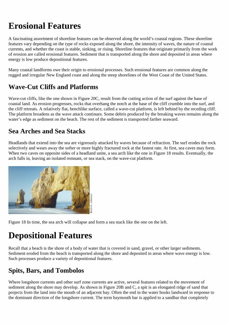
Headlands that extend into the sea are vigorously attacked by waves because of refraction. The surf erodes the rockselectively and wears away the softer or more highly fractured rock at the fastest rate. At first, sea caves may form.When two caves on opposite sides of a headland unite, a sea arch like the one in Figure 18 results. Eventually, thearch falls in, leaving an isolated remnant, or sea stack, on the wave-cut platform.
Figure 18 In time, the sea arch will collapse and form a sea stack like the one on the left.
Depositional Features
Recall that a beach is the shore of a body of water that is covered in sand, gravel, or other larger sediments.Sediment eroded from the beach is transported along the shore and deposited in areas where wave energy is low.Such processes produce a variety of depositional features.
Spits, Bars, and Tombolos
Where longshore currents and other surf zone currents are active, several features related to the movement ofsediment along the shore may develop. As shown in Figure 20B and C, a spit is an elongated ridge of sand thatprojects from the land into the mouth of an adjacent bay. Often the end in the water hooks landward in response tothe dominant direction of the longshore current. The term baymouth bar is applied to a sandbar that completely
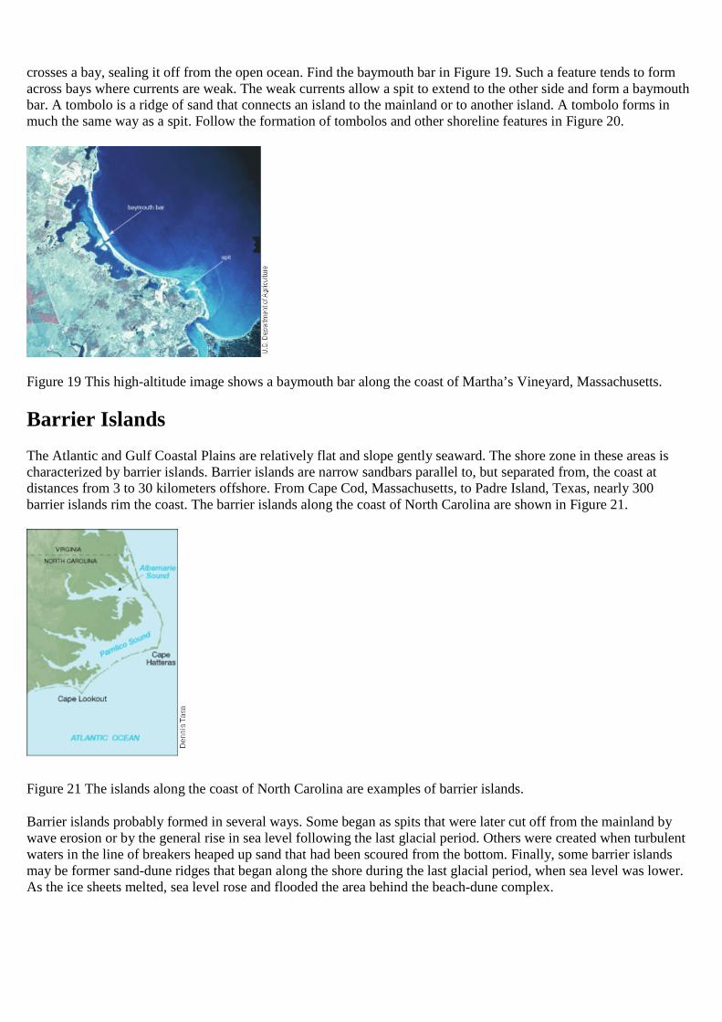
crosses a bay, sealing it off from the open ocean. Find the baymouth bar in Figure 19. Such a feature tends to formacross bays where currents are weak. The weak currents allow a spit to extend to the other side and form a baymouthbar. A tombolo is a ridge of sand that connects an island to the mainland or to another island. A tombolo forms inmuch the same way as a spit. Follow the formation of tombolos and other shoreline features in Figure 20.
Figure 19 This high-altitude image shows a baymouth bar along the coast of Martha’s Vineyard, Massachusetts.
Barrier Islands
The Atlantic and Gulf Coastal Plains are relatively flat and slope gently seaward. The shore zone in these areas ischaracterized by barrier islands. Barrier islands are narrow sandbars parallel to, but separated from, the coast atdistances from 3 to 30 kilometers offshore. From Cape Cod, Massachusetts, to Padre Island, Texas, nearly 300barrier islands rim the coast. The barrier islands along the coast of North Carolina are shown in Figure 21.
Figure 21 The islands along the coast of North Carolina are examples of barrier islands.
Barrier islands probably formed in several ways. Some began as spits that were later cut off from the mainland bywave erosion or by the general rise in sea level following the last glacial period. Others were created when turbulentwaters in the line of breakers heaped up sand that had been scoured from the bottom. Finally, some barrier islandsmay be former sand-dune ridges that began along the shore during the last glacial period, when sea level was lower.As the ice sheets melted, sea level rose and flooded the area behind the beach-dune complex.
Stabilizing the Shore
Shorelines are among Earth’s most dynamic places. They change rapidly in response to natural forces. Storms arecapable of eroding beaches and cliffs at rates that far exceed the long-term average erosion. Such bursts ofaccelerated erosion not only affect the natural evolution of a coast but can also have a profound impact on peoplewho reside in the coastal zone. Erosion along the coast causes significant property damage. Huge sums of money arespent annually not only to repair damage but also to prevent or control erosion.
Protective Structures
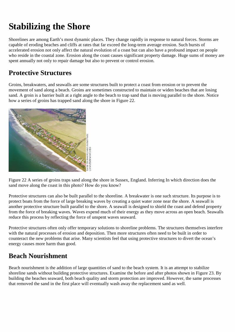
Groins, breakwaters, and seawalls are some structures built to protect a coast from erosion or to prevent themovement of sand along a beach. Groins are sometimes constructed to maintain or widen beaches that are losingsand. A groin is a barrier built at a right angle to the beach to trap sand that is moving parallel to the shore. Noticehow a series of groins has trapped sand along the shore in Figure 22.
Figure 22 A series of groins traps sand along the shore in Sussex, England. Inferring In which direction does thesand move along the coast in this photo? How do you know?
Protective structures can also be built parallel to the shoreline. A breakwater is one such structure. Its purpose is toprotect boats from the force of large breaking waves by creating a quiet water zone near the shore. A seawall isanother protective structure built parallel to the shore. A seawall is designed to shield the coast and defend propertyfrom the force of breaking waves. Waves expend much of their energy as they move across an open beach. Seawallsreduce this process by reflecting the force of unspent waves seaward.
Protective structures often only offer temporary solutions to shoreline problems. The structures themselves interferewith the natural processes of erosion and deposition. Then more structures often need to be built in order tocounteract the new problems that arise. Many scientists feel that using protective structures to divert the ocean’senergy causes more harm than good.
Beach Nourishment
Beach nourishment is the addition of large quantities of sand to the beach system. It is an attempt to stabilizeshoreline sands without building protective structures. Examine the before and after photos shown in Figure 23. Bybuilding the beaches seaward, both beach quality and storm protection are improved. However, the same processesthat removed the sand in the first place will eventually wash away the replacement sand as well.
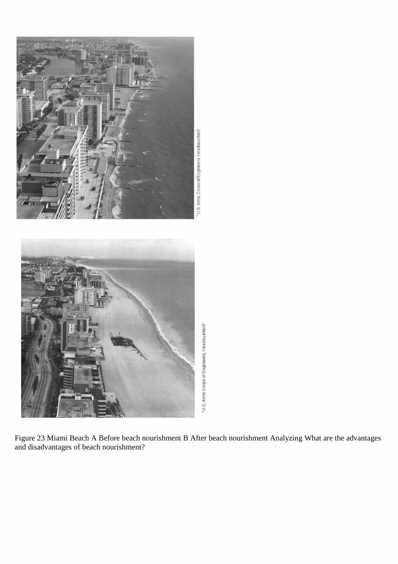
Figure 23 Miami Beach A Before beach nourishment B After beach nourishment Analyzing What are the advantagesand disadvantages of beach nourishment?