Embed Size (px)
Citation preview

Section 2 Landscape Types
2.1 Landscape types are distinct types of landscape that are relatively homogeneous in character. They are generic in nature in that they may occur in different areas, but wherever they occur they share broadly similar combinations of geology, topography, drainage patterns, vegetation, historical land use and settlement pattern.
Ranworth Broad Broads Authority 45

The Broads "A breathing space for the cure of souls" Landscape types
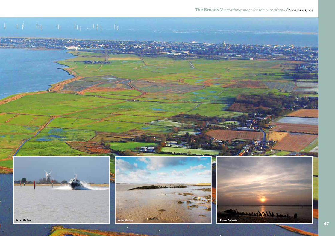
1 Tidal estuary
Breydon Water is the only example of the tidal estuary type to be found within the Broads area. Therefore all relevant information has been included within the Yare - Breydon Water landscape character area on page 170.
Mike Page46
The Broads "A breathing space for the cure of souls" Landscape types
Julian Claxton Julian Claxton Broads Authority
47

The Broads "A breathing space for the cure of souls" Landscape types
2 Rivers, ronds and floodbanksThree principle rivers, the Yare, Bure and Waveney and their tributaries, the Wensum, Chet, Ant and Thurne plus the canal at Dilham and the Cut at Haddiscoe create the physical link to all parts of the Broads and provide corridors for movement for people, plants and animals.
These rivers form part of a larger network of rivers and streams extending far beyond the Broads forming the Broadland Rivers Catchment. This catchment which includes two thirds of Norfolk and part of north Suffolk, funnels the rain falling within its area eastwards, either above or below ground, ending up in the rivers flowing through the Broads.
Its distinctive landscape characteristics are:lThe rivers lie at or below sea level;
lThe rivers and their valleys become wider the closer they get to the coast, are slow flowing and for the most part subject to the tides;
lThe nearer to the coast the river becomes saltier;
lDifferent plants and animals are associated with the differing water conditions (salty/freshwater/muddy/clear);
lThe rivers provide 200 kilometres of navigable water waterways which are popular for recreation attracting many different types of boats;
lThe rivers provide an important national fishery resource;
lOver centuries the sections of rivers that lie closer to the coast have had flood banks constructed on the edges of the river to protect the land beyond;
lThe flood banks become taller the closer the river gets to the coast;
lThe flood banks can limit views from the river to the landscape beyond especially at low tide;
lThe sections of the rivers within the estuarine marshes can have wide ronds on which reeds grow;
lCarr woodland or fen enclose the stretches of the river in the upper reaches where there are peat soils;
lWhere the river flows through grazing marsh there are “big skies” whilst there is a more enclosed feel and limited views through sections of river flowing through carr woodland and fen;
lWhere there is settlement, the river bank edges are often retained by quay heading (steel and wood) which can give more urban feel to the river;
lThe modifications to the river systems and banks within the settlements of Gt. Yarmouth and Norwich hint at their past industrial /transportation links and importance;
lDifferent types of settlement (see Settled Broads type) can influence the character of the river.
The hard edges to the river in towns and villages contrast dramatically with well vegetated river edges in the countryside.
David Medcalf - geograph.org.uk
Pierre Terre - geograph.org.uk48

The Broads "A breathing space for the cure of souls" Landscape types
The rivers flow in a west-east direction ultimately joining up at Great Yarmouth where they enter the North Sea. The majority of the river system within the Broads area is subject to the twice daily tides.
The river systems downstream nearer the coast (also called the lower reaches) are subject to far greater changes in the water levels in the rivers than those upstream which are inland (also called the upper reaches). The water of those sections of rivers nearer the coast are also saltier (brackish). The brackishness of the water results in different types of plants and animals (fish especially) to those in freshwater areas upstream. The quality of the water can differ throughout the Broads which will influence the type and amount of vegetation and animals within it.
On extremely high tides or in flood conditions salt water can be “pushed or up” the river system into the freshwater areas. This can have a catastrophic effect on the fresh water fish populations killing many. However, fish can detect these changes and they actively seek out fresher water. The Environment Agency has provided a number of refuges for them.
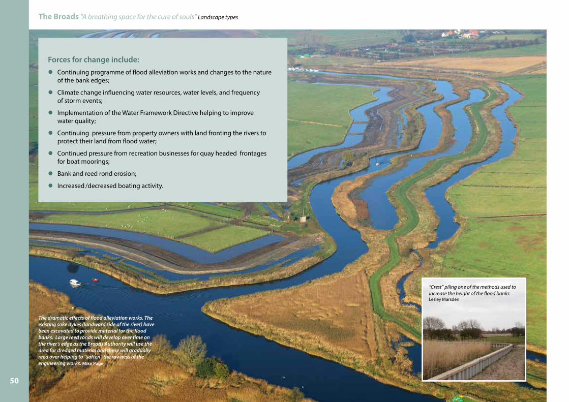
An Environment Agency project starting in 2001 and to last for 20 years has seen flood banks restored to the height they were in 1995. To do this material was often locally sourced by increasing the width and sometimes the depth of the adjacent soke dyke. Generally one of three options were chosen for the re-design of the bank. The flood bank could be strengthened on its existing alignment (taller wider); it could be “rolled back” meaning that it was made taller wider but moved back from the
river’s edge or it could be “setback”. The last two options potentially allowed the rond widths to be increased. Ronds are the areas of low lying land which lies between the river and the floodbank. They are important as not only do they provide space for river water, the reed which becomes established on them acts to protect the flood bank from erosion from waves caused by wind and boats thereby providing a more sustainable solution to flood protection. Reed (Phragmites australis) tends to be the dominant plant species that becomes established on the ronds. Its height, feathery nature and changing seasonal colour add both visual interest and provides habitat for Broads wildlife.
Only where there was no other option or where it was found beneficial to have moorings, has the Environment Agency had to re-pile sections of bank.
The character of the of the different stretches of river are greatly influenced by;
lThe proximity of the river valley sides which can provide a sense of enclosure within the narrower valleys of the upper reaches or, as in the lower reaches, be so far away that the view from the river are expansive and the famed “big skies” are dominant;
lThe proximity of settlement which can both detract from the peace and quiet normally associated with the Broads but can also add interest and variety;
lThe types of vegetation is generally dictated by the soils. The estuarine marshland areas of silt and clay soils supporting marshland vegetation and reeded ronds and the peat soils supporting fen and carr woodland;
lThe past use of the river for trade and transport and the infrastructure that supported this activity.
Good water quality encourages more plant life providing better habitat for plants and animals.
Steve Daniels - geograph.org.uk
Simon Finlay
Simon Finlay
49
The Broads "A breathing space for the cure of souls" Landscape types
Forces for change include:l Continuing programme of flood alleviation works and changes to the nature of the bank edges;
lClimate change influencing water resources, water levels, and frequency of storm events;
lImplementation of the Water Framework Directive helping to improve water quality;
lContinuing pressure from property owners with land fronting the rivers to protect their land from flood water;
lContinued pressure from recreation businesses for quay headed frontages for boat moorings;
lBank and reed rond erosion;
lIncreased /decreased boating activity.
The dramatic effects of flood alleviation works. The existing soke dykes (landward side of the river) have been excavated to provide material for the flood banks. Large reed ronds will develop over time on the river’s edge as the Broads Authority will use the area for dredged material and these will gradually reed over helping to “soften” the rawness of the engineering works. Mike Page
“Crest” piling one of the methods used to increase the height of the flood banks.Lesley Marsden
50

The Broads "A breathing space for the cure of souls" Landscape types
3 Coastal dunesAlong the low-lying coastal strip between Eccles- on- Sea and Winterton-on-Sea is the only area in the Broads (character area 30) where the Coastal Dune type can be found. However the Broads has a strong connection to the coast as it influences the local climate and the saline waters can affect water quality within the freshwater environment of the marshes especially during surge tides and storm events.
Its distinctive landscape characteristics are:lThere are three internationally important dune habitats (embryonic shifting dunes, dune slacks and coastal dune heaths);
l They are dynamic in nature and vulnerable to fast change as a result of storm damage and damage by people;
l The dune systems form a physical and visual barrier between the sea (with its saline characteristics) and the freshwater marshland environment of the Broads hinterland;
l Much of the area is heavily designated for nature conservation;
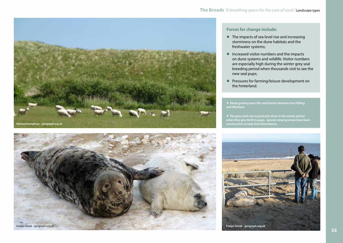
l The area generally tends to feel remote and tranquil. This characteristic is impacted upon by the vast number of visitors during the seal breeding period in winter;
l Flood defence and access structures.
The dunes and associated beach systems provide a valuable natural defence that along with others along the coast helps to shield the large area of low-lying hinterland from coastal flooding during storms. They are also a valuable habitat adding to the diversity in the Broads.The unusual dunes at Winterton are more similar to those in the Baltic than other sites on the Norfolk coast, as acid-loving plants grow here. Within the wet slacks of the dunes, natterjack toads breed in shallow pools, whilst nightjar, barn owl, skylark and stonechat breed nearby.
Down on the beach, harbour seal and grey seal can be seen swimming and basking. The grey seal breeding colony is monitored with the help of volunteers, who also work to ensure visitors do not disturb them. On the open shingle beach little terns build their nests.
The areas importance in habitat, species and landscape terms is reflected in the number of nature conservation designations and that it is also part of an Area of Outstanding Natural Beauty.
The dune systems stand many metres above the surrounding land. They form an effective visual screen between two very different landscapes.
The dune systems can be easily damaged as a result of foot traffic. This makes them more vulnerable to erosion.
Mike Flaherty - geograph.org.uk Evelyn Simak - geograph.org.uk
Evelyn Simak - geograph.org.uk
Evelyn Simak - geograph.org.uk
51

The Broads "A breathing space for the cure of souls" Landscape types
Engineered structures in the form of access routes (which can be defended in times of storm events), concrete flood walls and groynes (to help reduce longshore drift) are not uncommon features in this landscape type area.Evelyn Simak - geograph.org.uk Hugh Venables - geograph.org.uk
52
The Broads "A breathing space for the cure of souls" Landscape types
Forces for change include:
lThe impacts of sea level rise and increasing storminess on the dune habitats and the freshwater systems;
l Increased visitor numbers and the impacts on dune systems and wildlife. Visitor numbers are especially high during the winter grey seal breeding period when thousands visit to see the new seal pups;
l Pressures for farming/leisure development on the hinterland.
The grey seals are a particular draw in the winter period when they give birth to pups. Special viewing areas have been construction to help limit disturbance.
Sheep grazing near the sand dunes between Sea Palling and Waxham.
Richard Humphrey - geograph.org.uk
Evelyn Simak - geograph.org.uk Evelyn Simak - geograph.org.uk
53

4 Estuarine marshlandThe Broads "A breathing space for the cure of souls" Landscape types
This landscape type, which covers up to 40% of the Broads, is so called as the marsh occupies the extent of the former great estuary. See the video The Great-Estuary-Story.http://www.broads.co.uk/videos/the-great-estuary-story/
The marshland landscape evokes mixed reactions within people. Some people regard it as a place to escape the stresses and strains of everyday life, whilst others consider the isolated nature of the marshes as desolate, lonely places.
Whatever people’s perceptions, the known history of the marshland and its people is fascinating. But there are many mysteries to unravel about how people have used this area over the centuries.
It is a landscape at risk as its use as traditional grazing marsh with its wildlife friendly water management systems is subject to changing economic drivers and stretched farming subsidy systems. The drainage mills, an integral part of this landscape, are a nationally and perhaps internationally important group but no longer have an economic function which has lead to their neglect.
Its distinctive landscape characteristics are:lVery low lying flat land which is all at or below sea level;
l Silty clay soils on the surface with underlying peat deposits;
l The marshes are divided into “fields” by drainage dykes and ditches;
lExtensive cattle grazing marshes;
l Drainage mills – in various states of repair;
l Arable reversion concentrated in certain areas;
l Little tree or shrub vegetation except at the boundary with the valley sides, where carr woodland may exist and adjacent to the isolated buildings on the marshes;
l Expansive views often to locations outside the Broads area and “big skies”;
l Isolated farmsteads;
l A sense of isolation in the broader valley reaches;
l Flood banks along the river valleys with their associated soke dykes, foldings and reed ronds;
l Internal drainage board structures such as pump houses, weed clearance devices and outfalls;
l An abundance of wildlife making use of both land and water.
Grazing marsh, drainage mills, dykes and big skies –all key landscape elements of the estuarine marshland type.Ashley Dace - geograph.org.uk
54

Silts and clay deposits
Middle peat
Lower peat
Lower clay
Soil strata
Alder carrwoodland
on peat
River
Floodbank
Pumping waterThe drainage mills
used to do the work that electric pumps do today,
lifting the water from the grazing marshes
into the river
RondReeds grow helping to protect the �ood bank
Water in the dykes drains by
gravity to the Soke dykes
Landspring dyke
Collects water from upland
drainage
Collects water from the network of
high level dykes
Soke dykes
Water level is maintained foragriculture and
wildlife
High water level dykes
Typical geographic features of Broads grazing marsh
The Broads "A breathing space for the cure of souls" Landscape types
History of the marshes In the 10th century (over 1000 years ago) relative land/sea levels were more than 1.5 metres below those of today allowing grazing through much of the year originally this was for sheep. Between the late thirteenth century and late fifteenth century wool production was the backbone and driving force of the medieval English economy. At the time the trade was described as “the jewel in the realm”.
But eventually cattle came to dominate the marshes. In 1722 Daniel Defoe described the importance of this function of the marshes in the following terms.“ in this vast tract of meadows are fed a prodigious number of black cattle which are said to be fed up for the fattest beef, though not the largest in England: and
the quantity is so great, as they not only supply the city of Norwich, the town of Gt Yarmouth, and the county adjacent, but send great quantities of them weekly in all the winter season to London.”
Over the centuries the land /sea levels changed and today, the marshland landscape relies on the water levels in the marsh to be managed through human actions through embankment and drainage to keep them viable for agriculture. The latter is achieved through the use of dyke networks which not only act as water carriers but provide the same role as a hedge or fence would have on drier land for cattle control. The crossing points between the individual fields are often identified by the presence
of gates and angled wing walls that stand out in isolation in the marshland environment.
The dyke networks on the marshland have either a curvilinear and rectilinear form. These patterns are not necessarily apparent from the ground level, but become very distinct when looking at a map or aerial photographs. The former are the more ancient of the two types formed from natural creek patterns, the latter are planned and straight and are often blocks of former wet common associated with and enclosed by individual parishes. Some of these ownerships were at a great distance from the individual parishes. The dyke networks are divided into a series of “levels” usually separated from each other by low earth banks. In the main each of these levels was drained by one drainage mill but as these divisions pre-date the building of the mills it is not always the case.
Parts of the estuarinemarshland have changed from traditional grazing use to arable. In some areas this has led to the loss of the dyke network. These photographs show the story of one dyke over a number of years.Images Rob Driscoll
55

The Broads "A breathing space for the cure of souls" Landscape types
Drainage millsLocated next to the main rivers or along the route of main drains, the drainage mills within this marshland are a significant and important landscape and heritage feature adding to the mystery and evocative nature of the marshland landscape. They were used to pump out water from the main drainage dykes into the rivers in order to manage the water levels on the marshes.
Although present in the upper reaches of the river systems, their landscape significance is more obvious in the open landscape of the marshes. The concentration of 70 recognisable mill sites within the Broads represent a nationally if not internationally important historic assemblage, as similar types of mills within other parts of the country have almost entirely disappeared.
Many of the drainage mills on the silty clay soils which form the soils of the marshland were built during the late 18th and early 19th century, as can be seen from examining map evidence of that era. Research seems to indicate that the new mills erected during this period
would seem to be as a direct consequence of the Enclosure Act. From the middle to the later part of the 19th Century many mills were extensively modified or rebuilt. It is these mills that have tended to survive to the present day.
Their use ultimately waned being replaced by steam, diesel and then in the 1930s and 1940s by electric pumps which are managed by the internal drainage boards. The electric pumps are housed in modest brick buildings however even these are declining in number as more powerful pumps are used and water management arrangements are rationalised.
Today, although some of the drainage mills some have had the benefit of conservation work, many are in a derelict state and are in danger of disappearing from the marshland landscape entirely.
Dotted more infrequently around area are the sizable buildings with their chimneys which housed the steam mills which started to take over from the wind powered mills from the mid 1800’s.
Grazing marshes The “Battle of Halvergate Marshes”, part of the most extensive block of marshland in the Broads, became a cause celebre in the 1980’s when a proposed scheme for deep drainage of the marshes to allow the conversion of the grassland to arable crops pitted private and state agricultural interests against conservation and landscape interests. This turned into a National debate which after a number of years produced a revolutionary new concept of paying farmers to maintain the landscape.
The 1985 Broads Grazing Marsh Conservation Scheme paved the way for the later payment systems set up in the environmentally sensitive area (ESA’s) schemes. This payment scheme has now evolved into the Environmental Stewardship scheme. Each has provided incentives for reversing the trends in declining biodiversity interest by achieving higher water levels and reducing fertiliser inputs. The grazing marshes are a considerable wildlife resource and the dyke network is of outstanding importance for its plant communities.
Amongst the species found are frogbit, water soldier and broadleaved pondweed. Great water parsnip and cowbane may be seen growing along the dyke edges. The Broads is a stronghold for water voles, which are widespread in many of the marsh dykes.
An ongoing flood alleviation project has benefited the freshwater marsh dykes through providing an appropriate standard of protection against flooding from river water that can be high in nutrients and/or salt content. The works however, can also have negative impacts through loss of grazing marsh and disturbance to species during construction. Various mitigation techniques have been successfully developed however to minimise impacts on species. Additional enhancements have resulted from the design and construction of the new, wider soke dykes and reed ronds which have provided improved habitat for birds, water voles and many other species.
Just a few of the numerous drainage mill structures to be found on the marshes in various states of repair.
Images - Broads Authority and Lesley Marsden56
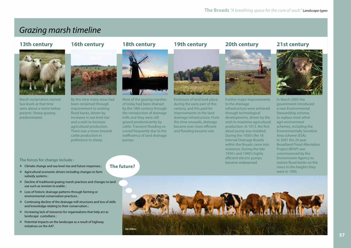
Grazing marsh timeline
The Broads "A breathing space for the cure of souls" Landscape types
13th century
Marsh reclamation started. Sea levels at that time were about a metre below present. Sheep grazing predominated.
18th century
Most of the grazing marshes of today had been drained by the 18th century through the introduction of drainage mills and they were still grazed predominantly by cattle. Transient flooding oc-curred frequently due to the inefficiency of land drainage pumps.
19th century
Enclosure of land took place during the early part of this century, and this paid for improvements to the land drainage infrastructure. From this time onwards, drainage became ever more efficient and flooding became rare.
20th century
Further major improvements to the drainage infrastructure were achieved through technological developments, driven by the wish to maximise agricultural production. In 1913, the first diesel pump was installed. During the 1930's the 18 Internal Drainage Boards within the Broads came into existence. During the late 1930's and 1940's highly efficient electric pumps became widespread.
16th century
By this time many areas had been reclaimed through improvement to existing flood banks, driven by increases in sea level rise and a wish to increase agricultural production. There was a move towards cattle production in preference to sheep.
21st century
In March 2005 the government introduced a new Environmental Stewardship scheme, to replace most other agri-environment schemes, including the Environmentally Sensitive Area scheme (ESA).In 2001 the 20 year Broadland Flood Alleviation Project (BFAP) was commissioned by the Environment Agency to restore flood banks on the rivers to the heights they were in 1995.
The forces for change include :lClimate change and sea level rise and future responses ;
lAgricultural economic drivers including changes to farm subsidy systems ;
lDecline of traditional grazing marsh practices and changes to land use such as revision to arable ;
lLoss of historic drainage patterns through farming or environmental conservation practices ;
lContinuing decline of the drainage mill structures and loss of skills and knowledge relating to their conservation ;
lIncreasing lack of resources for organisations that help act as landscape custodians ;
lPotential impacts on the landscape as a result of highway initiatives on the A47.
The future?
Ian Aitken
57

The Broads "A breathing space for the cure of souls" Landscape types
58

The Broads "A breathing space for the cure of souls" Landscape types
5 Peat "Fen" areasThe Broads has the largest expanse of species-rich fen in lowland Britain. Approximately 3200 hectares has been identified representing about 11% of the Broads area.
It is a landscape type strongly associated with peat soils and it tends to occupies marginally higher ground than the estuarine marshland. Aerial photographs and ordnance survey maps provide a good indication where this peat fen community with its associated carr woodland can be found.
Its distinctive landscape characteristics are:lIt is associated with peat soils;
l It can contain a mosaic of valuable habitats as a result of human intervention both currently and historically;
l If left unmanaged it woodland and scrub will encroach (natural succession);
l It can be remarkably rich in plant species which supports a range of invertebrate species;
l Many sites were provided common or poor’s allotments land around settlement;
l Failed attempts to drain the land can be seen in the remnant dyke network and mill structures.
Historically they are often formed the from the location of former wet common or poors allotment land. At some locations the relict medieval dole pattern of subdivision /drainage has been retained. At other locations evidence of attempts to drain the land, usually undertaken through the 19th century, can be found in the form of remnant rectilinear dyke networks. Occasionally the remnants of drainage mills can be found.
Through years of human management, cutting sedge for thatching, taking a hay crop and light grazing, the fens have developed a diverse vegetation mosaic, which is rich in invertebrates and plant species. Fens are strongly dependent on water supply, most are not embanked and many are therefore in direct contact with river water.
Peat fen areas have a mosaic of vegetation types providing good habitat
Simon Finlay 59

The Broads "A breathing space for the cure of souls" Landscape types
The peat fen areas may contain a mix of broads or former broads and decoy sites, reed and sedge beds, scrub, successional carr woodland and fen meadow. Management regimes or the lack of them can have a significant impact on the appearance of fen areas as natural succession, a process by which plant communities evolve over time, means that those areas that are not managed tend to develop more shrub/scrub and tree growth. In the upper Thurne where the soils are more mixed and saltier waters can be found there are some significant expanses of open fen.
There are three different locations where peat fen can be found.
The most extensive areas of the peat soils areas lie in upper reaches of the main river valleys in the Broads. They lie upstream of those areas which are characterised by the silty-clay soils which formed the extent of the Great Estuary. Examples of these areas can be found at Strumpshaw on the River Yare and How Hill on the River Ant.
The second most significant areas of peat lie within the side valley tributaries. These fingers of peat sometimes extending beyond the Broads executive boundary often go by the names of “Beck”, “Fleet” of “Run”. They also typically form Parish boundaries. These narrow incised valleys often contain small broads or decoy sites.
Examples of these locations include:Shallam DykeThurlton BeckDecoy and Hell Carr ( Acle, Tunstall, Moulton)Landspring Beck, Haddiscoe Hundred Drain at Barnby /North Cove
The third location for peat fen can be found, are as blocks lying on the valley sides. Examples can be found at Upton Fen, Buckenham and Hassingham Carrs
The forth location is very similar to the third but tend to be narrow fringes and most have now become carr woodland. These areas are lie where the silty clay soils of the estuarine marshland thin and narrow ribbons of peat deposits can be found. Examples can be found on the edges of Wheatacre and Limpenhoe marshes and on the western edge of Halvergate marshes.
Fen vegetation can be very rich in plants and includes species such as common reed, saw sedge, bottle sedge, hemp agrimony, marsh cinquefoil and milk parsley with characteristic fen meadow plants black bog rush, blunt flowered rush, marsh thistle, and purple moor grass.
Milk parsley provides the food plant for swallowtail butterfly caterpillars. Adult swallowtails feed on a range of other fen herbs, such as ragged robin and marsh birdsfoot trefoil.
Reed is harvested for thatching. The process of regular harvesting helps keep trees and scrub becoming established.Julian Claxton
Conservation management practices encourage species rich fen.
60

The Broads "A breathing space for the cure of souls" Landscape types
Forces for change include:
lThe fortunes of the reed and sedge cutting industry;
l Changes and the development of management techniques;
l Cost of intervention to prevent natural succession;
l Climate change and sea level rise and future responses;
l Agricultural economic drivers including changes to farm subsidy systems;
l Increasing lack of resources for organisations that help act as landscape custodians;
l Brackish (salty) water intrusion and water quality generally;
l Development pressures for recreational use;
l Increasing landownership by nature conservation organisations.
The range of plants to be found in peat fen supports
many animals. Images on this page
- Jackie Dent
61

The Broads "A breathing space for the cure of souls" Landscape types
6 Upper river valley marshlandsThis type can be found where the soils type, generally silty clay or clay /peat mix, become more assorted. They are often in a transitional zone between the peat soils at the upper end and sides of the valleys within the area and the silty clays of the estuarine marshes. Occasionally the soil mix includes sand and gravels.
Superficially they can exhibit similar characteristics the estuarine marshes landscape type; however over time these areas have been subjected to subtle land use differences. The two largest areas of this type in the broads lie in the upper reaches of the River Thurne in the northern Broads and the area of land to the west of Beccles.
Historically these areas have the established land use of grazing. In the River Thurne however a significant proportion of the area has been deep drained and is used for arable production. In the Waveney the predominant use is still grazing.
Where these mixed soils conditions exist on the valley sides they can provide the location for settlement fringe activities as the ground can be very marginally drier than the adjacent marshland encouraging more “domestic” types of use of the areas. Ironically though if clay soils are present they can provide a location for ponds and scrapes as the water will be more readily retained.
One of the larger areas of this landscape type can be found in the upper reaches of the River Thurne. Deep drainage in this area has led to shrinkage of the peat lowering overall ground levels.Don Cload - geograph.org.uk
Much of the Waveney Valley to the west of Beccles (within the Broads area) is of this type. Traditionally these areas have tended to be used for grazing. Evelyn Simak - geograph.org.uk
62

The Broads "A breathing space for the cure of souls" Landscape types
Its distinctive landscape characteristics are:lLocated in the upper reaches of the rivers within the Broads areas or on the valley sides where soils types are mixed;
l The marshes are divided into “fields” by drainage dykes and ditches. Some areas are deep drained;
l Vegetation patterns are varied;
l Landscape patterns tend to be fragmented;
l Land use predominantly grazing;
l Arable reversion concentrated in some areas;
l Expansive views often to locations outside the Broads area and “Big skies”;
l Some settlement fringe activities.
Forces for change include:lClimate change and sea level rise and future responses;
l Agricultural economic drivers including changes to farm subsidy systems;
l Land shrinkage (Thurne);
l Decline of traditional grazing marsh practices and changes to land use such as revision to arable;
l Fen creation on agricultural land;
l Increasing lack of resources for organisations that act as landscape custodians;
l Increased pressures for leisure/recreational activities especially on the valley side locations.
Where this landscape type exists in close proximity to settlement and coincides with soil types which are either
more readily drained (sandy gravels), or water retentive(clays), pressures for recreational or leisure activities can be
significant forces for land use change.Evelyn Simak - geograph.org.uk
The valley edges are often transitional areas where the mix of soils types found can lead to a more fragmented landscape character and result in different vegetation types. Evelyn Simak - geograph.org.uk
The landscape patterns formed by field sizes, vegetation and colours, tend to be significantly more complex than the simplistic ones found within the estuarine marshes type. Keith Evans - geograph.org.uk
63

The Broads "A breathing space for the cure of souls" Landscape types
7 BroadsBroads, which give the area its name, are in the main only found in the middle to upper reaches of the north-ern river valleys in the Broads National Park. There are 63 Broads covering 841 hectares. Hickling is the largest of the Broads and Sotshole is the smallest.
They were originally thought to be natural features but in 1834, from his observations at Barton, Samuel Woodward first suggested the Broads were not natural but dug by human hand. It wasn’t until research in the 1950s and 60s by Joyce Lambert however, that it was established that these ‘lakes’ were in fact man-made features created as a result of excavation of the peat for fuel.
The majority of the Broads surviving today were theresult of these peat excavations becoming flooded, but some are the result of flooded sand and gravel extraction pits such as the relatively recently excavated Whitlingham Broad.
Its distinctive landscape characteristics are:lThey are bodies of open water of varying size;
l The majority are located within the peat soils of the middle to upper reaches of the river systems and mainly in the northern Broads rivers of the Yare, Thurne, Bure and Ant;
l They can either be isolated water bodies (not navigable) from the main rivers e.g. the Trinity Broads , accessed by via a channel linking them to the main river e.g. Malthouse and Wroxham Broad or they actually lie on the line of the main river e.g. Barton;
l Over time vegetation tends to encroach from the edges on many broads reducing their size;
l Some have the tendency to silt up effecting water quality and biodiversity;
l A number have been completely lost over time;
l The wet soils on the margins of those broads in the peat areas support fen/carr vegetation;
l Their character is greatly influenced by the size of broad and the type of and management regime for the vegetation surrounding the broads;
l The water quality ( nutrients/ salinity/ turbidity) of the individual broads can vary significantly influencing the presence and type of water plants;
l Where they are open for navigation, they provide a popular destination for boat traffic providing a sense of activity especially during the height of the tourist season;
l Where they are closed to navigation they can provide tranquil refuges for wildlife;
l The majority of broads have little or no visible development fronting the edge of the broad adding to their sense of seclusion.
A busy day at Barton Broad.Simon Finlay
64

The Broads "A breathing space for the cure of souls" Landscape types
History of peat broadsTurberies (areas where there is a legal right to cut peat for fuel) are likely to have existed in the 11th century but probably as shallower extractions of surface phragmites peat (peat formed from decomposed reed). Population increases and the use of peat in the salt industry are thought to have led to an increased demand for fuel in the 12th century. Historic records indicate that the industry was immense. It the 1960's it was estimated that approximately 900 million cubic feet of peat was been removed through peat digging. However, this is likely to be an underestimate as the national mapping project (a project to map historic features from aerial photos) established that the extent of broads actually exceeded the available map based evidence at that time.
It is quite likely that the peat excavations were subject to flooding during the second half of the 13th century and the 14th century when there were periods of severe storms and flooding in the North Sea basin, with frequent records of flooding in Eastern England and Holland. For example, in 1287 the sea broke through between Palling and Horsey on the northeast coast and also in the Yarmouth area, and inundated the marshes and villages, with floods reaching beyond St Benet’s Abbey. Peat extraction appeared to be on the decline from the 15th century onwards as a result of the decrease in population and therefore decreased need for fuel and rising sea levels.
Gradually the excavated areas filled with water to be used as fisheries and large scale duck ponds. The term "broad" was not used frequently as a land assessment term until the 14th and 15th century.
Research has found that the peat was often cut to a depth of up to 3-5 metres and that within the areas excavated there were islands and strips of untouched peat. These are called peat baulks. Some of these remain today although many have disappeared as a result of erosion and dredging activities.
The character of the broadsEach broad has its’ own individual character. But two landscape characteristics when combined can provide a rough division into two sub types of “open” and “enclosed” broads. These are the size of the broad and the nature of the vegetation which surrounds the broad.
“Enclosed” broads such as Ranworth, South Walsham and Cockshoot are characterised by a far greater sense of enclosure as a result of their size combined with the surrounding carr woodland, than those of the “open” broads such as Hickling, Horsey and Martham, which are embanked and reed fringed.
Other factors contributing to their individual character include water quality. Where it is good and the water is clear healthy aquatic communities can be found supporting a greater range of wildlife.
The sense of tranquillity experienced on the broads is influenced by the lack of visible development from the broad, the availability of boat access and other recreational activities that may take place on the water. During the summer months those broads which are navigable can be exceptionally busy with holiday boating traffic, which when combined with regattas held by the local sailing club, can provide for exciting action packed boat journeys by others through the broads. The winter season bring a reduction in human activity but an increase in wildlife activity as many birds travel to the UK and use the broads as winter refuges.
The "open" broad of Hickling with wide fringing reed beds.Images Mike Page
The "enclosed" broads of Ranworth and malthouse with
carr woodland surrounding the water.
65

The Broads "A breathing space for the cure of souls" Landscape types
Forces for change include:lChanges to water quality both positive and negative thereby improving/ reducing biodiversity value;
lEncroachment of carr woodland fringe shading out the water body and reducing its size;
lRecreational and development pressures which can reduce the sense of tranquillity and isolation;
lInvasive and alien plant and animal species which can change the natural ecological balance;
lErosion /management of reed margins;
lSiltation of broads can effect biodiversity value and recreational activities;
lDredging/mudpumping operations and disposal of sediment for management for navigations and water quality.
Simon Finlay
66

The Broads "A breathing space for the cure of souls" Landscape types
8 Carr woodland
The woodland mosaic includes willow scrub, birch scrub and alder carr woodland, in relatively even-aged stands with oak woodland on higher ground. Alluvial alder woodland is considered of international importance. The different stand types have an associated ground flora which includes great tussock sedge, yellow loosestrife and yellow pimpernel. In some places woodland grades subtly into scrub, fen, marginal vegetation and open water.
Carr woodland is the name given to wet woodland. The Broads has the most extensive tracts of wet woodland in lowland Britain and covers approximately 5% of the area. They are in the main located on the river flood plains and along smaller streams. Ribbons of carr woodland can be found however, on the valley sides at the outer extents of where the silty clays of the estuarine marsh give way to peat soils.
The biodiversity of these woodlands is of international importance. Some of the areas have been wooded for over a hundred years, and they were once coppiced for wood products. Other wooded areas are relatively recent having regrown from areas previously cleared.
In the wetter locations the woodland floats on “hover” which is a crust of peat soils under which lie liquid soils. This creates very unstable conditions and trees often fall over making it very unsafe to walk on.
Many of the woodlands are now unmanaged and comprise an almost untouched plant and animal community subject to little disturbance.
Its distinctive landscape characteristics are:l It is associated with wet, peat soils ;
l Much of it is now unmanaged providing undisturbed areas for wildlife ;
l The woodland edges provide valuable habitats ;
l They provide a sense of enclosure for users of the rivers ;
l Located within the narrower valley reaches their presence often provides an important visual buffer of river users to the more developed areas beyond.
Barton boardwalk which passes through the carr woodland. These woodlands “float” or hover making the ground conditions very unstable. Lesley Marsden
Carr woodland at Barton Broad. Mike Page
Tussock sedges are one of many interesting types of plants that can be found in carr woodland. They stand so tall from the ground that different species inhabit different levels in the plant. Lesley Marsden
67

The Broads "A breathing space for the cure of souls" Landscape types
Alderwoods are particularly noted along the Waveney Valley, which were once coppiced regularly to supply straight poles to make charcoal for the gunpowder industry. Today alder is re-coppiced in some woodlands providing straight poles for piling, which is used to give a more natural edge to protected banks.
The Carr woodlands are a key landscape feature in the middle to upper sections of the Broads rivers. As well as their importance as a habitat they provide a sense of enclosure contain views both into and out from the Broads and rivers and help to buffer the visual effects of development on the Broads. They are not always a welcome feature however, as they tend to limit sailing
opportunities and the shade they create can be at the expense of some of the more species rich
communities that can be found in the Broads.
Forces for change include:l Climate change and water level rises;
l Disease (Phytophthora) which has seen the loss of significant areas of alder;
l Coppicing which can have temporary visual effects;
l Conservation management involving tree removal to promote other habitats;
l Clearance for sailing purposes;
l Clearance as a result of development and/or land raising.
The carr woodland provides a sense of enclosure and helps at some locations to provide a good visual buffer to the more built up areas beyond. Lesley Marsden68

The Broads "A breathing space for the cure of souls" Landscape types
9 HeathlandAround 1% of the Broads area is heathland or dry acid grassland. It occurs on the higher land and valley sides above wet woodland and fen and reed bed habitat.
Heathland is characterised by the presence of shrubs such as ling heather and European gorse, forming a mosaic with acid grassland and bracken. Acid grassland is characterised by grasses such as sheeps fescue and common bent with sheep’s sorrel, heath bedstraw and tormentil. The drier land with gorse and bracken is particularly favoured by adder.
The soils of many of the “upland” areas in the Broads provides the right conditions for the heathland type they were prior to the land being cleared for farming centuries ago.
Forces for change include:l Pressure for sand and gravel extraction;
l Extension to golf course development or facilities;
l Pressures for recreational or other leisure development;
l Potential heathland restoration;
l Conifer plantation management.
Forces for change include:l It is associated with sandy soils so they are free draining;
l They have a distinctive type of vegetation e.g. bracken, gorse birch;
l They are often areas of dry common land;
l They occur in a fragmentary way around the periphery of the Broads system extending into the adjacent districts;
l Some areas have been the subject of recreational development such as golf courses;
l Some areas have been used for plantations.
At East Ruston the heathland vegetation provides habitat for the silver studded blue butterfly. Stephanie Anderson
At Outney Common part of it was developed as a golf course. Evelyn Simak - geograph.org.uk
The Waveney Forest is an area of plantation forest.
Herringfleet Hills is an area of open access land.
Evelyn Simak - geograph.org.uk Evelyn Simak - geograph.org.uk
Evelyn Simak - geograph.org.uk
69

The Broads "A breathing space for the cure of souls" Landscape types
10 Settled BroadsAlthough there are a number of isolated farms and cottages that are located in the marsh landscape, the majority of settlement associated with the Broads area lies on the edges of the floodplain. These settlements are normally a mix of holiday/residential properties and commercial and agricultural development. They can be broadly separated into a series of sub groups which are set out in the following text. Many of the developed areas fringing the rivers and marsh areas can be a mix of these sub types.
Generally the location of settlement was dictated by the need to be close to the river systems which used to provide the main links for transporting goods and materials around the area and to places further afield.
Many of the towns and villages have staithes which are areas of land providing access to the river or broad where the loading and unloading of cargo used to take place. The name comes from the anglo saxon word staeth. Today the staithes tend to be used for recreational purposes although reed and sedge harvests are sometimes still offloaded from boats.
Its distinctive landscape characteristics are:lTraditional building materials for residential properties were originally locally sourced and included Norfolk brick, flint and thatched roofs;
lThere is a range of building styles and materials used within the Broads dictated by period of construction and location;
lBuildings constructed after better rail and road connections were established have tended to be constructed from materials from further afield;
lThe majority of residential property is located on the slightly higher ground of the valley side outside the floodplain;
lSettlements tend to be nucleated (clustered around a river crossing or staithe) or linear in nature following the roads that skirt around the edge of the river valley or the river itself;
lAt certain locations, poor ground conditions and the potential of flooding has dictated the need for structures to be piled and the use of lighter weight building materials;
lThe interwar popularity of the area for holidays saw the emergence of contrasting scales of development from small chalets to substantial dwelling with large plots;
lThe smaller traditional boatyards have declined in number whilst extensive modern boatyards and marinas to accommodate much larger craft have increased in number;
lMany of the settled broad’s areas have resulted in the canalising of the river frontages through the use of quay heading.
Settled Broads SubtypesLinear “Low Road” settlements which predominately comprise farmsteads and cottages located at the upland edge of the floodplain following the roads that hug the valley. Examples include Langley, Hardley, Rockland, Burgh Castle, Horning and Haddiscoe.
Langley is an example of a linear settlement located on a roadway which follows the valley side.
Horning lies along the northern side of the River Bure .
Mike Page
© Crown copyright and database rights 2016. Ordnance Survey licence number 100021573
70
The Broads "A breathing space for the cure of souls" Landscape types
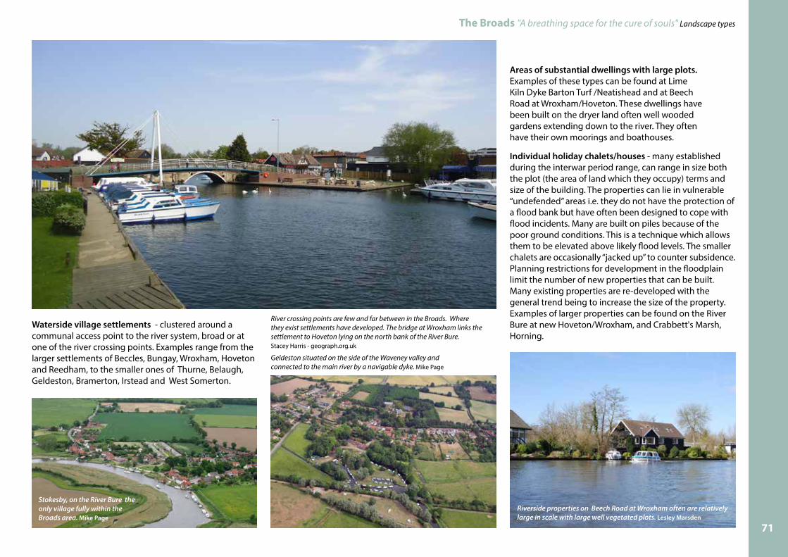
Waterside village settlements - clustered around a communal access point to the river system, broad or at one of the river crossing points. Examples range from the larger settlements of Beccles, Bungay, Wroxham, Hoveton and Reedham, to the smaller ones of Thurne, Belaugh, Geldeston, Bramerton, Irstead and West Somerton.
Areas of substantial dwellings with large plots. Examples of these types can be found at Lime Kiln Dyke Barton Turf /Neatishead and at Beech Road at Wroxham/Hoveton. These dwellings have been built on the dryer land often well wooded gardens extending down to the river. They often have their own moorings and boathouses.
Individual holiday chalets/houses - many established during the interwar period range, can range in size both the plot (the area of land which they occupy) terms and size of the building. The properties can lie in vulnerable “undefended” areas i.e. they do not have the protection of a flood bank but have often been designed to cope with flood incidents. Many are built on piles because of the poor ground conditions. This is a technique which allows them to be elevated above likely flood levels. The smaller chalets are occasionally “jacked up” to counter subsidence. Planning restrictions for development in the floodplain limit the number of new properties that can be built. Many existing properties are re-developed with the general trend being to increase the size of the property. Examples of larger properties can be found on the River Bure at new Hoveton/Wroxham, and Crabbett's Marsh, Horning.
Stokesby, on the River Bure the only village fully within the Broads area. Mike Page
Riverside properties on Beech Road at Wroxham often are relatively large in scale with large well vegetated plots. Lesley Marsden
Geldeston situated on the side of the Waveney valley and connected to the main river by a navigable dyke. Mike Page
River crossing points are few and far between in the Broads. Where they exist settlements have developed. The bridge at Wroxham links the settlement to Hoveton lying on the north bank of the River Bure. Stacey Harris - geograph.org.uk
71

The Broads "A breathing space for the cure of souls" Landscape types
More modest properties can be found on the River Thurne at Potter Heigham / Repps and the River Yare at Brundall.can be found at Brundall, St Olaves, Wroxham, Horning, Potter Heigham, Stalham and Burgh Castle.
Small Boatyards and associated mooring facilities - small traditional boatyards still exist often building and maintaining the smaller sailing vessels. Traditionally the workshops tended to be of timber construction and many have a wet dock inside the building. Examples of smaller types of boatyards can be found at Sutton, Somerleyton Womack Staithe and Ludham Bridge.
Extensive modern Boatyard/marina developments – much like the modern car, boats (motor cruisers in particular) have tended to increase in size as holiday makers have come to desire all the mod cons of home living on a boat. The Broads has also seen an increase in private boat ownership in recent years. Larger boats have led to an increase in the size of the facilities needed to service the craft. An increase in private ownership has led to a pressure for more boat moorings. Companies who build boats no longer require a waterside environment as transportation methods have changed. Many have therefore found alternative accommodation on local industrial estates. Examples of extensive modern boatyard developments can be found at Brundall, St Olaves, Wroxham, Horning, Potter Heigham, Stalham and Burgh Castle.
Contrasting house styles and sizes can been seen in the same location. When plots are redeveloped there is a tendency to increase the size of the property with the potential to impact on the opportunity to incorporate or retain trees within the gardens. The presence of trees helps to “soften” the hard lines and scale of the buildings.
The modern motor cruiser is now much larger in size bringing about development pressures to build larger buildings to house waterside boat operations. Evelyn Simak - geograph.org.ukThe riverside chalets at Potter Heigham/ Repps
and Brundall tend to be more modest in size.
Traditional wooden sailing crafts require smaller buildings for storage and maintenance. Nick Smith - geograph.org.uk
72

Major towns or citiesThe main rivers of the Broads flow through Norwich, Great Yarmouth and Lowestoft (Oulton Broad). Great Yarmouth still has a port function especially in relation to offshore industry. Norwich and Lowestoft(Oulton Broad) are now home to holiday boat traffic. The warehouses and buildings that serviced the river trade are gradually disappearing or are being converted or redeveloped for mainly residential purposes.
The Broads "A breathing space for the cure of souls" Landscape types
Forces for change include:lEffects of climate change and water level rises effecting finished floor levels (overall height of development and plot levels) and access provision;
lLoss of traditional settlement patterns due to continuing pressures for both commercial and residential property;
lLarger residential landholdings being subdivided potentially leading to pressures on mature vegetation;
lThe increase size and numbers of boatyard and marina development which has the potential to encroach on the natural/ semi natural environment;
lSettlement expansion and the increased recreational pressures it causes;
lIncreased numbers of boat owners who require mooring either in marinas or adjacent to properties;
lEconomic pressures for land use change from business purposes e.g. small boatyards to higher value residential/holiday accommodation;
lRe-development of the smaller leisure plots and their chalets to be replaced by larger properties;
lLoss of buffering vegetation between properties or plots;
lThe design of buildings and use of building materials which have incongruous effect on the local setting;
lExpansion of leisure facilities presents opportunities for enhancement which need to be balanced with adverse effects.
Modern land based holiday and leisure areasThe Broads is a popular tourist and recreational area which has resulted in the development of a range of commercial developments to accommodate the local population and visitors alike. The larger camping and caravan sites and mobile home parks can be found in the main around the periphery of the Broads on the higher ground of the valley sides where the soils are freer draining. Examples can be found around Burgh Castle, Fleggburgh St Margaret and Burgh St Peter. Golf courses have become established on the sandier heathland areas that exist on the periphery of the area within the Waveney valley. Bewilderwood, an adventure playground, has made use of existing woodland areas on the Bure.
Designed landscape and ornamental gardens A number of these exist around the Broads area and each has a different character. Crown Point Park, Hoveton House, Brundall Gardens, Fairhaven Gardens and How Hill are all gardens which were or still are associated with large properties. The unusual one in the mix is garden of Long Gores at Hickling which contains an island created in the shape of a double headed eagle by ecologist and botanical artist Marietta Pallis who bought the property in the 1930’s.
The hard quay headed frontage in Norwich and riverside buildings originally used for commercial purposes has been converted into residential. Modern infill development is also residential . N. Chadwick - geograph.org.uk
The island created my Marietta Pallis is her last resting place, as she was buried here with her partner Phyllis Clark.
Marinas and mobile home developments at Burgh Castle close to Great Yarmouth.
Images Mike Page
The town of Gt Yarmouth with hard quay heading is still an active port now serving the off shore industry. Christine Johnstone - geograph.org.uk 73

The Broads "A breathing space for the cure of souls" Landscape types
11 Settlement FringeThis landscape type represents those areas of land found repeatedly throughout the Broads where development pressures of all types and semi natural/natural environment converge. Invariably at these locations pressures for land use other than for traditional agricultural exist. Many of these are a generated as a result of activities associated with increased recreational and leisure time. The types of land use pressures are varied and include garden extensions with their associated fencing and features; allotments, poultry keeping, horse keeping, sports pitches, pond construction (fishing and wildfowling) and storage of scrap items etc.
Additionally the proximity of a settlement can influence the presence and extent of strategic infrastructure such at the poles and cables for telecoms and electricity supply.
The land which is subject to these types of development pressure will generally have the basic underlying characteristics of the prevailing landscape type within the locality but invariably if used for such activities can become heavily modified though the annexation; subdivision; change of use; introduction of ancillary buildings and structures which meet the needs of the activity.
Its distinctive landscape characteristics are:lThe basic underlying landscape characteristics are the same as the prevailing landscape type within the character area i.e. estuarine marshland/ heathland etc.;
l The basic landscape characteristics associated with the existing natural/semi natural environment have been compromised;
l They are always located in close proximity to existing settlement;
l The landscape has been modified in some way to accommodate the intended use;
l Features may have be added that look out of character with the semi natural environment of the Broads;
l The activities may have the potential to impact on the soils, vegetation, water quality and tranquillity of an area.
The changes effected on the areas of land which are subject to these activities can both individually, (depending on their scale and nature) and cumulatively (if it is following a trend in an area), have an effect on the landscape character of an area, through changes to the traditional land use and land cover.
Many activities and land use changes will require planning approval. As part of that process, consideration to their likely effects (both positive and negative) on the landscape character of an area will be one of the many aspects that the planning authority will need to consider.
However, there are many areas in the Broads where traditional landscape features and elements are being eroded as a result of unauthorised and unsympathetic development or by activities that do not require specific permissions.
At certain locations within the Broads unauthorised activities or significant pressures have triggered the establishment of an Article 4 Direction. This is a special planning regulation which can be adopted by a Planning Authority to cover all or part of their executive area. It operates by removing permitted development rights from whatever is specified in the Article 4 Direction. The Broads has a number of these Article 4 Directions within its boundaries.
Different activities have the potential to effect landscape in different ways. They may cause direct impacts on both the landscape (soils, water, vegetation etc.) and/or the perceptual qualities of an area including views. Overall the effects may be so great that they may have the effect of urbanising the semi natural/natural environment.
What follows are some examples of landscape issues which may have an adverse impact on the local landscape character.
Phone and electricity poles and cables can create visual clutter. Lesley Marsden
Quay headed frontages installed in the countryside can impact on wildlife habitat by creating an unnatural bank edge. Lesley Marsden
74

The Broads "A breathing space for the cure of souls" Landscape types
Forces for change include:lAn increase in housing development in close proximity to the Broads area and therefore recreational / leisure pressures generated on agricultural land;
l An increase in horse ownership;
l Land values which may dictate the economic viability of land use;
l Increasing popularity for coarse fishing leading to more excavations for ponds;
l Wildfowling increasing the number of pond excavations;
l Projects to underground overhead electricity cables.
Excavations for ponds for wildfowling /fishing etc.
lThe shape, depth and profile of the excavations can look unnatural;
lPond edges not designed to support marginal plant species;
lMaterial dug out is not disposed of in an appropriate manner;
lPeat, (which is a valuable landscape resource) is excavated;
lAncillary structures introduced to support the activity look out of character;
lInappropriate planting.
Garden extensions:
lInappropriate ornamental planting introduced into a semi natural/natural environment;
lLayout, the materials used and manicured appearance can look out of character;
lGarden buildings, fencing and features can look out of character;
lLoss of natural/semi natural habitat.
Horse keeping:
lLoss of natural/ semi natural habitat from changing in relation to grazing management and construction of ménages;
lIntroduction of fencing can look cluttered and out of character;
lWater quality – storage of used bedding materials adjacent to waterways;
lBuildings for storage of feedstuffs and equipment;
lStabling blocks;
lLighting.
Different fencing styles, storage containers, summer houses and types of planting can together start to urbanise a location lying within the countryside.Lesley Marsden
Animal keeping / smallholdings on the edges of settlements can create piecemeal development.
Ménage under construction - An increase in horse ownership has led to agricultural (often grazing marsh) land being developed to provide stabling and exercise facilities.Lesley Marsden
Horse grazing requirements can lead to additional fencing and shelter requirements.Lesley Marsden
Lesley Marsden
75

The Broads "A breathing space for the cure of souls" Landscape types
12 Industrial and post industrialIndustrial and post-industrial – disturbed or made up ground type, relates to more recent disturbance through landfill, commercial, quarrying and dredging operations. Most of these areas of disturbed ground which fall within this category lie on the outer edges of the Broads area at locations where mineral deposits are located close to the surface and/or close to the larger areas of settlement.
Its distinctive landscape characteristics are:lThe soils and sub strata could have been significantly disturbed;
l Ground levels could have been altered;
l Some are still in a state of change;
l Some areas have been restored or reclaimed;
l Most sites within this type, other than dredging sites, lie on the river valley sides;
l Some of the commercial operations within this type require ancillary buildings and plant.
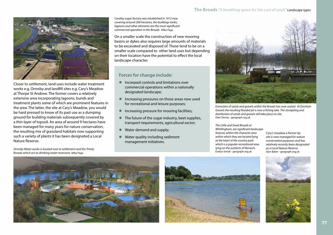
The exception to this are those areas which are being or have been used for dredging disposal sites. The Broads Authority undertakes the majority of dredging operations in the area as they have a responsibility to maintain the main rivers within the executive boundary for navigation purposes. There is one large disposal site at Postwick, but most material is disposed of in areas within relatively close proximity to where it is dredged from. These dredging operations are completed in a relatively short timescale, are small in area and are transitory in nature. For the purposes of the landscape character assessment process they have been included as part of the river, ronds and floodbanks types but require some elaboration in this type because of the nature of the land disturbance involved.
In 2001 a major contract was awarded by theEnvironment Agency to undertake works to strengthen the existing floodbanks resulting in perhaps the greatest amount of landscape change for centuries to certain areas in the Broads. The Broadland Flood Alleviation project (BFAP) provided opportunities for new dredging disposal sites throughout the Broads. In certain areas the flood defences were re-aligned or “setback” (up to 30m) behind the existing bank via the construction of a new floodbank in the adjacent grazing marshes. This technique results in a substantial increase in rond width (the vegetated area between the flood embankment and the river).
Once the integrity of the new floodbank is established, the dilapidated erosion protection materials along the river front (usually sheet metal piles) is removed, and the old bank is re-profiled to a low level earth platform just above the height of mean (average) high tide. The area in front of the new bank (a lagoon) is ideally suited to receive river dredgings. Once dredging disposal has ceased, emergent vegetation (usually dominated by reed), quickly colonises the shallow aquatic margins and expands across the area where dredged silt has been placed, to produce a mosaic of reedbed and tidally controlled open water habitats.
All extraction operations for gravel and sand have now ceased within the Broads. The last of these were at Whitlingham/Thorpe Marshes, near Norwich and at Earsham on the River Waveney. Each of these operations have resulted in large expanses of water (new broads) which are now used for recreational purposes but through gradual re-colonisation by plants and animals they will add to the diversity of habitats in the Broads.
Cantley Sugar factory is the largest commercial operation within the Broads area. The sugar beet industry as we know it today began in the 1900’s and resulted in the construction of the factory being built in 1912 at Cantley. The scale of the current operational areas is significant with vast buildings, storage tanks, plant, lagoons and stockpiles extending to around 200 hectares. The processing “campaign” begins in the autumn when the sugar beet is lifted from the fields. Today the operation also involves reclaiming and recycling the soil and the stone that come in with the beet loads as well as the “waste” energy generated by parts of the operation. The steam plumes which come from the tall chimneys during the winter period can be seen for kilometres.
Sections of the River Ant have seen the setback of the floodbanks so providing sites for material dredged from the river. Mike Page.
Emergent vegetation expands across the shallow aquatic margins of the setback lagoon following disposal of dredged material from the river by the Broadland Authority on the River Ant.Lesley Marsden
76
The Broads "A breathing space for the cure of souls" Landscape types
Forces for change include:lIncreased controls and limitations over commercial operations within a nationally designated landscape;
l Increasing pressures on those areas now used for recreational and leisure purposes;
l Increasing pressure for mooring facilities;
l The future of the sugar industry, beet supplies, transport requirements, agricultural sector;
l Water demand and supply;
l Water quality including sediment management initiatives.
Closer to settlement, land uses include water treatment works e.g. Ormsby and landfill sites e.g. Cary’s Meadow at Thorpe St Andrew. The former covers a relatively extensive area incorporating lagoons, bunds and treatment plants some of which are prominent features in the area. The latter, the site at Cary’s Meadow, you would be hard pressed to know of its past use as a dumping ground for building materials subsequently covered by a thin layer of topsoil. An area of around 9 hectares have been managed for many years for nature conservation, the resulting mix of grassland habitats now supporting such a variety of plants it has been designated a Local Nature Reserve.
On a smaller scale the construction of new mooring basins or dykes also requires large amounts of materials to be excavated and disposed of. These tend to be on a smaller scale compared to other land uses but depending on their location have the potential to effect the local landscape character.
Ormsby Water works is located next to settlement and the Trinity Broads which act as drinking water reservoirs. Mike Page
Cantley sugar factory was established in 1912 now covering around 200 hectares, the buildings tanks, lagoons and other elements are the most significant commercial operation in the Broads. Mike Page
Extraction of sands and gravels within the Broads has now ceased. At Earsham Gravels the resulting flooded pit is now a fishing lake. The stockpiling and distribution of sands and gravels still take place on site. Glen Denny - geograph.org.uk
The Little and Great Broads at Whitlingham, are significant landscape features within the character area within which they are located lying at the heart of the country park which is a popular recreational area lying on the outskirts of Norwich. Evelyn Simak - geograph.org.uk
Cary’s meadow a former tip site is now managed for nature conservation purposes and has relatively recently been designated as a Local Nature Reserve.Glyn Baker - geograph.org.uk
77

SUFFOLK
NORFOLK
Acle
Brundall
Ludham
Reedham
Wroxham
LOWESTOFT
Potter Heigham
BecclesBungay
Gillingham
Horning
Hoveton
Rockland St Mary
Filby
Stalham
Smallburgh
Ranworth
Salhouse
Loddon
Chedgrave
Haddiscoe
Hickling
St Olaves
Neatishead
Horstead
Woodbastwick
Stokesby
Caister-on-Sea
Burgh St Peter
Fritton
UptonSouth Walsham
Barton Turf
Claxton
BramertonBurgh Castle
Horsey
Waxham
Gt YARMOUTH
Martham
Winterton-on-Sea
Broads Authority executive area
Upland areas
approx scale2 km
2 miles
0
0
© Crown Copyright and database right 2016. Ordnance Survey 100021573.
The Broads "A breathing space for the cure of souls" Landscape types
13 UplandsThis landscape type refers to “upland” only in the relative sense of the ground level differences between much of the Broads floodplain area (normally around 0 OD or less) and the valley sides and ridge lines ranging from around 1– 40 metres OD.
This type can be split into two, their linking characteristic is that they do not tend to exhibit the general characteristics found in the wetter landscapes. The areas typically have brown soils and they are usually in arable use. They have sometimes been included within the Broads Authority’s area where the executive area boundary has for example followed a road or railway. However, despite not exhibiting those wetland characteristics associated with the Broads, they are still subject to the same protection afforded to the rest of the area.
Its distinctive landscape characteristics are:lThe ground levels are at a higher level (OD) than other types;
l They are often potentially rich areas for archaeology;
l Soils tend to be different to the adjacent areas;
l They are often in arable use;
l They do not exhibit the same types of drainage networks associated with wetland areas;
l Vegetation types reflect the drier conditions and the different soil types.
78

The Broads "A breathing space for the cure of souls" Landscape types
Forces for change include:lThe natural functioning of rivers may impact on the setting of the Islands or Holmes;
lProposals for the promotion to grassland reversion to reduce nitrate conversion threatened due to funding constraints;
lCertain areas provide valuable sand/gravel extraction opportunities;
lThere are significant development pressures from settlement of different types within upland areas which may have implications for the “setting” and skylines of the Broads area.
Valley sides The first sub type includes those areas which form the gently sloping land from near to the valley floor to the valley crest. The landscape characteristics tend to be more in keeping with those areas of land which often lie outside the Broads Authority’s executive area. For this reason certain parts of the Broads area are more naturally associated with those areas which have been described in the adjacent Local Authority's own landscape character assessment. Please follow the links on the map (page 78) to each council districts's Landscape Character Assessment.
Islands or HolmesThe second sub type are slightly higher areas of ground within a low-lying situation. They have been formed by glacial deposits which are of a different soils/geology. Isolated farmsteads (or former sites) are often associated with them.
Heigham Holmes Somerton Holmes
Cow Holm
Images, Evelyn Simak - geograph.org.uk
Evelyn Simak - geograph.org.uk
Graham Horn - geograph.org.uk
Evelyn Simak - geograph.org.uk
79

![Venables v News Group Newspapers Ltd and others Thompson v ... · 430 Venables v News Group Newspapers Ltd (Fam D) [2001] Fam Family Division A Venables v News Group Newspapers Ltd](https://img.pdfslide.net/doc/110x75/5e834fca37f0d4260747a1c8/venables-v-news-group-newspapers-ltd-and-others-thompson-v-430-venables-v-news.jpg)

![Panduan Penggunaan SIMAK untuk Operator Program Studi simak-1.pdf2015 [Panduan Penggunaan SIMAK untuk Operator Program Studi] Lembaga Akreditasi Mandiri Pendidikan Tinggi Kesehatan](https://img.pdfslide.net/doc/110x75/5c858d7909d3f2b27b8cf843/panduan-penggunaan-simak-untuk-operator-program-simak-1pdf2015-panduan-penggunaan.jpg)