Embed Size (px)
Citation preview
Section 3: Flood Table of Contents WHY ARE FLOODS A THREAT TO DOUGLAS COUNTY? History Of Flooding In Douglas County What Factors Create Flood Risk? Flood Terminology Characteristics Of Flooding What Is The Effect Of Development On Floods? How Are Flood-Prone Areas Identified? HAZARD ASSESSMENT Hazard Identification Vulnerability Assessment Risk Analysis COMMUNITY FLOOD ISSUES What Is Susceptible To Damage During A Flood Event? Flood Mitigation Activities Community Rating System (CRS) Community Issues Summary FLOOD MITIGATION ACTION ITEMS
Why are Floods a Threat to Douglas County? Flooding represents the most common and best known of the natural hazard threats in Douglas County. They also encompass the broadest range of characteristics among natural hazards. Floods can occur quickly, as in flash floods, or slowly, as those resulting from the spring thaws. Floods can be of extreme magnitudes in confined locations, such as canyons, or a costly nuisance, as in broad river valleys. The topography and geology of the Umpqua River Basin are conducive to runoff, and peak flows on many of the tributaries occur within hours of the passage of weather fronts. Historically, the highest flows usually occur during the period from November through March as a result of the heavy rains augmented by snow melts. Heavy rains in Douglas County occur on a semi-annual basis and often affects the safety of property and/or life as does major flooding events. There are over 320 miles of river or major streams that flow through Douglas County, with an estimated 24,396 acres of land in the 100-year floodplain. Flooding can pose a threat to life and safety, and can cause severe damage to public and private property. The county was most recently affected by flooding in the winter of 1996. The regional floods of November and December1996 surpassed the county’s normal seasonal flood events. A heavy rainstorm occurred in Douglas County on November 17, 18 and 19, 1996. The storm delivered between 2-4 inches of rain in one night depending on location. Many of the rivers and smaller tributaries in the county quickly reached their flood levels, causing flooding. The flooding warranted road closures (including washing out a portion of Interstate 5 near Roseburg) and the evacuation of some homes in the County. Strong winter storms beginning in early December 1996 and continued through December 15, 1996 began building the snowpack over the southwestern portion of the state. Water equivalent of the snow pack ranged from 2-6 inches in southwest Oregon. Widespread rain showers followed the storm that brought heavy snows to the Cascade Mountains on December 19 and 20, 1996. Beginning on December 25, 1996 a moist weather front, originating near the Hawaiian Islands, began moving toward Oregon. This front moved inland over the state, starting a series of storms that lasted through January 1, 1997. The moist front that existed during this period produced repeated periods of moderate to heavy rainfall and the freezing level to above 10,000 feet by December 30, 1996. The melting snow pack and moderate to heavy rainfall that resulted from these conditions produced near record flows in rivers and streams of Douglas County. Rivers began decreasing in flow by January 3.
A combination of high river levels, accumulated silt and debris, land and mudslides and saturated soils created public safety concerns. The combined effects of flooding, land/mud slides and sinkholes damaged many city and county transportation facilities. As a result of road closures, many rural communities were difficult to reach by road. Road closings affected access to private and federal
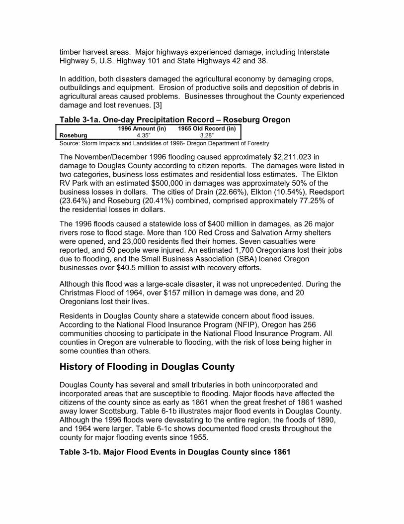
timber harvest areas. Major highways experienced damage, including Interstate Highway 5, U.S. Highway 101 and State Highways 42 and 38. In addition, both disasters damaged the agricultural economy by damaging crops, outbuildings and equipment. Erosion of productive soils and deposition of debris in agricultural areas caused problems. Businesses throughout the County experienced damage and lost revenues. [3]
Table 3-1a. One-day Precipitation Record – Roseburg Oregon Roseburg
1996 Amount (in) 4.35”
1965 Old Record (in) 3.28”
Source: Storm Impacts and Landslides of 1996- Oregon Department of Forestry The November/December 1996 flooding caused approximately $2,211.023 in damage to Douglas County according to citizen reports. The damages were listed in two categories, business loss estimates and residential loss estimates. The Elkton RV Park with an estimated $500,000 in damages was approximately 50% of the business losses in dollars. The cities of Drain (22.66%), Elkton (10.54%), Reedsport (23.64%) and Roseburg (20.41%) combined, comprised approximately 77.25% of the residential losses in dollars. The 1996 floods caused a statewide loss of $400 million in damages, as 26 major rivers rose to flood stage. More than 100 Red Cross and Salvation Army shelters were opened, and 23,000 residents fled their homes. Seven casualties were reported, and 50 people were injured. An estimated 1,700 Oregonians lost their jobs due to flooding, and the Small Business Association (SBA) loaned Oregon businesses over $40.5 million to assist with recovery efforts. Although this flood was a large-scale disaster, it was not unprecedented. During the Christmas Flood of 1964, over $157 million in damage was done, and 20 Oregonians lost their lives. Residents in Douglas County share a statewide concern about flood issues. According to the National Flood Insurance Program (NFIP), Oregon has 256 communities choosing to participate in the National Flood Insurance Program. All counties in Oregon are vulnerable to flooding, with the risk of loss being higher in some counties than others.
History of Flooding in Douglas County Douglas County has several and small tributaries in both unincorporated and incorporated areas that are susceptible to flooding. Major floods have affected the citizens of the county since as early as 1861 when the great freshet of 1861 washed away lower Scottsburg. Table 6-1b illustrates major flood events in Douglas County. Although the 1996 floods were devastating to the entire region, the floods of 1890, and 1964 were larger. Table 6-1c shows documented flood crests throughout the county for major flooding events since 1955.
Table 3-1b. Major Flood Events in Douglas County since 1861
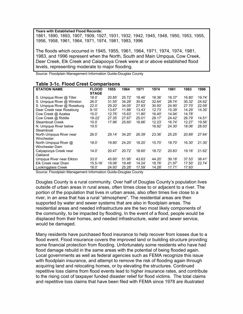
Years with Established Flood Records: 1861, 1890, 1893, 1907, 1909, 1927, 1931, 1932, 1942, 1945, 1948, 1950, 1953, 1955, 1956, 1958, 1961, 1964, 1971, 1974, 1981, 1983, 1996 The floods which occurred in 1945, 1955, 1961, 1964, 1971, 1974, 1974, 1981, 1983, and 1996 represent when the North, South and Main Umpqua, Cow Creek, Deer Creek, Elk Creek and Calapooya Creek were at or above established flood levels, representing moderate to major flooding. Source: Floodplain Management Information Guide-Douglas County Table 3-1c. Flood Crest Comparisons STATION NAME FLOOD
STAGE 1955 1964 1971 1974 1981 1983 1996
S. Umpqua River @ Tiller 18.0’ 20.85’ 25.72’ 18.46’ 18.36’ 18.37’ 16.80’ 19.74’S. Umpqua River @ Winston 26.0’ 31.55’ 34.28’ 30.62’ 32.64’ 28.74’ 30.32’ 24.62’S. Umpqua River @ Roseburg 22.0’ 29.20’ 34.05’ 27.83’ 30.50’ 24.90’ 27.70’ 22.09’Deer Creek near Roseburg 9-10’ 13.67’ 11.88’ 13.43’ 12.73’ 15.39’ 14.29’ 14.35’Cow Creek @ Azalea 10.0’ 12.76’ 15.63’ 11.80’ 16.40’ 14.94’ 14.78’ Cow Creek @ Riddle 18-22’ 27.35’ 27.67’ 25.01’ 28.17’ 24.42’ 26.79’ 14.51’Steamboat Creek 10.0’ 17.96’ 25.60’ 16.66’ 12.23’ 16.74’ 12.27’ 19.56’N. Umpqua River below Steamboat
19.5’ 16.92’ 24.30’ 18.06’ 28.93’
North Umpqua River near Winchester
26.0’ 29.14’ 34.20’ 26.39’ 23.36’ 25.25’ 20.89’ 27.64’
North Umpqua River @ Winchester Dam
18.0’ 19.80’ 24.20’ 18.20’ 15.70’ 18.70’ 16.30’ 21.30’
Calyapooya Creek near Oakland
14.0’ 20.47’ 20.72’ 18.60’ 18.72’ 20.83’ 19.16’ 21.62’
Umpqua River near Elkton 33.0’ 45.60’ 51.95’ 43.63’ 44.20’ 39.18’ 37.53’ 38.41’Elk Creek near Drain 15.5-16’ 19.06’ 19.48’ 14.24’ 18.76’ 21.97’ 17.50’ 22.74’Lookingglass Creek 18.0’ 24.93’ 25.28’ 17.59’ 14.28’ 17.71’ 17.93’ Source: Floodplain Management Information Guide-Douglas County Douglas County is a rural community. Over half of Douglas County’s population lives outside of urban areas in rural areas, often times close to or adjacent to a river. The portion of the population that lives in urban areas, also often times live close to a river, in an area that has a rural “atmosphere”. The residential areas are then supported by water and sewer systems that are also in floodplain areas. The residential areas and needed infrastructure are the two most likely components of the community, to be impacted by flooding. In the event of a flood, people would be displaced from their homes, and needed infrastructure, water and sewer service, would be damaged. Many residents have purchased flood insurance to help recover from losses due to a flood event. Flood insurance covers the improved land or building structure providing some financial protection from flooding. Unfortunately some residents who have had flood damage rebuild in the same areas with the potential of being flooded again. Local governments as well as federal agencies such as FEMA recognize this issue with floodplain insurance, and attempt to remove the risk of flooding again through acquiring land and relocating homes, or by elevating the structures. Continued repetitive loss claims from flood events lead to higher insurance rates, and contribute to the rising cost of taxpayer funded disaster relief for flood victims. The total claims and repetitive loss claims that have been filed with FEMA since 1978 are illustrated
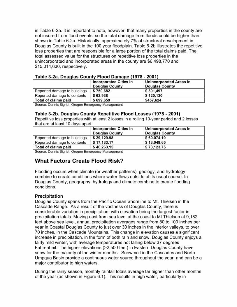
in Table 6-2a. It is important to note, however, that many properties in the county are not insured from flood events, so the total damage from floods could be higher than shown in Table 6-2a. Historically, approximately 7% of structural development in Douglas County is built in the 100 year floodplain. Table 6-2b illustrates the repetitive loss properties that are responsible for a large portion of the total claims paid. The total assessed value for the structures on repetitive loss properties in the unincorporated and incorporated areas in the county are $6,498,770 and $15,014,630, respectively. Table 3-2a. Douglas County Flood Damage (1978 - 2001) Incorporated Cities in
Douglas County Unincorporated Areas in Douglas County
Reported damage to buildings $ 750,682 $ 391,497 Reported damage to contents $ 62,938 $ 120,130 Total of claims paid $ 699,659 $457,624 Source: Dennis Sigrist, Oregon Emergency Management Table 3-2b. Douglas County Repetitive Flood Losses (1978 - 2001) Repetitive loss properties with at least 2 losses in a rolling 10-year period and 2 losses that are at least 10 days apart. Incorporated Cities in
Douglas County Unincorporated Areas in Douglas County
Reported damage to buildings $ 29,129.98 $ 60,074.10 Reported damage to contents $ 17,133.17 $ 13,049.65 Total of claims paid $ 46,263.15 $ 73,123.75 Source: Dennis Sigrist, Oregon Emergency Management
What Factors Create Flood Risk? Flooding occurs when climate (or weather patterns), geology, and hydrology combine to create conditions where water flows outside of its usual course. In Douglas County, geography, hydrology and climate combine to create flooding conditions. Precipitation Douglas County spans from the Pacific Ocean Shoreline to Mt. Thielsen in the Cascade Range. As a result of the vastness of Douglas County, there is considerable variation in precipitation, with elevation being the largest factor in precipitation totals. Moving east from sea level at the coast to Mt Thielsen at 9,182 feet above sea level, annual precipitation averages range from 80 to 100 inches per year in Coastal Douglas County to just over 30 inches in the interior valleys, to over 70 inches, in the Cascade Mountains. This change in elevation causes a significant increase in precipitation, in the form of both rain and snow. Douglas County enjoys a fairly mild winter, with average temperatures not falling below 37 degrees Fahrenheit. The higher elevations (>2,500 feet) in Eastern Douglas County have snow for the majority of the winter months. Snowmelt in the Cascades and North Umpqua Basin provide a continuous water source throughout the year, and can be a major contributor to high waters. During the rainy season, monthly rainfall totals average far higher than other months of the year (as shown in Figure 6.1). This results in high water, particularly in
December and January. High water is usually the result of heavy rains of two-day to five-day durations augmented by snowmelt at a time when the soil is near saturation from previous rains.
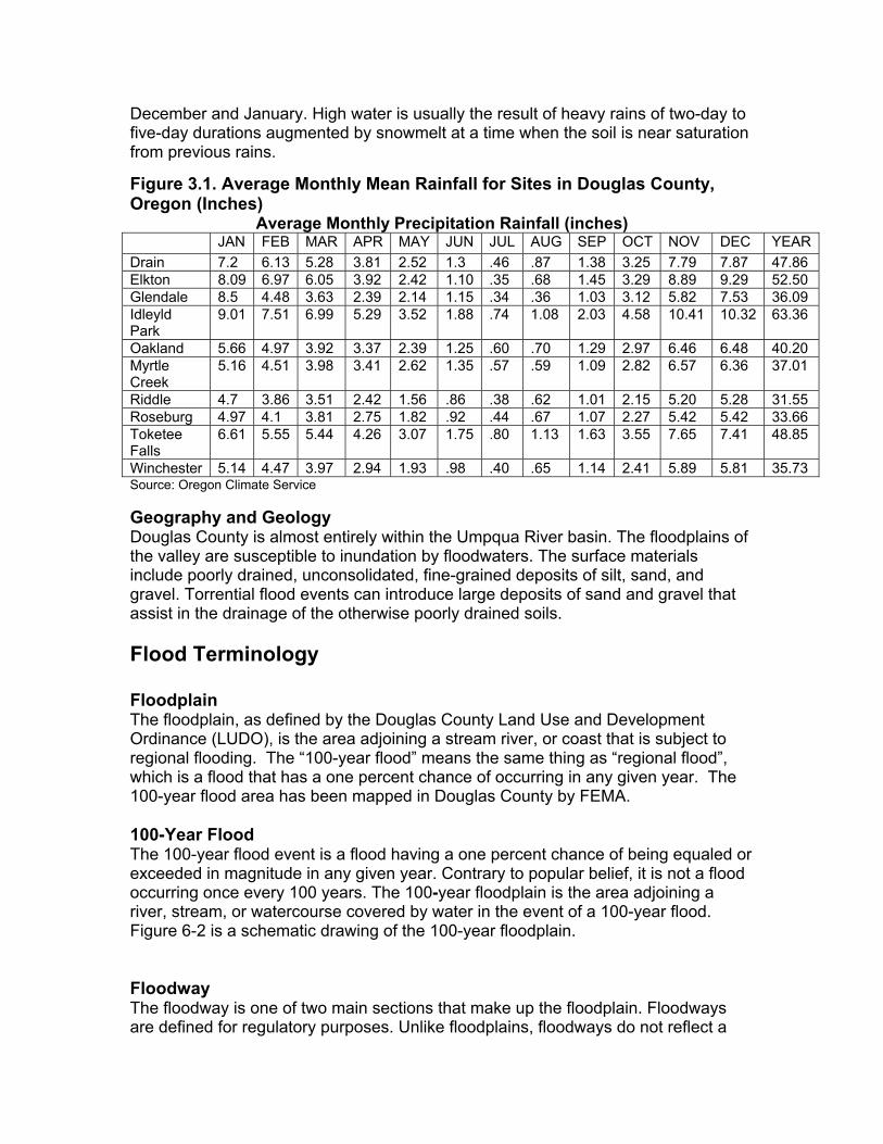
Figure 3.1. Average Monthly Mean Rainfall for Sites in Douglas County, Oregon (Inches)
Average Monthly Precipitation Rainfall (inches) JAN FEB MAR APR MAY JUN JUL AUG SEP OCT NOV DEC YEARDrain 7.2 6.13 5.28 3.81 2.52 1.3 .46 .87 1.38 3.25 7.79 7.87 47.86 Elkton 8.09 6.97 6.05 3.92 2.42 1.10 .35 .68 1.45 3.29 8.89 9.29 52.50 Glendale 8.5 4.48 3.63 2.39 2.14 1.15 .34 .36 1.03 3.12 5.82 7.53 36.09 Idleyld Park
9.01 7.51 6.99 5.29 3.52 1.88 .74 1.08 2.03 4.58 10.41 10.32 63.36
Oakland 5.66 4.97 3.92 3.37 2.39 1.25 .60 .70 1.29 2.97 6.46 6.48 40.20 Myrtle Creek
5.16 4.51 3.98 3.41 2.62 1.35 .57 .59 1.09 2.82 6.57 6.36 37.01
Riddle 4.7 3.86 3.51 2.42 1.56 .86 .38 .62 1.01 2.15 5.20 5.28 31.55 Roseburg 4.97 4.1 3.81 2.75 1.82 .92 .44 .67 1.07 2.27 5.42 5.42 33.66 Toketee Falls
6.61 5.55 5.44 4.26 3.07 1.75 .80 1.13 1.63 3.55 7.65 7.41 48.85
Winchester 5.14 4.47 3.97 2.94 1.93 .98 .40 .65 1.14 2.41 5.89 5.81 35.73 Source: Oregon Climate Service Geography and Geology Douglas County is almost entirely within the Umpqua River basin. The floodplains of the valley are susceptible to inundation by floodwaters. The surface materials include poorly drained, unconsolidated, fine-grained deposits of silt, sand, and gravel. Torrential flood events can introduce large deposits of sand and gravel that assist in the drainage of the otherwise poorly drained soils. Flood Terminology Floodplain The floodplain, as defined by the Douglas County Land Use and Development Ordinance (LUDO), is the area adjoining a stream river, or coast that is subject to regional flooding. The “100-year flood” means the same thing as “regional flood”, which is a flood that has a one percent chance of occurring in any given year. The 100-year flood area has been mapped in Douglas County by FEMA. 100-Year Flood The 100-year flood event is a flood having a one percent chance of being equaled or exceeded in magnitude in any given year. Contrary to popular belief, it is not a flood occurring once every 100 years. The 100-year floodplain is the area adjoining a river, stream, or watercourse covered by water in the event of a 100-year flood. Figure 6-2 is a schematic drawing of the 100-year floodplain. Floodway The floodway is one of two main sections that make up the floodplain. Floodways are defined for regulatory purposes. Unlike floodplains, floodways do not reflect a
recognizable geologic feature. For NFIP purposes, floodways are defined as the channel of a river or stream, and the overbank areas adjacent to the channel. The floodway carries the bulk of the floodwater downstream and is usually the area where water velocities and forces are the greatest. NFIP regulations require that the floodways be kept open and free from development or other structures that would increase the floodway water height Douglas County regulations require development in the floodway to be certified by an Oregon licensed engineer. The licensed engineer must include a statement that no increase in flood levels (caused by the proposed structure) shall occur during a regional flood. The NFIP floodway definition is “the channel of a river or other watercourse and adjacent land areas that must be reserved in order to discharge the base flood without cumulatively increasing the water surface elevation more than one foot. Floodways are not mapped for all rivers and streams but are generally mapped in developed areas. Flood Fringe Areas that may be flooded with standing water are said to be in the floodway fringe. The floodway fringe is located within the floodplain boundary. Development For floodplain ordinance purposes, development is broadly defined by the Douglas County Land Use Development Ordinance to mean “any manmade change to improved or unimproved real estate, including but not limited to the construction, alteration, installation or use of buildings, division of land, creation of private or public streets, mining, excavation, farming, forest use, open storage of materials, or any activity specifically regulated by the provisions of this ordinance.” The definition of development for floodplain purposes is generally broader and includes more activities than the definition of development used in other sections of local land use ordinances. Base Flood Elevation (BFE) The term “Base Flood Elevation” refers to the elevation (normally measured in feet above sea level) that the base flood is expected to reach. Base flood elevations can be set at levels other than the 100-year flood, however, the National Flood Insurance Program regulations focus on development in the 100-year floodplain.
Characteristics of Flooding Two types of flooding primarily affect Douglas County: riverine flooding and urban flooding (see descriptions below). In addition, any low-lying area has the potential to flood. The flooding of developed areas may occur when the amount of water generated from rainfall and runoff exceeds a storm water system's (ditch or sewer) capability to remove it.13
Riverine Flooding Riverine flooding is the overbank flooding of rivers and streams. The natural process of riverine flooding adds sediment and nutrients to fertile floodplain areas. Flooding in large river systems typically results from large-scale weather systems that generate prolonged rainfall over a wide geographic area, causing flooding in hundreds of smaller streams, which then drain into the major rivers. Shallow area flooding is a special type of riverine flooding. FEMA defines shallow flood hazards as
areas that are inundated by the 100- year flood with flood depths of only one to three feet. These areas are generally flooded by low velocity sheet flows of water. Urban Flooding As land is converted from fields or woodlands to roads and parking lots, it loses its ability to absorb rainfall. Urbanization of a watershed changes the hydrologic systems of the basin. Heavy rainfall collects and flows faster on impervious concrete and asphalt surfaces. The water moves from the clouds, to the ground, and into streams at a much faster rate in urban areas. Adding these elements to the hydrological systems can result in floodwaters that rise very rapidly and peak with violent force. Most of Douglas County is rural, with a low percentage of incorporated land. However much of the population lives within cities or rural unincorporated areas with a high concentration of impermeable surfaces that either collects water, or concentrate the flow of water. During periods of urban flooding, streets carry water to culverts. Culverts and storm drains sometimes back up with vegetative debris causing localized flooding. Dam Failure Flooding Loss of life and damage to structures, roads, utilities and crops may result from a dam failure. Economic losses can also result from a lowered tax base and lack of utility profits. These effects could possibly accompany the failure of one of the major dams in Douglas County. Six major water impoundment dams have been developed in Douglas County to serve flood control and water needs. Because dam failure can have severe consequences, FEMA requires that all dam owners develop Emergency Action Plans (EAP) for warning, evacuation, and post-flood actions. Although there may be coordination with county officials in the development of the EAP, the responsibility for developing potential flood inundation maps and facilitation of emergency response is the responsibility of the dam owner. For more detailed information regarding dam failure flooding, and potential flood inundation zones for a particular dam in the county, please refer to the Douglas County Emergency Action Plan, available at the Douglas County Sheriffs Department.
What is the Effect of Development on Floods? When structures or fill are placed in the floodway or floodplain, water is displaced. Development raises the river levels by forcing the river to compensate for the flow space obstructed by the inserted structures and/or fill. When structures or materials are added to the floodway or floodplain and no fill is removed to compensate, serious problems can arise. Floodwaters may be forced away from historic floodplain areas. As a result, other existing floodplain areas may experience floodwaters that rise above historic levels. Local governments must require engineer certification to ensure that proposed developments would not adversely affect the flood carrying capacity of the Special Flood Hazard Area (SFHA). Displacement of only a few inches of water can mean the difference between no structural damage occurring in a given flood event, and the inundation of many homes, businesses, and other facilities. Careful attention
should be given to development that occurs within the floodway to ensure that structures are prepared to with stand regional flood events. In highly urbanized areas, increased paving can lead to an increase in volume and velocity of runoff after a rainfall event, exacerbating the potential flood hazards. Care should be taken in the development and implementation of storm water management systems to ensure that these runoff waters are dealt with effectively.
How Are Flood-Prone Areas Identified? Flood maps and Flood Insurance Studies (FIS) are often used to identify flood-prone areas. The NFIP was established in 1968 as a means of providing low-cost flood insurance to the nation’s flood-prone communities. The NFIP also reduces flood losses through regulations that focus on building codes and “sound floodplain management.” In Douglas County, the NFIP and related building code regulations went into effect on March 1, 1978. NFIP regulations (44 Code of Federal Regulations [CFR] Chapter 1, Section 60.3) require that all new construction in floodplains must be elevated at or above base flood level. The Oregon Building Code requires new construction to be elevated to one foot above the base flood elevation. Communities participating in the NFIP may adopt regulations that are more stringent than those contained in 44 CFR 60.3, but not less stringent. Flood Insurance Rate Maps (FIRM) and Flood Insurance Studies (FIS) Floodplain maps are the basis for implementing floodplain regulations and for delineating flood insurance purchase requirements. A Flood Insurance Rate Map (FIRM) is the official map produced by FEMA, which delineates SFHA in communities where NFIP regulations apply. FIRMs are also used by insurance agents and mortgage lenders to determine if flood insurance is required and what insurance rates should apply. Water surface elevations are combined with topographic data to develop FIRMs. FIRMs illustrate areas that would be inundated during a 100-year flood, floodway areas, and elevations marking the 100-year-flood level. In some cases they also include base flood elevations (BFEs) and areas located within the 500-year floodplain. Flood Insurance Studies and FIRMs produced for the NFIP provide assessments of the probability of flooding at a given location. FEMA conducted many Flood Insurance Studies in the late 1970s and early 1980s. These studies and maps represent flood risk at the point in time when FEMA completed the studies. However, it is important to note that not all 100-year or 500-year floodplains have been mapped by FEMA. FEMA flood maps are not entirely accurate. Flood studies and maps represent flood risk at the point in time when FEMA completed the studies, and do not incorporate planning for floodplain changes in the future due to new development. Most FIRM maps for Douglas County were completed in 1978.
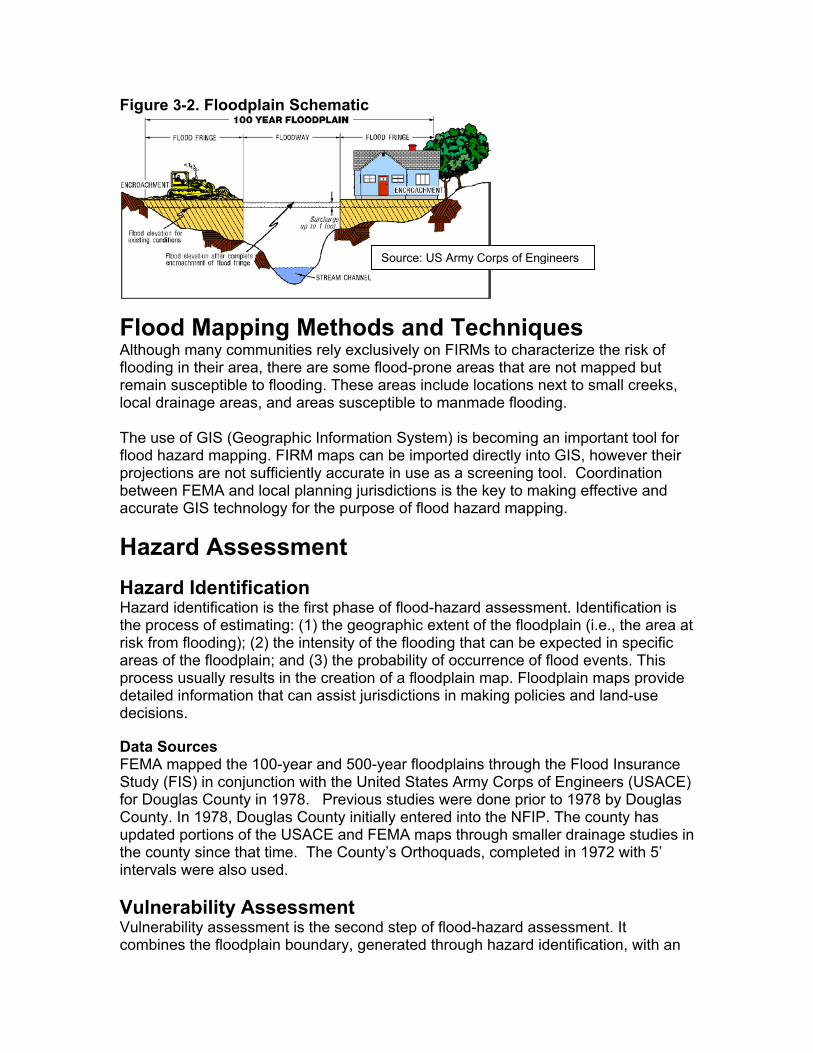
Figure 3-2. Floodplain Schematic
Flood Mapping MethodAlthough many communities rely exclflooding in their area, there are some remain susceptible to flooding. Theselocal drainage areas, and areas susce The use of GIS (Geographic Informatiflood hazard mapping. FIRM maps caprojections are not sufficiently accuratbetween FEMA and local planning juraccurate GIS technology for the purpo
Hazard Assessment Hazard Identification Hazard identification is the first phasethe process of estimating: (1) the georisk from flooding); (2) the intensity of areas of the floodplain; and (3) the proprocess usually results in the creationdetailed information that can assist jurdecisions. Data Sources FEMA mapped the 100-year and 500-Study (FIS) in conjunction with the Unfor Douglas County in 1978. PreviouCounty. In 1978, Douglas County initiupdated portions of the USACE and Fthe county since that time. The Counintervals were also used. Vulnerability Assessment Vulnerability assessment is the seconcombines the floodplain boundary, ge
Source: US Army Corps of Engineers
s and Techniques usively on FIRMs to characterize the risk of flood-prone areas that are not mapped but areas include locations next to small creeks, ptible to manmade flooding.
on System) is becoming an important tool for n be imported directly into GIS, however their e in use as a screening tool. Coordination isdictions is the key to making effective and se of flood hazard mapping.
of flood-hazard assessment. Identification is graphic extent of the floodplain (i.e., the area at the flooding that can be expected in specific bability of occurrence of flood events. This of a floodplain map. Floodplain maps provide isdictions in making policies and land-use
year floodplains through the Flood Insurance ited States Army Corps of Engineers (USACE) s studies were done prior to 1978 by Douglas ally entered into the NFIP. The county has EMA maps through smaller drainage studies in ty’s Orthoquads, completed in 1972 with 5’
d step of flood-hazard assessment. It nerated through hazard identification, with an
inventory of the property within the floodplain. Understanding the population and property exposed to natural hazards will assist in reducing risk and preventing loss from future events. Because site-specific inventory data and inundation levels given for a particular flood event (10-year, 25-year, 50-year, 100-year, 500-year) are not readily available, calculating a community’s vulnerability to flood events is not straightforward. The amount of property in the floodplain, as well as the type and value of structures on those properties, should be calculated to provide a working estimate for potential flood losses. Risk Analysis Risk analysis is the third and most advanced phase of a hazard assessment. It builds upon the hazard identification and vulnerability assessment. A flood risk analysis for Douglas County should include two components: (1) the life and value of property that may incur losses from a flood event (defined through the vulnerability assessment); and (2) the number and type of flood events expected to occur over time. Within the broad components of a risk analysis, it is possible to predict the severity of damage from a range of events. Flow velocity models can assist in predicting the amount of damage expected from different magnitudes of flood events. The data used to develop these models is based on hydrological analysis of landscape features. Changes in the landscape, often associated with human development, can alter the flow velocity and the severity of damage that can be expected from a flood event. Using GIS technology, aerial photographs and flow velocity models, it is possible to map the damage that can be expected from flood events over time. It is also possible to pinpoint the effects of certain flood events on individual properties. At the time of publication of this plan, data was insufficient to conduct a risk analysis for flood events in Douglas County. This plan includes recommendations for building partnerships that will support the development of a flood risk analysis in Douglas County.
Community Flood Issues What is Susceptible to Damage During a Flood Event? The largest impact on communities from flood events is the loss of life and property. Property loss from floods strikes both private and public property. Public sector impacts (e.g., impacts to water and sewer systems, roads, etc.) statewide resulted in approximately two-thirds of the damage from the 1996 flood events.
Property Loss Resulting from Flooding Events The type of property damage caused by flood events depends on the depth and velocity of the floodwaters. Faster moving floodwaters can wash buildings off their foundations and sweep cars downstream. Pipelines, bridges, and other infrastructure can be damaged when high waters combine with flood debris. Extensive damage can be caused by basement flooding and landslide damage related to soil saturation
from flood events. Seepage into basements or daylight basements is common during flood events, not only in or near floodplains, but also on hillsides and other areas that are far removed from floodplains. Most flood damage is caused by water saturating materials susceptible to loss (e.g., wood, insulation, wallboard, fabric, furnishings, floor coverings, and appliances). Homes Homes in frequently flooded areas can also suffer damage to septic systems and drain fields. Homes in rural floodplain areas often depend on private sewage treatment systems, and inundation of these systems may result in leakage of wastewater into surrounding areas. In many cases, flood damage to homes renders them unlivable. Manufactured Homes Statewide, the 1996 floods destroyed 156 housing units. Of those units, 61% were mobile homes and trailers. Many older manufactured home parks are located in floodplain areas. Manufactured homes have a lower level of structural stability than stick-built homes, and must be anchored to provide additional structural stability during flood events. Because of confusion in the late 1980s resulting from multiple changes in NFIP regulations, there are some communities that do not actively enforce anchoring requirements. Lack of enforcement of manufactured home construction standards in floodplains can contribute to severe damages from flood events.
Business/Industry Flood events impact businesses by damaging property and by interrupting business. Flood events can cut off customer access to a business as well as close a business for repairs. A quick response to the needs of businesses affected by flood events can help a community maintain economic vitality in the face of flood damage. Responses to business damages can include funding to assist owners in elevating or relocating flood-prone business structures.
Public Infrastructure Publicly owned facilities are a key component of daily life for all citizens of the county. Damage to public water and sewer systems, transportation networks, flood control facilities, emergency facilities, and offices can hinder the ability of the government to deliver services. Government can take action to reduce risk to public infrastructure from flood events, as well as craft public policy that reduces risk to private property from flood events. There are a variety of drinking water, surface water, and wastewater service providers throughout the county. During flooding events, the infrastructure that supports the water service providers in the county can be damaged.
Buildings In the wake of the 1996 flood events, damage to public buildings statewide represented 34% of total public losses. Of particular importance during flood events are facilities located in flood hazard areas that are critical to government response
and recovery activities. Roads During natural hazard events, or any type of emergency or disaster, dependable road connections are critical for providing emergency services. Roads systems in Douglas County are maintained by multiple jurisdictions. Federal, state, county, and city governments all have a stake in protecting roads from flood damage. Road networks often traverse floodplain and floodway areas. Transportation agencies responsible for road maintenance are typically aware of roads at risk from flooding. Bridges Bridges are key points of concern during flood events because they are important links in road networks, watercourse crossings, and they can be obstructions in watercourses, inhibiting the flow of water during flood events. The bridges in Douglas County are state, county, city, or privately owned. A state-designated inspector must inspect all state, county, and city bridges every two years, but private bridges are not inspected, and can be very dangerous. The inspections are rigorous, looking at everything from seismic capability to erosion and scour. Upon inspection, the bridges are subject to a sufficiency score. This score uses a scale of 1 to 100 with 1 being the worst rating. Then the bridges are ranked throughout the state according to their score. The state then prioritizes the bridge repair according to each score. If the bridge receives a sufficiency score of less than 50, it is on the list for upgrading and rehabilitation. If it scores over 50, it is not included on the list. The smaller, more economically feasible repairs to county bridges are the responsibility of Douglas County Public Works Department. The larger projects require funding through the Highway Bridge Replacement and Rehabilitation Program (HBRR). HBRR provides 80% of funding, and the county is responsible for 20%.
Storm Water Systems Local drainage problems are common throughout the region. Several communities have drainage master plans, and local public works staff is often aware of local drainage threats. The problems are often present where open ditches enter culverts or go underground into storm sewers. In addition, high water tables in some areas can mean wet crawl spaces, yards, and basements after storms because the accumulated water does not drain quickly into a stream or storm sewer. Filled ditches and swales near buildings can inhibit or prevent the flow of water and compound these problems. Inadequate maintenance, especially following leaf accumulation in the fall, can also contribute to the flood hazard in urban areas.
Water Quality Major water quality issues occur in those streams that have low flows and pass through areas where human activities are concentrated. In conjunction with seasonal low flow problems, stream quality is degraded by high water temperatures that are common in the Umpqua River system and tributaries from June through October. Existing Flood Mitigation Activities Flood mitigation activities listed here include current mitigation programs and
activities that are being implemented by Douglas County Departments, agencies or organizations. Douglas County Codes Article 30 of the Douglas County Land Use and Development Ordinance describes possible development in the floodplain but, before the Douglas County Planning Department can give clearance for development, the applicant must provide the department with a “Certificate Of Elevation” prepared by an Oregon licensed surveyor or engineer. The Certificate of Elevation will determine the “minimum required floor height above ground” for the proposed structure. Under Douglas County requirements, the lowest habitable floor of a new dwelling is required to be one foot above the 100-year floodplain height. If the building site elevation is 18” or more below flood height, or if the site is designated as “high hazard” or is in the floodway, the foundation plans must be prepared by an Oregon Licensed Engineer or Architect. If the site is in the floodway, the certificate must also include a statement from an Oregon licensed engineer stating that any increase in flood levels (caused by the proposed structure) shall not result in any increase in flood levels during the occurrence of a regional flood. Fill in the floodway (placement of sand, soil, sediment or other material to raise the elevation of the land requires the same documentation as does structural development in the floodway. Once construction of the foundation and floor is complete, the surveyor/engineer will inspect the structure. If the minimum floor height specification has been met, the surveyor/engineer will sign off the certification form, and submit it to the Douglas County Building Department. Accessory buildings such as garages, woodsheds, etc. require certification but do not necessarily require elevation. Agricultural buildings are subject to floodplain regulations if located in the floodplain. Flood proofing required in floodplain areas can be achieved by such methods as breakaway panels in the building, venting, or elevating the site to meet specifications. Community Rating System (CRS) In 1997, FEMA audited the Douglas County Planning Department floodplain program. The result of the audit was a recommendation from FEMA to the Community Rating System (CRS). The Community Rating System reviewed the recommendation, and then did an audit also. The result of the audits concluded that Douglas County’s Floodplain Program complied with the requirements of the National Flood Insurance Program in an exemplary manner. The result of the FEMA and CRS audits was a rating of Douglas County’s Floodplain Program by the CRS. The CRS rated Douglas County’s Floodplain Program an “8”, which resulted in a 10% reduction in the cost of flood insurance for residents of Douglas County. This 10% reduction translates into about $40,000.00 dollars annually in saved insurance premiums for residents of Douglas County. Following completion of this natural hazard mitigation plan, Douglas County will be audited again, and hopefully obtain
another 5 to 10% reduction. State of Oregon Floodplain and Floodway Removal/Fill Law The Oregon Removal/Fill Law, which is administered by the Oregon Division of State Lands (DSL), requires a permit for activities that would remove or fill 50 cubic yards or more of material in waters of the state (e.g., streams, lakes, wetlands). Natural Systems Maintaining and restoring natural systems help to mitigate the impact of flood events on the built environment. Flooding changes the natural environment and hydrology of an affected area. High water can be beneficial to the natural processes within a floodplain, and can benefit riparian areas. The best flood control techniques work to control water using the natural features such as wetlands that assist in water storage and bank stability. Riparian Areas Riparian areas are important transitional areas that link water and land ecosystems. Vegetation in riparian areas is dependent on stream processes, such as flooding, and often is composed of plants that require large amounts of water, such as willows and cottonwood trees. Healthy vegetation in riparian buffers can reduce streamside erosion Wastewater Management There are a variety of wastewater service providers in the county, ranging from cities to service districts that help to keep the waters of Douglas County clean and pure. Wetlands Many floodplain and stream-associated wetlands absorb and store storm water flows, which reduces flood velocities and stream bank erosion. Preserving these wetlands reduces flood damage and the need for expensive flood control devices such as levees. When the storms are over, many wetlands augment summer stream flows by slowly releasing the stored water back to the stream system. Wetlands are highly effective at removing nitrogen, phosphorous, heavy metals, and other pollutants from water. For this reason, artificial wetlands are often constructed for cleaning storm water runoff and for tertiary treatment of wastewater. Wetlands bordering streams and rivers and those that intercept runoff from fields and roads provide this valuable service free of charge. Wetland restoration projects have been initiated and completed by various organizations throughout the county. Many detention ponds are constructed wetlands. Community Issues Summary Douglas County works to mitigate problems regarding flooding through a proactive floodplain program. The Douglas County Planning Department administers Douglas County’s floodplain program, which is rated an “8” by the Community Rating System. Douglas County believes that displacement of people from their homes and damage to needed water and sewer facilities, are mitigation priorities for flood events in
Douglas County.
Flood Mitigation Goals GOAL A Protect structures in the floodplain from flooding. GOAL B If a structure becomes a repetitive loss structure, inform owner of possible mitigation funding options. GOAL C If a structure becomes a repetitive loss structure, and a cost benefit analysis reveals the repetitive loss has a substantial cost, encourage owner to use mitigation funding options.
Flood Mitigation Action Items The flood mitigation action items provide direction on specific activities that organizations and residents in Douglas County can undertake to reduce risk and prevent loss from flood events. Each action item is followed by ideas for implementation, which can be used by the steering committee and local decision makers in pursuing strategies for implementation. ACTION ITEM 1 – Require elevation certification forms prior to planning approval, per floodplain regulations, for structural development within 100-year flood plain. Ideas for Implementation Douglas County’s Floodplain Management Program. Coordinating Organization: Douglas County Planning Department Timeline: Continue. Plan Goals Addressed: GOAL A. ACTION ITEM 2 – Require engineer “no rise” certification prior to planning approval, per floodplain regulations, for structural development within the federal floodway. Ideas for Implementation Douglas County’s Floodplain Management Program. Coordinating Organization: Douglas County Planning Department Timeline: Continue. Plan Goals Addressed: GOAL A. ACTION ITEM 3 – Increase Douglas County’s CRS rating through encouraging non-regulatory flood mitigation. Ideas for Implementation Request an audit by the CRS, following completion of the natural hazard mitigation plan. Discuss floodplain issues when clients have contact with the Douglas County Planning Department. Discuss floodplain issues through outreach opportunities.
Coordinating Organization: Douglas County Planning Department. Timeline: Continue. Plan Goals Addressed: GOAL A. ACTION ITEM 4 – Identify opportunities to upgrade Federal Insurance Rate Map. Ideas for Implementation Douglas County’s Floodplain Management Program. Coordinating Organization: Douglas County Planning Department Timeline: Continue. Plan Goals Addressed: GOAL A. ACTION ITEM 4 – Identify opportunities to upgrade Douglas County Planning Department’s GIS system for floodplain mapping. Ideas for Implementation Douglas County’s Floodplain Management Program. Coordinating Organization: Douglas County Planning Department Timeline: Continue. Plan Goals Addressed: GOAL A. ACTION ITEM 5 – Distribute information regarding flooding to the general public efficiently. Ideas for Implementation Douglas County Emergency Management Outreach Program. Coordinating Organization: Douglas County Emergency Management. Timeline: Continue. Plan Goals Addressed: GOAL A. ACTION ITEM 6 – Identify surface water drainage obstructions, and seek funding for culvert drainage mitigation projects, through FEMA’s Hazard Mitigation Grant Program. Ideas for Implementation Douglas County Emergency Management Outreach Program. Coordinating Organization: Douglas County Emergency Management. Timeline: Continue. Plan Goals Addressed: GOAL A, B, and C. ACTION ITEM 7 – Explore funding for repetitive loss property mitigation projects, through FEMA’s Hazard Mitigation Grant Program. Ideas for Implementation Douglas County Emergency Management Outreach Program. Coordinating Organization: Douglas County Emergency Management. Timeline: Continue. Plan Goals Addressed: GOAL B and C. Flood Endnotes • Beckham, Steven Dow; Land of the Umpqua; A History of Douglas County Oregon (1986) • Douglas County Planning Department, A Place Called Douglas County (1990) • Flood Hazard Mitigation Plan - Douglas County, Douglas County Planning Department & Umpqua Regional Council of Governments
• Flood Insurance Payments Summary, Oregon Emergency Management • Douglas County Planning Department Comprehensive Plan