Embed Size (px)
Citation preview
SECTION 3.0 Project Description

Perris Downtown Specific Plan Environmental Impact Report
Public Review Draft EIR Project Description June 2011 3-1
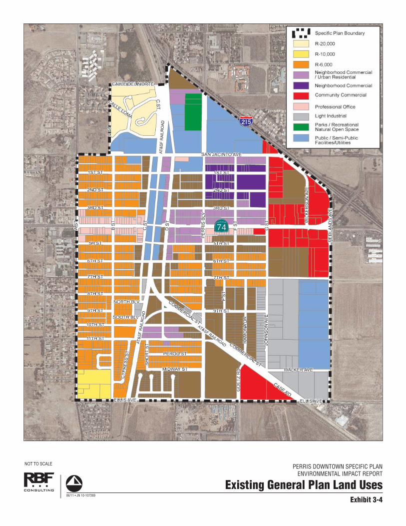
3.0 PROJECT DESCRIPTION 3.1 PROJECT LOCATION AND SETTING PROJECT LOCATION The proposed Perris Downtown Specific Plan (DTSP) project (project) is located in the City of Perris, California. The City of Perris is located in Riverside County along Interstate 215 (I-215), southeast of the City of Riverside; refer to Exhibit 3-1, Regional Vicinity. Downtown Perris is bounded by I-215 on the north, Ellis Avenue on the south, Redlands Avenue on the east, and A Street on the west; refer to Exhibit 3-2, Project Location and Exhibit 3-3, Project Aerial. PROJECT SETTING (EXISTING CONDITIONS) The Perris DTSP area encompasses approximately 730 acres and represents the original 1886 townsite along the railroad. The DTSP area consists of commercial uses and professional offices along D Street and 4th Street, with residential uses surrounding the commercial/office core. Residential land uses consist of a mix of single- and multiple-family dwelling units. Light industrial uses are located within the southeast portion of the DTSP area. The DTSP area also contains several prominent uses including the Civic Center (i.e., City Hall, Senior Center, and Library), Metrolink Station (to begin operating in 2013), Train Depot, Southern Hotel, and Perris Valley Museum. Several buildings within the Downtown have recently undergone or are currently undergoing façade improvements through the City’s Façade Improvement Program. Table 3-1, Summary of Existing Uses, identifies existing development within the Downtown. As indicated in Table 3-1, the Perris DTSP area contains approximately 1,345,356 square feet (s.f.) of non-residential uses (commercial/office, public facility, and light industrial) and 1,582 dwelling units. Additionally, approximately 165.2 acres within the DTSP area are currently vacant. Exhibit 3-4, Existing General Plan Land Uses, illustrates the DTSP’s existing General Plan land use designations. Circulation within the DTSP area is based on a traditional grid system. The main arterial streets used to access the Downtown are 4th Street (State Route 74 (SR-74)) and D Street. A portion of D Street has been improved with streetscape enhancements including streetlights, paving, benches, street trees, and public art. Land uses within the surrounding area include the I-215 Freeway, which forms the north/northeast boundary of the project area, residential and school uses to the west and northwest, industrial uses and Perris Valley Airport to the south, and commercial uses and vacant land (a majority of which is designated as New Perris Specific Plan) to the east.

S A L T O NS E A
PAC
I FI C
OC
EA
N
USMCCamp Pendleton
S A N B E R N A R D I N OC O U N T Y
R I V E R S I D EC O U N T Y
O R A N G EC O U N T Y
S A N D I E G OC O U N T Y
I M P E R I A LC O U N T Y
10
1030
30 173
247
247
18
18
18
62
62
18
18 330
138
38
215
215
15
15
10
10
60
60
66
2
30
91
111243
371
79
79
74
74
74 86
15
8
8
5
5
805
515
76
76
78
7878
86
94
52
56
125
195111
86S
79
79
79
67
395AppleValley
Victorville
HesperiaLucerneValley
Big BearLake
Yucaipa
Banning
PalmSprings
IdyllwildPalm
Desert
LaQuinta
Indio
JulianRamona
SanDiego
MiraMesa
Santee
Alpine
Poway
Coachella
DesertHot Springs
YuccaValley
TwentyninePalms
CathedralCity
Hemet
MorenoValley
Vista
Escondido
Encinitas
SunCity
PERRISCorona
Norco
RanchoCucamonga
Riverside
Ontario
Temecula
PineValley Ocotillo
BorregoSprings
WarnerSprings
Mecca
RanchoMirage
Anza
LakeArrowhead
IndianWells
SantaYsabel
Murrieta
LakeElsinore
SanClemente
Oceanside
Carlsbad
San JuanCapistrano
La Jolla
Del Mar
SanBernardino
RialtoLomaLinda
- Project Site
Rialto
PERRIS DOWNTOWN SPECIFIC PLANENVIRONMENTAL IMPACT REPORT
Exhibit 3-1
Regional Vicinity
NOT TO SCALE
06/11 • JN 10-107289

PERRIS DOWNTOWN SPECIFIC PLANENVIRONMENTAL IMPACT REPORT
Exhibit 3-2
Project Location
NOT TO SCALE
06/11 • JN 10-107289

PERRIS DOWNTOWN SPECIFIC PLANENVIRONMENTAL IMPACT REPORT
Exhibit 3-3
Project Aerial
NOT TO SCALE
06/11 • JN 10-107289
PERRIS DOWNTOWN SPECIFIC PLANENVIRONMENTAL IMPACT REPORT
Exhibit 3-4
Existing General Plan Land Uses
NOT TO SCALE
06/11 • JN 10-107289

Perris Downtown Specific Plan Environmental Impact Report
Public Review Draft EIR Project Description June 2011 3-6
Table 3-1 Summary of Existing Uses
Land Use Acreage Dwelling Units Square Feet
Single-Family Residential 146.5 795 Multiple-Family Residential 40.8 787 Commercial/Office 43.1 550,146 Public Facilities 85.7 450,725 Light Industrial 54.5 344,485 Vacant 165.2 Roads/Railroad 193.4
Total 729.2 1,582 1,345,356 3.2 BACKGROUND AND HISTORY 1993 PERRIS DOWNTOWN SPECIFIC PLAN The current Perris Downtown Specific Plan was adopted on March 6, 1993. Its concept was to provide for the revitalization and refocusing of the Downtown environment that would compliment and enhance the City’s existing development and amenities. The Perris DTSP is arranged into the following seven geographic areas referred to as “Districts”:
Gateway District (an Anchor District); Mercado District (an Anchor District); Downtown Promenade District; Town Center District; and Neighborhood Districts I, II, and III.
Each District defines zoning, architectural, and landscaping features. Additionally, the DTSP identified a Focus Area, which comprises the southern section of the Downtown Promenade District, adjacent to the Mercado District. This Focus Area defines in greater detail zoning, architectural, and landscape design guidelines. The Plan focuses on comprehensive land use designations ranging from residential uses, strategic commercial and retail sites, open space and parks, regional commuter rail facilities, public facilities, and a comprehensive vehicular circulation system.1 A specific level of development intensity was determined for each District, based on land use intensity, economics, and variable market conditions. As indicated in the 1993 DTSP Table III-1, Cumulative Development Intensity, the 1993 Specific Plan was forecast to involve approximately 3,089 dwelling units and 2.1 million square feet of non-residential development, including public facilities, commercial, professional office, and industrial, at buildout.
1 The Land Use Plans for the various Districts are illustrated in 1993 DTSP Figures III-2, III-11, III-14, III-17,
III-19, III-22, and III-23.

Perris Downtown Specific Plan Environmental Impact Report
Public Review Draft EIR Project Description June 2011 3-7
RELEVANT PLANS AND ACTIONS As the Downtown area changed, a number of other plans were developed, including the Downtown D Street Development Plan in 2004 and Compass Blueprint Perris Station Demonstration Project in 2006. Additionally, DTSP amendments were approved in 2005 (Specific Plan Amendment 05-0203) and 2007 (Specific Plan Amendment 07-0058). The following provides a brief overview of each plan/action:
Downtown D Street Development Plan. The 2004 Downtown D Street Development Plan is part of a long-range concept to revitalize and improve Downtown Perris. The Development Plan includes improvements along D Street to create a shopping and dining district that retains its historical charm while attracting residents and visitors. The Gateway Project consists of widening the intersection of D Street and San Jacinto Avenue to the ultimate General Plan street dimensions. Enhancements include decorative paving, lighting, landscaping, and new monument signs in front of City Hall, among other improvements within the area.
Specific Plan Amendment 05-0203. Specific Plan Amendment 05-0203 involved
amending the DTSP by adding a new land use district (i.e., Village Walk District) and applying the new district to approximately 25 acres located on the northeast corner of Perris Boulevard and Commercial Street, within DTSP Neighborhood III (Tentative Tract Map No. 33549 for a 127-lot residential subdivision). The Specific Plan Amendment also changed the subject site’s zoning from R-7 and Light Industrial to MFR-14/Planned Development (PD) Overlay Zone. Additionally, the Amendment established new development regulations and design guidelines governing the use of the land within the Village Walk District.
Compass Blueprint. In 2001, the Southern California Association of Governments
(SCAG) started a regional visioning process to develop a strategy for regional growth that would accommodate growth while providing for livability, mobility, prosperity, and sustainability. The Compass Blueprint strategy promotes a stronger link between region-wide transportation and land use planning and encourages creative, forward-thinking, and sustainable development solutions that fit local needs and support shared regional values. The implementation phase of Compass Blueprint involved a series of Compass Blueprint Demonstration Projects, including the Perris Station Demonstration Project, completed in November 2006. The demonstration project evaluated how the Perris Metrolink and bus station can be integrated with the Downtown and how the larger Downtown area can start to transition to a mixed-use environment with multi-modal transit services and a pedestrian urban design focus. The recommendation report provided a vision for the Perris Station area including urban design guidance and policy recommendations to amend the Downtown Specific Plan and address transit agency plans for parking and bus service.
Specific Plan Amendment 07-0058. Specific Plan Amendment 07-0058 involved
amending the DTSP by applying the Commercial Land Use with Residential Overlay (CLURO) zone to eight parcels (313-272-003, -004, -005, -006, -015, -016, -020, and -021) located east of “D” Street, between 10th and 11th Streets within Block 4 of the DTSP Mercado District. The parcels were zoned Commercial Neighborhood and R-14

Perris Downtown Specific Plan Environmental Impact Report
Public Review Draft EIR Project Description June 2011 3-8
Residential. The CLURO zoning allows for the mixing of commercial and residential land uses on these parcels.
Summary of Relevant Plans and Actions. In consideration of the relevant plans and
actions described above, the current DTSP is forecast to involve approximately 2,853 dwelling units and 2,378,607 square feet of non-residential development at buildout.
PERRIS DOWNTOWN SPECIFIC PLAN UPDATE With the changing community and future operation of the Metrolink Station, the City of Perris initiated an update to the 1993 Perris Downtown Specific Plan in 2008. The purpose of the Perris DTSP update was to create a cohesive plan for Downtown Perris that created an authentic identity and unique “sense of place,” while responding to changing community dynamics. The DTSP provides the framework for quality planning, and establishes development standards and design criteria to implement the community’s vision. The planning process for the Perris DTSP update included three distinct phases. Phase 1 involved a review of existing documents and information, background and data research, site reconnaissance and visual observations, and a two-day Strengths, Weaknesses, Opportunities, and Threats (SWOT) analysis of the Downtown businesses, including an intercept survey and an informational booth at the annual Rods to Rails. The initial phase of the planning process, which occurred from April to July 2008, allowed the design team to build a baseline understanding of Downtown Perris. Phase 2 of the process involved an intensive Community Immersion, including a business and property owner’s kick-off meeting, a visioning workshop, and design charrette. Over a two-day period, Perris business owners, property owners, residents, and stakeholder groups worked to develop a vision for the Downtown area. Based on input received during the Community Immersion process, a Draft Vision Plan was developed to graphically display the “vision” for Downtown Perris. The Vision Plan, as well as other draft concepts, were presented at a community-wide workshop held on November 18, 2008. Phase 3 involved preparation of the Draft Perris Downtown Specific Plan, which included a revised Vision Plan, Regulating Code, Design Guidelines, and Implementation Program for the Specific Plan area. The Draft Plan was then reviewed at a Planning Commission hearing and recommendations from the Planning Commission were forwarded to the City Council for their review. Vision Plan Using the design concepts that resulted from the design charrette in Phase 2, eight character areas were formed to represent desired uses for the Downtown. Following is a description of the character areas:
Rock Castle. The intent of the Rock Castle Character Area is to preserve the area surrounding the “Rock Castle,” and the structure itself, which is symbolic of Perris’ historical connection to agriculture and that serves as a gateway to Downtown Perris.
Perris Downtown Specific Plan Environmental Impact Report
Public Review Draft EIR Project Description June 2011 3-9
Development of large lot, one- to two-story detached dwellings would be allowed to compliment the Rock Castle.
Civic Center. The Civic Center Character Area includes City Hall, Senior Center,
Library, and other civic buildings. The intent is to develop a campus-like atmosphere with parks, plazas, and open spaces. The Civic Center area is an icon and provides the community with a centralized location for people to gather. The potential for public parking areas are also envisioned for this area.
Residential. The intent of the Residential Character Area is to maintain and enhance the
existing residential neighborhoods, and provide residential transition areas between low density residential areas and more intense land uses. Preservation of the existing neighborhoods, including one and two story detached houses, is a main priority. Transition areas are proposed to provide a buffer between commercial corridors and allow for two to three story duplexes, triplexes, courtyard housing, flats, and row houses.
Urban Village. The intent of the Urban Village Character Area is to allow for mixed-use
and multi-unit residential buildings with first floor ancillary commercial uses within walking distance of Downtown and the Metrolink Station. The Urban Village is envisioned to include an interior pedestrian paseo that provides access to Downtown and the adjacent commercial district. Building heights would range from three to five stories, with parking provided on the streets, as well as in parking structures and surface lots behind buildings.
4th Street Corridor. The 4th Street Corridor Character Area is intended to create an
auto-oriented corridor with an emphasis on a more commercial frontage streetscape that caters to the vehicular traffic that travels along 4th Street (SR-74). The 4th Street Corridor would include new and existing buildings with heights ranging from one to three stories. New buildings would be built to the sidewalk to enhance the public realm and support pedestrian activity along the corridor. Primary uses would be retail, office, and commercial uses, with opportunities for mixed use buildings where appropriate. Parking would be accessed through shared driveways and/or alleys.
Downtown Promenade. The Downtown Promenade Character Area is the heart of
Perris and the center of culture and commerce for the Downtown area. The Promenade provides for a connection to the past through the variety of historic structures, including the re-opening of the Train Depot and the Bank of Perris, and through a variety of vibrant retail, restaurant, service, entertainment, and residential uses. New or refurbished buildings would range in height from one to three stories and would be designed to address the sidewalk. The Downtown Promenade would extend to 6th Street and include a public plaza area adjacent to 2nd Street and the new Metrolink Station. Parking would be provided on the streets and to the rear of buildings.
Mercado. The Mercado Character Area extends south of 6th Street along D Street to
10th Street and is envisioned to expand upon the cultural diversity of the area. This area includes a mix of buildings from one to three stories surrounding a system of paseos and common public spaces with wide sidewalks and arcades. Retail, restaurants, or entertainment on the ground floor with office or residential above provides an opportunity

Perris Downtown Specific Plan Environmental Impact Report
Public Review Draft EIR Project Description June 2011 3-10
for a variety of businesses, including opportunities for local artisans. The public spaces would be used for a range of functions including festivals, outdoor markets, shopping, and dining.
A plaza square is proposed at the intersection of D Street and 10th Street to provide an anchor to the southern portion of the Main Street environment. The plaza square is envisioned to include enhanced paving and would expand when vehicle entries are closed for special events. The plaza square would be framed by a variety of three- to five-story mixed use buildings with restaurants and retail on the ground floor. The community park proposed along the area’s northeast corner is envisioned to include an outdoor amphitheater, garden, and tot lot.
Employment Plaza. The intent of the Employment Plaza Character Area is to provide an
employment center, with new and existing one- to three-story commercial or light industrial uses. Large lot parcels would be encouraged to incorporate campus designs with ample employee amenities and parking towards the center or to the rear.
3.3 PROJECT CHARACTERISTICS The Perris DTSP serves as a planning and regulatory link between the City of Perris General Plan and individual, project level development within the DTSP area. The Perris DTSP provides area-specific land use regulations and development guidelines within the Downtown. More specifically, the Perris DTSP establishes a Regulating Code, which contains the development specifications, regulations, and design standards and guidelines for all development projects within the DTSP area. The Regulating Code focuses attention on the form, placement, and appropriate use of buildings. Within the Regulating Code, a Regulating Plan has been developed, establishing nine planning areas referred to as “Transects.” The Regulating Plan is a plan or map that designates how site and building design standards apply to individual properties; refer to Exhibit 3-5, Regulating Plan. Within the Perris DTSP, the Regulating Plan illustrates which transect a specific property is located and allowed building type(s) for that property. Standards and guidelines for each building type are provided within the Development Specifications and Design Standards and Guidelines sections of the Regulating Code. The development specifications address site design, building mass and height, façade design, and allowed uses within the building type. The design standards and guidelines apply to all buildings within the Perris DTSP and address building facades, materials and colors, windows, roofs, signs, mechanical equipment, landscaping, lighting, outdoor space, paseos, forecourts, courtyards, and plazas. Standards are also provided within the Regulating Code for general streetscape, sidewalk amenities, sidewalk dining, intersections and crosswalks, and alleys, as well as specific street standards for D Street, local streets, and neighborhood streets. The Perris DTSP Regulation Plan establishes the following nine transects:
Semi-Rural – The Semi-Rural transect allows one- to two-story detached houses on extra-large lots. Land uses within the transect are restricted to residential.

PERRIS DOWNTOWN SPECIFIC PLANENVIRONMENTAL IMPACT REPORT
Exhibit 3-5
Regulating Plan06/11 • JN 10-107289

Perris Downtown Specific Plan Environmental Impact Report
Public Review Draft EIR Project Description June 2011 3-12
This page intentionally left blank.

Perris Downtown Specific Plan Environmental Impact Report
Public Review Draft EIR Project Description June 2011 3-13
Suburban – The Suburban transect allows one- to two-story houses and duplexes with small side yards and larger rear yards. Land uses within the transect are restricted to residential. Garage access and service access via alleys are encouraged. The intent of the area is to maintain and enhance existing residential neighborhoods and provide residential transition areas between low-density residential areas and more intense land uses. Preservation of the existing neighborhoods is a main priority.
Neighborhood – The Neighborhood transect allows one- to three-story detached houses,
duplexes, triplexes, courtyard housing, flats, and rowhouses. In addition to residential uses, neighborhood serving commercial and office uses are allowed. Garage access and service access via alleys are encouraged. Similar to the Suburban transect, the intent of the area is to maintain and enhance existing residential neighborhoods and provide residential transition areas between low-density residential areas and more intense land uses. Preservation of the existing neighborhoods is a main priority.
Urban Village – The Urban Village transect allows three- to five-story stacked flats,
rowhouses, courtyard housing, live-work, and mixed-use commercial block buildings. In addition to residential uses, neighborhood serving commercial on the ground floor with residential uses above are allowed.
4th Street Gateway – The 4th Street Gateway transect allows one- to three-story
commercial block buildings at or near sidewalk, liner buildings, stacked flats, and courtyard buildings. In addition to residential uses, the transect allows for primarily retail, service, and office land uses, with opportunities for mixed-use where appropriate. Access via alleys are encouraged.
Plaza Mercado – The Plaza Mercado transect allows one- to three-story commercial
block buildings fronting a common public space area with retail, restaurant, or entertainment on the ground floor and office or residential uses above.
Downtown Promenade – The Downtown Promenade transect allows one- to three-story
commercial block buildings, liner buildings, stacked flats, or courtyard buildings with retail, restaurant, and entertainment uses on the ground level and office or residential uses on upper levels.
Civic – The Civic transect allows for public facilities, public parking, public spaces,
passive and active open space, and recreation areas that provide a campus-like atmosphere.
Employment Plaza – The Employment Plaza transect allows one- to three-story
commercial or industrial uses that require large lots. Table 3-2, Development Plan Buildout Summary, identifies the maximum buildout potential for each of the Transects within Downtown Perris. As indicated in Table 3-2, the DTSP would allow a maximum of 852,056 s.f. of retail uses, 1,878,642 s.f. of office uses, 450,725 s.f. of public facility uses, and 4,946 dwelling units (single- and multiple-family) in the Downtown.

Perris Downtown Specific Plan Environmental Impact Report
Public Review Draft EIR Project Description June 2011 3-14
Table 3-2 Development Plan Buildout Summary
Transect Residential (dwelling units)
Retail (square feet)
Office/Light Industrial1
(square feet)
Public Facilities (square feet)
Semi-Rural 6 0 0 0 Suburban 798 0 0 0 Neighborhood 381 0 0 0 Urban Village 2,918 0 0 0 4th Street Gateway 186 507,173 304,304 0 Plaza Mercado 88 73,958 22,187 0 Downtown Promenade 569 270,925 309,629 0 Civic 0 0 0 450,725 Employment Plaza 0 0 1,242,522 0
Total 4,946 852,056 1,878,642 450,725 1. Light Industrial uses are allowed within the Employment Plaza Transect.
When compared to existing conditions, the Perris DTSP would allow for:
A net increase of 3,364 dwelling units; A net increase of 301,910 s.f. of commercial retail uses; A net increase of 1,878,642 s.f. of office/light industrial uses; and A net decrease of 344,485 s.f. of industrial uses.
Project components also include the following:
Community Facilities. The Perris DTSP provides the opportunity to develop a variety of public facilities to enhance the Downtown area and provide for community meeting places. Some of the community facilities envisioned within the general vicinity of the “Main Street” are enhanced plaza areas and convertible streets adjacent to the Metrolink Station and Mercado. In addition, a community park is envisioned within the Mercado with an outdoor amphitheater, garden, and tot lot.
Circulation Plan. The Circulation Plan within the Downtown area provides the extension
of the Main Street environment along D Street and enhances pedestrian safety. The roadway network includes cross-sections to address a more pedestrian-friendly environment and enhanced opportunities for linkages with the Metrolink Station, the proposed park within the Mercado, and the existing Foss Field.
Downtown Parking Plan. The Perris DTSP area would include a variety of parking
opportunities through incorporation of various design solutions from providing on-site commercial and residential parking opportunities (including tuck under and structured parking facilities) to coordinating a multi-agency approach to parking facilities.

Perris Downtown Specific Plan Environmental Impact Report
Public Review Draft EIR Project Description June 2011 3-15
Downtown Water System Plan. Based on the anticipated increase in demand, current-day fire-flow standards, and the age of the existing infrastructure, upgrades to the system are recommended through modeling water infrastructure improvements. Coordination with Eastern Municipal Water District (EMWD) would be necessary to verify potential system upgrades.
Downtown Wastewater System Plan. The vast majority of flows from the DTSP area
collect at the 15-inch system in G Street. The anticipated wastewater system pipeline upgrade areas include E Street, San Jacinto Avenue, 3rd Street west of C Street, C Street north of 3rd Street, 4th Street east of G Street, G Street, 7th Street east of Perris Boulevard, Redlands Avenue south of 7th Street, and Ellis Avenue east of G Street. It is noted that current industry standards call for the minimum size of gravity sewers for public systems to be 8-inch diameter.
3.4 PROJECT GOALS AND OBJECTIVES The Perris DTSP project seeks to achieve project specific goals, as well as contribute to achieving the goals established by the Perris General Plan. The following goals and objectives have been identified for the proposed project:
Provide a mix of uses within the Downtown including residential, retail, office, and
public/civic uses that will encourage a variety of activities in the Downtown. Preserve historic structures and the overall historic character of the Downtown. Preserve and enhance existing residential neighborhoods and provide transition areas
between existing neighborhoods and commercial corridors.
Provide opportunities for the existing Civic Center to serve as a central location for public gathering with parks, plazas, and open spaces.
Create a plaza square at the intersection of D Street and 10th Street and a community
park with an outdoor amphitheater.
Create an auto-oriented corridor along 4th Street with a commercial frontage streetscape that caters to vehicular traffic.
Provide opportunities for new employment uses, including commercial and light
industrial development in campus designs with employee amenities. Provide a mix of uses (including multi-unit residential with first floor ancillary commercial
uses) within walking distance of Downtown and the future Metrolink Station. Provide a pedestrian-friendly and enhanced streetscape environment with attractive
storefronts, landscaping and sidewalks, as well as public plazas and paseos that will encourage people to walk and utilize local transit.

Perris Downtown Specific Plan Environmental Impact Report
Public Review Draft EIR Project Description June 2011 3-16
Develop vacant and underutilized sites with a variety of uses and intensities that can be supported by market conditions.
Provide consistent and compatible development within the Downtown through the
establishment of specifications, regulations, and guidelines. 3.5 PHASING It is anticipated that the proposed Perris DTSP project would be implemented over several years based upon market conditions. For analysis purposes, this EIR utilizes a buildout year of 2035. 3.6 AGREEMENTS, PERMITS, AND APPROVALS The City of Perris, as the Lead Agency for future development and improvements within the DTSP area, has discretionary authority over the proposed project that includes, but is not limited to, the following:
Specific Plan Amendment (08-08-0004). Recommendation by the City Planning Commission and adoption of the proposed Amendment to the Perris Downtown Specific Plan by the City Council is required.
Environmental Review. A certified Environmental Impact Report (EIR) required by
CEQA, as described in Section 2.0, Introduction and Purpose. A recommendation for certification by the City Planning Commission is required for this EIR. The EIR would then be presented to the City Council for certification. Additional environmental review for future uses is not anticipated, but will be evaluated on a case-by-case basis.
General Plan Amendment (11-06-0018). Recommendation by the City Planning
Commission and approval by the City Council to amend the General Plan to allow for the development of up to 4,946 dwelling units, 852,056 square feet of retail, and 1,878,614 square feet of office/light industrial and to designate the proposed Perris DTSP area to Perris Downtown Specific Plan on the Perris General Plan Land Use Map.
Site Plan Review. Individual site plans within the DTSP area would be subject to review
of plans and approval by the City. Conditional Use Permits. Development of certain uses may require approval of a
conditional use permit by the City Planning Commission. Tentative Parcel or Tract Maps and Master Plans. Individual tentative parcel or tract
maps and master plans may also be processed at a future time for smaller parcels with particular development characteristics or needs.
Grading Permits. Future grading for development within the DTSP area would be
subject to the review of grading plans and issuance of grading permits by the City.

Perris Downtown Specific Plan Environmental Impact Report
Public Review Draft EIR Project Description June 2011 3-17
Building Permits. Future construction of structures within the DTSP area would be subject to the review of architectural plans and approval of building permits by the City.

Perris Downtown Specific Plan Environmental Impact Report
Public Review Draft EIR Project Description June 2011 3-18
This page intentionally left blank.