Embed Size (px)
Citation preview

RAIC SYLLABUS Thesis Submission
Kurt Dietrich SK85ON23
GEOGRAPHY
CURRICULUM DEVELOPMENT SECTION 5.0

Architectural Curriculum Kurt Dietrich Course Outline GEOGRAPHY SK85ON23
2
INDEX: Page:
I. Abstract 3
II. Preamble 3
III. Component Initiative 4
IV. Component Course Materials 5
V. Instructional Strategy 6
VI. Student Activities 6
VII. Assessment Method 7
VIII. Common Essential Learnings 8
IX. Environment 9
X. Materials and Resources 9
XI. Course Text
Introduction 11
1.0 Five Modes of Understanding 13
2.0 Topography / Soil 19
3.0 Orientation 24
4.0 Solar Orientation 27
5.0 Wind & Water Elements 32
6.0 Urban Design 41
• City Planning Models 41
• Energy and Environmental Design 46
• Civic Environmental Design 50
XII. New Text Definitions 59
XIII. Appendix 'A': List of Illustrations 60
XIV. Appendix 'B': Bibliography 63

Architectural Curriculum Kurt Dietrich Course Outline GEOGRAPHY SK85ON23
3
ABSTRACT:
The site of a structure plays as important a role as the actual design. Siting
involves the contextual aspect of architectural design, bringing with it elements of time,
cosmic aesthetic, special enclosure, and natural forces that contribute to the final
product.
The study of geography bears the influence of place upon successful resolution
within architectural design.
PREAMBLE: The manner through which architectural design responds to its “place” will either
enhance or destabilize the solution with regard to our perceptions.
Contextuality, orientation, response to land forms, as well as technical aspects of
construction will provide for a positive overall experience felt by the users of a completed
design.
The design ideology or theory base of the architect has a very strong role in the
manner that a design responds to its site and natural elements. Responses that control
or alter site have been implemented throughout the history of architectural design, most
recently in the cases of Modernism and Eclecticism theories. Architectural responses
that meld with the geography and landscape are also finding place in the mainstream
design theories, using the site to enhance and augment the personal experience.
The potential impact and influences of the environment (rural or urban),
combined with the forces of nature and the existing landscape (terrain and soil type),
create the earthly response that the design solution will promote.

Architectural Curriculum Kurt Dietrich Course Outline GEOGRAPHY SK85ON23
4
COMPONENT INITIATIVE: The goal of this section is to provide the means through which students can gain
a better understanding of the geographical influences affecting an architectural design
process.
This section covers the earth form typology as well as aspects of natural forces
noting their potential impact on the design.
Urban planning criteria contribute a large amount of this section’s curriculum.
The goal here is to educate the students relative to design parameters and influences
outside of the immediate design site, bringing in the theoretical concepts that align with
architectural design concepts within a successful solution.
Figure 1: Boboli Gardens, Florence, Italy

Architectural Curriculum Kurt Dietrich Course Outline GEOGRAPHY SK85ON23
5
COMPONENT COURSE MATERIALS: The component course materials for this section reflect the diverse nature of the
intended curriculum. The essence of siting a building has as much to do with the actual
site as it does with the esoteric aspects of the natural environment. The manner by
which we move through and around our environment is controlled by the aspects of
geography/geology in the way that the natural environment has been either altered or
enhanced by the presence of the design solution.
The materials within this section delve into two main elements of geography – the
technical aspects and the atmospheric/intangible aspects. Technical aspects were
noted within the original proposal brief to include land forms/topography, soil types,
orientation, and wind & water elements. These items are reviewed as individual aspects
of design as well as a group of elements which interplay relative to the design solution.
The atmospheric elements are those intangibles which provide a hidden
influence on the design solution. Theoretical constructs such as time, place, and cosmic
influences comprise these elements. The elements are also made up of land usage (our
impact on the environment), contextuality, relationship to the street or traffic, and
relationship of the site area to the building itself.
In this manner, we will be able to see the means by which architectural design
solutions successfully fit within the geographical context.

Architectural Curriculum Kurt Dietrich Course Outline GEOGRAPHY SK85ON23
6
INSTRUCTIONAL STRATEGY: Direct Instruction
Lecture series with written material handouts.
Slide/visual presentation of site types, influences, and solutions.
Indirect Instruction
Lectures by visiting professionals.
Field trips to geographic locations.
Independent Study
Student research on siting locations.
Student study on natural forces related to site design.
Interactive Instruction
Lab studies of soil types, consistencies, and reactions.
Lab studies on influence of natural forces (wind tunnel and rain-screen
testing).
STUDENT ACTIVITIES: Oral
Presentation on geographical studies.
Presentation on researched contextual solutions.
Class discussion on geographical influences.
Visual
Site study designs and illustrations.
Graphics related to context and topography.
Kinesthetic
Lab work relative to land materials.
Field tours and site trips.
Written
Report preparation on site studies and existing geographical analyses.

Architectural Curriculum Kurt Dietrich Course Outline GEOGRAPHY SK85ON23
7
ASSESSMENT METHOD: Pencil & Paper Method
Written testing – natural forces, soil types.
Research submissions.
Graphic submissions on contextual studies.
Performance Assessments
Participation in class discussion.
Participation in site tours.
Group project interaction.
Personal Assessments
Greater awareness of environment and influences of natural forces on
design.
Personal awareness of scope of environment within urban and rural
concepts.
Figure 2: Los Angeles, USA (1920)

Architectural Curriculum Kurt Dietrich Course Outline GEOGRAPHY SK85ON23
8
COMMON ESSENTIAL LEARNINGS: Communication
New terminology and definitions.
Communication techniques relative to environmental influences.
Creative and Critical Thinking
Understanding the environment as a technical element as well as a
theoretical influence on design.
Ability to analyze environmental factors relative to potential design solutions.
Independent Learning
Research and written analyses.
Independent study of established applications.
Numeracy
Site surveying technology, including application of mathematics for
topography analysis.
Mathematical analysis of solar and wind influences on design solutions.
Technological Literacy
Understanding of soil types, materials, and methods of technical solutions
(combined with science of buildings curriculum).
Understanding of urban design concepts relative to land efficiency and urban
planning.
Personal Social Values and Skills
Group project activities.
Response to environmental variables and emotional aspects of site design.

Architectural Curriculum Kurt Dietrich Course Outline GEOGRAPHY SK85ON23
9
ENVIRONMENT: Classroom Climate
Visual access for lecture and presentation.
Open area for lab demonstrations and student activities.
Physical Setting
Classroom setting / lecture style for direct instruction.
Lab setting for student interaction during modeling and testing stages.
Exterior land forms for interactive instruction.
Flexible Student Groupings
Student groupings for research assignments into land forms and contextual
solutions.
Student groupings for lab research and testing activities.
Extensions Beyond Classroom Setting
Exterior analysis of natural settings and forces acting in and around building
solutions.
Contextual design studies of existing developments.
Community Experiences
Site trips to developed areas to review and analyze solutions.
Site trips to under-developed or natural landscape area to analyze forces and
materials in situ.
MATERIALS / RESOURCES REQUIRED: In-Room Supplies
Audio-visual resources.
Lab equipment for testing (wind, moisture).
Soil samples for testing.
Research stations for independent and group work.
External Supplies
Access to site areas, both developed and pristine, for student study.
Access to land form variations within the local environment (valleys, plains,
lakes).

Architectural Curriculum Kurt Dietrich Course Outline GEOGRAPHY SK85ON23
10
COURSE TEXT

Architectural Curriculum Kurt Dietrich Course Outline GEOGRAPHY SK85ON23
11
INTRODUCTION
The influence of geography/geology is developed in two streams within this
section. The original proposal summary noted key points of influence relative to land
and environment, including:
1. Land Forms / Topography: A review of local site types (woodland, river,
lake, prairie), and the effect upon potential design solutions.
Figure 3: Great Smokey Mountains National Park, North Carolina, USA 2. Soil Types: Influence on design solution of various soil conditions
(structural in nature). Influence on design solution relative to the contextual nature of the
proposed site (mountainous, bedrock, topsoil).
3. Orientation (Views/Vistas): The use of orientation as a principle for
design resolution. Views to take advantage of natural vistas, building orientation and
integration of exterior elements with a design solution.
Figure 4: Landscaping and Climate 4. Wind and Water Elements: Wind elements related to orientation and
topography. The use of wind to facilitate building systems. Design of building forms to
respect wind patterns and climatic affects of the science area.
Architectural Curriculum Kurt Dietrich Course Outline GEOGRAPHY SK85ON23
12
The overall curriculum of this section has been augmented through the inclusion
of urban planning criteria relative to building and city planning. This inclusion has been
completed in an effort to fully encompass the natural and contextual elements that
influence potential design solutions. Urban planning design criteria that has been
incorporated into the curriculum includes:
1. Urban Development: Study of city planning, growth, and usage relative
to the environment.
2. Site / Building Layout: orientation aspects that relate to solar efficiency
and energy conservation.
3. Landscaping: influences of landscaping relative to soil conditions and
natural forces, as well as individual use of the site.
4. Transportation: cost-effective and energy conservation techniques
relative to urban design criteria.
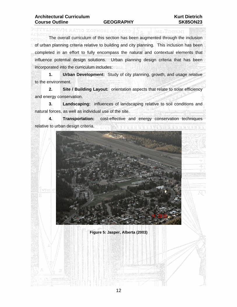
Figure 5: Jasper, Alberta (2003)

Architectural Curriculum Kurt Dietrich Course Outline GEOGRAPHY SK85ON23
13
The societal value of a building is calculated with regard to the architectural
design. The architectural design incorporates the technical aspects of construction but
also the sociological concepts of social setting, site development, location, and
responsiveness to the environment. There is an inherent link between the structure and
its site that can be viewed as distinct, though site contributes to the potential success of
a design.
The basic elements in the relationship between building and site are noted in the
‘Introduction’ as natural elements consisting of:
land forms / topography;
soil types;
orientation; and
wind and water elements.
Land Forms Land forms allow for the true creativity of architectural design. Design is, in one
respect, replication of land forms through the analogy of house to cave. Architectural
design encloses the existing space present on the land form, in a manner suitable to the
intended use. Architectural design does not create new space; it merely adjusts the
space that previously existed by enclosing it.
This explanation appears rather far-reaching and theoretical. It does, however,
relate directly to the aspect of architectural design that deals with creation of structures
within our given world.
The essence of land form analysis doesn’t stop at the ground level. It
encompasses the entire experience of a site location relative to the architect, client, and
potential occupant of the design. The encompassing explanation of elements stated by
Christian Norberg-Schulz is contained in the text “Genus Loci – Towards a
Phenomenology of Architecture”.

Architectural Curriculum Kurt Dietrich Course Outline GEOGRAPHY SK85ON23
14
1.0 Five Modes of Understanding C. Norberg-Schulz notes that our environment consists of individual elements,
each created with its own place. Place is the total of all visible and tangible elements
(materials, shape, texture, colour, size) that determine the environmental character. The
structure of “place” incorporates the three-dimensional organization of space which has
an atmosphere denoted by the characteristic properties of all elements combined.
This theory relative to land forms takes on a different dimension since it is
removed from our known physical realities of site, soil, sun, and natural forces. The
concept of resolving architectural design relative to land forms does involve the nature of
this theory in order to aesthetically as well as technically resolve a design problem.
Figure 6: Stonehenge, Salisbury Plain, England
The phenomenon of place requires an understanding of the human existence
between heaven and earth. To be able to understand involves knowledge of the
experience of meaning within our environment. This knowledge of experience of
meaning is specific to each culture/society as is reviewed in Section 4.0, Sociology and
Architecture. Meaning within any given culture relative to the specific land elements can
be traced to its belief system that incorporates elements of the five modes of
understanding.

Architectural Curriculum Kurt Dietrich Course Outline GEOGRAPHY SK85ON23
15
The five modes (methods or concepts) of understanding proposed in Genus Loci
include:
(1) Thing: relates to the tangible collection of site elements (rocks, soil,
vegetation) and creates the understanding of this collection as an entity unto itself –
Stonehenge is an entity made up of the elements of its location and structure, thereby
classified as a “thing’ in this definition. Meaningful places, collections of things, make the
life of the coherent civilization possible.
(2) Order: Order consists of the heavenly influence (a cosmic influence)
related to the local geographic structure. The relationship of the cosmic to the concrete
(land forms) creates an accepted structure of the “place”; a union of earth and sky
(cosmos) to define an order.
(3) Character: relates to the definition of natural elements, relating them to
human traits. This aspect is commonly referred to as assigning characteristics to
inanimate objects. The assignment of human characteristics to natural elements creates
an understanding of the land form and location.
(4) Light: Light is symbolic within our civilization as being a positive element,
source of inspiration, and related to the heavens through the religious overtones applied
to the presence of light. An understanding of the forces and nature of light relative to the
land forms (duration, intensity, clarity) will provide for a more resolved design solution.
Light is, however, temporary as it changes throughout the day and over the seasons. It
is inherently connected with the rhythms of nature through the seasons.
(5) Time: Time incorporates the rhythm of our existence as we move in and
around our chosen spaces. The element of time, like that of light, is in a constant state
of movement, always changing but never repeating. These two latter elements clearly
reflect the existence of civilization on earth, though the presence of the land (earth)
remains a constant.

Architectural Curriculum Kurt Dietrich Course Outline GEOGRAPHY SK85ON23
16
These five modes of understanding are essential to facilitate a full understanding
of the land forms present in an architectural design solution. These five modes relate to
the original theory of dwelling between earth and sky through the classification as
follows:
• Earthly aspects are characterized by the elements found in the modes of
‘Thing’ and ‘Character’. These modes relate to the physical aspects of
land forms and natural elements.
• Heavenly (sky) aspects are characterized by the elements found in the
modes of ‘Order’ and ‘Light’. These modes relate to the cosmic
influences felt upon a particular site area or region.
• ‘Time’ is the mode assigned to neither heaven nor earth since time is both
ever-changing (as the heavens) and constant in its progress (the constant
relating to earth). Time is also that element that is assigned to the
specific period of civilization relative to the architectural practices.
Figure 7: G. Pompidou Centre, Paris, France (1973)
Section 1.0 – Architectural History of Western Civilization illustrates the changes
in design over time within a given geographical region. Neither the earthly nor the
heavenly aspects of the land forms within a given region have changed, yet architectural
design has progressed over time.

Architectural Curriculum Kurt Dietrich Course Outline GEOGRAPHY SK85ON23
17
The combinations and influences of these modes relative to place have been
essential in the architectural design of those works considered as achievements.
Figure 8: Fallingwater, Racine, Wisconsin (1936) Frank Lloyd Wright’s design solution for Falling Water (Racine, Wisconsin) is a
prime example of place with considerations to all the influential factors of land definitions
noted. The structure rests as a part of the landscape yet distinct, as well as provides
integration between the interior and exterior.
Figure 9: Integration to Exterior

Architectural Curriculum Kurt Dietrich Course Outline GEOGRAPHY SK85ON23
18
Though a full descriptive analysis of major works exceeds the nature of this
curriculum, other examples can be found in every location of design:
Swiss houses nestled into the hillside reflect the cultural values and spirit of
their time as well as integrate with their place
Figure 10: Lac Biernsee, Interlaken, Switzerland .
The work of Douglas Cardinal, as seen in both the Museum of Civilization
(Ottawa) and the First Nations University of Canada (Regina), reflects his
philosophy of nature, culture and form relative to architecture design. This
philosophy stems from his ancestral relationship with earth, sky, and natural
forces to create an architectural resolution symbolic of our landscapes.
Figure 11: Museum of Civilization, Ottawa, Ontario
Architectural Curriculum Kurt Dietrich Course Outline GEOGRAPHY SK85ON23
19
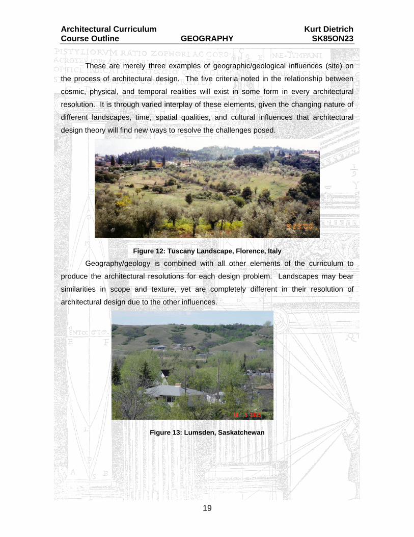
These are merely three examples of geographic/geological influences (site) on
the process of architectural design. The five criteria noted in the relationship between
cosmic, physical, and temporal realities will exist in some form in every architectural
resolution. It is through varied interplay of these elements, given the changing nature of
different landscapes, time, spatial qualities, and cultural influences that architectural
design theory will find new ways to resolve the challenges posed.
Figure 12: Tuscany Landscape, Florence, Italy Geography/geology is combined with all other elements of the curriculum to
produce the architectural resolutions for each design problem. Landscapes may bear
similarities in scope and texture, yet are completely different in their resolution of
architectural design due to the other influences.
Figure 13: Lumsden, Saskatchewan

Architectural Curriculum Kurt Dietrich Course Outline GEOGRAPHY SK85ON23
20
2.0 Topography and Soils
Figure 14: Saskatchewan Map
The topography (land slopes) of any given site bears an influence on the
architectural solution as well. Saskatchewan, as an entity, is considered flat when in fact
over half of the province’s land area is lakes and forest. The City of Prince Albert,
considered to be Northern Saskatchewan, is actually near the geographical centre of the
province. The southern half of the province as a whole is far from flat, as is indicated by
visible land forms photographed in winter. The solutions for prairie architecture remain
as varied as the landscape and every specific location which creates its own definition of
“Place”.
Figure 15: South-West Saskatchewan (Winter 2003)

Architectural Curriculum Kurt Dietrich Course Outline GEOGRAPHY SK85ON23
21
Soil Types Soil types bear a great deal of influence on the structural nature of the
architectural design, being more technical in nature. The various structural systems
(foundations specifically) are reviewed in Section 2.0 - Science of Buildings.
The ways in which soil type and consistency will influence the intended design
solution stem from the structural stability (determining potential building height and
mass) as well as the aesthetic resolution. The soil type forms the basis of the
landscape, presenting opportunities for design resolution either in keeping or in contrast
with the existing environment. This item is closely linked to the aforementioned land
forms and definition of place.
Landforms created through the soil definition can be classified according to the
topography and the impact of moisture on the surface and sub-surface conditions. A
brief summary of landform classifications includes:
(1) Flood Plain: The lowest land area relative to water accumulation. This
area would be subject to flooding easily. These areas are typically
restricted to little or no development.
(2) Alluvial Fan Area: This land area is immediately adjacent the flood plain
zone. This area is often subject to heavy moisture concentration as the
bulk of draining water (heading for the flood plan) drains over it. Erosion is
heavy on the soil surface. The depth of moisture penetration is often
extreme. These areas are typically limited to select development types
only.
(3) Uplands: This land area is above the Alluvial Fan zone, shedding
moisture easily. Depending on the soil type, development is often
permitted in these areas. The control of runoff is a serious consideration
within developed zones.

Architectural Curriculum Kurt Dietrich Course Outline GEOGRAPHY SK85ON23
22
(4) Low Uplands: This land area comprises the depressions found within the
Upland zones. Development is controlled in these areas due to the
presence of runoff that can quickly accumulate, making the soil soft and
undesirable.
(5) Hillside: Hillside areas drain well, although they are often subject to deep
erosion, causing instability in the soil surface. These areas may be subject
to slippage depending on the season and precipitation levels.
Development is controlled in these areas due to the erosion and slippage
concerns.
(6) Ridge and Highlands: These areas generally provide well-drained soil
conditions with low erosion concerns. These areas are considered the
best building sites available.
Soil Erosion: Erosion of the soil and sub-surface caused by water runoff is a critical concern
due to the deterioration that can be created. As the topsoil is eliminated, water
absorption is increased in the sub-soils which may affect swelling and damage to the
foundations. (Refer to Section 2.0, Science of Buildings). Wind erosion is a concern on
open prairie landscapes but not considered critical in the urban areas.
Figure 16: Raindrop Impact on Soil Water erosion removes soil by mixing with the materials as the rain strikes,
creating a light density mud mix. These soil elements are then transported through the
runoff to the lowest available land point.

Architectural Curriculum Kurt Dietrich Course Outline GEOGRAPHY SK85ON23
23
Erosion of the soil and sub-surface elements is increased depending on the land
slopes (topography) and consistency of the soil. Newly placed soil in
construction/development areas is particularly sensitive to erosion as there has been
little compaction of the soil, keeping it loose and subject to run-off. The topography
slopes can be categorized as:
Figure 17: Slope types and fill in developments
Four types of runoff erosion may occur on site, depending on the precipitation
intensity and density of the soil types. The erosion types are:
(1) Sheet Erosion – removes the entire soft top level of soil in one wash-off.
(2) Rill (Trough) Erosion – removes soft pockets in the soil and subsoil,
creating pockets and creases down the slopes.
(3) Gully Erosion – rill erosion that has increased in size and scope to carve
out a large slash through the hillside.
(4) Slip Erosion – the most catastrophic type of erosion. Water penetration
accumulates in the soft subsoil layer, creating a massive single movement
of soil. This type represents the “mud slides” that remove the sides from
hills and slopes in a single effort. The power of this slide type may be
extreme, causing great damage.
Figure 18: Sheet Erosion after Excavation

Architectural Curriculum Kurt Dietrich Course Outline GEOGRAPHY SK85ON23
24
Erosion and control techniques are frequently used to minimize the overall impact
of surface water. Landscaping elements are the simplest means to control erosion by
their actions above and below the soil surface.
Figure 19: Landscape Slope Elements
Landscaping provides control by:
breaking the velocity of water down as the leaves and branches act as
canopies and diffusers;
solidifying the subsoil through their root systems; and
dead leaves and plant parts mix with the topsoil, loosening it and creating
capacity for increased absorption, thus minimizing the runoff.
Other methods of erosion control include retaining walls, erosion bars and runoff
control methods through culverts and storm channel drains.
Figure 20: Hillside Retaining Wall System

Architectural Curriculum Kurt Dietrich Course Outline GEOGRAPHY SK85ON23
25
3.0 Orientation Orientation of a design solution references the key or critical direction that the
building is to face. In some cases, such as urban infill or downtown redevelopment, the
choices to vary the orientation of the building’s main façade are limited. It is possible to
use orientation of building elements (doors, windows, balconies, roof slopes) to enhance
the design and provide a means of environmental control.
Figure 21: Roman Orientation
The basic orientation desired for most structures is south to take advantage of
our climatic exposure to the sun. There is no clear, black-and-white solution to
orientation due to the many factors that interact in determining the site design aspects.
Figure 22: Orientation Considerations (Vitruvius)

Architectural Curriculum Kurt Dietrich Course Outline GEOGRAPHY SK85ON23
26
The examples noted below illustrate the complexity of our climatic southern exposure:
Solar exposure in the winter months assists in lowering the mechanical
heating load.
Solar exposure in the summer months may increase the mechanical cooling
load.
Southern exposure will expose the structure to the cooler summer winds, but
the design must reflect this opportunity to incorporate the wind pattern into the
site areas.
Landscaping may be installed in the form of deciduous trees to provide
summer shade (lessening the solar impact).
Deciduous trees lose their leaves in winter, thereby allowing full solar access
to the structure.
Landscaping may, however, serve as a windbreak relative to the intended
capturing of summer breezes. This landscaping (trees and potential ground
cover) will require careful design considerations in order to allow summer
winds through or around while still providing the intended shade element.
Figure 23: Orientation and Landscaping

Architectural Curriculum Kurt Dietrich Course Outline GEOGRAPHY SK85ON23
27
The relationship of architectural design to site concepts (orientation, wind, water)
is clearly a complex problem that requires as much consideration as the design elements
themselves. The examples noted herein are merely a cursory review of some
considerations present in orientation. These considerations may be discarded in the
case of a client who wishes to paint canvases in a studio providing nothing but the soft
natural light of the northern side. This one contradiction would then provide its own set of
orientation and siting considerations, from a different point of view than illustrated earlier.
Figure 24: Place des Vosges, Paris, France
Orientation plays a role in siting the intended design when considering the
additional activities or site elements to be included in the design solution. The
architectural design process must step away from the immediate building to consider the
land area and actions involved. This process includes parking, mass-transportation,
pedestrian access, landscaping, site features, and the potential adjacent structures
(existing or proposed). The elements discussed with respect to orientation carry
significant impact on all of the site elements, individually and as a component of the
overall design solution.

Architectural Curriculum Kurt Dietrich Course Outline GEOGRAPHY SK85ON23
28
4.0 Solar Orientation
Figure 25: Solar Skyspace / Travel Considerations
Solar orientation refers to the altitude and azimuth of the sun during the seasons.
The altitude angle is the angle above the horizon line immediately below the sun’s
position. The azimuth angle is the sun’s position horizontally, measured clockwise from
north, as it travels from east to west. These two angles combine to provide the exact
location of the sun, allowing a response within the architectural design process to take
advantage or counteract the solar influence.
Figure 26: Altitude / Azimuth Locations
Architectural Curriculum Kurt Dietrich Course Outline GEOGRAPHY SK85ON23
29
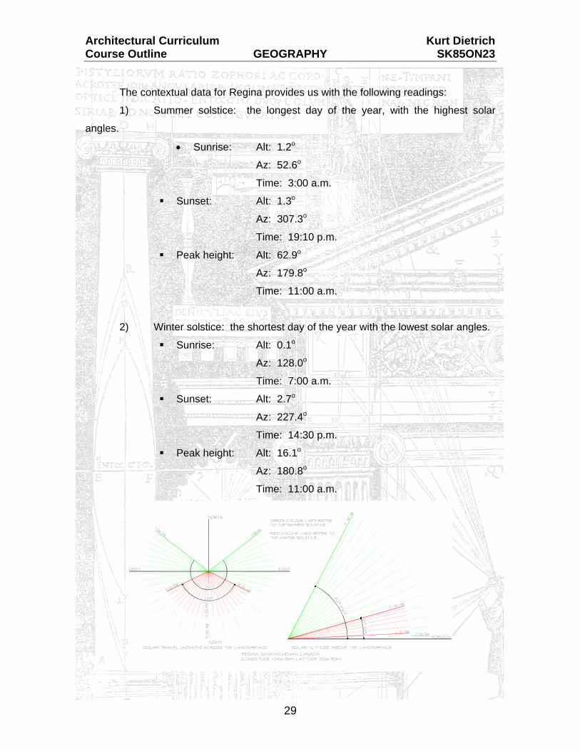
The contextual data for Regina provides us with the following readings:
1) Summer solstice: the longest day of the year, with the highest solar
angles.
• Sunrise: Alt: 1.2o
Az: 52.6o
Time: 3:00 a.m.
Sunset: Alt: 1.3o
Az: 307.3o
Time: 19:10 p.m.
Peak height: Alt: 62.9o
Az: 179.8o
Time: 11:00 a.m.
2) Winter solstice: the shortest day of the year with the lowest solar angles.
Sunrise: Alt: 0.1o
Az: 128.0o
Time: 7:00 a.m.
Sunset: Alt: 2.7o
Az: 227.4o
Time: 14:30 p.m.
Peak height: Alt: 16.1o
Az: 180.8o
Time: 11:00 a.m.

Architectural Curriculum Kurt Dietrich Course Outline GEOGRAPHY SK85ON23
30
By this simple comparison, we can establish that for Regina, the sun is
approximately 46.8 degrees lower in altitude, travels approximately 155o less across the
horizon, and shines approximately 8.5 less hours at winter solstice than summer
solstice. All other solar angles and paths of travel occur between these two extremes.
Orientation of site elements and structure must take into account these
influences during the seasons in order to respond to the natural solar force present.
Orientation is also crucial with regard to the items reviewed within Section 2.0, Science
of Buildings. The temperature extremes and exposure of building materials has a major
influence on how the structure moves with regard to thermal properties of the materials.
Solar and wind orientation have an effect on the occupancy of the design as well as the
intended lifespan of the building’s components. The materials discussion was completed
within Section 2.0 and may be reviewed relative to geographic orientation.
Figure 27: Solar Considerations

Architectural Curriculum Kurt Dietrich Course Outline GEOGRAPHY SK85ON23
31
Orientation also plays a role in the appearance of the design from both the
exterior and interior. The approach to the structure, views presented, and means of
exposure will influence the experience of the user. The interior views will have an equal
influence on the occupants of the facility, on an ongoing basis throughout their time
there.
Figure 28: Scarth Street Dining
Architectural design cannot exist in a vacuum, sealed away from the influences of
site elements (orientation, natural forces). A critical element that is considered during
the design process is the potential exposure of both spaces (interior and exterior) as
they relate to each other. Architectural design is required to go beyond the immediate
confines of the structure to include the site elements, views available from within, and
appearance from the exterior. A properly resolved design solution provides for each
aspect to the best of the available opportunities.

Architectural Curriculum Kurt Dietrich Course Outline GEOGRAPHY SK85ON23
32
This design requirement takes into consideration the space (site) around that
which is enclosed (building) in order to meld building to site. It is the process of sharing,
to bring the exterior in while extending the interior out. In some cases, this process may
require modifications at the ground floor level in order to eliminate the building’s affect
(presence on the site). This design resolution creates a compromise of available floor
space with the positive result of integration with the site.
Figure 29: St. Peter's Square, Rome, Italy
The use of site orientation and exterior enclosure is evident in courtyards and
plazas within the urban environment, dating back to the Roman period when the
approach to a structure was a prime consideration. St. Peter’s Square in Rome
(completed during the Renaissance/Baroque periods), illustrates the example of
enclosing a site to enhance the overall experience of the design of St. Peter’s itself.

Architectural Curriculum Kurt Dietrich Course Outline GEOGRAPHY SK85ON23
33
5.0 Wind & Water Elements Wind elements are an important part of architectural design. Our climate,
especially in Saskatchewan, features an abundance of wind currents throughout all of
the seasons.
Figure 30: Prairie Landscape
The ‘Science of Buildings’ curriculum noted the powerful influences that wind can
have on the built environment. Pressures caused by thrust or negative suction can
effectively pull a structure apart. Designing for wind carries the structural concern at its
base point in the process. Wind considerations were prevalent even during the time of
Vitruvius as indicated by his chart of wind orientations.
Figure 31: Vitruvian Wind Orientation Diagram

Architectural Curriculum Kurt Dietrich Course Outline GEOGRAPHY SK85ON23
34
Designing for wind effects must consider the major directional sources for each of
the seasonal wind patterns. Our climatic atmosphere provides winter winds (cold and
dry) affecting structures from the northwest direction. Summer winds (cooling and moist)
generally approach from the southeast, directionally opposite to the winter wind patterns.
The opportunities to capitalize on these wind patterns are such that they can provide a
cooling element to serve the building function through the summer months, while an
effective means to block or deflect the winter winds from the structure’s entry points must
be designed. In essence, the design may wish to allow summer winds and block winter
winds.
Figure 32: Wind Orientation
New design technologies are creating ways to use the natural wind patterns to
assist in air movement throughout a structure, thereby lowering energy usage of the
mechanical ventilation system. This technology stems from the basic idea that if you are
hot, open the window; if cold, close it. Operable windows won’t provide the desired
breeze (cooling effect) if their orientation is on the negative side of the wind pattern. This
act may in fact draw air through the interior area, bringing odours and moisture to exit
out the open window. Operable windows are also quite limited in vertical range (high-
rise developments) due to the atmospheric pressures present both inside and outside a
building shell.

Architectural Curriculum Kurt Dietrich Course Outline GEOGRAPHY SK85ON23
35
The new technology uses the established wind patterns to create negative
pressures at the top of a building, which are offset by positive pressures at the base. In
this fashion, the wind element acts as a natural ventilation system; entering at the base,
moving air vertically through the building (in a controllable fashion), and exiting as
exhaust at the top. This new technology requires a respect of the existing site wind
patterns in order to achieve its goal of using wind to lower the mechanical requirements.
Figure 33: Eco-Tower, London, England
(T.R. Hamzah & Yeang Architects)
Eco-Tower has two major openings, one at the north façade and another at the south façade, allowing wind to enter into internal passageways and lobbies either to vent and cool these spaces or to provide cross-ventilation to the apartment units. These have shutters at the façade openings, which can open and shut at varying levels of closure depending on the weather and building operations. Key components of "passive-mode" energy savings come from wind-induced ventilation, daylighting in the summer and solar heating in the winter.
Architecture Magazine, Dec 2002, P. 53
Architectural Curriculum Kurt Dietrich Course Outline GEOGRAPHY SK85ON23
36
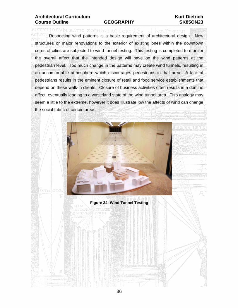
Respecting wind patterns is a basic requirement of architectural design. New
structures or major renovations to the exterior of existing ones within the downtown
cores of cities are subjected to wind tunnel testing. This testing is completed to monitor
the overall affect that the intended design will have on the wind patterns at the
pedestrian level. Too much change in the patterns may create wind tunnels, resulting in
an uncomfortable atmosphere which discourages pedestrians in that area. A lack of
pedestrians results in the eminent closure of retail and food service establishments that
depend on these walk-in clients. Closure of business activities often results in a domino
affect, eventually leading to a wasteland state of the wind tunnel area. This analogy may
seem a little to the extreme, however it does illustrate low the affects of wind can change
the social fabric of certain areas.
Figure 34: Wind Tunnel Testing

Architectural Curriculum Kurt Dietrich Course Outline GEOGRAPHY SK85ON23
37
Figure 35: Primary Wind Control
Winds can be controlled or modified in ways that provide a more suitable
environment.
Modifications to the land forms near or adjacent a new structure can
assist in deflection or lower the overall impact on the structure.
Wind blocks such as retaining walls can be constructed at key
locations to deflect and redirect the wind flow away from the
structure (especially the entrance area).
Landscaping (trees and shrubs) will aid in breaking the wind force
down which lowers its overall impact once it reaches the structure.
Figure 36: Landform/Landscaping Protection

Architectural Curriculum Kurt Dietrich Course Outline GEOGRAPHY SK85ON23
38
These examples speak towards resolution of the undesirable wind’s presence
related to the building’s site. Equal and opposite affects can be achieved in using each
of these elements to enhance and redirect cooling winds into the structure during the
summer months.
Figure 37: Cooling Effects (Summer Winds)
It is possible within the process of architectural design to incorporate wind
elements that serve the best interests of the intended solution while excluding those
elements that may cause undue stress and discomfort for the intended users.
The manipulation of wind elements is only one component of the site aspects that
must be considered during the architectural design process.
Water elements related to urban design carry an aesthetic consideration but they
focus mainly on storm water retention. Storm water refers to both winter run-off and
rainwater. As our cities expand, the current infrastructure becomes too small to handle
additional flow of water during peak periods. It may not seem like a great amount of rain
may have fallen during a rainstorm (perhaps only 12 mm), but that amount when
collected from an entire subdivision can cause flooding and spills.
The current practice of urban design is to incorporate retention ponds into the
urban layout (suburban in some cases) to collect and retain this water until such time as
it can be siphoned off through controlled drainage or evaporation occurs.

Architectural Curriculum Kurt Dietrich Course Outline GEOGRAPHY SK85ON23
39
New areas (Lakewood and Lakeridge) are being designed to incorporate the
water retention area as an aerated lake, contributing a public, social use as well as a
functional, operational aspect. This technique has proven effective in areas of the City
of Calgary (Lake Buenavista, Lake Midnapore, Lake Sundance) where the lakes include
beaches, boating, and fishing; all located within the urban setting.
Figure 38: Lakeridge Subdivision, Regina, Sask.
Water elements are also used in building designs on both the interior and exterior
for functional and aesthetic purposes. Moving or aerated water provides background
noise (termed “white noise”) within public spaces. White noise is a means to deflect
auditory perception, masking conversations between adjacent groups and removing the
emptiness often felt within large public spaces. Water elements also contribute to the
humidification (airborne moisture) of public spaces, alleviating the dry climate
experienced, particularly in Saskatchewan.
Figure 39: Queen Elizabeth Court, City Hall, Regina

Architectural Curriculum Kurt Dietrich Course Outline GEOGRAPHY SK85ON23
40
Water elements can be included into architectural designs in several ways, such
as:
Stillwater ponds: reflective pools with only minimal surface disruption. These
items are used primarily within zones of contemplation or public seating.
Fountains: create both noise and movement. The interplay of water and light
create a distinct atmosphere when used in the proper context. Fountains are
used on both exterior and interior applications to augment spatial qualities.
Waterfalls: can be used in lieu of the fountain in situations that place the water
source away within the space. Waterfalls provide similar effects with noise and
lighting as a fountain.
Figure 40: Exterior Fountain, SPC, Regina
The proposed use, placement, and design of the water element are crucial to the
success within the space. Noise qualities must be considered in order to properly select
and design the water feature. It is possible to adjust the noise component based on the
type of water element selected.
Water is an essential component of the human existence. The most prevalent
aspect of water included in the design is that water must be kept in motion to prevent
stagnation. The same philosophy can be stated with regard to the human existence.

Architectural Curriculum Kurt Dietrich Course Outline GEOGRAPHY SK85ON23
41
Water can also be an effective destructive force related to structures and
landscaping. Our climate features water (moisture) in all its forms (fog, rain, show, ice),
each of which must be carefully considered during the design process.
The process of handling and manipulating rainwater, snow and ice is a design
element that can contribute to either the success of the design or its failure.
Features for water management can play a role in the aesthetic of the design or
the design may in fact hide or remove these features from the end product. In both
cases, a rational design decision must be reached as to the nature of the resolution.
This decision will then carry forward as one of the many design choices made within the
process.
Architectural Curriculum Kurt Dietrich Course Outline GEOGRAPHY SK85ON23
42
6.0 URBAN DESIGN
The other side of geographical analysis relevant to the curriculum involves the
study of urban design.
Civilizations have settled in constructed environments since 6,000 BC as noted in
Section 1.0, Architectural History of Western Civilization. The design, growth and
evolution of these settlements has taken on a character unique to the order of the time.
Social roles, spatial qualities and societal structure all play a part in the analysis of the
urban environment, yet we are all too often willing to accept the growth of our cities
unchallenged. This willingness to abide by the social will, allowing for growth unchecked
and ad-hoc, has led our society to the point of excessiveness in land and energy use.
To allow for growth outward of our civic centres also allows for deterioration of
the centres themselves. This condition is evident within the City of Regina as well a
other major centres across Canada an the United States. This condition is also felt in
Western European centres but not to the degree that it has proliferated locally.
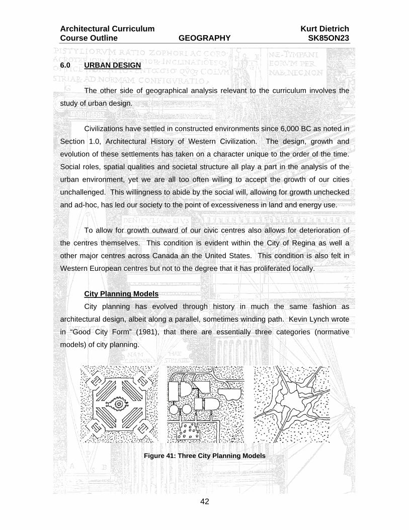
City Planning Models City planning has evolved through history in much the same fashion as
architectural design, albeit along a parallel, sometimes winding path. Kevin Lynch wrote
in “Good City Form” (1981), that there are essentially three categories (normative
models) of city planning.
Figure 41: Three City Planning Models

Architectural Curriculum Kurt Dietrich Course Outline GEOGRAPHY SK85ON23
43
(1) The Cosmic Model: otherwise termed the “Holy City” type. This model
plans the civic environment as an interpretation of the universe and
prevailing belief system (the gods). It is laid out as articulated expression
of power as seen in the idealistic plans of the Renaissance and Baroque
periods. Characteristic design features include:
the monumental axis,
the enclosure of the environment complete with gates at the
entries,
dominant landmarks,
reliance on a regular grid layout, and
spatial organization by social hierarchy.
Figure 42: Palmanova, Italy (1593)

Architectural Curriculum Kurt Dietrich Course Outline GEOGRAPHY SK85ON23
44
(2) The Practical Model: otherwise referred to as “the city as a machine”.
This model is factual, functional, and analytical. Magic or beliefs play no
part in its formation. The design features identified are characteristic of
those found in factory towns, colonial settlements, speculative grid towns
of the United States, and Le Corbusier’s theoretical ‘Radiant City’ plan.
The city in this model is “made up of small, autonomous, undifferentiated
parts, linked up to a great machine which in contrast has clearly
differentiated functions and motions”.
Figure 43: The Radiant City
Architectural Curriculum Kurt Dietrich Course Outline GEOGRAPHY SK85ON23
45
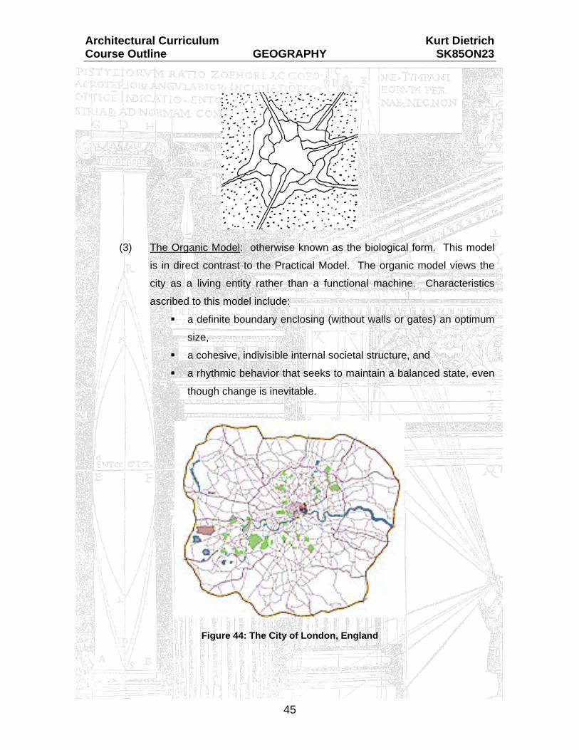
(3) The Organic Model: otherwise known as the biological form. This model
is in direct contrast to the Practical Model. The organic model views the
city as a living entity rather than a functional machine. Characteristics
ascribed to this model include:
a definite boundary enclosing (without walls or gates) an optimum
size,
a cohesive, indivisible internal societal structure, and
a rhythmic behavior that seeks to maintain a balanced state, even
though change is inevitable.
Figure 44: The City of London, England

Architectural Curriculum Kurt Dietrich Course Outline GEOGRAPHY SK85ON23
46
These models provide merely the basis for urban review. In practicality, all cities
contain some components of each model, though one model may take precedence. In
every case (cosmic, functional, or organic), our cities will be faced with periods of
upheaval due to philosophical change (cosmic), functional breakdown (practical), or
urban blight/disease (organic). These crisis periods are the points of departure in city
planning where new theory or concepts are implemented to correct the growth or
imbalance in the civic system.
Figure 45: Karlsruhe, Germany (1715)
The social concepts of spatial order related to the specific culture are present in
all schemes, depending on the time they originated. These social concepts
corresponded with the cultural hierarchy, centering wealth and power within the city with
agrarian, rural existence on or outside the borders. The early plans derived by the
hierarchy structure were fortified by the presence of the leader (King) at the centre, the
location where all would gather during times of siege or distress.

Architectural Curriculum Kurt Dietrich Course Outline GEOGRAPHY SK85ON23
47
Energy and Environmental Design: The industrial revolution created a major upheaval in the mobility of the urban
classes. Prior to this period, urban excursions were limited to the rich escaping the city
for villas or estates for a brief respite. Industrialization laid the groundwork for grid
planning; simple, effective use of the landscape to suit housing and urban demands of
the new urban dwellers (the industrial workers).
Transportation systems (trains and vehicles) further pushed the urban
environment by allowing for daily travel to work, accessing cheaper land for
development, and increasing the overall urban footprint. This trend continues to date
with the sprawl of suburbs, a nickname given to developments outside the original urban
core, thus creating sub-urban developments.
This overview of civic development is an intensely abbreviated summary of the
growth in civic environments. A total assessment of civic growth must consider the
historical, social, cultural, lifestyle, education, and labour force of each location relative to
its origins and growth. Numerous texts and studies have been completed relative to the
city, too many to detail in this text. The underlying concept that we wish to explore is the
current trends at play in our civic environments relative to architectural design and urban
planning.
The existing sprawl of our cities creates a reliance on transportation for almost
every aspect of our daily lives. Work locations, shopping, schools, recreation, and even
places of worship are far-flung and removed from the residential locations. Low density
residential development makes mass transportation methods too costly to prove
effective, thus the reliance on the personal vehicle. The reliance on personal vehicles
generates associated concerns of increased pollution, energy usage, loss of green
space as roads chew up the landscape, and environmental decay.

Architectural Curriculum Kurt Dietrich Course Outline GEOGRAPHY SK85ON23
48
Energy consumption and conservation are critical issues that we face today with
regard to architectural and urban design. The issue of energy consumption arises from
the fact that over 35% of end-use energy is used in our buildings. Over 2/3 of this
amount is used on heating our spaces. Buildings themselves through utility usage,
construction and materials, and generated waste, account for up to 40% of the energy
use in our society.1
Figure 46: North-West Regina Energy consumption within the built environment (residential, commercial,
institutional) is affected by many factors relative to the equipment (age and efficiency)
and the manner by which these buildings are maintained. Energy consumption is directly
affected by architectural design in many individual and combined ways, including:
overall building form,
building type and occupancy,
density of buildings on land area,
internal building layout,
individual building components (insulation, air barrier, etc.) and the
method of construction,
site orientation (as discussed previously), and
landscaping elements.
1 Planning Land to Conserve Energy, P. 5

Architectural Curriculum Kurt Dietrich Course Outline GEOGRAPHY SK85ON23
49
Architectural design can alleviate many of the consumption factors through
thoughtful consideration of the issues and an honest response in the final design. The
definition of ‘Honesty’ refers back to the theoretical position of the architect as discussed
in the introductory chapter of Section 3.0, Art in Architecture.
Several opportunities to provide a suitable response to energy consumption
challenges are noted below. These suggestions are merely items to consider while the
overall process of architectural design is underway. These suggestions will not
necessarily be applicable in every instance, and compromises will be generated
depending on the site specific, programmatic requirements, and individual mandate of
each design challenge.
Opportunities to lessen the overall amount of energy consumed by commercial
and institutional buildings may be generated by:
(1) Site Selection:
Select sites that allow the maximum exposure to the sun (solar
access) for the building area.
Attempt to locate a site near major traffic generators and mass transit
opportunities in order to lower the requirement for vehicle usage.
Attempt to locate a site that provides access to mass transit routes
(lowering the personal vehicle waste).
Re-use or reclaim sites within the developed urban areas to make the
best use of the existing infrastructure (roads, sewer, water).
Design the site to maximize the potential for the south yard, placing the
design solution north of the mid-way point.
Preserve or plant landscaping that provides shelter yet allows solar
access during the cool seasons. (Coniferous trees on north and west,
deciduous trees on south and east).
Respect the existing site drainage patterns (landscaping will assist in
topsoil retention).
Reduce scattered land usage.
Architectural Curriculum Kurt Dietrich Course Outline GEOGRAPHY SK85ON23
50
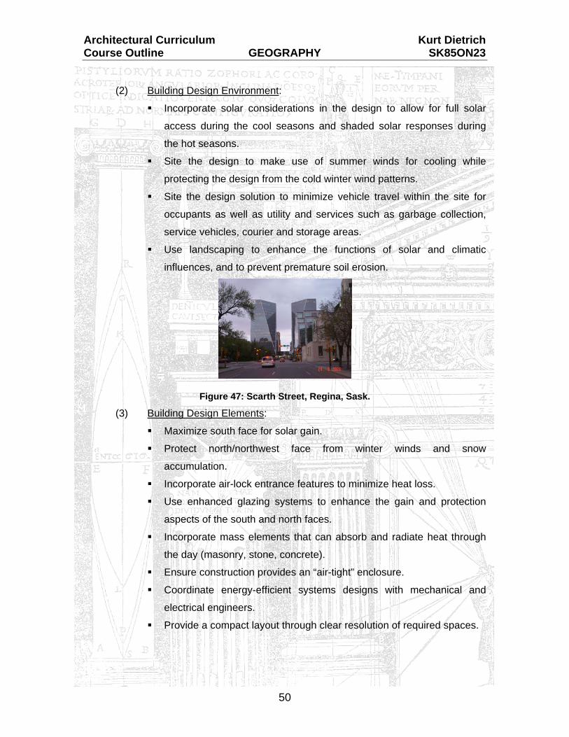
(2) Building Design Environment:
Incorporate solar considerations in the design to allow for full solar
access during the cool seasons and shaded solar responses during
the hot seasons.
Site the design to make use of summer winds for cooling while
protecting the design from the cold winter wind patterns.
Site the design solution to minimize vehicle travel within the site for
occupants as well as utility and services such as garbage collection,
service vehicles, courier and storage areas.
Use landscaping to enhance the functions of solar and climatic
influences, and to prevent premature soil erosion.
Figure 47: Scarth Street, Regina, Sask. (3) Building Design Elements:
Maximize south face for solar gain.
Protect north/northwest face from winter winds and snow
accumulation.
Incorporate air-lock entrance features to minimize heat loss.
Use enhanced glazing systems to enhance the gain and protection
aspects of the south and north faces.
Incorporate mass elements that can absorb and radiate heat through
the day (masonry, stone, concrete).
Ensure construction provides an “air-tight” enclosure.
Coordinate energy-efficient systems designs with mechanical and
electrical engineers.
Provide a compact layout through clear resolution of required spaces.

Architectural Curriculum Kurt Dietrich Course Outline GEOGRAPHY SK85ON23
51
Energy consumption and conservation related to urban design is another critical
issue to consider. Transportation systems use over 25% of the total energy
consumption expended. Over half of this energy is used up through automobile usage,
with at least one-third of this consumption related to urban transportation movement
alone. Statistics related to urban transportation indicate that 90% of automobile energy
use is expended moving people, while only 10% is used to move goods.2 There may
seem to be a lot of trucks moving about the city but they account for a very small
percentage of the expended energy. It is the configurations of our cities that have
necessitated a major portion of the required urban travel. Societal and cultural
influences carry some weight in this issue since we are known as a “vehicular society”,
however this influence is not as easily addressed as the civic layout consideration.
Civic Environmental Design: Civic growth as illustrated earlier in this section can be categorized as one of
cosmic, practical, or organic. Our current civic environments are typically a combination
of practical and organic, with the occasional cosmic influence. This cosmic influence is
minimal and sporadic, not considered further in our analysis.
Figure 48: Regina, Saskatchewan The Practical Model is found in the gridiron, rectilinear street patterns of the
centre urban areas. The Organic Model is found in the curved, cluster-type
developments of the outlying expansion areas. An interesting note is that the practical
system was the original system, laid out in typical fashion of its time when mankind
enforced its principles on the landscape, almost regardless of the terrain.
2 Planning Land to Conserve Energy, P. 6

Architectural Curriculum Kurt Dietrich Course Outline GEOGRAPHY SK85ON23
52
The practical (gridiron) system represents the early days of civic planning.
Streets are planned at right angles and could be extended indefinitely over the
landscape. This system type was easy and efficient to establish on almost any terrain.
Utility installation was easy as well as the street numbering system. The rectangular
blocks were easy to subdivide into development parcels. The entire system seems to
have a lot of positive aspects, however the inherent flaws surfaced during the actual
usage.
Figure 49: City of Regina Downtown District
Flaws in this system include the fact that the layout does not adapt well to
irregular topography without land surface relocation. This system type also makes travel
to a diagonal point difficult. Any street in this system may be considered a heavy traffic
route which then requires increased artificial controls in terms of lights, signage,
blockage, and one-way use. The implementation of controls within a street layout can
cause slow-downs in traffic flow, which will increase the time a vehicle is on the road
running, resulting in a subsequent waste of energy. There is a domino effect present
whenever controls or regulations are instituted within our urban development, especially
where energy consumption is concerned.

Architectural Curriculum Kurt Dietrich Course Outline GEOGRAPHY SK85ON23
53
The organic (cluster) system represents the more recent trend in urban design.
Streets are varied in width, depending on their designed usage according to the intended
traffic flow. Street types were categorized as:
(1) Arterial streets – fast moving traffic designed for peak flow; the main roads
(Albert Street, Victoria Avenue, downtown). Widths vary from 80 feet to
120 feet.
(2) Collector streets – moderate traffic speeds for varying flow. These streets
are intended to serve as the link between minor streets and arterial streets
(such as Hillsdale Street). Widths are 60 feet to 80 feet.
(3) Minor streets – residential entry roads that link the marginal streets to
collectors. Minor streets are a part of the residential or commercial zone,
being developed for use. These streets carry minimal to moderate traffic
at low speeds within the intended zone. Widths are 50 feet to 60 feet.
(4) Marginal access streets – minor streets that are parallel or adjacent to the
arterial or collector streets. These streets provide access to immediate
properties only, linking onto the minor streets for urban access. Widths
are ± 40 feet.
(5) Alleys / Laneways – these are the back access roads seen mostly in older
development areas. Current urban planning techniques include an
easement between properties at the back. Newer developments have
eliminated this access road entirely.
Figure 50: Organic Subdivision Layout

Architectural Curriculum Kurt Dietrich Course Outline GEOGRAPHY SK85ON23
54
Organic planning strategies have to come up with fixed boundaries to the
development since growth in a controlled manner cannot be extended like the gridiron
system can. The presence of these boundaries limits development to a fixed area.
Positive aspects of organic (cluster) developments include:
Grouping of development units allows for potential increase in socialization.
(Refer to Section 5.0, Sociology and Architecture).
Grouping of developments allows for unused land areas to serve common
uses (urban or residential parks, green spaces, etc.).
Density of building development remains consistent with practical (gridiron)
system. Additional open area is created without losing any developed lands.
Development costs may be lower for utility installation and servicing.
Natural drainage systems can be implemented much easier than in the
practical system. The organic model can use the existing topography as the
initial indicator of the future layout.
Figure 51: Cluster Groupings Road systems can be narrowed to specifically suit the intended use. Since
the border is fixed (unlike unlimited expansion opportunity of practical
system), the potential for increased travel volume is minimal. Narrowing
roads reduces the overall land usage, resulting in less development costs
and future servicing. Less asphalt area also means more area of the natural
topography can remain for drainage and green space.
Orientation of the individual development sites is more varied than in the
practical system. This opportunity provides more flexibility for the potential
design solutions on each development site.
Open areas within the organic (cluster) development may be used for storm
water retention ponds, thereby reducing the demands on existing systems.
Architectural Curriculum Kurt Dietrich Course Outline GEOGRAPHY SK85ON23
55
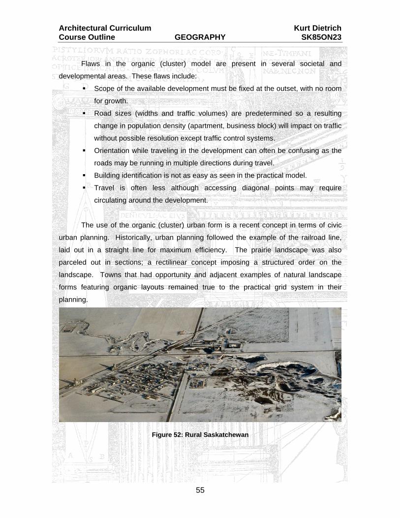
Flaws in the organic (cluster) model are present in several societal and
developmental areas. These flaws include:
Scope of the available development must be fixed at the outset, with no room
for growth.
Road sizes (widths and traffic volumes) are predetermined so a resulting
change in population density (apartment, business block) will impact on traffic
without possible resolution except traffic control systems.
Orientation while traveling in the development can often be confusing as the
roads may be running in multiple directions during travel.
Building identification is not as easy as seen in the practical model.
Travel is often less although accessing diagonal points may require
circulating around the development.
The use of the organic (cluster) urban form is a recent concept in terms of civic
urban planning. Historically, urban planning followed the example of the railroad line,
laid out in a straight line for maximum efficiency. The prairie landscape was also
parceled out in sections; a rectilinear concept imposing a structured order on the
landscape. Towns that had opportunity and adjacent examples of natural landscape
forms featuring organic layouts remained true to the practical grid system in their
planning.
Figure 52: Rural Saskatchewan

Architectural Curriculum Kurt Dietrich Course Outline GEOGRAPHY SK85ON23
56
The two methods of urban planning strategies can be used together, recognizing
the positive and negative influences they both bring to the civic environment. The main
concept of urban design in this regard is to provide energy-efficient planning that makes
the best use of available land while providing increased opportunities for architectural
design strategies.
Civic development strategies are governed by each municipality. These
governing bodies have to consider the city as a whole, as well as each individual area,
when developing a master plan for growth and development. In order to provide for an
environmentally and user-friendly development, civic planning should consider:
(1) Concentration: Encourage physically concentrated developments for
quick, easy access to a wide range of activities from the functional (work,
shopping) to recreational. Concentration techniques will also increase the
opportunity to develop mass transit strategies, lessening the use of vehicle
travel and thereby lowering energy use.
(2) Variety: Allow for development of commercial (business, retail),
institutional (schools and churches), as well as residential areas within
each development zone. The requirement to travel is lowered if the
services desired are easily within reach.
(3) Mixed Use Activities: Allow for combinations of live, work, social and
institution environments within each development. A mixed-use area
provides more opportunity for variety and promotes greater concentration.
Figure 53: Carducci & Associates Mixed-Use Proposal (4) Pedestrian Environment: There must be opportunities and direct
pathways for pedestrians to promote bicycle and walking modes of travel,
as opposed to constantly driving around. A pedestrian environment would
require careful design in order to provide sun and wind compensation.
This category is difficult to promote within our local climate.

Architectural Curriculum Kurt Dietrich Course Outline GEOGRAPHY SK85ON23
57
(5) Orientation: Like Section 5.0, Sociology and Architecture, urban
developments need some form of orientation to gain a sense of your
location. This consideration can be satisfied through the use of civic or
local landmarks and clearly identified pathways. This category relates to
the orientation and way-finding chapters of Section 5.0.
(6) Identity: Each development district requires an identity to create a
distinction from surrounding areas. Identity would be in the form of an
image or character style of the area, similar to the reference identity of the
Cathedral area in Regina, using a landmark as the identifier. Identity
allows the inhabitants to be a part of the larger development group, which
in turn provides a sense of belonging. Territory theory stems from the
sense of belonging and being a part of a larger group. These elements, as
discussed relative to architectural design in Section 5.0, also relate to
urban design and planning on a larger scale.
Civic development strategies will provide for urban environments that are both
energy efficient and effective in their use. An efficient, well-used urban area is a vibrant
one, able to withstand changes over time and nature as the city grows. An area or
district that does not resolve these issues will stagnate and eventually deteriorate,
possibly to the point where only massive redevelopment will restore it to a usable state.

Architectural Curriculum Kurt Dietrich Course Outline GEOGRAPHY SK85ON23
58
Criteria for development of an energy-efficient development area include:
Compact land use area creating the least possible spread on the topography.
Minimal urban sprawl, strip mall, or pod development or under-utilized land.
Strong controls on infill properties and new developments.
Closely developed for places of live, work, shopping, recreation, and personal
service (schools, churches).
Well-developed mass transit system to promote its use over the automobile.
Pedestrian and bicycle friendly.
Varied in building type and form to allow a multitude of choices and
opportunities to age in place.
Structures designed to suit solar and climatic conditions.
Green spaces are integrated throughout the community.
Natural drainage is utilized with minimal impact on topography of the original
area.
These criteria cannot likely be applied universally over existing areas in the city.
The concepts noted should be considered as our urban environment grows outward and
changes within, in an effort to improve the civic structure and associated lifestyles that
we can choose to live.

Architectural Curriculum Kurt Dietrich Course Outline GEOGRAPHY SK85ON23
59
NEW TEXT DEFINITIONS: {A listing of new architectural definitions provided by this component}
Architectural Curriculum Kurt Dietrich Course Outline GEOGRAPHY SK85ON23
60
APPENDIX 'A'
List of Images

Architectural Curriculum Kurt Dietrich Course Outline GEOGRAPHY SK85ON23
61
Reference tags:
A : Photo by Author
B : Buildings that Changed the World
C : Cost Effective Site Planning
D : Architecture: From Pre-History to Post-Modernism
T : The City Shaped
U : Urban Planning and Design Criteria
V : Vitruvius: 10 books on Architecture
Number Name Reference Page Cover City of Regina A ---
1 Boboli Gardens, Florence, Italy A ---
2 Los Angeles Development T 12
3 Great Smokey Mountains, North Carolina
Internet Image ---
4 Landscaping and Climate Internet Image ----
5 Jasper, Alberta A ---
6 Stonehenge, Salisbury Plain, England B 10
7 G. Pompidou Centre, Paris B
8 Kaufmann House, Racine, Wisconsin (Fallingwater) B 159
9 Kaufmann House, Racine, Wisconsin (Fallingwater) B 159
10 Lac Biernsee, Interlaken, Switzerland A ---
11 Museum of Civilization
12 Tuscan Landscape, Florence, Italy
A ---
13 Lumsden, Saskatchewan A ---
14 Saskatchewan Map www.gov.sk.ca ---
15 South-West Saskatchewan Topography A ---
16 Raindrop Erosion Internet Image ---
17 Slope Types U 113
18 Sheet Erosion A ---
19 Landscape Slope Elements A ---
20 Hillside Retaining Wall A ---
21 Roman Orientation V 230
22 Orientation Considerations V 230
23 Orientation and Landscaping C 41
24 Place des Vosges, Paris, France A ---
25 Solar Skyspace U 123
Altitude / Azimuth Locations Internet Image ---
26 Regina Altitude / Azimuth Diagrams Author ---
27 Solar Considerations U 121

Architectural Curriculum Kurt Dietrich Course Outline GEOGRAPHY SK85ON23
62
28 Scarth Street Environment A ---
29 St. Peter's Square, Rome D 343
30 Prairie Landscape A ---
31 Vitruvian Wind Diagram V 166
32 Wind Orientation C 46
33 Eco-Tower, Architecture Magazine Dec. 2002 Edition 53
34 Wind Tunnel Testing Internet Image ---
35 Primary Wind Control C 47
36 Landform and Landscaping C 41
37 Cooling Effects C 47
38 Lakeridge Subdivision, Regina, Sask. A ---
39 Queen Elizabeth Court, Regina, Sask A ---
40 Exterior Fountain, Sask. Power Corporation, Regina A ---
41 Three City Planning Models T 15
42 Palmanova, Italy T 19
43 The Radiant City (Modified Image) Internet Image ---
44 The City of London D. Brown ---
45 Karlsruhe, Germany T 188
46 North-West Regina A ---
47 Scarth Street, Regina A ---
48 Regina City Map www.regina.ca ---
49 City of Regina Downtown Satellite Image www.maps.google.ca ---
50 Organic Subdivision
C 107
51 Cluster Groupings
C 55
52 Rural Saskatchewan
A ---
53 Mixed Use Development Character Sketch
Internet Image ---

Architectural Curriculum Kurt Dietrich Course Outline GEOGRAPHY SK85ON23
63
APPENDIX 'B'
Bibliography

Architectural Curriculum Kurt Dietrich Course Outline GEOGRAPHY SK85ON23
64
DeChiara, Joseph and Koppelman, Lee
Urban Planning and Design Criteria
New York, NY, USA; Van Nostrand Reinhold Co. Inc., 1982
Environment Canada, Lands Directorate
Planning Land to Conserve Energy
Ottawa, Ontario; Land Use in Canada Series, No. 25, 1982
Kostof, Spiro
The City Shaped: Urban Patterns and Meanings through History
London, England; Thames and Hudson Ltd., 1991
Lynch, Kevin
The Image of the City Cambridge, Mass. USA; The MIT Press, 1960
National Association of House Builders
Cost Effective Site Planning
Washington, DC, USA, 1976
Norberg-Schulz, Christian
Genius Loci: Towards a Phenomenology of Architecture (Copied on file in Author's archives)
Rowland, Ingrid D. and Thomas Noble Howe
Vitruvius – Ten Books on Architecture New York, USA; Cambridge University Press, 1999