Embed Size (px)
Citation preview
Maine Department of Environmental Protection VRMP 2012 Data Report, Section 5-8
Presumpscot River – Presumpscot River Watch Page 1 of 15
Section 5-8
Presumpscot River & Tributaries (Presumpscot River Watch)
Refer to Chapter 4 of this document for information about sampling methods, sampling sites, and quality assurance.
Overview
Presumpscot River Watch (PRW), incorporated as a not-for-profit organization in 1989, works to
preserve and improve the health of the Presumpscot River and its tributaries. The mission of the PRW is
to preserve and improve the health of the Presumpscot River watershed by scientific monitoring of water
quality and sharing data to increase awareness of the condition of the river. PRW’s commitment is
primarily accomplished through a seasonal (summer) volunteer water quality monitoring program that
enhances public awareness of river water quality in the Presumpscot River watershed. The data generated
from the monitoring program also serve other purposes: (1) verification of State water quality standards;
(2) identification of specific problem areas; (3) establishment of baseline water quality monitoring data;
and (4) use of water quality monitoring results by other organizations.
The Presumpscot River originates at Sebago Lake Basin and flows approximately 25 miles (40 km) to the
Atlantic Ocean (Casco Bay) through Cumberland County, Maine. The Presumpscot River contributes the
largest freshwater input into Casco Bay, draining approximately 648 square miles. The Presumpscot
watershed below Sebago Lake is slightly more than 200 square miles. Nine dams, seven of which are
used to generate hydroelectric power, create impoundment and associated tailwater habitats. The
uppermost dam is located at the Sebago Lake outlet, whereas the lowermost dam is located at the SAPPI
Mill in Westbrook. Major tributaries to the Presumpscot River include the Pleasant River, Little River,
and the Piscataqua River; minor tributaries include Otter Brook, Nason Brook, Black Brook, Colley
Wright Brook, Inkhorn Brook, and Mill Brook. Highland Lake and Forest Lake are the primary lakes in
the Presumpscot River watershed; Mill Brook and the Piscataqua River, respectively, connect them to the
main stem of the Presumpscot River. Windham, Gorham, Westbrook, Cumberland, Falmouth, and
Portland represent primary municipalities in the Presumpscot River watershed, and are characterized by
multiple land uses. Urban areas include residential and commercial dwellings, commercial businesses,
light industry, and water and wastewater treatment plants. Westbrook and Portland contribute combined
sewer overflow (CSO) discharge to the Presumpscot River below Saccarappa Falls. The SAPPI paper mill
is located in Westbrook. Agricultural practices such as row crop and pasture constitute the agricultural
land use component, whereas mixed deciduous and coniferous forest comprise the forest component.
According to Maine’s statutory Water Classification System, the Presumpscot River Basin has
designations listed below. 1
Presumpscot River, main stem.
o From the outlet of Sebago Lake to the confluence with the Pleasant River – Class A. (Note:
Dundee Pond is a great pond, classified GPA)
o From the confluence with the Pleasant River to Saccarappa Falls – Class B.
1 http://www.mainelegislature.org/legis/statutes/38/title38sec467.html

Maine Department of Environmental Protection VRMP 2012 Data Report, Section 5-8
Presumpscot River – Presumpscot River Watch Page 2 of 15
o From the Saccarappa Falls to tidewater – Class C.
o Below head-of-tide – Class SC.
Presumpscot River tributaries below Sebago Lake – Class B.
Methods
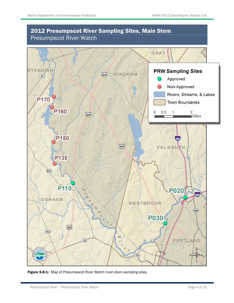
The volunteers monitor the Presumpscot River annually. There are twenty-five monitoring sites in the
watershed (Table 5-8-1). Although PRW’s goal is to monitor all sites each year, they are not always able
to do so. In 2012 they sampled 21 sites, 16 of which are VMRP approved sites. (Figures 5-8-1 through 5-
8-6). All stations are above the head-of-tide at Presumpscot Falls.
Monitoring was conducted between 5:41 and 8:40 AM, every two weeks from May 19th through August
25th. At most of the sites, the monitors take measurements of dissolved oxygen and temperature using
either YSI 550A or YSI 85 meters. At two sites, dissolved oxygen was measured with a LaMotte
dissolved oxygen titration kit and temperature was measured with a handheld thermometer. Grab samples
were collected for E. coli bacteria and transported to the PRW office for analysis using IDEXX Quanti-
Tray 2000 method. Air temperature, weather conditions, and water appearance were recorded.
Table 5-8-1. Presumpscot River Watch sampling sites, ordered from upstream down for the main stem and the
same for the tributaries at their confluence with the Presumpscot River (*indicates non-approved sites).
Site ID Organization Site Code Sample Location Class
Presumpscot River-R202-VRMP* P170 North Gorham Dam A
Presumpscot River-R195-VRMP* P160 Dundee Pond Headwater A
Presumpscot River-R166-PRW * P150 Covered Bridge A
Presumpscot River-R157-PRW * P135 Park in Gambo B
Presumpscot River-R133-VRMP P110 Presumpscot River B
Presumpscot River-R47-VRMP P030 Presumpscot River C
Presumpscot River-R24-VRMP P020 Blackstrap Road C
Otter Brook-ROT06-VRMP OB010 Otter Brook B
Nason Brook-RNS11-VRMP N010 Nason Brook B
Baker Brook-RPLBK17-VRMP BB010 Baker Brook B
Ditch Brook-RPL00-VRMP DB010 Ditch Brook B
Pleasant River -RPL47-VRMP PL040 Route 302 B
Pleasant River-RPL06-VRMP PL010 Lovett Bridge B
Black Brook-RBK05-VRMP BL010 Black Brook B

Maine Department of Environmental Protection VRMP 2012 Data Report, Section 5-8
Presumpscot River – Presumpscot River Watch Page 3 of 15
Table 5-8-1. (Continued) Presumpscot River Watch sampling sites, ordered from upstream down for the main
stem and the same for the tributaries at their confluence with the Presumpscot River (*indicates non-approved
sites).
Site ID Organization Site Code Sample Location Class
Colley Wright Brook-RCW28-VRMP CW020 Colley Wright Brook B
Colley Wright Brook-RCW10-VRMP CW010 Colley Wright Brook B
Douglas Brook-RLTNBDG20-VRMP DG010 Douglas Brook B
Little River-L050-VRMP L050 Little River B
Little River-RLT15-VRMP L020 Route 202/4 B
Little River-RLT08-PRW * L010 Route 237 B
Inkhorn Brook-RIK05-VRMP IN010 Inkhorn Brook B
Mill Brook-RML63-VRMP M030 Below Highland Lake B
Mill Brook-RML01-VRMP M010 Bridge Street B
E. Branch Piscataqua River-RPSEB05-VRMP PI010 Falmouth Road B
Piscataqua River-RPS12-VRMP PI020 Leighton Road B
Maine Department of Environmental Protection VRMP 2012 Data Report, Section 5-8
Presumpscot River – Presumpscot River Watch Page 4 of 15
2012 Presumpscot River Sampling Sites, Main Stem
Presumpscot River Watch
Figure 5-8-1: Map of Presumpscot River Watch main stem sampling sites.
Maine Department of Environmental Protection VRMP 2012 Data Report, Section 5-8
Presumpscot River – Presumpscot River Watch Page 5 of 15
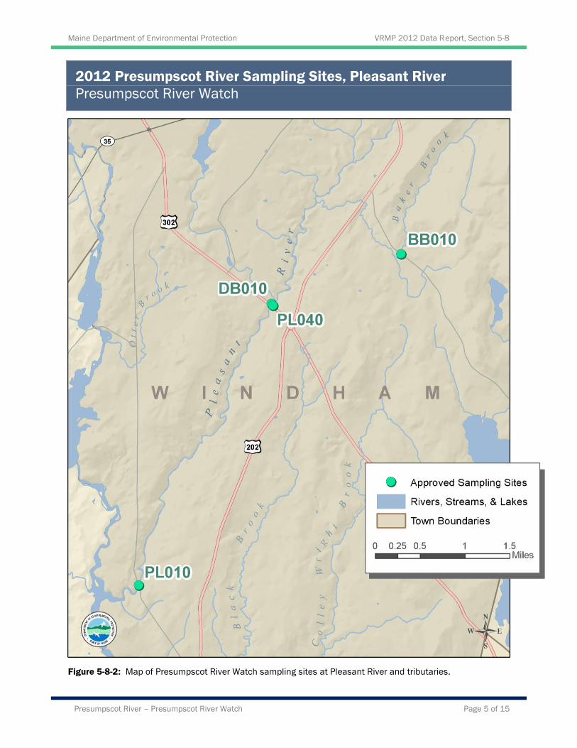
2012 Presumpscot River Sampling Sites, Pleasant River
Presumpscot River Watch
Figure 5-8-2: Map of Presumpscot River Watch sampling sites at Pleasant River and tributaries.
Maine Department of Environmental Protection VRMP 2012 Data Report, Section 5-8
Presumpscot River – Presumpscot River Watch Page 6 of 15
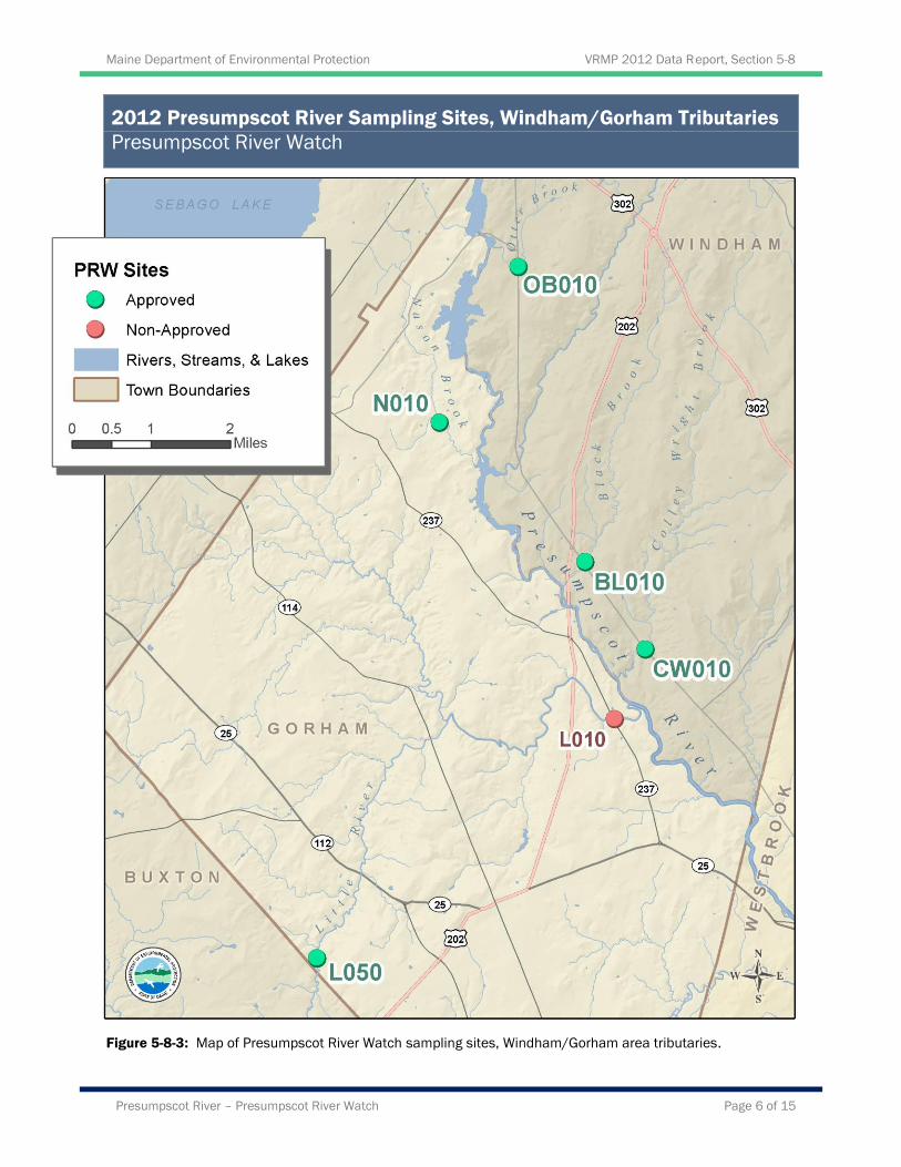
2012 Presumpscot River Sampling Sites, Windham/Gorham Tributaries
Presumpscot River Watch
Figure 5-8-3: Map of Presumpscot River Watch sampling sites, Windham/Gorham area tributaries.
Maine Department of Environmental Protection VRMP 2012 Data Report, Section 5-8
Presumpscot River – Presumpscot River Watch Page 7 of 15
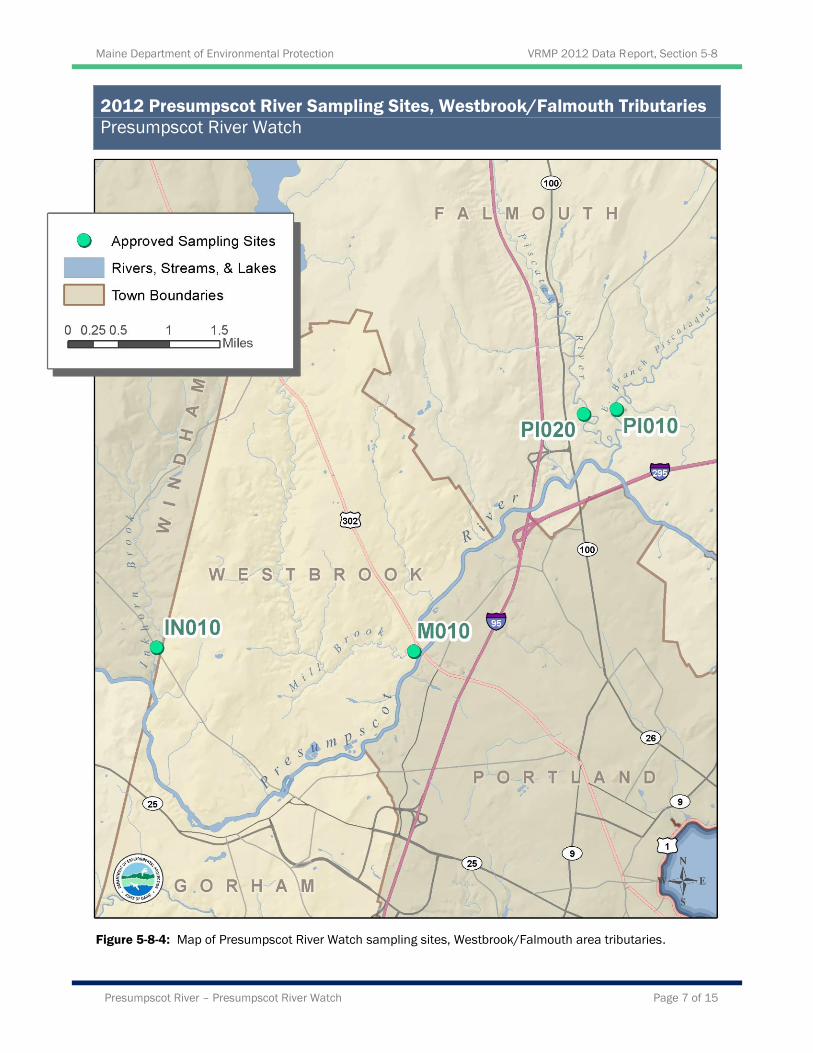
2012 Presumpscot River Sampling Sites, Westbrook/Falmouth Tributaries
Presumpscot River Watch
Figure 5-8-4: Map of Presumpscot River Watch sampling sites, Westbrook/Falmouth area tributaries.
Maine Department of Environmental Protection VRMP 2012 Data Report, Section 5-8
Presumpscot River – Presumpscot River Watch Page 8 of 15
Results
For the purpose of discussion, the sampling stations were divided into Presumpscot River main stem (site
code P170 – P020), and the tributaries collectively. Refer to Appendices A-1 and A-2 in discussion of
individual site data and trends, as well as graphed data (Figures 5-8-8 through 5-8-23), at the end of this
section of the report.
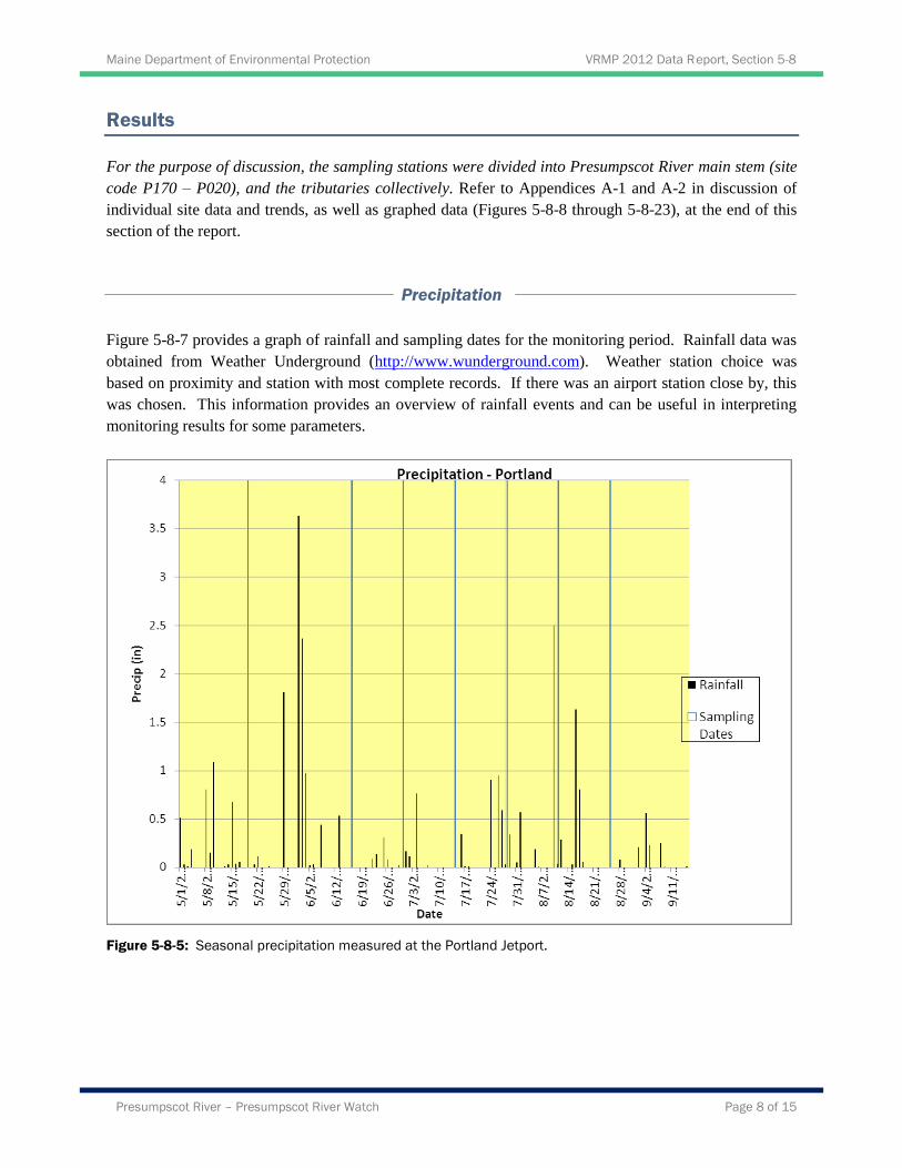
Precipitation
Figure 5-8-7 provides a graph of rainfall and sampling dates for the monitoring period. Rainfall data was
obtained from Weather Underground (http://www.wunderground.com). Weather station choice was
based on proximity and station with most complete records. If there was an airport station close by, this
was chosen. This information provides an overview of rainfall events and can be useful in interpreting
monitoring results for some parameters.
Figure 5-8-5: Seasonal precipitation measured at the Portland Jetport.
Maine Department of Environmental Protection VRMP 2012 Data Report, Section 5-8
Presumpscot River – Presumpscot River Watch Page 9 of 15
Dissolved Oxygen
Presumpscot Main stem:
Dissolved oxygen (DO) was measured 5-7 times throughout the season at each of the seven main stem
sampling sites (Table 5-8-2 and 5-8-3). All DO measurements except P030 on August 11th were taken
before 8:00 AM, the recommended period to measure diurnal low concentrations. Dissolved oxygen
percent saturation was measured at all seven main stem sites. At P030 and P020 (dam impoundments),
measurements were made at 1-meter increments in order to determine if the impoundment developed
thermal stratification or if the water was fully mixed. At both sites, the water was fully mixed and
parameters were averaged for the day (see Appendix A-1). Class A and B criteria for DO are a minimum
of 7.0 mg/l or 75% saturation. Class C criteria for dissolved oxygen are a minimum of 5.0 mg/l or 60 %
saturation. To meet water quality criteria, both concentration and saturation standards must be met.
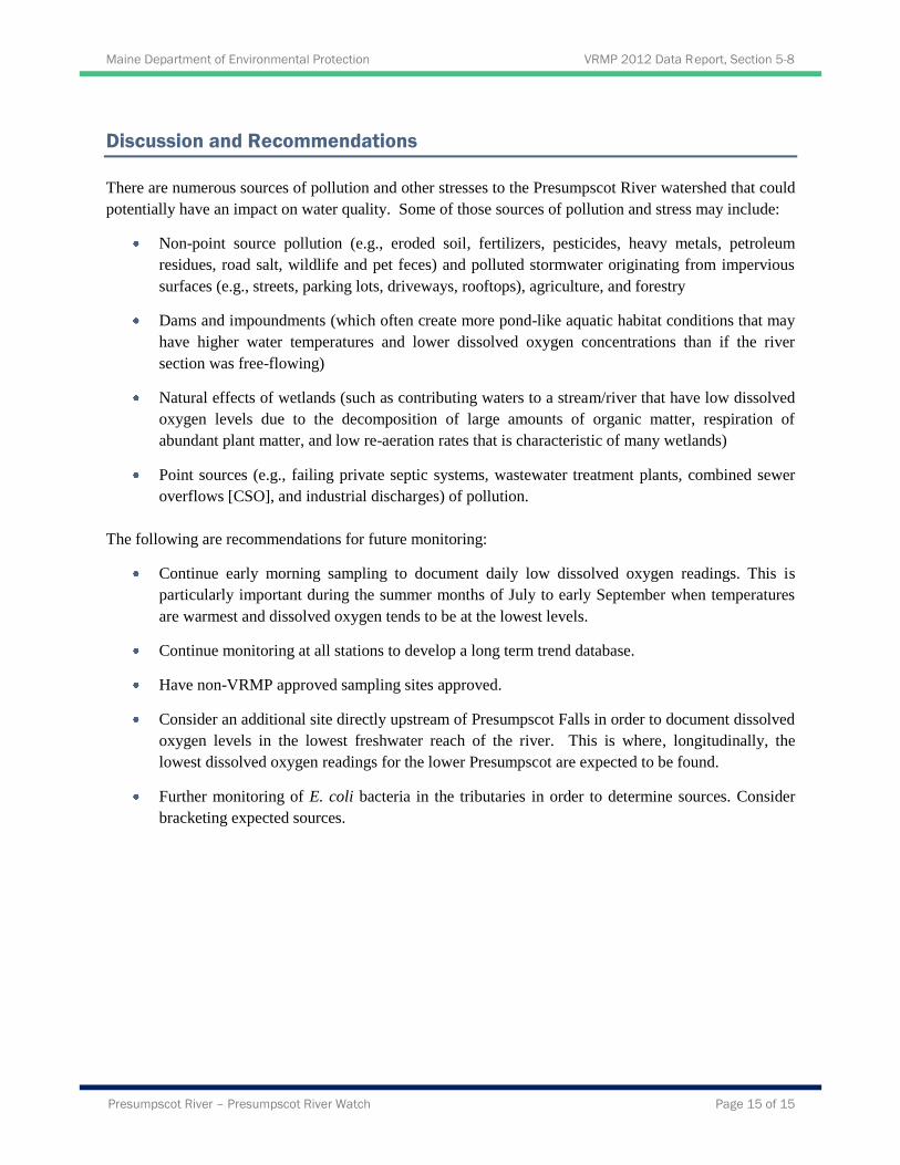
Dissolved oxygen concentrations in the main stem of the river ranged from 6.5 to 10.2 mg/l and from 75.7
to 107.4 percent saturation. All three Class A sampling sites (P170, P160, and P150) met both criteria.
Both Class B sampling sites (P135, P110) met Class B criterion of 7.0 mg/l, except for June 30th at P135
where the DO concentration was 6.5 mg/l. Sites P170, P160, P150, and P135 are non-approved sites
because the measurements were taken near the shore which could skew the readings. Dissolved oxygen
levels never dropped below the Class C instantaneous criteria of 5.0 mg/L or 60 % saturation in the lower
Presumpscot River (P030 and P020).
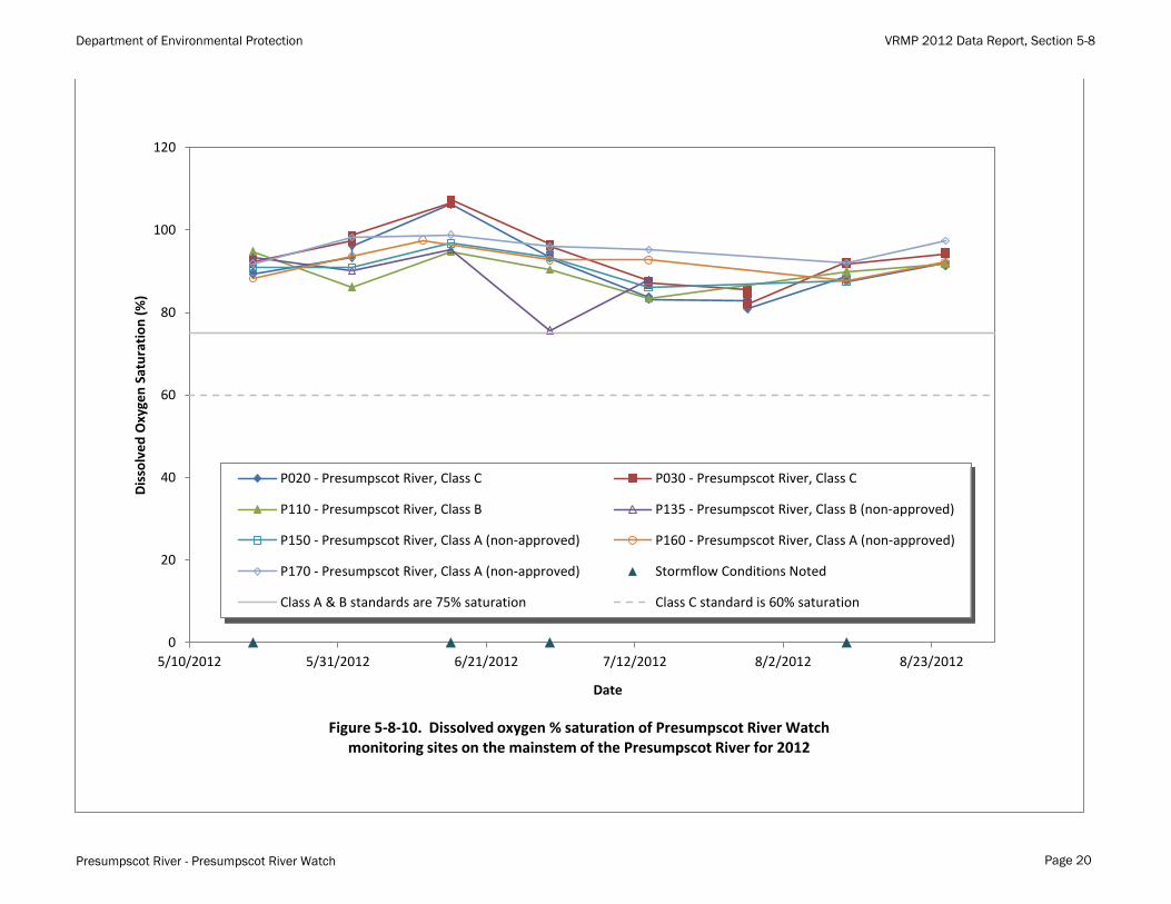
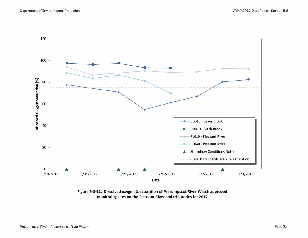
Presumpscot Tributaries:
Dissolved oxygen (DO) concentration was measured 5-8 times at each of the fourteen sampling sites on
the five major Presumpscot tributaries and their feeder streams (Table 5-8-2 and Table 5-8-3). Ninety-
nine percent (166 out of 168) of the DO measurements were taken before 8:00 AM, the recommended
period to measure diurnal low concentrations. Class B criteria for dissolved oxygen are a minimum of 7.0
mg/l or 75% saturation. To meet water quality criteria, both concentration and saturation standards must
be met.
Nine out of fourteen sample sites had DO measurements below the Class B instantaneous criteria of 7.0
mg/L and 75 % saturation. Of the 168 readings recorded throughout the season, 149 (or 89%) met
criteria. This was an improvement over 2011.

Maine Department of Environmental Protection VRMP 2012 Data Report, Section 5-8
Presumpscot River – Presumpscot River Watch Page 10 of 15
Table 5-8-2: A summary of minimum, maximum, and average dissolved oxygen concentration values (mg/l) at
Presumpscot River Watch monitoring sites.
Site Approved Site # of Samples Minimum Value Maximum Value Average Value
P170 N 7 7.7 9.4 8.5
P160 N 7 7.2 9.4 8.2
P150 N 6 6.7 9.2 7.9
P135 N 3 6.5 9.3 7.6
P110 Y 7 7.1 9.3 7.9
P030* Y 26 7.2 10.2 8.4
P020* Y 24 6.8 10.1 8.0
OB010 Y 3 1.6 3.3 2.3
N010 Y 3 7.7 9.3 8.4
BB010 Y 6 5.0 7.9 6.5
DB010 Y 3 8.0 8.9 8.3
PL040 Y 3 6.2 8.3 7.2
PL010 Y 7 7.8 9.4 8.2
BL010 Y 7 6.5 8.6 7.7
CW010 Y 8 4.4 9.6 8.0
L050 Y 7 6.7 8.9 7.6
L010 N 6 7.8 9.6 8.7
IN010 Y 8 5.6 8.2 7.0
M010 Y 8 7.0 9.7 8.1
PI010 Y 7 6.5 9.6 7.8
PI020 Y 7 8.2 10.4 9.2
* Depth profile measurements made during seven site visits. Average Value was determined by first averaging
the profiles before averaging of each sampling day.
Maine Department of Environmental Protection VRMP 2012 Data Report, Section 5-8
Presumpscot River – Presumpscot River Watch Page 11 of 15
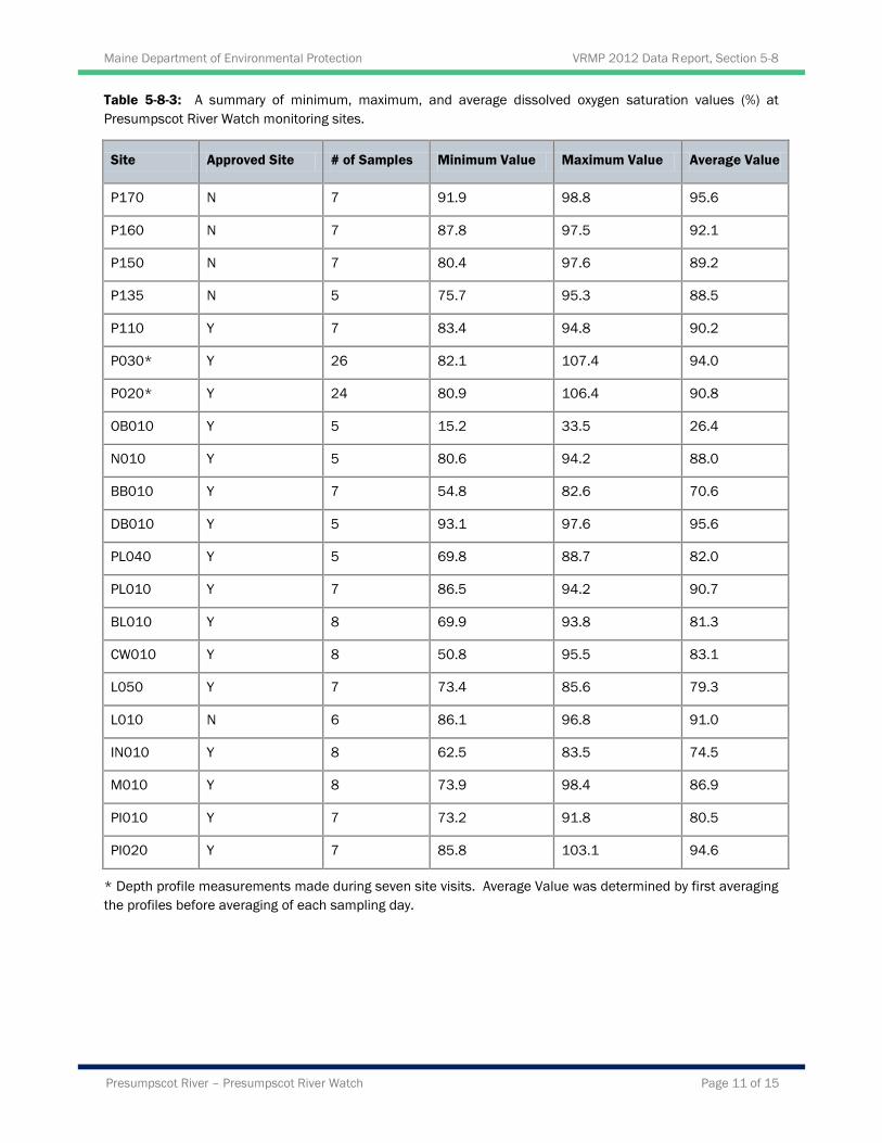
Table 5-8-3: A summary of minimum, maximum, and average dissolved oxygen saturation values (%) at
Presumpscot River Watch monitoring sites.
Site Approved Site # of Samples Minimum Value Maximum Value Average Value
P170 N 7 91.9 98.8 95.6
P160 N 7 87.8 97.5 92.1
P150 N 7 80.4 97.6 89.2
P135 N 5 75.7 95.3 88.5
P110 Y 7 83.4 94.8 90.2
P030* Y 26 82.1 107.4 94.0
P020* Y 24 80.9 106.4 90.8
OB010 Y 5 15.2 33.5 26.4
N010 Y 5 80.6 94.2 88.0
BB010 Y 7 54.8 82.6 70.6
DB010 Y 5 93.1 97.6 95.6
PL040 Y 5 69.8 88.7 82.0
PL010 Y 7 86.5 94.2 90.7
BL010 Y 8 69.9 93.8 81.3
CW010 Y 8 50.8 95.5 83.1
L050 Y 7 73.4 85.6 79.3
L010 N 6 86.1 96.8 91.0
IN010 Y 8 62.5 83.5 74.5
M010 Y 8 73.9 98.4 86.9
PI010 Y 7 73.2 91.8 80.5
PI020 Y 7 85.8 103.1 94.6
* Depth profile measurements made during seven site visits. Average Value was determined by first averaging
the profiles before averaging of each sampling day.

Maine Department of Environmental Protection VRMP 2012 Data Report, Section 5-8
Presumpscot River – Presumpscot River Watch Page 12 of 15
Water Temperature
All Sample Sites:
Temperature was measured 5-7 times at all seven of the main stem sampling sites and 5-8 times at the
fourteen tributary sites (Table 5-8-4). All temperature readings were taken before 8:40 AM. Water
temperatures varied over time at all sites, increasing as the spring shifted into summer. Main stem water
temperatures are generally higher than tributaries. The average July/August water temperature for the
main stem sample sites were 24.7°C/24.4°C. The average July/August water temperatures for the
tributaries were 18.9°C/ 18.8°C. The difference between the main stem and the tributaries is due to
resident time within dam impoundments and lack of tree cover across the width of the channel.
Table 5-8-4: A summary of minimum, maximum, and average water temperature values (°C) at Presumpscot
River Watch monitoring sites.
Site Approved Site # of Samples Minimum Value Maximum Value Average Value
P170 N 7 15.9 26.2 21.7
P160 N 7 15.5 26.1 21.5
P150 N 7 15.2 25.4 21.4
P135 N 5 16.6 25.8 20.5
P110 Y 7 16.3 25.6 22.3
P030* Y 26 15.9 25.1 21.3
P020* Y 24 15.9 25.2 21.7
OB010 Y 5 13.8 19.0 16.5
N010 Y 5 11.0 17.5 14.4
BB010 Y 7 15.2 20.4 18.6
DB010 Y 5 16.7 23.0 20.0
PL040 Y 5 14.3 21.2 17.9
PL010 Y 7 15.7 23.0 20.3
BL010 Y 8 11.6 20.2 17.2
CW010 Y 8 12.6 22.8 17.8
L050 Y 7 13.5 19.9 17.7
L010 N 6 13.0 20.6 17.5
IN010 Y 8 13.0 21.1 18.3
M010 Y 8 14.0 21.3 18.8
PI010 Y 7 13.3 21.5 18.3
PI020 Y 7 13.0 19.6 17.1
* Depth profile measurements made during seven site visits. Average Value was determined by first averaging
the profiles before averaging of each sampling day.
Maine Department of Environmental Protection VRMP 2012 Data Report, Section 5-8
Presumpscot River – Presumpscot River Watch Page 13 of 15
Bacteria
Presumpscot Main stem:
Escherichia coli bacteria were sampled 5-8 times at each of the seven main stem sampling sites (Table 5-
8-5). E. coli bacteria are used as the indicator organism for freshwaters. While this type of bacteria is not
a pathogen, its presence in the water may indicate the presence of other organisms including bacteria and
viruses that can cause gastrointestinal illnesses. Typically, observed high bacterial levels are often
associated with stormwater runoff and/or combined sewer overflows. Most of the E. coli samples dates
did not have significant rainfall events within two days of sampling and would not be expected to be
influenced by stormwater runoff. Two dates were the exception. The day before the July 28th sampling
there was 0.6 inches of rain measured at the Portland Jetport (Figure 5-8-7) with a total of 2.48 inches
within the previous four days. Samples taken on August 11th occurred the day after 2.5 inches of rain
measured at the Jetport.
Class B criteria for bacteria are as follows: “Between May 15th and September 30
th, the number of
Escherichia Coli of human and domestic origin shall not exceed a geometric mean of 64/100 ml
(milliliters) or an instantaneous level of 236/100 ml.” Class C criteria are: “Between May 15th and
September 30th, the number of Escherichia Coli of human and domestic origin shall not exceed a
geometric mean of 126/100 ml (milliliters) or an instantaneous level of 236/100 ml.” Geometric means
are calculated instead of averages because measures like bacteria often have a few very large values that
strongly influence the mean and make it a poor predictor.
The main stem of the Presumpscot had violation of the bacteria standard for instantaneous readings at two
of the seven sites on July 28th and six of the seven sampling sites on August 11
th. This suggests a high
probability that the exceedance is due to stormwater runoff. No main stem sampling site exceeded the
geometric mean criterion for either Class B or Class C bacteria standard.
Presumpscot Tributaries:
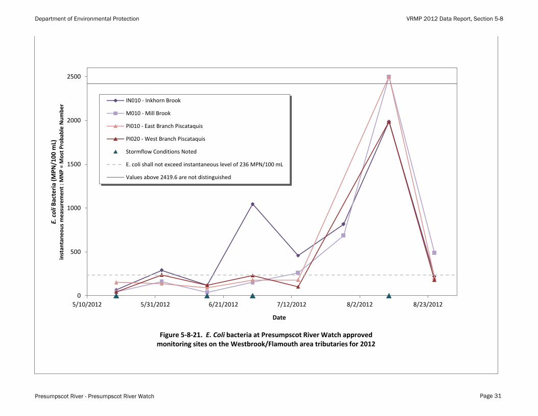
E. coli bacteria were sampled 5-8 times at each of the fourteen tributary sampling sites (Table 5-8-5). E.
coli bacteria are used as the indicator organism for freshwaters. While this type of bacteria is not a
pathogen, its presence in the water may indicate the presence of other organisms including bacteria and
viruses that can cause gastrointestinal illnesses. Most of the E. coli samples dates did not have significant
rainfall events within two days of sampling and would not be expected to be influenced by stormwater
runoff; two dates were the exception. The day before the July 28th sampling there was 0.6 inches of rain
measured at the Portland Jetport (Figure 5-9-7) and a total of 2.48 inches within the previous four days.
Samples taken on August 11th occurred the day after there was 2.5 inches of rain measured at the Jetport.
Class B criteria for bacteria are as follows: “Between May 15th and September 30
th, the number of
Escherichia Coli of human and domestic origin shall not exceed a geometric mean of 64/100 ml
(milliliters) or an instantaneous level of 236/100 ml.”
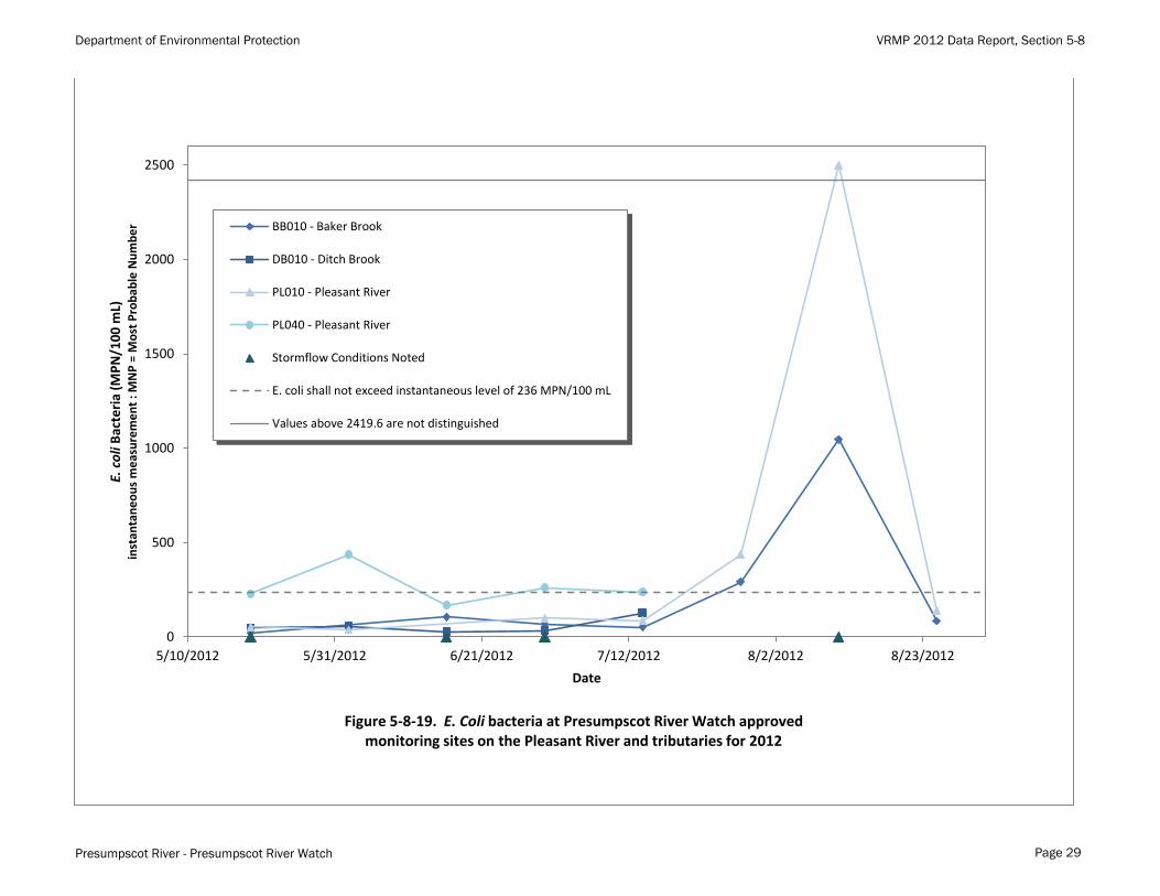
Twelve of fourteen tributary sampling sites violated Class B geometric mean criterion of 64/100 ml and
the instantaneous criterion of 236/100 ml. Examining the data in Appendix A-1 the 2.5 inch rainfall event
on August 10th and the resulting runoff generated six of the seven maximum values that exceeded the test
Maine Department of Environmental Protection VRMP 2012 Data Report, Section 5-8
Presumpscot River – Presumpscot River Watch Page 14 of 15
limit of 2420/100 ml. If the August 11th data were removed from the analysis, ten of the fourteen sites
would still violate Class B criteria.
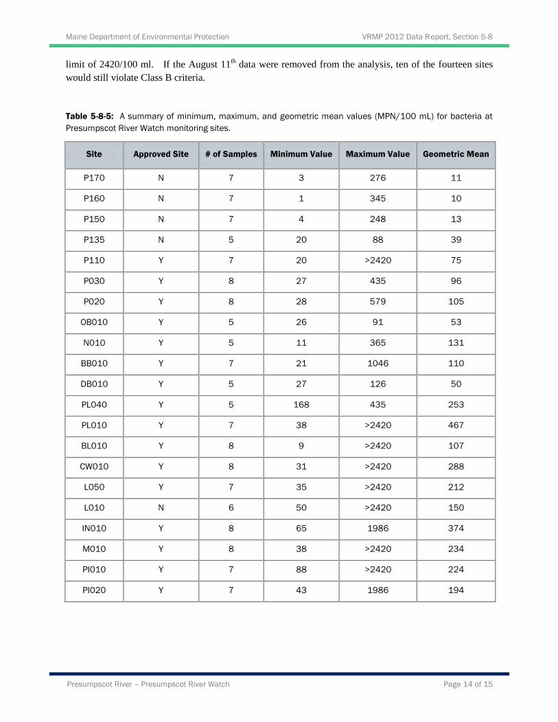
Table 5-8-5: A summary of minimum, maximum, and geometric mean values (MPN/100 mL) for bacteria at
Presumpscot River Watch monitoring sites.
Site Approved Site # of Samples Minimum Value Maximum Value Geometric Mean
P170 N 7 3 276 11
P160 N 7 1 345 10
P150 N 7 4 248 13
P135 N 5 20 88 39
P110 Y 7 20 >2420 75
P030 Y 8 27 435 96
P020 Y 8 28 579 105
OB010 Y 5 26 91 53
N010 Y 5 11 365 131
BB010 Y 7 21 1046 110
DB010 Y 5 27 126 50
PL040 Y 5 168 435 253
PL010 Y 7 38 >2420 467
BL010 Y 8 9 >2420 107
CW010 Y 8 31 >2420 288
L050 Y 7 35 >2420 212
L010 N 6 50 >2420 150
IN010 Y 8 65 1986 374
M010 Y 8 38 >2420 234
PI010 Y 7 88 >2420 224
PI020 Y 7 43 1986 194
Maine Department of Environmental Protection VRMP 2012 Data Report, Section 5-8
Presumpscot River – Presumpscot River Watch Page 15 of 15
Discussion and Recommendations
There are numerous sources of pollution and other stresses to the Presumpscot River watershed that could
potentially have an impact on water quality. Some of those sources of pollution and stress may include:
Non-point source pollution (e.g., eroded soil, fertilizers, pesticides, heavy metals, petroleum
residues, road salt, wildlife and pet feces) and polluted stormwater originating from impervious
surfaces (e.g., streets, parking lots, driveways, rooftops), agriculture, and forestry
Dams and impoundments (which often create more pond-like aquatic habitat conditions that may
have higher water temperatures and lower dissolved oxygen concentrations than if the river
section was free-flowing)
Natural effects of wetlands (such as contributing waters to a stream/river that have low dissolved
oxygen levels due to the decomposition of large amounts of organic matter, respiration of
abundant plant matter, and low re-aeration rates that is characteristic of many wetlands)
Point sources (e.g., failing private septic systems, wastewater treatment plants, combined sewer
overflows [CSO], and industrial discharges) of pollution.
The following are recommendations for future monitoring:
Continue early morning sampling to document daily low dissolved oxygen readings. This is
particularly important during the summer months of July to early September when temperatures
are warmest and dissolved oxygen tends to be at the lowest levels.
Continue monitoring at all stations to develop a long term trend database.
Have non-VRMP approved sampling sites approved.
Consider an additional site directly upstream of Presumpscot Falls in order to document dissolved
oxygen levels in the lowest freshwater reach of the river. This is where, longitudinally, the
lowest dissolved oxygen readings for the lower Presumpscot are expected to be found.
Further monitoring of E. coli bacteria in the tributaries in order to determine sources. Consider
bracketing expected sources.

Department of Environmental Protection VRMP 2012 Data Report, Section 5-8
Presumpscot River - Presumpscot River Watch
0
2
4
6
8
10
12
5/10/2012 5/31/2012 6/21/2012 7/12/2012 8/2/2012 8/23/2012
Dis
solv
ed
Oxy
gen
(m
g/L)
Date
P020 - Presumpscot River, Class C P030 - Presumpscot River, Class C
P110 - Presumpscot River, Class B P135 - Presumpscot River, Class B (non-approved)
P150 - Presumpscot River, Class A (non-approved) P160 - Presumpscot River, Class A (non-approved)
P170 - Presumpscot River, Class A (non-approved) Stormflow Conditions Noted
Class A & B standards are 7 mg/L Class C standard is 5 mg/L
Figure 5-8-6. Dissolved oxygen concentrations of Presumpscot River Watch monitoring sites on the mainstem of the Presumpscot River for 2012
Page 16

Department of Environmental Protection VRMP 2012 Data Report, Section 5-8
Presumpscot River - Presumpscot River Watch
0
1
2
3
4
5
6
7
8
9
10
5/10/2012 5/31/2012 6/21/2012 7/12/2012 8/2/2012 8/23/2012
Dis
solv
ed
Oxy
gen
(m
g/L)
Date
BB010 - Baker Brook
DB010 - Ditch Brook
PL010 - Pleasant River
PL040 - Pleasant River
Stormflow Conditions Noted
Class B standards are 7 mg/L
Figure 5-8-7. Dissolved oxygen concentrations of Presumpscot River Watch approved monitoring sites on the Pleasant River and tributaries for 2012
Page 17

Department of Environmental Protection VRMP 2012 Data Report, Section 5-8
Presumpscot River - Presumpscot River Watch
0
2
4
6
8
10
12
5/10/2012 5/31/2012 6/21/2012 7/12/2012 8/2/2012 8/23/2012
Dis
solv
ed
Oxy
gen
(m
g/L)
Date
BL010 - Black Brook
CW010 - Colley Wright Brook
L010 - Little River (non-approved)
L050 - Little River
N010 - Nason Brook
OB010 - Otter Brook
Stormflow Conditions Noted
Class B standards are 7 mg/L
Figure 5-8-8. Dissolved oxygen concentrations of Presumpscot River Watch monitoring sites on the Windham/Gorham area tributaries for 2012
Page 18

Department of Environmental Protection VRMP 2012 Data Report, Section 5-8
Presumpscot River - Presumpscot River Watch
0
2
4
6
8
10
12
5/10/2012 5/31/2012 6/21/2012 7/12/2012 8/2/2012 8/23/2012
Dis
solv
ed
Oxy
gen
(m
g/L)
Date
IN010 - Inkhorn Brook
M010 - Mill Brook
PI010 - East Branch Piscataquis
PI020 - West Branch Piscataquis
Stormflow Conditions Noted
Class B standards are 7 mg/L
Figure 5-8-9. Dissolved oxygen concentrations of Presumpscot River Watch approved monitoring sites on the Westbrook/Flamouth area tributaries for 2012
Page 19
Department of Environmental Protection VRMP 2012 Data Report, Section 5-8
Presumpscot River - Presumpscot River Watch
0
20
40
60
80
100
120
5/10/2012 5/31/2012 6/21/2012 7/12/2012 8/2/2012 8/23/2012
Dis
solv
ed
Oxy
gen
Sat
ura
tio
n (
%)
Date
P020 - Presumpscot River, Class C P030 - Presumpscot River, Class C
P110 - Presumpscot River, Class B P135 - Presumpscot River, Class B (non-approved)
P150 - Presumpscot River, Class A (non-approved) P160 - Presumpscot River, Class A (non-approved)
P170 - Presumpscot River, Class A (non-approved) Stormflow Conditions Noted
Class A & B standards are 75% saturation Class C standard is 60% saturation
Figure 5-8-10. Dissolved oxygen % saturation of Presumpscot River Watch monitoring sites on the mainstem of the Presumpscot River for 2012
Page 20
Department of Environmental Protection VRMP 2012 Data Report, Section 5-8
Presumpscot River - Presumpscot River Watch
0
20
40
60
80
100
120
5/10/2012 5/31/2012 6/21/2012 7/12/2012 8/2/2012 8/23/2012
Dis
solv
ed
Oxy
gen
Sat
ura
tio
n (
%)
Date
BB010 - Baker Brook
DB010 - Ditch Brook
PL010 - Pleasant River
PL040 - Pleasant River
Stormflow Conditions Noted
Class B standards are 75% saturation
Figure 5-8-11. Dissolved oxygen % saturation of Presumpscot River Watch approved monitoring sites on the Pleasant River and tributaries for 2012
Page 21
Department of Environmental Protection VRMP 2012 Data Report, Section 5-8
Presumpscot River - Presumpscot River Watch
0
20
40
60
80
100
120
5/10/2012 5/31/2012 6/21/2012 7/12/2012 8/2/2012 8/23/2012
Dis
solv
ed
Oxy
gen
Sat
ura
tio
n (
%)
Date
BL010 - Black Brook
CW010 - Colley Wright Brook
L010 - Little River (non-approved)
L050 - Little River
N010 - Nason Brook
OB010 - Otter Brook
Stormflow Conditions Noted
Class B standards are 75% saturation
Figure 5-8-12. Dissolved oxygen % saturation of Presumpscot River Watch monitoring sites on the Windham/Gorham area tributaries for 2012
Page 22
Department of Environmental Protection VRMP 2012 Data Report, Section 5-8
Presumpscot River - Presumpscot River Watch
0
20
40
60
80
100
120
5/10/2012 5/31/2012 6/21/2012 7/12/2012 8/2/2012 8/23/2012
Dis
solv
ed
Oxy
gen
Sat
ura
tio
n (
%)
Date
IN010 - Inkhorn Brook
M010 - Mill Brook
PI010 - East Branch Piscataquis
PI020 - West Branch Piscataquis
Stormflow Conditions Noted
Class B standards are 75% saturation
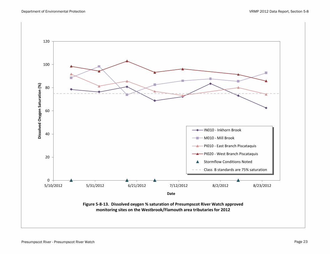
Figure 5-8-13. Dissolved oxygen % saturation of Presumpscot River Watch approved monitoring sites on the Westbrook/Flamouth area tributaries for 2012
Page 23
Department of Environmental Protection VRMP 2012 Data Report, Section 5-8
Presumpscot River - Presumpscot River Watch
0
5
10
15
20
25
30
5/10/2012 5/31/2012 6/21/2012 7/12/2012 8/2/2012 8/23/2012
Wat
er
Tem
pe
ratu
re (
C
)
Date
P020 - Presumpscot River, Class C P030 - Presumpscot River, Class C
P110 - Presumpscot River, Class B P135 - Presumpscot River, Class B (non-approved)
P150 - Presumpscot River, Class A (non-approved) P160 - Presumpscot River, Class A (non-approved)
P170 - Presumpscot River, Class A (non-approved)
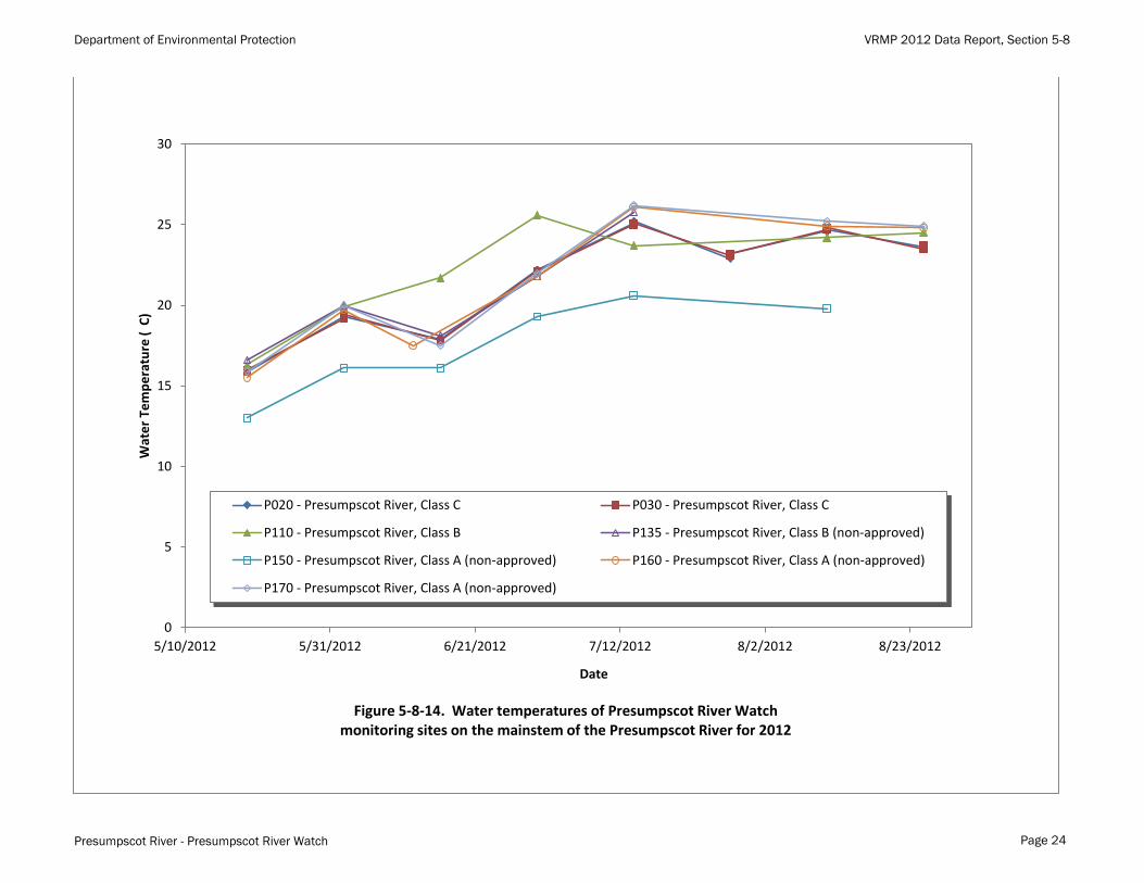
Figure 5-8-14. Water temperatures of Presumpscot River Watch monitoring sites on the mainstem of the Presumpscot River for 2012
Page 24
Department of Environmental Protection VRMP 2012 Data Report, Section 5-8
Presumpscot River - Presumpscot River Watch
0
5
10
15
20
25
5/10/2012 5/31/2012 6/21/2012 7/12/2012 8/2/2012 8/23/2012
Wat
er
Tem
pe
ratu
re (
C
)
Date
BB010 - Baker Brook
DB010 - Ditch Brook
PL010 - Pleasant River
PL040 - Pleasant River
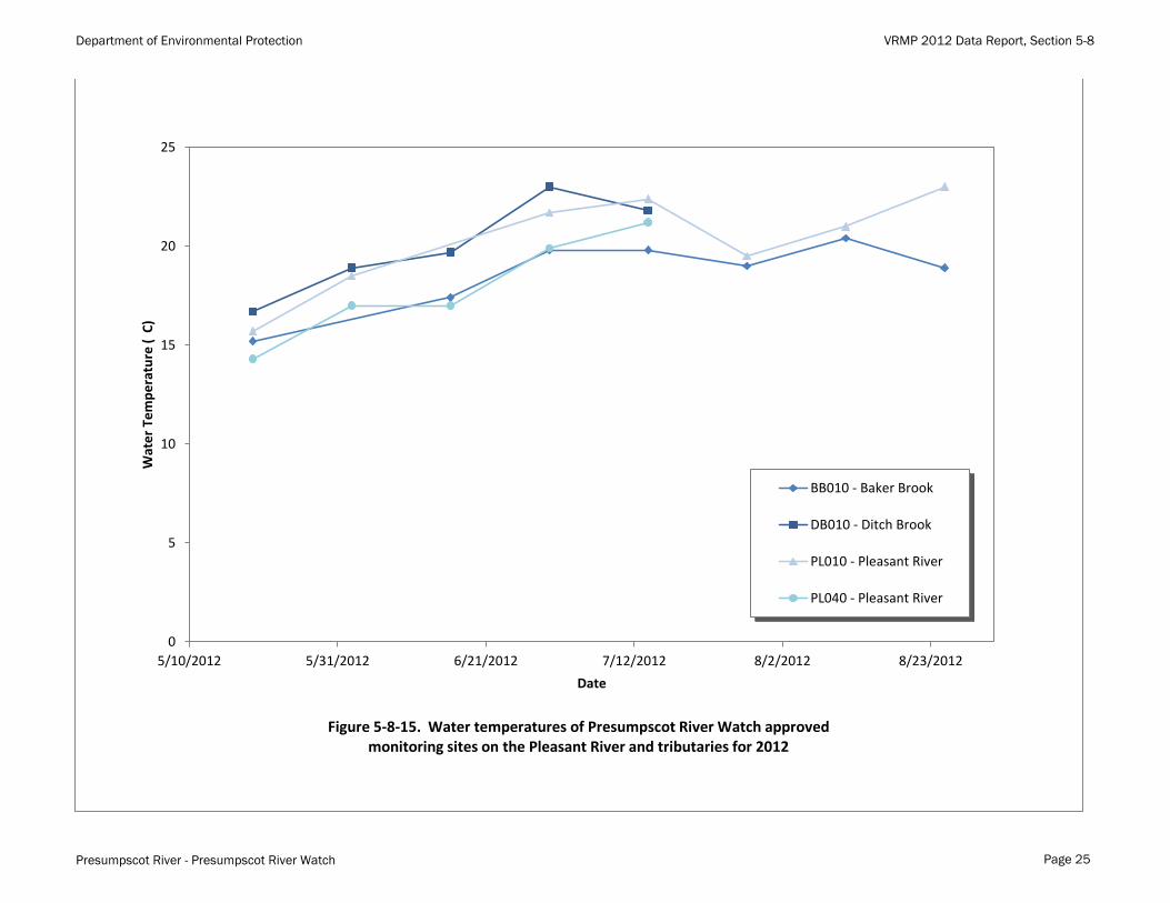
Figure 5-8-15. Water temperatures of Presumpscot River Watch approved monitoring sites on the Pleasant River and tributaries for 2012
Page 25

Department of Environmental Protection VRMP 2012 Data Report, Section 5-8
Presumpscot River - Presumpscot River Watch
0
5
10
15
20
25
5/10/2012 5/31/2012 6/21/2012 7/12/2012 8/2/2012 8/23/2012
Wat
er
Tem
pe
ratu
re (
C
)
Date
BL010 - Black Brook
CW010 - Colley Wright Brook
L010 - Little River (non-approved)
L050 - Little River
N010 - Nason Brook
OB010 - Otter Brook
Figure 5-8-16. Water temperatures of Presumpscot River Watch monitoring sites on the Windham/Gorham area tributaries for 2012
Page 26
Department of Environmental Protection VRMP 2012 Data Report, Section 5-8
Presumpscot River - Presumpscot River Watch
0
5
10
15
20
25
5/10/2012 5/31/2012 6/21/2012 7/12/2012 8/2/2012 8/23/2012
Wat
er
Tem
pe
ratu
re (
C
)
Date
IN010 - Inkhorn Brook
M010 - Mill Brook
PI010 - East Branch Piscataquis
PI020 - West Branch Piscataquis
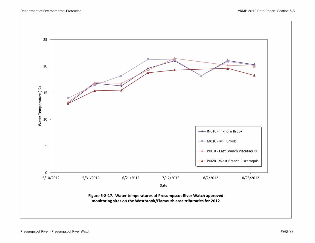
Figure 5-8-17. Water temperatures of Presumpscot River Watch approved monitoring sites on the Westbrook/Flamouth area tributaries for 2012
Page 27

Department of Environmental Protection VRMP 2012 Data Report, Section 5-8
Presumpscot River - Presumpscot River Watch
0
500
1000
1500
2000
2500
5/10/2012 5/31/2012 6/21/2012 7/12/2012 8/2/2012 8/23/2012
E. c
oli
Bac
teri
a (M
PN
/10
0 m
L)
inst
anta
ne
ou
s m
eas
ure
me
nt
: MN
P =
Mo
st P
rob
able
Nu
mb
er
Date
P020 - Presumpscot River, Class C
P030 - Presumpscot River, Class C
P110 - Presumpscot River, Class B
P135 - Presumpscot River, Class B (non-approved)
P150 - Presumpscot River, Class A (non-approved)
P160 - Presumpscot River, Class A (non-approved)
P170 - Presumpscot River, Class A (non-approved)
Stormflow Conditions Noted
E. coli shall not exceed instantaneous level of 236 MPN/100 mL
Values above 2419.6 are not distinguished
Figure 5-8-18. E. Coli backteria at Presumpscot River Watch monitoring sites on the mainstem of the Presumpscot River for 2012
Page 28
Department of Environmental Protection VRMP 2012 Data Report, Section 5-8
Presumpscot River - Presumpscot River Watch
0
500
1000
1500
2000
2500
5/10/2012 5/31/2012 6/21/2012 7/12/2012 8/2/2012 8/23/2012
E. c
oli
Bac
teri
a (M
PN
/10
0 m
L)
inst
anta
ne
ou
s m
eas
ure
me
nt
: MN
P =
Mo
st P
rob
able
Nu
mb
er
Date
BB010 - Baker Brook
DB010 - Ditch Brook
PL010 - Pleasant River
PL040 - Pleasant River
Stormflow Conditions Noted
E. coli shall not exceed instantaneous level of 236 MPN/100 mL
Values above 2419.6 are not distinguished
Figure 5-8-19. E. Coli bacteria at Presumpscot River Watch approved monitoring sites on the Pleasant River and tributaries for 2012
Page 29

Department of Environmental Protection VRMP 2012 Data Report, Section 5-8
Presumpscot River - Presumpscot River Watch
0
500
1000
1500
2000
2500
5/10/2012 5/31/2012 6/21/2012 7/12/2012 8/2/2012 8/23/2012
E. c
oli
Bac
teri
a (M
PN
/10
0 m
L)
inst
anta
ne
ou
s m
eas
ure
me
nt
: MN
P =
Mo
st P
rob
able
Nu
mb
er
Date
BL010 - Black Brook
CW010 - Colley Wright Brook
L010 - Little River (non-approved)
L050 - Little River
N010 - Nason Brook
OB010 - Otter Brook
Stormflow Conditions Noted
E. coli shall not exceed instantaneous level of 236 MPN/100 mL
Values above 2419.6 are not distinguished
Figure 5-8-20. E. Coli bacteria at Presumpscot River Watch monitoring sites on the Windham/Gorham area tributaries for 2012
Page 30
Department of Environmental Protection VRMP 2012 Data Report, Section 5-8
Presumpscot River - Presumpscot River Watch
0
500
1000
1500
2000
2500
5/10/2012 5/31/2012 6/21/2012 7/12/2012 8/2/2012 8/23/2012
E. c
oli
Bac
teri
a (M
PN
/10
0 m
L)
inst
anta
ne
ou
s m
eas
ure
me
nt
: MN
P =
Mo
st P
rob
able
Nu
mb
er
Date
IN010 - Inkhorn Brook
M010 - Mill Brook
PI010 - East Branch Piscataquis
PI020 - West Branch Piscataquis
Stormflow Conditions Noted
E. coli shall not exceed instantaneous level of 236 MPN/100 mL
Values above 2419.6 are not distinguished
Figure 5-8-21. E. Coli bacteria at Presumpscot River Watch approved monitoring sites on the Westbrook/Flamouth area tributaries for 2012
Page 31

Department of Environmental Protection VRMP 2012 Data Report, Section 5-8
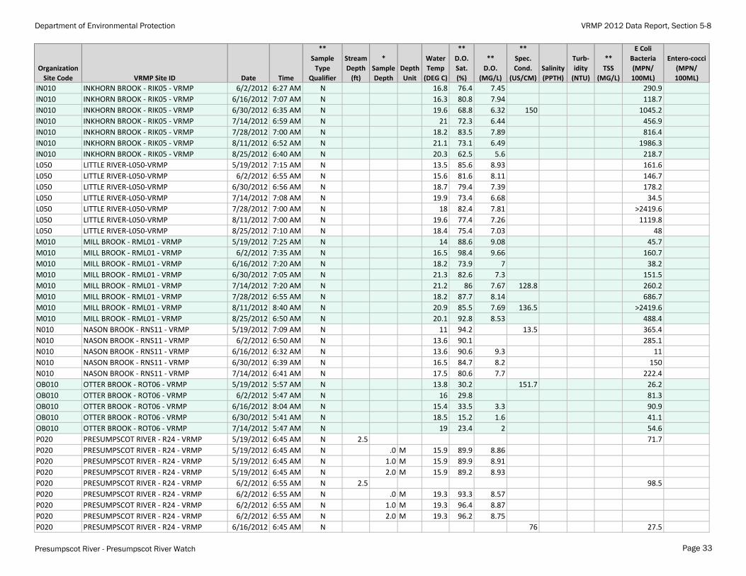
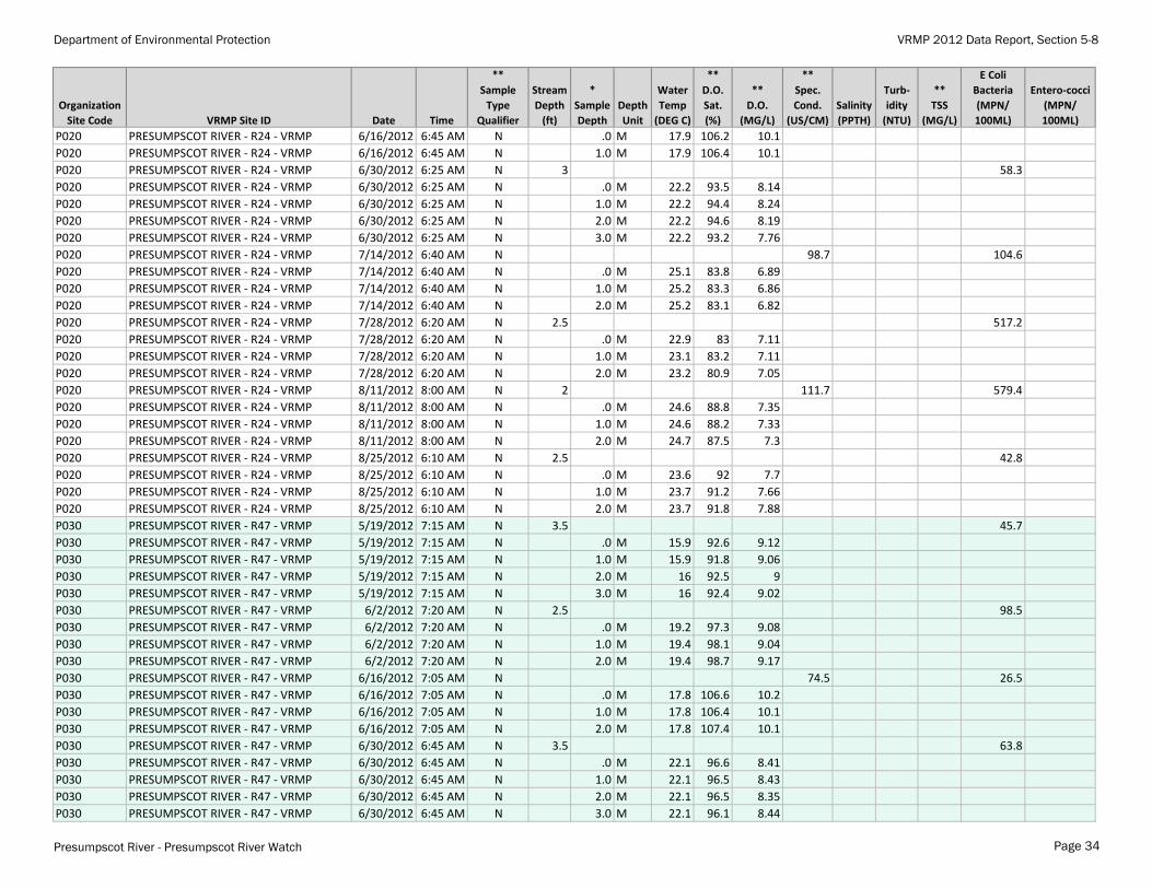
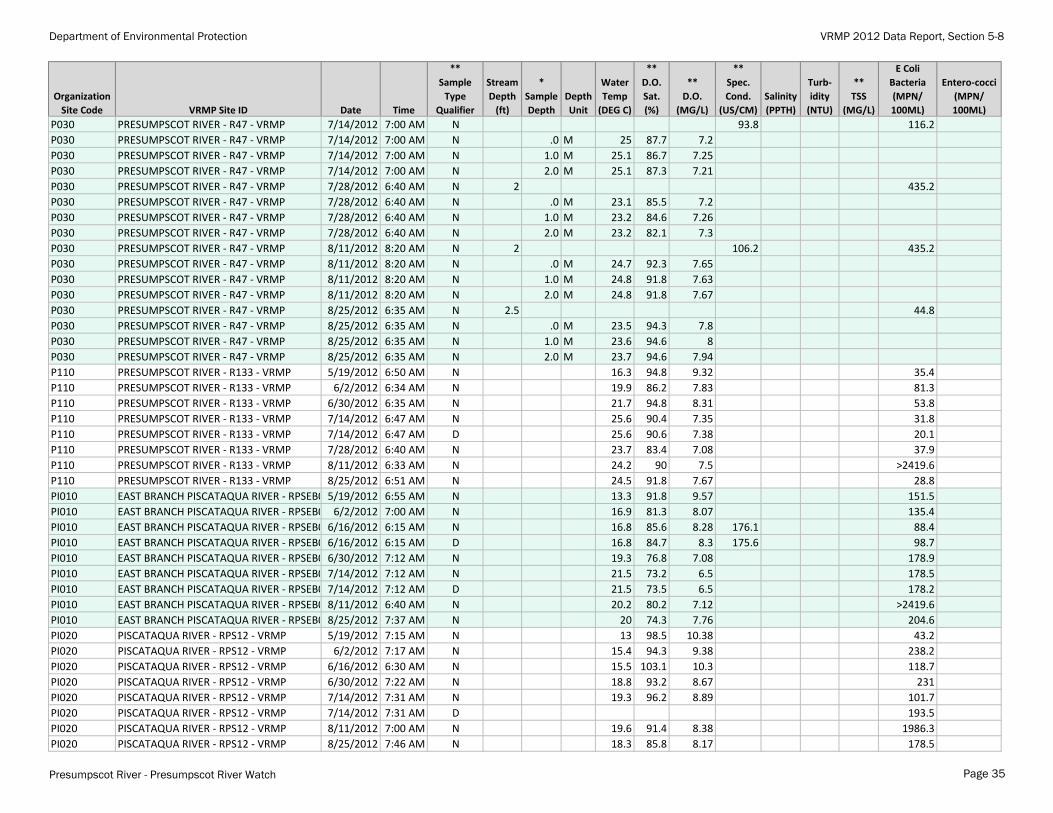
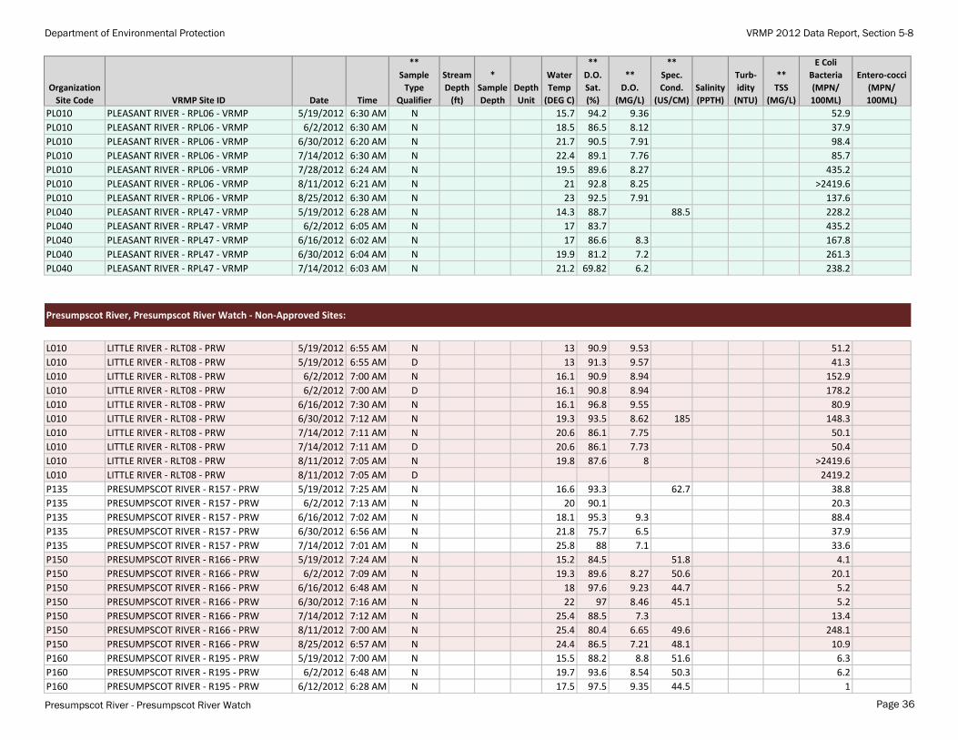
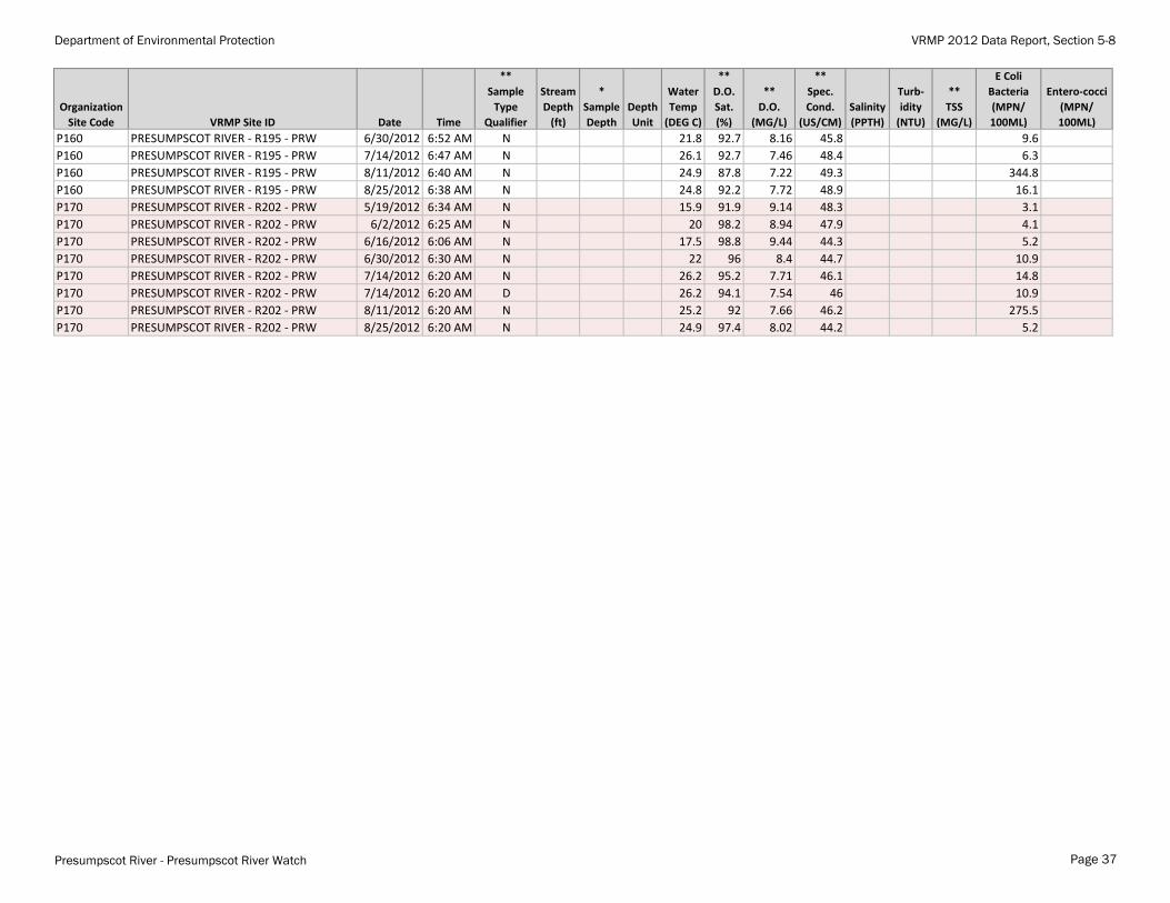
Appendix A-1. 2012 water quality data for "Approved" and "Non-Approved" sites. Non-Approved sites do not yet meet official VRMP sample location criteria and/or require further inspection and review.* Sampling depths are only reported for Tier 1 VRMP sites. ** "N" = normal environmental sample ; "D" = field duplicate; "D.O." = dissolved oxygen; "Spec. Cond" = specific conductance; "Turb" = turbidity; "TSS" = total suspended solids"Refer to Appendix A-2 for observational data and quality assurance/quality control (QA/QC) notes.
Organization
Site Code VRMP Site ID Date Time
**
Sample
Type
Qualifier
Stream
Depth
(ft)
*
Sample
Depth
Depth
Unit
Water
Temp
(DEG C)
**
D.O.
Sat.
(%)
**
D.O.
(MG/L)
**
Spec.
Cond.
(US/CM)
Salinity
(PPTH)
Turb-
idity
(NTU)
**
TSS
(MG/L)
E Coli
Bacteria
(MPN/
100ML)
Entero-cocci
(MPN/
100ML)
Presumpscot River, Presumpscot River Watch - Approved Sites:
BB010 BAKER BROOK - RPLBK17 - VRMP 5/19/2012 6:53 AM N 15.2 77.69 7.8 23.9 21.3
BB010 BAKER BROOK - RPLBK17 - VRMP 6/16/2012 7:00 AM N 17.4 70.95 6.8 26.8 105.9
BB010 BAKER BROOK - RPLBK17 - VRMP 6/30/2012 6:58 AM N 19.8 54.77 5 31.4 66.9
BB010 BAKER BROOK - RPLBK17 - VRMP 7/14/2012 7:01 AM N 19.8 61.35 5.6 34.8 51.2
BB010 BAKER BROOK - RPLBK17 - VRMP 7/28/2012 6:51 AM N 19 66.84 6.2 40.1 290.9
BB010 BAKER BROOK - RPLBK17 - VRMP 8/11/2012 7:00 AM N 20.4 80.3 35.2 1046.2
BB010 BAKER BROOK - RPLBK17 - VRMP 8/25/2012 7:00 AM N 18.9 82.6 7.88 35.5 83.6
BL010 BLACK BROOK- RBK05 -VRMP 5/19/2012 7:25 AM N 11.6 69.9 7.6 168.2 8.6
BL010 BLACK BROOK- RBK05 -VRMP 6/16/2012 7:30 AM N 16 85.1 8.4 149 75.4
BL010 BLACK BROOK- RBK05 -VRMP 6/30/2012 7:25 AM N 18.2 77.43 7.3 162.8 64.4
BL010 BLACK BROOK- RBK05 -VRMP 7/14/2012 7:34 AM N 19 70.07 6.5 187.9 228.2
BL010 BLACK BROOK- RBK05 -VRMP 7/14/2012 7:34 AM D 18.9 6.8 190.1
BL010 BLACK BROOK- RBK05 -VRMP 7/28/2012 7:19 AM N 17.6 73.33 7 176.3 224.7
BL010 BLACK BROOK- RBK05 -VRMP 8/11/2012 7:23 AM N 20.2 93.8 116.4 >2419.6
BL010 BLACK BROOK- RBK05 -VRMP 8/25/2012 7:05 AM N 17.6 90 8.5 62.7
BL010 BLACK BROOK- RBK05 -VRMP 8/25/2012 7:21 AM N 17.2 90.6 8.64 217 52.9
CW010 COLLEY WRIGHT BROOK - RCW10 - VRMP 5/19/2012 6:40 AM N 12.6 88.8 9.44 30.9
CW010 COLLEY WRIGHT BROOK - RCW10 - VRMP 6/2/2012 6:44 AM N 15.7 84.2 8.38 365.4
CW010 COLLEY WRIGHT BROOK - RCW10 - VRMP 6/16/2012 7:26 AM N 15.2 95.5 9.6 88.4
CW010 COLLEY WRIGHT BROOK - RCW10 - VRMP 6/30/2012 6:52 AM N 18.4 88.7 8.27 173 151.5
CW010 COLLEY WRIGHT BROOK - RCW10 - VRMP 6/30/2012 6:52 AM D 18.4 88.7 8.3 175 139.6
CW010 COLLEY WRIGHT BROOK - RCW10 - VRMP 7/14/2012 6:45 AM N 22.8 50.8 4.36 151.5
CW010 COLLEY WRIGHT BROOK - RCW10 - VRMP 7/28/2012 7:14 AM N 17.9 90.1 8.46 1732.8
CW010 COLLEY WRIGHT BROOK - RCW10 - VRMP 8/11/2012 7:00 AM N 20.4 90.8 8.2 >2419.6
CW010 COLLEY WRIGHT BROOK - RCW10 - VRMP 8/25/2012 6:55 AM N 19.7 75.7 6.9 488.4
DB010 DITCH BROOK - RPL00 - VRMP 5/19/2012 6:38 AM N 16.7 97.6 79.6 48
DB010 DITCH BROOK - RPL00 - VRMP 6/2/2012 6:21 AM N 18.9 96.4 56.3
DB010 DITCH BROOK - RPL00 - VRMP 6/16/2012 6:17 AM N 19.7 97.5 8.9 26.9
DB010 DITCH BROOK - RPL00 - VRMP 6/30/2012 6:16 AM N 23 93.5 8 33.6
DB010 DITCH BROOK - RPL00 - VRMP 7/14/2012 6:20 AM N 21.8 93.1 8.1 125.9
DB010 DITCH BROOK - RPL00 - VRMP 7/14/2012 6:20 AM D 77.1
IN010 INKHORN BROOK - RIK05 - VRMP 5/19/2012 6:25 AM N 13 78.6 8.22 65
Presumpscot River - Presumpscot River Watch Page 32
Department of Environmental Protection VRMP 2012 Data Report, Section 5-8
Organization
Site Code VRMP Site ID Date Time
**
Sample
Type
Qualifier
Stream
Depth
(ft)
*
Sample
Depth
Depth
Unit
Water
Temp
(DEG C)
**
D.O.
Sat.
(%)
**
D.O.
(MG/L)
**
Spec.
Cond.
(US/CM)
Salinity
(PPTH)
Turb-
idity
(NTU)
**
TSS
(MG/L)
E Coli
Bacteria
(MPN/
100ML)
Entero-cocci
(MPN/
100ML)
IN010 INKHORN BROOK - RIK05 - VRMP 6/2/2012 6:27 AM N 16.8 76.4 7.45 290.9
IN010 INKHORN BROOK - RIK05 - VRMP 6/16/2012 7:07 AM N 16.3 80.8 7.94 118.7
IN010 INKHORN BROOK - RIK05 - VRMP 6/30/2012 6:35 AM N 19.6 68.8 6.32 150 1045.2
IN010 INKHORN BROOK - RIK05 - VRMP 7/14/2012 6:59 AM N 21 72.3 6.44 456.9
IN010 INKHORN BROOK - RIK05 - VRMP 7/28/2012 7:00 AM N 18.2 83.5 7.89 816.4
IN010 INKHORN BROOK - RIK05 - VRMP 8/11/2012 6:52 AM N 21.1 73.1 6.49 1986.3
IN010 INKHORN BROOK - RIK05 - VRMP 8/25/2012 6:40 AM N 20.3 62.5 5.6 218.7
L050 LITTLE RIVER-L050-VRMP 5/19/2012 7:15 AM N 13.5 85.6 8.93 161.6
L050 LITTLE RIVER-L050-VRMP 6/2/2012 6:55 AM N 15.6 81.6 8.11 146.7
L050 LITTLE RIVER-L050-VRMP 6/30/2012 6:56 AM N 18.7 79.4 7.39 178.2
L050 LITTLE RIVER-L050-VRMP 7/14/2012 7:08 AM N 19.9 73.4 6.68 34.5
L050 LITTLE RIVER-L050-VRMP 7/28/2012 7:00 AM N 18 82.4 7.81 >2419.6
L050 LITTLE RIVER-L050-VRMP 8/11/2012 7:00 AM N 19.6 77.4 7.26 1119.8
L050 LITTLE RIVER-L050-VRMP 8/25/2012 7:10 AM N 18.4 75.4 7.03 48
M010 MILL BROOK - RML01 - VRMP 5/19/2012 7:25 AM N 14 88.6 9.08 45.7
M010 MILL BROOK - RML01 - VRMP 6/2/2012 7:35 AM N 16.5 98.4 9.66 160.7
M010 MILL BROOK - RML01 - VRMP 6/16/2012 7:20 AM N 18.2 73.9 7 38.2
M010 MILL BROOK - RML01 - VRMP 6/30/2012 7:05 AM N 21.3 82.6 7.3 151.5
M010 MILL BROOK - RML01 - VRMP 7/14/2012 7:20 AM N 21.2 86 7.67 128.8 260.2
M010 MILL BROOK - RML01 - VRMP 7/28/2012 6:55 AM N 18.2 87.7 8.14 686.7
M010 MILL BROOK - RML01 - VRMP 8/11/2012 8:40 AM N 20.9 85.5 7.69 136.5 >2419.6
M010 MILL BROOK - RML01 - VRMP 8/25/2012 6:50 AM N 20.1 92.8 8.53 488.4
N010 NASON BROOK - RNS11 - VRMP 5/19/2012 7:09 AM N 11 94.2 13.5 365.4
N010 NASON BROOK - RNS11 - VRMP 6/2/2012 6:50 AM N 13.6 90.1 285.1
N010 NASON BROOK - RNS11 - VRMP 6/16/2012 6:32 AM N 13.6 90.6 9.3 11
N010 NASON BROOK - RNS11 - VRMP 6/30/2012 6:39 AM N 16.5 84.7 8.2 150
N010 NASON BROOK - RNS11 - VRMP 7/14/2012 6:41 AM N 17.5 80.6 7.7 222.4
OB010 OTTER BROOK - ROT06 - VRMP 5/19/2012 5:57 AM N 13.8 30.2 151.7 26.2
OB010 OTTER BROOK - ROT06 - VRMP 6/2/2012 5:47 AM N 16 29.8 81.3
OB010 OTTER BROOK - ROT06 - VRMP 6/16/2012 8:04 AM N 15.4 33.5 3.3 90.9
OB010 OTTER BROOK - ROT06 - VRMP 6/30/2012 5:41 AM N 18.5 15.2 1.6 41.1
OB010 OTTER BROOK - ROT06 - VRMP 7/14/2012 5:47 AM N 19 23.4 2 54.6
P020 PRESUMPSCOT RIVER - R24 - VRMP 5/19/2012 6:45 AM N 2.5 71.7
P020 PRESUMPSCOT RIVER - R24 - VRMP 5/19/2012 6:45 AM N .0 M 15.9 89.9 8.86
P020 PRESUMPSCOT RIVER - R24 - VRMP 5/19/2012 6:45 AM N 1.0 M 15.9 89.9 8.91
P020 PRESUMPSCOT RIVER - R24 - VRMP 5/19/2012 6:45 AM N 2.0 M 15.9 89.2 8.93
P020 PRESUMPSCOT RIVER - R24 - VRMP 6/2/2012 6:55 AM N 2.5 98.5
P020 PRESUMPSCOT RIVER - R24 - VRMP 6/2/2012 6:55 AM N .0 M 19.3 93.3 8.57
P020 PRESUMPSCOT RIVER - R24 - VRMP 6/2/2012 6:55 AM N 1.0 M 19.3 96.4 8.87
P020 PRESUMPSCOT RIVER - R24 - VRMP 6/2/2012 6:55 AM N 2.0 M 19.3 96.2 8.75
P020 PRESUMPSCOT RIVER - R24 - VRMP 6/16/2012 6:45 AM N 76 27.5
Presumpscot River - Presumpscot River Watch Page 33
Department of Environmental Protection VRMP 2012 Data Report, Section 5-8
Organization
Site Code VRMP Site ID Date Time
**
Sample
Type
Qualifier
Stream
Depth
(ft)
*
Sample
Depth
Depth
Unit
Water
Temp
(DEG C)
**
D.O.
Sat.
(%)
**
D.O.
(MG/L)
**
Spec.
Cond.
(US/CM)
Salinity
(PPTH)
Turb-
idity
(NTU)
**
TSS
(MG/L)
E Coli
Bacteria
(MPN/
100ML)
Entero-cocci
(MPN/
100ML)
P020 PRESUMPSCOT RIVER - R24 - VRMP 6/16/2012 6:45 AM N .0 M 17.9 106.2 10.1
P020 PRESUMPSCOT RIVER - R24 - VRMP 6/16/2012 6:45 AM N 1.0 M 17.9 106.4 10.1
P020 PRESUMPSCOT RIVER - R24 - VRMP 6/30/2012 6:25 AM N 3 58.3
P020 PRESUMPSCOT RIVER - R24 - VRMP 6/30/2012 6:25 AM N .0 M 22.2 93.5 8.14
P020 PRESUMPSCOT RIVER - R24 - VRMP 6/30/2012 6:25 AM N 1.0 M 22.2 94.4 8.24
P020 PRESUMPSCOT RIVER - R24 - VRMP 6/30/2012 6:25 AM N 2.0 M 22.2 94.6 8.19
P020 PRESUMPSCOT RIVER - R24 - VRMP 6/30/2012 6:25 AM N 3.0 M 22.2 93.2 7.76
P020 PRESUMPSCOT RIVER - R24 - VRMP 7/14/2012 6:40 AM N 98.7 104.6
P020 PRESUMPSCOT RIVER - R24 - VRMP 7/14/2012 6:40 AM N .0 M 25.1 83.8 6.89
P020 PRESUMPSCOT RIVER - R24 - VRMP 7/14/2012 6:40 AM N 1.0 M 25.2 83.3 6.86
P020 PRESUMPSCOT RIVER - R24 - VRMP 7/14/2012 6:40 AM N 2.0 M 25.2 83.1 6.82
P020 PRESUMPSCOT RIVER - R24 - VRMP 7/28/2012 6:20 AM N 2.5 517.2
P020 PRESUMPSCOT RIVER - R24 - VRMP 7/28/2012 6:20 AM N .0 M 22.9 83 7.11
P020 PRESUMPSCOT RIVER - R24 - VRMP 7/28/2012 6:20 AM N 1.0 M 23.1 83.2 7.11
P020 PRESUMPSCOT RIVER - R24 - VRMP 7/28/2012 6:20 AM N 2.0 M 23.2 80.9 7.05
P020 PRESUMPSCOT RIVER - R24 - VRMP 8/11/2012 8:00 AM N 2 111.7 579.4
P020 PRESUMPSCOT RIVER - R24 - VRMP 8/11/2012 8:00 AM N .0 M 24.6 88.8 7.35
P020 PRESUMPSCOT RIVER - R24 - VRMP 8/11/2012 8:00 AM N 1.0 M 24.6 88.2 7.33
P020 PRESUMPSCOT RIVER - R24 - VRMP 8/11/2012 8:00 AM N 2.0 M 24.7 87.5 7.3
P020 PRESUMPSCOT RIVER - R24 - VRMP 8/25/2012 6:10 AM N 2.5 42.8
P020 PRESUMPSCOT RIVER - R24 - VRMP 8/25/2012 6:10 AM N .0 M 23.6 92 7.7
P020 PRESUMPSCOT RIVER - R24 - VRMP 8/25/2012 6:10 AM N 1.0 M 23.7 91.2 7.66
P020 PRESUMPSCOT RIVER - R24 - VRMP 8/25/2012 6:10 AM N 2.0 M 23.7 91.8 7.88
P030 PRESUMPSCOT RIVER - R47 - VRMP 5/19/2012 7:15 AM N 3.5 45.7
P030 PRESUMPSCOT RIVER - R47 - VRMP 5/19/2012 7:15 AM N .0 M 15.9 92.6 9.12
P030 PRESUMPSCOT RIVER - R47 - VRMP 5/19/2012 7:15 AM N 1.0 M 15.9 91.8 9.06
P030 PRESUMPSCOT RIVER - R47 - VRMP 5/19/2012 7:15 AM N 2.0 M 16 92.5 9
P030 PRESUMPSCOT RIVER - R47 - VRMP 5/19/2012 7:15 AM N 3.0 M 16 92.4 9.02
P030 PRESUMPSCOT RIVER - R47 - VRMP 6/2/2012 7:20 AM N 2.5 98.5
P030 PRESUMPSCOT RIVER - R47 - VRMP 6/2/2012 7:20 AM N .0 M 19.2 97.3 9.08
P030 PRESUMPSCOT RIVER - R47 - VRMP 6/2/2012 7:20 AM N 1.0 M 19.4 98.1 9.04
P030 PRESUMPSCOT RIVER - R47 - VRMP 6/2/2012 7:20 AM N 2.0 M 19.4 98.7 9.17
P030 PRESUMPSCOT RIVER - R47 - VRMP 6/16/2012 7:05 AM N 74.5 26.5
P030 PRESUMPSCOT RIVER - R47 - VRMP 6/16/2012 7:05 AM N .0 M 17.8 106.6 10.2
P030 PRESUMPSCOT RIVER - R47 - VRMP 6/16/2012 7:05 AM N 1.0 M 17.8 106.4 10.1
P030 PRESUMPSCOT RIVER - R47 - VRMP 6/16/2012 7:05 AM N 2.0 M 17.8 107.4 10.1
P030 PRESUMPSCOT RIVER - R47 - VRMP 6/30/2012 6:45 AM N 3.5 63.8
P030 PRESUMPSCOT RIVER - R47 - VRMP 6/30/2012 6:45 AM N .0 M 22.1 96.6 8.41
P030 PRESUMPSCOT RIVER - R47 - VRMP 6/30/2012 6:45 AM N 1.0 M 22.1 96.5 8.43
P030 PRESUMPSCOT RIVER - R47 - VRMP 6/30/2012 6:45 AM N 2.0 M 22.1 96.5 8.35
P030 PRESUMPSCOT RIVER - R47 - VRMP 6/30/2012 6:45 AM N 3.0 M 22.1 96.1 8.44
Presumpscot River - Presumpscot River Watch Page 34
Department of Environmental Protection VRMP 2012 Data Report, Section 5-8
Organization
Site Code VRMP Site ID Date Time
**
Sample
Type
Qualifier
Stream
Depth
(ft)
*
Sample
Depth
Depth
Unit
Water
Temp
(DEG C)
**
D.O.
Sat.
(%)
**
D.O.
(MG/L)
**
Spec.
Cond.
(US/CM)
Salinity
(PPTH)
Turb-
idity
(NTU)
**
TSS
(MG/L)
E Coli
Bacteria
(MPN/
100ML)
Entero-cocci
(MPN/
100ML)
P030 PRESUMPSCOT RIVER - R47 - VRMP 7/14/2012 7:00 AM N 93.8 116.2
P030 PRESUMPSCOT RIVER - R47 - VRMP 7/14/2012 7:00 AM N .0 M 25 87.7 7.2
P030 PRESUMPSCOT RIVER - R47 - VRMP 7/14/2012 7:00 AM N 1.0 M 25.1 86.7 7.25
P030 PRESUMPSCOT RIVER - R47 - VRMP 7/14/2012 7:00 AM N 2.0 M 25.1 87.3 7.21
P030 PRESUMPSCOT RIVER - R47 - VRMP 7/28/2012 6:40 AM N 2 435.2
P030 PRESUMPSCOT RIVER - R47 - VRMP 7/28/2012 6:40 AM N .0 M 23.1 85.5 7.2
P030 PRESUMPSCOT RIVER - R47 - VRMP 7/28/2012 6:40 AM N 1.0 M 23.2 84.6 7.26
P030 PRESUMPSCOT RIVER - R47 - VRMP 7/28/2012 6:40 AM N 2.0 M 23.2 82.1 7.3
P030 PRESUMPSCOT RIVER - R47 - VRMP 8/11/2012 8:20 AM N 2 106.2 435.2
P030 PRESUMPSCOT RIVER - R47 - VRMP 8/11/2012 8:20 AM N .0 M 24.7 92.3 7.65
P030 PRESUMPSCOT RIVER - R47 - VRMP 8/11/2012 8:20 AM N 1.0 M 24.8 91.8 7.63
P030 PRESUMPSCOT RIVER - R47 - VRMP 8/11/2012 8:20 AM N 2.0 M 24.8 91.8 7.67
P030 PRESUMPSCOT RIVER - R47 - VRMP 8/25/2012 6:35 AM N 2.5 44.8
P030 PRESUMPSCOT RIVER - R47 - VRMP 8/25/2012 6:35 AM N .0 M 23.5 94.3 7.8
P030 PRESUMPSCOT RIVER - R47 - VRMP 8/25/2012 6:35 AM N 1.0 M 23.6 94.6 8
P030 PRESUMPSCOT RIVER - R47 - VRMP 8/25/2012 6:35 AM N 2.0 M 23.7 94.6 7.94
P110 PRESUMPSCOT RIVER - R133 - VRMP 5/19/2012 6:50 AM N 16.3 94.8 9.32 35.4
P110 PRESUMPSCOT RIVER - R133 - VRMP 6/2/2012 6:34 AM N 19.9 86.2 7.83 81.3
P110 PRESUMPSCOT RIVER - R133 - VRMP 6/30/2012 6:35 AM N 21.7 94.8 8.31 53.8
P110 PRESUMPSCOT RIVER - R133 - VRMP 7/14/2012 6:47 AM N 25.6 90.4 7.35 31.8
P110 PRESUMPSCOT RIVER - R133 - VRMP 7/14/2012 6:47 AM D 25.6 90.6 7.38 20.1
P110 PRESUMPSCOT RIVER - R133 - VRMP 7/28/2012 6:40 AM N 23.7 83.4 7.08 37.9
P110 PRESUMPSCOT RIVER - R133 - VRMP 8/11/2012 6:33 AM N 24.2 90 7.5 >2419.6
P110 PRESUMPSCOT RIVER - R133 - VRMP 8/25/2012 6:51 AM N 24.5 91.8 7.67 28.8
PI010 EAST BRANCH PISCATAQUA RIVER - RPSEB05 - VRMP5/19/2012 6:55 AM N 13.3 91.8 9.57 151.5
PI010 EAST BRANCH PISCATAQUA RIVER - RPSEB05 - VRMP6/2/2012 7:00 AM N 16.9 81.3 8.07 135.4
PI010 EAST BRANCH PISCATAQUA RIVER - RPSEB05 - VRMP6/16/2012 6:15 AM N 16.8 85.6 8.28 176.1 88.4
PI010 EAST BRANCH PISCATAQUA RIVER - RPSEB05 - VRMP6/16/2012 6:15 AM D 16.8 84.7 8.3 175.6 98.7
PI010 EAST BRANCH PISCATAQUA RIVER - RPSEB05 - VRMP6/30/2012 7:12 AM N 19.3 76.8 7.08 178.9
PI010 EAST BRANCH PISCATAQUA RIVER - RPSEB05 - VRMP7/14/2012 7:12 AM N 21.5 73.2 6.5 178.5
PI010 EAST BRANCH PISCATAQUA RIVER - RPSEB05 - VRMP7/14/2012 7:12 AM D 21.5 73.5 6.5 178.2
PI010 EAST BRANCH PISCATAQUA RIVER - RPSEB05 - VRMP8/11/2012 6:40 AM N 20.2 80.2 7.12 >2419.6
PI010 EAST BRANCH PISCATAQUA RIVER - RPSEB05 - VRMP8/25/2012 7:37 AM N 20 74.3 7.76 204.6
PI020 PISCATAQUA RIVER - RPS12 - VRMP 5/19/2012 7:15 AM N 13 98.5 10.38 43.2
PI020 PISCATAQUA RIVER - RPS12 - VRMP 6/2/2012 7:17 AM N 15.4 94.3 9.38 238.2
PI020 PISCATAQUA RIVER - RPS12 - VRMP 6/16/2012 6:30 AM N 15.5 103.1 10.3 118.7
PI020 PISCATAQUA RIVER - RPS12 - VRMP 6/30/2012 7:22 AM N 18.8 93.2 8.67 231
PI020 PISCATAQUA RIVER - RPS12 - VRMP 7/14/2012 7:31 AM N 19.3 96.2 8.89 101.7
PI020 PISCATAQUA RIVER - RPS12 - VRMP 7/14/2012 7:31 AM D 193.5
PI020 PISCATAQUA RIVER - RPS12 - VRMP 8/11/2012 7:00 AM N 19.6 91.4 8.38 1986.3
PI020 PISCATAQUA RIVER - RPS12 - VRMP 8/25/2012 7:46 AM N 18.3 85.8 8.17 178.5
Presumpscot River - Presumpscot River Watch Page 35
Department of Environmental Protection VRMP 2012 Data Report, Section 5-8
Organization
Site Code VRMP Site ID Date Time
**
Sample
Type
Qualifier
Stream
Depth
(ft)
*
Sample
Depth
Depth
Unit
Water
Temp
(DEG C)
**
D.O.
Sat.
(%)
**
D.O.
(MG/L)
**
Spec.
Cond.
(US/CM)
Salinity
(PPTH)
Turb-
idity
(NTU)
**
TSS
(MG/L)
E Coli
Bacteria
(MPN/
100ML)
Entero-cocci
(MPN/
100ML)
PL010 PLEASANT RIVER - RPL06 - VRMP 5/19/2012 6:30 AM N 15.7 94.2 9.36 52.9
PL010 PLEASANT RIVER - RPL06 - VRMP 6/2/2012 6:30 AM N 18.5 86.5 8.12 37.9
PL010 PLEASANT RIVER - RPL06 - VRMP 6/30/2012 6:20 AM N 21.7 90.5 7.91 98.4
PL010 PLEASANT RIVER - RPL06 - VRMP 7/14/2012 6:30 AM N 22.4 89.1 7.76 85.7
PL010 PLEASANT RIVER - RPL06 - VRMP 7/28/2012 6:24 AM N 19.5 89.6 8.27 435.2
PL010 PLEASANT RIVER - RPL06 - VRMP 8/11/2012 6:21 AM N 21 92.8 8.25 >2419.6
PL010 PLEASANT RIVER - RPL06 - VRMP 8/25/2012 6:30 AM N 23 92.5 7.91 137.6
PL040 PLEASANT RIVER - RPL47 - VRMP 5/19/2012 6:28 AM N 14.3 88.7 88.5 228.2
PL040 PLEASANT RIVER - RPL47 - VRMP 6/2/2012 6:05 AM N 17 83.7 435.2
PL040 PLEASANT RIVER - RPL47 - VRMP 6/16/2012 6:02 AM N 17 86.6 8.3 167.8
PL040 PLEASANT RIVER - RPL47 - VRMP 6/30/2012 6:04 AM N 19.9 81.2 7.2 261.3
PL040 PLEASANT RIVER - RPL47 - VRMP 7/14/2012 6:03 AM N 21.2 69.82 6.2 238.2
Presumpscot River, Presumpscot River Watch - Non-Approved Sites:
L010 LITTLE RIVER - RLT08 - PRW 5/19/2012 6:55 AM N 13 90.9 9.53 51.2
L010 LITTLE RIVER - RLT08 - PRW 5/19/2012 6:55 AM D 13 91.3 9.57 41.3
L010 LITTLE RIVER - RLT08 - PRW 6/2/2012 7:00 AM N 16.1 90.9 8.94 152.9
L010 LITTLE RIVER - RLT08 - PRW 6/2/2012 7:00 AM D 16.1 90.8 8.94 178.2
L010 LITTLE RIVER - RLT08 - PRW 6/16/2012 7:30 AM N 16.1 96.8 9.55 80.9
L010 LITTLE RIVER - RLT08 - PRW 6/30/2012 7:12 AM N 19.3 93.5 8.62 185 148.3
L010 LITTLE RIVER - RLT08 - PRW 7/14/2012 7:11 AM N 20.6 86.1 7.75 50.1
L010 LITTLE RIVER - RLT08 - PRW 7/14/2012 7:11 AM D 20.6 86.1 7.73 50.4
L010 LITTLE RIVER - RLT08 - PRW 8/11/2012 7:05 AM N 19.8 87.6 8 >2419.6
L010 LITTLE RIVER - RLT08 - PRW 8/11/2012 7:05 AM D 2419.2
P135 PRESUMPSCOT RIVER - R157 - PRW 5/19/2012 7:25 AM N 16.6 93.3 62.7 38.8
P135 PRESUMPSCOT RIVER - R157 - PRW 6/2/2012 7:13 AM N 20 90.1 20.3
P135 PRESUMPSCOT RIVER - R157 - PRW 6/16/2012 7:02 AM N 18.1 95.3 9.3 88.4
P135 PRESUMPSCOT RIVER - R157 - PRW 6/30/2012 6:56 AM N 21.8 75.7 6.5 37.9
P135 PRESUMPSCOT RIVER - R157 - PRW 7/14/2012 7:01 AM N 25.8 88 7.1 33.6
P150 PRESUMPSCOT RIVER - R166 - PRW 5/19/2012 7:24 AM N 15.2 84.5 51.8 4.1
P150 PRESUMPSCOT RIVER - R166 - PRW 6/2/2012 7:09 AM N 19.3 89.6 8.27 50.6 20.1
P150 PRESUMPSCOT RIVER - R166 - PRW 6/16/2012 6:48 AM N 18 97.6 9.23 44.7 5.2
P150 PRESUMPSCOT RIVER - R166 - PRW 6/30/2012 7:16 AM N 22 97 8.46 45.1 5.2
P150 PRESUMPSCOT RIVER - R166 - PRW 7/14/2012 7:12 AM N 25.4 88.5 7.3 13.4
P150 PRESUMPSCOT RIVER - R166 - PRW 8/11/2012 7:00 AM N 25.4 80.4 6.65 49.6 248.1
P150 PRESUMPSCOT RIVER - R166 - PRW 8/25/2012 6:57 AM N 24.4 86.5 7.21 48.1 10.9
P160 PRESUMPSCOT RIVER - R195 - PRW 5/19/2012 7:00 AM N 15.5 88.2 8.8 51.6 6.3
P160 PRESUMPSCOT RIVER - R195 - PRW 6/2/2012 6:48 AM N 19.7 93.6 8.54 50.3 6.2
P160 PRESUMPSCOT RIVER - R195 - PRW 6/12/2012 6:28 AM N 17.5 97.5 9.35 44.5 1
Presumpscot River - Presumpscot River Watch Page 36
Department of Environmental Protection VRMP 2012 Data Report, Section 5-8
Organization
Site Code VRMP Site ID Date Time
**
Sample
Type
Qualifier
Stream
Depth
(ft)
*
Sample
Depth
Depth
Unit
Water
Temp
(DEG C)
**
D.O.
Sat.
(%)
**
D.O.
(MG/L)
**
Spec.
Cond.
(US/CM)
Salinity
(PPTH)
Turb-
idity
(NTU)
**
TSS
(MG/L)
E Coli
Bacteria
(MPN/
100ML)
Entero-cocci
(MPN/
100ML)
P160 PRESUMPSCOT RIVER - R195 - PRW 6/30/2012 6:52 AM N 21.8 92.7 8.16 45.8 9.6
P160 PRESUMPSCOT RIVER - R195 - PRW 7/14/2012 6:47 AM N 26.1 92.7 7.46 48.4 6.3
P160 PRESUMPSCOT RIVER - R195 - PRW 8/11/2012 6:40 AM N 24.9 87.8 7.22 49.3 344.8
P160 PRESUMPSCOT RIVER - R195 - PRW 8/25/2012 6:38 AM N 24.8 92.2 7.72 48.9 16.1
P170 PRESUMPSCOT RIVER - R202 - PRW 5/19/2012 6:34 AM N 15.9 91.9 9.14 48.3 3.1
P170 PRESUMPSCOT RIVER - R202 - PRW 6/2/2012 6:25 AM N 20 98.2 8.94 47.9 4.1
P170 PRESUMPSCOT RIVER - R202 - PRW 6/16/2012 6:06 AM N 17.5 98.8 9.44 44.3 5.2
P170 PRESUMPSCOT RIVER - R202 - PRW 6/30/2012 6:30 AM N 22 96 8.4 44.7 10.9
P170 PRESUMPSCOT RIVER - R202 - PRW 7/14/2012 6:20 AM N 26.2 95.2 7.71 46.1 14.8
P170 PRESUMPSCOT RIVER - R202 - PRW 7/14/2012 6:20 AM D 26.2 94.1 7.54 46 10.9
P170 PRESUMPSCOT RIVER - R202 - PRW 8/11/2012 6:20 AM N 25.2 92 7.66 46.2 275.5
P170 PRESUMPSCOT RIVER - R202 - PRW 8/25/2012 6:20 AM N 24.9 97.4 8.02 44.2 5.2
Presumpscot River - Presumpscot River Watch Page 37

Department of Environmental Protection VRMP 2012 Data Report, Section 5-8
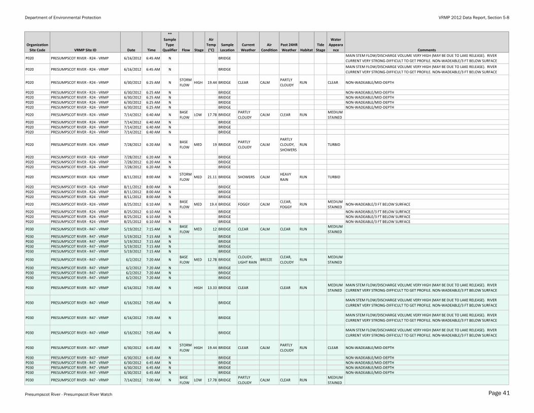
Appendix A-2. 2012 observational data and quality assurance/quality control (QA/QC) notes for "approved" and "non-approved" sites. ** "N" = normal environmental sample; "D" = field duplicate; "L" = lab duplicate; "D.O." = dissolved oxygen; "Spec. Cond" = specific conductance; "Turb"= turbidityRefer to Appendix A-1 for water quality data
Organization
Site Code VRMP Site ID Date Time
**
Sample
Type
Qualifier Flow Stage
Air
Temp
(°C)
Sample
Location
Current
Weather
Air
Condition
Past 24HR
Weather Habitat
Tide
Stage
Water
Appeara
nce Comments
Presumpscot River, Presumpscot River Watch - Approved Sites:
BB010 BAKER BROOK - RPLBK17 - VRMP 5/19/2012 6:53 AM NBASE
FLOWHIGH WADING CLEAR CALM CLEAR RUN
MEDIUM
STAINEDWADEABLE/MID-DEPTH
BB010 BAKER BROOK - RPLBK17 - VRMP 6/16/2012 7:00 AM NSTORM
FLOWHIGH WADING CLEAR CLEAR RUN CLEAR WADEABLE/MID-DEPTH BACTERIA LAB DUPLICATE =93.4
BB010 BAKER BROOK - RPLBK17 - VRMP 6/30/2012 6:58 AM NBASE
FLOWMED WADING CLEAR CALM
CLEAR,
LIGHT
RAIN,
PARTLY
CLOUDY
RUN CLEAR WADEABLE/MID-DEPTH
BB010 BAKER BROOK - RPLBK17 - VRMP 7/14/2012 7:01 AM NBASE
FLOWMED WADING
PARTLY
CLOUDYCALM CLEAR RUN
MEDIUM
STAINEDWADEABLE/MID-DEPTH
BB010 BAKER BROOK - RPLBK17 - VRMP 7/28/2012 6:51 AM NBASE
FLOWMED WADING FOGGY
LIGHT
RAIN,
PARTLY
CLOUDY
RUNMEDIUM
STAINEDWADEABLE/MID-DEPTH
BB010 BAKER BROOK - RPLBK17 - VRMP 8/11/2012 7:00 AM NBASE
FLOWMED WADING CLOUDY
CLOUDY,
HEAVY
RAIN,
LIGHT
RAIN
RUNMEDIUM
STAINEDWADEABLE/MID-DEPTH NO VALUE FOR D.O. IN MG/L.
BB010 BAKER BROOK - RPLBK17 - VRMP 8/25/2012 7:00 AM NBASE
FLOWMED WADING FOGGY
FOGGY,
PARTLY
CLOUDY
RUNDARKLY
STAINEDWADEABLE/MID-DEPTH
BL010 BLACK BROOK- RBK05 -VRMP 5/19/2012 7:25 AM NBASE
FLOWMED WADING CLEAR CALM CLEAR RUN
MEDIUM
STAINEDWADEABLE/MID-DEPTH
BL010 BLACK BROOK- RBK05 -VRMP 6/16/2012 7:30 AM NSTORM
FLOWHIGH WADING CLEAR CLEAR RUN CLEAR WADEABLE/MID-DEPTH
BL010 BLACK BROOK- RBK05 -VRMP 6/30/2012 7:25 AM NBASE
FLOWHIGH WADING CLEAR CALM
CLEAR,
LIGHT
RAIN,
PARTLY
CLOUDY
RUN CLEAR WADEABLE/MID-DEPTH
BL010 BLACK BROOK- RBK05 -VRMP 7/14/2012 7:34 AM NBASE
FLOWMED WADING
PARTLY
CLOUDYCALM CLEAR RUN CLEAR WADEABLE/MID-DEPTH
BL010 BLACK BROOK- RBK05 -VRMP 7/14/2012 7:34 AM D WADING WADEABLE/MID-DEPTH
BL010 BLACK BROOK- RBK05 -VRMP 7/28/2012 7:19 AM NBASE
FLOWMED WADING FOGGY
LIGHT
RAIN,
PARTLY
CLOUDY
RUN CLEAR WADEABLE/MID-DEPTH
BL010 BLACK BROOK- RBK05 -VRMP 8/11/2012 7:23 AM NSTORM
FLOWHIGH WADING CLOUDY
CLOUDY,
HEAVY
RAIN,
LIGHT
RAIN
RUN TURBIDCONCENTRATION IS ACTUALLY >2419.6. VALUE FOR USE IN GEOMETRIC MEAN. WADEABLE/MID-
DEPTH NO VALUE FOR D.O. IN MG/L., WADEABLE/MID-DEPTH NO VALUE FOR D.O. IN MG/L.
BL010 BLACK BROOK- RBK05 -VRMP 8/25/2012 7:05 AM NBASE
FLOWLOW 18.33 WADING FOGGY
CLEAR,
FOGGYRUN CLEAR WADEABLE/MID-DEPTH SAMPLED BY MARY BUSHIKA ALSO ON 8/25/12
BL010 BLACK BROOK- RBK05 -VRMP 8/25/2012 7:21 AM NBASE
FLOWMED WADING FOGGY
FOGGY,
PARTLY
CLOUDY
RUN CLEAR WADEABLE/MID-DEPTH SAMPLED BY FRED DILLON ALSO ON 8/25/12
CW010 COLLEY WRIGHT BROOK - RCW10 - VRMP 5/19/2012 6:40 AM NBASE
FLOWMED BANK CLEAR CLEAR RUN TURBID
NON-WADEABLE/MID-DEPTH DID NOT COMPLETE CHAIN OF CUSTODY FOR DATASHEET. SAMPLE
LOCATION FROM BANK AND NOT "CENTER OF FLOW"-SHOULD BE WADING, EXTENSION POLE OR
OTHER METHOD.
CW010 COLLEY WRIGHT BROOK - RCW10 - VRMP 6/2/2012 6:44 AM NBASE
FLOWMED BANK CLOUDY CALM
CLEAR,
PARTLY
CLOUDY
RUN TURBIDNON-WADEABLE/MID-DEPTH SAMPLE LOCATION FROM BANK AND NOT "CENTER OF FLOW"-
SHOULD BE BY WADING, EXTENSION POLE OR OTHER METHOD.
Presumpscot River - Presumpscot River Watch Page 38

Department of Environmental Protection VRMP 2012 Data Report, Section 5-8
Organization
Site Code VRMP Site ID Date Time
**
Sample
Type
Qualifier Flow Stage
Air
Temp
(°C)
Sample
Location
Current
Weather
Air
Condition
Past 24HR
Weather Habitat
Tide
Stage
Water
Appeara
nce Comments
CW010 COLLEY WRIGHT BROOK - RCW10 - VRMP 6/16/2012 7:26 AM NBASE
FLOWMED BANK CLEAR CALM CLEAR RUN TURBID
NON-WADEABLE/MID-DEPTH SAMPLE LOCATION FROM BANK AND NOT "CENTER OF FLOW"-
SHOULD BE BY WADING, EXTENSION POLE OR OTHER METHOD.
CW010 COLLEY WRIGHT BROOK - RCW10 - VRMP 6/30/2012 6:52 AM NBASE
FLOWMED BANK CLEAR CLEAR RUN TURBID
TEMPERATURE FROM COND. PEN 19.5ºC NON-WADEABLE/MID-DEPTH IDEXX BACTERIA ANALYSES-
1 SMALL WELL EMPTY AND 1 LARGE WELL EMPTY FOR DUPLICATE. SAMPLE LOCATION FROM
BANK AND NOT "CENTER OF FLOW"- SHOULD BE BY WADING, EXTENSION POLE OR OTHER
METHOD.
CW010 COLLEY WRIGHT BROOK - RCW10 - VRMP 6/30/2012 6:52 AM D BANK
TEMPERATURE FROM COND. PEN 19.5ºC NON-WADEABLE/MID-DEPTH IDEXX BACTERIA ANALYSES-
1 SMALL WELL EMPTY AND 1 LARGE WELL EMPTY FOR DUPLICATE. SAMPLE LOCATION FROM
BANK AND NOT "CENTER OF FLOW"- SHOULD BE BY WADING, EXTENSION POLE OR OTHER
METHOD.
CW010 COLLEY WRIGHT BROOK - RCW10 - VRMP 7/14/2012 6:45 AM NBASE
FLOWMED 18.89 BANK CLEAR CALM CLEAR RUN TURBID
NON-WADEABLE/MID-DEPTH SAMPLE LOCATION FROM BANK AND NOT "CENTER OF FLOW" -
SHOULD BE BY WADING, EXTENSION POLE OR OTHER METHOD.
CW010 COLLEY WRIGHT BROOK - RCW10 - VRMP 7/28/2012 7:14 AM NBASE
FLOWMED 17.22 BRIDGE
MOSTLY
CLOUDYCALM
PARTLY
CLOUDY,
SHOWERS
RUN TURBID NON-WADEABLE/MID-DEPTH
CW010 COLLEY WRIGHT BROOK - RCW10 - VRMP 8/11/2012 7:00 AM NSTORM
FLOWHIGH 21.11 BANK
HEAVY
RAIN, LIGHT
RAIN
CLOUDY,
FOGGY,
HEAVY
RAIN,
SHOWERS
RUN TURBID
CONCENTRATION IS ACTUALLY >2419.6. VALUE FOR USE IN GEOMETRIC MEAN. NON-
WADEABLE/MID-DEPTH SAMPLE FROM BANK AND NOT "CENTER OF FLOW" -SHOULD BE BY
WADING, EXTENSION POLE OR OTHER METHOD., NON-WADEABLE/MID-DEPTH SAMPLE FROM
BANK AND NOT "CENTER OF FLOW" -SHOULD BE BY WADING, EXTENSION POLE OR OTHER
METHOD.
CW010 COLLEY WRIGHT BROOK - RCW10 - VRMP 8/25/2012 6:55 AM NBASE
FLOWLOW 18.33 WADING FOGGY
CLEAR,
FOGGYRUN TURBID WADEABLE/MID-DEPTH
DB010 DITCH BROOK - RPL00 - VRMP 5/19/2012 6:38 AM NSTORM
FLOWHIGH 7 WADING CLEAR CALM CLEAR RIFFLE MILKY WADEABLE/MID-DEPTH NO VALUE FOR D.O. IN MG/L
DB010 DITCH BROOK - RPL00 - VRMP 6/2/2012 6:21 AM NBASE
FLOWMED 12.22 BANK CLOUDY CALM CLEAR RIFFLE CLEAR WADEABLE/MID-DEPTH NO VALUE FOR D.O. IN MG/L.
DB010 DITCH BROOK - RPL00 - VRMP 6/16/2012 6:17 AM NBASE
FLOWHIGH 11.11 WADING CLEAR
CLEAR,
CLOUDY,
PARTLY
CLOUDY
RIFFLE MILKY WADEABLE/MID-DEPTH
DB010 DITCH BROOK - RPL00 - VRMP 6/30/2012 6:16 AM NBASE
FLOWHIGH 20 WADING CLEAR
CLEAR,
CLOUDY,
SHOWERS
RIFFLE MILKY WADEABLE/MID-DEPTH
DB010 DITCH BROOK - RPL00 - VRMP 7/14/2012 6:20 AM NBASE
FLOWLOW WADING
CLOUDY,
FOGGYCALM
PARTLY
CLOUDYRIFFLE CLEAR WADEABLE/MID-DEPTH
DB010 DITCH BROOK - RPL00 - VRMP 7/14/2012 6:20 AM D WADING WADEABLE/MID-DEPTH
IN010 INKHORN BROOK - RIK05 - VRMP 5/19/2012 6:25 AM NBASE
FLOWMED BRIDGE CLEAR CLEAR RUN TURBID NON-WADEABLE/MID-DEPTH DID NOT COMPLETE CHAIN OF CUSTODY FOR DATASHEET
IN010 INKHORN BROOK - RIK05 - VRMP 6/2/2012 6:27 AM NBASE
FLOWMED BRIDGE CLOUDY CALM
CLEAR,
PARTLY
CLOUDY
RUN TURBID NON-WADEABLE/MID-DEPTH
IN010 INKHORN BROOK - RIK05 - VRMP 6/16/2012 7:07 AM NBASE
FLOWMED CULVERT CLEAR CALM CLEAR RUN TURBID NON-WADEABLE/MID-DEPTH
IN010 INKHORN BROOK - RIK05 - VRMP 6/30/2012 6:35 AM NBASE
FLOWMED BRIDGE CLEAR CLEAR RUN TURBID NON-WADEABLE/MID-DEPTH
IN010 INKHORN BROOK - RIK05 - VRMP 7/14/2012 6:59 AM NBASE
FLOWMED 18.89 BANK CLEAR CALM CLEAR RUN TURBID
NON-WADEABLE/MID-DEPTH SAMPLE LOCATION FROM BANK AND NOT "CENTER OF FLOW" -
SHOULD BE BY WADING, EXTENSION POLE OR OTHER METHOD.
IN010 INKHORN BROOK - RIK05 - VRMP 7/28/2012 7:00 AM NBASE
FLOWMED 17.22 BRIDGE
PARTLY
CLOUDYCALM
PARTLY
CLOUDY,
SHOWERS
RUN TURBID NON-WADEABLE/MID-DEPTH
IN010 INKHORN BROOK - RIK05 - VRMP 8/11/2012 6:52 AM NSTORM
FLOWHIGH 21.11 BANK
HEAVY
RAIN, LIGHT
RAIN
CLOUDY,
FOGGY,
HEAVY
RAIN,
SHOWERS
RUN TURBID
NON-WADEABLE/MID-DEPTH IDEXX BACTERIA ANALYSES- 1 LARGE WELL MOSTLY EMPTY. SAMPLE
FROM BANK AND NOT "CENTER OF FLOW" -SHOULD BE BY WADING, EXTENSION POLE OR OTHER
METHOD.
IN010 INKHORN BROOK - RIK05 - VRMP 8/25/2012 6:40 AM NBASE
FLOWLOW 18.33 WADING FOGGY
CLEAR,
FOGGYRUN TURBID WADEABLE/MID-DEPTH
L050 LITTLE RIVER-L050-VRMP 5/19/2012 7:15 AM NBASE
FLOWMED 9.444 WADING CLEAR CALM CLEAR RUN
MEDIUM
STAINEDWADEABLE/MID-DEPTH
L050 LITTLE RIVER-L050-VRMP 6/2/2012 6:55 AM NBASE
FLOWMED WADING CLOUDY CALM
CLEAR,
CLOUDYRIFFLE
MEDIUM
STAINED
WADEABLE/MID-DEPTH DID NOT RECORD "TIME OF CALIBRATION". IDEXX BACTERIA ANALYSES- 1
LARGE WELL EMPTY.
L050 LITTLE RIVER-L050-VRMP 6/30/2012 6:56 AM NBASE
FLOWMED 18.89 WADING CLEAR CALM CLEAR RIFFLE
MEDIUM
STAINEDWADEABLE/MID-DEPTH
L050 LITTLE RIVER-L050-VRMP 7/14/2012 7:08 AM NBASE
FLOWMED 18.33 WADING CLEAR CALM CLEAR RUN CLEAR WADEABLE/MID-DEPTH
Presumpscot River - Presumpscot River Watch Page 39

Department of Environmental Protection VRMP 2012 Data Report, Section 5-8
Organization
Site Code VRMP Site ID Date Time
**
Sample
Type
Qualifier Flow Stage
Air
Temp
(°C)
Sample
Location
Current
Weather
Air
Condition
Past 24HR
Weather Habitat
Tide
Stage
Water
Appeara
nce Comments
L050 LITTLE RIVER-L050-VRMP 7/28/2012 7:00 AM NBASE
FLOWMED 17.22 WADING
PARTLY
CLOUDYCALM
PARTLY
CLOUDY,
SHOWERS
RIFFLEMEDIUM
STAINED
CONCENTRATION IS ACTUALLY >2419.6. VALUE FOR USE IN GEOMETRIC MEAN. WADEABLE/MID-
DEPTH, WADEABLE/MID-DEPTH
L050 LITTLE RIVER-L050-VRMP 8/11/2012 7:00 AM NSTORM
FLOWHIGH 20 WADING CALM
HEAVY
RAIN,
SHOWERS
RUN TURBID WADEABLE/MID-DEPTH DID NOT RECORD "TIME OF CALIBRATION".
L050 LITTLE RIVER-L050-VRMP 8/25/2012 7:10 AM NBASE
FLOWMED 18.89 WADING FOGGY CALM
CLEAR,
FOGGY,
PARTLY
CLOUDY
RUNMEDIUM
STAINEDNON-WADEABLE/MID-DEPTH
M010 MILL BROOK - RML01 - VRMP 5/19/2012 7:25 AM NBASE
FLOWMED 12 CULVERT CLEAR CALM CLEAR RUN CLEAR WADEABLE/MID-DEPTH
M010 MILL BROOK - RML01 - VRMP 6/2/2012 7:35 AM NBASE
FLOWMED 12.78 WADING
CLOUDY,
LIGHT RAINBREEZE
CLEAR,
CLOUDYRUN TURBID WADEABLE/MID-DEPTH
M010 MILL BROOK - RML01 - VRMP 6/16/2012 7:20 AM N HIGH 13.33 CULVERT CLEAR CALM CLEAR RUNMEDIUM
STAINEDNO VERTICAL DEPTH RECORDED.
M010 MILL BROOK - RML01 - VRMP 6/30/2012 7:05 AM NSTORM
FLOWHIGH 19.44 BANK CLEAR CALM
PARTLY
CLOUDYRUN TURBID
PRESUMPSCOT APPEARS TO BE BACKED UP INTO MILL BROOK. NON-WADEABLE/MID-DEPTH
SAMPLE LOCATION FROM BANK AND NOT "CENTER OF FLOW" - SHOULD BE BY WADING,
EXTENSION POLE OR OTHER METHOD.
M010 MILL BROOK - RML01 - VRMP 7/14/2012 7:20 AM NBASE
FLOWLOW 17.78 WADING
PARTLY
CLOUDYCALM CLEAR RIFFLE
MEDIUM
STAINEDWADEABLE/MID-DEPTH
M010 MILL BROOK - RML01 - VRMP 7/28/2012 6:55 AM NBASE
FLOWMED 19 BANK
PARTLY
CLOUDYCALM
PARTLY
CLOUDY,
SHOWERS
RUNMEDIUM
STAINED
WADEABLE/MID-DEPTH SAMPLE LOCATION FROM BANK AND NOT "CENTER OF FLOW" - SHOULD
BE WADING, EXTENSION POLE OR OTHER METHOD.
M010 MILL BROOK - RML01 - VRMP 8/11/2012 8:40 AM NSTORM
FLOWMED 21.11 WADING SHOWERS CALM
HEAVY
RAINRUN TURBID
CONCENTRATION IS ACTUALLY >2419.6. VALUE FOR USE IN GEOMETRIC MEAN. WADEABLE/MID-
DEPTH BACTERIA LAB DUPLICATE =1413.6, WADEABLE/MID-DEPTH BACTERIA LAB DUPLICATE
=1413.6
M010 MILL BROOK - RML01 - VRMP 8/25/2012 6:50 AM NBASE
FLOWMED 19.4 WADING FOGGY CALM
CLEAR,
FOGGYRUN CLEAR NON-WADEABLE/MID-DEPTH BACTERIA LAB DUPLICATE = 290.9
N010 NASON BROOK - RNS11 - VRMP 5/19/2012 7:09 AM NSTORM
FLOWMED 6.667 CULVERT CLEAR CLEAR RUN
MEDIUM
STAINED
SWAPPED CONDUCTIVITY PENS-GOT BAD READINGS WADEABLE/MID-DEPTH NO VALUE FOR D.O.
IN MG/L
N010 NASON BROOK - RNS11 - VRMP 6/2/2012 6:50 AM NBASE
FLOWLOW 12.22 WADING CLOUDY BREEZE CLEAR RUN
MEDIUM
STAINEDNON-WADEABLE/MID-DEPTH NO VALUE FOR D.O. IN MG/L.
N010 NASON BROOK - RNS11 - VRMP 6/16/2012 6:32 AM NBASE
FLOWMED 11.11 CULVERT CLEAR
CLEAR,
CLOUDYRUN
MEDIUM
STAINEDWADEABLE/MID-DEPTH
N010 NASON BROOK - RNS11 - VRMP 6/30/2012 6:39 AM NBASE
FLOWLOW 20 WADING CLEAR CALM
CLEAR,
CLOUDY,
SHOWERS
RUNMEDIUM
STAINEDWADEABLE/MID-DEPTH
N010 NASON BROOK - RNS11 - VRMP 7/14/2012 6:41 AM NBASE
FLOWLOW CULVERT
CLOUDY,
FOGGYCALM
PARTLY
CLOUDYRUN
MEDIUM
STAINEDWADEABLE/MID-DEPTH
OB010 OTTER BROOK - ROT06 - VRMP 5/19/2012 5:57 AM NBASE
FLOWMED 6.667 CULVERT CLEAR CALM CLEAR RUN CLEAR WADEABLE/MID-DEPTH NO VALUE FOR D.O. IN MG/L; BACTERIA LAB DUPLICATE=27.2
OB010 OTTER BROOK - ROT06 - VRMP 6/2/2012 5:47 AM NBASE
FLOWMED 12.22 CULVERT CLOUDY CALM CLEAR RUN
MEDIUM
STAINEDWADEABLE/MID-DEPTH NO VALUE FOR D.O. IN MG/L.
OB010 OTTER BROOK - ROT06 - VRMP 6/16/2012 8:04 AM NBASE
FLOWMED 11.11 CULVERT CLEAR
CLEAR,
CLOUDY,
PARTLY
CLOUDY
RUN CLEAR WADEABLE/MID-DEPTH
OB010 OTTER BROOK - ROT06 - VRMP 6/30/2012 5:41 AM NBASE
FLOWMED 20 CULVERT CLEAR CALM
CLEAR,
CLOUDY,
SHOWERS
RUN CLEAR WADEABLE/MID-DEPTH
OB010 OTTER BROOK - ROT06 - VRMP 7/14/2012 5:47 AM NBASE
FLOWLOW CULVERT
CLOUDY,
FOGGYCALM
PARTLY
CLOUDYRUN CLEAR WADEABLE/MID-DEPTH
P020 PRESUMPSCOT RIVER - R24 - VRMP 5/19/2012 6:45 AM NBASE
FLOWMED 12 BRIDGE CLEAR CALM CLEAR RUN
MEDIUM
STAINED
P020 PRESUMPSCOT RIVER - R24 - VRMP 5/19/2012 6:45 AM N BRIDGEP020 PRESUMPSCOT RIVER - R24 - VRMP 5/19/2012 6:45 AM N BRIDGEP020 PRESUMPSCOT RIVER - R24 - VRMP 5/19/2012 6:45 AM N BRIDGE
P020 PRESUMPSCOT RIVER - R24 - VRMP 6/2/2012 6:55 AM NBASE
FLOWMED 12.78 BRIDGE
CLOUDY,
LIGHT RAINBREEZE
CLEAR,
CLOUDYRUN
MEDIUM
STAINED
P020 PRESUMPSCOT RIVER - R24 - VRMP 6/2/2012 6:55 AM N BRIDGEP020 PRESUMPSCOT RIVER - R24 - VRMP 6/2/2012 6:55 AM N BRIDGEP020 PRESUMPSCOT RIVER - R24 - VRMP 6/2/2012 6:55 AM N BRIDGE
P020 PRESUMPSCOT RIVER - R24 - VRMP 6/16/2012 6:45 AM N HIGH 13.33 BRIDGE CLEAR CLEAR RUNMEDIUM
STAINED
MAIN STEM FLOW/DISCHARGE VOLUME VERY HIGH (MAY BE DUE TO LAKE RELEASE). RIVER
CURRENT VERY STRONG-DIFFICULT TO GET PROFILE. NON-WADEABLE/3 FT BELOW SURFACE
Presumpscot River - Presumpscot River Watch Page 40
Department of Environmental Protection VRMP 2012 Data Report, Section 5-8
Organization
Site Code VRMP Site ID Date Time
**
Sample
Type
Qualifier Flow Stage
Air
Temp
(°C)
Sample
Location
Current
Weather
Air
Condition
Past 24HR
Weather Habitat
Tide
Stage
Water
Appeara
nce Comments
P020 PRESUMPSCOT RIVER - R24 - VRMP 6/16/2012 6:45 AM N BRIDGEMAIN STEM FLOW/DISCHARGE VOLUME VERY HIGH (MAY BE DUE TO LAKE RELEASE). RIVER
CURRENT VERY STRONG-DIFFICULT TO GET PROFILE. NON-WADEABLE/3 FT BELOW SURFACE
P020 PRESUMPSCOT RIVER - R24 - VRMP 6/16/2012 6:45 AM N BRIDGEMAIN STEM FLOW/DISCHARGE VOLUME VERY HIGH (MAY BE DUE TO LAKE RELEASE). RIVER
CURRENT VERY STRONG-DIFFICULT TO GET PROFILE. NON-WADEABLE/3 FT BELOW SURFACE
P020 PRESUMPSCOT RIVER - R24 - VRMP 6/30/2012 6:25 AM NSTORM
FLOWHIGH 19.44 BRIDGE CLEAR CALM
PARTLY
CLOUDYRUN CLEAR NON-WADEABLE/MID-DEPTH
P020 PRESUMPSCOT RIVER - R24 - VRMP 6/30/2012 6:25 AM N BRIDGE NON-WADEABLE/MID-DEPTHP020 PRESUMPSCOT RIVER - R24 - VRMP 6/30/2012 6:25 AM N BRIDGE NON-WADEABLE/MID-DEPTHP020 PRESUMPSCOT RIVER - R24 - VRMP 6/30/2012 6:25 AM N BRIDGE NON-WADEABLE/MID-DEPTHP020 PRESUMPSCOT RIVER - R24 - VRMP 6/30/2012 6:25 AM N BRIDGE NON-WADEABLE/MID-DEPTH
P020 PRESUMPSCOT RIVER - R24 - VRMP 7/14/2012 6:40 AM NBASE
FLOWLOW 17.78 BRIDGE
PARTLY
CLOUDYCALM CLEAR RUN
MEDIUM
STAINEDP020 PRESUMPSCOT RIVER - R24 - VRMP 7/14/2012 6:40 AM N BRIDGEP020 PRESUMPSCOT RIVER - R24 - VRMP 7/14/2012 6:40 AM N BRIDGEP020 PRESUMPSCOT RIVER - R24 - VRMP 7/14/2012 6:40 AM N BRIDGE
P020 PRESUMPSCOT RIVER - R24 - VRMP 7/28/2012 6:20 AM NBASE
FLOWMED 19 BRIDGE
PARTLY
CLOUDYCALM
PARTLY
CLOUDY,
SHOWERS
RUN TURBID
P020 PRESUMPSCOT RIVER - R24 - VRMP 7/28/2012 6:20 AM N BRIDGEP020 PRESUMPSCOT RIVER - R24 - VRMP 7/28/2012 6:20 AM N BRIDGEP020 PRESUMPSCOT RIVER - R24 - VRMP 7/28/2012 6:20 AM N BRIDGE
P020 PRESUMPSCOT RIVER - R24 - VRMP 8/11/2012 8:00 AM NSTORM
FLOWMED 21.11 BRIDGE SHOWERS CALM
HEAVY
RAINRUN TURBID
P020 PRESUMPSCOT RIVER - R24 - VRMP 8/11/2012 8:00 AM N BRIDGEP020 PRESUMPSCOT RIVER - R24 - VRMP 8/11/2012 8:00 AM N BRIDGEP020 PRESUMPSCOT RIVER - R24 - VRMP 8/11/2012 8:00 AM N BRIDGE
P020 PRESUMPSCOT RIVER - R24 - VRMP 8/25/2012 6:10 AM NBASE
FLOWMED 19.4 BRIDGE FOGGY CALM
CLEAR,
FOGGYRUN
MEDIUM
STAINEDNON-WADEABLE/3 FT BELOW SURFACE
P020 PRESUMPSCOT RIVER - R24 - VRMP 8/25/2012 6:10 AM N BRIDGE NON-WADEABLE/3 FT BELOW SURFACEP020 PRESUMPSCOT RIVER - R24 - VRMP 8/25/2012 6:10 AM N BRIDGE NON-WADEABLE/3 FT BELOW SURFACEP020 PRESUMPSCOT RIVER - R24 - VRMP 8/25/2012 6:10 AM N BRIDGE NON-WADEABLE/3 FT BELOW SURFACE
P030 PRESUMPSCOT RIVER - R47 - VRMP 5/19/2012 7:15 AM NBASE
FLOWMED 12 BRIDGE CLEAR CALM CLEAR RUN
MEDIUM
STAINEDP030 PRESUMPSCOT RIVER - R47 - VRMP 5/19/2012 7:15 AM N BRIDGEP030 PRESUMPSCOT RIVER - R47 - VRMP 5/19/2012 7:15 AM N BRIDGEP030 PRESUMPSCOT RIVER - R47 - VRMP 5/19/2012 7:15 AM N BRIDGEP030 PRESUMPSCOT RIVER - R47 - VRMP 5/19/2012 7:15 AM N BRIDGE
P030 PRESUMPSCOT RIVER - R47 - VRMP 6/2/2012 7:20 AM NBASE
FLOWMED 12.78 BRIDGE
CLOUDY,
LIGHT RAINBREEZE
CLEAR,
CLOUDYRUN
MEDIUM
STAINED
P030 PRESUMPSCOT RIVER - R47 - VRMP 6/2/2012 7:20 AM N BRIDGEP030 PRESUMPSCOT RIVER - R47 - VRMP 6/2/2012 7:20 AM N BRIDGEP030 PRESUMPSCOT RIVER - R47 - VRMP 6/2/2012 7:20 AM N BRIDGE
P030 PRESUMPSCOT RIVER - R47 - VRMP 6/16/2012 7:05 AM N HIGH 13.33 BRIDGE CLEAR CLEAR RUNMEDIUM
STAINED
MAIN STEM FLOW/DISCHARGE VOLUME VERY HIGH (MAY BE DUE TO LAKE RELEASE). RIVER
CURRENT VERY STRONG-DIFFICULT TO GET PROFILE. NON-WADEABLE/3 FT BELOW SURFACE
P030 PRESUMPSCOT RIVER - R47 - VRMP 6/16/2012 7:05 AM N BRIDGEMAIN STEM FLOW/DISCHARGE VOLUME VERY HIGH (MAY BE DUE TO LAKE RELEASE). RIVER
CURRENT VERY STRONG-DIFFICULT TO GET PROFILE. NON-WADEABLE/3 FT BELOW SURFACE
P030 PRESUMPSCOT RIVER - R47 - VRMP 6/16/2012 7:05 AM N BRIDGEMAIN STEM FLOW/DISCHARGE VOLUME VERY HIGH (MAY BE DUE TO LAKE RELEASE). RIVER
CURRENT VERY STRONG-DIFFICULT TO GET PROFILE. NON-WADEABLE/3 FT BELOW SURFACE
P030 PRESUMPSCOT RIVER - R47 - VRMP 6/16/2012 7:05 AM N BRIDGEMAIN STEM FLOW/DISCHARGE VOLUME VERY HIGH (MAY BE DUE TO LAKE RELEASE). RIVER
CURRENT VERY STRONG-DIFFICULT TO GET PROFILE. NON-WADEABLE/3 FT BELOW SURFACE
P030 PRESUMPSCOT RIVER - R47 - VRMP 6/30/2012 6:45 AM NSTORM
FLOWHIGH 19.44 BRIDGE CLEAR CALM
PARTLY
CLOUDYRUN CLEAR NON-WADEABLE/MID-DEPTH
P030 PRESUMPSCOT RIVER - R47 - VRMP 6/30/2012 6:45 AM N BRIDGE NON-WADEABLE/MID-DEPTHP030 PRESUMPSCOT RIVER - R47 - VRMP 6/30/2012 6:45 AM N BRIDGE NON-WADEABLE/MID-DEPTHP030 PRESUMPSCOT RIVER - R47 - VRMP 6/30/2012 6:45 AM N BRIDGE NON-WADEABLE/MID-DEPTHP030 PRESUMPSCOT RIVER - R47 - VRMP 6/30/2012 6:45 AM N BRIDGE NON-WADEABLE/MID-DEPTH
P030 PRESUMPSCOT RIVER - R47 - VRMP 7/14/2012 7:00 AM NBASE
FLOWLOW 17.78 BRIDGE
PARTLY
CLOUDYCALM CLEAR RUN
MEDIUM
STAINED
Presumpscot River - Presumpscot River Watch Page 41
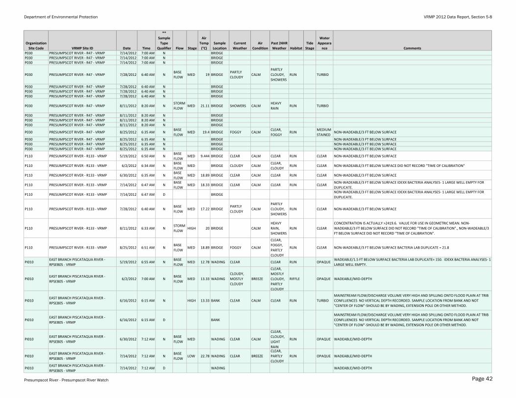
Department of Environmental Protection VRMP 2012 Data Report, Section 5-8
Organization
Site Code VRMP Site ID Date Time
**
Sample
Type
Qualifier Flow Stage
Air
Temp
(°C)
Sample
Location
Current
Weather
Air
Condition
Past 24HR
Weather Habitat
Tide
Stage
Water
Appeara
nce CommentsP030 PRESUMPSCOT RIVER - R47 - VRMP 7/14/2012 7:00 AM N BRIDGEP030 PRESUMPSCOT RIVER - R47 - VRMP 7/14/2012 7:00 AM N BRIDGEP030 PRESUMPSCOT RIVER - R47 - VRMP 7/14/2012 7:00 AM N BRIDGE
P030 PRESUMPSCOT RIVER - R47 - VRMP 7/28/2012 6:40 AM NBASE
FLOWMED 19 BRIDGE
PARTLY
CLOUDYCALM
PARTLY
CLOUDY,
SHOWERS
RUN TURBID
P030 PRESUMPSCOT RIVER - R47 - VRMP 7/28/2012 6:40 AM N BRIDGEP030 PRESUMPSCOT RIVER - R47 - VRMP 7/28/2012 6:40 AM N BRIDGEP030 PRESUMPSCOT RIVER - R47 - VRMP 7/28/2012 6:40 AM N BRIDGE
P030 PRESUMPSCOT RIVER - R47 - VRMP 8/11/2012 8:20 AM NSTORM
FLOWMED 21.11 BRIDGE SHOWERS CALM
HEAVY
RAINRUN TURBID
P030 PRESUMPSCOT RIVER - R47 - VRMP 8/11/2012 8:20 AM N BRIDGEP030 PRESUMPSCOT RIVER - R47 - VRMP 8/11/2012 8:20 AM N BRIDGEP030 PRESUMPSCOT RIVER - R47 - VRMP 8/11/2012 8:20 AM N BRIDGE
P030 PRESUMPSCOT RIVER - R47 - VRMP 8/25/2012 6:35 AM NBASE
FLOWMED 19.4 BRIDGE FOGGY CALM
CLEAR,
FOGGYRUN
MEDIUM
STAINEDNON-WADEABLE/3 FT BELOW SURFACE
P030 PRESUMPSCOT RIVER - R47 - VRMP 8/25/2012 6:35 AM N BRIDGE NON-WADEABLE/3 FT BELOW SURFACEP030 PRESUMPSCOT RIVER - R47 - VRMP 8/25/2012 6:35 AM N BRIDGE NON-WADEABLE/3 FT BELOW SURFACEP030 PRESUMPSCOT RIVER - R47 - VRMP 8/25/2012 6:35 AM N BRIDGE NON-WADEABLE/3 FT BELOW SURFACE
P110 PRESUMPSCOT RIVER - R133 - VRMP 5/19/2012 6:50 AM NBASE
FLOWMED 9.444 BRIDGE CLEAR CALM CLEAR RUN CLEAR NON-WADEABLE/3 FT BELOW SURFACE
P110 PRESUMPSCOT RIVER - R133 - VRMP 6/2/2012 6:34 AM NBASE
FLOWMED BRIDGE CLOUDY CALM
CLEAR,
CLOUDYRUN CLEAR NON-WADEABLE/3 FT BELOW SURFACE DID NOT RECORD "TIME OF CALIBRATION"
P110 PRESUMPSCOT RIVER - R133 - VRMP 6/30/2012 6:35 AM NBASE
FLOWMED 18.89 BRIDGE CLEAR CALM CLEAR RUN CLEAR NON-WADEABLE/3 FT BELOW SURFACE
P110 PRESUMPSCOT RIVER - R133 - VRMP 7/14/2012 6:47 AM NBASE
FLOWMED 18.33 BRIDGE CLEAR CALM CLEAR RUN CLEAR
NON-WADEABLE/3 FT BELOW SURFACE IDEXX BACTERIA ANALYSES- 1 LARGE WELL EMPTY FOR
DUPLICATE.
P110 PRESUMPSCOT RIVER - R133 - VRMP 7/14/2012 6:47 AM D BRIDGENON-WADEABLE/3 FT BELOW SURFACE IDEXX BACTERIA ANALYSES- 1 LARGE WELL EMPTY FOR
DUPLICATE.
P110 PRESUMPSCOT RIVER - R133 - VRMP 7/28/2012 6:40 AM NBASE
FLOWMED 17.22 BRIDGE
PARTLY
CLOUDYCALM
PARTLY
CLOUDY,
SHOWERS
RUN CLEAR NON-WADEABLE/3 FT BELOW SURFACE
P110 PRESUMPSCOT RIVER - R133 - VRMP 8/11/2012 6:33 AM NSTORM
FLOWHIGH 20 BRIDGE CALM
HEAVY
RAIN,
SHOWERS
RUN CLEAR
CONCENTRATION IS ACTUALLY >2419.6. VALUE FOR USE IN GEOMETRIC MEAN. NON-
WADEABLE/3 FT BELOW SURFACE DID NOT RECORD "TIME OF CALIBRATION"., NON-WADEABLE/3
FT BELOW SURFACE DID NOT RECORD "TIME OF CALIBRATION".
P110 PRESUMPSCOT RIVER - R133 - VRMP 8/25/2012 6:51 AM NBASE
FLOWMED 18.89 BRIDGE FOGGY CALM
CLEAR,
FOGGY,
PARTLY
CLOUDY
RUN CLEAR NON-WADEABLE/3 FT BELOW SURFACE BACTERIA LAB DUPLICATE = 21.8
PI010EAST BRANCH PISCATAQUA RIVER -
RPSEB05 - VRMP5/19/2012 6:55 AM N
BASE
FLOWMED 12.78 WADING CLEAR CLEAR RUN OPAQUE
WADEABLE/1.5 FT BELOW SURFACE BACTERIA LAB DUPLICATE= 150. IDEXX BACTERIA ANALYSES- 1
LARGE WELL EMPTY.
PI010EAST BRANCH PISCATAQUA RIVER -
RPSEB05 - VRMP6/2/2012 7:00 AM N
BASE
FLOWMED 13.33 WADING
CLOUDY,
MOSTLY
CLOUDY
BREEZE
CLEAR,
MOSTLY
CLOUDY,
PARTLY
CLOUDY
RIFFLE OPAQUE WADEABLE/MID-DEPTH
PI010EAST BRANCH PISCATAQUA RIVER -
RPSEB05 - VRMP6/16/2012 6:15 AM N HIGH 13.33 BANK CLEAR CALM CLEAR RUN TURBID
MAINSTREAM FLOW/DISCHARGE VOLUME VERY HIGH AND SPILLING ONTO FLOOD PLAIN AT TRIB
CONFLUENCES NO VERTICAL DEPTH RECORDED. SAMPLE LOCATION FROM BANK AND NOT
"CENTER OF FLOW"-SHOULD BE BY WADING, EXTENSION POLE OR OTHER METHOD.
PI010EAST BRANCH PISCATAQUA RIVER -
RPSEB05 - VRMP6/16/2012 6:15 AM D BANK
MAINSTREAM FLOW/DISCHARGE VOLUME VERY HIGH AND SPILLING ONTO FLOOD PLAIN AT TRIB
CONFLUENCES NO VERTICAL DEPTH RECORDED. SAMPLE LOCATION FROM BANK AND NOT
"CENTER OF FLOW"-SHOULD BE BY WADING, EXTENSION POLE OR OTHER METHOD.
PI010EAST BRANCH PISCATAQUA RIVER -
RPSEB05 - VRMP6/30/2012 7:12 AM N
BASE
FLOWMED WADING CLEAR CALM
CLEAR,
CLOUDY,
LIGHT
RAIN
RUN OPAQUE WADEABLE/MID-DEPTH
PI010EAST BRANCH PISCATAQUA RIVER -
RPSEB05 - VRMP7/14/2012 7:12 AM N
BASE
FLOWLOW 22.78 WADING CLEAR BREEZE
CLEAR,
PARTLY
CLOUDY
RUN OPAQUE WADEABLE/MID-DEPTH
PI010EAST BRANCH PISCATAQUA RIVER -
RPSEB05 - VRMP7/14/2012 7:12 AM D WADING WADEABLE/MID-DEPTH
Presumpscot River - Presumpscot River Watch Page 42
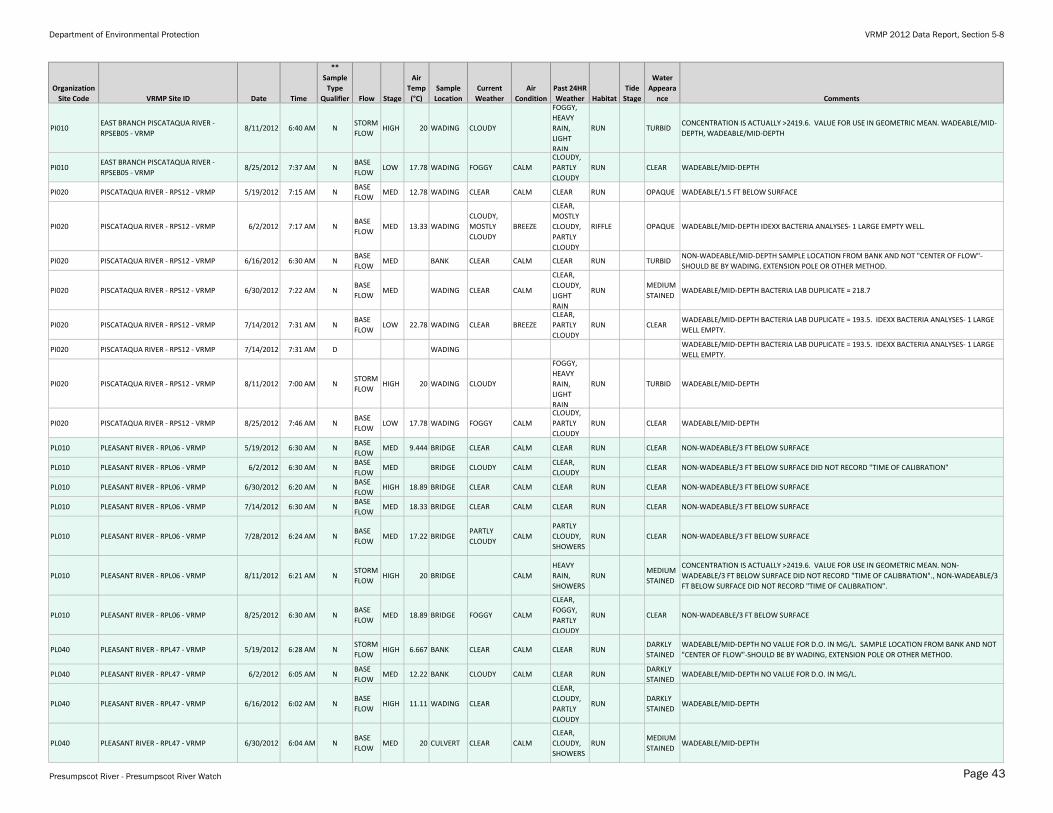
Department of Environmental Protection VRMP 2012 Data Report, Section 5-8
Organization
Site Code VRMP Site ID Date Time
**
Sample
Type
Qualifier Flow Stage
Air
Temp
(°C)
Sample
Location
Current
Weather
Air
Condition
Past 24HR
Weather Habitat
Tide
Stage
Water
Appeara
nce Comments
PI010EAST BRANCH PISCATAQUA RIVER -
RPSEB05 - VRMP8/11/2012 6:40 AM N
STORM
FLOWHIGH 20 WADING CLOUDY
FOGGY,
HEAVY
RAIN,
LIGHT
RAIN
RUN TURBIDCONCENTRATION IS ACTUALLY >2419.6. VALUE FOR USE IN GEOMETRIC MEAN. WADEABLE/MID-
DEPTH, WADEABLE/MID-DEPTH
PI010EAST BRANCH PISCATAQUA RIVER -
RPSEB05 - VRMP8/25/2012 7:37 AM N
BASE
FLOWLOW 17.78 WADING FOGGY CALM
CLOUDY,
PARTLY
CLOUDY
RUN CLEAR WADEABLE/MID-DEPTH
PI020 PISCATAQUA RIVER - RPS12 - VRMP 5/19/2012 7:15 AM NBASE
FLOWMED 12.78 WADING CLEAR CALM CLEAR RUN OPAQUE WADEABLE/1.5 FT BELOW SURFACE
PI020 PISCATAQUA RIVER - RPS12 - VRMP 6/2/2012 7:17 AM NBASE
FLOWMED 13.33 WADING
CLOUDY,
MOSTLY
CLOUDY
BREEZE
CLEAR,
MOSTLY
CLOUDY,
PARTLY
CLOUDY
RIFFLE OPAQUE WADEABLE/MID-DEPTH IDEXX BACTERIA ANALYSES- 1 LARGE EMPTY WELL.
PI020 PISCATAQUA RIVER - RPS12 - VRMP 6/16/2012 6:30 AM NBASE
FLOWMED BANK CLEAR CALM CLEAR RUN TURBID
NON-WADEABLE/MID-DEPTH SAMPLE LOCATION FROM BANK AND NOT "CENTER OF FLOW"-
SHOULD BE BY WADING, EXTENSION POLE OR OTHER METHOD.
PI020 PISCATAQUA RIVER - RPS12 - VRMP 6/30/2012 7:22 AM NBASE
FLOWMED WADING CLEAR CALM
CLEAR,
CLOUDY,
LIGHT
RAIN
RUNMEDIUM
STAINEDWADEABLE/MID-DEPTH BACTERIA LAB DUPLICATE = 218.7
PI020 PISCATAQUA RIVER - RPS12 - VRMP 7/14/2012 7:31 AM NBASE
FLOWLOW 22.78 WADING CLEAR BREEZE
CLEAR,
PARTLY
CLOUDY
RUN CLEARWADEABLE/MID-DEPTH BACTERIA LAB DUPLICATE = 193.5. IDEXX BACTERIA ANALYSES- 1 LARGE
WELL EMPTY.
PI020 PISCATAQUA RIVER - RPS12 - VRMP 7/14/2012 7:31 AM D WADINGWADEABLE/MID-DEPTH BACTERIA LAB DUPLICATE = 193.5. IDEXX BACTERIA ANALYSES- 1 LARGE
WELL EMPTY.
PI020 PISCATAQUA RIVER - RPS12 - VRMP 8/11/2012 7:00 AM NSTORM
FLOWHIGH 20 WADING CLOUDY
FOGGY,
HEAVY
RAIN,
LIGHT
RAIN
RUN TURBID WADEABLE/MID-DEPTH
PI020 PISCATAQUA RIVER - RPS12 - VRMP 8/25/2012 7:46 AM NBASE
FLOWLOW 17.78 WADING FOGGY CALM
CLOUDY,
PARTLY
CLOUDY
RUN CLEAR WADEABLE/MID-DEPTH
PL010 PLEASANT RIVER - RPL06 - VRMP 5/19/2012 6:30 AM NBASE
FLOWMED 9.444 BRIDGE CLEAR CALM CLEAR RUN CLEAR NON-WADEABLE/3 FT BELOW SURFACE
PL010 PLEASANT RIVER - RPL06 - VRMP 6/2/2012 6:30 AM NBASE
FLOWMED BRIDGE CLOUDY CALM
CLEAR,
CLOUDYRUN CLEAR NON-WADEABLE/3 FT BELOW SURFACE DID NOT RECORD "TIME OF CALIBRATION"
PL010 PLEASANT RIVER - RPL06 - VRMP 6/30/2012 6:20 AM NBASE
FLOWHIGH 18.89 BRIDGE CLEAR CALM CLEAR RUN CLEAR NON-WADEABLE/3 FT BELOW SURFACE
PL010 PLEASANT RIVER - RPL06 - VRMP 7/14/2012 6:30 AM NBASE
FLOWMED 18.33 BRIDGE CLEAR CALM CLEAR RUN CLEAR NON-WADEABLE/3 FT BELOW SURFACE
PL010 PLEASANT RIVER - RPL06 - VRMP 7/28/2012 6:24 AM NBASE
FLOWMED 17.22 BRIDGE
PARTLY
CLOUDYCALM
PARTLY
CLOUDY,
SHOWERS
RUN CLEAR NON-WADEABLE/3 FT BELOW SURFACE
PL010 PLEASANT RIVER - RPL06 - VRMP 8/11/2012 6:21 AM NSTORM
FLOWHIGH 20 BRIDGE CALM
HEAVY
RAIN,
SHOWERS
RUNMEDIUM
STAINED
CONCENTRATION IS ACTUALLY >2419.6. VALUE FOR USE IN GEOMETRIC MEAN. NON-
WADEABLE/3 FT BELOW SURFACE DID NOT RECORD "TIME OF CALIBRATION"., NON-WADEABLE/3
FT BELOW SURFACE DID NOT RECORD "TIME OF CALIBRATION".
PL010 PLEASANT RIVER - RPL06 - VRMP 8/25/2012 6:30 AM NBASE
FLOWMED 18.89 BRIDGE FOGGY CALM
CLEAR,
FOGGY,
PARTLY
CLOUDY
RUN CLEAR NON-WADEABLE/3 FT BELOW SURFACE
PL040 PLEASANT RIVER - RPL47 - VRMP 5/19/2012 6:28 AM NSTORM
FLOWHIGH 6.667 BANK CLEAR CALM CLEAR RUN
DARKLY
STAINED
WADEABLE/MID-DEPTH NO VALUE FOR D.O. IN MG/L. SAMPLE LOCATION FROM BANK AND NOT
"CENTER OF FLOW"-SHOULD BE BY WADING, EXTENSION POLE OR OTHER METHOD.
PL040 PLEASANT RIVER - RPL47 - VRMP 6/2/2012 6:05 AM NBASE
FLOWMED 12.22 BANK CLOUDY CALM CLEAR RUN
DARKLY
STAINEDWADEABLE/MID-DEPTH NO VALUE FOR D.O. IN MG/L.
PL040 PLEASANT RIVER - RPL47 - VRMP 6/16/2012 6:02 AM NBASE
FLOWHIGH 11.11 WADING CLEAR
CLEAR,
CLOUDY,
PARTLY
CLOUDY
RUNDARKLY
STAINEDWADEABLE/MID-DEPTH
PL040 PLEASANT RIVER - RPL47 - VRMP 6/30/2012 6:04 AM NBASE
FLOWMED 20 CULVERT CLEAR CALM
CLEAR,
CLOUDY,
SHOWERS
RUNMEDIUM
STAINEDWADEABLE/MID-DEPTH
Presumpscot River - Presumpscot River Watch Page 43
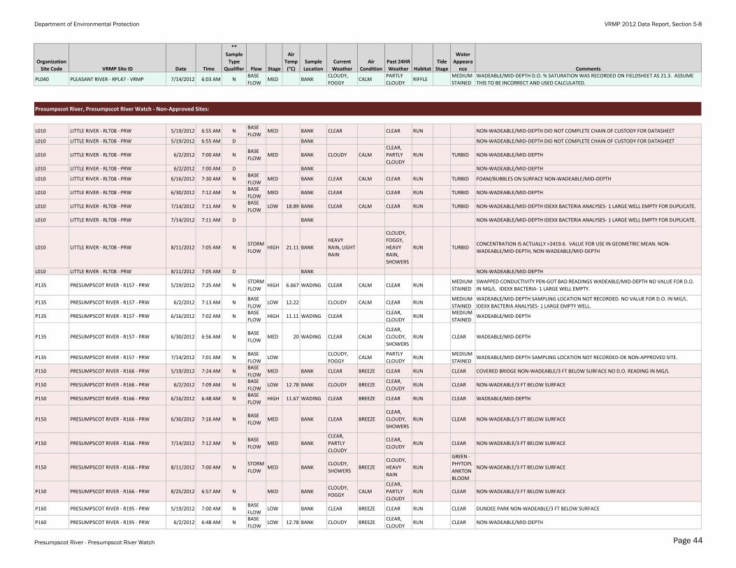
Department of Environmental Protection VRMP 2012 Data Report, Section 5-8
Organization
Site Code VRMP Site ID Date Time
**
Sample
Type
Qualifier Flow Stage
Air
Temp
(°C)
Sample
Location
Current
Weather
Air
Condition
Past 24HR
Weather Habitat
Tide
Stage
Water
Appeara
nce Comments
PL040 PLEASANT RIVER - RPL47 - VRMP 7/14/2012 6:03 AM NBASE
FLOWMED BANK
CLOUDY,
FOGGYCALM
PARTLY
CLOUDYRIFFLE
MEDIUM
STAINED
WADEABLE/MID-DEPTH D.O. % SATURATION WAS RECORDED ON FIELDSHEET AS 21.3. ASSUME
THIS TO BE INCORRECT AND USED CALCULATED.
Presumpscot River, Presumpscot River Watch - Non-Approved Sites:
L010 LITTLE RIVER - RLT08 - PRW 5/19/2012 6:55 AM NBASE
FLOWMED BANK CLEAR CLEAR RUN NON-WADEABLE/MID-DEPTH DID NOT COMPLETE CHAIN OF CUSTODY FOR DATASHEET
L010 LITTLE RIVER - RLT08 - PRW 5/19/2012 6:55 AM D BANK NON-WADEABLE/MID-DEPTH DID NOT COMPLETE CHAIN OF CUSTODY FOR DATASHEET
L010 LITTLE RIVER - RLT08 - PRW 6/2/2012 7:00 AM NBASE
FLOWMED BANK CLOUDY CALM
CLEAR,
PARTLY
CLOUDY
RUN TURBID NON-WADEABLE/MID-DEPTH
L010 LITTLE RIVER - RLT08 - PRW 6/2/2012 7:00 AM D BANK NON-WADEABLE/MID-DEPTH
L010 LITTLE RIVER - RLT08 - PRW 6/16/2012 7:30 AM NBASE
FLOWMED BANK CLEAR CALM CLEAR RUN TURBID FOAM/BUBBLES ON SURFACE NON-WADEABLE/MID-DEPTH
L010 LITTLE RIVER - RLT08 - PRW 6/30/2012 7:12 AM NBASE
FLOWMED BANK CLEAR CLEAR RUN TURBID NON-WADEABLE/MID-DEPTH
L010 LITTLE RIVER - RLT08 - PRW 7/14/2012 7:11 AM NBASE
FLOWLOW 18.89 BANK CLEAR CALM CLEAR RUN TURBID NON-WADEABLE/MID-DEPTH IDEXX BACTERIA ANALYSES- 1 LARGE WELL EMPTY FOR DUPLICATE.
L010 LITTLE RIVER - RLT08 - PRW 7/14/2012 7:11 AM D BANK NON-WADEABLE/MID-DEPTH IDEXX BACTERIA ANALYSES- 1 LARGE WELL EMPTY FOR DUPLICATE.
L010 LITTLE RIVER - RLT08 - PRW 8/11/2012 7:05 AM NSTORM
FLOWHIGH 21.11 BANK
HEAVY
RAIN, LIGHT
RAIN
CLOUDY,
FOGGY,
HEAVY
RAIN,
SHOWERS
RUN TURBIDCONCENTRATION IS ACTUALLY >2419.6. VALUE FOR USE IN GEOMETRIC MEAN. NON-
WADEABLE/MID-DEPTH, NON-WADEABLE/MID-DEPTH
L010 LITTLE RIVER - RLT08 - PRW 8/11/2012 7:05 AM D BANK NON-WADEABLE/MID-DEPTH
P135 PRESUMPSCOT RIVER - R157 - PRW 5/19/2012 7:25 AM NSTORM
FLOWHIGH 6.667 WADING CLEAR CALM CLEAR RUN
MEDIUM
STAINED
SWAPPED CONDUCTIVITY PEN-GOT BAD READINGS WADEABLE/MID-DEPTH NO VALUE FOR D.O.
IN MG/L. IDEXX BACTERIA- 1 LARGE WELL EMPTY.
P135 PRESUMPSCOT RIVER - R157 - PRW 6/2/2012 7:13 AM NBASE
FLOWLOW 12.22 CLOUDY CALM CLEAR RUN
MEDIUM
STAINED
WADEABLE/MID-DEPTH SAMPLING LOCATION NOT RECORDED. NO VALUE FOR D.O. IN MG/L.
IDEXX BACTERIA ANALYSES- 1 LARGE EMPTY WELL.
P135 PRESUMPSCOT RIVER - R157 - PRW 6/16/2012 7:02 AM NBASE
FLOWHIGH 11.11 WADING CLEAR
CLEAR,
CLOUDYRUN
MEDIUM
STAINEDWADEABLE/MID-DEPTH
P135 PRESUMPSCOT RIVER - R157 - PRW 6/30/2012 6:56 AM NBASE
FLOWMED 20 WADING CLEAR CALM
CLEAR,
CLOUDY,
SHOWERS
RUN CLEAR WADEABLE/MID-DEPTH
P135 PRESUMPSCOT RIVER - R157 - PRW 7/14/2012 7:01 AM NBASE
FLOWLOW
CLOUDY,
FOGGYCALM
PARTLY
CLOUDYRUN
MEDIUM
STAINEDWADEABLE/MID-DEPTH SAMPLING LOCATION NOT RECORDED-OK NON-APPROVED SITE.
P150 PRESUMPSCOT RIVER - R166 - PRW 5/19/2012 7:24 AM NBASE
FLOWMED BANK CLEAR BREEZE CLEAR RUN CLEAR COVERED BRIDGE NON-WADEABLE/3 FT BELOW SURFACE NO D.O. READING IN MG/L
P150 PRESUMPSCOT RIVER - R166 - PRW 6/2/2012 7:09 AM NBASE
FLOWLOW 12.78 BANK CLOUDY BREEZE
CLEAR,
CLOUDYRUN CLEAR NON-WADEABLE/3 FT BELOW SURFACE
P150 PRESUMPSCOT RIVER - R166 - PRW 6/16/2012 6:48 AM NBASE
FLOWHIGH 11.67 WADING CLEAR BREEZE CLEAR RUN CLEAR WADEABLE/MID-DEPTH
P150 PRESUMPSCOT RIVER - R166 - PRW 6/30/2012 7:16 AM NBASE
FLOWMED BANK CLEAR BREEZE
CLEAR,
CLOUDY,
SHOWERS
RUN CLEAR NON-WADEABLE/3 FT BELOW SURFACE
P150 PRESUMPSCOT RIVER - R166 - PRW 7/14/2012 7:12 AM NBASE
FLOWMED BANK
CLEAR,
PARTLY
CLOUDY
CLEAR,
CLOUDYRUN CLEAR NON-WADEABLE/3 FT BELOW SURFACE
P150 PRESUMPSCOT RIVER - R166 - PRW 8/11/2012 7:00 AM NSTORM
FLOWMED BANK
CLOUDY,
SHOWERSBREEZE
CLOUDY,
HEAVY
RAIN
RUN
GREEN -
PHYTOPL
ANKTON
BLOOM
NON-WADEABLE/3 FT BELOW SURFACE
P150 PRESUMPSCOT RIVER - R166 - PRW 8/25/2012 6:57 AM N MED BANKCLOUDY,
FOGGYCALM
CLEAR,
PARTLY
CLOUDY
RUN CLEAR NON-WADEABLE/3 FT BELOW SURFACE
P160 PRESUMPSCOT RIVER - R195 - PRW 5/19/2012 7:00 AM NBASE
FLOWLOW BANK CLEAR BREEZE CLEAR RUN CLEAR DUNDEE PARK NON-WADEABLE/3 FT BELOW SURFACE
P160 PRESUMPSCOT RIVER - R195 - PRW 6/2/2012 6:48 AM NBASE
FLOWLOW 12.78 BANK CLOUDY BREEZE
CLEAR,
CLOUDYRUN CLEAR NON-WADEABLE/MID-DEPTH
Presumpscot River - Presumpscot River Watch Page 44
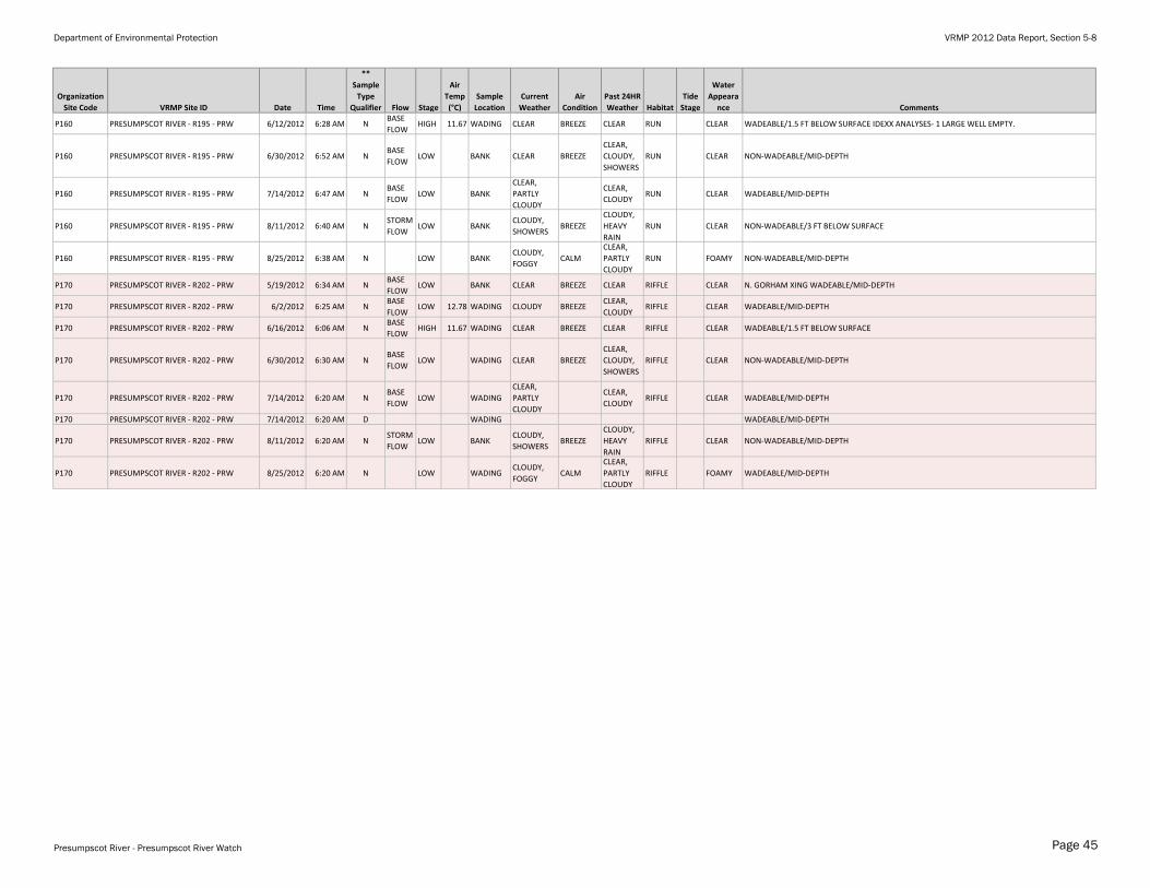
Department of Environmental Protection VRMP 2012 Data Report, Section 5-8
Organization
Site Code VRMP Site ID Date Time
**
Sample
Type
Qualifier Flow Stage
Air
Temp
(°C)
Sample
Location
Current
Weather
Air
Condition
Past 24HR
Weather Habitat
Tide
Stage
Water
Appeara
nce Comments
P160 PRESUMPSCOT RIVER - R195 - PRW 6/12/2012 6:28 AM NBASE
FLOWHIGH 11.67 WADING CLEAR BREEZE CLEAR RUN CLEAR WADEABLE/1.5 FT BELOW SURFACE IDEXX ANALYSES- 1 LARGE WELL EMPTY.
P160 PRESUMPSCOT RIVER - R195 - PRW 6/30/2012 6:52 AM NBASE
FLOWLOW BANK CLEAR BREEZE
CLEAR,
CLOUDY,
SHOWERS
RUN CLEAR NON-WADEABLE/MID-DEPTH
P160 PRESUMPSCOT RIVER - R195 - PRW 7/14/2012 6:47 AM NBASE
FLOWLOW BANK
CLEAR,
PARTLY
CLOUDY
CLEAR,
CLOUDYRUN CLEAR WADEABLE/MID-DEPTH
P160 PRESUMPSCOT RIVER - R195 - PRW 8/11/2012 6:40 AM NSTORM
FLOWLOW BANK
CLOUDY,
SHOWERSBREEZE
CLOUDY,
HEAVY
RAIN
RUN CLEAR NON-WADEABLE/3 FT BELOW SURFACE
P160 PRESUMPSCOT RIVER - R195 - PRW 8/25/2012 6:38 AM N LOW BANKCLOUDY,
FOGGYCALM
CLEAR,
PARTLY
CLOUDY
RUN FOAMY NON-WADEABLE/MID-DEPTH
P170 PRESUMPSCOT RIVER - R202 - PRW 5/19/2012 6:34 AM NBASE
FLOWLOW BANK CLEAR BREEZE CLEAR RIFFLE CLEAR N. GORHAM XING WADEABLE/MID-DEPTH
P170 PRESUMPSCOT RIVER - R202 - PRW 6/2/2012 6:25 AM NBASE
FLOWLOW 12.78 WADING CLOUDY BREEZE
CLEAR,
CLOUDYRIFFLE CLEAR WADEABLE/MID-DEPTH
P170 PRESUMPSCOT RIVER - R202 - PRW 6/16/2012 6:06 AM NBASE
FLOWHIGH 11.67 WADING CLEAR BREEZE CLEAR RIFFLE CLEAR WADEABLE/1.5 FT BELOW SURFACE
P170 PRESUMPSCOT RIVER - R202 - PRW 6/30/2012 6:30 AM NBASE
FLOWLOW WADING CLEAR BREEZE
CLEAR,
CLOUDY,
SHOWERS
RIFFLE CLEAR NON-WADEABLE/MID-DEPTH
P170 PRESUMPSCOT RIVER - R202 - PRW 7/14/2012 6:20 AM NBASE
FLOWLOW WADING
CLEAR,
PARTLY
CLOUDY
CLEAR,
CLOUDYRIFFLE CLEAR WADEABLE/MID-DEPTH
P170 PRESUMPSCOT RIVER - R202 - PRW 7/14/2012 6:20 AM D WADING WADEABLE/MID-DEPTH
P170 PRESUMPSCOT RIVER - R202 - PRW 8/11/2012 6:20 AM NSTORM
FLOWLOW BANK
CLOUDY,
SHOWERSBREEZE
CLOUDY,
HEAVY
RAIN
RIFFLE CLEAR NON-WADEABLE/MID-DEPTH
P170 PRESUMPSCOT RIVER - R202 - PRW 8/25/2012 6:20 AM N LOW WADINGCLOUDY,
FOGGYCALM
CLEAR,
PARTLY
CLOUDY
RIFFLE FOAMY WADEABLE/MID-DEPTH
Presumpscot River - Presumpscot River Watch Page 45