Embed Size (px)
Citation preview
Section 5 –Rehabilitation Strategy
Mt Arthur Coal Open Cut Modification – Environmental Assessment
5-i
TABLE OF CONTENTS 5 REHABILITATION STRATEGY 5-1
5.1 EXISTING MT ARTHUR COAL MINE REHABILITATION INITIATIVES 5-1 5.1.1 Rehabilitation Objectives 5-1 5.1.2 Rehabilitation Strategy 5-1 5.1.3 Biodiversity and
Rehabilitation Management Plan 5-3
5.1.4 Relevant Planning Instruments 5-4
5.1.5 Final Landform 5-4 5.1.6 Decommissioning Activities 5-7 5.1.7 Final Land Use 5-7 5.1.8 General Rehabilitation
Procedures 5-7 5.1.9 Rehabilitation Monitoring 5-7
5.2 REHABILITATION CHANGES RELEVANT TO THE MODIFICATION 5-8
5.3 FUTURE LANDSCAPES DESIGN PROJECT 5-8
LIST OF TABLES
Table 5-1 Goals, Objectives and Completion Criteria of the Mt Arthur Coal Rehabilitation Program – Rehabilitation Focus
Table 5-2 Goals, Objectives and Completion Criteria of the Mt Arthur Coal Rehabilitation Program – Land Use Focus
LIST OF FIGURES
Figure 5-1 Approved Rehabilitation Plan and Offset Strategy
Figure 5-2 Proposed Rehabilitation Plan and Offset Strategy
Mt Arthur Coal Open Cut Modification – Environmental Assessment
5-1
5 REHABILITATION STRATEGY This section summarises the approach to rehabilitation and mine closure for the modified Mt Arthur Coal Mine. It describes how the mine would be progressively rehabilitated and integrated into the landscape, and the measures which would be put in place for the long-term protection and management of the site following the cessation of mining. In accordance with the NSW Mining Act, 1992, rehabilitation would be subject to agreement and approval from the relevant regulatory authorities. The rehabilitation concepts presented below are therefore provisional to allow for the consideration of the results of current and proposed investigations, as well as consultation with regulatory authorities and other stakeholders. The results of rehabilitation investigations and proposed rehabilitation concepts for the Mt Arthur Coal Mine are currently documented in the 2011 AEMR (BHP Billiton, 2011a).
5.1 EXISTING MT ARTHUR COAL MINE REHABILITATION INITIATIVES
5.1.1 Rehabilitation Objectives HVEC’s key rehabilitation objective is to ensure that processes are undertaken generally in accordance with the Strategic Framework for Mine Closure (Australian and New Zealand Minerals and Energy Council and Minerals Council of Australia, 2000), and the Integrated Landscapes for Coal Mine Rehabilitation in the Hunter Valley of NSW (herein referred to as the Synoptic Plan) (Andrews, 1999) including (HVEC, 2009) to: • achieve land capability following the cessation
of mining that is comparable to pre-mining land capability and considers stakeholder’s interests;
• allow for sustainable post-mining land use(s) to occur;
• establish a clear set of performance indicators to be met;
• improve linkages between existing areas of remnant vegetation; and
• increase the average percentage of native woodland to improve habitat value (i.e. at least 30 percent of rehabilitation areas will be returned to native woodland).
5.1.2 Rehabilitation Strategy The Mt Arthur Coal Rehabilitation Strategy has been prepared in order to address Condition 42, Schedule 3 of Project Approval (09_0062). The objectives of the Rehabilitation Strategy are to provide a structure which underpins the mine closure planning and assessment process and a transparent and overarching framework that can be utilised during current and future stakeholder engagement programmes. To assist in defining the lands encompassed in the Rehabilitation Strategy, the site has been divided into domains based on function and final land use. The domains include: • active mining;
• overburden emplacement;
• final void;
• infrastructure areas;
• water management;
• tailing storage facility;
• post-mined lands – pasture;
• post-mined lands – woodland;
• offset areas; and
• non-operational lands. The final land use for the specific domains are described in Section 5.1.5; the Rehabilitation Monitoring Program is outlined in Section 5.1.9; and a summary of goals, objectives and completion criteria related to rehabilitation domains are outlined in Tables 5-1 and 5-2.
Mt Arthur Coal Open Cut Modification – Environmental Assessment
5-2
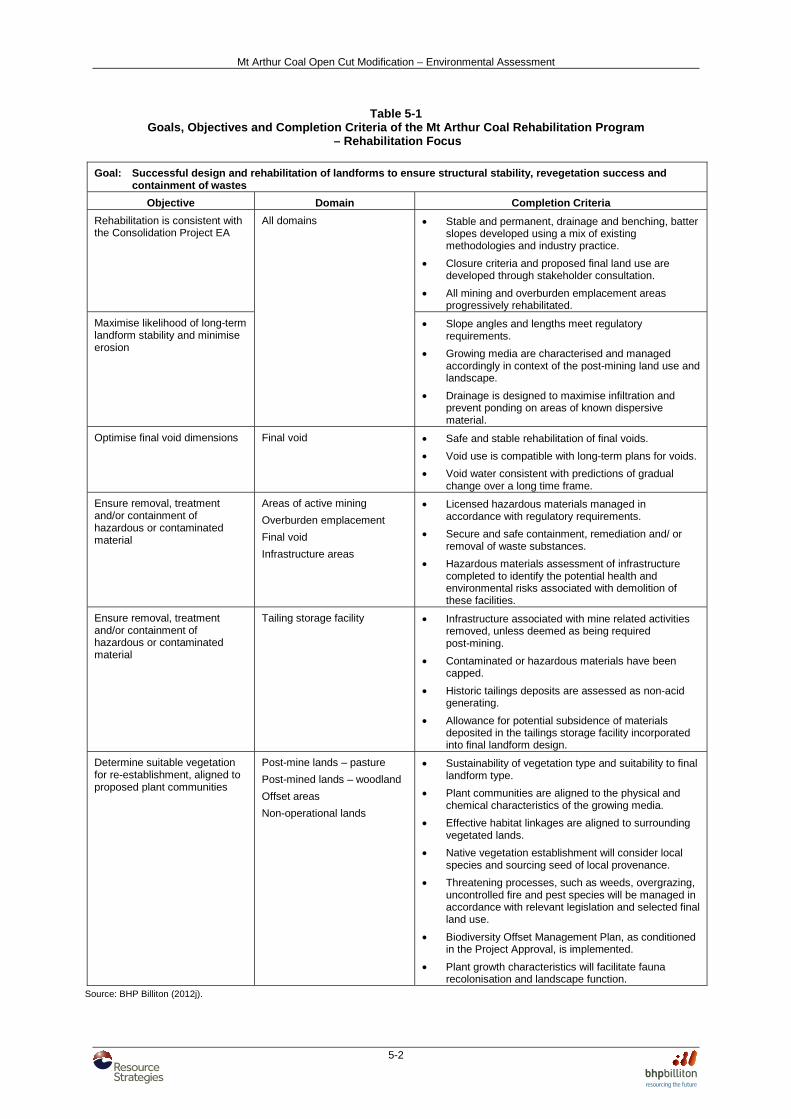
Table 5-1 Goals, Objectives and Completion Criteria of the Mt Arthur Coal Rehabilitation Program
– Rehabilitation Focus
Goal: Successful design and rehabilitation of landforms to ensure structural stability, revegetation success and containment of wastes
Objective Domain Completion Criteria
Rehabilitation is consistent with the Consolidation Project EA
All domains • Stable and permanent, drainage and benching, batter slopes developed using a mix of existing methodologies and industry practice.
• Closure criteria and proposed final land use are developed through stakeholder consultation.
• All mining and overburden emplacement areas progressively rehabilitated.
Maximise likelihood of long-term landform stability and minimise erosion
• Slope angles and lengths meet regulatory requirements.
• Growing media are characterised and managed accordingly in context of the post-mining land use and landscape.
• Drainage is designed to maximise infiltration and prevent ponding on areas of known dispersive material.
Optimise final void dimensions Final void • Safe and stable rehabilitation of final voids.
• Void use is compatible with long-term plans for voids.
• Void water consistent with predictions of gradual change over a long time frame.
Ensure removal, treatment and/or containment of hazardous or contaminated material
Areas of active mining
Overburden emplacement
Final void
Infrastructure areas
• Licensed hazardous materials managed in accordance with regulatory requirements.
• Secure and safe containment, remediation and/ or removal of waste substances.
• Hazardous materials assessment of infrastructure completed to identify the potential health and environmental risks associated with demolition of these facilities.
Ensure removal, treatment and/or containment of hazardous or contaminated material
Tailing storage facility • Infrastructure associated with mine related activities removed, unless deemed as being required post-mining.
• Contaminated or hazardous materials have been capped.
• Historic tailings deposits are assessed as non-acid generating.
• Allowance for potential subsidence of materials deposited in the tailings storage facility incorporated into final landform design.
Determine suitable vegetation for re-establishment, aligned to proposed plant communities
Post-mine lands – pasture
Post-mined lands – woodland
Offset areas
Non-operational lands
• Sustainability of vegetation type and suitability to final landform type.
• Plant communities are aligned to the physical and chemical characteristics of the growing media.
• Effective habitat linkages are aligned to surrounding vegetated lands.
• Native vegetation establishment will consider local species and sourcing seed of local provenance.
• Threatening processes, such as weeds, overgrazing, uncontrolled fire and pest species will be managed in accordance with relevant legislation and selected final land use.
• Biodiversity Offset Management Plan, as conditioned in the Project Approval, is implemented.
• Plant growth characteristics will facilitate fauna recolonisation and landscape function.
Source: BHP Billiton (2012j).
Mt Arthur Coal Open Cut Modification – Environmental Assessment
5-3
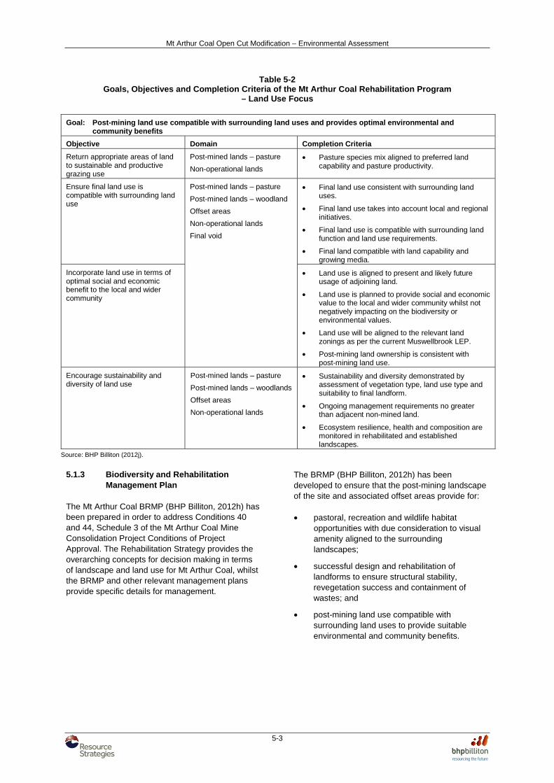
Table 5-2 Goals, Objectives and Completion Criteria of the Mt Arthur Coal Rehabilitation Program
– Land Use Focus Goal: Post-mining land use compatible with surrounding land uses and provides optimal environmental and
community benefits
Objective Domain Completion Criteria
Return appropriate areas of land to sustainable and productive grazing use
Post-mined lands – pasture
Non-operational lands
• Pasture species mix aligned to preferred land capability and pasture productivity.
Ensure final land use is compatible with surrounding land use
Post-mined lands – pasture
Post-mined lands – woodland
Offset areas
Non-operational lands
Final void
• Final land use consistent with surrounding land uses.
• Final land use takes into account local and regional initiatives.
• Final land use is compatible with surrounding land function and land use requirements.
• Final land compatible with land capability and growing media.
Incorporate land use in terms of optimal social and economic benefit to the local and wider community
• Land use is aligned to present and likely future usage of adjoining land.
• Land use is planned to provide social and economic value to the local and wider community whilst not negatively impacting on the biodiversity or environmental values.
• Land use will be aligned to the relevant land zonings as per the current Muswellbrook LEP.
• Post-mining land ownership is consistent with post-mining land use.
Encourage sustainability and diversity of land use
Post-mined lands – pasture
Post-mined lands – woodlands
Offset areas
Non-operational lands
• Sustainability and diversity demonstrated by assessment of vegetation type, land use type and suitability to final landform.
• Ongoing management requirements no greater than adjacent non-mined land.
• Ecosystem resilience, health and composition are monitored in rehabilitated and established landscapes.
Source: BHP Billiton (2012j).
5.1.3 Biodiversity and Rehabilitation
Management Plan The Mt Arthur Coal BRMP (BHP Billiton, 2012h) has been prepared in order to address Conditions 40 and 44, Schedule 3 of the Mt Arthur Coal Mine Consolidation Project Conditions of Project Approval. The Rehabilitation Strategy provides the overarching concepts for decision making in terms of landscape and land use for Mt Arthur Coal, whilst the BRMP and other relevant management plans provide specific details for management.
The BRMP (BHP Billiton, 2012h) has been developed to ensure that the post-mining landscape of the site and associated offset areas provide for: • pastoral, recreation and wildlife habitat
opportunities with due consideration to visual amenity aligned to the surrounding landscapes;
• successful design and rehabilitation of landforms to ensure structural stability, revegetation success and containment of wastes; and
• post-mining land use compatible with surrounding land uses to provide suitable environmental and community benefits.
Mt Arthur Coal Open Cut Modification – Environmental Assessment
5-4
• re-establishment of significant and/or threatened plant communities, focussing on:
- Upper Hunter White Box – Ironbark Grassy Woodland;
- Central Hunter Ironbark – Spotted Gum Grey-Gum Box Forest;
- Narrabeen Footslopes Slaty Box Woodland; and
- Hunter Floodplain Red Gum Woodland Complex.
• re-establishment of significant and/or threatened plant species or populations, including:
- Pine Donkey Orchid (Diuris tricolor);
- Lobed Blue-Grass (Bothriochloa biloba);
- Tiger Orchid (Cymbidium canaliculatum); and
- Weeping Myall (Acacia pendula).
• re-establishment of habitat for significant and/or threatened fauna species.
5.1.4 Relevant Planning Instruments The land use objectives for lands in the Muswellbrook LEP for the areas zoned as RU1 Primary Production (which make up the majority of the Mt Arthur Coal Mine) include (MSC, 2009):
…To ensure that development for the purpose of extractive industries, underground mines (other than surface works associated with underground mines) or open cut mines (other than open cut mines from the surface of the flood plain), will not:
a) destroy or impair the agricultural production
potential of the land or, in the case of underground mining, unreasonably restrict or otherwise affect any other developments on the surface, or
b) detrimentally affect in any way the quantity, flow and quality of water in either subterranean or surface water systems, or
c) visually intrude into its surroundings, except by way of suitable screening ...
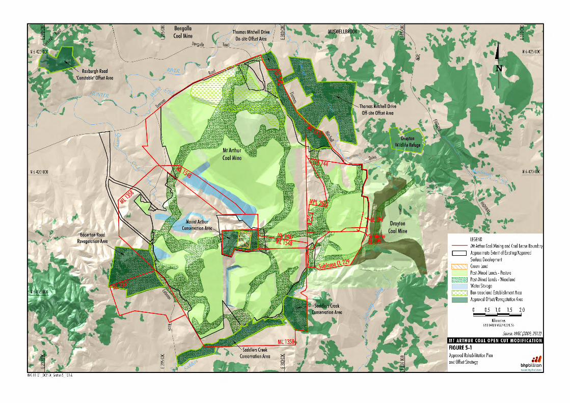
The conceptual final landform shown on Figure 5-1 and the proposed ecological offsets strategy, discussed in Section 5.2, provide consideration of all of the above objectives and the land use objectives of the Muswellbrook LEP (MSC, 2009).
5.1.5 Final Landform It is anticipated that mining at the Mt Arthur Coal Mine will continue to the west beyond 2026 pending subsequent Planning Approvals. In the unlikely event that mining does cease at the Mt Arthur Coal Mine in 2026, the following strategy will be implemented to ensure the minimisation of mine voids and the creation of an acceptable post-mining landform. The conceptual final landform provides an integrated landscape that is consistent with the Synoptic Plan (Andrews, 1999) and aims to link existing vegetation communities with mine rehabilitation areas to provide fauna movement corridors for the movement of fauna. These proposed corridors are consistent with, and will further complement both the Synoptic Plan and the final landforms of surrounding mining operations (Figure 5-1) (HVEC, 2009). Void Use and Management Post-mining, the final voids will be utilised for water storage. Void locations and respective catchment boundaries within the conceptual final landform are shown on Figure 5-1. Alternate uses for the voids will be considered as part of the Final Void Management Plan. Final void catchment areas of the final voids will be minimised post-mining to protect against external flooding, with surface flow runoff from most rehabilitated and revegetated areas being directed to the local drainage network. All areas, with the exception of the final void catchments, will be free draining. The aim of this drainage design is to maintain effective catchment contribution and yield to the Hunter River following the cessation of mining (BHP Billiton, 2012j). The low wall slopes of the final void landform will be designed with an overall slope of around 18 degrees (o). The final void landform will be rehabilitated with vegetation species that are appropriate for the complex landform. Final void highwalls will also be rehabilitated using the best reasonable and feasible rehabilitation technologies available and revegetated with species that are appropriate for its steepness, aspect, and water retention capabilities (BHP Billiton, 2012j). A Final Void Management Plan will be prepared in accordance with regulatory requirements as part of the closure planning process to integrate the documentation of void management strategies.
Mt Arthur Coal Open Cut Modification – Environmental Assessment
5-6
Overburden Emplacement Area The key components of the final landform over the areas of active mining and overburden emplacement include (BHP Billiton, 2012j): • Mt Arthur North overburden emplacement
height to an average height of 360 m AHD (maximum height of 375 m AHD to create visual relief on the overburden emplacement area);
• development of Bayswater No 3 (Saddlers Pit) overburden emplacement height up to 250 m AHD;
• development of Drayton sub-lease emplacement area up to an elevation of 290 m AHD (part of South Pit extension); and
• development of an out-of-pit overburden emplacement area up to an elevation of 360 m AHD.
Coarse reject will continue to be co-disposed within overburden emplacement areas or utilised in the construction of the tailings dams, stockpiles, pads or other site based infrastructure. The conceptual final landform design for the Mt Arthur Coal Mine has been developed to maximise consistency with the surrounding landscapes and ensure long-term sustainability and stability, with a maximum design height of approximately 375 m AHD and slopes generally less than 10o (and up to a maximum slope of 18o). In accordance with HVEC’s objectives for mine rehabilitation, the final landform will be designed to promote visual characteristics that are consistent with the surrounding environment and to result in a class of land capability that is comparable to that of the pre-mining landscape (HVEC, 2009). Water Management Areas Water management for the final landform will involve the reconstruction of a channel in the north-west of the Mt Arthur Coal Mine through to Denman Road as shown in the Mt Arthur Coal Consolidation Project EA. This may be reconsidered in future environmental assessments if mine life is extended.
A flood protection bund will be constructed between Denman Road and the Consolidation Project EA boundary where the topography is lower in elevation than the 1955 peak flood level in the Hunter River. Water run-off from the rehabilitated landform will be directed into channels that flow into the existing natural drainage pattern around the mine. The volume of water run-off will vary depending on local weather conditions and storm activity. Temporary sediment controls, such as the use of gabions, geotextiles, hay bales, sediment control fencing techniques, and similar techniques will be integrated with more permanent vegetation and engineering strategies to achieve landform stability (BHP Billiton, 2012j). The final landform drainage pattern will be designed and revegetated to achieve long-term stability and erosion control, harmonise with more general rehabilitation and revegetation strategies and integrate with surrounding catchments. Reconstructed creek lines will be revegetated with species prevalent within the existing creek channels. Reconstructed creek channels will be established in accordance with best practice standards at the time of construction (BHP Billiton, 2012j). Temporary stabilisation measures may also be required. Reconstructed creek design will include significant areas of rehabilitated overburden and other mine areas to ensure that the reconstructed channels are stable in a wide range of flows. To achieve rapid stabilisation, particularly in high flow scenarios, quick establishing pasture species will be used. There has been extensive use of pasture species for this purpose at Mt Arthur Coal Mine and other mines, and techniques are well developed. These areas will be protected from incompatible land use activities such as over grazing which may damage their integrity (BHP Billiton, 2012j). Offset Areas Existing offset areas are described in Section 4.6.1. The existing rehabilitation strategy has been designed to integrate rehabilitation areas with these offset areas. For example, a woodland corridor is proposed to link site rehabilitation areas to the Thomas Mitchell Drive off-site offset area (Figure 5-1).
Mt Arthur Coal Open Cut Modification – Environmental Assessment
5-7
5.1.6 Decommissioning Activities All surface infrastructure at the Mt Arthur Coal Mine will be removed from the site unless a documented post-mining use has been identified and agreed with relevant stakeholders. Consequently, disturbed areas associated with existing infrastructure will be managed and revegetated generally in accordance with the techniques discussed in Table 5-1.
5.1.7 Final Land Use Where possible, rehabilitation planning at Mt Arthur Coal Mine will attempt to maximise opportunities for a diverse post-mining landscape and range of land uses. It is proposed that final land uses will include pastoral, commercial forestry, recreation and/or wildlife habitat opportunities. The conceptual location of proposed native woodland and forest communities on rehabilitated lands is consistent with the DPI’s Synoptic Plan (Andrews, 1999).
5.1.8 General Rehabilitation Procedures The rehabilitation procedures at the Mt Arthur Coal Mine include: • decommissioning;
• landform establishment;
• growing media development; and
• ecosystem establishment. The following broad criteria will continue to be applied to all rehabilitation practices at the Mt Arthur Coal Mine, including (HVEC, 2009): • Revegetation will be conducted following the
reshaping, topsoiling and ripping of disturbed areas. Native species endemic to the local area will be used wherever possible.
• The overall aim of the rehabilitation programme is to return the post-mining landscape to its pre-mining overall level of land capability class. Additionally, it is proposed to increase the average percentage of woodland to improve the habitat value and to provide shade and shelter for stock.
• Generally, the flatter longer slopes of the reshaped areas will be sown to pasture while the steeper sections and those which adjoin treed areas and watercourses will be planted or sown to grasses, trees and shrubs. Initial pasture and cover crop sowings will temporarily stabilise steep slopes prior to tree plantings and sowings.
• Native grass species typical of the local area will be used in pastoral grassland establishment. Improved pastures and occasional forage crops will also be considered on areas of Class IV land.
In addition to the above ground criteria, the BRMP contains detailed, quantitative performance criteria designed to gauge the success of the rehabilitation practices with respect to the completion objectives in Table 5-1 and 5-2. Rehabilitation monitoring results will be used to assess progress against these criteria as discussed further in Section 5.1.9.
5.1.9 Rehabilitation Monitoring It is essential to monitor rehabilitation development and address rehabilitated areas not meeting the criteria presented in Tables 5-1 and 5-2. As such, identification of maintenance is an important objective of the monitoring programme and the continuous improvement process. Good initial planning and rehabilitation practice will minimise the need for remedial maintenance. Until mining leases are relinquished, broadscale field inspections will be undertaken of site-wide rehabilitated areas. These inspections will assess maintenance requirements, such as revegetation works, sedimentation and erosion control, and site safety. Monitoring programme results, maintenance activities, and any refinement of rehabilitation or monitoring methodology will be reported in the site’s AEMR. Further details on the monitoring, site security and maintenance programmes are provided in the BRMP.
Mt Arthur Coal Open Cut Modification – Environmental Assessment
5-8
5.2 REHABILITATION CHANGES RELEVANT TO THE MODIFICATION
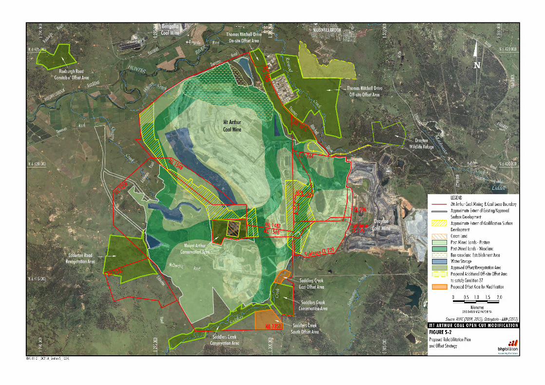
Figure 5-2 shows the proposed Rehabilitation Plan and Offset Strategy for the Modification. The Modification would result in very few changes to the Rehabilitation and Offset Strategies and the changes that would occur are as follows: • Saddlers final void would be filled in as a result
of continued investigation by Mt Arthur Coal.
• Additional offset areas would be incorporated into the existing Saddlers Creek offset area.
• Reclassification of some Post Mined Lands – Pasture to Post Mined Lands – Woodland.
• Reclassification of some Post Mined Lands – Woodland to Post Mined Lands – Pasture.
• Following completion of mining, Whites Creek would be re-established to drain off-site in accordance with existing conceptual rehabilitation principles.
As the Modification involves only minor changes to the Rehabilitation and Offset Strategies, the existing rehabilitation techniques as outlined in the Rehabilitation Strategy, BRMP and this document would continue to be implemented for the modification. The Rehabilitation Strategy, BRMP and any other relevant plan or strategy would be revised, in consultation with the relevant authorities, upon approval of the Modification in order to accommodate the changes outlined above and shown on Figure 5-2. Consistent with the above, the overall number of final voids would be reduced by filling in the Saddlers final void. As described in Appendix C, the McDonalds and Belmont voids would be used as water storages throughout operations and post-mining.
5.3 FUTURE LANDSCAPES DESIGN PROJECT
HVEC’s future rehabilitation research, design, planning, approval and implementation is subject to the outcomes of the FLDP. The FLDP is a HVEC initiative to investigate, develop and deliver a more acceptable and integrated landform that is compatible with the surrounding natural landscape. The key objective of the FLDP is to develop a final landform that addresses stakeholder concerns, is safe and stable, and generates little or no impact on production or operational efficiencies during its development or ongoing maintenance. The FLDP focus areas include (but are not limited to): • macro and micro topographic relief research
and geofluvial consideration;
• landform height and stability;
• dump development viability;
• hydrology, soil stability;
• erosion control;
• vegetation and ecosystem function design;
• visual relief and simulations; and
• noise and air quality consideration during dump development.
It is anticipated that phase one (research and design options) of the FLDP would be completed in approximately 18 months. Following analysis of design options, consultation would be undertaken with key regulatory authorities and other stakeholders regarding the proposed changes to final landscape/ landform resulting from the outcomes from the FLDP.