Embed Size (px)
Citation preview

B7 - COBAKI LAKES

THIS PAGE IS BLANK

Table of Contents
Contents i
B7 - COBAKI LAKES ........................................................................................................... 1
B7.1 INTRODUCTION ................................................................................................. 1
B7.1.1 Aims of this Section.......................................................................................... 1
B7.1.2 Land to which this Section applies ................................................................... 1
B7 - Map 1 ......................................................................................................................... 2
B7 - Map 2 ......................................................................................................................... 3
B7.2 HOW DOES THIS SECTION WORK?................................................................. 4
B7.2.1 What does this Section consist of? .................................................................. 4
B7.2.2 Why has this approach been selected? ........................................................... 4
B7.2.3 How to use this Section.................................................................................... 4
B7.2.4 How does this Section relate to other Sections and Environmental Planning Instruments? .................................................................................................... 5
B7.2.5 How does the Plan relate to the development application process? ................ 5
B7.3 MANAGEMENT STATEMENTS.......................................................................... 6
B7.3.1 General ............................................................................................................ 6
B7.3.2 Community Facilities ........................................................................................ 6
B7.3.3 Road Hierarchy ................................................................................................ 6
B7 - Map 3 ......................................................................................................................... 8
B7.3.4 Sewage Treatment Management Statement.................................................. 10
B7.3.5 Water Catchment and Stormwater System .................................................... 11
B7 - Map 4 ....................................................................................................................... 13
B7 - Map 5 ....................................................................................................................... 14
B7.3.6 Open Space Management Statement ............................................................ 15
B7.3.7 Bushfire Management Plan............................................................................ 20
B7 - Map 6 ....................................................................................................................... 21
B7.3.8 Management Plan for Community Facilities ................................................... 22
B7.3.9 System of Multi-Purpose Trails ...................................................................... 22
B7 - Map 7 ....................................................................................................................... 23
B7 - Map 8 ....................................................................................................................... 24
B7.3.10 Cattle Dip Management Plan...................................................................... 25
B7.3.11 Section 94 Contributions Plan .................................................................... 25
B7.3.12 Staging Plan ............................................................................................... 26
B7.3.13 Management Plan for Soil Erosion during Construction ............................. 28
B7 - Map 9 ....................................................................................................................... 29

Table of Contents
Contents ii
B7 - Map 10 ..................................................................................................................... 30
B7.3.14 Landfill on Flood Prone Land...................................................................... 31
B7.3.15 Scenic Drive ............................................................................................... 31
B7.4 DEVELOPMENT IN URBAN PRECINCTS........................................................ 32
Figure 1............................................................................................................................ 33
B7.4.1 Precinct One - The Sand Ridge ..................................................................... 33
B7.4.2 Precinct Two - The Knoll ................................................................................ 34
B7.4.3 Precinct Three - Piggabeen ........................................................................... 34
B7.4.4 Precinct Four - The Foothills .......................................................................... 35
B7.4.5 Precinct Five - The Plateau............................................................................ 36
B7.4.6 Precinct Six - Valley West .............................................................................. 36
B7.4.7 Precinct Seven - Valley East .......................................................................... 37
B7.4.8 Precinct Eight - East Ridge ............................................................................ 38
Figure 2............................................................................................................................ 38
B7.4.9 Precinct Nine - Town Centre .......................................................................... 39
B7.4.10 Precinct Ten - The Entrance....................................................................... 39
B7.5 DEVELOPMENT IN OPEN SPACE AND RECREATION PRECINCTS ............ 40
Figure 3............................................................................................................................ 41
B7.5.1 Precinct Eleven - Golf Course and Community Facilities ............................... 41
B7.5.2 Precinct Twelve - Open Space (Floodplain) ................................................... 42
B7.5.3 Precinct Thirteen - Open Space (Escarpment)............................................... 42
B7.5.4 Precinct Fourteen - Open Space (Mt Woodgee) ............................................ 43
B7.6 ENVIRONMENTAL DESIGN ELEMENTS......................................................... 43
B7.6.1 Community Design......................................................................................... 43
B7.6.2 Precinct Densities .......................................................................................... 46
B7.6.3 Landscape Philosophy ................................................................................... 46
B7.6.4 Lot Size and Orientation................................................................................. 47
Figure 4............................................................................................................................ 48
Figure 5............................................................................................................................ 49
B7.6.5 Building, Siting and Design ............................................................................ 49
Figure 6............................................................................................................................ 50
Figure 7............................................................................................................................ 51
Figure 8............................................................................................................................ 51
Figure 9............................................................................................................................ 53
Figure 10.......................................................................................................................... 54

Table of Contents
Contents iii
Figure 11.......................................................................................................................... 55
Figure 12.......................................................................................................................... 56
B7.6.6 Private Open Space ....................................................................................... 56
Figure 13.......................................................................................................................... 57
Figure 14.......................................................................................................................... 58
B7.6.7 Vehicular Movement Network ........................................................................ 58
Figure 15.......................................................................................................................... 59
Figure 16.......................................................................................................................... 59
B7.6.8 Pedestrians and Cyclists................................................................................ 59
B7.6.9 Streetscape.................................................................................................... 60
B7.6.10 Vehicle Parking........................................................................................... 61
B7.6.11 Utilities ........................................................................................................ 61
B7.6.12 Environmental Protection ........................................................................... 61
B7.7 DEFINITIONS.................................................................................................... 62


SECTION B7 – COBAKI LAKES
Page 1
B7 - COBAKI LAKES
B7.1 INTRODUCTION
B7.1.1 Aims of this Section • Provide a "user-friendly" document for individuals and organisations involved
in the planning, development and management of Cobaki Lakes;
• Provide a single, comprehensive and integrated set of objectives, criteria and measures which accord with Shire and regional planning aims and which address all aspects of residential and non-residential development on site;
• Ensure that the natural features and the environmentally sensitive areas are not adversely affected by future development;
• Ensure that development has minimal impact upon the natural drainage patterns, water regimes and water quality;
• Provide for the widest possible choice of housing and residential lots;
• Ensure cost-effective residential development reflecting appropriate community standards for health, safety and amenity;
• Ensure the optimal utilisation of Tweed Shire's scarce residential land by achieving an average net dwelling density of 14-16 dwellings per gross hectare;
• Facilitate the logical staging of development on the site in order to allow a co-ordinated approach to social and service infrastructure provision and a high standard of provision thereof;
• Establish a set of parameters which are based on professional input and research that has been undertaken, to facilitate a sustainable natural and man-made environment for the social benefit of the Tweed Shire.
• Set the parameters to guide the implementation of the Cobaki Lakes Community Development. This Section recognises the site's unique characteristics through the identification of precincts (see B7 – Map 2).
• Reflect and facilitate the implementation of a scheme which balances unique site characteristics with a development form, intent and density which optimises the development opportunities afforded.
B7.1.2 Land to which this Section applies This Section applies to land identified by the bold line as shown on B7 – Map 1. This area, known as Cobaki Lakes, is adjacent to the Queensland/NSW border in the north-east of NSW. The site itself is bounded by a narrow Crown Reserve and the Queensland/NSW border to the north, Crown Wetlands and Cobaki Creek to the east, Crown Reserve and private land-holdings to the west and Piggabeen Road and other private land holdings to the south.

SECTION B7 – COBAKI LAKES
Page 2
B7 - Map 1

SECTION B7 – COBAKI LAKES
Page 3
B7 - Map 2

SECTION B7 – COBAKI LAKES
Page 4
B7.2 HOW DOES THIS SECTION WORK?
B7.2.1 What does this Section consist of? This Section contains four specific Clauses which can be readily identified as follows:
OVERALL AIMS
MANAGEMENT STATEMENTS
PRECINCT OBJECTIVES
DESIGN ELEMENTS
The overall aims indicate the brief for the preparation of this Section and its intent. The Management Statements provide the parameters to establish, maintain and monitor the essential physical attributes of the site. The precinct objectives recognise the particular characteristic of each locality and the natural features that need to be an integral part of the design process, while the design elements utilise the Australian Model Code for Residential Development and provide the parameters for pleasant and functional residential settings.
B7.2.2 Why has this approach been selected? This approach has been selected to simplify the planning controls and to assist the reader to understand the document. This Section highlights the physical attributes of the site and the particular characteristics which identify each of the precincts. The Management Statements will ensure that the natural and man-made attributes will be maintained in harmony with future development, whilst the precinct objectives and design elements will set the parameters for development in each of the precincts.
B7.2.3 How to use this Section This Section must be read in conjunction with all current LEPs applying to Cobaki Lakes. Before preparing a development or building application, applicants should consult with Council's Planning or Building Sections to ensure that the type of development being proposed is appropriate. This Section will serve a different purpose for potential residents, Council officers, and public authorities. Potential residents may principally be concerned with the characteristics and objectives for their particular precinct. These parameters will provide a good indication of the intended development. Applicants and developers should concern themselves with the overall aims of this Section, the intentions for the particular precincts, the various design elements, and how the physical features are to be managed on an ongoing basis. This should ensure that the development proposed will meet the various parameters. Councils and public authorities will principally be concerned that the development proposed meets the intentions of this Section and those authorities' service provision programs. This will incorporate an evaluation of the objectives

SECTION B7 – COBAKI LAKES
Page 5
and guidelines contained in this DCP together with a consideration of other related LEPs and other Sections of this DCP. The rationale behind this Section is contained in Council's LES for Cobaki Lakes, as well as documentation relating to DCP amendments to this Section as may, from time to time, be demonstrated as appropriate.
B7.2.4 How does this Section relate to other Sections and Environmental Planning Instruments? Where an inconsistency arises between this Section and any environmental planning instrument applying to the same land, the provisions of environmental planning instrument prevails. An environmental planning instrument means a State Environmental Planning Policy, a Regional Environmental Plan or a Local Environmental Plan. Where there is an inconsistency between this Section and any other Sections, the provision of this Section shall prevail. Other relevant Council documents include:
Section A1 - Residential and Tourist Development Code Section A2 - Site Access and Parking Code Section A3 - Development of Flood Liable Land Section A4 - Advertising Signs Code Section A5 - Subdivision Manual
The provisions and intent of this Section prevail over these documents if there is an inconsistency. This Section has been prepared as part of a masterplanning exercise which incorporated a number of planning studies. These studies are summarised and appraised in the Local Environmental Study (LES) accompanying the rezoning of Cobaki Lakes, which was prepared by the Tweed Shire Council. In preparing an application for development there are a number of specific steps that should be followed: Step 1: Check the zoning of the site under Tweed LEP 2000 to ensure that the
proposed development is permissible and to determine what related provisions apply.
Step 2: Establish what other Sections of this DCP or Policies apply to the site (B7.2.4)
Step 3: Follow the applicable design guidelines (Clauses B12.2.1 – B12.2.5 inclusive) and refer to other applicable Sections and Policies to prepare your application. It is these components that Council will use to assess any development proposal.
Step 4: Discuss your final application with Council staff then lodge it for determination.
B7.2.5 How does the Plan relate to the development application process? This Section will be considered by Council in assessing development proposals. Virtually all development in Cobaki Lakes requires consent and must be the subject of a development application. Council may refuse consent to a development which does not comply with this Section, or may modify the development by way of

SECTION B7 – COBAKI LAKES
Page 6
conditions so that it does comply. Council will also consider this Section in assessing how development satisfies the objectives set out in the Tweed LEP. The Council also has the ability to approve development that does not comply with the provisions of this Section. It is recognised that this Section is a general guide for the area and a standard may be inappropriate in a particular case. Council will consider a variation provided that the overall objectives are maintained. Where a proposed development does not comply with a provision of this Section it is essential that the applicant sets out the reasons in the documentation supporting the application.
B7.3 MANAGEMENT STATEMENTS
B7.3.1 General This Clause will address the options for land ownership and the various management systems or plans which have been prepared in the form of statements. To simplify a wealth of research material, the Management Statements have been prepared in a question and answer format. In some instances these statements will need to be developed into Management Plans. The Management Plans shall be prepared by the developer and incorporated into this Section, as an amendment, prior to the lodgement of the related development applications. At this stage all Maps included in this Section are only indicative.
B7.3.2 Community Facilities There are three distinct options for the areas designated for open space, community facilities and roads which will determine the medium and long term management of the site. The first option is that these facilities are dedicated, sold or otherwise transferred to Council to meet the requirements of Section 94. The second option is that these facilities are retained by the present and future owners of the site by way of a Community Title and that body assumes the responsibility for ongoing maintenance. The third option is a combination of options one and two with some facilities being handed over to Council, and others forming part of a Community Title. A decision on the preferred option will need to be made and submitted to Council at the time of lodgement of the development applications.
B7.3.3 Road Hierarchy What is the Road Hierarchy? The road hierarchy is the classification of roads ranked by function within a network which enables vehicular access from each component of the development to other components and to external regional facilities (see B7 – Map 3). What will it achieve? The objective of the Road Hierarchy is:
To effect a satisfactory balance between access (both local and in the regional context) and amenity, meeting safety objectives, high environmental standards and separating through traffic, local traffic and pedestrians.
SECTION B7 – COBAKI LAKES
Page 7
The Road Hierarchy will provide the design framework to safely accommodate traffic volumes and to ensure residential amenity is maintained. This will be achieved by connecting access roads to a network of progressively higher volume roads, namely residential, recreational and commercial, and shopping collector roads, to ultimately integrate with regional distributor roads. The Road Hierarchy shown recognises and facilitates the establishment of a Scenic Drive through the site, consistent with Council's Shire - wide strategy. How will it be installed? With the exception of the future connector road to Bilambil Heights, all roads within the development are to be provided by the relevant developer and shall be constructed at the developer's cost to local authority construction specifications. The intended street, footpath and parking guidelines are included (see Table 1). These guidelines have been generated from Section A5 – Subdivision Manual and the Australian Model Code for Residential Development. Roads will be constructed of asphalt sealed gravel pavements, concrete, or block pavers. Pavement edge treatment shall be concrete edge strip or roll over kerb for access streets to upright kerbs for collector roads. The major Boyd Street/Piggabeen Road distributor road shall wherever possible have gravel shoulders with no other edge treatment. Parking will not be encouraged on this road nor will direct vehicular access to residential properties. Who will be responsible? The developer shall be responsible for establishing the necessary road reserves for an eventual four lane road from Boyd Street to the Town Centre, excluding the proposed Tugun Bypass. The developer shall dedicate the four lane road reserve within the Cobaki property from the Town Centre. A four lane road reserve shall be provided through the Crown Lands to Boyd Street, of which two lanes shall be provided and constructed by the developer. The developer shall construct the two lane road required to service the Cobaki Lakes development from Piggabeen Road to the Town Centre through to Boyd Street and the Gold Coast highway to the satisfaction of all relevant authorities.

SECTION B7 – COBAKI LAKES
Page 8
B7 - Map 3

SECTION B7 – COBAKI LAKES
Page 9
TABLE 1
TABLE 1: GUIDELINES FOR STREET CHARACTERISTICS STREET TYPE
MAXIMUM TRAFFIC VOLUME
CATCHMENT (MAXIMUM DWELLINGS)
DESIGN SPEEDS
TRAVELWAY MINIMUM WIDTHS
MINIMUM VERGE WIDTHS
MINIMUM ROADWAY RESERVATION
MEDIAN ON-STREET PARKING (MINIMUM)
FRONTAGE ACCESS
FOOTPATH PROVISION
BUS ROUTES
ACCESS PLACE
100vpd
300vpd
10
30
20km
25km
4.5m (2)
5.5m (3)
3.5m (5)
3.5m (5)
11.5m
12.5m
No
No
1 per 2
included in the travelway
Yes
Yes
No
1.2 desirable (one side)
No
No
ACCESS STREET
2000vpd 200 40km 6.0m 4.0m (5) 14.0m No 1 per 2 Yes 1.2 desirable (one side)
No
RESIDENTIAL COLLECTOR
3000vpd
(plus)
- 50/55km 7.0m 4.0m (5) 15.0m No 1 per 2 Yes (4) 1.2m or 1.8m
Yes
SHOPPING COLLECTOR
5000 - 7000vpd
- 60km Dual carriage way (3.0m lanes)
5.0m 30.0m Desirable
Permitted (4)
No Undesirable (provide alternative)
Yes
DISTRIBUTOR
75000vpd - 60-80km Dual carriage way (3.5m lanes)
5.0m 40.0m Desirable
Generally not permitted
No Undesirable (provide alternative)
Yes
(1) The above guidelines have been generated from relevant traffic planning documents, including the Tweed Shire Council guidelines for road hierarchy and the Australian Model Code for Residential Development.
(2) Functionally based on private ownership catchment of up to 10 dwellings.
(3) Functionally based on public ownership catchment of up to 30 dwellings.
(4) Permitted but may be constrained by traffic control devices.
(5) May be reduced to 2 metres in special circumstances on steep land on high side of carriageway.

SECTION B7 – COBAKI LAKES
Page 10
The additional two lane reserve and Tugun By-Pass underpass through Crown lands to Boyd Street, required to service future development of Bilambil Heights/Scenic Drive, will be dedicated through Section 94 contributions. The developer shall dedicate a two lane road reserve within the Cobaki property from the Town Centre to Cobaki Creek for the future Bilambil Heights connector road. This road shall be located to the east of Precinct 1 to provide for a green belt buffer between it and urban development. The developer shall also provide or contribute to adequate Tick Control facilities to the satisfaction of the Board of Tick Control.
B7.3.4 Sewage Treatment Management Statement What is the Sewage Treatment Management Statement? The Sewage Treatment Management Statement will explain how sewage from the Cobaki Lakes project will be conveyed and treated and how treated effluent will be returned for the landscape irrigation of the project. What will it achieve? The objective of the Sewage Treatment Management Statement is:
To ensure the environmentally safe collection and disposal of domestic water borne wastes.
All sewage generated from the Cobaki Lakes project will be collected at a central pump-station located within the site and discharged via a rising main for treatment at a Council operated treatment plant. Treated effluent may be pumped back to Cobaki Lakes for irrigation of the golf course and surrounding landscape. This supply would be utilised only when required. How will it be installed? The necessary conveyancing system to the Gollan Drive pump-station is to be installed by the developer. All other system improvements will be constructed by Council under headworks contributions. If required, the return treated effluent supply would be totally funded and constructed by the developer. How will it be monitored? If utilised, the quality of the treated effluent to be re-used for irrigation is to meet the relevant criteria of the Environment Protection Authority (EPA) as outlined in the "Environmental Design Guidelines for the Use of Recycled Water in N.S.W." The facility and treatment standards stipulated by the Public Works Department (PWD) and the DEC shall be met and continually monitored in both options. Who will be responsible? The sewage conveyancing and treatment system will be maintained, owned and operated by Council upon acceptance after construction. The return treated effluent system will be privately maintained by the developer and most probably jointly operated with Council.

SECTION B7 – COBAKI LAKES
Page 11
B7.3.5 Water Catchment and Stormwater System What is a Water Catchment and Stormwater System? A water catchment and stormwater system is a network of water pollution control ponds, freshwater lakes, connected meadowlands/drainage paths and re-established melaleuca woodland, in which stormwater from all developed portions of the site is directed (see B7 – Map 4). What will it achieve? The objective of the Water Catchment and Stormwater System is:
To ensure that, following implementation of the Cobaki Lakes development, there is no increase in the levels of contaminants leaving the site. Any stormwater from the site entering the Cobaki Creek at nominated monitoring stations should seek to achieve the following qualities or better than: dissolved oxygen > 80% saturation; total nitrogen < 0.50 mg/L; total phosphorous < 0.20 mg/L; suspended sediment < 50 mg/L; salinity < 5 g/L; pH > 5.0 pH. Actual site specific water quality performance standards should be determined following establishment of an on site baseline water quality monitoring program.
Actual standards to be achieved will be ratified with Council in water quality management plans to be prepared prior to construction approval for each stage of development. Stormwater treatment will be achieved principally by the controlling of runoff and maintaining water quality throughout the network. The surface patterns of stormwater run-off to low wetlands and heathland areas will be maintained. Proposed land fill operations will be modelled in the first instance and monitored carefully on completion. How will it be installed? A detailed design of the system, on a sub-catchment basis, will be prepared prior to the lodgement of the related development application to ensure the practicability from a stormwater transportation viewpoint and to reduce the risk of flooding. The system will be designed in accordance with the EPA publications entitled "Water Quality Goals and Objectives for New South Wales" (1990), "Water Quality Criteria for New South Wales" (1991) and "Pollution Control Manual for Urban Stormwater" (1989), and Section A5 – Subdivision Manual of this DCP. Suitable plant species (macrophytes) will be established in the water pollution control ponds and the selection and placement of these species determined and supervised by appropriately qualified personnel. How will it be maintained? Periodic harvesting of macrophytes, revegetation with both submerged and emergent species to minimise the likelihood of algal blooms and to reduce the nutrient status of the system, accompanied by de-sludging/dredging of the lakes and ponds, will be required. To ensure water quality in Cobaki Lakes is maintained, an on-going program of monitoring water quality in Cobaki Creek is proposed. This monitoring program will involve the following stages:
• review of available data (already completed);

SECTION B7 – COBAKI LAKES
Page 12
• design and implementation of a statistically valid baseline monitoring program;
• implementation of construction phase, and operational phase monitoring; and
• periodic reporting, review of results, modification of the monitoring program, and recommendations with respect to on-site system alterations.
Who will be responsible? The developer/Body Corporate/Management Authority of the Cobaki Lakes project will be responsible for maintaining and monitoring the Water Catchment and Stormwater System in the initial stages of development. The Environmental Officer to be engaged by the developer, will oversee the implementation of the system. This responsibility may be directed to the Tweed Shire Council upon demonstration of a practical, workable and efficient stormwater system.

SECTION B7 – COBAKI LAKES
Page 13
B7 - Map 4

SECTION B7 – COBAKI LAKES
Page 14
B7 - Map 5

SECTION B7 – COBAKI LAKES
Page 15
B7.3.6 Open Space Management Statement What is the Open Space Management Statement? The Open Space Management Statement provides a general overview of the quantity, type and location of open space to be provided in Cobaki Lakes, and sets up the framework for more detailed plans for particular areas (see B7 – Map 5). What will it achieve? The objective of the Open Space Management Statement is:
To ensure adequate provision of public open space and protect areas of environmental significance.
This Section for Cobaki Lakes provides for approximately 260 hectares plus hillslope land of open space. Public open space incorporates approximately 68 hectares or 25% of total open space provided. A large proportion of the public open space is intended for passive recreation space and includes the Meadowland and Heathland of Precinct 12 and the Mt Woodgee area known as Precinct 14 (see Table 2). How will it be achieved? Separate Management Plans are to be provided for the escarpment, the heathland and Scribbly Gum area, the flood-plain, Mt Woodgee, the private golf courses and wildlife corridors (see below). The management plans are to be prepared and submitted as part of any development application insofar as they relate to or interact with the respective Management Plan areas by virtue of, inter alia, proximity or function. The Escarpment Management Plan What is the Escarpment Management Plan? The Escarpment Management Plan is a set of procedures to protect the ecologically significant area known as Precinct 13 in this Section. What will it achieve? The objective of the Escarpment Management Plan is:
To retain existing vegetation, facilitate fauna movement and bushwalking, and provide for bushfire maintenance at the same time retaining a topographic and vegetation backdrop for the site.
TABLE 2 OPEN SPACE (Public & Private)
PUBLIC OPEN SPACE
Mt Woodgee precinct 23.3ha
Escarpment precinct 23.9ha
Community open space (town centre) 16.2ha
Habitat 18.6ha
Wetlands 9.3ha
Cobaki Creek buffer 2.0ha

SECTION B7 – COBAKI LAKES
Page 16
PUBLIC OPEN SPACE
Community open space (south) 56.4ha
Wildlife Corridor 7.0ha
156.7ha
PRIVATE OPEN SPACE
Golf course 68.7ha
Private school 41.0ha 109.7ha
TOTAL OPEN SPACE 266.4ha Note - Areas shown are gross (ie, inclusive of the area required for any roads) The landform elements and woodland vegetation of the escarpment provide scenic amenity, habitat diversity and soil stability. The existing vegetation and landform elements are to be protected and provision made for an integrated, sequential system of low-key, multi-purpose trails for passive recreation and educational experience. How will it be installed? Selective clearing is to be pursued, primarily to reduce or minimise fire risk. Also, appropriate reafforestation should be carried out for the establishment of steady state conditions. Who will be responsible? Council or a community developer will be responsible for the maintenance of the escarpment area. The developer will provide the area in a steady state prior to the land being transferred to either Council or a community association. Heathland and Scribbly Gum Management Plan What is the Heathland and Scribbly Gum Management Plan?
The Heathland and Scribbly Gum Management Plan is a set of procedures detailing the retention of tree and shrub heath associations, and the retention of selected areas of Scribbly Gums. What will it achieve? The objective of the Heathland and Scribbly Gum Management Plan is:
To facilitate the retention of tree and shrub heath associations and retain the Scribbly Gums as a parkland component to residential development.
This plan will include the retention of important wildlife habitats and incorporate educational and recreational components. It will also enable the public to enjoy and learn more about their environment. Generally, the plan will not permit development within 20 metres of the Wetland boundary as defined under State Environmental Planning Policy No 14 (as amended) or within 20 metres of the adjoining Environmental (Habitat) zone boundary.

SECTION B7 – COBAKI LAKES
Page 17
How will it be maintained? The plan will require the clearing of some areas, replanting of appropriate species and the identification of the Scribbly Gums to be retained. The maintenance program is to be undertaken with the floodway swamps rehabilitation program. Such a program could be operated through the proposed educational centre in cooperation with Council and other relevant authorities. Who will be responsible? The developer is to undertake the establishment of the heathland area in a steady state condition providing additional planting and works together with an environmental protection/bushfire hazard buffer area as determined by the consultant ecological specialist in consultation with Council. At some future date the responsibility for the area will be transferred to Council or other authorities. Flood-Plain Swamp Management Plan What is the Flood-Plain Swamp Management Plan? The Flood-Plain Swamp Management Plan is essentially a rehabilitation program to reinstate the paper-bark and swamp oak woodland that existed on the flood-plain prior to clearing the land for grazing. What will it achieve? The objective of the Flood-Plain Swamp Management Plan is:
To rehabilitate the mangrove association together with the reinstatement and integration of the meadowland with the woodland.
The plan is to investigate the natural tidal flushing, and if found to be beneficial and practical, to implement the same, thereby promoting the rehabilitation of the fringing mangrove association, reinstate the former melaleuca woodland and integrate these communities with current meadowland. This will complement other water quality measures designed to minimise or obviate any off-site impacts to Cobaki Broadwater or Cobaki Creek. The reinstated melaleuca woodland, apart from providing an important habitat adjunct to the site and decelerating sheet flow across the lowland areas, will act as a nutrient sump thereby preventing the eutrophication or pollution of Cobaki Creek and Cobaki Broadwater. Public access throughout this area will be provided for by a system of multi-purpose trails and a horse riding circuit trail (see Clause B7.3.9). How will it be maintained? Upon transfer of the land in a steady state condition, maintenance will be undertaken by Council or DEC as an area of public open space. Who will be responsible? The developer will be responsible for the initial clearing and re-planting with Council or DEC assuming responsibility at a later stage. Mt Woodgee Precinct What is the Mt Woodgee Management Plan? The Mt Woodgee Management Plan is to contain a series of landscape and landuse controls to protect the environmental and scenic attributes of the area.

SECTION B7 – COBAKI LAKES
Page 18
What will it achieve? The objectives of the Mt Woodgee Management Plan are:
To retain and enhance the woodlands and scrub forest vegetation; To provide for an observatory/restaurant; To ensure adequate buffer area around the core forest remnant and to facilitate provision of appropriate public access, rehabilitation plantings and environmental facilities.
The plan is to program the removal of weedy species, the rehabilitation of the area with appropriate incremental species, and establish steady state conditions. Protection of existing vegetation and natural contours are to provide a scenic reserve and maintain important ecological functions and soil stability. A series of multipurpose trails may be provided leading to a possible observatory/restaurant as the summit will enable the public to enjoy the attributes of this area and experience a unique vantage position. In the event that an observatory/restaurant is developed, underground infrastructure services will be reticulated to the observatory site within the service easement to be created for the water reservoir planned within this locality. Access to the summit may be gained by walking trails, private service road or other means demonstrated as feasible and appropriate. Rehabilitation, edge plantings, weed eradication and bushfire hazard areas are to be included in the Management Plan. How will it be maintained? Upon transfer of the land in a steady state condition, maintenance will be undertaken by Council or a community association, as an area of public open space. The observatory/restaurant site and access ways would be owned and operated by a private party. Who will be responsible? The developer will be responsible for establishing steady state conditions prior to land transfer and for ensuring that the observatory/restaurant and access ways are constructed with minimal impact. Wildlife Corridor Management Plan What is the Wildlife Corridor Management Plan? The Wildlife Corridor Management Plan nominates internal and regional wildlife corridors and is to provide a range of measures to protect habitats and facilitate fauna movement (see B7 - Map 5). What will it achieve? The objective of the Wildlife Corridor Management Plan is:
To ensure plants and animals have sufficient combined habitat available to support interchange and movement of genetically viable populations over the long term.
The plan is to integrate the ecological requirements of vegetation, provide for fauna movement and assist in maintaining current drainage routes and water quality. It will facilitate fauna movement as part of the wildlife corridors linking coastal vegetation with the McPherson Ranges.

SECTION B7 – COBAKI LAKES
Page 19
A man-made corridor through the Boyd Street extension is to include a system of local native vegetation and culverts with associated fencing to both protect and permit the present patterns of faunal movement when the Boyd Street extension is constructed. The fencing will direct fauna to culverted underpasses to minimise fauna mortalities which could otherwise result from vehicle traffic. How will it be maintained? The internal corridors are to be maintained as part of the overall open space management. The Boyd Street corridor will require routine maintenance for the landscape culverts and fencing. Some pruning of vegetation around the entrance to the culverts may be necessary every one or two years. The regional corridors may require community, local and state government input with management centralised under one responsible body. Who will be responsible? The internal corridors would be expected to be maintained under the normal parks and gardens program for Tweed Shire. This could involve the Community Association together with local or state government. The regional corridors may require a combination of funding arrangements at Local, state and possibly federal level for maintenance. Golf Course Management Plan What is the Golf Course Management Plan? The Golf Course Management Plan is to provide the management procedures for maintaining the golf course areas as an integral part of the water catchment and stormwater system. What will it achieve? The objective of the Golf Course Management Plan is:
To ensure that the golf courses fulfil their role in the overall water quality and wildlife management system of Cobaki Lakes as well as providing attractive and efficiently operated recreational facilities.
This plan is to incorporate the water catchment management requirements, control chemical and pesticide applications, and include a water quality monitoring program. How will it be maintained? Treated effluent will be used for irrigation purposes and should be sufficient for the golf course fairways to require only minimal fertilisation. Only slow release fertilisers will be used on the golf course and play fields, when additional nutrients are required. Pesticide applications will be tightly controlled and kept to minimum levels through agronomic selection of grass types. Discharge waters leaving the golf course are to be monitored regularly as part of the Water Catchment Management System. This monitoring program is to be co-ordinated by the Council in association with other relevant government authorities. Who will be responsible? The Golf Course Management Plan is to be prepared by the developer in conjunction with Council, the DEC and other relevant authorities. Negotiations

SECTION B7 – COBAKI LAKES
Page 20
would then take place with suitable golf course operators who would be subject to a legally binding agreement either with the developer or Council.
B7.3.7 Bushfire Management Plan What is the Bushfire Management Plan? The Bushfire Management Plan is to specify development guidelines for development adjoining vegetated areas (see B7 – Map 6). What will it achieve? The objective of the Bushfire Management Plan is:
To reduce the risk of fire and protect wildlife habitats and private property.
This plan should nominate fire-break areas and provides for buffer zones around bush fire risk zones. Managed trails, road reserves and setback requirements will provide effective fire-breaks to adjoining areas of development. The plan will provide for emergency access routes to ensure safe passage in the event of fire and for efficient access by fire fighting vehicles. The buffer areas nominated in Section 6.12 of this Development Control Plan are to be included as bushfire hazard reduction areas. How will it be Installed? The installation of the fire management controls will incorporate:
• Monitoring of the extent, nature and condition of ground fuel loads in fire-risk areas;
• Establishment of fire danger rating systems and indices for heathland and woodland areas;
• Reduction in ground fuel loads (fallen timber) in high fire-risk areas and the removal of fire-hazard chimney trees capable of converting a ground fire to a canopy or crown fire in woodland areas provided that such trees are not confirmed as den trees for greater gliders;
• Slashing and the disposal (removal) of undergrowth from woodland areas;
• Planting of fire-retardant (less fire-susceptible) species;
• Creation of firebreaks and the slashing of perimeter and open-space grassland;
• Consultation with appropriate bodies and authorities including the Bush Fire Council, Tweed Shire Council, Forestry Commission, National Parks & Wildlife Services and the Bureau of Meteorology;
• Discipline of community awareness and education. Who will be responsible? Maintenance will become the responsibility of the owner of the land (Council or other) under the direction of the appropriate bush fire control agency.

SECTION B7 – COBAKI LAKES
Page 21
B7 - Map 6

SECTION B7 – COBAKI LAKES
Page 22
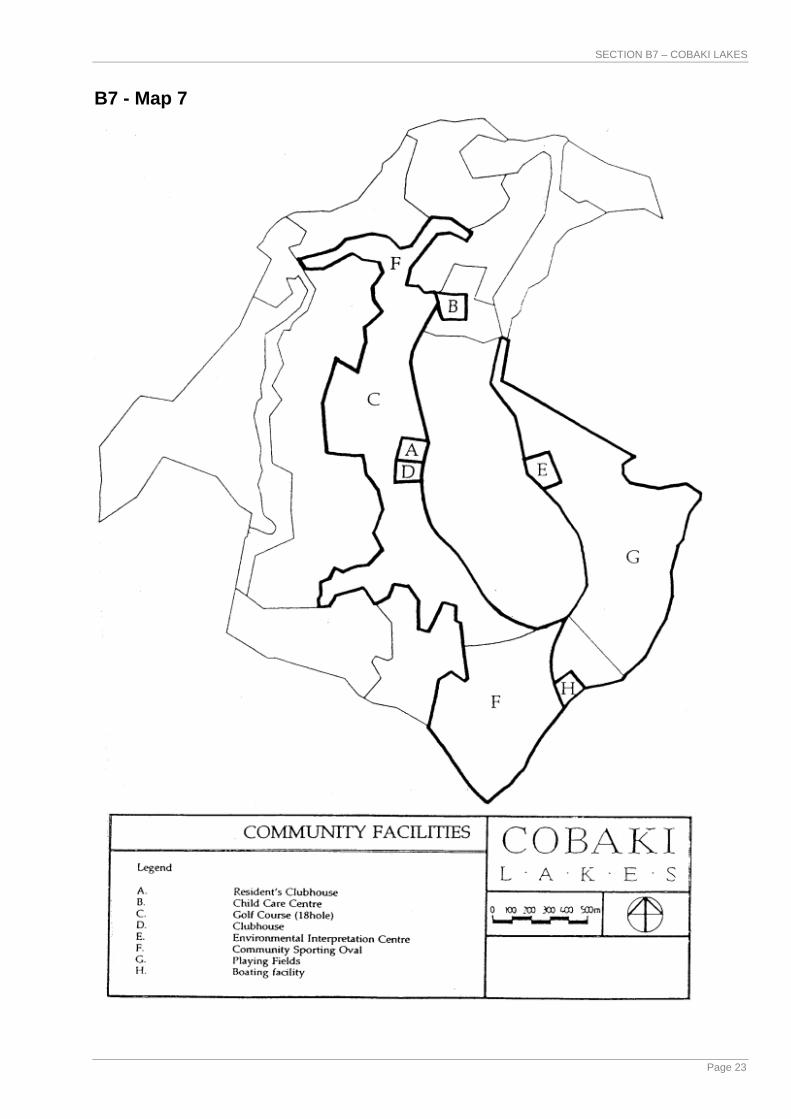
B7.3.8 Management Plan for Community Facilities What is the Management Plan for Community Facilities? This Management Plan nominates development sites for community facilities and will provide staging and funding details in accordance with Council's S94 Contribution Plan (see B7 – Map 7). What will it achieve? The objective of the Management Plan for Community Facilities is:
To ensure that appropriate sites are reserved for the provision of community facilities to adequately service the social and recreational needs of the community.
The plan nominates the location of the proposed community hall, sporting facilities, residents' clubhouse and neighbourhood parks. How will it be maintained? The responsibility for maintenance is dependent on the type of land title adopted and the desire and capacity of Tweed Shire Council to own and operate the various community and recreational facilities. The facilities proposed will be provided by the developer to satisfy resident requirements.
B7.3.9 System of Multi-Purpose Trails What is a System of Multi-Purpose Trails? The system of multi-purpose trails will allow for pedestrians, bicycles, golf buggies and horse riding free from conflict with motor vehicles (see B7 – Map 8). What will it achieve? The objective of the System of Multi-Purpose Trails is:
To provide residents and visitors with a convenient and alternative means of movement between the various site facilities, residential areas and the proposed regional cycleway network.
The multi-purpose trails are intended to accommodate pedestrians, bicycles, possibly buggies within the golf course and, in the flood-plain alongside Cobaki Creek, a horse-riding trail. The trail system will also provide an opportunity for nature viewing and boardwalks may be established through heath and wetland fringe communities, subject to the approval of relevant authorities in turn making accessible to the public the site's scenic and natural areas, thereby imparting a sense of identity and community. How will it be installed? The system of trails will be included as an integral part of the design and development of the individual precincts. Type of construction is dependent on anticipated use, with nominated cycleways constructed in accordance with standards included (see Clause B7.6.8). Who will be responsible? Trail maintenance, primarily clearing, will become the responsibility of Council, and/or the community association or private organisation responsible for the respective areas of open space.
SECTION B7 – COBAKI LAKES
Page 23
B7 - Map 7

SECTION B7 – COBAKI LAKES
Page 24
B7 - Map 8

SECTION B7 – COBAKI LAKES
Page 25
B7.3.10 Cattle Dip Management Plan What is the Cattle Dip Management Plan? The Cattle Dip Management Plan is a set of procedures to decommission and rectify the site. What will it achieve? The objective of the Cattle Dip Management Plan is:
To ensure that the contaminated area is capped and contained without risk to the environment or humans, or otherwise treated in a manner acceptable to, or required by, the Department of Primary Industry (DPI).
A final site rectification and management plan will be prepared for approval by the DPI and, if required, the DIPMAC Committee before the dip is decommissioned for development. Residential development is not appropriate within the immediate dip site location. The intended use of the area is for a golf course maintenance building which is to be built on a cement slab. A buffer area is to be provided around this facility where no residential development is to be permitted. Who will be responsible? The developer will be responsible for undertaking all remediation works in accordance with the Department of Environment and Conservation (DEC) requirements although the cost thereof will be subject to negotiation with DPI. If the proposed Tweed storage facility is to be utilised then costs will also be subject to negotiation with the DPI.
B7.3.11 Section 94 Contributions Plan What is a Section 94 Contributions Plan? The Section 94 Contributions Plan will provide a description, estimated cost and developer contribution for the following:
• Infrastructure services - roads, pathways, sewerage treatment, water supply, drainage.
• Public open space
• Community facilities - recreational facilities, residents' clubhouse, access education centre (schools).
• Contributions to various regional studies. What will it achieve? The objective of the S94 Contributions Management Plan is:
To ensure that the provision of infrastructure, public open space and community facilities is adequate for proposed development.
The Section 94 Management Plan for the whole site is to be prepared by the developer and Council prior to the lodgement of development applications for subdivision of the site as required under Section 94(7) of the EP&A Act.
SECTION B7 – COBAKI LAKES
Page 26
B7.3.12 Staging Plan What is a Staging Plan? A Staging Plan is a guide to the anticipated works program, the release of residential and non-residential precincts and the programming of general site maintenance (see B7 – Map 9). What will it achieve? The objective of the Staging Plan is:
To ensure the orderly and economic development of land, taking into account all relevant physical, social, market, infrastructural and economic factors.
An integral part of this plan is the appointment of an Environmental Officer to monitor and oversee the environmental effect of development during construction stages. The role of the Environmental officer will be approved for critical construction periods to be agreed with Council's Director of Planning & Development at Development Application Stage. This plan prioritises the intended development of the site. At this stage the plan is indicative only and subject to variation. The developer proposes to undertake Stages 1A, 1-5 concurrently to initiate the development. The developer has committed to Council to construct as part of Stage 1 a road connection between Boyd Street and Piggabeen Road. Open space and community facilities contributions for each stage will be described in a Section 94 Contributions Plan. Are there other constraints? Council, at its meeting of 7 June, 1995 resolved to adopt the Development Control Plan (DCP 17 – Cobaki Lakes) (DCP 17 preceded this Section of this DCP) amendment, as follows: 1. Restriction of the maximum size of the Cobaki Lakes Development to 3,500
units until the Tugun Bypass is completed and operational to traffic. If operational problems are observed at the Gold Coast Highway/Boyd Street intersection prior to 3,500 units being constructed. Queensland Transport will meter traffic accessing the Gold Coast Highway by restricting green time for the Boyd Street approach. If operational problems do occur the Developer will be encouraged to limit development and/or encourage development traffic to access via alternative means. Queensland Transport will not be responsible for trafic delays for traffic accessing the Gold Coast Highway via Boyd Street. This will be determined by calculating the degree of saturation for all intersection approaches of Gold Coast Highway/Boyd Street. If any approach is calculated to have a degree of saturation above 0.9 of the saturation volume (during any hour of a typical business day), operational problems will be deemed to be occurring at this intersection.
2. Queensland Transport agrees to the Interim Layout (Sketch CTG231-103-SK14) of Gold Coast Highway/Boyd Street intersection as being a suitable access during the development phase of Cobaki Lakes subject to the issues identified in Section (6) being resolved. Construction of the Ultimate Layout is required when any of the following conditions are met:- a) the release of Lot 2900 of the Cobaki Development or,
SECTION B7 – COBAKI LAKES
Page 27
b) traffic volumes on the Gold Coast Highway at Boyd Street intersection exceed 4300 vehicles/hour (peak) for two way traffic on typical business day. This may be calculated by conducting a traffic count on the Gold Coast Highway (north and south bound) immediately north of the proposed Boyd Street intersection or,
c) any approach of the Gold Coast Highway/Boyd Street intersection has greater than 0.9 of the saturation volume for that approach to that intersection.
At the time that any of the above conditions are satisfied the Developer will be required to construct the ultimate layout (as per Sketch CG231-103-SK14).
3. Queensland Transport agrees to the Ultlimate Layout (Sketch CG231-103-SK15) as being a suitable access for Boyd Street to permit development to 3500 lots of Cobaki Lakes subject to the issues identified in Section (6) being resolved.
4. The developer shall construct the interim layout for Gold Coast Highway/Boyd Street intersection to the satisfaction of Queensland Transport prior to commencement of development of Cobaki Lakes.
5. The developer shall deposit a bond with Queensland Transport prior to the development of Cobaki Lakes. The bond shall be determined as the funds required to construct the Ultimate Gold Coast Highway/Boyd Street layout. The details of the contribution shall be determined by the Developer and submitted to Queensland Transport for approval. The final quantum of the bond shall be determined by Queensland Transport.
6. The median island on the Gold Coast Highway at the median break south of Boyd Street needs extending to further prevent right turns out of Coolangatta Road. This would emphasise that there is Left out only from Coolangatta Road. This may require additional widening of the access into Coolangatta Road to accommodate turn movements. This comment is applicable to both the Interim and Ultimate layout.
Compliance with access requirements based on the assessed impact of the proposal. (Access design is to be in accordance with "AUSTROADS" Standards and to be completed prior to Council sealing survey plans). Construction within the State Controlled road reserve is to be carried out in accordance with Queensland Transport Specifications. Where deemed necessary Engineering Drawings shall be submitted for approval by Queensland Transport prior to the commencement of any external works. In addition, adds a clause to the effect that it will require a development application for the creation of en-globo lots to indicate the yield of residential lots so that the requirements of the Queensland Department of Transport to limit development to 3500 lots may be monitored. Who will be responsible? The Staging Plan (B7 – Map 9) indicates in general terms the proposed progression of development of the Cobaki Lakes site and, by association, the progressive implementation of road, water, sewer and electricity services. Special issues in the regard, as they apply to respective development parcels, will be negotiated with Council at the time of development application lodgement.

SECTION B7 – COBAKI LAKES
Page 28
The plan is to be co-ordinated by the master developer who will liaise with those responsible for particular aspects of the site development. During constructions periods to be agreed with Council's Director of Planning & Development during the development approval implementation process the Environmental Officer's responsibilities are to include managing environmentally sensitive site issues such as water quality, tree removal, earthworks and wildlife protection. The officer is also to be responsible for ongoing liaison with other statutory authorities and notifying Council, the Tweed/Byron Local Aboriginal Land Council, and DEC if any aboriginal artefacts or sites are uncovered during the construction phase.
B7.3.13 Management Plan for Soil Erosion during Construction What is the Management Plan for Soil Erosion During Construction? This Management Plan involves a set of procedures designed to minimise soil erosion during construction (see B7 – Map 10). What will it achieve? The objective of the Management Plan for Soil Erosion during Construction is:
To control and minimise the pollution caused by soil erosion of downstream waterways during the construction of the project.
The Management Plan will require the use of bunding and detention basins to minimise the discharge of silt laden runoff waters into sensitive areas such as natural waterways. The Plan will also require details of excavation and filling operations to be undertaken on the site. Once earthworks are completed, affected areas are to be topsoiled, reseeded with grass, and trees planted. Areas particularly susceptible to erosion may be turfed to ensure a speedy stabilisation of the ground. These measures will re-establish a root system and return the site to a stable condition. Any sites or areas steeper than 1:4 may need to be the subject of a geotechnical survey. How will it be installed? The bunds and detention basins are to be installed by the earthworks contractor to ensure that they continue to function as intended. The bunds will be topped up with soil as required from time to time and the basins will be periodically cleared of accumulated silt. The silt collected will be used elsewhere on site. Who will be responsible? All construction contracts are to incorporate environmental protection imperatives including an obligation for contractors to ensure that construction managers and employees fully understand their accountability in respect of these requirements. Works in progress and the quality of supernatant water collected in the detention basins is to be monitored by the contractor and the Environmental Officer to ensure that its controlled release has no detrimental effect upon the Cobaki Creek and Cobaki Broadwater receiving waters.

SECTION B7 – COBAKI LAKES
Page 29
B7 - Map 9

SECTION B7 – COBAKI LAKES
Page 30
B7 - Map 10
SECTION B7 – COBAKI LAKES
Page 31
B7.3.14 Landfill on Flood Prone Land Where is landfill required? Approximately 83 hectares of the Cobaki Lakes land zoned for urban purposes is, in the opinion of Council, below the 1% probability (100 year) flood level. Erection of buildings or development for residential purposes cannot take place on this flood prone land until it has been filled to a level above the 1% probability flood level. Prior to such filling being consented to, Council must be satisfied that it will not cause significant increases in the overall level of flood waters or restrict floodwater flows of the Cobaki Creek. Based on flooding studies undertaken during the Cobaki Lakes Environmental Study, clause 49B of the Tweed Local Environmental Plan 1987 states that the overall area of landfill involving flood prone land within the urban zones at Cobaki must not exceed 60 hectares. How will landfill be controlled? Areas requiring landfill will be identified in the relevant Development Applications. The onus will be on the developer to demonstrate how proposed fill areas relate to existing and proposed future fill, and to satisfy Council that there will be no significant effects on floodwater levels and flows.
B7.3.15 Scenic Drive What is it? The Scenic Drive will extend through the Cobaki Lakes site linking Boyd Street to Piggabeen Road. The Scenic Drive was identified as part of the future regional road network in the Lower Tweed Transportation Study (August 1990). The Scenic Drive will be a two land landscaped parkway providing visitors with an experience of local natural vegetation and scenery. The option for the Cobaki Lakes development to utilise part of the Scenic Drive as a distributor may be considered by Council subject to negotiation of satisfactory arrangements for maintaining its landscaped character, cost sharing and construction responsibility. What form will it take? The form of the Scenic Drive will depend on whether it functions solely as a regional link and scenic road or whether it also functions as a distributor for the Cobaki Lakes community. In the event that the Scenic Drive functions only as a regional link and scenic road, it shall have the following characteristics:
• The Scenic Drive will be a two lane road in a road reserve of 20 metres width.
• The developer shall dedicate the road reserve from the town centre to Cobaki Creek.
• Construction and landscaping of the Scenic Drive will be the responsibility of Council funded as set out in Section 94 Plan No 4.
In the event that Council consents to the Cobaki Lakes development utilising part of the Scenic Drive as a distributor.
SECTION B7 – COBAKI LAKES
Page 32
Within the Cobaki Lakes site the Scenic Drive will have a road reserve of generally not less than 30 metres to accommodate a road pavement width determined on the basis of traffic volumes and comprehensive landscape treatment. The road reserve may be of flexible width to respond to local landscape conditions. Adjacent urban development will be visually screened from the roadway by dense tree and shrub planting, fencing or earthmounding as appropriate. Direct access from residential lots to the Scenic Drive will not be permitted. Access points for collector roads to Cobaki Lakes residential neighbourhood will be defined through negotiation between Council and the developer. Responsibilities for the funding, design and construction of the Scenic Drive/distributor would be determined through negotiation between Council and the developer and formalised in a Section 94 Contribution Plan. How will it be paid for? The Scenic Drive will be funded as set out in Section 94 Plan No 4 Lower Tweed Transportation Contribution.
B7.4 DEVELOPMENT IN URBAN PRECINCTS This Section has identified ten (10) urban precincts. These precincts have particular characteristics which are identified in this section. To retain the identity of each precinct, objectives have been prepared and need to be considered in the development process. The objectives reflect low to medium density residential development which relates to the topography and the vegetation. Desirable uses in residential precincts include:
• Dwelling houses;
• Residential flat buildings;
• Integrated development townhouses, villa units, terraces, cluster housing;
• Dual occupancies or granny flat;
• Duplex or semi-detached dwellings;
• Home occupations;
• Corner shops and commercial/office space (Town Centre Precinct);
• Recreational/social/community facilities.

SECTION B7 – COBAKI LAKES
Page 33
Figure 1
B7.4.1 Precinct One - The Sand Ridge CHARACTERISTICS The Sand Ridge Precinct comprises most of the natural low sand ridge. The ridge has been variously disturbed, in part perhaps for mining or exploratory work associated with extraction, by clearing, grazing pressure and pasture management. However, it does support an attractive community of scattered Scribbly Gums at its southern end and along its south-eastern perimeter. Most of the sand ridge is above design flood level, offers stable sand foundations and is the most suitable natural lowland development opportunity on the Cobaki Lakes site. OBJECTIVES
• To provide a range of housing types to take advantage of the proximity to the town centre, other facilities and the development potential of the land.
• To provide for aged person accommodation.
• To retain as far as is practical the area of Scribbly Gums on the south east boundary of the site.
• To recognise the opportunities afforded by the topography to create an interesting and aesthetically pleasing built form.

SECTION B7 – COBAKI LAKES
Page 34
• To develop the visual character of the precinct to complement the Scribbly Gum community in a manner non-offensive to other residential precincts.
• To accommodate, where appropriate, social, recreational and community facilities such as a community hall, clubhouse and structured sport/recreational facilities and to facilitate their shared use.
• To optimise the opportunities afforded to residential development to establish clear visual and physical relationships to adjacent open space, recreational, scenic and natural areas of the Cobaki site.
B7.4.2 Precinct Two - The Knoll CHARACTERISTICS The Knoll Precinct comprises a multi-spurred hill adjacent to Piggabeen Road located between the Cobaki Creek and the backwater flood-plain. The hillsides are quite steep with the northern and southern sections vegetated with an open Eucalypt forest (Blackbutt Association). A small pocket of Palm forest occupies the north facing gully formed by the knoll. The separation of developable areas creates a physically distinct precinct with views available from ridgetop locations. Retention of the steep hill-slopes as predominantly open space will allow the landform to continue to 'sit' within the surrounding plains as a prominent natural feature of the site. OBJECTIVES
• To provide for detached and townhouse-type development on the relatively level, accessible and stable components of the site in order to retain steep hillslope areas as predominantly open space.
• To optimise visual and physical relationships to adjacent recreational and open space areas.
• To ensure development does not dominate the landscape and blends in with the open forest and ensures the retention of the pocket of Palm forest.
• To maintain a treed skyline on the major ridges (i.e. buildings in dispersed layout below tree canopy height).
B7.4.3 Precinct Three - Piggabeen CHARACTERISTICS The Piggabeen Precinct principally comprises flat, relatively low-lying, generally cleared land between The Knoll, Piggabeen Road, the south-western property boundary, the foothills and the golf course. The low saddle within this precinct visually represents part of the main valley view corridor and it would be inappropriate for any development or planting in this area to dominate the line of view or detract from the natural landforms in the field of view and the gateway qualities this provides open entering the Cobaki Lakes site form the south. Mature-age trees, principally specimens of Forest Red Gums (eucalyptus tereticornis), Swamp Mahogany (eucalyptus robusta) and Swamp Turpentine (lophostemon suaveolens) occur sporadically throughout the lower-lying terrain of this precinct. The distribution and current status of these species is a direct consequence of extensive clearing for pasture, farm buildings and small rural

SECTION B7 – COBAKI LAKES
Page 35
holdings. The only noteworthy trees are specimens of Red Forest Gum which occur at the beginning of Sandy Lane. OBJECTIVES
• To retain the open forest where possible.
• To ensure that development does not detract from the precinct's landscape and gateway qualities and reinforces the continuation of the main valley view corridor (i.e. buildings to emphasise horizontal elements and sloping roof planes).
• To provide for a scenic buffer along Piggabeen Road and adjoining private property boundaries.
• To provide for increased planting to soften the appearance of development when viewed from the golf course and surrounding areas.
• To provide for a range of residential types which reflect and respond to the site's topographic, visual and environmental characteristics.
B7.4.4 Precinct Four - The Foothills CHARACTERISTICS The existing visual character of the foothills proper is principally that of a forested escarpment framing largely cleared and grassed lower slopes and small valleys, with the latter being more timbered in the southern part of the precinct. The existing band of trees along Sandy Lane is an important landscape element of this precinct, providing a natural, shaded avenue and a visual screen between the foothills and the flood-plain. Species diversity and vigour of the surviving trees in the transitional zone between escarpment foot-slopes and meadowland, and extending into the meadowland itself, reflect differences in the character and drainage profile of supportive soils. This precinct comprises the lower slopes of the major east-facing escarpment, extending onto the flats providing an ideal opportunity for dwellings. It is intended that the precinct include a filled area which will enjoy a strong visual and physical relationship to the proposed adjacent golf course. OBJECTIVES
• To ensure development is set sympathetically into the valleys and lower hill slopes.
• To encourage sensitively designed development in areas abutting the Escarpment Protection Precinct.
• To provide corridors of open space to protect existing drainage patterns and significant vegetation within the precinct.
• To maximise opportunities for views of the golf course.
• To provide for increased planting to soften the appearance of development when viewed from the golf course.
• To provide an area of low/medium density residential development on the south eastern boundary of the precinct, which will be filled above the golf course level.

SECTION B7 – COBAKI LAKES
Page 36
• To ensure that potential habitats and faunal corridors, particularly for native arboreal mammals are identified, protected and managed as development proceeds.
• To recognise the potential afforded by varying topography for a range of dwelling types (eg, zero-lot housing on flat areas; townhouses and detached residential on sloping land).
B7.4.5 Precinct Five - The Plateau CHARACTERISTICS This Precinct comprises a plateau with some well defined ridges, spurs and gullies. The plateau is largely a visually self contained precinct characterised by an open forest (Blackbutt Association) with some coastal views available on the eastern boundary of the precinct. The topography, suitable soils and open forest of the plateau, make it generally appropriate for building development, with only limited areas of steep land associated with major gullies. OBJECTIVES
• To facilitate the retention, to the greatest degree practicable, of the precinct's open woodland through encouraging a low residential density.
• To avail the panoramic views of the coast and hinterland to conventional residential development, where such development can be implemented in a sustainable, ecologically and aesthetically sound manner.
• To retain forested gully areas for wildlife habitat and residential outlook.
• To ensure that development on the plateau blends in with and retains those trees which are environmentally desirable and/or sustainable.
• To ensure that development to the east of the precinct is not visually obtrusive when viewed from the coast.
• To encourage replanting of suitable species.
• To retain habitat and nominated trees for greater gliders and possum as part of the nominated wildlife corridor.
• To provide for a scenic buffer along adjoining private property boundaries.
• To ensure that in any subdivision or development of the land directly adjoining the 7(l) zone, an appropriate buffer area with a minimum width of 10 metres is provided for the purpose of protecting and enhancing the conservation and habitat value of the 7(l) zone.
B7.4.6 Precinct Six - Valley West CHARACTERISTICS The Valley West Precinct comprises one major and two minor spurs of the McPherson Range and related valleys which drain into the backwater flood-plain. This precinct is largely cleared but includes and adjoins open forest (Blackbutt Association) and moist open forest (Brushbox/Hoop Pine Association).
SECTION B7 – COBAKI LAKES
Page 37
Due to the relatively low elevation and limited and mixed natural vegetation, its character is determined more by the largely cleared valleys which it includes and overlooks. OBJECTIVES
• To encourage low profile development in keeping with the natural site characteristics.
• To allow the limited establishment of innovative townhouse-type development which blends with and complements the landform and vegetation of the precinct.
• To provide for increased planting to soften the appearance of development when viewed from the golf course and surrounding precincts.
• To maximise views of the golf course and development.
• To retain the potentially unstable major gullies as vegetated open space.
• To ensure that in any subdivision or development of the land directly adjoining the 7(l) zone, an appropriate buffer area with a minimum width of 10 metres is provided for the purpose of protecting and enhancing the conservation and habitat value of the 7(l) zone.
B7.4.7 Precinct Seven - Valley East CHARACTERISTICS The Valley East Precinct principally comprises one major and one minor spur and the intervening short valley. This precinct is largely cleared but does include a significant number of Hoop Pine trees, particularly on the minor spur. The principal influences on this precinct are its fairly prominent location with main valley views, its natural relationship with the southern slopes of Mt Woodgee and its distinctive dark green closed forest. OBJECTIVES
• To promote the precinct's identity through encouraging development which relates to and does not detract from the visual pre-eminence of Mt Woodgee at the head of the main valley view corridor.
• To ensure that development retains and complements existing Hoop Pine trees.
• To provide a wildlife corridor for ground-based fauna.
• To encourage low density development which will facilitate re-vegetation of cleared areas.
• To ensure that development compliments the landscape qualities of the precinct.
• To promote housing choice through the provision of an area of townhouse development which blends with and complements the landform and vegetation of the precinct.
• To provide for increased planting to soften the appearance of development.
• To ensure that in any subdivision of development of the land directly adjoining the 7(l) zone, an appropriate buffer area with a minimum width of

SECTION B7 – COBAKI LAKES
Page 38
10 metres is provided for the purpose of protecting and enhancing the conservation and habitat value of the 7(l) zone.
B7.4.8 Precinct Eight - East Ridge CHARACTERISTICS The East Ridge Precinct comprises a ridge and spur of Blackbutt open forest, the southern section of the ridge that has been excavated and cleared, and the valley floor that has also been cleared. It is intended that development be comprised primarily of detached residential dwellings, with high density residential development occurring close to the town centre and golf course. The stable land just off the ridgetop and the less steep, lower western slopes are the suitable areas for development, provided a treed skyline is maintained. The wooded eastern slopes of the ridge, above the necessary main access road, should be managed as open space to reinforce the site's separation from the Gold Coast urban area and maintain a natural backdrop to the Crown Wetlands. OBJECTIVES
• To minimise development on steep land because of detrimental visual impact and potential for accelerated erosion.
• To extend and reinforce the open forested precinct character.
• To promote development which relates to the town centre and golf course components of the Cobaki Lakes site.
• To ensure that development complements the landscape qualities of the precinct.
• To contribute to the sense of entry to the residential sectors of the Cobaki site, whilst not dominating the local topographic and vegetation characteristics.
Figure 2

SECTION B7 – COBAKI LAKES
Page 39
B7.4.9 Precinct Nine - Town Centre CHARACTERISTICS The Town Centre Precinct comprises a small west-facing valley which is largely cleared. The valley slopes are partly forested by Blackbutt association extending to some steep higher slopes which are unsuitable for development. This combination of vegetation and topography offers the opportunity for a distinctive setting serving as the focal point of the Cobaki site, mixing permanent and tourist accommodation with retail and office space. OBJECTIVES
• To provide for integrated tourist accommodation facilities and/or medium density residential development in a bush setting.
• To rehabilitate and, where possible, extend the open-forest association into the town centre.
• To provide and encourage a village square atmosphere with building development of the town centre centrally located to facilitate car parking, access and linkages to surrounding activities.
• To retain an open space link between the centre and golf course.
• To provide for a first stage level of retail and commercial floorspace in the order of 5,000m2 with the possible future extension to 15,000m2, subject to demand and the endorsement by a retail strategy plan.
• To provide for the broad range of retail, commercial, food and beverage, recreational, entertainment and community uses in order to serve the Cobaki Lakes community.
• To create a focal point for the community which encourages social interaction.
B7.4.10 Precinct Ten - The Entrance CHARACTERISTICS This precinct comprises the lower eastern slopes of the east ridge and the adjoining floodplain. It is separated from the ridgetop development in the East Ridge Precinct by the steeper, upper slopes of the ridge which are contained within the Open Space (Mt Woodgee) Precinct. The precinct is essentially cleared but is adjoined by Blackbutt open forest and tree heath, including Scribbly Gums and some isolated Hoop Pine trees. OBJECTIVES
• To accommodate the research, product development and associated facilities as well presented, high technology businesses subject to a satisfactory feasibility study supporting this use. Alternatively, to accommodate mixed density residential development.
• To provide for noise and vibration-free environments which could be set below ground level.
• To promote the development of buildings which draw from the existing environment within a visually dominant landscape setting.
• To recognise the visual prominence of this area as part of the main entry experience.

SECTION B7 – COBAKI LAKES
Page 40
• To encourage land and business uses which would enhance quality and image of the precinct.
• To create a landmark statement which represents the environmental, cultural and socio-economic qualities of Tweed Shire and Cobaki Lakes.
B7.5 DEVELOPMENT IN OPEN SPACE AND RECREATION PRECINCTS There are also four (4) other precincts identified in this Section. These precincts include the Golf Course, Open Space (Floodplain), Open Space (Escarpment) and Open Space (Mt Woodgee) areas. The characteristics of these precincts is again reflected in the design objectives which need to be considered during the development application process.

SECTION B7 – COBAKI LAKES
Page 41
Figure 3
B7.5.1 Precinct Eleven - Golf Course and Community Facilities CHARACTERISTICS This Precinct is the largest single development area within the site and comprises the backwater flood-plain, the southern half of the Cobaki Creek flood-plain and most of the major north-western valley. The area is largely cleared with the only significant existing vegetation being the palm forest adjoining the knoll. It is largely constrained for building development and will therefore be appropriately used for, clubhouse/community facilities, open space and recreation associated with natural environmental rehabilitation. Provision can be made for a school site at the north-western end of the precinct, subject to detailed site investigation. OBJECTIVES
• To provide an 18 hole golf course and associated facilities including clubhouse and maintenance facilities. The former to emphasise and accommodate the recreational interests of the family as a participating group.
• To integrate pedestrian/cycle paths into the golf course design, minimising any conflict of interest or safety between golfers, pedestrians and cyclists.
• To accommodate attractive lakes, water pollution control ponds with meadowlands systems and lakes designed and managed in such a way to protect the water quality of adjacent wetlands and catchments and to encourage wildlife presence.
• To minimise disturbance of potential acid sulphate soils.
• To protect the small palm forest adjoining the knoll within this precinct.

SECTION B7 – COBAKI LAKES
Page 42
• To incorporate an arboretal component within the landscape fabric of the golf course for the construction of locally rare and heritage-significant species.
• To make available land suitable for community, social and/or educational facilities.
B7.5.2 Precinct Twelve - Open Space (Floodplain) CHARACTERISTICS The Open Space (Flood-plain) Precinct principally comprises the Cobaki Creek flood-plain, together with the adjacent slightly elevated tree and shrub heath community adjoining the Crown Wetlands. Most of the precinct, apart from the heath communities and the mangroves adjoining the Broadwater, is cleared. There are declining fringe mangroves and a small remnant of swamp community vegetation along Cobaki Creek. OBJECTIVE
• To protect the tree and shrub heath community adjoining the Crown Wetlands.
• To re-establish a natural ecosystem on lands adjoining the wetlands and to extend and promote the habitats for water fowl. This would also provide natural vegetation for wildlife movement in association with the Cobaki Broadwater and associated wetlands.
• To provide pedestrian access via paths, trails, walkways and boardwalks to public and private open space, and to accommodate equestrian interests through defined riding trails.
• To allow for a future road link to be undertaken by Council.
• To provide for non-motorised boating access to Cobaki Creek.
• To ensure that in any subdivision, road or other development on land directly adjoining the Environmental Zone (Habitat), a buffer area with a minimum width of 20 metres from the edge of the shrub/tree heath community is provided for the purpose of protecting and enhancing the long-term integrity of the significant vegetation and habitat.
• To make available land suitable for community, social, recreation and/or education features.
B7.5.3 Precinct Thirteen - Open Space (Escarpment) CHARACTERISTICS This Open Space Precinct principally comprises the steep middle slopes of the major escarpment which extends down from the plateau to define the major valley of the site. In the south it extends to the base of the escarpment, incorporating the southern end of the main ridge. In the north, the precinct includes the major gully which drains the plateau and adjoining Crown Reserve together with some associated steep terrain to the north of the gully. An area of significant moist open forest with emergent rainforest species understorey in the north-west connects to a similar vegetation association and habitat on adjoining Crown Land.

SECTION B7 – COBAKI LAKES
Page 43
The escarpment is generally well vegetated with Blackbutt open forest, apart from an area at the southern end which supports moist open forest. OBJECTIVES
• To protect the vegetation, natural contours and drainage patterns of the escarpment as a 'scenic reserve'.
• To maintain the integrity of the woodland/forest complex through appropriate management of the species, composition, drainage net and ground fuel loads of the forest floor.
• To avoid crossing the broad bands of steep land at the southern and central positions of the escarpment for other than narrow pedestrian and emergency vehicular access purposes.
• To encourage the introduction of wildlife to the precinct.
• To provide for public bushwalking trails throughout the precinct and between other use areas.
• To provide a functional buffer to the moist open forest community identified by the Environmental (Habitat) zoning.
B7.5.4 Precinct Fourteen - Open Space (Mt Woodgee) CHARACTERISTICS This precinct comprises two quite distinct land components. The first is the steep southern slopes of Mt Woodgee which are potentially unstable and support a closed forest community (Scrub Association). The second is the eastern slopes of the adjoining east ridge where open Blackbutt forest predominates. These environmental factors, together with the visual prominence of Mt Woodgee at the head of the main valley view corridor, make this precinct generally unsuitable for development. OBJECTIVES
• To protect existing vegetation and rehabilitate where appropriate for the purposes of soil stability, aesthetic appeal and to encourage wildlife.
• To provide an appropriate buffer area with a minimum width of 10 metres from the edge of the Environmental (Habitat) zone and line of remnant forest vegetation.
• To provide a scenic outlook at the summit of Mt Woodgee with appropriate amenities including an observatory restaurant, within the buffer area as necessary, consistent with the ongoing management of, and public access to, the Mount Woodgee forest remnant.
• To promote the more colourful and attractive bird and butterfly life of the association by planting suitable nectar and food plants.
• To provide a network of public bushwalking trails.
B7.6 ENVIRONMENTAL DESIGN ELEMENTS
B7.6.1 Community Design PRIMARY OBJECTIVE 1. To design a framework for a community that is sustainable, safe and
stimulating, and well serviced.

SECTION B7 – COBAKI LAKES
Page 44
GENERAL OBJECTIVES 2. To provide residential areas which meet the diverse needs of the community
with a wide choice in and access to housing and other associated community and commercial uses.
3. To provide a movement network which establishes good internal and external access for residents and wildlife, maximises safety, encourages public transport patronage and minimises the impact of through traffic.
4. To provide a public space network, including appropriate land for recreation, that can meet the diverse needs of today's residents, and be adapted to the needs of future users, and unify the Cobaki Lakes site in physical, visual and community terms.
5. To maintain and enhance desirable existing landscape and natural environmental features as integral parts of the development.
DECISION CONTROL Overall residential amenity and design control will be implemented by means of covenants on titles. Covenants as agreed with Tweed Shire Council's Director of Planning & Development will be lodged with all development applications. Covenants shall set out guidelines for such matters as lot layout, car parking, boundary set backs, open space requirements, boundary fencing, architectural and landscape design. An integrated plan of development shall be lodged for each stage or part thereof as part of the development application process. PERFORMANCE CRITERIA C1 The subdivision layout to provide residential precincts with a strong and
positive identity, by responding to site characteristics, setting, landmarks and views, through the street and open space networks.
C2 The lot layout to provide a variety of lot sizes and housing types, and for other compatible land uses, arranged in a way that encourages provision of local services, facilities and employment, while minimising land use conflicts.
C3 The layout to provide well distributed public open spaces that will contribute to the character and identity of the development, are cost-effective to maintain, and provide for a range of uses and activities.
C4 The layout to retain significant vegetation, incorporate natural features, encourage on-site water retention and use drainage methods that protect and enhance water courses.

B7 - COBAKI LAKES
Page 45
Table 3A: Residential Precinct Yields for Cobaki Lakes Precinct Number
Precinct Title
Gross area (ha)
Slope area >1:4(ha)
Elevation <2.8m (after fill)
New Gross area (ha)
Net(1) Area (ha)
Residential A(2)
Area Gross/Net
Lots
Zero-lot(3)
Area Gross/Net
Dwgs
Townhouses(4)
Area Gross/Net
Dwgs
Apartments(5)
Area Gross/Net
Dwgs
Total Dwelling and/or Lots
1 Sand Ridge
86.0 0 22.6 63.4 51.1 34.4/27.7 390 15.0/12.1 242 6.0/12.1 194 8.0/6.5 517 1343
2 The Knoll 24.0 10.5 0.5 13.0 10.5 11.5/9.3 130 - - 1.5/1.2 48 - - 178
3 Piggabeen
29.5 0 0 29.5 23.8 11.5/9.3 132 13.3/10.7 214 1.7/1.4 55 3.0/2.4 194 595
4 Foothills9 66.5 14.0 0 52.5 42.4 27.0/21.8 363 20.2/16.3 227 4.8/3.9 156 0.5/0.4 32 778
5 Plateau 57.5 9.5 0 42.7(7) 34.5 40.7/32.9 461 - - 2.0/1.6 65 - - 526
6 Valleys West
19.0 1.5 0 17.5 14.1 14.5/11.7 164 3.0/2.4 48 - - - - 212
7 Valleys East
22.5 7.5 0 15.0 12.5 14.5/11.7 164 - - 1.0/0.8 32 - - 196
8 East Ridge9
22.0 10.0 0 12.0 9.7 9.7/7.9 75 1.8/1.4 57 - - 0.5/0.4 32 164
9 Town Centre
11.5 1.0 0 10.5 8.5 - - - - 1.5/1.2 48 9.0/7.3 581 629
10 The Entrance
12.9 0.5 0 12.4 10.0 10.6(8)/8.6 120 - - - - - - 120
� 351.4 54.5 23.1 268.5 217.1 174.4/140.9 1999 53.3/42.9 788 18.5/14.9 598 21.0/17.0 1356 4741
(1) Net area = Gross area minus slope areas > 1:4, plus allowance for 5% for open space and 15% for roads (6) Assumes net residential density of 5 lots/ha (2) Assumes net residential density of 14 lots/ha (7) Area nett of 5.3ha wildlife corridor (3) Assumes net residential density of 20 lots/ha (8) Allowance for loss of 1.8ha of land to entrance road (4) Assumes net residential density of 40 du/ha (9) Yields shown are based on preliminary lotting design (5) Assumes net residential density of 80 du/ha

B7 - COBAKI LAKES
Page 46
NOTES:
Precinct Number & Precinct Title: Refers to those precincts which either wholly or partially comprise of residential development.
Gross Site Area: Means the total area of the land within a particular precinct on which residential and/or non-residential development is proposed to be carried out.
Nett Residential Area: Means the gross site area of a particular precinct less any areas to be utilised for non-residential development and for proposed parkland and recreation spaces, lakes, pathways, drainage reserves, road reserves (low density residential types only) and the like.
Unit/Lot Yield: Means the sum of all residential allotment and/or dwelling units contained within the conceptual residential layout of a particular precinct.
Adjusted Unit/Lot Yield: Means the unit/lot yield contained within a particular precinct plus an additional 10% on that yield to provide some flexibility for more efficient residential layouts at a future detailed design stage and also for some future changes to higher density dwelling types in line with general market trends.
Unit/Lot Density: Means the number of units/lots per hectare for a particular precinct as calculated from the figures prescribed as (a) for the 8 residential precincts, the adjusted unit/lot yield divided by the gross site area; and (b) for the 2 non-residential precincts, the adjusted unit/lot yield divided by the nett residential area. The unit/lot density can be simply expressed in terms of units per hectare.
B7.6.2 Precinct Densities PRIMARY OBJECTIVE 1. To provide realistic residential densities in the order of 14-16 dwellings per
hectare, reflecting the site characteristics and constraints of the precinct and permit a range of housing types.
PERFORMANCE CRITERIA C1 Residential precinct yields not to exceed the adjusted unit/lot yield specified in
Table 3. C2 The precinct densities are to reflect suitability of the land for the development,
e.g. the level of accessibility and flat topography make Precincts 1, 9 and 10 suitable for higher density development. Steeper and more remote areas are more suitable for lower density development on larger lots.
C3 The distribution of land use should generally reflect an intensification of residential dwelling density close to the proposed town centre.
C4 To provide a suitable range of housing densities in order to create a physically and aesthetically diverse set of communities.
C5 To optimise the number of dwellings which face or have ready access to the site's open space and recreational facilities.
C6 To ensure that the staging of development provides for effective cash flows and thereby secures the economic (and relatedly, social) well-being of the project.
B7.6.3 Landscape Philosophy PRIMARY OBJECTIVE 1. To ensure that all development on the site is in harmony with the natural
environment.

B7 - COBAKI LAKES
Page 47
GENERAL OBJECTIVES 2. To recognise the character of the existing vegetation and to integrate all
aspects of architectural, civil and landscape detailing with the environment and the identifiable theme this imparts upon the site as a whole.
3. To retain the basic topography and "drainage net" of the site. 4. To conserve, refurbish and where necessary to reinstate the natural plant
communities which comprise the vegetation of the site. 5. To retain representative areas of the various vegetation mosaics as passive
and recreational educational reserves. 6. To utilise principally native, as opposed to introduced or exotic plants. 7. To promote community regard and respect for the environment. PERFORMANCE CRITERIA C1 Development within individual precincts to meet the specific precinct
objectives. C2 Management of environmentally sensitive areas to comply with the
Management Statements as specified in Clause B7.3. C3 Promotion of the planting of native species and the environment generally,
through exhibitions and distribution of literature. C4 Through the implementation of a consistent, reinforced landscaping scheme
tied to the above, impart wider public recognition of, and thereby respect for, the Cobaki Lakes environment.
B7.6.4 Lot Size and Orientation OBJECTIVES 1. To provide a range of allotment sizes to provide housing choice to meet the
needs, affordability and preferences of different household types. 2. To orientate lots so that buildings make the best use of the site's
characteristics and maximise privacy and amenity. 3. To ensure each dwelling site has an appropriate aspect, useable private open
space, and protection from overshadowing and overlooking. PERFORMANCE CRITERIA Lot Size C1 Lot sizes to meet the projected requirements of people with different housing
needs. C2 Lot size to accommodate dwelling and ancillary buildings, car accommodation
and appropriate private open space. Orientation and Solar Access C3 Lot size and orientation to maximise solar access.

B7 - COBAKI LAKES
Page 48
Figure 4
PERFORMANCE MEASURES Lot Size M1 Lots with an area greater than 450 square metres capable of containing a rectangle
suitable for building purposes measuring 10 metres by 15 metres. M2 Lots less than 450 square metres in area forming part of an approved Integrated
Housing Development, Orientation and Solar Access M3 Proposed developments should give due consideration to the provision of solar
access to the living areas of dwellings. This can be achieved by making lots longer on east-west sites and by making wider lots on north-south streets. However, such solar access is also related to the design of dwellings and the location on-site of

B7 - COBAKI LAKES
Page 49
living and outdoor areas on the northern side of the dwellings. Provision should, therefore, be made for allotment layout which allows design flexibility in accordance with, inter alia, site slope, aspect and privacy requirements.
Figure 5
B7.6.5 Building, Siting and Design OBJECTIVE 1. To site buildings to meet projected user requirements for privacy and day
lighting. 2. To ensure that the scale, height and length of a building and walls relative to
side and rear boundaries to be of appropriate residential character. 3. To preserve the important landscape features of the site. 4. To protect the amenity of the site and surrounding area. 5. To minimise excavation for development on steep sites. PERFORMANCE CRITERIA Daylight and Sunlight C1 Habitable rooms to be capable of receiving adequate daylight.

B7 - COBAKI LAKES
Page 50
Figure 6
PERFORMANCE MEASURES Daylight and Sunlight M1 Make provision in respect to access to natural light and sunshine, to avoid the
potential for significant overshadowing. M2 Optimal orientation for dwelling area windows, shade in summer and expose
in winter, is 20 degrees east and west from north (Australian Housing and Research Council 1982).
M3 Windows located not less than a horizontal distance of 1 metre from any building of an adjoining lot that they face.
M4 Buildings should be oriented with the main indoor and outdoor living spaces and major window areas facing towards the north.
M5 West facing walls should generally have small windows. Alternatively, windows should be fitted with appropriate shade structures, and/or landscape screens.
PERFORMANCE CRITERIA Privacy C2 The provision of reasonable privacy for the residents of the proposed
development and neighbouring development.

B7 - COBAKI LAKES
Page 51
Figure 7
Figure 8

B7 - COBAKI LAKES
Page 52
PERFORMANCE MEASURES Privacy M6 Building location shall have regard to its relation to any other existing or
proposed building, to adjacent buildings, to the boundaries of the site and to any road or roads to which the site has frontage;
M7 The height of any building shall not significantly reduce the level of privacy enjoyed by adjoining land owners.
M8 Where two substantial residential buildings are located on one allotment, the minimum distance between the buildings shall be calculated as though there were a property boundary between them.
M9 In assessing the level of intrusion on outdoor privacy, the character of adjoining development and the character of the area in general should be considered.
M10 Where possible, any development proposal shall attempt to maximise the privacy of its own space. This might be achieved by:- - locating open areas such that overlooking from neighbouring buildings or
adjoining units is minimised; or - providing screening by way of walls, fences or planting to prevent
overlooking. Preference to be given to soft landscape screens as opposed to solid walls/fences;
- noise generating areas of a development (eg. driveway entrances to car parks, air conditioning plant, swimming pool areas, etc.) should be adequately screened to minimise their impact on neighbouring areas.
PERFORMANCE CRITERIA Building height and wall length C3 Building walls to be sited and be of length and height to ensure no significant
loss of amenity to adjacent dwellings and land. C4 Building heights in Precinct 5 and Precinct 16 to meet the requirements of the
International Civil Aviation Organisation (ICAO). PERFORMANCE MEASURES Building height and wall length M11 Buildings with a maximum height of three storeys, and complying with the
following setbacks, external wall heights and wall lengths: - 1 metre minimum setback for walls up to 3.6 metres in height unless the
wall is built to the boundary; - for the part of the wall over 3.6 metres in height a minimum setback of 1
metre plus 0.3 metres for every 1 metre of height over 3.6 metres up to a height of 6.9 metres;
- for that part of the wall over 6.9 metres in height a minimum setback of 1 metre for every 1 metre of height;
- 20 metres maximum wall length on both side and rear boundaries (inclusive of a garage or carport).

B7 - COBAKI LAKES
Page 53
M12 Built to the boundary conditions restrict openings on boundaries. Walls within 1 metre from the boundary must not contain any openings unless they comply with the fire resistance levels of the Building Code of Australia and windows facing the boundary are infilled with translucent or opaque materials.
M13 An operational study be undertaken in accordance with ICAO's "International Standards & Recommended Practices" for Precinct 5 and Precinct 16 prior to development approval.
PERFORMANCE CRITERIA Roof Form C5 Roof forms to create and maintain a consistent development theme which is
sympathetic to the natural visual landscape. PERFORMANCE CRITERIA Colours and Materials: C6 Building colours and materials to be sympathetic to the local landscape
character and the textures of the natural environment. PERFORMANCE MEASURES Roof Form M14 Low to average pitched roofs within a range of 10-22.5% and continuous roof
fascia and edgeline are preferred.
Figure 9
M15 On steeper sites at least part of the roof plane should be parallel to the slope.

B7 - COBAKI LAKES
Page 54
Figure 10
M16 Natural and recessive colours should be used as the major roof and wall
colours throughout the site. Strong colours and colour contrasts should generally be avoided.
M17 Naturally textured and finished materials which are visually recessive and more sympathetic to the natural environment should be used, including timber, clay bricks and tiles, stone and exposed aggregate concrete.
PERFORMANCE CRITERIA Setback from Street C7 Flexible setback requirements to achieve more varied and interesting
streetscapes, better orientation of residential developments with regard to sun, shade, wind and neighbouring development, better use of allotments to create private open space and courtyards, and design responsiveness to topographic considerations (i.e. housing on steep slopes).

B7 - COBAKI LAKES
Page 55
Figure 11
PERFORMANCE MEASURES Setback from Street M18 Notwithstanding, street setbacks to be determined on merit having regard to:
- the position of any existing buildings in the locality; - the size and shape of the allotment; - the effect on vehicular safety and visibility particularly on corner sites; - the orientation of the site and dwelling with regard to the sun and
prevailing winds; - the location of any private open space, courtyard or landscaped areas; - the facade of the building or buildings which will face the street and the
proposed landscape treatment of that part of the allotment which is visible from the street;
- the location and treatment of any car parking areas or car parking structures on the site.
- the minimisation of excavation and tree clearing on steep slopes. - on land where the natural slope across the road is greater than 1 in 4,
access should be from the low side.

B7 - COBAKI LAKES
Page 56
PERFORMANCE CRITERIA Views C8 The height, bulk and scale of buildings to take into account possible loss of
views from surrounding development.
Figure 12
PERFORMANCE MEASURES Views M19 Wherever possible, the detrimental impact of any new building on its
neighbours' views must be kept to a minimum. Ways of achieving this include the following: - stepping buildings to follow the slope of the land; - minimising the height of buildings, and planting, on the highest part of the
site; - increasing site cover to enable a reduction in the number of storeys or a
reduction in the area of an upper storey; - locating and designing any buildings, or planting, to minimise the
detrimental impact on neighbours' views in other ways. M20 Buildings shall not significantly obstruct views from adjacent buildings or public
places. M21 The maximum height of buildings will be three storeys.
B7.6.6 Private Open Space OBJECTIVE 1. To provide each dwelling with open space for private recreational use. PERFORMANCE CRITERIA C1 Private open space areas to be of dimensions to accommodate outdoor
recreation needs and be functionally located. C2 Location of private open space to take account of outlook, natural features of
the site and neighbouring buildings or open space. C3 Orientation of private open space to provide for maximum year round use.

B7 - COBAKI LAKES
Page 57
Figure 13
PERFORMANCE MEASURES M1 Private open space of the dwelling having a minimum area equivalent to 20
per cent of the lot area or 80 square metres, whichever is the greater. M2 One part of the private open space must comprise an area of at least 25
square metres with a minimum dimension of 4 metres. It must not be steeper than 1 in 8 (12.5 per cent) and be directly accessible from the habitable rooms of the dwelling.
M3 A minimum of 75% of landscaped area should be of an absorbent finish such as grass, gardens or like materials.
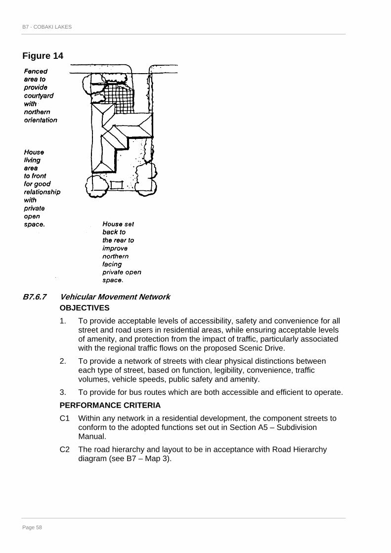
B7 - COBAKI LAKES
Page 58
Figure 14
B7.6.7 Vehicular Movement Network OBJECTIVES 1. To provide acceptable levels of accessibility, safety and convenience for all
street and road users in residential areas, while ensuring acceptable levels of amenity, and protection from the impact of traffic, particularly associated with the regional traffic flows on the proposed Scenic Drive.
2. To provide a network of streets with clear physical distinctions between each type of street, based on function, legibility, convenience, traffic volumes, vehicle speeds, public safety and amenity.
3. To provide for bus routes which are both accessible and efficient to operate. PERFORMANCE CRITERIA C1 Within any network in a residential development, the component streets to
conform to the adopted functions set out in Section A5 – Subdivision Manual.
C2 The road hierarchy and layout to be in acceptance with Road Hierarchy diagram (see B7 – Map 3).

B7 - COBAKI LAKES
Page 59
Figure 15
PERFORMANCE MEASURES M1 The design speeds and road widths shall be provided generally in
accordance with the guidelines for Street Characteristics (see Table 1). The final alignment of the routes being subject to the completion of engineering drawings to the satisfaction of Council's Director of Planning & Development in consultation with Council's Director of Engineering & Operations.
Figure 16
B7.6.8 Pedestrians and Cyclists OBJECTIVE 1. To provide a safe and convenient network for pedestrians and cyclists,
incorporating all weather paths and access to points of attraction within and adjoining the development.
PERFORMANCE CRITERIA C1 A network of pedestrian ways and cyclist ways to be based on:
- projected travel demand;

B7 - COBAKI LAKES
Page 60
- opportunity to link open space networks, community facilities and public services; and
- environment, location, safety and weather factors. C2 The network is to be provided in accordance with the Multi-Purpose Trail
diagram (see B7 – Map 8). PERFORMANCE MEASURES M1 Pedestrian/cyclist pathways shall be a minimum of 1.8m wide for secondary
paths and 2.6m for trunk paths. M2 Wherever possible pedestrian pathways will be a minimum of 1.2 metres
wide. Pedestrian/cyclist paths should follow open space corridors. M3 Paths shall use the most direct and environmentally acceptable route
between residential areas and community facilities, shopping centres, open space and schools etc.
M4 Pathways should wherever possible avoid grades which discourage use by cyclists and pedestrians. A maximum grade of 1:10 shall apply to all roads and paths except for bush trails which may have steeper grades.
M5 Cycle storage facilities shall be provided at shopping and community centres, schools and appropriate open space/recreation areas.
B7.6.9 Streetscape OBJECTIVE 1. To provide attractive streetscapes which reflect the precinct characteristics,
reinforce the functions of a street and enhance the amenity of development. PERFORMANCE CRITERIA C1 Development to provide an attractive streetscape setting with opportunities
for landscaping and varying setbacks. C2 Garages and carport locations to be arranged so that they do not dominate
the streetscape. C3 Landscaping to:
- complement the function of the street; - incorporate existing significant vegetation wherever possible; - be of an appropriate scale; - be sensitive to site attributes such as streetscape character, land
capability, microclimate, views and vistas. C4 Any building line setback from the street boundary, and any walls between
the building line and the street boundary to have minimal impact on existing or other future dwellings.
PERFORMANCE MEASURES M1 Submission of a Streetscape Plan including landscape detail to the
requirements of the responsible authority for integrated development.

B7 - COBAKI LAKES
Page 61
M2 To enhance the streetscape appearance front fences are not permitted in residential areas. Low set hedges, earth mounding and other soft landscaping elements are appropriate along street frontages.
M3 In selected areas wider than normal road reservations will be permitted to establish: - attractive and varied planting/landscaping (i.e. group, clustered or
grove planting as distinct from isolated stands of single trees in a row alongside the road);
- preservation of existing trees and tree screens (i.e. along Sandy Lane); - Accommodate and screen off-street parking.
B7.6.10 Vehicle Parking All development will provide parking in accordance with Section A4 – Advertising Signs Code. Shared carparking areas based on different use criteria i.e. shopping and restaurants will be considered.
B7.6.11 Utilities A servicing strategy for the whole site shall be prepared, consistent with contemporary civil engineering practice, and lodged with Council with civil engineering design plans for the next development stage approved by Council. All services and capacities are available to meet the needs of the development.
B7.6.12 Environmental Protection OBJECTIVES 1. To protect significant environmental areas in their natural state. 2. To facilitate active management and enhancement of areas of
environmental significance. 3. To limit disturbance of environmentally sensitive areas by controlling public
access, controlling edge impacts, changes in hydrological conditions particularly in respect of nutrients and sediment, and to incorporate appropriate buffers between development and such areas.
4. To facilitate the provision of faunal corridors and enhance the visual amenity of the area through existing and rehabilitated vegetation.
5. To identify areas of fauna habitat requiring further investigation and management to protect and enhance such habitat.
PERFORMANCE CRITERIA C1. Core areas of environmentally significant areas identified by Environmental
Protection (Habitat) 7(l) zoning are to be protected and managed through the preparation, approval and implementation of Plans of Management as outlined in Clause B7.3.6.
C2. Such Management Plans are to be prepared at the time of proposed subdivision or development of adjoining land or development within the core area, ie, within precincts 5, 6, 7, 8, 10, 12, or 14, and include provision for buffer areas as indicated below.
C3. Buffer areas are to be provided adjacent to such core areas and the adjoining Crown Land area to the east which is zoned Environmental

B7 - COBAKI LAKES
Page 62
(Wetland), including the areas affected by State Environmental Planning Policy No 14 - Coastal Wetlands (see B7 – Map 11).
C4. The purpose of such buffers is; to mitigate disturbance on the significant vegetated or habitat areas by slowing run-off, filtering nutrients and sediments; to allow for stabilising groundwater imbalance due to landfill, excavation or drainage works; to allow bushfire hazard management; and to control human and domestic animal intrusion and disturbance.
C5. The appropriate width of such buffers is generally to be a minimum of 20 metres in the case of the Shrub and Tree Heathland core area, and 10 metres minimum in the case of the remnant Wet Sclerophyll/Scrub Rainforest core areas at Mt. Woodgee and north-west of Turners Dip (Precincts 12 and 15).
C6. Within the buffer area on the north side of the Mt Woodgee core area, a refreshment room/observatory is an appropriate use with ancillary services and non-public road access integrated within the design and management of the Mt Woodgee Precinct, incorporating measures to mitigate disturbance and impact on the remnant forest (see B7 – Map 11).
C7. Other areas of specific environmental protection concern are as follows:
• Potential habitat for endangered or rare amphibians in fernlands immediately south-west of the shrub/tree heath community core area. In any proposal for development or disturbance of this area, a detailed assessment of its habitat value and measures to minimise impact as development proceeds is required.
• Potential habitat for arboreal mammals such as the sugar glider in eucalypt forest remnants on the plateau edge (Precincts 4, 5, 15).
• Known Greater Glider habitat area on plateau (Precinct 5). C8. Where development of the site in accordance with this Section and/or
consistent with the zonings of the site necessitates the loss of existing vegetation, Council may still consent to such development if it can be demonstrated that an effective reinstatement scheme for the locality (either on site or in adjacent areas) can be put into action.
B7.7 DEFINITIONS The following definitions have been adopted for the purpose of this Section. Access Place means a minor street providing local residential access with shared traffic, pedestrian and recreation use, but with pedestrian priority. Access Street means a street providing local residential access with shared traffic, pedestrian and recreation use with local traffic priority. Allotment means an area of topographical space shown on an approved plan of subdivision and on which it is intended to construct a dwelling or dwellings. Balcony means an open area, not being an enclosed room or area, attached to or integrated with and used for the exclusive enjoyment of the occupant or occupants of a dwelling.

B7 - COBAKI LAKES
Page 63
Bushfire Hazard Reduction means a reduction or modification (by burning, chemical, mechanical or manual means) of material that constitutes a bushfire hazard. Collector Street means a street providing for local residential access and local traffic movement. Cluster Development means the erection of more than one dwelling-house or duplex building on a single allotment of land within residential zones; Community Building means a building owned, occupied or operated by the Council or a public authority and used to provide facilities relating to any one or more of the following purposes: (a) art and craft centre; (b) child care centre; (c) health centre; (d) indoor recreation centre; (e) information centre; (f) kiosk; (g) library; (h) meeting room; (i) neighbourhood centre; (j) restrooms; (k) senior citizens centre; (l) youth centre; (m) welfare centre; (n) any other like purpose. Council means the Tweed Shire Council. Duplex means a residential flat building containing two but not more than two dwellings that are attached by a common wall, pergola, carport or the like, but such attachment cannot be in the form of a walkway, extended wall or other structure so designed to circumvent the requirement for the buildings to be suitably attached to each other. Earthworks means the addition or removal of any solid material on, to or from land, or any other work which will substantially alter the existing ground level or character of the surface of that land. Environmental Facility means a structure or work which provides for: (a) nature study or display facilities such as walking, board walks, observation
decks, bird hides or the like; or (b) environmental management and restoration facilities such as bush
restoration, swamp restoration, erosion and run-off prevention works, dunal restoration or the like;
Extractive Industry means: (a) the winning of extractive material; or

B7 - COBAKI LAKES
Page 64
(b) an industry or undertaking, not being a mine, which depends on the winning of extractive material from the land on which it is carried on, but does not include works for drainage and landfill.
Finished Ground Level, in relation to land, means: (a) where land is within an area designated by the council as flood liable land,
the adopted design flood level, adopted by the Council; or (b) where land is not within such an area, the level of the land (after
earthworks) as approved by the Council, or where no earthworks are proposed, the natural ground level of the land.
Floor Space means the sum of the area of each floor of a building, includes all wall thicknesses, ducts, vents, staircases, enclosed balconies and liftwells, but does not include: (a) any car parking space in the building provided to meet the standards
required by the consent authority (but not any space provided in excess of such standards) or any internal access thereto;
(b) space used for the loading or unloading of goods; and (c) lift towers, cooling towers, machinery and plant rooms and storage space
related thereto. Floor Space Ratio means the ratio of the area of the floor space of a building to the site area. Frontage of a Lot means that portion of a lot abutting a public road. Gross Floor Area means the sum of the areas of each floor of a building where the area of each floor is taken to be the area within the outer face of the external enclosing walls as measured at a height of 1400mm above each floor level excluding: (a) columns, fin walls, sun control devices and any elements, projections or
works outside the general lines of the outer face of the external wall; (b) lift towers, cooling towers, machinery and plant rooms and ancillary storage
space and vertical air conditioning ducts; (c) car parking needed to meet any requirements of the Council and any
internal access thereto; and (d) space for the loading and unloading of goods. Habitable Room means a room used for normal domestic activities; and
• includes a bedroom, living room, lounge room, music room, television room, kitchen, dining room, sewing room, study, playroom and sunroom, but;
• excludes a bathroom, laundry, water closet, food-storage pantry, walk-in wardrobe, corridor, hallway, lobby, photographic darkroom, clothes-drying room, and other spaces of a specialised nature occupied neither frequently nor for extended periods.
Height means the vertical distance between finished ground level and the finished level of the uppermost ceiling in the building, or where there is no ceiling the level at which the main roof beams meet the top plate.

B7 - COBAKI LAKES
Page 65
Heritage significance means historic, scientific, cultural, social, archaeological, architectural, natural or aesthetic significance. Home Office means an occupation carried on in a dwelling-house predominantly by the permanent residents of the dwelling-house which does not involve: (a) the registration of the building under the Factories, Shops and Industries Act, 1962; (b) the employment of more than one person other than those residents; (c) interference with the amenity of the neighbourhood by reason of the
emission of noise, vibration, smell, fumes, smoke, vapour, steam, soot, ash, dust, waste water, waste product, grit, oil, or otherwise;
(d) the display of goods, whether in a window or otherwise; (e) the exhibition of any notice, advertisement or sign (other than a notice or
sign exhibited on the dwelling-house to indicate the name and occupation of the resident); or
(f) a change in the appearance of the dwelling-house or land on which it is erected that is out of character with that of the surrounding area.
Integrated Housing Development means development for the purpose of: (a) the subdivision of land into five or more allotments; and (b) the erection of a single dwelling-house on each of the allotments created by
that subdivision. Landscape Area means that part of the site which is for the enhancement of the development and the enjoyment of the occupants. It excludes drying areas, garbage collection and handling spaces and any spaces used for the movement or parking of vehicles. Where Council deems it appropriate in terms of accessibility, treatment and appearance, the landscape area may include walkways, swimming pools, tennis courts, pergolas or other built elements at ground level. Lot - refer to Allotment. Objectives means statements of the desired outcomes to be achieved in the completed development. Performance Criteria means criteria to be used in the preparation, submission and assessment of development proposals for measuring performance of the proposals against objectives. Performance Measures are provisions which are accepted without any further evidence being required as one option for meeting the performance criteria. (Where any performance measure contains alternatives, the choice rests with the proponent). Private Open Space means an area of land suitable for private outdoor living activities. Public Open Space means land used or intended for use for recreational purposes by the public and includes parks, public gardens, riverside reserves, pedestrian and cyclist accessways, playgrounds and sports grounds.

B7 - COBAKI LAKES
Page 66
Primary Street Frontage means the boundary of an allotment having frontage to the highest class of road or, where intersecting roads are of the same road hierarchy, the road with the highest traffic generation (see subdivision manual). Residential Flat Building means a building containing two (2) or more dwellings and includes flat units, villa homes, town houses, terraces and the like. Secondary Street Frontage means the boundary of an allotment having frontage to the lowest class of road or, where intersecting roads are of the same road hierarchy, the road with the lowest traffic generation (see subdivision manual). Setback means the minimum required distance between the boundaries of a lot and the external wall of a building erected or proposed to be erected thereon. Site Area means the area contained within the title boundaries of the site or the area of land to which an application for consent relates, excluding any land upon which the development to which the application relates is not permitted under the Tweed Local Environmental Plan 1987. Site Cover means that portion of the site covered by the main building envelope defined by the external face of the perimeter walls. It shall also include balconies which do not have 2.6 metre clearance from finished ground level. Steady State means a state or condition of comparative balance within a fluctuating system determined by environmental and man influenced parameters. Streetscape Plan means a plan showing the visible components within a street (or part of a street) between facing buildings, including the form of buildings, setbacks, fencing, landscaping, driveway and street surfaces, utility services and street furniture such as lighting, signs, barriers and bus shelters. Storey means a floor within a building, including a floor used for storage or parking, but not including: (a) a roof, or part of a roof, used as an uncovered garden, terrace or deck; or (b) a floor no more than 1 metre above finished ground level used for parking. Tourist Accommodation means a building principally used for the accommodation of tourists but does not include a building elsewhere specifically defined in this clause. Tourist Facilities means an establishment principally used for the recreation or enjoyment of tourists and may include an amusement park, boat shed, boating facility, cruise craft dock, tavern, marina, playground, refreshment room, shop, theme park, water sport facilities or the like or a club used in conjunction with any such activities. Trunk Collector Street means a street connecting the internal street network serving residential development with the external, arterial road network. Verge means that part of the street reserve between the carriageway and the boundary of adjacent allotments (or other limit to street reserve). It may accommodate public utilities, footpaths, stormwater flows, street lighting poles and planting. Window includes a roof skylight, glass panel, glass brick, glass louvre, glazed sash, glazed door, translucent sheeting or other device which transmits natural light directly from outside a building to the room concerned.

Appendices/References/Bibliography
Page 67
REFERENCES 1. BIS Shrapnel Pty Ltd, Economic Assessment and Implications for the Tweed Shire.
April 1990. 2. Byron Shire Council, Byron Shire Development Control Plan No. 1, Byron Bay,
(undated). 3. Club Corporation of Australia Pty Ltd, Study of Regional Market Demand and
Competitive Factors (in relation to the golf operations and recreational facilities), February 1990.
4. D.B.I. Design Corporation, Cobaki Lakes - Preliminary Design Sketches 1991, QLD, 1991.
5. Department of Environment & Planning, Residential Development Standards - Technical Bulletin No. 15, NSW, 1982.
6. Department of Planning, House Designs for Small Lots, NSW, 1990. 7. Department of Planning, Victorian Code for Residential Development, VIC, 1991. 8. Golder Associates, Geotechnical Engineers, Acid Sulphate Soils Preliminary
Investigations, QLD, February 1991. 9. Ian Hill & Associates Pty Ltd, Report of Infrastructure to the Cobaki Community Project
Concept, April 1990. 10. Model Code Task Force of the Green Street Joint Venture - Australian Model Code for
Residential Development, 2nd Edition, Canberra, 1990. 11. Priest, Dr Denis, Summarative Appraisal of the Environmental Issues Pertinent to
Design Concepts and Management Strategies, March 1990. 12. State Pollution Control Commission, Environmental Design Guidelines for the Use of
Recycled Water in NSW, Sydney, 1990. 13. State Pollution Control Commission, Water Quality Goals and Objectives for NSW,
Sydney, 1990. 14. State Pollution Control Commission, Water Quality Criteria for NSW, Sydney, 1991. 15. State Pollution Control Commission, Pollution Control Manual for Urban Stormwater,
Sydney, 1989. 16. Tweed Shire Council, West Murwillumbah Draft Development Control Plan No 14,
NSW, 1990. 17. Tweed Shire Council, Consolidated Tweed Local Environmental Plan 1987, NSW,
1991. 18. Tweed Shire Council, Residential Development Strategy 1991,NSW 1990. 19. University of Queensland Archaeological Services Unit, An Archaeological
Assessment of a Proposed Development Site at Cobaki, South Tweed Heads, NSW., QLD, March 1990.
20. WBM Pty Ltd, Vegetation Field Study, February 1990. 21. WBM Oceanics Australia Pty Ltd, Groundwater/Water Quality - Data Collection Project,
April 1991. 22. WBM Oceanics Australia Pty Ltd, Wetlands and Aquatic Fauna, March 1990.

Appendices/References/Bibliography
Page 68
23. WBM Oceanics Australia, Evaluation of Terrestrial Fauna, March 1990.

THIS PAGE IS BLANK

Customer Service 1300 292 872 (02)66702400
Fax(02)6670 2429POBox816MurwillumbahNSW2484