Embed Size (px)
Citation preview

SECTION VI
FORMATION AND TRANSPORT OF ACID MINE DRAINAGE
Chemical Aspects of Acid Formation The sulfur-bearing minerals which predominate in coal seams are the iron sulfide ores pyrite, marcasite, amorphous 'sulfur-balls', and less commonly the monosulfide pyrrhotite. Excluding pyrrhotite, all have the same ratio of sulfur to iron but have different crystalline properties. The amorphous structure is reported to be the most reactive due to its large surface area, followed by pyrrhotite, marcasite, and pyrite. These crystalline structures are shown in Figure 6-1. The term FeS2 is used here to represent the crystalline pyritic agglomerates associated with coal strata, excluding the monosulfide (pyrrhotite (FeS)).
The exposing of pyrite materials to air and water leads to the following overall stoichiometric reactions which may characterize the oxidation of pyrite:
The oxidation of the sulfide (1) to sulfate releases dissolved ferrous iron and acidity into the water. After dissolution the ferrous iron undergoes oxidation to ferric iron (2) which then hydrolyzes to form "insoluble" ferric

hydroxide (3) releasing more acidity to the stream and coating the stream bed. Ferric iron can be reduced by pyrite itself, as seen in equation (4), where sulfide is again oxidized and acidity released along with additional ferrous iron which may reenter the reaction cycle via (2). The concentration of sulfate in the water may be directly correlated with the amount of pyrite which has been dissolved. The introduction of acidity into streams arises from the oxidation of S2 (-II) and subsequent hydrolysis of the resulting Fe (III). The dissolution of 1 mole of iron pyrite leads ultimately to the release of four equivalents of acidity, two equivalents from the oxidation of S2 (-II) and two from the oxidation of Fe (II). The decomposition of iron pyrite is among the most acidic of all weathering reactions because of the great insolubility of Fe (III). The scheme shown on Figure 6-2 has been proposed for the oxidation of iron pyrite in mine waters:
The rate determining step is reaction (b). The rate in mine waters is very slow with half-times on the order of 1,000 days of pH 3. However, half-times of 20-1,000 minutes have been observed for the oxidation of pyrite by Fe (III), reaction (c). To initiate the cycle, pyrite is oxidized directly by oxygen (a) or is dissolved and oxidized (a'). The ferrous iron formed is oxidized extremely slowly (b) and the resultant ferric iron is rapidly reduced by pyrite (c), releasing additional acidity and Fe (II) into the cycle via (b). Once the sequence has been started, oxygen is involved only indirectly in the reoxidation of Fe (II) (b); the oxidation of FeS2 is no longer significant.

Precipitated ferric hydroxide deposited in the mine, spoil or stream serves as a reservoir for soluble ferric iron, Fe (II) (d). If regeneration of Fe (III) by reaction (b) is halted so that the concentration of soluble Fe(III) decreases, it will be replenished by dissolution of solid Fe (OH)3 and will be free to act again if it comes in contact with additional FeS2. The preceding model suggests the following: (a) Ferric iron cannot exist in contact with pyritic agglomerates due to its very strong oxidizing and dissolving effect on sulfides as shown below:
(b) The exclusion of oxygen may not inhibit the regeneration of Fe (III).
(c) Implied in the model, microorganisms can influence the oxidation of ferrous iron by mediating the rate determining step reaction (b).
The Role of Bacteria in the Oxidation of Pyrites Several microorganisms have been isolated from acid mine drainage, the most important of which are the Thiobacillus ferro-oxidans and thio-oxidans. The organisms are a short rod and are usually separate, but sometimes are grouped in pairs. In natural acidic waters they are 0.8-1 microns long and 0.461 microns wide. The bacteria are ion-spore forming, gram negative that multiply by lateral division. The organisms are capable of oxidizing ferrous iron in an acid medium as well as sulfides. They are chemosynthetic autotrophs, deriving their carbon from dissolved C02 and certain salts, using energy obtained by oxidizing inorganic compounds. Until recently the formation of acid mine drainage was attributed to purely chemical oxidation of the iron sulfide, but with the isolation of the bacteria T. ferro-oxidans and T. thio-oxidans from mine water, the significance of bacterial action had to be considered. Early work by several authors (Temple and Delchamps, 1953; Leathen and Braley, 1953; Starkey and Waksman, 1943) suggested that stratal waters were neutral and that neither species was present. However, in the same areas after a few days of stripping, large numbers of both T. ferrooxidans and T. thio-oxidans were found with a concomitant increase of stratal water acidity. As further proof that bacteria play a definite role in the formation of acid, Leathen and Braley et al. separated sulfur-bearing ores from coal and inoculated these with the aforementioned organisms. Seven-day old cultures were used to inoculate solutions of crushed pyrite, marcasite, and 'sulfur-balls,' isolated from acidic mine waters. As compared to a sterile control, the bacterial dishes showed sharply increased acidity and sulfates as they acted upon the marcasite and 'sulfur-balls.' The concentration of sulfuric acid and sulfate increased five times, while the pH dropped from 3.6 to 1.2. The pyrite, however, was not oxidized.

Temple and Delchamps have advanced the following hypothesis on the formation of acid in coal mines:
(a) Pyrite or marcasite is altered to ferrous sulfate chemically
(b) The ferrous sulfate is then oxidized to ferric sulfate
Since the chemical oxidation of iron is extremely slow in an acidic medium, reaction (7) is due primarily to bacterial oxidation. As the ferric sulfate is formed, it reacts with any pyrite present, reducing the ferric sulfate and oxidizing the pyrite:
A portion of the ferric sulfate is hydrolized to the basic ferric sulfate or ferric hydroxide depending on the acidity, sulfates, ratio of ferrous to ferric oxide, and the water's buffering capacity:
Any molecular sulfur formed by reaction (8) usually does not react with the ferric sulfate, but is oxidized to sulfuric acid by T. thio-oxidans:

As seen from Figure, 6-3A two new, rapid pathways for oxidation and acid formation are produced. Investigations concerning the biological production of acid have been undertaken by several authors. Ashmeed (1955), from his experiments in two Scotland coal mines, determined that for each ton of sulfuric acid produced chemically, four tons were formed by bacterial oxidations. Thus, bacteria play an important role in the formation of acid in mines. See Figure 6-3A. Specific Geochemical Acid Formation In order to understand the specific acid formation problems of the area, it is instructive to review the geological structures present. The area occupied by the Foxburg and Clarion Quadrangle is a more or less dissected plateau region designated as the Appalachian Plateau. The structure of the plateau is simple, the strata lie nearly flat, and their regularity is broken only by small faults and low, broad folds. The northern end of the Appalachian Coal Basin extends through this region. The Allegheny formation is found throughout both quadrangles and forms the body of almost all of the hills. The outcrop of this formation occupies a far larger area than that of another in the region. The formation is composed of sandstone and shale interbedded with coal, clay, and limestone. Economically it is by far the most important formation outcropping in the area. The thickness of the Allegheny formation varies from 345 to 370 feet and extends from the base of the Brookville Clay to the top of the Upper Freeport Coal. Due to the considerable variation in the succession of strata, it is not possible to prepare a tabular section which applies to the entire area. Instead five individual acid-producing areas will be discussed below. (A) Anderson Run Area The major coal seams located immediately adjacent to Anderson Run are: i. Lower Kittanning (underlain by discontinuous vanport limestone on the left bank) ii. Upper Clarion iii. Lower Clarion iv. Brookville

The seams occur at or slightly below hilltop elevation and have been area stripped leaving large hilltop "flats" of extremely permeable overburden containing pyritic materials. The "flats" are reverse graded probably to prevent runoff, but create a new problem by forming recharge areas that allow precipitation to pass into the piles. As a result, oxygenated waters reach and react with pyrites producing sulfuric acid, soluble iron, and an ecological niche for iron-sulfur oxidizing bacteria which greatly increase oxidation rates. The acidic waters are free to cut solution channels through the spoil pile and emerge at a point where further percolation is impeded by a more or less impervious strata such as clay. The overall effect is observed to be extensive acid seep areas adjacent to the stream that destroys foliage and deteriorates water quality. A recent analysis of Anderson Run revealed the following characteristics: pH = 3.5 Sp. Cond. = 1550 Acidity = 330 mg/L Sulfate = 925 mg/L Hardness = 1,700 mg/L Most of the areas under consideration are similar to that of Anderson Run in that these have been area stripped, occur at high elevations, and have been graded to prevent runoff. (B) Mineral Run Area The major coal seams located adjacent to Mineral Run are:
i. Upper Clarion ii. Lower Clarion iii. Brookville
The coal seams are found at elevations of 1,200-1,300 feet in this area. It is also interesting to note that the Clarion or Brookville coals have considerable pyritic deposits associated with them and produce the worst seep areas. A recent analysis of Mineral Run revealed the following characteristics: pH = 3.7 Sp. cond. = 1,000 Acidity = 130 mg/L Sulfate = 400 mg/L Hardness = 1,400 mg/L


(C) Little Licking Creek The major coal seams located adjacent to Little Licking Creek are: i. Lower Kittanning, underlain by discontinuous vanport limestone ii. Upper Clarion iii. Lower Clarion The coal seams are found at elevations of 1,200-1,330 feet and have been extracted by area stripping. A recent analysis of Little Licking Creek revealed the following characteristics: pH = 4.5 Sp. Cond. = 1,600 Acidity = 166 mg/L Sulfates = 850 mg/L Hardness = 2,500 mg/L (D) Unnamed 112 Area The major coal seams in the unnamed tributary area are:
i. Lower Kittanning ii. Upper Clarion iii. iii. Lower Clarion
The seams occur at elevations of 1,230-1,330 feet. A recent analysis revealed the following characteristics: pH = 3.7 Sp. Cond. = 1,900 Acidity = 234 mg/L Sulfates = 1,075 mg/L Hardness = 1,100 mg/L (E) Licking Creek Area The major coals seams adjacent to Licking Creek are: i. Middle Kittanning ii. Lower Kittanning, underlain by vanport limestone at the headwaters iii. Upper Clarion iv. Lower Clarion v. Discontinuous Brookville

The seams are again located at hilltop elevation or slightly below and have been extracted by area stripping. A series of seep areas located in the vicinity of Sligo contributes acidity directly to the creek. A recent analysis of Licking Creek revealed the following characteristics: pH = 5.7 Sp. Cond. = 470 Acidity = 12 mg/l Sulfate = 175 mg/l Hardness = 2,323 mg/l The higher pH and low acidity indicate that natural alkalinity and stream flow dilution have improved the acid condition somewhat. Factors Controlling Mine Discharge Locations Meaningful recommendations to abate acid and iron pollution resulting from strip and deep mines in the Licking Creek Watershed can be made only when corrective actions are selected that are known to have corrective influences on water quality based on previous experiences or when considerations clearly indicate that quality improvements are inevitable. The decision to apply one or another corrective measure in the Licking Creek Watershed also should be tied to an understanding of the factors controlling groundwater movement both in deep and shallow flow systems because nearly all the mine discharges are diffuse, widely scattered and somewhat limited in volume rather than concentrated at a few major discharge points. A combination of topographical, soils, and geological factors accounts for the many and widely scattered discharges observed. Abatement procedures adopted are likely to have direct and rather immediate effects on the volume and concentration of some mine discharges. In other cases, months to years may be required to bring about noticeable water quality improvements. In still other cases, no improvements are likely to be brought about because the reclaimed area was not the cause of the particular mine discharge to be abated. For this reason, factors influencing the location of various discharges are discussed along with the methods that can be used to help define a particular watershed or subwatershed area that influences a particular discharge. Recognition of flow systems operating at various scales will be important in selecting abatement procedures, determining the origin of springs and seeps, and determining the response time of flow systems to abatement activities. Assumptions 1. Deep, immediate, and shallow groundwater flow systems are assumed to be present by analogy with other regions with a somewhat hydrogeologic setting. 2. The groundwater quality within all but the deep flow system has been adversely influenced by past mining activity and it is assumed this is true for the deep system as well.

3. No natural deposits comprising the stratigraphic sequence in the Licking Creek Watershed are considered impermeable. However, a range in permeability values is expected both in the horizontal and vertical direction for any given rock unit, and a considerable variation is expected among units because shale, sandstone, siltstone, underclay, coal, and limestone are all known to be present in the watershed. Shallow flow systems are those that operate relatively near the land surface and that convey groundwater to nearby discharge areas after but a few tens to thousands of feet of subsurface travel. These are commonly associated with spoil deposits. (See Figure 6-4.) Travel times within shallow flow systems should be measured in hours to a few weeks, and flow volumes and water quality should be highly variable and reflect recent precipitation and/or snow melt conditions. Some discharges may cease to flow entirely during dry months and in winter. These systems will respond swiftly to abatement procedures. Intermediate flow systems operate below strip mines and above and below some deep mines. Groundwater may travel for distances of hundreds to thousands of feet from points of recharge to discharge (Figure 6-4), and travel times will be measured in months to several years. Flow rates and water quality changes may be noted on a seasonal basis but rarely will respond to daily or weekly meteorological events. Months to several years will be required before water quality improvements will be noticed following the adoption of successful abatement measures. Deep flow systems involve groundwater movement into confined aquifers that may be tens to hundreds of square miles in area and located several hundred or more feet below ground. Distances of water movement may be measured in thousands of feet to miles from points of recharge to discharge, and interbasinal transfer of water is commonplace (Figure 6-4). Travel times are in years to tens of years or longer. Flow volumes and water quality changes should be essentially independent of day-by-day or even month-by-month meteorological events. Water quality changes will be slow in developing in response to either coal mining or abatement activities. Stratigraphic Sequence Some sidehill seepages are tied to shallow groundwater flow systems that are largely controlled by the stratigraphic sequence and the contrast of the permeability of individual units (Figure 6-5). Sandstone, siltstone and coal beds frequently are more permeable than shale and underclay (Brown and Parizek, 1971). Method of detection: Mine discharges controlled by sequence of beds can be detected by knowledge of the (1) stratigraphic sequence, and (2) to some extent by knowledge of the dip direction of bedrock units and the positions of "groundwater divides" on the potentiometric surface of confined aquifers. This data can be obtained from a study of geologic maps, field studies or a test boring program.

The Licking Creek Watershed has been mapped, but not in sufficient detail to show the outcrop location of individual map-able units except for coals. Correlations among selected bore holes have also been established, but control points are inadequate within the watershed to establish the presence and distribution of bedrock lithologies in detail. Bedrock dips are given in a general way on structural contour maps prepared during the 1930's. The contour intervals are adequate to give regional trends but do not show local structural features that can help channel groundwater to a particular discharge point. Small synclines, for example, can promote the discharge of groundwater to outcrop areas located near the fold axis, particularly in the plunge direction. The position of "groundwater divides" within confined aquifers can be approximated by a knowledge of the existing topographic configuration of an area, dip of beds, and permeability distribution within individual beds. Bedrock Structure Bedrock structure combined with permeability contrasts of spoil bank deposits account for a number of shallow discharges observed (Figure 6-6). These will be among the easiest to establish because spoil bank deposits have been placed on the sloping underclay which is still intact. The extremely high permeability of the spoil, low permeability of the underclay and slope of the underclay combine to favor lateral flow in the downdip direction (Figure 66). These discharges are likely to be more variable in quality and quantity of flow and should respond to changes in precipitation on a week-by-week basis. Groundwater within this setting is classed as occurring within a shallow flow system. Method of detection: Knowledge of the regional bedrock dip and former outcrop position on the mined-out coal will be helpful. Both types of data are available for mine maps. Spring and seepage lines should be located immediately below the spoil-bedrock contact provided that spoil has not been cast downslope extensively below the position of the original coal crop. Seepages and springs should be more numerous and have higher flow volumes located on hillslopes in the downdip direction. Discharges on the updip valley wall should be minor to nonexistent.


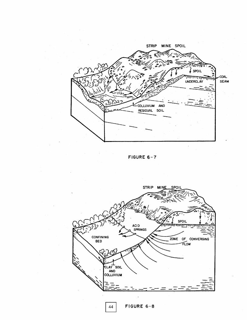
Spoil Cast Discharges Figure 6-7 shows a rather common condition observed in the Licking Creek Watershed. Overburden spoil deposits have been cast downslope below the original coal. outcrop location. The high permeability of the soil, slope of the original land surface, and low permeability of the underlying soil and bedrock combine to favor seepages in this setting. Flow volumes will be minor if the cast-over deposits are limited in areal extent and the underclay slopes in the opposite direction as shown in Figure 6-7. Commonly, however, the dip and castover direction are the same and flows are compounded from the two sources. Method of detection: Frequently castover deposits vary in elevation in a highly irregular manner and occur at elevations lower than the original coal bed that was mined. This condition can be established by field inspection to some extent and by comparing recent topographic maps with coal outcrop maps or structural contour maps. Spring Lines above Colluvium and Alluvium Figure 6-8 shows a hydrogeologic setting in western Pennsylvania that accounts for the sidehill position of springs and seeps. Colluvium, stream alluvium, and residual soils often contain sufficient clay to make them relatively low in permeability. These deposits characteristically blanket low portions of slopes and valley bottoms and serve as confining beds to underlying "aquifers." Aquifers may be relatively productive siltstone and sandstone beds or the fractured, mechanically weathered top of bedrock that may even include shale and underclay. The configurations of intermediate flow systems are influenced by this confining layer which promotes the concentrated discharge of groundwater where these deposits thin out along valley walls. The spring and seep line may be located just above the contact between flood plain sediments and the valley wall, or high above the flood plain where alluvium forms tributary valleys and colluvium is well developed. Method of detection: Maps showing soil series and individual mapping units within series can be used when available to classify these spring lines. Also, a geomorphic analysis can be made using areal photographs and field observations to map the contact of alluvial fans, flood plain and colluvial deposits. Colluvial and alluvial contrast springs are numerous in the Licking Creek Watershed, and frequently springs will be controlled by this and a combination of one or more other factors.