Embed Size (px)
Citation preview
VIII-1
SECTION VIII. HISTORIC RESOURCES
A. INTRODUCTION The inclusion of this Historic Resources Section in the Master Plan is the first time that the Concord Master Plan has included such a section. Goals for the preservation of historic resources are set forth. An overview is provided of the City’s history as well as the history of the neighborhoods within the City. A description of available tools and techniques for historic preservation is presented followed by a review of the City’s historic preservation activities. Policies and recommendations are presented for future actions related to the preservation of the City’s historic resources.
B. GOALS RELATED TO HISTORIC RESOURCES The overall goal is to recognize, preserve, enhance, and continue the use of buildings, structures, sites, areas, and districts having historical, architectural, or cultural significance to the City. The specific historic resource goals are to: 1. Safeguard the heritage of Concord by providing for the protection of structures and areas
representing significant elements of the City’s cultural, social, economic, political, and architectural history.
2. Encourage the rehabilitation of historic buildings that reflects and respects each building’s
historic character. 3. Encourage development that reflects and respects the historic landscape. 4. Encourage adaptive reuse that respects character-defining features of historic buildings and
structures. 5. Promote the identification of, consideration of impacts to, and mitigation measures (such as
avoidance) for historical properties affected by development. 6. Remove any unintended impediments to the rehabilitation and/or reuse of historic properties
inherent in the City’s land use regulations and building codes. 7. Complete a comprehensive survey of historical resources for the entire city. 8. Encourage the preservation of historic barns and other significant agricultural outbuildings. 9. Identify and designate scenic roads in outlying rural areas. 10. Encourage the protection of historic stonework including stone walls, foundations, and
culverts. 11. Revise the City’s design review guidelines to include an historical resources component.
VIII- 2
12. Amend the City’s development regulations to include provisions for review and comment by the Heritage Commission on development proposals that potentially impact historical resources or an historic area.
13. Provide for consultation with the Heritage Commission when a City-owned historic property
is impacted by proposed alterations, new use, or disposition. 14. Develop a process for review and comment by the Heritage Commission relative to
architectural changes proposed for historic properties owned by the school districts and the State within Concord.
15. Promote use of the federal tax credits in local historic rehabilitation projects. 16. Develop priorities for the future listing of properties on the National Register. 17. Promote the concept of Neighborhood Heritage Districts, founded on neighborhood-based
sponsorship and support.
C. CONCORD’S HISTORICAL AND ARCHITECTURAL DEVELOPMENT 1. Citywide Historical Overview Located in the geographic center of New Hampshire, Concord is bounded on the north by Webster, Boscawen and Canterbury; on the east by Loudon and Chichester; on the south by Pembroke and Bow; and on the west by Hopkinton. The fertile floodplains along the Merrimack River provided the impetus for early settlement in this area. The Concord area is part of the land occupied by the Western Abenaki peoples prior to European contact. Population estimates for this region, essentially all of what is now Vermont and New Hampshire range from 5,000 to 10,000 people at the beginning of the 17th century. People in this region tended to move from large towns to small camps at various times of the year. The area around Concord itself was the land of the Penacook, and evidence of 16th and 17th century European contact has been found along the Merrimack south of Concord and to the northeast around Ossipee Lake and Lake Winnipesauke. During the first decades of the 18th century, the general area was ravaged by warfare as a result of struggles between France and England and efforts at native extirpation by the New England colonists (New English). a. 1726-1808 - Concord was founded by Europeans around 1720, when Captain Ebenezer Eastman arrived from Haverhill with a group of settlers. The initial plantation of “Pennycook” was formed by a grant in 1725. The plan of Concord was unusual in that it was laid out as a nuclear town (commonly used in Massachusetts) rather than as a range township (the plan most commonly used in early New Hampshire settlements). This meant that most of the lots and later homes were located in the central village, primarily along Main Street. In 1727, the area east of the river and in what is now West Concord was laid out and by late 1731 over 85 houses had been at least partially erected in the town. In 1733, the plantation was incorporated as the town of Rumford. In 1744, Rumford was fortified with ten blockhouses during the first French War (also known as King George’s war, 1744-1748) Following the Revolutionary War, Concord benefited from its position as the terminus of both the First and Fourth Turnpikes. Residential and mercantile activity remained clustered at the north

VIII- 3
end of Main Street although the villages of West and East Concord continued to evolve throughout this period. b. 1808-1842 - Concord was designated as New Hampshire’s state capital in 1808, dramatically impacting the city’s commercial, professional and industrial development. The first State Prison was built in 1812, followed by the NH State House in 1819. In 1823, Concord became the county seat or shire town for Merrimack County. The business district, concentrated on the north end of Main Street, began to branch off into other areas. Many of the City’s existing streets were in place by 1834, with the village core extending from Main Street on the east to Penacook on the north, Merrimack Street on the west and West, Water and Hall Streets on the south. Houses and businesses lined Main, State, South and Green Streets. Diverse manufacturing and extraction industries supplanted agriculture as the dominant economy of Concord during this period – granite quarrying, furniture making, musical instrument building, and the manufacture of freight vehicles by the Abbot-Downing Company (founded 1813) were the most prominent. The villages surrounding Concord’s center continued to expand slowly, but residential growth remained concentrated in the Central Village. c. 1842-1914 - The arrival of the railroad in 1842 had a profound impact on Concord and ushered in the City’s period of greatest change. After the eventual consolidation of over 30 separate railroad lines, the Boston & Maine (B & M) Railroad emerged as the primary company in New Hampshire. The City’s population doubled in the decade following the railroad’s arrival, reaching approximately 9,000 in 1853. It was in that year that Concord became incorporated as a City. The granite industry expanded significantly in the post-Civil War period and Concord granite became highly sought-after throughout the country. The success of the Abbot-Downing coachworks spawned numerous ancillary industries such as harness and axle makers. Printers, belt makers, iron foundries and silver makers all prospered and expanded during this time period, benefiting from a highly skilled workforce. At the close of this period the railroad was the City’s largest employer. The New Hampshire State Hospital opened in 1842 and a new prison facility was opened in 1880. A civic district emerged around the newly renovated State House during the 1880’s that eventually included the Post Office, Courthouse, State Library and City Hall. The City initiated a period of major civic construction in the final quarter of the 19th century with the construction of police and fire stations and a library that was built by Daniel Chester French (the current library was erected in the 1930s). Sewerage and water works systems were built and numerous public schools were constructed. Residential development exploded during this period and by the first decade of the twentieth century many of Concord’s downtown neighborhoods were fully developed. Most of the homes were single-family, wood-frame houses, although a large number of duplexes including the distinctive “Concord Duplex” and a number of brick homes are found throughout the city. Starting in 1878, streetcar lines from South Main Street to Penacook brought residents to and from work and shops and allowed for even more substantial growth in the West End, West Concord and Penacook. During this era, the village of Penacook (initially called Fisherville) became known as a center of textile and furniture manufacturing, while East and West Concord continued to grow at a steadier pace with West Concord benefiting from country’s reliance on Concord granite. A strong rural tradition of farming continued in the areas immediately surrounding the City’s urban area. d. 1914-1944 - In the years after World War I, following a pattern seen throughout New England, the influence of the railroad and industries of Concord began to wane. Electronics, printing and insurance replaced the railroad as the leading employers during this period. The

VIII- 4
rise of the automobile brought about changes in the character of the city as major arteries were widened and forced out the street car lines. Relatively little construction took place during this period. Residential growth continued at a slower pace and was concentrated in the South End and apart from the Concord Public Library and the State House Annex, few governmental structures were built during this time. e. 1945-2006 - The use of passenger rail continued to decline after World War II and came to an end in the 1960s. The Concord rail station was replaced by a shopping center in 1960-1961, but Concord remained major transportation center with the construction of Interstate Highway System through Concord including first I-93, then I-89, and culminating with the construction of I-393. The railroad and textile industries, and most of the granite and printing concerns closed shop by the middle of the twentieth century. In 1954 the Concord Regional Development Corporation (CRDC) was formed to attract new industry in response to the decline of the long standing industrial concerns. CRDC was able to attract new industries and business to outlying industrial parks on the Heights near the Airport and in East Concord at I-93 Exit 16 and in Penacook at I-93 Exit 17. During this period Concord’s largest employer became the State of New Hampshire, while Concord grew to be the second largest Health Care Center in NH, and a major retail, wholesale, finance and professional service center. Residential development continued after World War II with major subdivisions on the Heights, in the Fisherville Road corridor between West Concord and Penacook, in the South End, and in East Concord. Concord went through several major growth periods, including one in the early 1970’s and another in the mid-1980’s. Many new subdivisions and multi-family complexes were constructed and available land has become more scarce within the last two decades. 2. Village/Neighborhood Historical Overview Reflecting initial settlement patterns, Concord has developed into distinct areas of individual character. These areas have been previously identified and characterized (Hengen, 1988 and Hengen, 1994). It is important to note that due to a history of a highly diversified industrial base coupled with the relative stability of large numbers of state government employees, Concord has an extremely well-preserved housing stock dating from the mid-nineteenth century to the present, leaving a legacy of neighborhoods with little modern infill. Despite some diffusion of the city center with the construction of outlying shopping malls and office complexes, the city center remains vital and its historic character remains substantially intact. This is largely due to the adaptive reuse of the City’s historic buildings. The architectural integrity of the building stock of the City of Concord has been remarkably maintained. Literally hundreds of properties retain sufficient integrity of location, design, setting, materials, workmanship, feeling and association to merit inclusion on the National Register either as contributing structures in historic districts or as individually eligible properties. The large size of Concord geographically has allowed for the creation of a varied collection of neighborhoods, villages and rural areas. a. Penacook - The Village of Penacook, located at the northern edge of Concord within Concord and Boscawen, was first settled in the 1750. The economy of this village was developed on agriculture, forestry, and small-scale manufacturing, first in the form of gristmills, and later in the 1830s and 1840s, in the production of cotton cloth. One key resource which dates from this time period is Penacook Mill, a 90,000 square foot stone mill built in 1846. The village prospered during the second half of the 1800s as other small factories began to produce wagon axles, matches, tanned leather, and electrical instruments. The housing stock of the village is divided between the vernacular-style houses built for the factory workers and the larger and more architecturally sophisticated homes of the mill owners and merchants. Elm,
VIII- 5
Washington, and Bonney (formerly Pleasant) Streets are all lined with predominantly post-Civil War era homes built in the Second Empire, Queen Anne, Gothic Revival and Italianate styles while the majority of the worker housing, consisting mainly of Greek Revival-style and Italianate side-hall and duplex houses, is concentrated along Merrimack, Summer, High, Shaw (formerly Spring), and Coral (formerly Union) Streets. The character of Penacook remains substantially intact as a mid-late 19th century industrial village, despite some demolition and unsympathetic infill within the central business district along Village Street (formerly Main Street). b. East Concord - The village of East Concord, located on the east side of the Merrimack River and north of I-393 was not established until the late 18th century, although some houses built by the relatives of the first settler Captain Ebenezer Eastman in the mid-1700s remain along Portsmouth, Eastman and Shawmut Streets and Mountain Road. Typically, the basis of the economy was the small manufacturing operations located primarily along Mill Brook, and the housing stock of the village reflects the dichotomy of the simple housing built for workers and the more elegant homes built for merchants and prosperous farmers. Perhaps most significant to the village are the existing upland farms located along Mountain Road and the rural quality of the existing farmsteads and summer camps located along Graham, Snow Pond, and Hot Hole Pond Roads. The village of East Concord remains intact despite the obvious changes brought about by the construction of I-93. The diversity of housing styles found throughout the village is impressive. Georgian, Greek Revival, Italianate and Gothic Revival style buildings are found along Eastman Street and Mountain Road. c. West Concord - West Concord village is located north of the city center on the West side of the Merrimack River. West Parish, as it was originally known, remained primarily a farming community until the granite quarries began their operations in the 1810s. The peak period of the granite industry was ushered in by the construction of the railroads and lasted between 1865 and 1929. The demand for worker housing (single family and duplex houses) in the area resulted in the development of Fosterville. West Concord Village contains perhaps the most intact pre-Civil War village center in the City. There are a large number of pre-1840 houses, most of which are scattered along North State, Hutchins, and Lake Streets. Many of pre-1840 houses still exist in this village and the village is still surrounded by open space and farmland. North State Street also contains a large number of important 18th and 19th century houses. The State Prison has been a prominent presence in the village since it was moved here in the 1880s. Its vast masonry complex is comprised of numerous outbuildings and an associated farm. d. North End - The North End was the original settlement area of Concord, with most of the City’s first houses built along the northern portion of Main Street. Development continued in the area throughout the eighteenth and nineteenth centuries, despite the fact that the first State Prison was located here in 1812. The North End became the commercial heart of Concord and remained so until the mid-19th century. The land for White Park was donated to the City in 1884, the park was designed in 1888, and it remains an important example of naturalistic landscape architecture. Stylish residences were built on the main arteries of the North End throughout the nineteenth and early twentieth centuries. However, the majority of the building stock consisted of housing for workers employed in the various local industries such as the nearby Ford Iron Foundry, Durgin Silver Factory, and Page Belting. Industrial sites and clusters of residential development characterized the North End until the 1930s, when commercial development began to replace blocks of older homes on North Main Street and the industrial uses were substituted for by office and educational institutions. The character of the North End neighborhoods depends largely on the architectural integrity of the area’s remaining residential properties.
VIII- 6
e. South End (including Abbott-Downing and Broadway-Rollins Park Neighborhoods) - This area of Concord was mostly developed between 1880 and 1920, much later than most of the other villages. This area has been surveyed extensively over the years and has been described in NH Division of Historical Resource (DHR) area forms for the Broadway Rollins Park Area, Concord Districts A&B, the Upper South End, and the Abbott Downing Neighborhood, each area of which has now been recognized as a separate National Register-eligible Historic District. The largely intact houses located along West Street serve as a veritable timeline of the City’s housing types – from farmhouse to Bungalow. Duplexes and tenements for the village’s carriage workers and are concentrated along Downing, Perley, Laurel, Pierce, and Grove Streets. Dunklee Street and the neighboring side streets feature a variety of Colonial Revival, Craftsman, Tudor Revival, and Queen Anne pattern-book homes. Clusters of Bungalow cottages and other modest turn of the century era housing styles are found on the streets surrounding Rollins Park. There is relatively little commercial intrusion in these neighborhoods and the condition of the housing stock is exceptional. f. Lower West End - Also know as the Centre Street/Pleasant Street Historic District, this area west of the Statehouse and downtown, began to develop as a cohesive residential area in the 1830s. By the late1850’s, this neighborhood was fully developed with dense residential development westerly from downtown to Merrimack Street and was develop along Warren Street as far as West Washington Street. This area has experienced relatively few modern residential incursions, leaving a remarkably intact mid-19h century neighborhood with relatively uniform sized lots and building massing. Stylistically the area seems to run the gamut of building modes of that era from late federal to Greek Revival to Italianate with some colonial revival and Queen Anne style buildings as well. g. Upper West End - The area west of Liberty Street grew rapidly after the streetcar came up Centre Street in the late 1880’s. In 1890 a group of prominent professionals laid out the first subdivision and over the next two decades, large comfortable houses were built on relatively large lots on School and Auburn Streets, as well as on lower Ridge Road and the streets west of White Park. There is a cohesive visual nature to this area created by the relatively uniform size of the buildings and their lots as well as a predominant use of Colonial Revival decorative forms. h. Concord Heights - Due to the sandy soil, thick growth of pine groves and the bluffs located along the riverbanks, the Heights remained lightly settled until after 1900. Prior to that time, the New Hampshire Turnpike terminated in East Concord. A residential nucleus began to emerge during the 1920s and 1930s as Loudon Road and Manchester Street developed, displacing the few farmsteads in the area. These two thoroughfares became service roads that were dotted with gas stations and tourist cabins to accommodate the growing trend of automobile tourism. The flat plateau became the perfect location for the City’s airport. In the period following World War II, the Manchester Street area developed around the auto service and sales industries. The Loudon Road corridor was filled with high density residential developments and became the home of most of the City’s large scale retail development. i. Outlying Rural Areas - Numerous farmhouses, mill sites and well-preserved 18th and 19th century properties are found in the City’s surrounding rural areas, including:
• Horse Hill - There are only a few historic structures located in this area comprising the northwest corner of the City. These are primarily found along Runnells Road, Elm Street, and River Road. The Contoocook River Park just west of Penacook was developed by the Concord Street Railway in the 1890s. While the City has acquired much of the original
VIII- 7
parkland, nothing remains of the park structures, but numerous early 20th century cottages line the banks of the river to the west of the park.
• District Five /West Parish Road - This section of Concord located in the west central portion of Concord is one of the most intact rural areas in the city with the largest number of late 18th and early 19th century properties and fewest number of newly constructed buildings in the City. Large orchards and farms still exist throughout this area and add tremendously to the overall rural character of the place. Penacook Lake, once known as Long Pond, was a popular recreational facility during the 19th century.
• Millville-Hopkinton Road - During the 18th and 19th centuries, the area of Hopkinton Road between Fiske and Long Pond Roads was a busy industrial community of sawmills, gristmills, a blacksmith shop, a carriage shop and two schoolhouses. East of this area, along Pleasant Street, large institutional buildings are commingled with 19th century farmsteads and early 20th century residential infill. St. Paul’s School, with buildings and grounds designed by major architects of the 19th and 20th centuries, now dominates Millville in the area between Hopkinton Road and Dunbarton Road. West of St. Paul’s School, 18th and 19th-century farmsteads lead up to Dimond Hill Farm at the City limits.
• Stickney Hill - Located at the western edge of the town and virtually inaccessible from Concord proper, Stickney Hill Road is among the best-preserved 19th century rural landscapes in the City. This road provides access to farmsteads and open fields that overlook the Turkey Ponds, with stonewalls and mature trees.
• Silk Farm Road - Named for an abortive 19th-century attempt to cultivate silkworms, the area contains two mid-18th century farmhouses. Operating farms are still located along the southern end of the road, parts of which have been realigned to accommodate I-89. The southern end of the road has been subject to development with modern subdivisions and cul-de-sacs.
D. DESCRIPTION OF PRESERVATION PLANNING TOOLS 1. National Register of Historic Places The National Register of Historic Places is the nation's official list of historical resources worthy of preservation. Authorized under the National Historic Preservation Act of 1966, the Register is part of a national program to coordinate and support public and private efforts to identify, evaluate, and protect historic and archeological resources. Resources can be buildings, districts, sites, landscapes, structures or objects that are significant in American history, architecture, archeology, engineering, or culture. Properties can be listed in the Register either individually or as part of an historic district. If a property is part of a district, it will be designated either a contributing or a non-contributing resource. Each contributing resource has all the same benefits of listing as individually listed properties. Benefits of listing on the National Register, whether individually or as part of an historic district, are as follows:
• Recognition that a property is of significance to the nation, the state, or the community • Some protection from impacts caused by state or federally funded, licensed or assisted
projects

VIII- 8
• Eligibility for federal tax benefits if undertaking an approved rehabilitation project and the property is income-generating
• Qualification for federal assistance for historic preservation, when funds are available • Special consideration or relief in application of access, building and safety codes • Strong marketing tool for owners and businesses • Leverage for the community when working with developers, in that listing publicly
recognizes a significant community asset. • Promotion of the unique features of buildings helps owners make sound decisions on
rehabilitation and maintenance issues • No restrictions on using or altering the property, as long as only private funds are
involved A National Register historic district is group of related properties that, instead of being listed individually, are listed as a grouping. Contrary to popular belief, there is no regulatory oversight of National Register districts: owners are free to make alterations of any type without seeking approval. 2. State Register of Historic Places New Hampshire’s State Register of Historic Places recognizes and encourages the identification and protection of historical, architectural, archeological and cultural resources. Resources may be buildings, districts, sites, landscapes, structures or objects that are meaningful in the history, architecture, archeology, engineering or traditions of New Hampshire residents and their communities. A resource must meet at least one of the following four criteria for listing: 1. Tell a story about an event(s) that is meaningful to a community’s history 2. Have an association with a person(s) who made important contributions to a community,
professional or local tradition 3. Represent a local architectural or engineering tradition; exemplify an architectural style or
building type; or serve as a long-standing focal point in a neighborhood or community 4. An identified, but unexcavated and unevaluated archeological site that is likely to yield
significant information about the lives, traditions and activities of former residents Generally, an eligible resource must be at least fifty years old. It must also retain enough of its historic character and physical attributes to illustrate what it is being nominated for. Properties that are listed on the State Register:
• Are publicly recognized for their significance to a community • Are considered in the planning phase of local or state-funded or assisted projects • Qualify for state financial assistance for preservation projects, when such funds are
available • Receive special consideration or relief in application of access, building and safety
codes • Are not restricted as to use or alteration as long as only private funds are involved
3. Locally Designated Historic District
A locally designated historic district is one of the most effective and comprehensive mechanisms to manage change in a historic area. Its purpose is to preserve the significant character of an area, while accommodating and managing change and new construction in accordance with regulations developed by local consensus.

VIII- 9
A locally designated historic district is a zoning (usually overlay) district. They are established in Concord by the adoption of a Historic (HI) Overlay Zoning District by the City Council and administered by the Heritage Commission. The Commission reviews and approves exterior alterations, new construction and demolition within the district, using officially adopted regulations and guidelines. 4. Neighborhood Heritage District A neighborhood heritage district (also known as a neighborhood conservation district) is similar to a locally designated historic district, but the neighborhood heritage district would operate under more flexible, less stringent standards. While a new concept for New Hampshire, a Neighborhood Heritage District could be established and operate under the same enabling statues as would a Historic District. A heritage district is a group of buildings and their settings that are architecturally and/or historically distinctive and worthy of protection based on their contribution to the architectural, cultural, political, economic or social history of the community. Sometimes a heritage district lacks sufficient significance or integrity to be designated as a traditional historic district. Other times, the neighborhood or political climate favors looser standards. Within a neighborhood heritage district, some degree of change is subject to mandatory review and approval. In most instances, the change is defined as major alterations, additions, new construction, demolition or relocation. Some communities have binding review over major changes and advisory review over minor changes, such as window replacement, applying synthetic siding, removing architectural trim and demolition of a part of a building, such as a porch. Overall, heritage districts seek to limit the detrimental effect of alterations, additions, demolitions and new construction on the character of the community through a combination of binding and non-binding regulatory review. 5. Community Revitalization Tax Relief Incentive (Downtown Tax Incentive) Newly passed by the legislature, the Community Revitalization Tax Relief Incentive RSA 79-E encourages investment in downtowns and village centers by temporarily granting property tax relief in exchange for properties that have been substantially rehabilitated and on which the owner has granted an covenant that insures a continued public benefit that extends for the life of the abatement or twice the length of the abatement as determined by the legislative body. Qualifying properties must be located downtown and undergo a rehabilitation costing at least 15% of the building's pre-rehab assessed value, or $75,000, whichever is less. The rehabilitation must be consistent with the municipality's master plan or development regulations. The rehabilitation must provided one of the following public benefits as defined in the statute; an enhancement of the economic vitality of the downtown, the enhancement or improvement of a structure that is culturally or historically important, it promotes the development of a municipal center, or it increases residential housing in an urban or town center. The City must adopt the provisions of this program before a property owner may apply for tax relief. 6. Preservation Easements A preservation easement, comparable to a land conservation easement, is a voluntary legal agreement that protects a significant historic, archaeological, or cultural resource in perpetuity. It provides assurance to the owner of an historic or cultural property that the property’s intrinsic values will be preserved by subsequent owners. An easement grants partial interest in a property, through sale or donation, to a grantee, which can be a qualifying local governing board, such as the City of Concord, or non-profit historical organization, such as the New
VIII- 10
Hampshire Preservation Alliance. With a preservation easement, the owner gives that second party the right to protect and preserve the historic and architectural features of the property. The property remains in private ownership, and the community continues to receive annual tax revenue. If the property is listed on the National Register of Historic Places, the value of the donated easement is federally tax deductible as a charitable contribution. 7. Barn Easements Under state law passed in 2002 (RSA 79-D), municipalities can grant property tax relief to barn owners who can demonstrate the public benefit of preserving their barns or other old farm buildings and agree to maintain their structures for a minimum of ten years by means of a preservation easement. The statute defines agricultural structures to include barns, silos, corn cribs, ice houses and other outbuildings, as well as the land on which they sit. The structure must currently or formerly have been used for agricultural purposes and be at least seventy-five years old. At last count, nearly 200 New Hampshire barns and other agricultural buildings in forty-eight towns had been protected in this manner. The law is based on widespread recognition that many of New Hampshire’s old barns and agricultural outbuildings are important local scenic landmarks and help tell the story of agriculture in the state’s history. Yet many of these historic structures are being demolished or not maintained because of the adverse impact of property taxes. The law is intended to encourage barn owners to maintain and repair their buildings by granting them specific tax relief and assuring them that assessments will not be increased as a result of new repair and maintenance work. It is strictly voluntary on the part of the property owner, and it combines established criteria and guidelines at the state level with decision-making and implementation at the local level.
E. SUMMARY OF HISTORIC PRESERVATION ACTIVITY TO DATE 1. An Established Tradition of Historic Preservation Organized public preservation activity in Concord began in the 1960’s when the pending demolition of the Franklin Pierce House and the former U.S. Post Office (now the Legislative Office Building) brought the community together in successful protests. The Concord Historic District and the administering Historic District Commission were established in 1967 “to safeguard the heritage of the city as it is represented in structures of historical and architectural value located, or which may be located, in the Historical District.” The District was listed on the National Register of Historic Places in 1975 and since that time, the Concord Civic District, Downtown Concord and twenty-four individual properties have also been listed. Concord was among the first cities in New Hampshire to apply to the National Park Service’s Certified Local Government Program in 1989. This allowed the City to receive federal funds and technical assistance to integrate the process of historic preservation with the work of the local government. In 1994, Concord became the first city – and one of the first communities – in the state to establish a Heritage Commission. The Heritage Commission replaced the Historic District Commission, assuming its regulatory duties in addition to providing advice on preservation-related projects throughout the city. In 2001 the Heritage Commission successfully spearheaded the adoption of a demolition review ordinance, the first such ordinance in New Hampshire to cover the entire city. Since its enactment, it has reviewed more than two dozen proposed demolitions and successfully found
VIII- 11
alternatives to demolition for every application that involved a significant historical resource. One such proposed demolition, the Rolfe Barn in Penacook, thrust the Commission into the national spotlight, as it worked alongside the Penacook Historical Society to prevent the loss of this remarkable structure. The Commission regularly provides advice to the City Council, other boards and commissions, and the public on matters relating to historical resources. Its proposal for the Sewalls Falls Bridge – rehabilitating the original structure for one-way traffic and building a simple, modern structure adjacent to it – received the endorsement of the Council. The Commission also works closely with the City Council and the City’s Director of Real Estate Assessment to review and make recommendations on applications for barn preservation easements. In addition to the work of the Heritage Commission, the City’s Architectural Design Review Committee frequently reviews applications affecting historical resources, providing advisory recommendations to the Planning Board. In the past couple of decades, many private businesses, sometimes in a public-private partnership, as well as individuals have undertaken major rehabilitation projects that have preserved and retained the viability of historical buildings throughout the city. Main Street Concord established through the auspices of the NH Main Street Program, an arm of the National Trust for Historic Preservation, has brought another level of interest and momentum to preserving the distinctive buildings and streetscape of downtown Concord. The Chamber of Commerce and Heritage Concord, Inc. (now dormant) provided walking tours of the city in the 1980s and 1990s; the former published an historic downtown walking tour brochure and the latter reprinted the 1876 bird’s-eye view of Concord, both of which remain in print. In 1995, the Penacook Historical Society was formed to foster appreciation for the history of the village and vicinity of Penacook. In the wake of Concord’s Sesquicentennial in 2003, a Concord Historical Society was established to promote public awareness, understanding and appreciation for Concord’s history and traditions. Its current and primary project is to write and publish a history of Concord in the twentieth century. In the late 1990’s, the Museum of New Hampshire History opened its new museum at Eagle Square in the Historic Stone Warehouse with the assistance of ISTEA funds and NH State Tax Credits. The State’s Land and Community Heritage Investment Program has funded the protection of two significant cultural landscapes: Carter Hill Orchard (formerly Sunnycrest Orchard) and Rossview Farm, both in West Concord. The program also funded structural repairs and conservation work for the highly important interior of the Benjamin Kimball House adjacent to the Capitol Center for the Arts. In 2006, with the protection of Dimond Hill Farm on Hopkinton Road, the City celebrated its first combined conservation and preservation easement – one of the first such easements in a new trend in New Hampshire to protect historical/cultural landscapes. 2. Architectural Surveys An overview historic/architectural survey, also known as a “Townwide Area Form”, was completed in 1996 under the auspices of the Heritage Commission. It included an overview
VIII- 12
history of Concord from an integrated historical, architectural and developmental perspective. Within each chronological period, an analysis of representative surviving historical resources was presented. The survey also identified all of the City’s existing and potential historic neighborhoods and areas. Three more detailed architectural/historical resource surveys of specific areas have been conducted:
• Downtown neighborhoods (1988) • Penacook Village (1990) • Downtown Concord (1999)
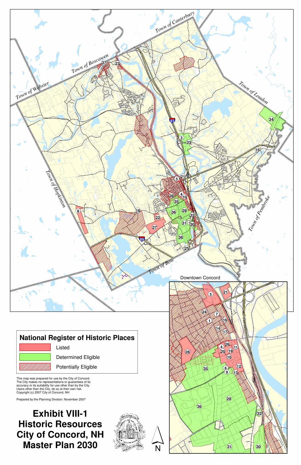
In addition, scattered survey work has occurred, primarily in response to the requirements of Section 106 of the National Historic Preservation Act of 1966 and Section 4(f) of the Department of Transportation Act of 1966. Under the former, any federal undertaking must be evaluated to determine if it will have an effect on historic properties, where a federal undertaking is defined to include construction or demolition, as well as activities pursuant to federal loans, grants, or licenses. The latter protects public parks as well as recreation and wildlife areas by establishing criteria to evaluate any taking of the same for federal or federally funded projects, and the Act specifically includes in its protections those historic resources that are on or eligible for the National Register. These surveys have resulted in the identification of sites, districts and neighborhoods that are potentially eligible for listing on the National Register, as follows: (refer to Exhibit VIII - 1)
• Elm Street Historic Neighborhood (Penacook) • Graham Road Historic Rural Neighborhood • Hall Street Historic Area • Merrimack/Summer Street Historic Neighborhood (Penacook) • North End Historic Neighborhood • Northern Railway • North Main Street Historic Area • Penacook Historic Rural Area • Pleasant Street Historic Neighborhood (Penacook) • South Main Street Historic Area • Stickney Hill Road Historic Rural Area • St. Paul’s School Campus • Upper West End Historic Neighborhood • Washington Street Historic Neighborhood (Penacook) • West Concord Village
3. Heritage Sign Program The Heritage Sign program was initiated by the Heritage Commission in 2006. It provides an opportunity to commemorate the history of Concord through its buildings. All buildings and sites are eligible for this program, regardless of age or use. Through the signs, which are purchased and mounted by a property owner, citizens and visitors alike will learn more about our built environment. To receive a sign through the program, a property owner provides research on the construction date, early owners and, if appropriate, uses of the building to the Heritage Commission for review and approval. In turn, the owner receives a specially designed sign that displays this information, as well as the name of the historic district, area or neighborhood in which the building is located.
VIII- 13
4. Individual Properties & Districts Listed on the National Register of Historic Places (refer to Exhibit VIII - 1) Ref. # Listed Property or District
1. 2 1/2 Beacon Street 2. Beaver Meadow Brook Archeological Site (27MR3) (location restricted) 3. Styles Bridges House, 21 Mountain Rd. 4. Concord Civic District 5. Concord Historic District 6. Chamberlin House 44 Pleasant St. 7. Henry J. Crippen House, 189-191 N. Main St. 8. Dimond Hill Farm, 314 Hopkinton Rd. 9. Lewis Downing Jr. House, 33 Pleasant St. 10. Downtown Concord Historic District 11. Eagle Hotel, 110 N. Main St. 12. Endicott Hotel, 1-3 S. Main St. 13. Farrington House, 30 S. Main St. 14. Reuben Foster and Perley Cleaves House, 64 and 62 N. State St. 15. Leavitt Farm, 103 Old Loudon Rd. 16. Merrimack County Bank, 214 N. Main St. 17. Merrimack County Courthouse, 163 N. Main St. 18. Millville School, 2 Fiske Rd. 19. New Hampshire Savings Bank Building, 97 N. Main St. 20. Old Post Office (now Legislative Office Building) N. State St 21. Page Belting Company Mills, 26 Commercial St. 22. Pleasant View Home, 227 Pleasant St. 23. Rolfe Barn, 16 Penacook St., Penacook 24. Gov. Frank West Rollins House, 135 N. State St. 25. Donald D. Tuttle House, 12 Gabby Lane 26. Upham-Walker House, 18 Park St. 27. White Farm, 144 Clinton St. 28. White Park
5. Historic Sites, Districts & Neighborhoods Determined Eligible for Listing on
the National Register: (refer to Exhibit VIII - 1) Ref. # Property or District Determined Eligible
29. Abbott-Downing Historic Neighborhood 30. Boston & Maine Shops Historic District, off South Main Street
31. Broadway-Rollins Park Historic Neighborhood 32. Concord Gasholder-Holt Brothers Industrial Historic District 33. East Concord Village Historic District 34. Loudon Road Agricultural Historic District
35. Lower West End Historic Neighborhood 36. New Hampshire Hospital Grounds Historic District 37. Penacook Tannery, East St, Penacook 38. South End Historic Neighborhood

VIII- 14
6. Individual Properties Listed on the State Register of Historic Places
• Rolfe Homestead, 16 Penacook Street, Penacook Hard copies of many of the National Register and survey forms are on file in City Hall (Community Development Department), Concord Public Library (Concord Room), and New Hampshire Historical Society. A complete file of all the forms is maintained at NH Division of Historical Resources (19 Pillsbury Street, Concord).
7. Local Historic Regulations a. Concord Historic District - Established in 1967, this is a locally designated historic district created as an overlay zoning district. The Heritage Commission serves as the land use board to administer the district, reviewing and approving alterations to the exterior of buildings and structures and their settings. b. Demolition Review Ordinance - The City’s Demolition Review Ordinance found in Article 26-1-11 of the Code of Ordinances, Title III, Building Code, is administered by the Code Administrator and the Demolition Review Committee, which is a subcommittee of the Heritage Commission. The purpose of the Ordinance is to give Concord citizens fair warning when an older building, which may be important to the City’s history and character, is proposed for demolition. Such warning will enable the community to determine if the building is architecturally or historically significant, to explore alternatives to demolition, and, if such demolition is to go forth, to document the building prior to demolition. The Ordinance is invoked if a building or part of a building is requested to be demolished. Qualifying buildings must be greater than 500 square feet of gross floor area; constructed more than fifty years before the date of application for the demolition permit; and visible from the adjacent pubic right-of-way or public lands. The imposed delay may be a minimum of 10 days and a maximum of 49 days. c. Barn Preservation Easements - Under a State law passed in 2002 (RSA 79-D), municipalities can grant property tax relief to barn owners who can demonstrate the public benefit of preserving their barns or other old farm buildings and agree to maintain their structures for a minimum of ten years by means of a preservation easement. The structure must currently or formerly have been used for agricultural purposes and be at least 75 years old. In Concord, decisions on easement applications are rendered by the City Council, with input from the Heritage Commission. To date, two local barns have been preserved through barn easements, both on Little Pond Road.
F. PRESERVATION POLICIES AND RECOMMENDATIONS 1. Preservation Policies a. Promote the use of preservation easements, particularly in conjunction with conservation
easements, as a means to protect historic farmsteads. b. Undertake a biennial review of all historically significant City-owned properties and those
belonging to the City’s two school districts in order to evaluate the condition and status of the resources.

VIII- 15
Exhibit VIII-1. Historic Resources [Insert 11 x 17 graphic]

VIII- 16

VIII- 17
c. Provide comments and suggestions to the appropriate State agency on any proposed
modification of any State building over 50 years. d. Ensure that developers interested in renovation projects in the City receive accurate
information about the federal 20% historic tax-credit incentive process. e. Promote barn easement tax incentives to barn owners and continue to work with City
Director of Real Estate Assessment to evaluate applications. f. Promote the Heritage Sign Program. 2. Recommendations a. Amend the Site Plan Review and Subdivision Regulations to require that applications
include the identification of all historical resources, such as buildings, structures, cemeteries and stone walls, both on-site as well as contiguous to the subject parcel. Historical resources should also be included in the application checklists. If historical resources are present, the extent of the project’s impact and any mitigation measures should be included as part of the application materials.
b. Review the City of Concord’s Zoning Ordinance and the City’s Building Code with the
assistance of a consultant, to identify regulations that would unintentionally impede the viable rehabilitation or reuse of historical properties without losing their character or historic fabric. If impediments are found, appropriate amendments should be proposed which would eliminate or reduce the impediments to the adaptive reuse of historic structures.
c. Offer assistance in developing best management practices for the maintenance,
rehabilitation, disposition and appropriate reuse of historical properties owned by the City and the school districts. Encourage the school districts and City Departments to seek technical assistance from the Heritage Commission when such properties will be impacted by proposed alterations, new use or disposition.
d. Ensure that reasonable efforts are taken in cluster subdivision applications to preserve
historic farmsteads within the required open space area. e. Consider the preservation of historic farmsteads through conservation and preservation
easements when evaluating new subdivision applications in rural areas. f. Prepare for adoption by the City Council a resolution establishing the Community
Revitalization Tax Relief Incentive (also known as the Downtown Tax Incentive) for downtown Concord and Penacook as well as other village centers as maybe identified. Provide a formal review and comment role for the Heritage Commission on each application.
g. Establish National Register Historic Districts (non-regulatory), with the assistance of grant
funded consulting services, in West Concord, East Concord Village, Abbot-Downing Neighborhood, Broadway-Rollins Park Neighborhood, South End Railroad Yards, North Main St. (between Centre Street and I-393), and South Main St. (south of Freight Street).
h. Complete historical surveys with the assistance of grant funded consulting services, for
North State Street, West Concord Village, East Concord Village and outlying rural areas considered particularly vulnerable to new development and loss of character.

VIII- 18
i. Introduce the concept of Neighborhood Heritage Districts to neighborhood groups and serve
as a facilitator in establishing such districts where local interest and support exists. j. Revise and enhance the existing citywide design guidelines with special emphasis on
historic areas of the community including Downtown Concord and Penacook. k. Research and propose Scenic Road designations, where appropriate, in rural areas of the
City, pursuant to RSA 231:157. l. Complete a city-wide historical survey of historic agricultural buildings with the assistance of
grant funded consulting services. m. Complete a survey of the City’s historic and prehistoric archeological resources.
G. SUPPORTING STUDIES A Capital for New Hampshire, Grace Amsden. Unpublished manuscript in 3 volumes, 1930-1960. An Historic and Architectural Overview & Historic Preservation Assessment of Concord, NH., prepared for the Concord Heritage Commission by Elizabeth Durfee Hengen, 1996. Capital Views, A Photographic History of Concord, New Hampshire, 1850-1930, Elizabeth Durfee Hengen and Gary Sampson. Concord, NH: New Hampshire Historical Society, 1994. Concord Eastside. A History of East Concord, NH. Virginia Colby and Ruth Stevenson. Privately printed, 1993. The History of Concord, Nathaniel Bouton. Concord, NH: Benning W. Sanborn, 1856. History of Concord, James O. Lyford. Concord, NH: Rumford Press, 1903, 2 volumes. Village of Penacook, New Hampshire. An Architectural and Historical View. Elizabeth Durfee Hengen. Concord, NH: Heritage Concord, Inc., 1990. The Village of West Concord, NH, West Concord Villagers, 1976.
���93
Town of Boscawen
Town of Webste
r
Town of Canterbury
Town of Loudon
���89
Tow
n o
f Hopkin
ton
Town of Bow
Tow
n of
Pem
bro
ke
��18��8
��27
��22
��25
��38
��31 ��30
��32��29��36
��35
��28 ��4��10
��21��5
��15
��34
��33��3
��23��37
Exhibit VIII-1Historic ResourcesCity of Concord, NH
Master Plan 2030 ´
��24
��1��7
��16
��14��17
��28
��35
��4��20
��6��9 ��13
��12
��11
��10
��19
��26
��36
��29
��31
��32
This map was prepared for use by the City of Concord.The City makes no representations or guarantees of its accuracy or its suitability for use other than by the City.Users other than the City, do so at their own risk.Copyright (c) 2007 City of Concord, NH
Prepared by the Planning Division: November 2007
Downtown Concord
��30
��21��5
National Register of Historic Places
Listed
Determined Eligible
Potentially Eligible