Embed Size (px)
Citation preview
Sediment Deposition from Hurricane Rita on Hackberry Beach Chenier in Southwestern Louisiana
By Stephen Faulkner, Wylie Barrow, Thomas Doyle, Michael Baldwin, Thomas Michot, Christopher Wells, and Clint Jeske
Hurricane Rita significantly impacted the chenier forests of southwestern Louisiana, an important habitat for Neotropical migratory birds. Sediment deposition was measured along transects at Hackberry Beach chenier, and Rita’s effects on chenier structure and morphology were determined.
IntroductionThe geomorphology
of coastal Louisiana is divided into two distinct units, the Mississippi River Deltaic Plain and the Chenier Plain (Morgan and others, 1958; also see Barras, this volume, for a description of a middle area called the Marginal Deltaic Plain). The Deltaic Plain has been formed in eastern coastal Louisiana by the sediments, water, and energy of the Mississippi River as
natural deltas have been formed and abandoned over the last
5,000 years (Coleman
and others, 1998). During
the regressive or constructional phase of the deltaic cycle, the
system is dominated by freshwater riverine inputs with the formation
of corresponding freshwater marshes and swamps, which
then deteriorate during the marine-dominated transgressive phase (Roberts, 1997).
The Chenier Plain of southwestern Louisiana is a first-order geomorphic feature comprising cheniers, beach ridges, and spits
(linear extensions of land into the water)
and has evolved over the past 3,000–4,000
years as a result of delta switching by the Mississippi
River (Byrnes and others, 1995; Taylor and others, 1996).
Delta switching occurs when the Mississippi River changes course
and creates a new channel to the Gulf of Mexico, resulting in the abandonment of
the old river delta and the creation of a new one. Deposition of muddy sediments from the Mississippi
River, driven by periodic winter cold fronts, has resulted in the development of mudflats along the coast (Roberts and others, 1989). These mudflats are then reworked by wave erosion into
158 Science and the Storms: the USGS Response to the Hurricanes of 2005
sandy chenier ridges dominated by forest vegetation stranded between marsh wetlands vegetated by smooth cordgrass (Spartina alterniflora) (Penland and Suter, 1989; Taylor and others, 1996).
The Chenier Plain in Cameron Parish, La., is particularly susceptible to shoreline wave damage because the absence of significant coastal features and a smooth ocean bottom do nothing to diminish wave energies during hurricanes (Morgan and others, 1958). Tropical storms along the Gulf Coast can supply considerable amounts of sediment that enhance vertical accretion and change the structure and functions of coastal ecosystems (Rejmanek and others, 1988; Cahoon and others, 1995). Hurricane Andrew deposited up to 22.5 inches (57.2 cm) of sediment on Louisiana coastal marshes in 1992 (Nyman and others, 1995); however, there are few other quantitative sedimentation studies on cheniers.
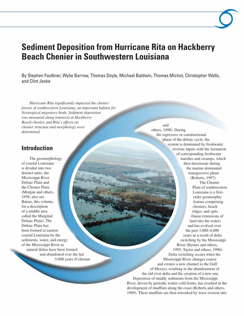
The chenier forests of southwest Louisiana are critical habitat for Neotropical migratory birds (Barrow and others, 2000). During the immediate posthurricane reconnaissance, large amounts of sediment deposition were observed at Hackberry Beach chenier located near the mouth of the Mermentau River. The purpose of this study was to quantify the sediment deposition from Rita and to determine its impact on chenier structure and morphology.
Methods and Procedures
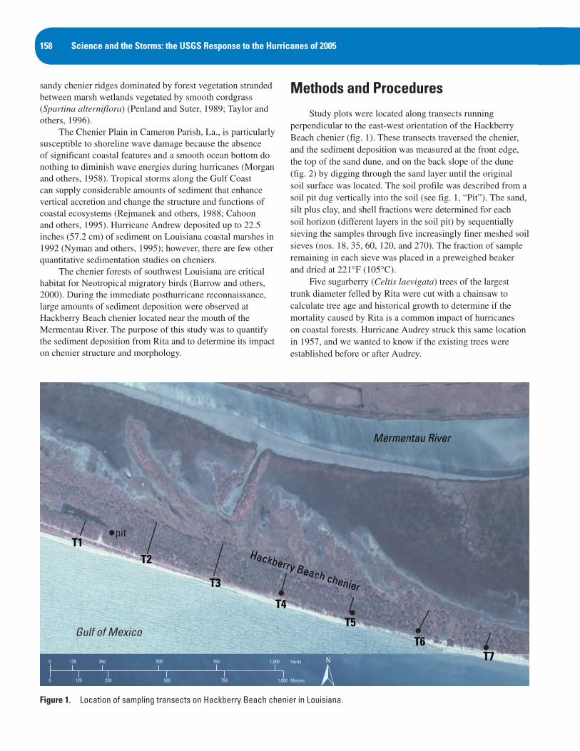
Study plots were located along transects running perpendicular to the east-west orientation of the Hackberry Beach chenier (fig. 1). These transects traversed the chenier, and the sediment deposition was measured at the front edge, the top of the sand dune, and on the back slope of the dune (fig. 2) by digging through the sand layer until the original soil surface was located. The soil profile was described from a soil pit dug vertically into the soil (see fig. 1, “Pit”). The sand, silt plus clay, and shell fractions were determined for each soil horizon (different layers in the soil pit) by sequentially sieving the samples through five increasingly finer meshed soil sieves (nos. 18, 35, 60, 120, and 270). The fraction of sample remaining in each sieve was placed in a preweighed beaker and dried at 221°F (105°C).
Five sugarberry (Celtis laevigata) trees of the largest trunk diameter felled by Rita were cut with a chainsaw to calculate tree age and historical growth to determine if the mortality caused by Rita is a common impact of hurricanes on coastal forests. Hurricane Audrey struck this same location in 1957, and we wanted to know if the existing trees were established before or after Audrey.
Yards
Meters
0
0 500 750250125 1,000
1,000750500250125
pit
N
Figure 1. Location of sampling transects on Hackberry Beach chenier in Louisiana.
Gulf of Mexico
Sediment Deposition from Hurricane Rita on Hackberry Beach Chenier in Southwestern Louisiana 159
Stem sections were measured for size by diameter and sanded with 80–340 grit sandpaper to polish the surface for ring detection and counting. Stem slabs and growth rings were observed under a dissecting microscope to trace ring boundaries and to count growth rings from the pith to the outer bark.
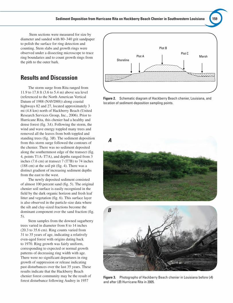
Results and DiscussionThe storm surge from Rita ranged from
11.9 to 17.8 ft (3.6 to 5.4 m) above sea level (referenced to the North American Vertical Datum of 1988 (NAVD88)) along coastal highways 82 and 27, located approximately 3 mi (4.8 km) north of Hackberry Beach (United Research Services Group, Inc., 2006). Prior to Hurricane Rita, this chenier had a healthy and dense forest (fig. 3A). Following the storm, the wind and wave energy toppled many trees and removed all the leaves from both toppled and standing trees (fig. 3B). The sediment deposition from this storm surge followed the contours of the chenier. There was no sediment deposited along the southernmost edge of the transect (fig. 4, points T1A–T7A), and depths ranged from 3 inches (7.6 cm) at transect 7 (T7B) to 74 inches (188 cm) at the soil pit (fig. 4). There was a distinct gradient of increasing sediment depths from the east to the west.
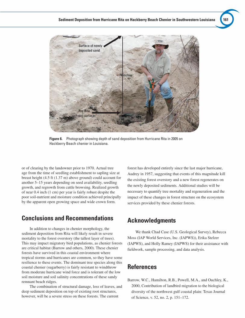
The newly deposited sediment consisted of almost 100 percent sand (fig. 5). The original chenier soil surface is easily recognized in the field by the dark organic horizon and fresh leaf litter and vegetation (fig. 6). This surface layer is also observed in the particle-size data where the silt and clay-sized fractions become the dominant component over the sand fraction (fig. 5).
Stem samples from the downed sugarberry trees varied in diameter from 8 to 14 inches (20.3 to 35.6 cm). Ring counts varied from 31 to 35 years of age, indicating a relatively even-aged forest with origins dating back to 1970. Ring growth was fairly uniform, corresponding to expected or normal growth patterns of decreasing ring width with age. There were no significant departures in ring growth of suppression or release indicating past disturbances over the last 35 years. These results indicate that the Hackberry Beach chenier forest community may be the result of forest disturbance following Audrey in 1957
Shoreline
Plot B
Plot C Marsh Plot A
Figure 2. Schematic diagram of Hackberry Beach chenier, Louisiana, and location of sediment-deposition sampling points.
Figure 3. Photographs of Hackberry Beach chenier in Louisiana before (A) and after (B) Hurricane Rita in 2005.
A
B

160 Science and the Storms: the USGS Response to the Hurricanes of 2005
Yards
Meters
0
0 500 750250125 1,000
1,000750500250125 N
Figure 4. Sediment distribution along transects at Hackberry Beach chenier in Louisiana.
-20
-15
-10
-5
0
5
0 20 40 60 80 100Percent
Dept
h (in
ches
)
Silt/claySandShell
Figure 5. Depth profile of sand, silt-clay, and shell fractions at Pit 1, Hackberry Beach chenier, Louisiana. Field analysis indicated that the deposited sediment was uniformly sand with shell fragments; therefore, samples were not collected and analyzed above the +2-inch depth.
Gulf of Mexico
Sediment Deposition from Hurricane Rita on Hackberry Beach Chenier in Southwestern Louisiana 161
or of clearing by the landowner prior to 1970. Actual tree age from the time of seedling establishment to sapling size at breast height (4.5 ft (1.37 m) above ground) could account for another 5–15 years depending on seed availability, seedling growth, and regrowth from cattle browsing. Realized growth of near 0.4 inch (1 cm) per year is fairly robust despite the poor soil-nutrient and moisture condition achieved principally by the apparent open growing space and wide crown form.
Conclusions and RecommendationsIn addition to changes in chenier morphology, the
sediment deposition from Rita will likely result in severe mortality to the forest overstory (the tallest layer of trees). This may impact migratory bird populations, as chenier forests are critical habitat (Barrow and others, 2000). These chenier forests have survived in this coastal environment where tropical storms and hurricanes are common, so they have some resilience to these events. The dominant tree species along this coastal chenier (sugarberry) is fairly resistant to windthrow from moderate hurricane wind force and is tolerant of the low soil moisture and soil salinity concentrations of these sandy remnant beach ridges.
The combination of structural damage, loss of leaves, and deep sediment deposition on top of existing root structures, however, will be a severe stress on these forests. The current
forest has developed entirely since the last major hurricane,
Audrey in 1957, suggesting that events of this magnitude kill
the existing forest overstory and a new forest regenerates on
the newly deposited sediments. Additional studies will be
necessary to quantify tree mortality and regeneration and the
impact of these changes in forest structure on the ecosystem
services provided by these chenier forests.
Acknowledgments
We thank Chad Case (U.S. Geological Survey), Rebecca
Moss (IAP World Services, Inc. (IAPWS)), Erika Stelzer
(IAPWS), and Holly Ramey (IAPWS) for their assistance with
fieldwork, sample processing, and data analysis.
References
Barrow, W.C., Hamilton, R.B., Powell, M.A., and Ouchley, K.,
2000, Contribution of landbird migration to the biological
diversity of the northwest gulf coastal plain: Texas Journal
of Science, v. 52, no. 2, p. 151–172.
Figure 6. Photograph showing depth of sand deposition from Hurricane Rita in 2005 on Hackberry Beach chenier in Louisiana.
162 Science and the Storms: the USGS Response to the Hurricanes of 2005
Byrnes, M.R., McBride, R.A., Tao, Q., and Duvic, L., 1995, Historical shoreline dynamics along the Chenier Plain of southwestern Louisiana: Gulf Coast Association of Geological Society Transactions, v. 45, p. 113–122.
Cahoon, D.R., Reed, D.J., Day, J.W., Jr., Steyer, G.D., Boumans, R.M., Lynch, J.C., McNally, D., and Latif, N., 1995, The influence of Hurricane Andrew on sediment distribution in Louisiana coastal marshes: Journal of Coastal Research, v. 21, p. 280–294.
Coleman, J.M., Roberts, H.H., and Stone, G.W., 1998, Mississippi River Delta—an overview: Journal of Coastal Research, v. 14, p. 698–717.
Morgan, J.P., Nichols, L.G., and Wright, M., 1958, Morphological effects of Hurricane Audrey on the Louisiana coast: Baton Rouge, Louisiana State University, Coastal Studies Institute technical report no. 10, 53 p.
Nyman, J.A, Crozier, C.R., and DeLaune, R.D., 1995, Roles and patterns of hurricane sedimentation in an estuarine marsh landscape: Estuarine, Coastal, and Shelf Science, v. 40, p. 665–679.
Penland, S., and Suter, J.R., 1989, The geomorphology of the Mississippi River Chenier Plain: Marine Geology, v. 90, p. 231–258.
Rejmanek, M., Sasser, C.E., and Peterson, G.W., 1988, Hurricane-induced sediment deposition in a Gulf coast marsh: Estuarine, Coastal, and Shelf Science, v. 27, p. 217–222.
Roberts, H.H., 1997, Dynamic changes of the holocene Mississippi River delta plain—the delta cycle: Journal of Coastal Research: v. 13, p. 605–627.
Roberts, H.H., Huh, O.K., Hsu, S.A., Rouse, L.J., and Rickman, D.A., 1989, Winter storm impacts on the Chenier Plain coast of southwestern Louisiana: Gulf Coast Association of Geological Societies Transactions, v. 34, p. 515–522.
Taylor, M.J., Byrnes, M.R., and McBride, R.A., 1996, Form/process relationships and geomorphic evolution of the southwest Louisiana Chenier Plain: Gulf Coast Association of Geological Societies Transactions, v. 46, p. 413–422.
United Research Services Group, Inc., 2006, Louisiana coastal and riverine high water mark collection: Atlanta, Ga., submitted to Federal Emergency Mangaement Agency, final report, FEMA-1607-DR-LA, 79 p.
Contact InformationStephen P. Faulkner, Research Ecologist ([email protected]); Wylie
Barrow, Research Ecologist ([email protected]); Thomas Doyle, Research Ecologist ([email protected]); Michael Baldwin, General Biologist ([email protected]); Thomas Michot, Wildlife Biologist ([email protected]); Christopher Wells, Geographer ([email protected]); and Clint Jeske, Wildlife Biologist ([email protected])
U.S. Department of the InteriorU.S. Geological SurveyNational Wetlands Research Center700 Cajundome Blvd.Lafayette, LA 70506