Embed Size (px)
Citation preview

SEDIMENTOLOGY AND MINERALOGY OF SOME
JURASSIC.CRETACEOUS SEDIMENTS OF THE
SOUTHERN EROMANGA BASIN
by IANH VAN DOAN, BSc.
à-¡--^.-)cr n-Á o Å lr\ L+ 1C]
This thesis is the result of resea¡ch undertaken submited by the author in part fulfillment
of the requirement for the Master of Science Degree in the University of Adelaide 1988.

STATEMENT
This thesis contains no material which has been accepted for the award of any other
degree of diploma in any University, and, to the best of the author's knowledge and
belief, it contains no material previously published or written by another person, except
when due reference is made in the text. I consent to this thesis being made available for
photocopying and loan by the librarian of the Universþ of Adelaide upon acceptance of
the degree.
TANH VAN DOAN

CONTENTS
CHAPTER 1 INTRODUCTIONI..1. LOCATION OF THE AREA
1.2. AIMS OF STUDY
1.3. PREVIOUS WORK
CHAPTER 2 REGIONAL GBOLOGY2,I. STRATIGRAPHY
2.1.L. Pre-Mesozoic Basement
2.1.2. Mesozoic sediments
2.1.2.I. ALGEBUCKINA SANDSTONE
2.1,2.2. CADNA-OWIE FORMATION
2.1.2.3. BULLDOG SHALE
2.1.2.4. OODNADATTA FORMATION
2.2. REGIONAL STRUCTURAL GEOLOGY
CHAPTER 3. LITHOFACIES DESCRIPTION3.1. INTRODUCTION3.2. STUART CREEK OPAL FIELD SECTIONS
3.2.I. Stuart Creek Beds
3.2.2. Bulldog Shale (Marree Formation equivalent)
3.3. PELICAN WELL SECTIONS
3.3.1. Pelican Well Formation
3.3.2. Trinity Well Sandstone
3.3.3. Marree Formation
3.4. TRINITY WELL SECTIONS
3.4.1. Pelican Well Formation
3.4.2. Trinity Well Sandstone
3.4.3. Marree Formation
1
1
2
3
3
4
4
4
5
5
6
7
8
Page
I
8
8
9
9
10
10
11
11
11
12
13

CHAPTER 4 SCANNING ELECTRON MICROSCOPY OF
QUARTZ SAND SURFACE TEXTURES 14
4.T. INTRODUCTION 14
4.2. PREVIOUS WORK 14
4.3. SCANNING ELECTRON MICROSCOPE METHODS 15
4.3.L, Method and sample preparation 15
4.3.2. Interpretation of quartz sand grains 15
4.4. SUMMARY OF QUARTZ SAND SURFACE TEXTURES 16
4.4.I. Conchoidal fracture patterns 16
4.4.2. Upturned cleavage plates 11
4.4.3. V-shaped patterns l7
4.5. CRITERIA FOR VARIOUS ENVIRONMENTS 18
4.5.1. Source materials 18
4.5.2. Diagenetic features 19
4.5.3. Glacial environment 20
4.5.4. Littoral environment 20
4.5.5. Aeolian environment 2l
4.5.6. Combined environment 2I
4.s.6.1. GLACIAL AND SUBAQUEOUS COMBINED 2t
4.5.6.2. SUBAQUEOUS AND AEOLIAN COMBINED 22
4.6. RESULT OF QUARTZ SAND SURFACE TEXTURES IN THIS
STUDY
4.7. STATISTICAL ANALYSIS4.8. SUMMARY AND DISCUSSION
CHAPTBR 5 DIAGENESIS5.1 INTRODUCTION5.2 AIM OF DIAGENETIC STUDY
5.3. MINERALOGICAL STUDIES
s.3.1 QUARTZ5.3.2. AUTHIGENIC FELDSPAR
5.3.2.1. Introduction5.3.2.2. Occurrence
5.3.2.3. Development
5.3.2.4. Chemistry5.3.2.5. Formation
23
25
27
27
28
28
28
29
29
29
30
30
3l

5.3.3. KAOLINITE5.3.3.1. Introduction5.3.3.2. Occurrence of kaolinite
5.3.3.3. Chemistry5.3.3.4. Formation
5.3.4. SMECTITE/ILLITE5.3.4.1. Introduction5.3.4.2. Occurrence
5.3.4.3. Chemistry5.3.4.4. Formation
5.3.5. ZEOLITE5.3.5.1. Introduction5.3.5.2. Occurrence
5.3.5.3. Chemistry5.3.5.4. Formation
5.3.6. GLENDONITE5.3.6.1. Introduction5.3.6.2. Previous studies
5.3.6.3. Occurrence
5.3.6.4. Morphological studies
5.3.6.5. Formation of glendonite
5.3"7. PYRITE5.3.7.1. Introduction5.3.7.2. Occurrence of pyrite
5.3.7.3. Formation of pyrite
5.3.8. GLAUCONITE5.3.8.1. Introduction5.3.8.2. Occurrence of glauconite
5.3.8.3. Formation of glauconite
5.3.9. GYPSUM5.3.9.1. Introduction5.3.9.2. Occur,rence of gypsum
5.3.9.3. Formation of gypsum
5.3.10. MINOR COMPONENTS
5.4. DISCUSSION AND CONCLUSION
32
32
32
33
34
34
34
35
3s
36
36
36
36
31
37
39
39
39
40
40
4t42
42
42
43
44
44
44
45
45
45
45
45
46
47

CHAPTER 6 ENVIRONMENT INTERPRETATION 51
6.1. ALGEBUCKINA SANDSTONE (VILLAGE WELL FORMATION
EQUMLENT sl6.2. CADNA-OWIE FORMATION (PELICAN WELL FORMATION
EQUMLENT 52
6.3. BULLDOG SHALE 53
6.4. ENVIRONMENTAL INTERPRETATION 54
6.4.1. Possible transport mechanism of the sediments 54
6.4.2. Evidence of cold climate and ice rafted sediments in the
Cretaceous 55
6.4.3. Ice rafted in the southern Eromanga Basin 56
CHAPTER 7 CONCLUSION 59
REFERENCES
APPENDIX 1
APPENDIX 2

CHAPTER 1. INTRODUCTION
1.1 LOCATION OF THE AREA
The Eromanga Basin is one of the most extensive sedimentary basins in Australia.
It is located in the centre of the Australian continent and stretches from about 200 ø 320
south and from 1320 to 1470 east and has an area of approximately 1.5 million km2.
The northern part of the Eromanga Basin is separated from sequences of similar age in
the Carpenteria Basin by the Euroka Arch and the eastern part is separated from the
Surat Basin by the Nebine Ridge (Fig.1). The Jurassic-Cretaceous sediments of
interest in the southern Eromanga Basin include the Bulldog Shale, Cadna-owie
Formation, and Algebuckina Sandstone. The Bulldog Shale and facies equivalents
which contain both lonestones (i.e. erratic boulders) and boulder conglomerate, are the
subject of this study. These are regionally distributed throughout the centre-north of
South Australia and in western New South Wales (Flint et al., 1980).
1.2. AIMS OF STUDY
The aims of this study are as follow:
1. To determine the geological history of the Bulldog Shale and related units in
the Eromanga basin through f,reld observation.
2. To determine whether the environment of deposition of the Cretaceous clast-
bearing shales included glaciation, through the use of scanning electron microscopy on
quartz-sand surface textures and clay minerals.
3. To determine the mineralogical composition, in particular the clay mineralogy,
and locate the source region for the sediments.
4. To eludicate the diagenesis and burial history and the formation of authigenic
minerals in these sediments.
The fust part of the study involved section measurement and outcrop examination
in parts of the central north of South Australia. In this study, stratigraphy, sedimentary
features, fossils and lithologies were examined by freld study methods. Samples were
collected for examination of mineralogy and qlJartz sand surface features.
Mineralogical studies were carried out by X-ray diffraction, petrography, scanning
electron microscopy and electron microprobe analysis. Quartz sand grains were studied
and particular attention was paid to their surface textures. The results of samples
studied are presented statistically in histograms and tables. A comparision was made
between the area studied and various world-wide localities described in the literature.
1

x¡t Pre-Mes ozoic basement.
Jurassic-Cretaceous basin marginBasement ridges definingJurassic-Cretaceous basins.
0 100 200km.
SCALE
LEGEND:I
I
II
It_I
I
L
I
V
CENTRAL WEST FOLDED
x
x
x
BELT./Broken
Hill
f
^
TownsvilleXX^¡
xt
t
t
x
t¡¡rÁXx
,¡
I
,
trxtt
I
)r
I
x
t
I
I
a
I
(
x
I
t
I
T
x
x
a
x
x
x
x
I
,/
/
)1
t
,,
/,(
x
x
y
,x
t
x
x
I
x
x
x
x
Ix
J
J
"l.i
.l
x x
x I
x x x /MOur ISAx BLOCK ¡
xxXX¡Y xlx
x ARUNTA BLOCK x x
XXXxXx
xxr(I
Alice Spring)<
MUSJd
B ..N.7
x
Y
EROMANGA BASINOodnadatta
;13SI.]RAT BASIN
,:.:¿'.¿: :qLtr I
-tMa¡ree
I(n È(h.
zB ourke
x ,<
GAWLER x x LakeBLOCK ADELAIDE
GEOSYNCLINE Froxxxx me
Xxl(XXXrXXxx
Figure 1: Regional setting of the Eromanga Basin(after Exon and Senior, I97 6)

1.3. PREVIOUS WORK
The search for groundwater led to early geological studies in the Eromanga Basin
(e.g, Rawlinson, 1878). Many of these studies were carried out for the Geological
Survey of South Australia during the 1890's by H.Y.L.Brown. Water-worn boulders
in the Bulldog Shale were first reported by Brown (1894) and his work from 1899 to
1908 sparked curiosity about the origin of these boulders (David, 1906). Woolnough
and David (1926) noted the presence of apparent glacial boulders in the Upper
Cretaceous'Winton Beds. These boulders showed faint marks which resembled glacial
striae and they suggested these had been largely erased by further aqueous action. They
also noted fragments of quartz porphyry that have similarities with Proterozoic volcanic
rocks found in the Gawler Ranges, South Australia.
Jack (1931) described the stratigraphy and the structure of the Great Artesian
Basin. This work provided a basis for regional mapping and led to an approximation to
the current lithostratigraphic division. The first palaeontological work was by
Glaessner and Rao (1955), who dated the plant-bearing strata at Mt. Babbage in the
Flinders Ranges as early Cretaceous in age. Publication of the Gairdner and
Moolawatana 1:250.000 geological maps in 1961 added significantly to understanding
of the local stratigraphy. However, the present stratigraphic nomenclature was
established by Forbes in 1965 when he published the 1:250,000 Marree geological
map. From this work, Forbes offered a comprehensive account of Precambrian,
Mesozoic and Tertiary stratigraphy. Ludbrook (1966) published a major papff on the
biostratigraphy of the Mesozoic sequence in the Southem Eromanga Basin. Freytag et
al. (1967) produced a major assessment of the Jurassic-Cretaceous successions in the
Oodnadatta 1: 250,000 geological map. Correlations were made between type sections
in the Oodnadatta and the Marree area which were described by Forbes (1966) and
Ludbrook (1966). V/opfner et al. (1970) made a major regional assessment of the
Jurassic-Cretaceous sequence on the southern margin of the Eromanga Basin.
Exon and Senior (1976) corelated the Mesozoic sequences of the Eromanga and
Surat Basins. This work detailed the sedimentary environments of the regional
Jurassic-Cretaceous succession in sedimentary basins of central Australia.
Flint et al. (1980) reported on fossiliferous Devonian boulders in the Bulldog
Shale of central-north South Australia. In a discussion of the Jurassic-Cretaceous
boulder shales in the southern margin of the Eromanga Basin, Frakes and Francis
(1988) proposed a model for seasonal climates in the Cretaceous. This work gave
evidence for high latitude cold regions at sea level during the Cretaceous.
2

CHAPTER 2. REGIONAL GEOLOGY
2.1. STRATIGRAPHY
V/hitehouse (1954) suggested the name "Great Artesian Basin", which is applied
both in the sense of a geological structure and as a hydrological basin, to include what
is now known as the Eromanga sedimentary basin, plus the Surat Basin and the
Carpenteria Basin. The 'sratigraphic nomenclature of the Eromanga Basin is
summarized in Figure 2. The lower part of the Cretaceous Eromanga sequence has
been described by Forbes (1966) as the Maree Formation, including the Algebuckina
Sandstone, Cadna-owie Formation and the Bulldog Shale. The Bulldog Shale is
overlain by the Coorikiana Sandstone in the southrwest Eromanga Basin. Ludbrook
(1966), Freytag et aI. (1967) and 'Wopfner et al. (1970) described the sedimentology
and stratigraphy and confirmed that the Jurassic-Cretaceous sequence unconformably
overlies the Palaeozoic-Precambrian basement in northern South Ausnalia. Forbes
(1966) referred to rocks equivalent to the Cadna-owie and the Bulldog Shale in the
northern Flinders Ranges as the Pelican V/ell and Village Well Formation, respectively.
The most widely-exposed rocks in the Eromanga Basin are those of the weathered and
silicified Tertiary cover.
Ambrose et al. (1979) described the type section of the Algebuckina Sandstone
(north of the Oodnadatta Track). The section consists of a basal sequence of kaolinitic
cross-bedded sandstones, including highly weathered porphyry, quartz and agate
clasts. The upper part of the section consists of well-sorted, gritty sandstone and
siltstone. Ambrose et al. also used a silcrete which occurs at the top of the Algebuckina
Sandstone to distinguish it from the oveilying Cadna-owie Formation. Ambrose et al.
(1984) used this silcrete as a criterion to distinguish the two parts of the Mesozoic
sequence in the Preliminary Curdimurka 1:250,000 Sheet.
Barker (1983) used the term Marree Formation to describe a transitional sequence
in the Coober Pedy area. The sequence contains the agglutinated foraminifera,
Texturalia acoonaensis, diagnostic of lowermost Aptian age (Ludbrook, 19661'
Lindsay, 1975). The overlying sequence (Marree Formation) was considered by
Barker (1983) as equivalent to the Bulldog Shale of a similar sequence described by
Pitt (1976).
Benbow (1982), in the Explanatory Notes for the Coober Pedy 1: 250.000
geological map summanzed detailed-stratigraphic nomenclature for the Mesozoic
lithofacies of the Great Anesian Basin. This is shown in table 1.
3

ÀIBlÀtr
ÀITIAN
lftocolllAN
JunAss¡c
cztÐ
t{1, AN}ÍA SS
tfttfBt!IASATAIÍA &
TDDTÎIY ÌTITI SS
c.tDlfA€vlt loDt{ATrDrT IrtIcA}T vttt tonuA,rlD}f
f-xovnr a[txurDtnlt^*t-to rrr'srn
BIAITCXINIfATZNtorlfATl0N
OODT{A}ATTA TOD}f ÀT1ON
lÍoolDnIDGI lIHtsl0lfz HtHBzDM¿C.DDtt
COODIXIÀNAUxl{Bln ATTDACIIoIÌtrllt SS tfD. I
DI'ITDOG SITAII lorltATIox
I
! l[Illoo¡INA ErIcc]Ai xtu¡ln
ltt'no*o r*r-*lVDTTON
'ONHÀÎDN
3('lrrl Àu¡lnÄIlclftna¡'
(!orùrr, 1982)
¡fÀIDtt¡rcotttt
(lorlrr, 1966; 1982)
cÀDxA€'wtr
roDuAll0ÌI
DINIDOC
stfAru
OODI|ADAÎrÀ
IODIIATDIf
lcooPl. ss. HB
ÌfÎ. ArtxÀllDtn ss.}f?ÌfBtÞ
.IÍIITTDIT IODìIA1JON
Y&3Y IÍAICIT(fltyr¡t rl rl., 1966
lfo¡f ur et rl., 1970)
totril^utlnÄrrÄ
(Tlrolrol, 198O)
CADIfA€VT'
IODUÀTDH
z
rÐñtr¡
tJj
OJ
6)Ðo'Ú
IrllrTolfIONHAIIDI{
EI'fIIDOG
sxÀtz
coonl. ss. rB
OODITADATTA
to¡ltArotI
llÀDNlI
lollfAnDll
-,.-.t
STUA¡T CNTIX
ETDS
3ltfa¡fGITIX
O'AT ?ETD(Vuk, 1978;
lficol. 1979ì
Figure 2. Stratigraphic nomenclature of the southern Eromanga Basin

FluvialOuærcps ontheGavler Block.Thickness less th¡n60 metes
Crossbe<lded wNæ k¡oliniticsandsbne , gritty clay and clays.
Conglomeratic in Dart vithpebbles arrd cobbþs ofrou¡rded b arrgular, vNæ bblue quaru anil '¡ariowbosemÊnt lithologies.
Do¡kgrcyo gnycarbon¡ceow anil ¡nas gitæ
clays, sandy in Darl, vilh rarefossil plaff sæm fngmÊnú.
AlgebuckinaSanilsùne(V{opfner, etal ,1970)
Jurasgic
Fluvialcommonlyfemrginiseil black.Ouæropr around thesoulhern marCinof theBulldog ShÂle. Conùclvilh the Bulldog Slnleis slurp. Thicl$essles¡ than 50 metret
Conglomeratic and yellov-brovn feldspaîhic sandsbne,conùinfug abu¡rilant clasl¡ ofquåru and quarEiÈ,porphyritic rhplits and<laci€s.Calcareow inpart.
Cadna-owie
Formatir¡n-MountAn¡aSandsoneMembe¡
(lVopfner, elal1s70)
Cætaceow
Neocomian-Aptian
Marüìe, rl eeDly bleacÌædend ræathere<lbyrnultiphase eventt.
Less than 110 rnÊtes inthickness
Grey o tlark grey shale andsilty shales, miror sa¡rdsonÊlenses, strongly bioturbaÞdrni¡or conc¡etiorury limesbnevilh molhuc casB.B asal part of grey shale withthin le¡rses and, silty shales,cone incora and sandylimesùrres. Horizors of vellror¡¡rdeil cobbles a¡rd boulderof predomirrarrùy quarEiÈ,acid porphyry a¡rd bandedchalcedony.Rare quarEiÞ cl¡sÎs Y¡ilhDevonian bivalws andbrachiopo<1s.
Bnlldog Slnle(Freytag etal. 1966)
MesozoicCætaceowAptian-Albian
less thân 60 metesin thickness
Kaoliniæ and bleacÌæü Drofile.Possibly rcpæsenB multiphaseevents. V/idespnad.
U¡¡¡¡¡ned(Arkaringa Paleosol,Benbow, 1982)
MesozoicTertiaryC¡etaceousPaleogene
ÀcE ETEATIGAÀPHI(;UIfIT LfIITf'[.OGT REttAtf,.
TABLE I Su.mmary of Mesozoic lithostntignphy of tÌæ Great ArÞsian Basin (afær Benbow,t9BZ)
2.1.1" Pre-Mesozoic basement.
The pre-Mesozoic basement is found only on the southern margins of the
Eromanga Basin, in the Peake and Denison Ranges and in deep bore holes (Fig. 1).
The basement consists of Precambrian-Cambrian Adelaidean rocks and late Palaeozoic
strata of the Arkaringa and Cooper Basins. Forbes (1966) and Wopfner g]!¿!. (1970)
described the Burra Group above the Callana Beds and the Wakefield Group near
Davenport Spring, south of Lake Eyre. Nicol (1979) described basement rocks of
Cambrian age in the area of the Stuart Creek Opal Field. The Andamooka Limestone
and Yarra'Wurta Shale overlie the rWilpena Group, which is in turn underlain by the
Umberatana Group (Aberoona Formation and Elatina Formation). At Trinity Well the
basement consists of the Umberatana Group (Tapley Hill Formation and Sturt Tillite).
Near Pelican V/ell the basement consists of the Proterozoic Terrapinna Granite in
contact with volcanics (Phillips, 1983). The Umberatana Group unconformably
overlies the igneous sequence.
Pre-Mesozoic basement also includes the Permian to Triassic fluvial, lacustrine and
possibly restricted marine sediments which form part of the Arkaringa and Cooper
Basin. These sequences are unconformably overlain by the Jurassic-Cretaceous
sediments of the Eromanga Basin.
2.1.2. Mesozoic sediments
Mesozoic sediments were deposited on the surface depression of the pre-Mesozoic
basement. The snatigraphic nomenclature of the southern Eromanga basin in South
Australia was summarized tnFigure 2.
2.1.2.T ALGEBUCKINA SANDSTONE
The name Algebuckina Sandstone was first used by Freytag et al. (1967) on the
1:250,000 Oodnadatta geological map and formally defined by V/opfner et al. (1970)
when describing the section near the abandoned Algebuckina railway siding. Haris(1970) suggested the age of this sequence was late Jurassic to early Cretaceous
(Neocomian) from studies of the microflora.
The Algebuckina Sandstone, including the Mt. Anna Sandstone member,
unconformably overlies the pre-Mesozoic basement and represents the basal unit of the
southern Eromanga Basin. The rock consists mainly of white kaolinitic medium-
grained sandstone and contains conglomerate with well-rounded quartz pebbles at the
base. Laterally discontinuous shale and siltstone units commonly display climbing
4

ripple laminations, and contain plant fossils. There is an absence of marine fauna,
suggesting a fluvial environment (Wopfner et a1., 1970), Ambrose (1980) suggests in
particular a braided stream environment.
The Mount Anna Sandstone Member is part of the Algebuckina Sandstone and
reflects a trough of fluvial deposition north of Lake Torrens (Wopfner e]!31., 1970).
The sequence consists of coarse-grained feldspathic sandstone and contains
interbedded conglomerate indicating a fluvial-deltaic environment of the latest
Neocomian regression (Flint et al., 1980). Forbes (1982) noted the derivation ofporphyry boulders from the Proterozoic Gawler Range Volcanics.
2.1.2.2. CADNA-OWIE FORMATION
The name Cadna-owie was also first used by Freytag et al. (1967) and the
formation was defined by Wopfner et al. (1970). The type section is located 4 km
southwest of the abandoned Algebuckina railway siding. The unit generally
disconformably overlies the Algebuckina Sandstone (Wopfner e]!31., 1970). The
contact may be transitional above the Algebuckina Sandstone, or there may be a low
angle unconformity (Forbes,1982). The Cadna-owie ranges in age from Neocomian
to Aptian (Early Cretaceous) and represents brackish to marine environments of the
first marine trangression in the Eromanga Basin.
The upper part of the Cadna-owie Formation consists of laminated, silty tomedium-grained brownish sandstone with intercalations of shale and siltstone. The
sandstone is locally calcitic, feldspathic, pyritic and micaceous. Quarøite and siltstone
clasts of pebble to boulder size are also distributed throughout the sequence.
Carbonaceous shale is locally developed in the sequence.
The common presence of pyrite and iron sulphide facies indicates that much of the
sediment was deposited under reducing conditions (Wopfner et a1., 1970). The Cadna-
owie Formation appears to overlap the Algebuckina Sandstone, and anoxia may have
originated during trangression. The Pelican V/ell Formation, described by Forbes
(1966), is the equivalent of the Cadna-Owie Formation in the northern Flinders Ranges
2.1.2.3. BULLDOG SHALE
The marine Bulldog Shale conformably overlies the Cadna-Owie Formation. Itwas first described by Freytag (1966) from a section 8 km south of Bulldog Creek,
east of the Peake and Denison Ranges. It is considered to be of Aptian to about middle
Albian Age (Ludbrook, 1966; Morgan, 1980). However, Alley (1987) in a study of
5

the palynology of the base of Trinity'Well section suggested a marine trangression in
that area during the early Neocomian.
Lithologically the Bulldog Shale is a dark grey to black shale and siltstone with
thin interbeds of sandstone. Krieg (1982) noted that the base of the Bulldog Shale is a
dark, coffee-brown shale containing small lenses of fine to coarse sand. The sediments
are locally carbonaceous, silty, glauconitic and pyritic in a shaley-mudstone. The
shaley-mudstone contains some concretionary limestone and cone-in-cone structures.
The glauco-pyritic shale is indicative of alternating oxic-anoxic conditions (McKirdy et
a1., 1986). The Bulldog Shale was deposited in marginal marine to shallow marine
environments, probably less than 200 metres deep, as indicated by foraminifera and
pelecypods.
Boulders of mainly quartzite and siltstone are distributed throughout the Bulldog
Shale but concentrated near the base (Forbes, 1982; Flint et al., 1980). Fossilised
wood occurs sporadically and large rounded boulders are distributed throughout the
sequence.
2.1 .2.4. OODNADATTA FORMATION
Conformably overlying the Bulldog Shale is the Oodnadatta Formation (Freytag et
a1.,1967). The basal Coorikiana Member of the Oodnadatta Formation was described
in the area of Coorikiana Creek 40 km southwest of Oodnadatta. Lithologically it is
typically a fine-grained quartz, feldspathic and glauconitic sandstone with some
coarser-grained pebbly lenses. Thomson (1980) and Forbes (1982) used the name
Coorikiana Sandstone for this unit. The overlying V/ooldridge Limestone Member of
the Oodnadatta Formation consists of calcareous and sandy siltstone with limestone
concretions and contains a marine micro- and macro-fauna of late Albian age
(Ludbrook, 1966). The age of the Oodnadatta Formation thus is Albian. The
environment of the Oodnadatta Formation is shallow marine with a low rate of
sedimentation and hardly affected by tectonic instability (Krieg, 1982). The Mount
Alexander Sandstone Member is the uppermost part of the Oodnadana Formation,
consisting of dark-grey silty shale and claystone with intercalations of femrginous
carbonaceous and micaceous sandstone. This unit is thought to be equivalent to the
basal part of the Blanchewater Formation in the Marree area (Forbes, 1982).
The uppermost Mesozoic unit is the non-marine Winton Formation, which
conformably overlies the Oodnadatta Formation and is in turn overlain by Early
Tertiary deposits above an erosional surface. The latter are referred to as the Eyre
Formation (Wopfner et al., 1974).
6

2.2. REGIONAL STRUCTTIRAL GEOLOGY AND TECTONIC
SETTING OF THE BASIN
Several subsurface basement rises separate the Jurassic-Cretaceous basins of
South Australia, New South Wales and Queensland. The Nebine Ridge separates the
Eromanga Basin and the Surat Basin. The Euroka Arch separates the Eromanga basin
and Carpenteria Basin. The southern Eromanga margin is limited by the Adelaidean
rocks of the nofthern Flinders Ranges. To the southeast the Eromanga Basin overlies
and abuts against the Broken Hill Block; to the northwest it is limited by the Arunta
Block and to the northeast by the Mount Isa Block (Fig. 1).
The Eromanga Basin strata gene.rally thicken and deepen from the southem margin
in a northerly direction. The structure of the Eromanga Basin is characterised by broad,
generally low-amplitude folds and northeast trending faults. A number of breached
regional anticlines and troughs can be recognized in the southwest margin and central
area of the Eromanga Basin. Many of the structures of the basin are defined by
seismic, gravity and core data. Kreig (1982) described the Dahousie Anticline, a broad
structure of the southem Eromanga Basin, as a growth structure of Late Cretaceous-
Cainozoic age. Seismic profiles show its origin dates from the base of the Bulldog
Shale, in the form of a simple, steady, curving surface with several folds and faults
superimposed on the anticline form (Kreig, 1982).
In the northeast, there are a number of anticlines, domes, synclines and faults
overlying the Cooper Basin. These structures are formed by compaction over basement
ridges and troughs which were affected strongly by the Late Palaeozoic orogeny. The
trend is generally parallel to the north-northeast direction developed in the Cooper
Basin and the basement (Exon and Senior,1976). A major downwarp movement
occur¡ed during the Cretaceous, therefore the area over the Cooper Basin was a
depocentre, and the Jurassic-Cretaceous units are generally thin elsewhere.
Deformation of the Mesozoic and Early Tertiary sequence occurs within
Cretaceous formation.(Exon and Senior, 1976). Most folds have a decreasing
amplitude in the younger cretaceous sequence, and the movements on faults become
less. The Tertiary sequences are also folded and displaced in the Dalhousie Anticline
region. There is evidence of movement both during and after Cretaceous time (Exon
and Senior,1976; Kreig, 1982)
In general terrns, the structural pattern is dominated by normal faults and related
anticlines. These anticlines are commonly drape folds over deeply buried basement
faulted blocks. There was intermittent movement during sedimenøtion, which resulted
in thinning over these blocks @xon and Senior,I976).
7

LMUSGRAVE V
BLOCK'vv!
vwv
vvvvv
T
'889.DBCts8e.cP1/2.LSIS'
.8Se.CP3/lLIB.889.8DL.81 )
I.t
I#
Coober PedvFJ
oqoØ
27q" 889.85
. Manee aas.ae r\
.12.86.14
889.86.22 r889.86.30
b
¡
,f
I
I
I
Þb 889.85 Trini w .86.29889.85./-t (\ 8E9.86.8
tua¡t Creek 86.
889.86.11 I ::889.86.ADELAIDE
GEOSYNCL
Figure 3.1: Sample locations of the area studied in the Eromanga Basin.(Map after Forbes, L982)
0 100 200 300
SCALE (km)
LEGEND :
Undifferentiated Tertiary and Quatemary sediments '"
Jurassic-Cretaceous outcroPsPalaeozoicLate Pre cambri an -Cambri an
Older Precambrian and volcanicsLimits of the Eromanga BasinSample location associated with clast bearing shale
etÀ
vvv
t
vvvvV\/VVGAWLER CRATON,
vvvvvvvvvvvwvvv
\T\/VVVVWvvvvwvww
S,9Vw9
vvvv!r'
vJvV!
YY
ae2
OFFICER
BA

CHAPTER3. LITHOFACIES DESCRIPTION
3.1. INTRODUCTION
Several outcrops were examined and sections measured from the southern margin
of the Eromanga Basin during joint field excursions with fellow researchers. The
sections are described in this chapter. The effects of gypsification, silicification and
calcification made sections difficult to describe. Moreover, some of the original
sedimentary structures are poorly preserved due to bioturbation and compaction. The
sections presented are mainly from exposures at Stuart Creek Opal Field, Trinity Well
and Pelican'Well from the southern Eromanga Basin (Fig.3.1). In addiúon, Mesozoic
sediments in one bore hole (Toodla #1) were sampled and examined. (chapter 5)
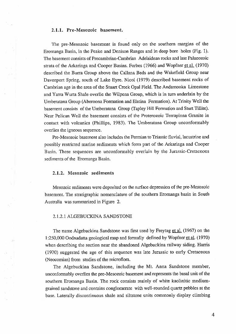
3.2. STUART CREEK OPAL FIELD SECTIONS
Basal sandstone and boulder conglomerates of the Mesozoic sequence crop out at
Yarra'Wurta Cliff and Stuart Creek Opal Field to the north of Lake Torrens (Fig.3.2).
These are the most southerly known outcrops and mark the boundary of the southefn
Eromanga Basin with the Willouran Ranges.
In research on the precious opal deposits in the area, Vnuk (1978), Barnes and
Scott (1979) and Nicol (1979) made detailed studies of the geological history of the
area. The Mesozoic sediments are deeply weathered and have been kaolinised. For this
study, three sections were measured in the area. To the NNE of Lake Torrens,
Mesozoic outcrops occur as "mesa" and "pimple" land forms which are the result of
intense weathering processes. Measured sections from Yarra Wurta Cliff and Stuart
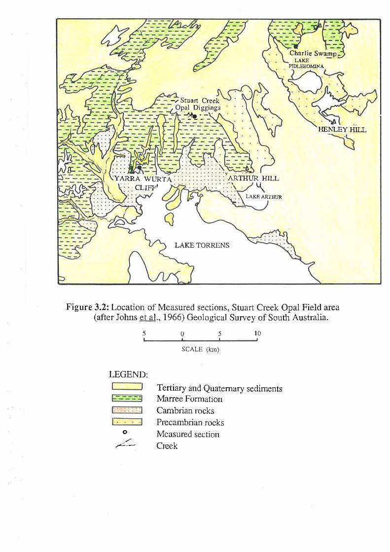
Creek Opal Diggings are shown on Figure 3.3.
3.2.1. Stuart Creek Beds
The Stuart Creek Beds (Vnuk, 1978) overlie the Cambrian basement at Yarra
Wurta Cliff. The base of the beds is marked by an unconformity and a conglomerate
layer on the undulating surface of the Cambrian shale (Plate 1a). At the base is a
conglomerate which contains green silt and quartzite clasts of pebble and small cobble
sizes in a silty-sandy matrix. The conglomerate beds range from 0.3 to 1 metre in
thickness. Above the conglomerate bed is a sequence of dark green shale grading up
into a sequence of white or yellow to pale brown, micaceous, glauconite, silty to very
fine sand. The sand is generally friable and shows patchy stains of iron oxide. In
places, the Stuart Creek Beds contain thin lenses of coarse sand to pebble
8
G.
Charlie SwampLAKE
PIDLEEOMINA
Stuart CreekDiggings
-1t¿'-ITENLEY HILL
YARRA WURTA ARTHUR HILLCLIFF, \
LAKE ARTHUR
LAKE TORRENS
Figure 3.2zLocation of Measured sections, Stuart Creek Opal Field area(after Johns et al., 1966) Geological Survey of South Australia.
5 0 5 l0
LEGEND
SCALE (km)
Tertiary and Quaternary sedimentsMarree FormationCambrian rocks
Precambrian rocksMeasured section
Creek
o
.¿..-
sh-Ô:
-o- -_5_
¿_o_ o_
-ìsP-
éH _-B:
STUART CREEKOPAL DIGGINGS
l6
T4
t2
l0
m YARAWURTA CLIFF I
Red mottled zone
red pebble and shale clasts
YARAV/TJRTA CLIFF 2
€
T Jasperlite,White, silicified
kaolin iúc,poorl y sorted
White kaolinitic micaceouswiù erratic rounded bouldersand cobbles
Km
Grey green, glauconiticforam inifera (brackish),lenses ofcoarse sand gypsihed.
CHARLIE SWAMP
'... (NIcoL, 1979)
T
zF-
frztr
ú,IT
vz
=Ks
8
6
4
2
Km
IeF-l
:É
âðJJÊa
L
\Erraúc bouldeìs.andcobbles \
red mottled zone
Enatic bouders ofquarøite-siltstone
scour ba;e
Sh
Glauconiæ
Kaoliniæ
Shale
SandS
Km V/hite gypsum powderThin pebble layerenatic Pebblesquartzrte,
pebbles
laminaæd green
shale and silsroneclasts up to 20 cm
Ks
KsPwn
0
Siltsnne pebbles ---
LEGEND:
Õ Bor¡lder T Tertiary Sediments \
S Cross bedding Km Marree Formation
æ Pebble lense Ks Stua¡t Crcek Beds
@ Foraminifera e Cambrian
.* Unconformity Pwn Prcca¡nbrian
V Fossil. plant
Ñ Hummocky cross stratification
0m mark based on the Pre-cambrian basement
\ \
oõ
k
B
G
M
Gr
Bioturbaúon
Heavy gypsified
Mud
Gravel
Figure 3.3: Conelated sections and sedimentary facies between Yarra
Wurta Cliff, Stuart Creek Ooal Dieeines and Charlie Swamp.


ìfl,t .'\,:i

conglomerate or patches of dark brown silty sand. The sequence is overlain by the
Bulldog Shale which contains foraminifera of lowernost Aptian age (Ludbrook,
1966; Lindsay, 1975). Thus the age of the Stuart Creek Beds is Aptian or older.
3.2.2. Bulldog Shale (Marree Formation equivalent)
The Bulldog Shale overlies the Stuart Creek Beds in the Yara Wurta Cliff and
Stuart Creek Opal Digging sections or laps directly onto the undulating surfaces of the
Precambrian basement. The base of the Bulldog Shale is marked by a conglomeratelayer. The conglomerate layer consists of quartzite, siltstone, and shale pebbles withclosely-packed coarse sand and a silty marix.
Above the conglomerate layer is a sequence of green-grey to pink-white poorly-bedded kaolinite-and alunite-rich silty shale with erratic boulders or lonestones, up to 1
metre in diameter. Most of the boulders have rounded and polished surfaces and are
randomly oriented. They are distributed throughout the formation (Plate 1b). Arounded quartzite boulder was measured at 2.65x1.00x0.80 merres by Nicol (1979).
The silty shale facies is bioturbated and mottled. These strucrures were described
and discussed by Barnes and Scott (1978:, I97g) and Nicol (1979). Nicol (1979)used the term biomottling to describe this texture. The present author also uses the term"biomottling" sensu Nicol.
Dark green-grey layers contain agglutinated brackish-water foraminifera (Plate.
1c). The foraminifera were identifred as Textularia anacooraensis (Dr. B. Mc.Gowran.
pers. coms.). According to Ludbrook (1966) and Lindsay (1975) this fossil isdiagnostic of the lowermost Aptian. At Stuart Creek Opal Diggings, the Bulldog Shale
is deeply weathered and contains secondary gypsum and halite. These minerals infilljoints and fractures (Plate.1d) or have penerated the unconformity surface between the
basement and Mesozoic stata.
The Bull Dog Shale is overlain by crossbedded, (fluvial) sandstone of Tertiaryage. This starts at the base with a medium to coarse kaolinitic sandstone layer. The
sediment source was possibly from the Ma¡ree Formation.
3.3 PELICAN WELL SECTIONS
The Mesozoic sequence in this area was described by Forbes (1966) when he
published the Marree 1:250,000 geological map and in a review paper in 1982.
Sequences in the area (between Pelican Well and Village Well, around Western Spur,
west of Mt Freeling; Fig. 3.4) were also correlated. In the present study several
sections were measured along Pelican Creek. These sections were PWN1, PWN2,
9

Plil/N3 and VV/. The sections were also correlated and are shown in figure 3.5.
Exposures of these sediments are cha¡acteristically infrequent and poor. The major
Mesozoic sequence occurs in segments and beneath flat plains. Since no fossils were
found the sections were correlated on a lithological basis.
3.3.2. Pelican Wetl Formation
A section (approximately 25 metres) of the Mesozoic sediment was measured in
the Pelican'Well area, along Pelican Creek. This sequence lies unconformably on
Precambrian basement at PWNI and PWN2. The basal part consists of a conglomerate
layer representing a lag gravel deposit, and is laterally continuous throughout the
section. It contains rounded clasts such as quartzite, siltstone and shale derived from
the Precambrian basement (Adelaidean), within a grey, yellow silty sandy matrix. The
conglomerate layer ranges in thickness from 0.8 to 1.3 metres. At the contact plane
with the Adelaidean there is a thin (few centimetres), femrginised sandy layer. This
layer is a distinct band which can be easily recognized at the unconformity surface.
Above the basal conglomerate layer is a sequence of gleen, gIoY, yellow, silty
sandstones containing pebbles, cobbles and boulders. The boulders are concentrated
near the base of the sequence. However, there are large numbers of clasts randomly
distributed throughout the sequence. The largest measu¡ed boulder in the Pelican Creek
section is about 1.5 metres in diameter.
Most of the silty layers have small bioturbated traces or burrows, which are
infilled with a darker silty-very fine sandstone. Organic matter is abundant throughout
the section. However, no fossil plants were found. There are several conglomerate
layers and channel fills, and fining-upward sequences were also recorded near the
upperpartof the sequence (Plate le, lf¡.
3.3.3.Trinity Well Sandstone
Above the da¡k geen-grey silty bioturbated sequence is a unit of medium to coilse
feldspathic-kaolinitic sandstone. Its colour varies from white to grey and it is stained
with iron oxides. Good outorops of the Trinity Well Sandstone are seen at PIVN¡. At
Pelican Creek, the type section, the unit consists of large cross bedding sets and tidal
units (Plate 1g) (Lemon, 1938) and can be interpreted as indicating an estuarine
environment (N. Lemon, pers. coms.). Cross-bedding is the most prevalent structure
in the Trinity Well Sandstone (Plate th). The thicknesses of cross beds range from 50
cm to several metes. The cross beds are predominantly planar but some trough cross-
bedding was seen at the Pelican Creek Section. Sedimentary structures in this unit
10

ê Ooloo Mine
PRooF
aHILL
Y
ç . MT. DISTANCE@
VILLAGE
Â
a . MOT]NT GARDINER .\
o^{î+\ ----- \ A (.
MOUNT FREELING
PELLICAN WELLt-
\.A
V/ILDMAN BLUFF/r
6
s
Figure 3.4 : LOCATIONS OF MEASURED SECTIONS, TRINITY WELL'
PELICAN WELL AND VILLAGE WELL, EAST OF
MT.FREELING. (after Forbes, 1965)
l0
LEGE,ND:
5 0 5
SCALE ftm)
Tertiary and Quatemary sediments
Marree Formation
Pelican Well Formation
Village Well Formation
Precambrian rock
Well
Creek
Measured section
re
¡
,/::o

_-õ'5_
e-. &_.___9. _
ó
-1.-o
Manee Formation
(Bulldog Shale
equivalent)
Triniry Wellsandstone
Pelican V/ellFormation
(Cadna-owie
Formationequivalent)
Precambrianbasement
m
60
20
0
Trinity Well (Try)
(general)
mm 60
60
frî
VillageWell
(general)
40
*40
40
20
¿0
*Village V/ell and Western Spur
(Forbes, 1982)
Pelican V/ell
(general)
Figure 3.5: Conelated sections of Pelican Well, Trinity Well Village Wella¡rd Western Spur
o
=Õ-:_-
.ë_
-ed-=---+. o-
- <J-' O__ _õ-_
-_o-_ -
ô_
Legend see fig.3.3

include scour-based channels and cross-bedded sandstone yielding paleocurrent
directions ranging from 2400 to2700.
The basal part of this unit is marked by an intermittent boulder-conglomerate layer.
Boulders and pqbbles characteristically are well-rounded with occasional very angular
clasts. The clasts have a similar composition to the lag gravel deposit above the
Adelaidean. At the Village \ilell and'Western Spur sections, there is an equivalent body
of sandstone overlying the upper part of the Pelican Well Formation. The basal paÍ is
also marked by a conglomerate layer resting on an unconformity surface. In thin
section the Trinity Well Sandstone consists of quartz, feldspar, muscovite and kaolinite
and other minor components including biotite and heavy minerals (Plate 2a,2b).
3.3.4. Marree Formation (Bulldog Shate equivalent)
Above the Trinity \ilell Sandstone member is the Ma¡ree Formation, which is a
weathered white to grey silty-shale which is overlain by Tertiary silcrete. The Marree
Formation is an onlap unit of the last marine trangression in the area. There are well
correlated sections of the Mesozoic sediments in this area (Pelican Well, Village V/ell
and Western Spur area; Forbes, 1982). Correlated sections are shown on figure 3.5.
Therefore mineralogical studies and environmental interpretation of the studied area
will be discussed together with the Trinity Well sections.
3.4. TRINITY WELL SECTIONS
Trinity Well is located about 20 km NE of Pelican Well (Fig. 3.4) Most of the
geological studies in the area have been undertaken by Forbes of the (SADME)
Geological Survey of South Australia (1966; 1982). On the MARREE sheet the name
Trinity V/ell Formation was used for sandstone in the upper Marree Formation.
Sections were measured in an area of 25km2.
3.4.1. Pelican Wetl Formation
The Pelican Well Formation overlies Precambrian basement above an
unconformity surface.(Plate 2c,2d ) The base of the type section is marked by a
conglomerate layer (Plate 2e) but elsewhere the basal part of the formation consists of a
dark brown feldsparthic coarse sandstone. Lag gravel deposits above the unconformity
surface are one to two metres in thickness. At Recorder Hill, the Pelican V/ell
Formation consists of a yellow to grey pebbly mudstone, which in part is silicified,
calcified or gypsified. The clasts vary in size from pebbles to boulders and the biggest
11

are up to 2 metres in diameter. In thin section, the calcareous conglomerate samples
consist of rounded-to-subrounded pebbles, cobbles and coarse sands in a cemented
calcareous silt matrix. The clasts consist of siltstone, quartzite and shale, possibly from
the Precambrian basement. Correlated sections are shown in figure 3.5.
The bio¡¡rbated mudstone contains small mixtures of glauconite grains, and darker
mud layers or sparse pyrite peloids. At the bottom, the sequence is marked by a
calcareous pebbly sandstone with worm burrows (Thallasinoides type). In thin
section, the calcareous pebbly sandstone consists of rounded-to-subrounded pebbles,
cobbles and coarse sands in a cemented calcareous silt matrix. The clasts consist of
siltstone, quartzite and shale, possibly from the Precambrian basement. Bioturbation
structures are patchily distributed and the burrows vary from2"m,m to a few
millimetresindiameter. Thus, there is evidence of faunal activity in the sediments (fecal
pellets and bioturbation). However, no fossil fauna was found in the Pelican
Formation. Fossil leaves and pollen were found in the middle part of the Recorder Hill
section. Alley (1987) studied the palynology of the Pelican Well Formation and
concluded that the sequence contains pollen diagnostic of early Neocomian age.In the
uppermost parts of the Pelican Well Formation carbonaceous material appears in
calcareous, hummocky cross-stratified beds (Plate 2Ð and cone-in-cone structure is
seen in the TR16, TR6, CMSl and CMS2 sections.
3.4.2. Trinity Well Sandstone
Conformably overlying the Pelican Well Formation is the Trinity V/ell Sandstone
Member. The basal part of this unit is also marked by a conglomerate layer. The
sandstone is fine-to-medium grained, poorly sorted and contains abundant sub-
angular to angular quartz grains. At the base, there are several noticeably coarser,
occasionally pebbly and bouldery layers. Matrix material is usually silty but less
abundant and inparts a porous nature to the sand body. Minor components include
coarse mica flakes and'weathered feldspar grains. Most of the sandstone is cross-
bedded with current directions ranging from 1450 to2950, but in general, most of the
paleocurrent directions trend toward the north west. No fossils were recorded in the
Trinity Well Sandstone Member in this area.
t2


tlf
1¡
a
a\TC!
3
fr\
ol
Ç¿
uL
'.F
2g

3.4.3. Marree Formation (Bulldog Shale equivalent in age )
The Ma:ree Formation unconformably overlies the Trinity Well Sandstone. The
unconformity surface is found at the base of a 1 or 2 metres layer of red iron oxide-
cemented sandstone. These indicate an old weathering surface of possible early Aptian
age (N. Lemon pers. coms). However, at TR1 the red sandstone layer was'eróded and
Bulldog Shale lies on the unconformity surface,suggesting the red sandstone. The
Marree Formation onlaps the Trinity V/ell Sandstone in the area. The Marree
Formation consists of dark grey to pale grey glauconitic shale with some pyritic
components. Overlying the Marree Formation is the Tertiary Telford Gravel. The
thickness of the gravel ranges from one to several metres.
Lithologies of the Pelican Well and Trinity Well Sections are similar. The
dominant minerals in the silty shale facies of both the Bulldog Shale and the Pelican
Well Formation in the Trinity Well area include quartz, glauconite, authigenic
potassium feldspar, illite/smectite and pyrite. In addition, there are secondary minerals
such as gypsum and halite. Detailed sample descriptions are given in appendix 1.
t3

CHAPTER 4. SCANNING ELECTRON MICROSCOPYOF QUARTZ-SAND SURFACE TEXTURES
4.1. INTRODUCTION
The study of sand-grain surface textures has become an established technique in
the study of clastic sediments. Through this method lithological characteristics which
are extremely important in environmental reconstruction can be recognized,leading to
improved interpretation of ancient environments.
Superior depth of focus and wide ranges of magnification are the great advantages
of the scanning electron microscope (SEM). Indeed, the use of SEM to study sand-
grain surface textures is a new sedimentological method providing valuable information
for environmental reconstruction (Krinsley and Marshall, 1987). The instrument is
proving more useful over time. V/ith scanning electron microscopy of sand-grain
surface textures, as with many other forms of geological work, sampling and
laboratory work must be done carefully. The study of sand-grain surface textures must
be used in conjunction with statistical methods in recognizing depositional
environments.
4.2. PREYIOUS WORK
Several early papers wete published on the electron microscopic examination of
sand grain-surface textures (e.g, Beiderman,lg62; Krinsley and Takahashi, 1962a,
1962b, Krinsley et al., 1964). These workers were concerned with finding surface
textures that were indicative and diagnostic of particular environments.
Research increased when the scanning elecron microscope (SEM) became popular
in the late sixties-early seventies. Krinsley and co-workers systematically studied
qtJartz sand. Quartz sand grains from various environments were collected and
experimentally examined in the laboratory. The results gave correlations of textures
with environments, and diagenetic, mechanical and chemical transportation factors
were recognized. The method was used widely in the late seventies and early eighties
(Higg, 1978; Whalley, 1978; Chen g,1978; Middleton and David,1979; Whalley and
Langway, 1980; Mazzullo et a1., 1982). These works have contributed significantly to
environmental reconstructions. There has been a recent revival of research on sand-
grain surface textures (Sharp and Gomez, 1986; Rai, 1987) and the most important
was the publishing of "Clastic Particles" by Mazzullo and co-workers (1987). This
volume included experimental work and examined clastic particles in various
environments. It was also confirmed that the examination of sand surface texture is
l4

one of the modern methods which shows remarkable results compared with traditional
sedimentological techniques.
The quartz-sand surface texture techniques are most effective when combined with
statistical analysis (Margolis and Kennett, l97l; Baker, 1976; Strass, 1977; Bull,
1978 Higg, L978; Hill and Nadeau 1984; Rai, 1987). The statistical method gives
more reliable results and minimises erroneous conclusions about characteristics
inherited from earlier depositional events. But statistical analysis cannot produce new
insights unless the origin and development of sand surface textural data are well
understood.
4.3. SCANNING ELECTRON MICROSCOPE IV,IETHODS
4.3.L. Method and sample preparation
Samples were collected from bottr outcrops and cores from various locations (Fig.
3.1). These ì#ere then dispersed and washed clean of clays and cements. Sand grains
from the 65-200 pm fraction were oven dried at 600C until entirely dry.Their general
features were first studied with binocular microscope in order to estimate percentages
of polycrystalline grains and the dominant mineralogy in the size fraction. About 5 to
15 gr of the sand fraction (65-250 pm) were boiled for ten to fifteen minutes in
concentrated hydrochloric acid to remove carbonate, then rinsed throughly with
distilled water. Iron oxide was removed when necessary by boiling in 20Vo stannous
chloride solution for 20 minutes. Organic materials were removed by a strong
oxidizing solution of 1.5 gr ofrpotassium dichromate and potassium permanganate
dissolved in 15 ml of concentrated sulfuric acid. In using this technique to remove
organic debris, samples required further boiling with2oVo hydrochloric acid to remove
stains caused by the potassium dichromateandpotassiurn{permanganatcThe samples
were then washed in distilled'water several times and oven-dried until entirely dry.
Quartz grains from this material were randomly selected and mounted on
aluminium specimen stubs, which were coated with double-sided adhesive tape. The
stubs were then coated under a standard vacuum evaporator. The use of gold-palladium
for coating tended to give the best results.
4.3.2. Interpretation of quartz sand grains
Quartz-sand surface textures are observed on the premise that grain morphology is
diagnosticofthe environmental deposition history from which the grain has come
(Krinsley and Doornkamp, 1973). The environment types that can be differentiated on
15

this basis are shown in figure 4.1. This conceptual model shows the interrelation
among surface features, source materials, and four major environments: glacial,
aeolian, littoral and diagenetic environments. Krinsley and Doornkamp (1973), and
Krinstey and Marshall, (1987) indicated that interpretation of environment must follow
certain rules:
1. No single feature seen on the surface of one or more sand grains is sufficient to
make an interpretation of the enviromental conditions.
2. Any diagnostic characteristic must be observed on several grains.
3. Interpretations must be based on statistical methods to ensure the characteristic
observed represents a statistically significant sample.
In addition, overprinted features must be accounted for (to be discussed in 4.5.6).
Many workers confirm that common features have been found among grains from
many environmental conditions (Margolis and Kennett, l97l; Krinsley and
Doornkamp,lg73; Margolis and Krinsley,1974). These include conchoidal fracture
pattems, upturned cleavage plates and V-shaped patterns. These features are produced
by chemical and mechanical action. Therefore the interpretation of quarø-sand surface
textures becomes an assessment of the presence or absence of those features and the
degree of natural alteration of these features.
4.4. SITMMARY OF OITARTZ-SAND SITRFACE TEXTIIRES
4.4.I. Conchoidal fracture patterns
Conchoidal fracture patterns consist of a series of irregular broken surfaces,
commonly stepped in a series of shelt-like ridges or arc-step markings. Krinsley et al.
(1964) showed that these are probably caused by acoustical wave phenomena.
Margolis and Krinsley (1974), confirmed by Sharp and Gomez (1986) showed that as
quartz is compressed in static fatigue tests, cracks may propagate in irregular motion,
each producing a microfracturing event associated with ultrasonic radiation. The
formation of conchoidal fracture patterns is strongly controlled by crystallographic
orientation. The size of the area affected can vary from I pm to as much as one thfud
of the grain surface. Conchoidal fractures of varying dimensions and abundance have
commonly been observed on sand grains from many environments:- fresh and
weathered granite or granite gneiss, glacial environments, aeolian environments,
colluvium and also by mechanicatly fracturing of quartz in the laboratory.
16

Fig.4.l Conceprual model showing interrelation among
surface features and environmental contents
SOURCE I\{ATERIAL -Angular and poor sorting-Conchoidal fractures-Diagenetic features inherited from
earlier sediments-Crystal moulds-Solution and precipitation of silica
GLACIAL -Extremly angular and poorly sortedgralns
-Large conchoidal fractures greaterthan I pm
-High relief-Irregular outline-Flat cleavage plates-Step like fractures-Arc steps
AEOLIAN -Rounded and well sorted-Mechanical uprurned plates-l-ow relief features-Cracks-Frosting
SUBAQUEO US -Rounded grains and well sorted-May show polished surfaces-Variable rounding of corners-Small conchoidal fractures <1pm-Mechanical V-shaped pattems-Oriented etch pits
(low energy beach)
-Irre gul ar pi tted surface-Oriented etch pits-Frosting (aeolian burial)-Precipitation of silica:
.Irregular
.Regular (crystal faces)-Other diagenetic forms
(e.g., crystal moulds)
DIA G ENESIS

4.4.2. Upturned cleavage plates
Some mechanical features are ubiquitous on quartz sand grains found in natural
environments: upturned cleavage plates consist of a series of thin, parallel plates, often
continuous and observed to be parallel to the cleavage direction. (Krinsley and
Doornkamp,1973). They are commonly found in small grains (200 pm in diameter or
less). The plates, if unaffected by solution and precipitation, are jagged, irregular in
height and generally broken on top. Upturned cleavage plates appeü to be oriented
along traces of cleavage planes (generally r 1011 or z 0111; Krinsley and Doornkamp,
1973) and on crystallographic faces. However, diagenetic or other chemical action
usually affect the plate form, either by solution or precipitation. In acid conditions,
silica precipitates on quartz to form a series of disconnected small crystal prism faces.
They are often overprinted on the earlier-formed mechanical surfaces (Baker, 1976;
Rai, 1987). Thus the height and thickness of cleavage faces are closely related to
precipitation and solution. The size of the grain is thereby changed along with the
appearance of a new grain image where there was previously only a flat surface.
Flat freshly-upturned cleavage plates are features commonly found in glacial
environments and are possibly caused by glacial grinding and crushing actions. Brittle
fracture of quartz can give rise to them. Chemically formed upturned-cleavage plates
are common features of active diagenetic environments within which the solution and
precipitation rate of silica is at least moderate.
4.4.3. V-shaped patterns
V-shaped patterns were first described by Krinsley and Takahashi (1962). They
distinguished between features formed by chemical and mechanical action, and
described the mechanical V-shaped patterns as the result of subaqueous impacts
between grains.
Mechanical V-shaped patterns are characteristic of beach action (Krinsley et a1.,
1964; Krinsley and Donahue, 1968). Margolis and Kennett (1971) reported that the
density of of V-shaped patterns increases with distance of transport from the source.
However, mechanically formed V-shaped patterns are also found on quartz sand grains
from continental shelves, intertidal environments and turbidities in deep sea sediments
(Baker, 1976; Hampton et al., 1978; Middleton and David,1979; Mazzullo et al',
1982; Middleton and Anderson, 1987).
Mechanical V-shaped patterns are essentially notches cut in the tops of cleavage
plates and may be produced by removal of small chips as the result of collision with
other grains. If these mechanical V-shaped patterns are aligned they may form curved
t7

grooves. Abrasion causes shearing of fragments from the grain during tangentialmovement, when static and dynamic forces acting on the grains in contact exceed grain
strength. Early workers suggested that dense mechanical V-shaped patterns are afunction of turbulent currents, this is shown in figure 4.2 (Margolis and Kennett,
l97l; Krinsley and Doornkamp, 1973). However, Middleton and Anderson (1937)
explained that the mechanical V-shaped patterns are related to grain size parameters.
Their statistical study shows that the mechanical V-shaped pattern density is related tothe degree of exposure of grains to impacting due to fluctuations of hydraulicconditions in the suspension zone. Thus, small grains which spend a long time in the
suspension zone have higher mechanical V- shaped pattern density than larger grains.
A high density of V-shaped patterns has been recognised (Heezen, 1963:Mazzullo eta1.,1982) on sand grains from turbidites from abyssal depths. Mazzullo et al (1982)
reported that sand grains from shallow water shelf turbidites also have high densities ofmechanical V- shaped patterns.
Chemical V-shaped patterns are the result of silica dissolution or etching. Incomparison with mechanical V-shaped patterns, most chemical V-shaped patterns have
sharp corners, deep grooves, and show oriented etch pits. Furthermore, the chemical
components show silica precipitation and dissolution, which are formed on upturned
cleavage plates and chemical flat cleavage plates in a complex diagenetic environment.
4.5. CRITERIA FOR VARIOUS ENVIRONMENTS
Krinsley and Margolis (1968) described criteria for various environments and
these were confirmed by Krinsley and Doomkamp (1973). Recognition of diagenesis
and four sedimentary environments is basic to the application of the statistical methdto the study of sand grain surface textures. These are source material; glacial; littoraland aeolian environments.
4.5.1. Source material
The original source of most qtrara grains is granite and granite gneiss. Weathered
bedrock also yields crystalline quartz. If quartz grains delivered from these rocks a¡e
unweathered after sepamtion. The grains may have characteristics such as conchoidal
breakage patterns on large grains and flat cleavage plates where the grains are small.
Since all surfaces of a grain are not exposed to weathering simultaneously, in some
part, a grain may have extremely flat faces unaffected by chemical action, while otherparts may contain features resulting from chemical solution and precipitation (IGinsley
and Doornkamp, 1973). The results, upturned cleavage plates, chemical V-shaped
18

ó
5
4
3
EIL
oÈ
o.Idq.
ooþE
z
)
0 1000 50
Percentage of sand grains with impacr pits on more rhan 10",, of surface
Figure 4.2Evolution of subaqueous impact features on quartz sandgrain surfaces. The production of mechanical V-shaped pattems increases from river to high energybeach and turbidite environments (Margolis and
Kennett, I9lI; Krinsley and Doornkâffip, L9l3).
ENVIRONMENTS
x River
tr Low-rurbulence beach
I Moderate-turbulence beach
a High-turbulence beach
O Shelf and basin sands
A Deep-sea turbidites
A Subantarctic deep-sea turbidites
Experimental saturation limitT
6í*A
A
A
A
^
A
AA
A
A
-$-\"?\"
òs-A
Limit of **rflj9t9s
o
o
oooo
¡
10
\[oòerord a oa
o O a
beacha
River Low-turbulence
to
o a
x a
x ¡x ¡
x xtr
x

etching and smoothing of some surfaces, are common features occuring duringweathering of the source rocks.
The environmental interpretation of quartz-sand surface textures may be
complicated by factors controlling weathering; temperature, humidity, pH, Eh and
mineralogical composition of the source rocks. Also, quartz sand surfaces are often
interpenetrated by other minerals, leaving crystal moulds. Chemical features may
appear in up to 95Vo of the sample with an extremly complex mixture of solution and
precipitation phenomena occuring in the source material.
4.5.2. Diagenetic Features
Diagenesis results from the processes of physical and chemical change in a
sediment during lithification. Morphology of grains can vary as a function of the
relationship between textures created by the previous chemical or mechanical effects by
thediageneticenvironment in which the grains have been deposited (Krinsley and
Doornkamp,I9T3)
Chemical action is manifested on quartz-sand-surface textures by solution and
precipitation; the results of chemical action are regularly found as triangular etching
pits, irregular solution pits, deep grooves, precipitated plates, crystal overgrowths and
other features of silica precipitation (Krinsley and Doornkarrry,7973).
Detrital q\afiz sand grains are strongly affected by chemical action, and pressure
solution is most important in the movement of silica, resulting in the formation ofsmooth surfaces or upturned plates (Fournier, 1960; Pittman,1972). Ancient glacial
grains differ slightly from modern glacial grains by showing the effecs of diagenesis:
etch pits, smooth surfaces and featureless fracture planes. Chemicat activity related to
the presence of interstitital water reduces glacial features through time (Margolis,
1968). Pittman (1972) observed a phenomenon of abrasion solution of quartz insandstone and suggested etching and cavities may result from pressure solution. Asexplained by Krinsley and Doornkamp (1973), the solution of silica is caused by
insufficient silica concentration in the environment; the enrichment of silica in the
environment may cause local supersaturation leading to the precipitation of silica.
Precipitation was found to be affected by the particle size and porosity of the rock.
On the other hand, the silica precipitation rate controls the quartz-sand surface texture.
At high rates, as in aeolian conditions, silica forms an undulating surface without any
sharp projections. At moderate rates silica will form on upturned plates or may create a
new set of upturned plates. At low rates, silica precipitates on the projections on the
grain surfaces or forms qua.rtz growth crystal faces where there is sufficient pore space
between grains (Pittman, 1972; Krinsley and Doornkamp, 1973).
t9

4.5.3. Glacial environment
A variety of glacial sand grain-surface textures have been studied in the literature
since the work of Krinsley and Takahashi (1962). These include Krinsley and
Margolis (196a); Margolis and Kennett (1971); Blackwelder and Pilkey (1972);
Krinsley and Doornkamp (1973); Krinsley and Margolis (1969); Whalley and Krinsley
(1974); Whalley (197S); Middleton and David (1979); Mazzullo et al. (1982, 1984);
Hill and Nadeau (198a); Gomez and Small (1983), Rai (1987) and Hodel et al.
(1938). The principal surface textures observed on quartz sand grains from
contemporafy glacial environments from part of these publications are summa¡ized in
table 3. Margolis and Kennett (1971) explained that these features are the result of
glacial grinding and crushing and a combination of fatigue fractures, This was shown
to result from "surface characteristic brittle fractures" by Sharp and Gomez (1986).
The quartz-sand grain surface features found on recent ice-rafted grains are also
consistent with features on grains of known ancient glacial environments.
Whalley and Krinsley (I974) observed quartz sand grains from subareas of the
glacial environment, and demonstrated that no surface textures were observed which
could characterize any particular glacial subenvironment. However the formation of
general glacial features were recognizeÀ,in their study.
Recent statistical studies on sand-grain surface features from glacial environments
include Strass (1978), Hill and Nadeau (1984) and Mazzallo et al. (1984). The
statistical studies characterize glacial sand grains by the presence of unique features and
help to distinguish imprinting features from various environments. Mazzullo and
Anderson (1987) showed that surface features from tillites and glacial-marine sand
grains in Antarctica were different. Previous investigations give a firm foundation for
further research on ancient and modern glacial features.
4.5.4. Littoral environment
Characteristic features of the littoral environment include the formation of
mechanical V-shaped patterns, polished surfaces and small blocþ conchoidal breakage
parterns. Mechanical V-shaped patterns and polished surfaces are important criteria for
littoral environments. The effect of abrasion is cumulative and the source sands often
have former impact pits from older transportation cycles. The result of overprinting
cannot be avoided (this will be discussed in the section on combined environments).
Grains from high-energy beach environments contain mechanical V-shaped
patterns (see V-shaped patterns) and conchoidal breakage patterns. However, these
20

KDI}ÎSI'Y & SMATIIY( t s72)
r(nllTr,xY &DOO¡I{XÀH}( 1s73)
KDmSIZy & ìfA¡COIIS( 1s6s)
vlta[ttv & xnD$LtYlte74)
rflrarllY (.r.978)
vl(åJrly & tÀlTcwaY
(teE0)
colltz Al{D, suAlt( le83)
nÀI (1e87)
XODI! r¡ r1. (19EE)
IttrDtEct
CIACIAI
6IACIAI.
GlACIAI
SI'INACIACIAT
ZNGI,ACIÄI
SIJBGIACIÄI
SI'3CI,ACIÀ[
lxlztIMIt{TAt
ST'SCIACIAI
ÏIG}T I,T\'ZT
ron tlvxl
GIÀCIAI
CI,ÀCIAI.
I}IVIDONMIITTsÀlftrzD
x
x
x
x
x
x
x
x
x
AITGVIANOI¡f[INZ
x
x
ttrGtfDllIlt
x
x
x
x
x
x
x
x
x
CONC¡ÍOIDAtrBttAxacz
x
xxx
x
x
x
sTltltDsvtlacts
x
x
x
x
x
BDIAIçAGIEtoctcs
x
x
x
x
G¡OOVZS,SNIAIINDZ}TTATIOTf
x
x
x
x
x
DOUNDINC+ "lDGt
AStASIOtf'
Table 3. Summary of principal surface textures observed on quartzsand grains from contemporary glacial environments andexperimental glacial studies.
conchoidal breakage patterns differ from glacial counterparts, by being smaller (l to2pm) and less abundant. Grains from low energy beaches contain chemical V-shaped
patterns or V-etch pits which result from chemical action.
Grain size is a critical parameter which affects the formation of littoral features(Middleton and Anderson, 1987) due to the fact that small grains spend more rime insuspension and hence are more pitted by abrasion than larger grains. Low relief and the
degree of rounding a¡e also considered to be common features of littoral environments.
4.5.5. Aeolian environment
Grain size parameters are also important in the formation of aeolian features. Large
aeolian sand grains are strongly affected by wind abrasion. Abrasion causes impact
between grains, leading to the production of mechanical upturned plates with rounded
corners, edges and low relief. Conchoidal breakage patterns also appear in the aeolian
features. Howevet, Krinsley and Doornkarnp (1973) explained conchoidal breakage
patterns in aeolian environments as due to a single event during violent wind abrasion.
These tend to be smaller in size compared with the conchoidal breakage patterns
produced by glacial environments.
The porosity of aeolian deposits is larger than in any other environment, hence
aeolian features are often affected by diagenetic features. Frosting is one of the most
common features. Frosting can be used as diagnostic features of aeolian sand grains. Itconsists of raised platforms of roughly polygonal outline (Plate.3a) created chemically.
The artificial abrasion of large grains of quartz in wind tunnels produces upturned
plates very similar to those formed in natural environments (Beidennan, 1960). The
height and spacing of the plates are related to energy input and velocity of the
environment.
4.5.6. Combined environments
4.5.6.r. GLACTAL AND SUBAQUEOUS ENVTRONMENTS COMBTNED
Sand often is transported into the marine environment by subaqueous turbulent
flows or by ice-rafting. Sand grains from glacial environments are reworked byaqueous mechanisms, leading to the superimposition of aqueous abrasion on features
from the former glacial episode. If grains have been tr¿nsported for a long time under
the high flow regime, it may not be possible to recognize a former glacial episode insurface textures. However, in short term transport by water currents, some grains inthe sample will show both episodes in the complex history.
2l

Blackwelder and Pilkey in 1972 showed that grains with glacial features are
prcsent in many samples from the continental shelf north of Delawa¡e, eastern USA.
The shelf shows a combination of two material sources. The northern source is
cha¡acterized by glacial features and the southern one by non-glacial features (beaches,
river and some aeolian). The combined features are interpreted by Blackwelder and
Pilkey as due to multiple cycles of abrasion. Recent research shows that quartz sand
grains often display a combination of several sources (Strass, 1978; Mazzullo et a1.,
1982 &.1987; Hill and Nadeau, 1984; Rai, 1987).
4.5.6.2. SUBAQTJEOUS AND AEOLIAN COMBINED
Coastal dune sand is the most typical environment for the study of sand-grain
surface textures of combined subaqueous and aeolian environments. Most grains have
not travelled far from the beach, hence the abundance of subaqueous features, such as
mechanical V-shaped patterns. Baker (1976) studied coastal dunes and confirmed this
result. Baker also showed a decrease of subaqueous environmental features inland,
while those thought to be characteristic of the aeolian processes increased. However,
simple statistics prove that it is not possible to distinguish beach from coastal dune
sand by the use of diagnostic features of quartz sand grain-surface textures alone
(Baker, 1916).
River and aeolian environments commonly occur together in seasonal climates
where wet and dry seasons are significantly different during the year. Sand grains
from the Colorado River contain some rounded grains with frosted surface textures,
indicating that these grains were of aeolian origin. Diagenetic features are predominant
in this environment, resulting from a high silica concenEation in the water that contacts
the quartz. However, reworking of sand grains from river beds in the wet season
causes subaqueous mechanical features. If quartz grains have been moved by water far
from the source rocks, mechanical V-shaped patterns of subaqueous features will be
found overprinting aeolian features.
4.6. RESULTS OF OUARTZ SAND SURFACE TEXTURES IN THIS
STUDY
SEM examination of sand-grain surface textures of Cretaceous sediments from the
southem Eromanga Basin, central-north of South Australia, led the author to recognize
five sediment types. The environmental interpretation of these sediment types is briefly
discussed below.
22

*. Type I. The surface marking on quartz sand grains of type one represents an
aeolian environment. Aeolian features are predominant in this grain type and include
rounded grains, particle flatness, large surface depressions and mechanical upturned
cleavage plates. These features are the result of wind abrasion. Chemical features
include frosting and adhering-clay particles on grain surfaces which are also diagnostic
features indicating aeolian environment (Plate 3b, 3c,).*. Type II. Sand grains from this environment have a distinct distribution of
surface features that are caused by the mechanical abrasion on the beach and surfzone.
These sand grains contain well- rounded, V-shaped patterns, curved grooves and
polished surfaces typical of littoral environments. Chemical action has slightly affected
the precipitation of silica. But the mechanical features of subaqueous environments can
be recognized on the grain surface (Krinsley and Doornkamp, 1973). Type IIrepresents linoral environment (Plate 3d,3e, 3f).
*. Type III. Surface textures of type III consist of glacial grains which have
features such as highly angular outline, conchoidal fractures, parallel stepped surfaces,
high relief, well developed elongate prismatic grains, etc. due to glacial grinding and
crushing. The glacial features are often partly affected by diagenetic processes, but
overall the grains still exhibit the major features of a former glacial episode @late 39,
3h, 4a, 4b, 4c, 4d, 4e,4f).*.Type IV. This type represents diagenetic features, which include grains which
have been completely overgrown by silica or other authigenic minerals, and show
strong dissolution of original grain surface features as grains have been subjected to
repeated, prolonged periods of chemical weathering. Type IV also represents some
problematical grains (Plate 49,4h,5a, 5b, 5c, 5d,)*. Type V. Type V has the combined features of glacial and subaqueous grains.
Glacial features are overprinted by latter subaqueous features (Plate 5e, 5f, 59, 5h)
4.7. STATISTICAL ANALYSIS
Semiquantitative analysis of the quartz-sand surface textures was described byMazzullo et al. (1984) and Hodel et al. (1988). The results of studies of quartz-sand
surface textures of the Jurassic-Cretaceous sediments are presented in table 4 and
the representative samples are shown in histograms of frequency versus grain types
Gig. 4.3). These histograms show for each sample, the percentage of grains exhibiting
the characteristic features of various environments. Certain differences fromenvironment columns are readily apparent. The abundance of grain types is identified
directly on the frequency axis on the left hand side and the proportion of the grain types
can be read on the relative frequency on the right hand side of the histogram. The
23


tØ yn2ØØrtt 2'J883 Øø56 25 l1t.)
,t<
t -..
,z
'.?' t{ tlØy¡2ØØkU 169E3 ø152'øL
3a
3c
3f
I
- -l.l. t ì 1111-- rij :L
,, ,nç,


4b
\
_WØl^n2Øøktt ¿748¡ 8ø2.r A9 5E *
:i'l a>'4
? øøø3 / ø3 ¡1VØl¡n2øØkU ?74E
tË- \
4g


.-._._/â
rl'rl I ' '!

&û0.ó
lt9ff.rr À¡¡.É
!Et"¡ú.¡ À=Lä 0.3
o.2-
I
ó
I
z
0
05
(,)zl¡¡foÊl/h
4
I
I
0
ozÊ¡Þof¡¡4h
03
o.2
3¡ I
3
GR,AIN TYPES GRNN TYPES
o 8IO o .Btoó 6
5
4
3
I
0
EE9.EÁ.5 Er5 b= ls03
0.2
0.1
t¡.g,[É.ra
C)zg:ÞÊl&lÉ
4 (.)zf¡¡ÞdÞúh
0.3
0.2
0.1
3
2.
0 23GRAu^ TYPES
4 523GRAIN TYPES
4
o ßlo
lo 8fo $9.¡5.8 n=l t
EE9.&¿2L)7f¡¡Þdr¡¡&Þ
6
Uzf¡Ðdf¡¡Élr
0.3
o,2
0.1
4 o.2
0.12
0
23GRAIN- TYPES
GR,AIN TYPES
8io n Rrn2L 40 Io'8tq.8ú-14 ¡=f6
Tot¿l n=130- 16
Oz.^tà tL
=t¡84l¡
0.4
03
o2
0.t
>30(Jz
Jnf¡&rto
0.1
4
0 0234
CRAI¡| TYPËS GRAIN TYPES
Figure 4.3. Histograms of frequency versus grain types of the clasts-
bearing sediments of the Cretaceous Southern Eromanga Basin
Type 1 = aeolian Type2= subaqueous Type I = glac'ial
Typc4 = diagenesis type5 =glacial & subaqueouscombincd

Table 4. Comparision of probability of glacial population of the Getaceoussediment to glacial occurcnce world wide
Fennessy (1984)
Bulldog Shale
(Cretaceous)
Hill &Nadeau (1984) Strass.(1977)
(Recent) (Recent)
ThisStudy
Chetaceous
@3 ranges from) 0.29 to 0.60 0.30 to 0.61
*. P3 = Probability of glacial grains in the sample
0.39 to 0.63 0.10 to 0.40

relative frequency axis also shows the distribution of the environmental population.
For example, sample 889.86.14 shows that the frequency of glacial grains is 14, and
the relative frequency (R(Ð) of glacial grains is equal to 0.40. In another words, the
probability is 0.40 that a quartz sand grain choosen randomly will give glacial features.
But, if the probability of glacial and combined glacial and subaqueous are added the
total probability of glacial grain will be 0.6 to 0.8 (1.0 is certain).
Glacial, subaqueous and diagenetic features were the predominant features
observed in these samples. These were mainly affected by dissolution and precþitation
of silica on the primary surface textures. Hence, the mobilization of silica has reduced
the number of glacial and subaqueous features in the sediments.
Most of the samples showed diagenetic features but some representative samples
(with less diagenesis) taken from beneath the lonestones and boulder beds showed the
probability of glacial features up to 0.40.
A comparison with various histograms from the literature reveals similarities to
glacial environments elsewhere, as shown inTable 4 From this table we can see that
the probability of glacial environments for the Cadna-owie Formation and the Bulldog
Shale (0.10-0.40) is similar to those for modern sediments of the Canadian Beaufort
Shelf (Hill and Nadeau, 1984), where R(f) ranges from 0.30 to 0.61, and for modem
coastal glacials, which ranges from 0.39 to 0.63 (Strass, 1978).
Furthermore, quartz-sand surface textures of the Bulldog Shale, Davenport Spring
area studied by Fennessy (1984) provided a table of grain morphologies. From this
table the probability of glacial environment ranges from 0.28 to 0.60.
In natural environments, most samples contain two or more grain characteristics
(Blackwelder and Pilkey, 1972: Knnsley and Doornkamp, 1973; Hill and Nadeau;
1984;Mazzullo and Anderson, 1987). The presence of aeolian grains in a number of
samples indicates subsequent erosion and deposition in a marine environment of grains
subjected to wind abrasion processes and rew_orking in duné Ueách environment (Mazzullo and
Anderson, 1987). A dry climate may have allowed the development of local dune frelds
and generation of the aeolian features. These aeolian grains thus are consistent with
paleoclimatic evidence which suggest a cold and dry environment like the north west of
Canada and Northern slope of Alaska.
Sample 889.85.8 contains subrounded grains showing subaqueous and glacial
features (type V = 28Vo,ll = 33Vo and trI =22Vo and type IY=167o). This sample has
undergone a substantial amount of high energy subaqueous transport in the littoral
environment, which has overprinted abundant glacial features. Howeve , sample
889.86.8 (type V =27Vo,II=20Vo and trI =2O7o and type lY=20Vo) contains a number
of fresh glacial grains and also subaqueous grains and imprinting features; this sample
has undergone less reworking and may have been deposited within the fluvially
24

influenced part of the Trinity Sandstone. The relative proportionsrof glacial and
reworked grains indicate the r_elative influence of littoral environment (Hill and
Nadeau, 1984). Thu_s a greater influence of reworking near.shore must be, as
expected, in the form of polisñed grains mixed with angular grains.'
4.8. SUMMARY AND DISCUSSION.
Scanning electron microscopy was effectively used to study quartz-sand surface
textures of the Jurassic-Cretaceous sediments in the southern Eromanga Basin. The
method provided valuable information concerning the provenance history of clastic
sediments. Semiquantitative methods can be successfully used in the study of quartz-
sand surface textures. Grain type classification is an important tool and leads to the
determination of regional sources of the clastic sediments and environmental
interpretation.
About 937o of qtrartz grains exhibit composite features, as they contain surfaces
attributed to glacial, subaqueous, aeolian and diagenetic activities. Among primary
glacial features as mentioned earlier, conchoidal fracture patterns, angular outlines,
high relief and arc steps are the prominant features in the sediment. Besides these
features, it is interesting to note that many fractured and unfractured grains show small
adhering particles which appear similar to precipitation platelets characteristic of glacial
environments. A considerable number of samples exhibit both diagenetic and glacial
features. In addition, some samples show that glacial features tend to have angular
shape (elongate, triangular, quadrahedral) and fractures indicating that the grains were
deposited while being broken mechanicalty and had undergone little reworking.
euartz grains from the Cadna-owie Formation and the Bulldog Shale illustrated
both glacial and subaqueous features (Pelican Well and Trinity Well Sections). The
glacial features were attributed either to crushing and grinding of the basement rocks or
reworking of nearby ancient glacials (Precambrian and Permian tillites). However, it is
difficult to see how some grains with glacial features could have escaped the
continuous buffeting which occurs in nearshore marine environments. Although the
sediments from group V shows subaqueous features associated with glacial features
(the suites of textures superimpose of II and III), therefore the environments of
modification is probably the combination of the two. It is unlikely that group III
represents reworked or slumped slope deposits of Group II sediments.
25

The slight rounding of many qu;artz grains, the degree of imprinting of aqueous
impact pits and diagenetic features on glacial grains, suggest very little reworking
following their formation during a glacial episode. The presence of several grain types
in most of the samples, including glacial, subaqueous and aeolian grains, is evidence
that sediments have been subjected to varied environments in the southern Eromanga
Basin during the Cretaceous.
In most of the samples studied, the effects of silica solution increase with
decreasing grain size, and are apparently most prevalent in ttre Bulldog Shale samples.
Stuart Creek Opal Field quartz shows extreme dissolution. The study of quartz-sand
surface textures in carbonate-cemented sandstones, led to the conclusion that
secondary quartz and authigenic K-feldspar are the major factors which destroy quartz-
sand surface textures
The sediments r,r/ere brought into the area by subaqueous transport mechanisms
and by rafting. The superimposition of subaqueous actions and chemical features on
glacial grains is the result of subsequent transport mechanisms and diagenetic
procesess in the study area.
If some of the sand from the Bulldog Shale was transported into this part of the
basin by icetrafting it seems likely that glaciation occurred regionally in the Cretaceous
Some early Neocomian to Aptian sand grains were eroded by subaqueous or glacial
erosion, underwent fluvial and nearshore marine cycles of aggradation and eventually
were iepesited in the area studied.
26
CHAPTER 5 DIAGENESIS
5.1. INTRODUCTION
Diagenesis has been defined by many workers in different fields of study, such as
Burley et al. (1987), who defined diagenesis for clastic diagenetic environments as
"the sum of those processes by which sedimentary clasrtc assernblages attempt to reach
equilibrium with theír environmenr" (pp.189). They also distinguished three types of
diagenetic environment: depositional environment or surface chemistry or eogenesis;
burial or subsurface conditions or mesogenesis; and weathering of surface conditions
or telogenesis. The diagenetic study and environmental reconstruction must therefore
be based on the mineralogical composition of clastic sediments. In the present work,
authigenic minerals were studied to provide important information on palaeo-
weathering or diagenetic changes within the sediments. Diagenesis revealed in most
sediments results from the dissolution of unstable minerals, and controls the formation
of authigenic minerals.
Depositional environmental reconstruction is related to the eogenetic mineral
assemblages, these minerals equilibrating between sedimentary geochemical conditions
and interstitial pore fluids. For example, in the fluvial lacustrine environments of the
Late Jurassic (Algebuckina Sandstone), the mineral assemblage reflects a low pH and
oxidizing conditions. However, in the trangressive marine environments of the
Cretaceous (Cadna-owie Formation and Bulldog Shale), the authigenic mineral
assemblage reflects a high pH andreducing conditions.
Mesogenesis is a more complex process involving pressure and temperature,
leading to an increase of reaction rates. The processes cause losses of interstitial pore
fluid and large amounts of fluid are released into the environment. The released fluid
may serve to transport a large amount of material (i.e., numbers of ions, gas, oil, etc.).
The degree of mesogenesis can be predicted as a function of depth. In addition there
are other factors involved in the formation of mesogenetic mineral assemblages.
Sediment exposed under weathering conditions by uplift or desiccaúon leads to
alteration in the telogenetic realm. These processes are influenced by meteoric water
and climatic conditions.
Scanning electron microscopy is very important in paleoenvironmental analysis.
The value of textural properties and mineraloglcal composition of the rock as indicators
of palaeoenvironment is well known. Hence, the effects of diageneisis on textural
properties of rocks must be well understood.
27

5.2. AIMS OF DIAGENETIC STUDY
The aims of this pat of the study are
-to determine the mineralogical composition of the Mesozoic sediments of outcrop
and Toodla #1 core, and possibly to determine the source region.
-to determine differences between the diagenetic regimes of:burial and surface
conditions.
The study involved logging of the Toodla #1 core, study of hand specimens and
SEM descriptions of both outcrop and core samples. The samples were collected for
quartz-sand surface textue examination and mineralogical studies, and taken at random
depths (Toodla #1) throughout the Mesozoic sequence. Additional mineralogical and
quartz sand surface texture studies were made on various samples from sites
throughout the southern margin of the Eromanga Basin. These include Davenport
Springs, the Peake and Denision Ranges and Moolawatana (see sample location map
figure 3.1). The core log is shown in figure.5.1. The studies also included detailed
sample descriptions under the SEM. The results of the described representative
samples are shown in appendix l.The mineralogical study of core samples places particular emphasis on clay
mineralogy. The silty shale facies sediment is a very friable material and tends to
disintegrate in water during laboratory processes. Hence, thin sections could not be
made. SEM and X-ray diffraction were the only useful methods to examine the
mineralogical composition. Residue sand fractions were prepared by polished block
methods for chemical analysis under the electron microprobe.
5.3. MINERALOGICAL STUDIES
5.3.1. Quartz
Quartz was identified by X-ray diffraction of the bulk rock. Authigenic quartz
overgro,wths are the major siliceous diagenetic feature, which is widespread
throughout the sequence. It occurs mainly as partial or complete overgrowths of
detrital grains. The authigenic quartz has euhedral crystal prism faces and ag$egates
wittr authigenic kaolinite. Details of silica overgtowth are discussed in chapter 4
Quartz overgrowths are a major porosity-reducer in all samples from both outcrops
and core samples, and unlike the authigenic feldspar, siderite and dolomite, which may
often be dissolved a,way to form secondary porosity, silica overgrowths reduce
porosity permanently.
28

q¿
cÉ
Ch
èt
Êe
tÉ
B
gg
B
B
*
g
oÞ
c
oõ*
qJ
c\t
(t)
è¡!
B*
*
=
L3
\-î
Figure 5.1. Core Iog of Toodla #l Oodnadatta region
B
RLEGEND:
g: Glauconite
/ê Bivalve shells
O Aniculate bivalve
. þrite
- l¿minaæd
/^' Crosbedded
'+ Ripple Cross lamination
æ Zoophycus
æ Carbonateconcentration
æ .Sand filled horizontal burrou,s
X Core loss
') Slump
L Ligniæ
6 pebble
.' - Inraclast
Ca Ca CO3
B Biotu¡bation
R Reddening surface
sz Channel
æe Cone in cone structure
Scour base
* Sampled
B
q)
e¡
(t)
à0
Êa
i(B
B
*
6l-
frq,)
FoIñ
G¡(')
!c,,¡( o9ì;'a¿ /3D¿;
RB
266m
x<
284m
lÉ
B
,o
B
-_ø:
-@
---
-!iË__?
@:
''ti'.'¡- i
..'.,'5:.
,-_.-
:-'i¡-
@-
ffi¡

Quartz is the most common mineral in all samples from various outcrops and
different stratigraphic levels. Qua¡tz was identified from X-ray diffractograms showing
sharp symmetrical peaks at about 4.27l^,334^,2.46Å'2.28Ã,2.22^2.24^,2.13^,and 1.81Å (according to JCPDS). Under the SEM, quartz grains show a strong degree
of diagenetic alteration.(see chapter 4)
5.3.2. Authigenic feldspar
5.3.2.I. INTRODUCTION
Authigenic feldspar is a ubiquitous feature of the Algebuckina Sandstone and
Trinity Well Sandstone. It overgrows detrital feldspar and primary quartz. The
authigenic components have the euhedral crystal faces of monoclinic potassium
feldspar (andularia habit) ( Waugh, 1978), and are pure end members of potassium
feldspar.
Precipitation of the authigenic potassium feldspar takes place together with
formation of other authigenic minerals (illite/smectite, quartz, zeolite and kaolinite).
The optical discontinuity of overgrowth and host rock is signihcant in distinguishing
be¡ween detrital and authigenic components.
The presence of authigenic feldspar indicates intrastratal dissolution of detrital
grains from which a supply of potassium, aluminium and silica is derived. Pore-water
chemistry, hydrolysis, local weathering and groundwater conditions are the dominant
factors involved in the formation of authigenic feldspars.
5.3.2.2. OCCURRENCE OF AUTHIGENIC FELDSPAR
Authigenic potassium feldspar (microcline) is a predominant feldspar of the
Jurassic-Cretaceous sediments in the southern Eromanga Basin. It occurs mainly as
partial overgrowths covering derital grains, or is developed among cemented clays, in
infrlled pore spaces and as completely developed euhedral grains. The most common
cases of overgrowth are those on detrital grain surfaces.
The large authigenic microcline in the Algebuckina Sandstone and the lower part of
the Cadna-owie Formation is associated with kaolinite, while the authigenic microcline
in the upper part of the Cadna-owie Formation is overgrown with illite/smectite or
associated with zeolite. Outcrop samples from the Cadna-owie Formation in the Peake
and Denison Ranges contain authigenic microclines associated with zeolitic-
glauconitic-quartzose silty sandstone. Authigenic microclines in the Bulldog Shale in
29

Toodla #1 are small and associated with zeolitic-pyritic-glauconitic-quartzose silty
shale.
5.3.2.3. DEVELOPMENT OF AUTHIGENIC FELDSPAR.
The typical morphology of authigenic K-feldspar is seen as euhedral crystal faces
usually developed along the axes of grains and aggregated as small oriented crystals on
detrital grain surfaces. If the overgrowths on a grain surface are advanced, this will be
indicated by a high degree of crystallization and the overall shape will be that of a well-
formed authigenic microcline with euhedral crystal faces (Plate 6a)
Early stages of authigenic feldspars are recognizable as small-flattened
rhombohedral crystals. These are combinations of the basal pinacoid and crystal prism
faces, which form individual crystals with hairing as the preferred orientation (Plate
6b). This early overgrowth was regarded by Baskin (1956) and Deer et al. (1966) as
an andularia habit in moqphological terms (Waugh, 1978; Ali and Turner,1982).
The next stage in the development of authigenic feldspar is an increase in
numerical density of the individual crystals, leading to the combination of groups of
small flattened rhombohedral crystals which form larger crystal faces (Plate.6c). At a
further stage of development, growth occurs over large areas until the entire grain
surface is covered by well-crystallised faces of authigenic microcline (Plate.6d). The
overgrowth crystals have 2V angles ranging from 0 to 680. This is indicative of
sanidine, microcline and orthoclase habits (Kastner, I97l).
5.3.2.4. CHEMISTRY
Kasrner (1971) determined the chemistry of authigenic feldspars by using the
electron microprobe. This method was confirmed by Waugh (1978), Ali and Turner
(1982) and Burley et al. (1987). Electron microprobe analyses provide the only way of
characterizing many phases of the individual grains. In addition, precise identification
is supported by X-ray diffraction and the EDS semiquantitative analysis.
Electron microprobe results of both detrital and authigenic feldspars are shown in
appendix 2 andtable 5. From the results, we can see that authigenic overgrowths occur
under similar conditions to authigenic K-feldspar from different ages and places
around the world (e.g., The Bromsgrove Sandstone, Triassic, Central England; British
Permo-Trias sic S andstones ; Waterton formation, Late Prec ambri an, Alberta, Canada;
Trenton Formation, Ordovician, NewYork, U.S.A.). The authigenic microcline is
virtually an end member of potassium feldspar. The authigenic microcline has less than
1 mole percent of NaAlSi3Os ranging from 0 to 0.6 7o, and contains from 1007o to
30
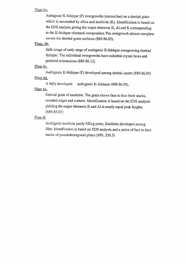

rllnñ.rr11l fì'f. rflr-È I- I llu L
l.( +tlu.
:r
6a

99.4Vo mole of KAlSi3Os. This clearly shows a similarity to the theoretical
composition of the end member of poussium feldspar (Kastner, 197l; Waugh, 1978).
5.3.2.5. FORMATION OF AUTHIGENIC FELDSPAR
Authigenic feldspar is related to the hydrolysis of unstable detrital grains within the
stability series of Goldich (1938), in which the solution of ferromagnesian minerals,
plagioclase and volcanic rock fragments resulting from non-equilibrium with interstitial
water, provides sufficient silica, aluminium and potassium, and can lead to the
formation of authigenic feldspar. This type of occurrence was attributed by Kastner
and Siever (1919) to the influence of volcaniclastic materials in the sediment. Scanning
elecron microscopy shows that hydrolysis has also affected minerals higher in the
stabitity series. Dissolution of K-feldspar and the precipitation of pore-filling minerals
(kaolinite, illite/smectite, zeolite) indicate that interstitial pore water has played an
important role in diagenesis
Authigenic potassium feldspar from this sedimentary sequence of the basin has not
previously been described in the a¡ea studied. The formation of authigenic feldspar in
the Jurassic-Cretaceous sediment conforms to the kinetic model of chemically
interrelated minerals in sedimentary environments proposed by Helgeson et al. (1969)
(Fig. s.2).
GIBBSIIE
loq oH. s,o.
Fig.5.2,activity diagram for the system K2O-AÌ2O3-SiO2-H2O at 0'C,unit,octivit¡'of wator, and ono atmosphere. Tho ehuded areas ìal¡eled M and A represont tlrocomposiüionel range of srlrfêce and decp ocean \r'atÆrs, respectively, and thost'annoüatod N and B deaignate, respecbisely, t,tre auerage composition of u'orltlstroa,ma and the compositional rangc of intcretitial u'oters in docp seo and ehslfe€dimonte-seo text. In addiùion to thc daüa cited in tho captiori of Fig' 2, heatcapacities taken from Cnrss and Cos¡Lr (106{), K¡r,r.n¡- (1960, 1962), andP,rxrn,rrz (1961) were used to colculate t,hc positione of tho stabilit,y 6cld bound-oriea. Estirnatod hoat capacities of tho ione ond H.SiOn at 0'C u'ero used in thecalculaüione. Tho mothode and unce¡taintiee involvotl in caìculating oquilibriunrconelanùs for this ßysLem (and ühose reprcscnüed in Figs. l0 and ll) at, tempora-turee other than 25"C havo bscn discuseed clgowhcro (G.ttrnrr,s and Clrt¡sr, 1965;
Ìfnr,orsox, l9B7b, 1960).
I€oo
X- F ELDSPAR
-6
2
NO
5
I
-3 -2
I
ii ÁMoRPHoUSI srt tcaI sÂTuRÄlroN
iu
31

TABLE.5 Comparision authigenic K-feldspar from the Bromanga Basin
wí th tlorld ni de authi genÍ c K-f eldspar
1 5432
si 02
At 203
Na2O
R20
TotaL
64.75
18. 32
16. 93
1 00. 00
64. 41
18.54
16.94
99.89
6¿. 90
18. 45
0. 10
16. 90
1 00. 35
66. 14
18. 46
14. 95
99. 5s
67. 57
'17. 90
o. 17
14.29
100. 14
1 The Bromsgrove Sandstone, TFiassic, central of England Ali and
Turner ( I 982)
Haugh ( I 978)
The Trenton Formation, Ordovician, GIenfall, NewYork, U.S.A.
( Kastner, 1971,
Cadna-owie Formation, Toodla {}1, Oodnadatta Formation
Trinity HeIl Sandstone, Trinity HeIl., cêntral north of South
Austral.ia
2
3
4
5

This model is confirmed in the diagenetic literature and particularly as regards the
formation of authigenic feldspar. From this model we can see that formaúon of
authigenic feldspar results from the relation between the K+ and IIaSiOa ratio. The
higher the FIaSiOa concentration, the gleatil the rate of precipitation of K-feldspar.
The purity and well-developed crystal faces of authigenic feldspar lead to the
suggestion that precipitation rates were slow, but with a consistent supply of element
sources.
Kastner and Siever (1979) proposed that authigenic feldspar forms in the early stage
of diagenesis. However, the occurrence of authigenic feldspar in the Bulldog Shale
clearly indicates that the minerals rwere precipitated during and following the
cementation of the rock (authigenic feldspar contains calcite inclusions and calcite
cement has also been overlapped by authigenic microcline ) and at the same time or
after the authigenic clays had developed in clastic sediments (authigenic feldspar
displays overgrowths on illite/smectite). Authigenic feldspar filling secondary pore
spaces indicates formation during a late phase of diagenesis.
5.3.3. Kaolinite
5.3.3.1. INTRODUCTION
Kaolinite in the Jurassic-Cretaceous sediments is a characteristic product of
diagenetic processes. It is an ubiquitous feature in the Algebuckina Sandstone and at
the base of the Cadna-owie Formation (Wopfner g! al, 1970, Exon and Senior, I976).
Most of authigenic kaolinite in the Algebuckina Sandstone sequences shows a high
degree of crystallization. Kaolinite often fills primary pore spaces, or secondary pore
spaces created as a result of hydrolysis and dissolution of the unstable minerals. The
presence of authigenic kaolinite indicates acidic and oxidizing conditions in the late
Jurassic sequence and the early Neocomian surface weathering of telogenetic regime
5.3.3.2. OCCURRENCE OF KAOLINITE
Kaolinite consists of detrital and authigenic components. At low magnification
detrital kaolinite often has rounded edges and corners. However, at high magnification
detital kaolinite shows ttre face-to-face book stack of pseudohexagonal crystals (Plate
6e). Detrital components ile rarely found and occur only in residual non-carbonate
outcrop samples of the Cadna-owie Formation. The detrital kaolinite grains are silt-
sized and display rounded edges and corners.
32
The authigenic component shows infilled pore spaces and secondary pore
spaces.and commonly replaces other minerals, such as illite/smectite and feldspar. The
authigenic component consists of a series of face-to-face stacks of pseudohexagonal
plates (Plate 6Ð. This also yields characteristics of the kaolinite spectrum under the
energy dispersive system (EDS) which have equal peak heights of silica and
aluminium corresponding to the chemical composition of kaolinite
Ala[SiaOls](OHro). They also have similar chemical compositions to Stuart Creek
Opal Field kaolinites.
However, kaolinite from the Algebuckina Sandstone Toola #1 and Trinity rü/ell
Sandstone reflects a higher degree of crystallization than weathered kaolinite of the
Bulldog Shale in the Stuart Creek Opal Field. The morphology and EDS spectrum of
authigenic components are also characteristic of a typical kaolinite mineral (Plate 7a,
7b) (Wilson and Pittman, 1977).
5.3.3.3. CHEMISTRY
Chemical analyses of kaolinite were performed on the electron microprobe. The
electron microprobe analyses give detailed indications of kaolinite chemical
composition, and are shown in Appendix 2. From these results (table 6.) we can see
that the chemistry of kaolinite from the Algebuckina Sandstone in Toodla #1 and the
Trinity Well Sandstone are similar to kaolinite from worldwide occurences described in
the literature. The electron microprobe analyses also yield a low elemental total (about
SlVo). This can be explained by the presence of 2H2O ,(OH) ions in the structural
formula of kaolinite or perhaps by an interlayer of water.
The chemical composition of kaolinite in the Algebuckina Sandstone (appendix 2)
shows very little variation. Analyses show very few substitutions in the chemical
composition. Deer et al., (1966) suggested that the formula of kaolinite can be written
in terms of oxides such as A12O3.2SiO2.2H2O. This composition is also similar to
halloysite (AlzO¡.2SiC,2 4H2O) bur, X-ray diffraction studies confirmed the crystal
srructure of kaolinite. On the X-ray diffractogram of the bulk samples, kaolinite (3T)
was identified by two major peaks at7.lgl. and 3.58Å (according to JCPDS). These
peaks collapse and become non-crystalline when heated to 550-6000C for about one
hour. However, X-ray diffraction of the 2 pm fraction shows a stronger intensity of
kaolinite peaks (a higher degree of crystallization). Thus, there is higher
proportion of ,kaolinit e (607o) in the clay fractions (Wilson and Pittman, l97l).
Kaolinite in the Algebuckina Sandstone and the lower part of the Cadna-owie
Formation from Toodla #1 is dominated by kaolinite type 3T.
33

Tabl.e 6. Chemical Comparigon of I(aolinite
wifh occunenc€ of kaoLlnite world
from the Eromanga Baein
wi de.
42I 3
si 02
A1203
Ti 02
FeO
Fe203
t{sO
l{nO
CaO
Na2 O
R20
H20
Tot aI
45. 80
39.55
0. 18
0. 57
0. 14
o. 28
59. 26
23. 50
0. 63
1.71
0. 86
o. o1
0. 15
l. 0s
t 3. 98
10t. 43
49. 01
30. 91
o. 50
o. 29
o. 28
o. 12
81. 11
¿6.5
39. 5
14. 0
1 00. 00
0
14
100
o3
09
77
1. Hydrothermal. kaolinite from Niigata, Japan ( Nagasawa, I 953. Quoted
from Deer et al. ( 1 966) ) .
2, RaoLinite from early etage of hydrothermally-altered granite
(ìlewnier and Velde, 1982).
3. 889.86.12, Trinity HeIl Sandstone, Trinity lleLl, cêntre north of
South Auetralia.
4. Dana 'I llanual of mineralogy. Cornelius S. HurLbut, JR. ( 1956)


t
a
-
3
a
à^ t .,
ÍÐf
\
i.r.
,tatq
-r^'-' '-ì- 1'.\
/
7e

Authigenic kaolinite is the principal clay in the Trinity V/ell Sandstone and was
possibly formed during diagenesis. The kaolinite was identified by powder X-ray
diffraction and has similar characteristics to the Stuart Creek kaolinite. However,
under the SEM, kaolinite appeared as euhedral crystals of an authigenic origin often
filling secondary pore spaces (dissolution porosity), as the result of hydrolysis and
dissolution of feldspar. (Plate.7c, 7d).
5.3.3.4. FORMATION OF KAOLINITE
Kaolinite forms under low temperature; low pH; high Etr and low alkali conditions
(Marshall, 1977). The degree of crystallization of kaolinite is increased by the presence
of iron in the system, hence the crystallization is related to the ferric minerals (Hurt
and Kunkle, 1985). The formation of kaolinite in the rock leads to the suggestion of a
fluvial type of environment within an oxygenated environment (according to Hurt and
Kunkle, 1985).
Formation of authigenic kaolinite follows the kinetic model of authigenic minerals
in sedimentary environments (Helgeson et al., 1969). In burial conditions, the water
pressure and concentration of tIaSiOa requisite for kaolinite are maintained, leading to
the precipitation of kaolinite. On the other hand, kaolinite tends to be transformed into
illite/smectite and other minerals under high pHand alkaline conditions.
The presence of kaolinite reflects the early Neocomian fluvial environment (Exon
and Senior , 1976 Griffith, 1979) and the weathering conditions of the Tertiary arid-
semi-arid climate of the central north of South Australia ('Wopfner, 1974). The
kaolinite consists of both detrital and authigenic components.
In surface weathering, dissolution of unstable minerals also contributes to the
formation of kaolinite. Barker (1983) showed that the formation of kaolinite in the
Andamooka and Coober Pedy Opal Field results from leaching of alkalis and alkali
earths under surface conditions and also leads to the transformation of smectite/illite
and other phyllosilicates to kaolinite..
5.3.4. Smectite/illite
5.3.4.I.INTRODUCTION
The most abundant clays in the upper part of the Cadna-owie Formation and the
Bulldog Shale are authigenic smectite and illite and allogenic mixed-layer illite/smectite
(I/S) series. The clays become rare in the bottom part of the sequence (Fig.5.1)
34

Crystal morphologies and chemical composition of the clays are similar to those
from clays described in several places in the world. Authigenic illite and smectite are
the predominant clays in the silty-sandy layers and in bioturbated zones of the Cadna-
owie Formation.and the Bulldog Shale
5.3.4.2. OCCURRENCE OF SMECTITE/]LLITE
Authigenic smectite and illite (allogenic mixed layer VS) are mainly recognized in
the marine trangressive sequences of the southern Eromanga Basin. Scanning electron
microscopy of the lower unit of the Bulldog Shale in Toodla #I at 234.7 5m depth
(I/S morphology in interbedded silts and shale) showed that allogenic VS is
predominant in the shale layers while authigenic smectite and illite dominate in the silty
layers and are strongly developed as pore linings and pore fillings These probably are a
result of variable compaction between shale and silt-sandstone.
Moreover, in some bioturbated layers there are other forms of detrital illite or
biogenic pellets (fecal pellets). In hand qpecimens, they have a green color indicative of
glauconite. They also have the spectrum and show the illite morphology under the
SEM (Plate 7e, 7f). This evidence indicates a transitional phase from illite to
glauconite. The burrows are also f,rlled with pyrite framboids.
5.3.4.3. CI{EMISTRY AND MORPHOLOGY OF SMECTITE/ILLITE
The smectite/illite mixed-layer clay mineral is represented in the powder X-ray
diffraction of clay fractions. The illite is identified by a small sharp peak at 10.05Å,
and is more abundant in core samples in both the 2 ltm fraction and whole rock
analyses than in outcrop samples. This possibly results from burial conditions.
Smectite is identified by 15.5Å-17.LÅ peaks and referred to as 17,Â..
Allogenic smectite/illite occurs with a flaky morphology. It often has a preferred
orientation and lies parallel with the silty layers. However, bioturbation has changed
the fabric of some shales (Plate 8a). The study of Bulldog Shale samples shows that
increasing potassium content and flaky VS lead to decreasing proportions of
expandable layers. The allogenic clays in the sediment of the ma¡ine trangression have
mixed layers ranging from 65-45Vo expandable layers.
The authigenic smectite in the Bulldog Shale has cellular, oakleaf and cornflake
morphologies. Individual crystals of smectite cannot be resolved under the SEM. They
appear as a thin honeycomb crust on detrital sand grains or growths outward from the
grains in pore linings (Plate 8b). Auttrigenic illite occurs mainly as pore linings within
silty layers. It has scallop morphology and curled edges. Its size ranges from 2-8 pm,
35

and it often aggregates with pyrite framboids (Plate 8c). Authigenic smectite and illite
have a high degree of purity (i.e. 80-907o of smectite, S0-90Vo of illite¡ (Plate 8d).
Semiquantitative analysis of the authigenic smectite yielded major elements
corresponding to the composition of Na-Ca smectite (1/2Ca,Na)0.2 (Al,Mg,Fe)
(Si,Al)8O20 (OÐa nH2O, while illite shows a true potassium-illite member (Plate 8e)
similar to that described by Welton (1984).
5.3.4.4. FORMATION OF SMECTTTEÄLLITE
The allogenic VS in the Early Cretaceous sequence is clearly from the pre-
Mesozoic Basement and also indicates volcanic sources' study of vs has shown the
low to moderate iron content in smectite possibly reflects an andesitic or felsic volcanic clastic
In addition, VS is associated with chemically immature sediments of the Aptian and Albian. This
suggests the sequences ,ü/ere either rapidly buried in marine conditions or
accummulated under extremely unfavourable climates for chemical weathering, such as
cold or arid conditions.
Conversion of smectite to illite is well known as illitization (Perry and Hower,
1970; Keller et al.. 1937). The process of illitization in the Jurassic-Cretaceous
sediments in the southern Eromanga Basin possibly relates to the dissolution, K-
fixation and morphological conversion of smectite. Other factors are illitization,
pressure, temperature and burial history. The illitization from smectite releases a large
amount of intergrain water by the dissolution of smectite. The water may carry a large
quantity of material leading to the formation of oil, gas and authigenic minerals (Burley
et aI.,1987).
5.3.5. Zeolite
5.3.5.1. INTRODUCTION
Clinoptilolite is the dominant mineral of the zeolite facies in the Cretaceous
sediments. It commonly replaces detrital plagioclase or infills pore space. Zeolite in
several places throughout the world is associated with volcanic activity, and it is also
considered as an authigenic mineral in sandstone and shale (Kastner and Siever,
1979). Clinoptilolite and several other zeolite minerals in the Cadna-owie Formation
and Bulldog Shale are possibly representative of the alteration of volcanic clastics in
the Cretaceous sediments. Also, Ca-clinoptilolite can be related to the dissolution of
plagioclase in the rocks. The mineralogy of zeolite in the Cretaceous sediments in the
southern Eromanga Basin is similar to several other zeolite occurrences in silicic
36


.s.l
!; ?¡r'l,È*
8a 8b
.4./1.t
8c
3Ø uø2ØØkV 885E2 ø 153/ø2 ñUlt'lU
I l¡Jñ-r.il'r {7it I tla? ' h' HrìlP IL

volcanic and volcaniclastic rocks worldwide (Jeans, 1978,1982; Jones and Fritzerald,
1987).
5.3.5.2. OCCURRENCE OF ZE:OLITE
Zeolite is a ubiquitous feature in the shaley layers of the upper part of the Cadna-
owie Formation and the Bulldog Shale in the southern Eromanga Basin.
(Norton,1983). The most common occurence of authigenic clinoptilolite was as the
euhedral crystal shapes, and lining of pore spaces or pore filling in silty layers of the
Bulldog Shale (Ptate 81 9a). At high magnification clinoptilolite crystals are
tabular or coffin-shaped. Some individual crystals have dimensions of about 1x5x20
pm.(Plate 9c). They are aggregated among authigenic K-feldspar crystals and a¡e
usually coated with a thin layer of authigenic smectite/illite. With this combination,
identification of the morphology of the two minerals is often difficult. However, EDS
analyses show that authigenic K-feldspar is a pure end member of K-feldspar and
yields the major elements potassium, silica and aluminum. On the other hand,
clinoptilolite contains all the major elements, such as sodium, silica, aluminium,
calcium and potassium, with the addition of iron and magnesium coming from the
clay coatings (Plate 9d).
5.3.5.3.CHEMISTRY
The identification of clinoptilolite is based on the morphology and semiquantitative
analysis by EDS and X-ray diffraction. However, application of X-ray diffraction
techniques was difficult due to the small proportion of clinoptiloliteand the overlapping
of peaks from other minerals. Hence, SEM and electron microprobe were the major
techniques used in the study. Chemical composition of various zeolites are shown in
appendix 2. From this result we can see that the dominant component of zeolite is
clinoptilolite.
5.3.5.4. FORMATION OF ÆOLTTE
The presence of clinoptilolite in the Jurassic-Cretaceous sediments of the southern
Eromanga Basin possibly indicates a volcaniclastic origin for the source rock, even
though the genesis of zeolite is the result of Gawler Ranges volcanic alteration. It is not
apparently associated geographically with the regional sources. Norton (1983) reported
an abundance of volcanic fragments in the Cadna-owie Formation and the Bulldog
Shale (foodla #1). Volcaniclastic material is relatively unstable at the earth's surface.
37
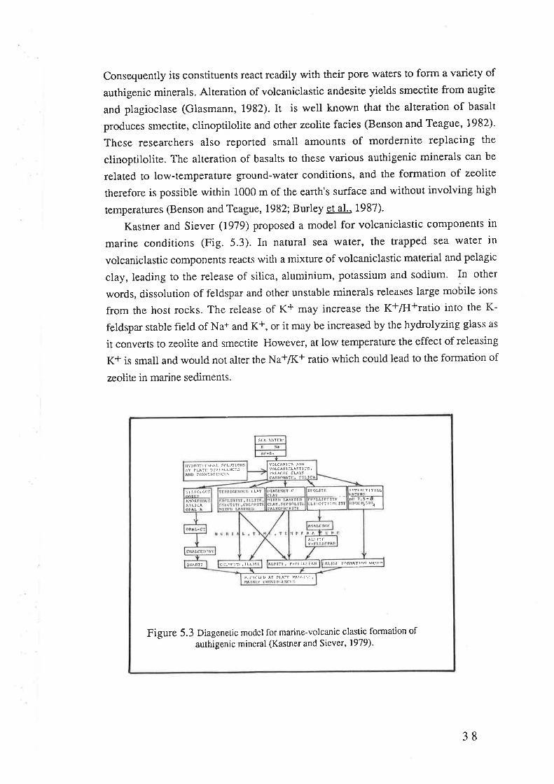
Consequently its constituents react readily with their pore waters to form a variety of
authigenic minerals. Alteration of volcaniclastic andesite yields smectite from augite
and plagioclase (Glasmann, 1982). It is well known that the alteration of basalt
produces smectito, clinoptilolite and other zeolite facies (Benson and Teague, 1982).
These researchers also reported small amounts of mordernite replacing the
clinoptilolite. The alteration of basalts to these various authigenic minerals can be
related to low-temperature ground-water conditions, and the formation of zeolite
therefore is possible within 1000 m of the earth's surface and without involving high
temperatures (Benson and Teague,1982; Burley et al.. 1987).
Kastner and Siever (1979) proposed a model for volcaniclastic components in
marine conditions (Fig. 5.3). In natural sea \ryater, the trapped sea water in
volcaniclastic components reacts with a mixture of volcaniclastic material and pelagic
clay, leading to the release of silica, aluminium, potassium and sodium. In other
words, dissolution of feldspar and other unstable minerals releases large mobile ions
from the host rocks. The release of K+ may increase the K+ÆI+ratio into the K-
feldspar stable field of Na+ and K*, or it may be increased by the hydrolyzing glass as
it converts to zeolite and smectite However, at low temperature the effect of releasing
K+ is small and would not alter the Na+Æ(+ ratio which could lead to the formation of
zeolite in marine sediments.
t¡ c\(Lr u ^T
Pl ^Ìl
!Àlc¡'.:
ou^nt: f TLL ÂTcr¡I,ônt îli . Ì LLI Tl lt tntrq^Î1nil ßÀTl:P
st LlcA 41
5¡LlCl:OlS IC tìît:na1r1 tÀL
cohat¡GlNcl s
ilYDnfr tlt lohl, s(,LUlloN5
^1 IBlt: Dl\"fìCl:rcf,s volcaillcLÀsf 1 cs,
¡tJlGrc cuts
FigUre 5.3 Diageneric model for marine-volcanic clastic formation ofauthigenic mineral (Kastner and Siever, 1979).
38

Thus, the presence of zeolite in the Cadna-owie Formation and the Bulldog Shale
means that there is proportionally less authigenic K-feldspar in marine volcaniclastic
conditions. The critical factors of conversion of these minerals are not known.
However, in sediments older than about 200 my., zeolites and smectites are rarely
found as the result of further alteration to an illite-chlorite-feldspar assemblage.
5.3.6. Glendonite
5.3.6.1. INTRODUCTION
Glendonite belongs to a group of calcite pseudomorphs of ikaite and is regarded as
a syngenetically-formed mineral from organic rich muds at sub-zero temperature within
high latitudes or polar environments, such as Greenland and Antarctica (Danish, 1963;
Kemper and Schmitz,1975,1981; Suess et al.. 1982: Kemper, 1987).
The occurence of glendonite within the Cadna-owie Formation and the Bulldog
Shale led to a detailed study being caried out as part of this pdect; the results support
the palaeoenviromental reconstruction of Fennessy (1984). The occurrence of
glendonite indicates a cold climate similar to the polar arctic region (Canada, Siberia).
It is necessary to describe the glendonite mineral, which is suitable for evidence as a
thermometer in geological history.
5.3.6.2. PREVIOUS STUDIES
David (1905) described glendonite as a pseudomorph mineral occuring in Permian
glacial sediments and possibly the Cretaceous ice rafted unit in New South Wales. However
the original mineral was known as glauberite.
In 1963, Pauly discovered that ikaite was the original mineral of glendonite, when
he found ikaite at the surface at low tide in the waters of Ika Fjord, Greenland. The
samples rapidly disintegrated under wafiner conditions. Pauly believed ikaite was
formed by bicarbonate springs at the bottom of Ika Fjord.
Brook et al., (1980) described ikaite as a low temperature calcium carbonate
mineral, but it is unstable and at normal temperature becomes calcite and water. Brook
et al also suggested that ikaite might have widespread occurence in polar ma¡ine and
high latitude cold-water regions.
Suess et al., (1932) found ikaite on the sea bottom at sub-zero temperatures in
Antarctica. They described crystallization of the mineral as monoclinic-symmetrical
crystals which disintegrate rapidly under surface conditions. Stein and Smith (quoted
by Shearman and Smith, 1935) found ikaite in the sediment of the Nankai Trough in
39


øzø9,ø4 496 Zlt)5Ø"n2ØØkt) 44ZE¿¿
^
-tl
i=:È'l-
Japan at a great depth under cold conditions, and also proposed a stable field of ikaite
under natural conditions. Kemper and Schmitz (1975, 1981) and Kemper (1987)
compared the results of palaeontological studies on glendonites of Cretaceous age in
Siberia and the Canadian Arctic Region. From an account of all known glendonites,
Kemper (1987) concluded that glendonite is the pseudomorph of calcite, and that glendonite can
be used as evidencè of a polar ma¡ine depositional environment, These workers thus
showed that glendonite is a geological thermometer.
5.3.6.3. OCCURRENCE OF GLENDONITE IN TI{E EROMANGA BASIN
Micro-siderite concretions occur in the Cadna-owie Formation (Toodla #1). These
have a similar morphology to the macroscopical-glendonite which appears in outcrop
samples near Coober Pedy. Powder X-ray diffraction studies of these glendonites
show that siderite and bassanite are the major pseudomorph minerals. Macroglendonite
shows very high crystallization in the X-ray diffractogram. Major peaks appear at6.02
Ã; 3.a7 Ã;3.00Å; 2.72Ã; 1.84Å. According to JCPDS these peaks are identified as
bassanite. However, this could be a result of the dehydration of gypsum under arid
conditions in the area. Thus, the original pseudomorph mineral is more likely to have
been gypsum than bassanite. In addition, dehydrating gypsum (CaSO¿) nH2O at
temperatures above 450C would give bassanite Ca2(SO4).nH2O (Rowe and Bigelow,
1972. Quote by JCPDS).
The most common appearance of microglendonite is as the polar euhedra
pyramidal and hedgehog crystals of siderite pseudomorph. Scanning electron
microscopy of samples from the Cadna-owie Formation (889.273.5) shows that most
of the detrital grains a¡e coated by microglendonite (Plate.9e,9f), ranging in size from
a few pm up to 30 pm. They occur as embedded crystals in fine-grained clay
sediments and parent crystals grew displacively. Hence the original mineral is
considered of authigenic origin and was possibly generated by reactions with
interstitial \'r'aters.
5.3.6.4. MORPHOLOGICAL STUDIES
Macroglendonite appears as "hedgehog" concretions on macroscopical studies.
They range in colour from white=brown to yellowish-grey and their sizes vary from
0.5 to 5 cm. They occur as spherical clusters. The teÍns pineapple" @avid et al.,
1905) "pola euhedra" and "hedgehog" (Kemper and Schmitz, 1975) were used as
genetic terms. The morphology of glendonite in the Creteceous sediments is also
similar to those described by Shearman and Smith (1985) as summarized in the
40

previous studies. Overall, individual crystals have a pyramidat-aPpearance which is
seen as asymmetry in the crystal shapes, and incline slightly in opposite directions.
The pyramidal crystals a¡e clearly recognizable in all the samples, and are roughened
by series of gypsum crystals. This is evidence of material in the pseudomorphous
crystalline discontinuity (David et al., 1905). Measurement of the angles between
pyramidal crystals give 950, 600, and 1250 respectively, suggesting a monoclinic
system for the macroglendonite.
Scanning electron microscopy gives the best microphotographic reproduction of
microglendonite. At high magnification, individual pyramidal shapes are recognizable
as elongated crystals, which are similar to those crystals described on the macro scale
by Shearman and Smith (1985) and Kemper (1987). The hedgehog form of many of
either pinacoids or prismatic faces (Plate lOa) occurs as in the macro scale. The
crystallised system does not correspond to that of the trigonal class of symmetry, but
either the tetragonal or the orthorhombic system. Some of the individual pinacoidal
crystals have crossing angles which might indicate the presence of either twinning or
parallel intergrowths (Plate. 10b).
5.3.6.5. FORMATION OF GLENDONITE
Glendonite (pseudomorph of ikaite) has been described as a syngenetic shallow
epicontinental sea mineral, and the presence of glendonite appears to be a reliable
indicator of low temperature (00C or less)-
Glendonite is often accompanied by glaciomarine sediments, which were
widespread during the Cretaceous in the Arctic regions (Kemper, 1987). However,
Shearman and Smith (1985) believed that ikaite was formed under cold conditions at
geat depth.
Marland (1975) experimentallY
studied the stability of ikaite facies and
proposed the stability field relations of
ikaite with respect to temperature and
pressure (Fig.5.a). During diagenesis,
a change from the originalenvironment would cause raPid
dehydration and conversion of
monoclinic ikaite tocalcite. This was considered as the
process of formation of glendonite
pseudomorphs (Suess et al., 1982).
{thorho
Corcl
ac ìl'anaco¡¡ll¡
C ALC ITE(C a Co'l
(Hexagonal /Trigonall
IK AITE. (CaCo.6H2O)
( Monoclinic )
-10 0 10TemPeraltrre ('C)
Figure 5.4 SraUtity rclations of ikaite with
respect to prcssure and tem¡rcraturc
(Aftcr Marland, 1975).
2
4
ÀYq)
:t-ø5qo)
(L
4t


.t(,1
t.. ,t:
3Ia
l
I
.:4'rlg(y
I f 'hri'ì I
e0I
Furthermore glendonite occurs in Cretaceous sediments of the southern Eromanga
Basin within a probable depth range of 50 to 200 metres (chapter 2). The presence of
glendonite in the Cretaceous sediments is good evidence of a polar cold climate during
at least some parts of the cretaceous.
5.3.7. Pyrite
5.3.7 .1. INTRODUCTION
Sedimentary pyrite is characteristic of authigenic minerals in anoxic muds and
sulphate-reducing conditions. It is widespread in the Cretaceous marine-trangressive
sequences of the Eromanga Basin. Pyrite normally forms during early diagenesis and it
is one of the best known authigenic minerals (Berner, 1981).
5.3.7 .2. OCCURRENCE OF PYRITE
In hand specimens and thin sections, pyrite occurs as a thin, black mass adjacent
to detrital quartz or clays. Pyrite-infilled worm burrows from the Bulldog Shale and
the upper part of the Cadna-owie Formation sediments were examined by X-ray
diffraction. On the X-ray diffractogram, the d-spacings of 3.13Å, 2.70Ã,2.21Ä' and
1.9lÅ.were identified as pyrite (JCPDS). However, scanning electron microscopy
shows that smectite/illite occ¡rs together with pyrite crystals. The pyrite occurs either
as framboids or single euhedral crystals. Pyrite framboids are round, occasionally
oval-shaped and often infill worm burrows. Pyrite framboid aggregates are composed
of small, closely-packed octahedral crystals. Small euhedral forms of
pseudooctahedral pyrite are also randofnly distributed through the rock. In addition,
large pseudooctahedral pyrite crystals are sometime aligned, possibly replacing rvorrn
tube burrows. Their size ranges from a few pm to 15 pm (Plate 10c, 10d). At high
magnification, pyrite framboids consist of a cluster of many small individual
pseudooctahedral pyrite crystals (Plate 10e). The euhedral crystal faces of octahedral
pyrite show its authigenic origin. In most outcrop samples, the pyrite shows highly
weathered surfaces, corroded into crystal shapes (surface oxidation of telogenesis).and
yields iron oxide traces (possibly goethite) under the EDS (Plate 10Ð
42

5.3.7.3. FORMATION OF PYRITE
Formation of pyrite is well known as originating in the reaction between H2S from
bacterial sulphate reduction and reactive detrital iron minerals (Bernet, 1964' 1970,
l9l2; Goldhaber and Kaplan, 1914).
The amount of pyrite
formed in a sediment depends
on three factors (Fig. 5.5).
These are, the availability òf
dis solved sulfate, the
concentration of organic
matter which can be
metabolized by sulfate
reducing bacteria, and the
concenüation of iron minerals
in the environment. These
three factors vary from fresh
water to marine and brackish
water environments.In fresh
water conditions, formation
of pyrite is limited by low
concentration of dissolved
sulphate.
In addition, oxidation of organic matter in the fresh water environments tends to
inhibit the precipitation of pynte. However, in rrormal marine conditions, formation of
pyrite is also limited by the amount and reactivity of organic debris buried in sediment.
The reaction berween pyrite and organic debris is considerable. This reaction may
partly disolve pyrite, leading to the formation of minor pyrite framboids in the
laminated black shale facies. But, in anoxic marine conditions (brackish lagoonal
facies, etc.) the precipitation of pyrite is greatly enhanced by a plentiful supply of
organic debris and H2S plus the abundance of iron minerals (smcctite, glauconite.)
brought to the site of pyrite deposition.
Nevertheless, brackish water sediment represents an intermediate situation
between fresh water and marine environments If the water is insufficiently saline,
sulfate will be dissolved. The result is that siderite has a high probability of forming
(Berner, l98l). Bemer (1g74)reported formation of siderite in the Baltic Sea similar
to the described environment during the last glaciation. Thus, the occurence of pyrite is
Fe52PY R ITE
Figure 5.5: Sehematic diagram of tlre pathway of
f.he formation pyrite in marine envi¡onment
(After Berner,1972).
FeS
ro
o
HzS
43

evidence of sea level change during the Cretaceous in the southern Eromanga Basin
(from fresh water to marine and brackish environment).
5.3.8. Glauconite
5.3.8.1. INTRODUCTION
Glauconite is common throughout the upper part of the Cadna-owie Formation and
in the Bulldog Shale. The term glauconite as used here, was defined by Millot (1970)
as "a variable mixture of mínerals in which illite, montmorillonite, chlorite or varíous
mixed layer cløys can be dcfined.The total aspect remains that of green clay mínerals,
but it is not known whether one part or another yet merits the name glauconíae".pp
205. The Occurrence of glauconite has been used both as a strati$aphic tool and as an
indicator of depositional en'üironment.
5.3.8.2. OCCURRENCE AND CI{EMISTRY OF GLAUCONITE
Glauconite is abundant in the marine sequence of the Cadna-owie Formation and
Bulldog Shale (sample 889.189.5 contains up to30Vo glauconite). The first glauconite
was recorded at a depth of 258.5m in the core and becomes more abundant in the
Bulldog Shale and Oodnadatta Formation.
Glauconite in the Cretaceous sediments can be grouped into two components (a)
those which are biogenic or fecal pellet and (b) those which have the morphology of
detrital illite/smectite (glauconitic illite). Fecal pellet is the common type found in
outcrops samples and in some areas can make up to 20Vo of the sediment. They are
generally of medium sand size, and are considered as palaeontological evidence of
marine or paralic environments @xon and Senior,1976).
Powder X-ray diffraction results (chapter 3) show peaks at 10Ä and 16Å after
glycolation, indicating a clay with highly variable hydration properties. Under the
SEM, glauconite shows two types of morphologies: fecal pellets and detrital illite. Athigh magnification, the fecal pellets show very well rounded, polished surfaces and
yield a glauconite spectrum under EDS. Detrital illite also seems to occur as well
rounded particles. But at high magnification it appears flaky, or cornflake-like, which
is typical of the detrital illite morphologies series, and yields a glauconite spectrum
under the EDS (Plate 1la, 1lb). However, X-ray diffraction of both types does not
show the peaks for glauconite (only smectite/illite/). Thus, glauconite in these
Cretaceous sediments is crystallographically poorly defined. Chemical analyses ofglauconite (table 7 and appendix 2) shows that glauconite from the trangressive marine
44

lABLE 7 Comparision Bulldog Shale glauconite with world-wide
glauconi te
42 3I
si 02
Ti 02
A1203
Fe203
FeO
Hso
CaO
Na2 O
I(2 0
H20
Tot a1:
49.
0.
3.
21 .
3.
3_
0.
0.
6.
11.
't 00.
20
12
17
73
19
85
74
12
o2
81
03
53.24
0.45
18. 82
13.30
2. 62
o. 79
5. 11
53.61
0_ 19
5. 44
29.03
0. 23
0.54
2. 65
53.86
0.34
12. 41
16.86
3.07
1. t6
0.64
5.06
1. Deer et aI. ( I 966)
2. Norton (1983)
3. .Bornhold and Giresse
4. Bulldog Sha1e, ToodIa
Australia
94. 33 91. 69 93.22
( 1985)
{}1, Oodnadatta, central north of South

sequence of the Mesozoic sediments lies in-benveen a true glauconite and illite @eer et
al., 1966).
5.3.8.3. FORMATON OF GLAUCONITE
These results suggest that the glauconite from the Bulldog Shale of the Eromanga
Basin consists of detrital mixed-layer illite/smectite, which possibly came from the
basement rocks. The occurrence of similar types of glauconite is also reported by
Hower (1961) and Bornhold and Giresse (1985).
5.3.9. Gypsum
5.3.9.1. INTRODUCTION
Secondary gypsum is a dominant feature in the studied area. It only appears in
surface and outcrop samples, and has been well described by many workers such as
Jones and Segnit (1966); Nicol (1979) and Barker (1983).
5.3.9.2. OCCURRENCE OF GYPSUM
There is widespread occurrence of gypsum in a large area of central-north South
Australia. Scanning electron microscopy has shown that gypsum crystals infill pore
spaces, replace clay minerals and have euhedral shapes.
Powder X-ray diffraction of gypsified silty-shale samples (Marree Formation)
yields major peaks at about 7.58Å, 4.25Ã,.These peaks indicate the presence of well
crystallised gypsum. Under the SEM, gypsum shows a fibrous appearance in the form
of patchy rosettes or fan shapes. These are formed by long prismatic lath-shaped
crystals ranging from 5 to 20 pm (Plate 11c, 11d). Moreover, supplementary
identification by EDS yields calcium and sulfur of nearly equal peak heights. These
peaks correspond to the chemical composition of gypsum (CaSO/.
5.3.9.4. FORMATON OF GYPSUM
Secondary gypsum of the Mesozoic sediments in the southern Eromanga Basin relates
to the weathering of pyrite-rich mudstone and limestone (Dr. J.B. Jones pers. coms.).
Ground water chemistry of the Coober Pedy region features very high concentrations
of calcium and sulphate (Barker, 1983).Gypsum infills pore spaces and secondary
pore spaces. It replaces wood fragments and overgtows most minerals in the samples.
45


ç .'...
/
lla
llc
t
lld
/,
I3 t¡2ØØkU lø583 øØø2 ' ø2 SE /SE 2
fi,-
lle

Thus, the occurrence of gypsum is as a secondary mineral rather than a syngenetic
form, and clearly represents a product of the telogenetic regime.
Garrels and Lerman (1981) proposed a genesis model for sulfide species and
considered that weathering of sedimentary pyrite and CaSOa, contributed to the ocean
reservoir. The ocean forms the same minerals. The redox imbalance resulting from a
net shift of sulphur between the CaSOa and pyrite reservoirs is taken care of by
concurïent shifts between organic ca¡bon and calcium carbonate reservoirs. This can
be chemically expressed by the reaction:
15H2O + 8CaSOa +2Fe2O3 + TMgSiO3 =-4FeSz
+ 8CaCO3 + 7MgCO3 + 7 SiO2+
15H2O.
From the reverse equation, we can see that the oxidation of pyrite and calcium
carbonate leads to the formation of gypsum in the studied area. The reaction is known
as the processes of sulphur/sulphate reaction (Berner, 1984).
5.3.10. Minor components
The minor components consist of derital apatite, detrital ilmenite and micas. The
minor components were mainly identifred by EDS under the SEM (Plate lle,ltf,l2a,l2b,I2c,12d). Both ilmenite and apatite show variable sizes, shape and degree of
rounding. Mica is dominated by muscovite, but biotite was also recorded in shale
facies at a depth of 258m . Although these minerals occur in small numbers and have
been little affected in the sedimentation, their occrurence provides more evidence about
the depositional environment.
Powder X-ray diffraction analyses of bulk samples from the Stuart Creek Opal
Diggings also indicate that muscovite is abundant in the Marree Formation. It is
identified by srrong peaks atg.g7 Ã, 4.g4Ã, 4.45Ã,334Ã,2.55Ä., 2.29Ä (according
to JCPDS). Under the SEM muscovite has mainly angular shapes. Individual cleavage
plates of mica appear as flakes and the EDS spectrum contains major elements of
silica, aluminium, potassium and iron which correspond to the chemical composition
of muscovite K2Ala Si6A12O2g(OH,F)4 (Plate 12e).
Muscovite is the predominant mica in all samples from the Trinity Well Sandstone,
the Pelican V/ell Formation and the Marree Formation. Powder X-ray diffraction
analysis of the sand fractions from PIWN3 yielded well-defined muscovite peaks of
9.98Å (according to JCPDS). Scanning electron microscopy demonsEated that the
crystal morphology of biotite and muscovite are similar. Individual cleavage layers of
mica appear as flakes. It was possible to differentiate between biotite and muscovite
with the EDS. Biotite consists of silica, aluminium, potassium, magnesium, iron, and
titanium, whereas muscovite contains only a minor amount of iron and does not show
46


t2b
12d12c
l2e

magnesium in the spectrum (Welton, 1984). The muscovite is often overgrown by
other authigenic minerals (Plate 12f) such as potassium feldspar, illite and silica or
quartz. Calcareous-cemented-fine-grained sandstone (889.12) from the hummocky
cross stratified unit at Trinity Well shows detrital grains overgrown by authigenic
feldspar.
Siderite is identified by X-ray diffraction with peaks about 3.59Å, 2.79Ã,2344,,
2.13A,,1.96Å and 1.79Å. Under the SEM the siderite is represented as euhedral
crystals forming glendonite nodules (as mention earlier). Identification of these
minerals was made by the mettrods mentioned above.
5.4. DISCUSSION AND CONCLUSION
The Jurassic-Cretaceous sediments consist of two mineralogic assemblages and
cover a wide range of depositional facies. Furthermore, diagenetic features can be
distinguished from primary ones (Burley gEú., 1987).
The classical interpretation of the change from kaolinite to montmorillonite is
related to the change from fluvial to marine environments (\ilopfnorüL, 1970; Exon
and Senior,1976; Griffith, 1979). Weaver (1967) notes that a change from low to high
kaolinite content repfesents a change from a relatively more open sea to a near-shore
marine environment. However, Segall et al. (1988) detailed the study of clay mineral
indicators of geological subaerial modification near surface Tertiary sediments on the
northeastern Grand Banks of Newfoundland. This work has demonstrated that clay
mineralogy respones to sea level changes during geological time. Segall et al. noted
that fall in sea level led to the alteration of marine sediments (smectite) by acid leaching
to form a kaolinite enriched weathered zoîe; a,trangressive stage led to the reworking
and redeposition of early weathered zones.The clay mineral assemblage input by
glaciers from northern latitude provenances includes illite, chlorite, smectite and minor
components of kaolinite. These sediments are also associated with sands and gravels
from ice rafting. A model for the formation of the Jurassic Cretaceous sediments on the
southern margin of Eromanga Basin is suggested and summa¡ized in figure 5.6.
From this model, two chemical environments have been identified on the basis of
clay mineratogical analyses: a fluvial zone exemplifield by an acidic environment for
the Late Jurassic-Neocomian; and a marine shelf deposition zone indicated by an
alkaline environment during the deposition of the thick sequence of the upper part of
the Cadna-owie Formation and the Bulldog Shale.
Clay minerals from the Algebuckina have a kaolinite component, which is absent
in the overlying late Aptian-Albian. The high kaolinite concentrations are suggested to
47

Figure 5.6: Schematic section of basal facies relationships from the late Jurassic
to the Tertiary period of southern margin of the Eromanga Basin
FeHNO35
Ò
oo
s-
TF]LOGT]NETI C RIìG IM I.]
Regressive: TertiarY
(
L
Þ++{.t{+
sediments
rTerrapinaGranite
Mesozoic++++++++++{
Regressive
Transgressive: Neocomian-Aptian
++ +na Grani
++ ++ +'7
qtssediment
pre-U)
-7
-7
+++++++++++
Transgressive
I hecipirarcdI ron"Ir
gl Burial ana
!lciagenetic zone
AI I
[:xi';îï;4.L
-_-_3): -o-
G-e
Ca-e-a> FeN
(,)
oN
oCd
ÈO(l)kÈ
PAl NaCa Mg S
Regressive: late Jurassic
Mesozoicpre-
TerrapinaGìanit-e ++
++ +++./"
+++++
+++++
Regtessive
AIs
G)
oN
!ot<o)
q)
È
Leached zone
sFeCa
Eruiched-Alæred zone
. quartz
. feldspar
. kaolinire
)
c)
oN€í)¡<q)
CüG)
È
Leached zone(dissolution)
enriched z.oncHalite ßypsumsilica kaoliniæ
authigenicminerals
I)rainagc

have been formed from the alteration of Precambrian sediments. The Algebuckina
Sandstone sediments are clay-poor sands and gravels that were deposited during the
regressive event. Local differences in stratigraphy and sedimentary textures compared
with later marine strata from the area are also confirmed to bç of fluvial type,
subaerially exposed during the Late Jurassic.
In marine environments (Bulldog Shale), alkaline sea water gave little potential for
chemical reaction between the detrital mineral phases and normal marine pore water.
Hence minerals in both fine-and-coarse-grained sediments were affected only by
changes in pore water chemistry during initial burial or by reaction of the less stable
detritus, including ferromagnesian minerals and feldspars (Kastner and Siever,1979;
Ali and Turner, 1982).
Diagenesis in the marine Bulldog Shale probably commenced immediately
following deposition (Burley et a1., 1987), and probably at the sediment water
interface (Berner, 1931). At first, bacterial oxidation of organic matter released
bicarbonate ions into solution. Further, sulphate-reducing bacteria also liberated
bicarbonate ions into pore waters and continued to reduce pH by production of HzS.
Hydrolysis and dissolution of unstable minerals also occured at this stage. As a result,
authigenic minerals were rapidly formed near the sediment-water interface. Pyrite may
form after these reactions (Berner, I974) together with authigenic-mineral suites
including illite/smectite, chlorite, K-feldspar, quartz and zeolite (Kastner, l97l; Segall
et al., 1938). Thus, surface chemistry (eogenetic) of the Bulldog Shale diagenesis
conforms to a predictable pattern which is summarized in figure 5-7.
The feldspathic greywackes contain authigenic smectite, and illite formed either by
grain dissolution or directly from sea water (Elverhoi and Bjorlykke, 1978). The
precipitation is probably the result of an increase in the ionic concentration of the sea
water or the pore water as silica- and alumina-bearing solutions migrated from adjacent
(or underlying sequence) shales to combine with potassium from interstitial sea water
(Kastner and Siever, 1979). On the other hand, the breakdown of unstable detrital
mineral grains overode the subtler effects outlined above (Jones and Fiøgerald, 1987).
Silica, aluminium, sodium, calcium potassium and magnesium ions may be released
into solution during grain dissolution, leading to complex diagenesis in the marine
Bulldog Shale. Authigenic chlorite may be formed as a result of the above released
ions. But overall ttre VS tends to be precipiøted in preference to more illite. Glauconite
(detrital VS) may become more pot¿tssium-rich and evolve and mature until reaching an
end member which is chemically and mineralogically a potassium mica"
Following the initial stage of alteration in the depositional environment
(eogenesis), the rocks underwent further changes during diagenesis. This requires a
change in physicochemical conditions, including temperature, pressure and pore fluid
48

TIGURE 5,?. SCHEI|IATIC OF DIAGENETIC PATHWAIS
OF THE IïARINE DULLDOG SHALE
A}IOXICGROUND WATER
ICHLORITE XAOLINUE
QUARTZ O\ERGROI¡T}Ì8 QUARTZ & FELD8PAR O\¡ERGROI¡IIIT
OXYGENATEDGNOUND WATER
NON.FERROA}T CALCNE
IITTRODUCIIOX OT FONüÍAÎION YATET
FERROAN CALCITE A}TD CLAE
BRACKISHIITARINE PORE WATER
IllvlECTtTE
(rlrctirrlillirr colwrriol rcrirr)
INLLlTE
I
ZEOLITE, FELDEPAR & QUARTZ
SIDERNE OR NON-FERROA}T
CALCTIEsIDERIlE

chemistry under burial conditions (mesogenesis). Petrological study of the Jurassic-
Cretaceous sediments indicate that the principle change from the eogenetic to the
mesogenetic regime is a change from friable to slightly cemented and compacted
sediment.
Illite/smectite and
probably glauconite follow
the path shown in figure 5.8.
Illitization releases silica,
calcium, sodium, iron and
magnesium into the Pore
waters which maY be caPable
of transporting dissolved
ionic species from mud rock
into sandstone. Silica and
aluminium may be
precipitated as quartz
overgrowths and authigenic
kaolinite, whilst iron and
magnesium may contribute to
the formation of chlorite and
siderite.
Shale and silt, when initially deposited, have porosities in excess of 80Vo (Burst,
1969). Much of this porosity is lost during early burial and water is expelled by
mechanical compaction. Thus illitization and compaction led to water (carrying ionic
species) migrating upward under the pressure gradient and precipitating minerals at
higher levels in the section (Burst, 1969; Parson et al., 1982). Interbedded shale and
silt layers react in different ways. During compaction the orientation of clay particles in
shale changes from a random to an oriented direction which is parallel to basal
spacings. The spaces appear to have undergone intense compaction'
Znolite and I/S cements are the most common features in the shaley layers of the
upper part of the Cadna-owie Formarion and the Bulldog Shale. It is inferred that the
shaley facies have less permability due to large percentage of fine matrix which clogs
pores.The prevention of water movement or basinal compaction (buried condition of
Toodla #l) are important factors in the reduction of porosity of the Bulldog shale.
However, in the sand rich facies, pore fluids which moved through the sandstone pore
spaces precipitated calcite and siderite in acid to moderate pH condition. In alkaline
conditions (marine), smectite and illite freely infill pore spaces and secondary pore
spaces. Thus, smecrite and illite are the major porosity destroyers in these silty-sandy
49
F i g.5 .8 Schematic diagram showing lhe conversionof smectite to illite in burial conditions.Nore dashed curves represent the boundarybetween smectite and illite.(afrer Keller êr a1.,1987)
IEMPEFATURE
orssoLUttoN
ILLITEsMEcrrrE \,s-
Il x-FrxaTtoN
Þ.rl.cl t l(-tlr.dsHÉcltlE I sMEcfrfE
I
I
I
II
p.. I ac¡ILLITE
GROWTHIK.FIXATIONI
a9p¡aanIlyrñ1..¡lraltlr.d l/S
\\I
\PRECIPIfAIION \
\\\
rmñrluraIL L¡IE

marine sediments. The formation of matrix and compaction precluded the development
of cements that are common in the Mesozoic sediments of the southern Eromanga
Basin.
Rocks exposed at the surface suffer from weathering processes. Most minerals
formed under burial conditions (elevated temperature and pressure) become unstable in
oxidic and acidic conditions. Alteration first affects organic matter and organic matter
deposited under euxinic conditions during burial becomes oxidized and carbon is
removed from the rocks (Curtis, 1976). The Trinity Well Sandstone is a highly
permeable sandstone itself and meteoric water would have easily peneÍated into the
friable sediments. As a result, most of the organic matter was dissolved in water
solutions. Siderite and pyrite oxidized to iron oxides, eventually producing limonite
and goethite, whilst the oxidation of sulfîdes resulted in the formation of sulfate as
gypsum during sub-aerial exposure beneath the'tertiary unconformity (Jones and
Segnit, 1966; Baker, 1983). In part, the rock was exposed under oxygenated water
conditions. This could explain the presence of kaolinite and alunite occuring as
secondary-authigenic minerals in the weathered zone of the Bulldog Shale
Another form of kaolinite in the oxidatioî zone is authigenic kaolinite of the Trinity
V/ell Sandstone. Oxidization of detrital feldspars in a fresh-water environment leads to
the formation of authigenic kaolinite (called kaolinitic sandstone), and it is the only
potential source of acidity.
The alteration of the Jurassic-Cretaceous sediment at the surface represents not
only the end of one cycle, but also the beginning under the present clastic diagenesis of
arid and semi-arid conditions.
50

CHAPTER 6. ENVIRONMENTAL INTERPRETATION
The overall environmental interpretation of the Jurassic-Cretaceous sediments is
based on field studies, mineralogical examination and the result of the quartz sand
surface texture studies of both outcrop and core samples. Although field work and the
basic studies give an outline of environmental deposition, laboratory techniques allow
refinement of the results from field work. In this interpretation, scanning electron
microscopy, electron microprobe analysis, X-ray diffraction and petrography play a
major role in palaeoenvironmental reconstruction.
6.I.ALGEBTICKINA SANDSTONE IVILLAGE WELL FORMATION
EOUIVALENTI
The environmental interpretation of the Algebuckina Sandstone has been well
described (Forbes, 1966, 1982;'Wopfner et al., 1970; Exon and Senior, 1976;
Griffiths, 1979; Norton, 1983). Wopfner et al. (1970) considered that the Algebuckina
Sandstone was formed by a terrestrial-fluvial regime in the late Jurassic. The medium
to coarse sandstone is shown here to contain kaolinite and other features cha¡acteristic
of terrestrial-fluvial environments (see chapter 3). In addition, the appearance of quartz
overgrowths, pore-filling kaolinite, altered muscovite, abundant precipitation of
authigenic K-feldspar and dissolution of unstable grains such as detrital feldspars are
typical features of the Algebuckina Sandstone.
The study of clay mineralogy of the Algebuckina Sandstone showed that the most
common clay mineral is authigenic kaolinite, since matrix content is one of the most
potent petrographic criteria in discrimination of various fluviodeltaic and marine
environments @avies and Ethridge, 1975; Wilson and Pittman, 1977).It can be
concluded that the matrix of the Algebuckina Sandstone formed diagenetically by
extensive dissolution of unstable minerals and precipitation of new stable minerals in a
new geochemical condition. Detrital quartz and feldspars have to reach stable
equilibrium with pore solution as the result of fluctuation of silica concentration in the
pore,water. The results are that both quarø and feldspar may have precipitated directly
from pore water. These diagenetic processes have affected the mineralogy and
chemistry of the sandstone (see chapter 5). The fluvial-deltaic sands partly
change both marcroporosity and grain size parameters.
51

6.2. CADNA-OWIE FORMATION IPELICAN WELL FORMATIONEOUIVALENTI
Environmental interpretation of this formation is rather difficult due to the large
variation in rock types. Wopfner et al. (1970), Griffiths (1979) and Kreig (1982)
regard the Cadna-owie Formation as a transitional sequence of the Early Cretaceous.
The lower boundary of the typical section of the Cadna-owie Formation is commonly
marked by a disconformity representing the onset of the Lower Cretaceous marine
trangression.
The first effect is that of widespread marine trangression. The ma¡ine environment
gradually predominates together with a decrease of authigenic kaolinite in the Cadna-
owie Formation as described in the Davenport Spring and Pelican Well sections and in
Toodla #1 (see chapter 3). Exon and Senior (1976) stressed that the marine
trangression also extended to the east, forming the Bungil Formation of the Surat
Basin.
Microglendonite later pseudomorphed by siderite was formed in the early stage of
marine trangtession. This represents one of the major factors confirming climates in
cold high latitude regions in the Early Cretaceous (Kemper and Schmitz,1975,1981;
Kaplan, 1979; Kemper, 1983, 1987). Calcite is completely absent from the
surrounding rock. The solubitity of calcium at low temperatures is well known and
ikaite is well known as a subzero'temperature mineral.
The studied hummocky cross stratification (HCS) sequence of the Cadna-owie
Formation (Davenport Spring) shows a recurent progradating of the shoreline and,
as with HCS described by Bose et al. (1988), the Cadna-owie Formation HCS
indicates the depositional environment , was affected by diurnal tides (flood and ebb
tide).
The fine-grained sandstone with shaley lenses occasionally contains scoured
structures, but is more commonly structureless due to bioturbation (Pelican V/ell
section), possibly indicating a lagoonal environment. Shallow water found behind
barriers is ideal for the accumulation of organic matter, and favours wonn burrows in
brackish conditions. Flood-tidal deltas are clearly recognized as delta foreset
stratification of the inlet mouth from the tidal beds. This could possibly indicate diurnal
tides as today. Overall diverse facies ranging from boulder siltstone to biotubated
organic rich silty-shale are suggested as
The presence of siderite and the lack of pyrite indicate an anoxic-nonsulphidic
environment in the early marine tranglession stage with fresh water influence and low
salinity. Sulfate is dissolved close to the sediment water interface. There is a high
concentration of iron in the environment leading to the formation of siderite (Berner,
52

1981). Thus siderite is considered as an early diagenetic mineral. The marine
environment fully controlled the later phases and is marked by the predominance of
pyrite, because under marine conditions sulphate can only dissolve at greater depths
and the concentration of sulphate is very high. As a result, pyrite formed in anoxic-
sulphidic sediments instead of siderite.
Berner (1974) suggested that siderite may also have formed in Black Sea
sediments during the last glaciation when salinities were much lower than at present.
Holdren (1977) (quoted by Berner, 1931) reported the same mineral assemblage from
the brackish sediments of Chesapeake Bay, USA. Suess (1979) also reported a
similar-mineral assemblage in the Baltic Sea.
The brackish lagoonal water of the Cadna-owie Formation represent an
intermediate condition between fresh water and a marine environment. In the
Neocomian fresh water, or perhaps low salinity lagoonal environment, the sedimentary
facies were controlled. However, in the early Aptian (possibly Neocomian) the rise in
sea level led to the formation of marine facies.
The classical ransitional sequence of V/opfner et al. (1970) is the most suitable for
the environmental interpretation of the lower part of the Cadna-owie Formation.
However, at the top of the sequence its lithology is almost indistinguishable from the
lower part of the Bulldog Shale. For this reason, the marine tranglession stage will be
discussed together with the formation of the Bulldog Shale.
The Stuart Creek Beds have been interpreted as a trangressional unit of early
Aptian age. Brackish-water agglutinated foraminifera and marine glauconitic
sandstones are indications of the early trangression in the southern Eromanga Basin.
Moreover, confînement of the unit to the undulating surface of the Precambrian-
Cambrian basement and the conformable relationship beneath the Marree Formation,
suggest the Stuart Creek Beds are equivalent to the Cadna-owie Formation and/or the
Pelican Well Formation..
6.3. BULLDOG SHALE IMARREE FORMATION EOUIVALENTI
The Bulldog shale is a marginal marine sediment (Wopfner eta!, 1970).
Sediments were deposited in shallow marine and lagoonal environments (along the
shoreline) (Fig. 6). Both fine-and coarse-grained sediments,üere transported into the
basin by stream and rafting by river-and-shore winter ice (to be discussed later). The
sequence app¿¡rently became finer and there were fewer drop stones to the north. As
true glacial deposits (tillites) have not been recorded. The glaciation was not intense.
The epicontinental sea possibly communicated with the open ocean through a northern
sea way in the Carpenteria Basin (Exon and Senior,1976), and possibly to the
53

Southern Ocean through the Lake Eyre region to the Great Australian Bight @avid,
1932). Thus, the Aptian-Albian sea of the Eromanga basin covered a large area in
which fine-grained sediments were the predominant feature. This epeiric basin
provides striking examples of various lithologic facies which may be models for other
basins of the same age. Benthic fauna are found in the Bulldog Shale, but they
probably reflect cold water conditions (Kemper and Schmitz, 1975) or an adaption
which avoided strong currents (Reading, 1982).
Trace fossils are abundant. Locally high concentrations of organic matter in the
Bulldog Shale indicate low oxygen levels and poor substrate conditions on the sea
bed. They provide ideal hydrocarbon source rocks under burial conditions.
There possibly was volcanic activity in the Cretaceous. This is evidenced by the
deposition of sand, silt and shale with volcanic fragments. Other evidence includes a
considerable proportion of the illite/smectite-zeolite clay assemblages in the sand grade
glauconite which are characteristic of the volcaniclastic Bulldog Shale and the upper
part of the Cadna-owie Formation. These probably originated from the alteration of the
pre-Mesozoic basement and much of the acid rhyolite and porphyry from the Gawler
Range Volcanics,r 6¡, probably,from r contemporaneous volcanic debris.
6.4.ENVIRONMENTAL INTERPRETATION OF CLAST BEARING
SHALE IA DISCITSSION AND CONCLUSION I
6.4.L. Possible transport mechanism of the sediments
The origin (transportation and deposition) of the clast bearing shale (boulder shale)
has been discussed by many workers in the literature. These include glacial origin
(H.Y.L. Brown, 1894; Jack, 1915; 'Woolnough and David, 1926: Frakes and Francis,
1988). Erratic boulders could have been derived from reworking of older
glacial deposits, such as the Sturtian Tillite which crops out near Maree @avid et al.,
1923 Howchin; 1928; Parkin, 1956). Emery (1955) showed that erratic boulders can
be rafted by drift wood (trees, kelp, etc..) 'Wopfner et al. (1970) suggested the
boulders originated on the shorelines, were reworked and transported downslope by
slow sediment creep. Barnes and Scott (1979) interpreted the sandy conglomeratic
beds as fluvial and suggested that erratic boulders were moved by wind gliding across
frictionless mud surface. Flint et al. (1980) suggested that coarse sediment reworked
along the shoreline was Eansported by low angle debris flows.
Organic rafting may have transported a large number of erratic clasts during the
Late Phanerozoic (Emery, 1955, 1963). Emery proposed that clasts up to 3 to 4 meEes
in diameter have been found in the roots of trees floating in ocean currents. Since
54

fossilised wood is often found in the boulder shale, this type of raft could have
operated. Kelp has also long been understood to carry erratic clasts. A large quantaty
of kelp can carry a large number of clasts for long distances, In cold
water conditions, kelp can survive a longer time than in warm water. (Emery, 1955).
The organic rafting theory is unsatisfactory as the coarse sediment is far too
abundant to have been nansported solely by trees and kelp. Frakes and Francis (1988)
show that the weight of many erratic boulders geatly exceeds that of the
fossil wood. For example, to float the largest boulder (3 metres in long dimention) we
need 9-10 m3 of driftwood.
The Cretaceous sediment contains a large amount of silt and sand. It is hard to
explain how boulders could be carried in tree roots for several kilometres,without the
silty-sandy soils being washed out by cunents and wave action. Moreover, the study
of quartz-sand surface textures indicatesthat the sediments were transported-by ice-
rafting and subaqueous action. It is unlikely that the abundance of conchoidal fractures
and other mechanical forms of quarø sand surface features (chapter 4) in the sediments
were created by driftwood or kelp.
Wind gliding across frictionless mud surfaces (Barnes and Scott, 1979) implies
subaerially exposed facies, but there is a lack of evidence for this (mud cracks, ripple
marks and oxidized deposits). The nature clast-bearing shale is a bioturbated
marine sediment. Furthermore, it is unlikely that large boulders could be moved by
wind over long distances
The shallow marine sediment and the spread of erratic boulders over large areas
tend to discredit the theory that boulders were transported downslope by slow
sediment creep. It is unlikely that the Cretaceous sediment was transported by debris
flow of reworked material from the shoreline. Neither debris flow nor downslope
sediment creep can explain the boulder distribution on a regional scale (over hundredsof
kilometres). The lack of sorting and the low slope angleof the shoreline in the southern
Eromanga Basin do not support the theory of either debris flow or downslope
movement. In addition, the widespread distribution of these boulders does not relate to
the proximity of basement highs. There are no outcrops of fossiliferous Devonian
quartzites in South Australia and furthermore,lithologies prominent in the Permian
are lacking among clasts (Benbow, 1982).
6.4.2. Evidence of cold climate and ice rafted sediments in
the Cretaceous
Study of fossil plants in the early Cretaceous indicate that there was global warmth
during the Cretaceous (Fischer,1982). However, Barron and Washington (1982) used
55

Cretaceous geography in order to ascertain the climate in the Cretaceous. They show
that increased polar ocean temperature did not cause warming of the continental
interiors at high latitudes. The greatest variability of temperature gradients would be
concentrated in the area of continental margins (ocean water and continental interface).
Baron and V/ashington also predicted winter temperatures of about -3 0C for central
Australia. The Arctic ocean winter temperature mnges from -13 to 70C and Central
Siberia can have temperatures as low as -23 0C. This was also confrrmed by Schneider
et al. (1985). Frakes and Francis (1988) proposed a model to support the'
possibility of early Cretaceous glaciers both at high latitudes an-d higher elevations.
Such hypothetical late Mesozoic glaciers would lie beyond about 730 paleolatitude.
Deposits from ice-rafting occur between 65 and 78 degree palaeolatitude.
Winter ice has been recognised in ttre high latitudes of the northern hemisphere by
many workers. Dalland (1977) reported transportation of winter ice which formed
erratic clasts in the lower Tertiary deposits of Svalba¡d. Pickton (1981) confirmed
Dalland in the study of clast-bearing-shale deposits in Spitsbergen during the
Cretaceous-Paleogene period. According to Pickton (1981), winter ice is non-selective
of grain sizes and shapes, and capable of transporting large volumes of sediment.
Based on high latitudes, Pickton also believed there was a gleater seasonal temperature
variation during the Cretaceous. Moreover, winter ice today occurs at lower latitudes
and iceberg form in the Norwegian fiords capable of rafting large amounts of
sediments.
The most obvious high latitude early Cretaceous winter-ice deposits in central
Siberia have been described by many Soviet researchers (Epshteyn,
1978; Chumakov, 1981). Chumakov noted that Cretaceous sediments in northern Asia
consist of silty sandy sediments with scattered pebbles and cobbles. The clasts are
usually rounded but may be angular (non-selective characteristic of winter ice
deposits). The deposits, often nonbedded, were interpreted as seasonal-marine ice
deposits from mountains and rivers. Ice rafting events during
the Cretaceous in the southern Hemisphere are not well documented. A number of
diamictons and clast bearing shales have been described in New Tnaland and Chile, but
these may have been the result of debris flow and other density currents.
6.4.3. Ice-rafting in the southern Eromanga Basin
Ice rafted boulders in the Eromanga Basin were first reported by H.Y.L. Brown
(1894) when he described water-worn boulders scattered on surface in the cenüal-
north of South Australia. Brown proposed that the erratic boulders had been
56

transported by drift-ice at the time the basin was accumulating sediment. Further work
was carried out in 1902 and 1905. Jack (1915) proposed the presence of drift-ice in the
Cretaceous when he studied erratic boulders in the area west of the Peake and Denison
Ranges. He also noted that the direction of movement of drifçice was from south to
north, as indicated by the decrease from south to north.in abundance of erratic
boulders. Woolnough and David (1926) argued that erratic boulders caused by drift-icemay have occured in the Cretaceous.
'Woolnough and Davidalso made a detailed study of the problem of
Cretaceous glaciation in Central Australia (Moolawatana and Dalhousie areas). They
proposed that the Gawler Range highlands probably had been an ice-source area during
the middle Cretaceous. The work shows that there was an abundance of water-worn-
erratic boulders these probably derived from a distance source rocks area. According to
Woolnough and David, clasts consist of quartzite, porphyry, siltstone and shale
common to the Proterozoic and Cambrian. The clasts are also found in the [orthern
Flinders Ranges area and range in size from 2 feet (0.6 m) to 5 feet (1.5 m). Some
boulders bear faint striae and these were interpreted as having been partially erased
by aqueous action.'Whitehouse (1928) correlated the Cretaceous marine deposits of Australia and
stressed the lines of evidence for the cold climate of the epicontinetal sea. These
include, a) lack of carbonate fossils of warm climate types:reef coral, Rudistid
lamellibranchs. large types of foraminifera and equatorial types of ammonite. The
Cretaceous (Roma series) fauna is most like that of Patagonia and North Russia. b)
Fresh, angular feldspars occur in the sequence (Aptian). c) Erratic boulders, some of
which show faint striae and are up to 5 feet (1.5m) in diameter, penetrating the
underlying shales at White Cliffs, New South Wales and the opal-fields of the Stuart
Range, Cenral-North South Australia. d) Glendonites occuring as pseudomorphs after
glauberites (chapter 5) in the marine Cretaceous are similar to known glendonites
occuring in the Permian glacial rocks of Australia.
David (1932) agreed with V/hitehouse about the significance of the fauna
correlation, and suggested that glaciation was not intense (based on faint striae of
erratic boulders) but possibly the work of shore ice and river ice, like the seasonal ice
in northern Canada today.
Supporting the glacial hypothesis, Vnuk (1978), Nicol (1979) and Fennessy
(1984) interpreted rhe erratic boulders in the Stuart Creek Opal Field and Davenport
Spring respectively as having been transported by shore ice and under stormy
conditions. The reworking of rounded boulders in part included Cretaceous ice rafted
materials (Benbow, 1932). Clast measurement in the Stuart Creek Opal Field led to the
57

conclusion that the Bulldog Shale sediments were transported by an ice rafting
mechanism (Nicol, L979).He also noted that the random orientation of erratic boulders
indicates the absence of dominant-curent direction or strong unidirectional marine
cunents.
Frakes and Francis (1988) have made the latest comment about the clast-bearing
facies of the Cretaceous, southern Eromanga Basin. They noted that glacial features
rarely occur on clasts and that rare clasts truncate underlying mud layers. The clasts
consist of rounded quartzite and siltstone appearing in both lonestone and boulder
beds. The lonestones were interpreted as dropstones transported by shore ice and river
ice. The boulder beds were formed by winnowing by storm waves and curents.
In addition, mineralogical and quartz-sand surface textues studies support the
hypothesis of ice-rafted sediments in the Cretaceous, Eromanga Basin. The clay
mineral assemblage found in the upper part of the Cadna-owie Formation and the
Bulldog Shale sediments is dominated by allogenic clays, illite/smectite, chlorite and
minor kaolinite. This mineral assemblage can be taken as an indication of ice transport
from high latitudes (Bornhold and Giresse, 1985).iThe occurence of glendonite in the
Cretaceous sediments suggests that they were deposited under polar and arctic
condition (chapter 5). Evidence of some mixing of minerals between the Bulldog
Shale and the transitional unit of the Cadna-owie Formation suggests reworking
possibly'by ice rafting or storm-ddven currents.
Studies of quarø-sand surface textures indicate that the sediments were transported
by ice-rafts (chapter 4). This agrees with the hypothesis that a cold climate exist, aleast
in the high latitudes or polar regions (H.Y.L. Brown, 1894: Jack, 1915; Woolnough
andDavid,1926; David, t932; Vnuk, 1978; Nicol, 1979; Pickton, 1981; Benbow,
1982; Fennessy, 1984; Frakes and Francis, 1988).
58
CHAPTER 7 CONCLUSIONS
V/ith the widespreadoccurrence of clast-bearing shales in the southern Eromanga
Basin, there is obvious evidence of a regional depositional environment which
controls the distribution of the erratic boulders in the area. The works of H.Y.L.
Brown (189a); Jack (1915); \ù/oolnough and David, (1926); David (1932); Vnuk
(1978); Nicol (1979);Benbow (1982); Fenessy (198a); Frakes andFrancis (1988) and
this study lead to the conclusion that the Bulldog Shale and the equivalent facies which
contain lonestones were deposited by shore ice and river ice, and the conglomerate
beds were formed by reworking of the shale containing lonestones and producing lag
gravel deposits. To understand the seasonal winter-ice rafting, we must modify the
classical gtacial model. lncluded in the characteristics of boulders are:
*. Faint striae, uncharacteristic of glacial ice (Woolnough and David, 1926; David,
1932);
*. Truncated, indented under layers were considered to be caused by dropstones
(Frakes and Francis, 1988);
*. Non-sorted grain sizes and shapes characterstic of winter ice (Pickton, 1980);
*. Random orientations, typical of dropstones (Nicol, 1979);
*. The boulders occur within a quiet environment evidenced by closed shell
bivalves, silt and shale sediments, glacial features of quartz sand grains and a high
latitude mineral assemblage. These features provide support for an ice transport
mechanism.
Based on field observations, mineralogical composition and the results of quartz-
sand surface textures, occurence of the Cretaceous sediments in the southern Eromanga
Basin can be summa¡ized as follows:
l) A thin, patchy fluvial-lacustrine deposit of the initial stage of the Late Jurassic-
early Cretaceous Algebuckina Sandstone -equivalent to the Village Well Formation
which deposited kaolinitic sandstone.
2) Moderate thickness of a transitional sequence (Neocomian-Aptian), the Cadna-
owie Formation - pelican V/ell Formation which deposited kaolinitic-sideritic fine-
grained sandstone at frst, followed by marine glauconitic sand and silty shale.
3) A thick sequence of Aptian-Albian marine Bulldog Shale -equivalent to the
Ma¡ree Formation consisting of normal and bituminous shale.
The Algebuckina Sandstone (clay-poor sands) was deposited by fluvial processes
in the late Jurassic, and reworked by the trangressive event of the Neocomian-
Albian.(Cadna-owie Formation and the Bulldog Shale).
59
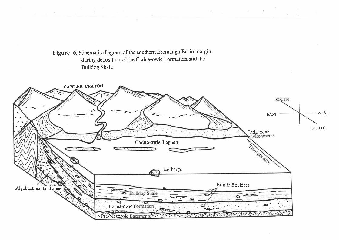
Figure 6. Sõhematic diagram of the southem Eromanga Basin margin
during deposition of the Cadna-owie Formation and the
Bulldog Shale
GAWLER CRATON
EAST WEST
NORTHTidal zone
Algebuckina Sandstone
-2 ---:-'------'
TPre-Mesozoic
-tr'-
Cadna-owie Lagoon
ice bergs
Erratic Boulders
:¡EÞê-Cadna -owte
Buried sediments underwent mesogenesis, while exposed Cretaceous sediments
were under conditions of the telogenetic regime, leading to the formaúon of a complex
and unique mineral assemblage.
In genetic terms, there are two mineral types were clearly identified - detrital and
authigenic. Detrital sand grade components are characterized by angular to subrounded
grains as a result of transport. These unstable sediments were heavily affected by
diagenesis. The most common diagenetic effects completely or partially dissolved
grains, some of which were replaced by later authigenic minerals. Identification of the
the two components (detrital and authigenic) is very importance to the environmental
interpretation.
Although smectite-zeolite and illite derived from smectite (chapter 5), and were
likely derived from the Proterozoic Gawler Ranges Volcanics, not all of these are
geographically with the source region. However, Gottardi and Galli (1985) stressed
that at larger distances from the source, only smectite remains in the sediment. The
Bulldog Shale and the lower part of the Cadna-owie Formation were deposited during
a trangression and as a consequence, nearshore sands fringing the margin became the
zone of concentrated coastal erosion of the Aptian-Albian seasonal deposits.
The presence of glauconite-rich deposits may be the result of feldsic volcanic
debris, and alteration of smectite/illites from the Precambrian basement which were
easily glauconised.close to the water/sediment interface of the bioturbated sediment.
Although scanning electron microscopy of quartz-sand surface textures and applied
statistical methods provide certain clues to the understanding of Cretaceous sediments,
the entire I methodology is yet to be perfected. However, on the basis of previous studies
and this study of quartz-sand surface textures, it is possible to conclude that glacial
features predominated in the sand fractions from the Cadna-owie Formation and the
Bulldog Shale. These features are best developed in tillites and their occturence in shale
suggests reworking from tillite, possibly including some of Cretaceous age. The
statistical: results on glacial features of the sand fraction from the Cretaceous
sediments are similar to Quaternary and modern glacial sediments (worldwide). It is
known that the process of glacial grinding and crushing produces mechanically broken
surfaces on grains. The reworked features can be seen in several samples and the
proportion increases in the near shore zone. The presence of aeolian together with
glacial grains indicates cold and possibly dry climatic conditions simila¡ to the Norttrern
Slope of Alaska today.
The model proposed in figure 6 is based on field observations, the study of
mineralogy and quartz sand surface textures of patchy outcrops and core. Further
research is needed, including detailed geological mapping, micro.paleontological study
and on the genesis of the sediments to reduce the uncertainity of the stratigraphy in the
60

area. The comparison of the depositional environment of the Cretaceous Southern
Eromanga Basin to high northern and southern latitudes (South America, New Zealand
and Anta¡ctica) in terms of fossils, mineralogical studies and quartz-sand surface
textures may provide more evidence on the palaeoclimate of the southern hemisphere
during the Cretaoeous.
.;:, 1
6t

Acknowledgements
I am indebted to my supervisors, Professor L.A. Frakes and Dr J.B. Jones of the
Department of Geology and Geophyiscs for their helpful advice and discussion during
the course of my research, and for their contructive criticisms, encouragement and
interest.
Nick, Jane and Neville assisted me during extended field studies and provided valuable
discussion and debate.
Other staff member Drs R.A.Both, V.A. Gostin, B. McGowran and R. Oliver also
gave; ¿dvise and encouragement to me in many aspects of my studies and thesis preparation.
I extend my appreciation and thanks to all other technical staff and fellow research
students of the Department of Geology and Geophysics; Wayne, Geof, Rick,
Evert, John, Christine and others.
I am grateful to Australia which gave me the opportunity to live and study in this
country, my brothers and sisters for their support, and finally my wife Phung and
daughter Thuan for their helpful companionship, endurance and patience during the
preparation of this thesis.

I
REFERENCES.Alley, N., 1987: Palynological dating and correlation of late Jurassic and earlyCretáceous sediments a¡ounã part of the southem margin of the Eromanga Basin. S.A.Department of Mines and Energy. Report No. 87i59. Unpublished.
Ambrose, G.J., 1979: Southern Eromanga Excursion. S.A. Dept. Mines andEnergy Report 9/143 unpublished.
Baker, JR.H.W., 1976 Environmental sensitivity of submicrosco_pic surfacetextures of quartz sand grains -A statistical evaluation. Journal of SedimentaryPetrology v.46 p.87 1-880.
Barker, I.C., 1983: The Geoloreference to the preceous opalunpublish.
Barnes, L.C., Scott, D.C., 1979: Opal at Stuart Creek, Charlie Swamp andYarra Wurta Cliff. Report No. 1
gy of the Coober Pedy Opal Field, with specialdeposits. M Sc thesis, University of Adelaide,
Barrie, J.V., Lewis, C.F.M., Fader, G.8., King,processes on the northeastern Grand banks of Newfoundlandrelic sediments. Marine Geology. v.57 p.2O9-227.
L.H., 1984: Seabed; Modern reworking of
Barrie, J.V., Collin, W.T., Clark, J.I., Lewis, C.F.M' Parrott, D.R.,1986: submersible observation and origin of an iceberg pit on the Grand BanksNewfoundland. Geol. Surv. of Canada, paper 86-14, p.251-258.
Barron, E.J., Wash¡ngton, W.M., lgEZ; Cretaceous Climate, ,{ compaflslon oÏatmostpheric simulatîons with the Geologic Record. Palaeogeography-Palaeoclimatology. -palaeoecology. v.40 p. I 03- 1 33.
Baskin, Y., 1956: A study of authigenic feldspars. Journal of Geology v.64 p.132-155.
Benbow, M.C., 1982: Explanatory Notes COOBER PEDY South Australia. 1:250
000 geological series. SHEET SFV53-6. Geol. Surv. of S.A.
Benson, L.V., Teague, L.S., 1982: Diagenesis of Basalt from the Pasco Basch,Washington, I. Distñbuiion and compositión of secondary mineral phases. Journal ofSedimentary Petrology , v.52 p.595-631.
Berner. R.4., 1964: Iron sulfides formed from aqueous solution at lowtemperatures and atmostpheric pressure. Geology v.72 p.293-306.
Berner, R.4., 1970: Sedimentary pyrite formation. Amer. Jour. Sci. v.268 p.l-23"
Berner, R.4., 1972: Sulfate reduction, pyrite formation, and the oc_eanic sulfurbudget.'In The Chaging chemistry of theÔceans eds. Dyrssen, D.; Jagner, C.D;Almqvist and Wiksell, Stockholm. p.347 -361.
Berner, R.4., 7974: Iron sulfides in Pleistocene deep Black Sea sediments and theirpaleo-oceanographic significance. In Black Sea Geology, Chemistry, Biology. Amer.Assoc. Petrol. Geol. Mem. v.20p.524-531.
Berner, R.4., 1981: Authigenic mineral formation resulting from organic matterdecomposition in modern sediments Frorschr. Miner. v.59 p.l17-135.

2
Berner, R.4., 1984: Sedimentary pyrite formation: an update. Geochim. et Cosmochim.Acta.v 4g p.605-615
Bhatia, M.R, Thomas, M., Boirle, J.M., 1984: Depositional frame work ofdiagenesis of the late Permian gas reservoirs of the Bonaparte basin. The APEAJournal v.4 p.299-313.
Blackwelder, L.P., Pilkey, O.H., 1972: Electron microscopy of quartz grainssurface textures the U.S Eastern Continental Margin. Joumal Sedimentary Petrologyv.42 p.520-526.
Brook, R., Clark, L.M., Thurston, E.F., 1950: Calcium carbonate and itshydrates. Phil. Trans. R. Soc. London, Serv A343, p 145.
Bornhold, 8.D., Giresse, P., 1985: Sediments on the continental shelf offVancouver Island, British Columbia, Can. Journal of Sedimentary of Petrology. v.55p.653-664.
Brown, H.Y.L., 1894: Report on the Geology Country from Strang\¡/ays Spring ofWilgena. Ann" Rep. Govt. Geol. S.A. Part. Paper No.25.
Brown, H.Y.L., 1898: Report on the Explorations in the western part of SouthAustralia. Parl. Paper. N0. 56.
Brown, H.Y.L., 1899: Geological Map of South Australia. Surveyor General 's
Office Adelaide.
Brown,H.Y.L., 1905: Report on geological Exploration in the west and north westof South Australia 5th Aust. Govt. Parl. Paper N0.71.
Brown, H.Y.L., 1908: Record of the Mines of South Australia.
Brown, J.8., I9l3: Depositional Histories of sand grain from surface textures.Nature
Bull, A.P. Goudie, S.4., 1987: An examination of the Ability of EnvironmentalReconsrruction by SEM Studies: A Case Study from the Plateau Drif Deposits ofOxfordshire, England. Clastic Particles (Eds. J.R., Marshall). p.36-50.
Burger, D., 1986: Palynology, cyclic sedimentation and palaeo-environment in theLate Mesozoic of the Eromanga Basin. Geol. Soc. Aust. Spec. Pub,l. v.l2 p.53-70.
Burley, S.D., Kantorovicz, \{augh, B.' 1987: Clastic diagen_esis. InSediméntology: Recent developments and applied aspects (Eds. Brenchley, P.J.,Williams, B.P.J.,) p.189-226.
Burst, J.F., 1969: Diagenesis of Guft Coast cleyey sediments and its possiblerelation to petroleum migration. Amer. Assoc. Petrol. Geol. Bull. v 53 p 73-93
Cheng, K.L., 1978: Lare quaternary deposit of the Newcastle port Stephen area as
revealéd by grain size analyiis and SEM microscopy. Journal and Proceedings. Royal.Soc. of N.S.W v.111 p.77-88.
Chumakov, N.M., l98l: Glacial events of the past and their geologicalsignificance. Palaeogeography, Palaeoclimatology, Palaeoecology. v.51 p.319-346.
Coats, R.P., Horwitz, R.C., Crawford, 4.R., Capana, 8., ThatchertD., 1969: Mt Þainter Province map sheet. 1: 125 000 . Geol. Surv. of South Australia

3
Crowell, J.C., 1982 Climatic Significance of sedimentary deposits containingdispersed megaclasts. (Eds. A.E.M. Nairn). Problems in palaeoclimatology, p.82-99.Interscience, NY.
Curtis, C.D., 1976: Stability of minerals in surface weathering reactions: a generalthermochemical model. Eanh Surf. Proc. v.l p.63-70.
Dalland, ^.,
1917: Erratic clast in the lower Tertiary deposits of Svalbar- Evidenceof transport by winter ice. Norst Polarinstitutt Arbok, 1976,p.l51-165.
David, T.W.; Edgeworth, T.G., Woolnough, 1905: Occurence of glendonitein New South Wales part I and 2. New South Wales Geological Survey Records VIII,t62-
Davies, D.K.; Ethrige, F.G., 1975: Sandstone composition and depositionalenvironment. Amer. Assoc. Petrol. Geol. Bull. v.59 p.239-264.
Deer, W.4., Howie, R.A., Zussman, J., 1966: An introduction to the rock-forming minerals. l-ongman.
Detterman, R.L., l9l3: Mesozoic sequence in Arctic . In M.G. Pitcher, ArcticGeology. Amer. Petrol. Geol., Tulsa, Oklahoma, U.S.A. p.376-378.
Elverhoi, A.; Bjorlykke, K., 1978: Sandstone diagenesis- Mesozoic rocks fromthe southern Spitsbergen. Norsk Polarinst.- Arb. v 1977 p 145-157 .
Embry, 4.F., 1984: Upper Jurassic to lower most Cretaceous stratigraphy,sediment ology and Petroleum Geology, Sverdrup Basin. CSPG-CSEG. NationalConvention. Abstracts. Calgary , Alberta. p.49-50.
Emery, K. O., 1955: Transportation of rock by drift wood. Journal of SedimentaryPetrology. v.25 p.51-57 .
Epshteyn, O.G., l9l8: Mesozoic-Cenozoic climates of northern Asia and glcial-marine deposits. Intemational Geology Review. v.20 p.19-58.
Exon, N.F., Senior, 8.R., 1976: The Cretaceous of the Eromanga Basin andSurat Basin. BMR Jour. Aust. Geol. Geophysics., v.l p.33-50.
Fenness.y , P.J., 1984: The geology of the BullDog Shale and the SouthwestEromanga basin (Maree area S.A). Honours thesis Monash University unpublished.
Fisher, 4.G., 1982: Long term climatic oscilations recorded and stratigraphy. InClimate and Earth History. National Academic Press, \ù/ashington ,p.97-1O4.
Flint, R.8., Ambrose, G.J., Campbell, K.S.W., 1980: Fossiliferous LowerDevonian boulders in Cretaceous sediments of the Great Artesian Basin. Royal. Soc.S.A. Trans. v.104 p.57-66.
Forbes, 8.G., 1966: The geology of the Marree l:250,000 map area. S.A. Geol.Surv. Rept. Invest. v.28.
Forbes, 8.J., 1982: Margin of the Eromanga Basin South Australia: A Review. In:Moore, P.S., Mount, T.J. (compilers), Eromanga Basin Symposium, SummaryPaper. Geol. Soc. Aust. and Pet. Exp. Soc. Aust., Adelaide.
Frakes, L.4., 1979: Climate throughout geologic time. Elsvier

4
Frakes, L.4., 1986: Mesozoic-Cainozoic climatic history and causes of glaciation.In Mesozoic and Cenozoic Oceans, Amer. Geophysics Union Geodynamic Series,v.15 p.33-45.
Frakes, L.A. and Francis, J.E. 1988 A guide to Phanerozoic cold polar climatesfrom high-latitude ice-rafting in the Cretaceous. Nature. v 333 p 547-549.
Freytag, I.8., 1966: Proposed rock units for marine Lower Cretaceous sediment inthe Oodnadatta region of the Great Artesian Basin. S.A. Geol. Surv. Q. Geol. Notes,v.18 p.3-7.
Freytag, I.8., Heath, G.R., Wopfner, H., 1967: OODNADATTA map sheet,Geological Atlast of South Australia, l:250 000 series. Geol. Surv. S.A.
Garrel, R.M.; Lerman,4., 1981: phanerozoic cycles of sedimentary carbon andsufur. Proc.Nat. Acad. Sci. v.78 p.4652-4656.
Geitzenauer, K.R., Margotis, S.V., Edwards, D.S., 1968: Evidenceconsistent with Eocene glaciation in the South Pacifrc deep sea sedimentary core. Ea¡thPlannetary lætters. v "4 p -17 3-177
Glaessner, M.F., Rao, V.R., 1955: Lower Cretaceous plant remains from thevicinity of Mount Babbage, South Australia. Royal Soc. S.A. Trans. v.78 p.134-140.
Glassman, J.R., 1982: Alteration of andersite in wet unstable soils of Oregon 'sVy'estern Cascades. Clay and Clay Miner. v.30 p.253-263.
Glover, J.E., Hosemann, P., 1970: Optical data on some authigenic feldsparsfrom'Western Autralia. Minerological Magazine v 37 p.587-592.
Goldich, S.S., 1938. A study of rock weathering. Journal of Geology. v.46 p.Il-58.
Gnldhaber, M.B.; Kaplan, I.R.. 1974: The sulfure cycle. In The Sea.
Newyork, Interscience Pub.r569-655.
Griffith, M., 1979: Toodla #1, well completion report, S.A. Dept. Min. and Ener.report 288 n 9 (unpublished).
Harris, W.K., 1970: An Upper Jurassic microflora from the westernGreat Artesian Basin, South Australia. S.A. Geol. Surv. Q. geol. Notes
margin of thev.35 p.3-8.
Heezen, B.C., 1963: Turbidite currents. The Sea. Newyork, Interscience Pub. v.3p.742-745.
Helgeson, H.C. Garrel, R.M., Mackenzie, F. T.' 1969: Evaluation ofinevèrsible reactions in geochemical processes involving mineral and aqueous solution--II, application. Geochim. et Cosmochim. Acta. v.33 p.455-481.
Higgs, R., 1978: Quartz sand surface features of Mesozoic-Cenozoic sand from theLabiador and Western Greenland continental Margins. Journal of SedimentaryPetrology. v.49 p.599-61 0.
Hill, P.R., Nadeau O.C., 1984: Grain surface textures of the late 'Wisconsinian
sand from the Canadian Beaufort Shelf. Journal of Sedimentary Petrology v.54p.1349-1357.

5
Hodel, K.L., Reimnitz, 8., Barnes, P.lV., 1988: Microtextures of quartzgrains from modernterrestrial and subaqueous environments, North Slope of Alaska.Journal of Sedimentary Petrology. v.58 p.24-32.
Hodson, A.V, Scott, W.8., l97O The identification of an ancient beach sandsby the combination of size analysis and electron microscopy. Sedimentology v.14p.67 -7 5.
Hower, J., 1961: Some factors concerning nature and origin of glauconite AmMiner. v.46 p.313-334.
Jack, R.L., 1915: Report on the region to the north and northwest of Tarcoola.Bull. geol. Surv. S.A. v.t5 Jotrns, R.R., 1968: Geology and mineral resources of theAndamooka- Torrens a¡ea. Geol. Surv. S.A. Bull.
Jeans, C.V., 1978: Silicification and associated clay assemblages in the Cretaceousma¡ine sediments of the southern England. Clay Miner.,v 17 p 101-156.
Jeans, C.V., Merriman, R.J., Mitchell, J.G. and Bland, D.J.' 1982:Volcanic clays in the Cretaceous of southern England and northern lreland. Claylr{iner.v17p105-156.
Johns, R. K., 1966: ANDAMOOKA map sheet, Geological Atlas of South Australial:250 000 Series Geological Surv. of South Australia.
Jones, J. 8., Fritzerald, M.J., 1987: An unusual and characteristic sedimentarymineral suite associated with the evolution of passive margins. Sedimentary Geology,v 52 p 45-63.
Jones, J.8., Segnit, E.R., 1966: the occurence and formation of opal at CooberPedy and Andamooka. Aust. Jour. Sc v 29 p 129-133.
Kastner, M. 1971: Authigenic feldspars in carbonate rocks Amer. Miner. v.56p.l4O3-1442
Kastner, M.; Siever, R.S., 1979: Low tempefature feldspars in sedimentaryrocks. Amer. Jour. of Science. v. 279 p. 435-479.
Keller, W. D., Reynolds, R. C., Inoune Atsuyuki , 1986: Morphology ofclay minerals in the smectite-to-illite conversion series by scanning electronmicroscopy. Clays and Clay Miner. v.34 p. 187-197.
Kemper, E., 1987: Das Klima der K¡eide-7nit. Geologisches Jahrbuch Reihe A
Kemper, 8., Schmitz, H.H., 1975: Stellate nodules from the-U¡Wr.p-eer paypo..ätioi ryãfungìnian] oiÁtiti" Canada.Geol.Surv. Can., paper 75-lc p 109-119
Kemper, E., Schmitz, H.H,, 1981: Glendonite-Indikatoren des Polarmarinen
Ablagerungsmilieus. Geol. Rundsch, v 70 p 759-793'
Kreig, G.W., 1982: Stratigraphy and Tectonics of The Dalhousie Anticline,Southlest Eromanga Basin. Eiomañga Basin Symposium Summary Papers Geol.Soc.Aust. and Pet. Explor. Soc. aust., Adelaide. p.145-158.
Krinsley, D.H., Takahashi, T., Silberman, M.L., Newman, M.S.' 1964:Transpoitation of sand grains along the Atlantic Shore of Long Ilþnd Newyork: Anapplication of electron microscopy. Marine Geology. v.2 p.100- 120.

6
Krinsley, D.H., Margolis, S.V., 1968: A study of quartz sand grain. surfacetexrures ïittr the Scannlng Electron Microscope. Trans. NewYork Aca. Science v.p.457 -47 5.
Krinsley, D.H., Donahue, J., 1968: Environmental interpretati_on oJ_lalg^ grainsurface textures by electron microscopy. Geol. Soc. Am. Bull. v.79 p.743-748.
Krinsley, D.H., Cavaltero, L., 1970: Scanning Electron microscpe- ofperiglacial eolian sand from [,ong Island NewYork. Journal of Sedimentary Petrologyv.40 p.1345-1350.
Krinsley, D.H., DoornkamP, J.C., 1973: Atlas of quartz sand surface textures.Cambridge at the University Press.
Krinsley, D.H., Marshall, J.R., 1987: Sand grain textural analysis: an
Assessment. Clastic Particles. Ed. Mazzullo..p. 3-15.
Kuenen, P.H., 1960: Experimental abrasion 4, aeolian action. Journal of Geologyv.68 p.427-449
Kuenen, P.H., Perdok, W.8., 1962: Experimental abrasion 5, frosting anddefrosting of quartz grarns. ¡ournal of Geology v.70 p.648-658.
Lindsay, J.M., 1975: Foraminiferal biostratigraphy of an Aptian marine shale fromGigginña, MUIì,LOOCOOPPIE 1:250 000 sñeet. S.R. Oept. Mines Report 75/126(unpublished).
Ludbrook, N.H., 1966 Cretaceous biostratigraphy of the Great Artesian Basin inSouth Australia. S.A. Geol.Surv. Bull v.40.
Margolis, S.V., 1968: Electron Microscopy of chemic¿l solution and mechanical
abrasion features on qu-ì" sand grains' Sedirirentary Geology v'2 p'243-256'
Margolis, s.v., Krinsley, D.H.,. 1974: Process of formation-a¡{ enviromentalo""ur?n."'of mióroleatur.ä'on detrital quartz grains. Am,-. Jour. of Science v- p.449-
464.
Margolis, S.V., Kennett, J., I97l: Cainozoic Palaeo_glacial hislgV of Antarctica
recorãed in Subantarctic dêep'sea cores Am. . Jour. of Sõience.v.27t p'l-36
Margolis, S.V., Krinsley, D.H.,-lg-7I: Submicroscopic ft-o-t^tt.g.on aeolian and
subaq:ueoús quartz sand grlins Geol. Soc. Am¡ . Bull. v.83 p.3395-3406
Marland, G., 1975: Stability of calcium carbonate hexahydrate (ikaite). Geochim.Cosmochim. Acta, v 39 p 83-91.
Marzof, J.8., 1976: Sand grain frosting and quartz overgrowth examined-by_scanning electron microscopy. ttre Navajo Sandstone (Jurassic?), Utah. Journal ofSedimentary Petrology v .46 p.960-9 12.
Mazzullo, J., Anderson, J.8., 1987: Analysis of Tillite and Glacial-Marine Sand
Grains. Clastic Particles. Ed. p.314-327.
Mazzullo, J., Ehrlich, R., Hemming, 4., 1984: Provenance and ArealDistribution ôf Late Pleisiocene and Holocene Quartz Sand on the Southern NewEngland Continental Shelf. Journal of Sedimentary of Petrology v.54 p.1335-1348.

7
Mazzutlo, J., Ehlich, R., Pilkey, O.H., 1982:_Lo_c_al^and distal origin of sand
in the Hatieras Abyssal plain. Ma¡ine Geology v.48 p.75-88.
McKirdy, D.M., Emmett, J.K., Mooney, B.4., Coxr- F.E-.-&. 'Watson'
8.L., 198é: Organic geochemical facies of the rCretaceous,Bu]!d_oqashale, western
Eromanga Basin] soutñ Ausrralia. Geol. soc. Aust. s.P. v.l2 p.287-3O4.
Middleton, V.G., David, P.M., 7979: Surface textures and roundilg 9! lual-z -ianO grains'on intertidal sand bars, Bay of Fundy. Nova Scotia Jour. v.16 p.2071- 2085-
Middleton, V.G., Anderson, J.8., 1987: Grain Shape__an-d !-urfaglTexturesÁnufysir of fiU and Glacial-Marine Sand Grain from the V/eddell and Ross Seas,
Antartica. Clatic particles (Eds. J.R. Marshall).
Millot, G., 1970: Geology of clays Springer Verlag.
Morgan, R., 1980 : Eustacy in the Australian Early and Mid Cretaceous. N-S.V/.
Geol. Surv. Bull. v.27 p.105.
Moore, P.S., 1986: Jurassic and Triassic stratigraphy a¡d hydrocarbon potential ofthe poólowanna Trough (Simpson Desert Reg-ion) in South Australia. Geol- Soc.
Aust. Spec. Publ. v.12 p.39-51.
Moore, P.S., Pitt, C.M., 1982: Cretaceous of the southwestern Eromanga Basin:
Sùãiigtuptrvl faciés va¡iations and petroleu1 pe.troleum potential. Eromanga Basin
Sy-pätii,ní. Moore P.S. and Mouit T.J. @ds.). Pet. Expl" Soc. Aust. and Geol'Soc. Aust. p.127-144.
Moore, P.S., P¡tt, G.M., Dettman, M.8., 1986: Thg Early cretaceousCoorikiâna Sandstonê and Tóolebuc Formation: their recognition and stratigraR!1c
*i.i¡"ifrip in the sourhwetern Eromanga Basin. Geol. Soõ. Aust. Spec. Publ,v'12 p'97-114.
Nicol, G.J., 1979: Geology of the Stuart Creek-Charlie Swamp -area, northern
South'Austrátiu. S.e. Dept.-ìvlines and Energy. Env. 3463 (unpublished).
Nieter,.W.M, Krinsley, D.H., 1976: The production and r999g1ition of aeolian
featurei on sañd grains by silt abrasion. Sedimentology v.23 p.713- 720.
Nordstrom, C.E., Margolis, S.V., 1972: Sedimentar-y history of CentralCalifornia Sirelf ruídr as rËueaÍed by Scanning Electron Microscopy. Journal ofSedimentary Petrology . v.42 p.527-536.
Norton, C.J., 1983: The t. Babbage a1d a study 9f +"genesis'of tñ"'Jurassic an the Southern Eromanga Basin.
University of Adelaide Ho
parkin , L.W., 1956: Notes on the younger glacial remnants of northern South
Australia. Royal Soc. S.A. Trans. v.79 p. 148-151.
Pauly, H., 1963: 'Ikaite' a new mineral from Greenland' Arctic, v l6 p 263-264'
Pearson, M.J., Watkin, D. Small, J.S., 1982: -Clay diagenesis,and -organicmaturarión in Northern Noith Sea sediments. Dev. Sedimentol' v 35 p 665-675.
Perry, E.A.ri Hower, J., 1970: Burial diagenesis in gulf coast pellitic sediments:
Clays and Clay Miner. v 18 p.165-177.

8
Petijohn, F.J., Potter, P.E., Siever, R., 1972: Sand and sandstone, Springer,Newyork p.616-619.
Phillips, J., 1983: The geology of the area south of Prospec.t-Hilt' Moolawatana,South Ausralia. Honours thesii, University of Adelaide (unpublished).
Pickton, C.4., 1981: Paleogene and Cretaceous dropstones in,Sp_i_t_zþergen In; Ea¡tltpre-pleiótocenê glacial recõrd (Eds. Hambrey, M.J., Harland, \W.8.,) p 567-569,Cambridge.
Pitt, G.M., 1976: Report of Geology, MURLOOCOPPIE 1: 250 000 area. S.A.Dept. Mines Report 76/64 (unpublished).
Pittman, E.D., 1972: Diagenesis of quartz in sandstones. Journal of SedimentaryPetrology. v.42 p.507-5 19.
Pye K., Krinsley, D.H., 1984: Petrographic examination of sedimentary rocks intfre SEtvt using Bácscattered Electron ãetectors. Journal Sedimentary Petrology v-54p.877-888.
Rai, S., 1987: Depositional environments of Quarternary dgposits of the Sg1_Vafleyur téueiled by scanning electron microscopy. Sedimentary Geology. v.52 p.127 -I48.
Rawlinson, T.E., 1878: Subterranean Drainage in the interior. Adelaide Phil. Soc.
Trans. Proc. and Rep. 1811-1878,p.124-126.
Sharp, M., Gomez,8., 1986: Processs of debris communication in the glacialenvirönment and implication for quartz sand grain micro-morphology. SedimentaryGeology. v.46. p.33-47.
Shearman , D.J., Smith, 4.J., 1985: Ikaite, the parent mineral of jarrowite-typepseudomorphs. Proc.Geol. Assoc., v 96 p 305-318.
Schneider, S.H., Thomson, S.R. Barron, E.J., 1985: Mid-Cretaceouscontinental surfaces tenperatures: are high CO2 concentrations needed to simulateabove freezingwinter condition ?. In Sunãquist ( Eds. Broecker, W. S.,)The CarbonCycle and Añnospheric CO2: Natural Vañation Archean to Present. Geop_hysical
Monograph ,v 32 i, SSS-SS9. Amer. Geophysical Union, V/ashington, D.C., U.S.A.
Srodon Jan, 1981:X-rayidentification of randomly interstratified illite/smectite inmixtures with discrete illite.Clay Miner.v.16 p.297 30a.
Srodon Jan, 1984 X-ray powder diffraction identifîcation of illitic materials. Claysand Clay Minerals v.32 p.337 -349.
Stieglitz, R.D., 1969: Surface textures of quartz and heavy mineral sand Erain¡fror¡ifresh \¡/ater environments an applcation óf Scanning Electron Microscopy. Geol.Soc. Am . Bull. v.80 p.2091-2094.
Strass, F.I., 1978: Microtextures of quartz sand grains in coastal and shelfsediments, More, Vy'estern Norway. Marine Geology. v.28 p.107-134-
Suess, 8., 1979: Mineral phases formed in anoxic sediment by microbialdecomposiiion of organic matÈr. Geochim. et Cosmochim.Acta.'v,43 p.339-352.
Suess, E., Balzer, W., Hesse, K.F., Muller, -P.J.r- Ungerer, C'A'r
W-f"t, G., 1982: Calôium Ôarbonaté Hexahydrate from ggryiqlch sediments ofthe Aniarctic Shelf. Precusors of Glendonites. Sciencev.216 p.l128-1131.
9
Thomson, 8.P., 1980: Geological Map of South Australia l:l 000 000 scale. Geol.Surv. of S.A.
Vnuk, M.F., 1978: Aspects of the geology of the Stuart Creek area, north of LakeTorreis South Ausnalia^. Honours thèsis, Uñiversiry of Adelaide (unpublished).
Waugh, 8., 1978: Authigenic K-felspar in Britisth Permo-Triassic sandstones. Jour.Geol. Soc. London. v.135 p.51-56.
Weaver, C.E., 1967: The signif,rcant of clay minerals in sediments In Fundamentalaspects bf peiroteum geocñemistry. (Eds-. Nagy, B. Elsevier, Amterdam, TheNetherlands) p 37-75.
Well O.C.,1974: Scanning Electron Microscopy Newyork McGraw Lltll42Ip
Wetton, J.E., 1984: SEM Petrology Atlas. The American Association of petroleum
Çeologists.Tulsa, Oklahoma, U.S.A.
Whalley lV.B., Krinsley, D.H, 1974: A Scanning Flectron M-icr-oscope-study ofsurface ie*tu.ei of quartz iand grains from glacial eávironment. Sedimentology v.21p.87-105.
Whatley, W.8., Langway, C.C., 1980: A Scanning Electron Microscopee*aminãtíon of iubgtaðiat þartz grains from camp genlgry core,Greenland-Apreliminary study. Journal of Glaciology. v.25 n0.91 p.125-131.
Whitehouse, F.W., The geology of the queendsland portion of the Great ArtesianBasin (AppÉNDIX'c. Tõ AR-ÍESIAN Wlren SUPPLIES IN QUEENSLAND).Dep. Co-Ord. Gen. Public'Works QLD.
white, s.H., shaw, H.F., Huggett, J.M., 1984 The use of BackscatteredElectron imaging for the peirogra!-nic study of sandstones and shales. Journal ofSedimentaryPetrology v.54 p.487-494.
Wilson, M.D., Pittman,E.D., 1977: Authigenic clays in sandstones: recognitionand influence on reseruói. próperties and pãlaeoenvironment analysis. Journal of
Sedimentary PetrologY v.47 P3-3 I
Woolnough, Dr.W.G., David, Sir T.W.E,r^1926: Cretaceous Glaciation inCentral Au"stialia. Geological Society of London Quart. Jour. v.32 p.332.351.
Wopfner H., Heath, G.R., 1963: Ne.w observations on the basal Creta-Jurassicsundston" in itre Mt Ánna region, South Australia. Aust. Jour. of Sci. v.26(2) p-57-
59.
wopfner, H., Freytag, I.B. and Heath, Q.R., l97O: Basal Jurassic toCretaceoui rocks of weste-"rn Great Artesian Basin. South Ausffalia, Stratigraphy and
environment. Am . Assoc. Pet. Geol. Bull. v.54 (3) p.383-416'
Wopfner, H., 1974: Post-Eocene history and_ stratigraphy of the north- eastern
Souih Australia. Trans. R. Soc. S.4., v.98 p.l-12
Wopfner, H., Callen, R. 4., Harris, W.K., 1974: The Lower Tertiary Ey¡9Formatioí of ine Soutúwesteri, Great Ártesian Basin. Jour. Geol. Soc. Aust. v.21p.17-51 .

ADDITIONAL REFERENCE
Gottardi, G. and Galli, E., 1985: Natural Zeolites, Springer Verlag, Berlin., 409p.
Reading, H.G., 1984: Sedimentary Environments and Facies, Blackwell Scientific Publications
479p.

TABLE OF SAMPLE LOCATIONS AND THEIR STRATIGRAPHICPOSITION IN THIS STUDY
889.85.04 Sandy-mudstone; 4m above the basal conglomerate layer Pelican Well section, Pelican
Creek, Pelican Well Formation.
839.86.05 Kaolinitic coarse grained sandstone; lm from the top part of the clast bearingmudstone, Pelican Well section, Trinity Well Sandstone (Plate lh).
889.85.07 Mudstone; 2m above the base of the Pelican Well section, Pelican Creek, Pelican WellFormation.
889.85.08 Sandy-mudstone; 6m above the basal conglomerate layer, Pelican Well section, Pelican
Creek, Pelican Well Formation.
889.86.10 Coarse grained sandstone; at the base of the Trinity Well Sandstone, Pelican Creek.
889.86.1 I Kaolinitic mudstone, 2m above the Cambrian basement, Stuart Creek Bed, Stuart Creek
Opal Digging, Stuart Creek Opal Field.
889.86.12 Fine grained sandstone;30m above the Pre-cambrian basement, Trinity Well section,Trinity Well Sandstone, Trinity Well.
889.86.14 Mudstone; l0m above the basal section, Trinity Well section, Trinity Well, Pelican WellFormation.
85g.86.22 Sandy-mudstone; l3m above the basal conglomerate layer, Trinity Well Section, TrinityWell, Pelican well Formation.
889.86.25 Pebbly-mudstone; l5m above the basal conglomerate layer, Trinity Well Section,Trinity Well, Pelican well Formation.
889.86.29 Mudstone; Matrix of the clast bearing shale; l7m above the basal conglomerate layer,Trinity Well Section, Trinity Well, Pelican well Formation.
889.86.30 Mudstone; Matrix of the clast bearing shale; l6m above the basal conglomerate layer,Trinity Well Section, Trinity Well, Pelican well Formation'
889.DBC.l Pebbly Mudstone; Cadna-owie Formation?, Coober Pedy.
889.CPl/2.LSIS. Sandstone; 0.5m below a lonestone, Cadna-owie Formation, Coober Pedy.
889.CP3/ l.LIB. Blackshale; 2m above the sandstone bed (Cadna-owie Formation?), Bulldog Shale,
Coober Pedy.
889.BLD.Bl Glauconitic silty shale; Bulldog Shale Coober Pedy.
889.153.65 Mudstone; 153.65m depth, Upper part of the Bulldog Shale, Toodla #1, Oodnadatta.
889.189.1 Bioturbated-mudstone; l89.lm depth, Bulldog Shale, Tooclla +1, Oodnadatta.
889.195.85 Mudstone; 195.85m depth, Bulldog Shale, Toodla #1, Oodnadatta'
889.218.4 Shaley-mudstone; 218.4m depth, Bulldog Shale, Toodla #1, Oodnadatta'
889.218.5 Shaley-mudstone; 218.5m depth, Bulldog Shale, Toodla #1, Oodnadatta.
889.224.45 Mudstone; 224A5m depth, Bulldog Shale, Toodla #1, Oodnadatta.
889.234.75 Bioturbated-mudstone; 234.75m depth, lower part of the Bulldog Shale, Toodla #1,Oodnadatta.

889.258.25 Glauconitic-sandstone; 258.25m depth, lower part of the Bulldog Shale, Toodla #1,Oodnadatta.
889.266.5 Bioturbated-sandstone; 266.5m depth, upper part of the Cadna-owie Formation,Toodla #1, Oodnadatta.
88g,266.6 Sideritic-sandstone; 266.6m depth, upper part of the Cadna-owie Formation, Toodla+1, Oodnadatta.

APPENDD( 1
MINERALOGICAL DES CRIPTION

Sample. 889.DTWI. At the base of the Pelican V/ell Formation, Trinity Well.
Hand specimen.
Dark grey calcitic pebbly mudstone, consisting of rough bands of very coarse-
angular pebbles in a fine-silty matrix, Detrital grains are poorly sorted and from poorly
defined sources.
SEM observation.
Angular-qua¡tz sand grains are the predominant featues in this sample. many of
the quartz grains are overgrown by silica, including crystal prism faces and silica
spheres. On analysis, detrital muscovite shows a variety of compositions and has good
cleavage under the secondary electron image. Detrital plagioclase grains are affected by
dissolution and hydrolysis, and often overgrown by authigenic K-feldspar. The
authigenic K-feldspar is widely developed within calcitic cement and displays euhedral
crystals. These feldspar grains contain small calcite inclusions and overlap the calcitic
cement. Much of the clay has been replaced by calcite crystals. In part, the cement
remains illitic in its morphology. The pebble consist of 60Vo of siltstone and shale;
30Vo of quartzite andl}Vo ofporphyry andquartz
Grain size20- 0.0lmm
Composition.
Quartz 30-40
Feldpar: 10-15
Muscovite: 5-10
Calcite: 10-20
Illite: 13- 10
Accessories: 2-5
(Iron oxide, illmenite...)
Diagnosi s. Cob ble-pebbly mudstone with calcitic- silty cement (diamicton).

Sample 889.D8C. l.Cadna-owie Formation?, Coober Pedy
Hand specimen.
Grey-green pebbly mudstone. Pebbles range from rounded to angular, and sizes
range from a few mm to 3-4 cm. Diagenesis the predominant feature in the sample
which includes silicified and gypsified haloes and fractures. Bioturbation is infilled by
glauconitic silty- shale.
SEM observations
Smectite is the major clay mineral in this sample. It consists of Na-Ca members.
Detrital illite/smectite shows rounded corners and edges. The clay has chemical
composition similar to glauconite grains and possibly originated from the Precambrian
Basement. Both cemented clays and calcite crystals are overgrown by authigenic K-
feldspar. Pyrite is deepty weathered to iron oxide (possible go€thite). Authigenic
kaolinite is aggregated among silica overgrowths, with poorly shown image and low
degree of crystallization (possible weathering effects). Zeolite is predominated by
clinoptilolite and analcite, and shows a deeply weathered surface. Gypsum fibres
overgrow detrital and authigenic grain surfaces.
Grain size: 20-0.0lmm
Composition.
Siltstone pebbles: 25-30
Quartzite pebbles: 10- 15
Quartz: 10-15
Feldspar: 10-12
Allogenic SÂ: 10-15
Znolite: 5-10
Gypsum: 4-5
Accessories: (Kaolinite, muscovite etc.) 2-3
Diagnosis. Pebbly mudstone with a smectitic-zeolitic-glauconitic silicified silty
matrix.

Sample 889. BDL.B1 Bulldog Shale Coober Pedy Region
Hand specimen.
Greyish-yellow glauconitic-micaeous siltstone containing vertical and horizontal
bioturbated burrows. These are infilled by pyritic shale. Gypsum and halite infill other
pore spaces.
SEM observation.
Detrital glauconite grains in an illite/smectite matrix. Grains show rounded edges
and corners. Authigenic K-feldspar infills pore spaces. Detrital muscovite appears both
parallel and perpendicular to the bedding. Detrital apatite shows rounded edges and
corners. Weathered pyrite replaced by iron oxide (goethite). Gypsum fibres infill
primary and secondary pore spaces, and are often associated with halite. Silica sphere
overgrows the surface of detrital sand grains and aggregates among illitic/smectitic
clay.
Detrital grain size 0.5-0.05 mm
Conrposition.
Quartz: 25-35
Glauconite: 10-15
Feldspar: 15-20
Muscovite: 3-5
Allogenic VS: 10-15
Gypsum: 5-7
Accessories: 2-5
(apatite, jarosite etc.)
Diagnosis. Marine-glauconitic silty shale, possibly deposited in shallow marine
environments, beach zone, shoreline environments.

889.CP3/l .LIB.Bulldog Shale,Coober Pedy
Hand specimen.
Dark grey-black shale, very fine laminae of clay layers.
SEM observation.
The rock contains massive shale layers, and consists of illite/smectite. Illite shows
scallop morphologies and high potassium components (estimated 65Vo of illitic layer).
Detrital muscovite, chlorite, biotite, quartz and organic fragments appear throughout
the sample. The euhed¡al pyrite framboids are well preserved and randomly distributed
Írmong illitic/smectitic layer.
Grain size:0.lmm-Pm
Composition:
Allogenic VS: 75-80
Detrital grains: 75-17
Muscovite, biotite, quartz, organic fragments and pyrite: 2-5'
Diagnosis: Pyritic-illitic/smectitic organic-rich shale. The rock was deposited in an
anoxidic environment.

8 89. CP 1/2.LS IS. Cadna-owie Formation ?, Coober Pedy
Hand specimen:
yellowish-gïeen feldsparthic medium sandstone. The fabric is characterized by
laminated dark-green layers of glauconite and white layers of quartz and feldspar,
These layers are loosely cemented by clays.
SEM observation.
Smectite infills spaces between detrital feldspar, quartz and glauconite, whose size
ranges from a few mm to |cm. Smectite showed cornflake morphology and draping
a¡ound detrital feldspar and clinoptilolite crystals. Fine-grained clinoptilolite infills
secondary pore space of detrital plagioclase. Analcite appears with well developed
crystal faces, and have cubic shapes. Analcite often having twin crystals. EDS shows
major elements such as SI, Al, Na, K and minor of Mg (which is possibly due to
contamination of other clay), with sizes ranging from lO-25 pm. Glauconite grains are
rounded, some are enwrapped by gypsum fibres. Dissolution of detrital grains has led
to replacement authigenic clays.
Grain size: ' 1.2-0.01mm
Composition:
Quartz: 25-30
Glauconite: l5-2O
Feldspar: 10-15
Smectite: 10-15
Clinoptilolite: 5-10
Gypsum: 2-1
Accessories. 3-5
(Muscovite, halite, apatite etc.).
Diagnosis. Glauconitic-quartzo-feldsparthic medium sandstone.possibly deposited
in shallow marine, shoal or beach environments.

889. 86.18 Pelican Well Formation, Pelican Well section.
Hand specimen.
Greyish-green feldspathic fine-grained bioturbated sandstone with white spots of
muscovite
SEM observation.
Authigenic S/I is the predominant clay in the sample. It is euhedral in shape and
shows a high degree of crystallization. It occurs as infilling in pore space or draped
a¡ound detrital feldspar grains. Detrital sand grains are often overgrown by authigenic
K-feldspar. Mosr of the detrital illite grains are replaced by silica. Dissolution of
plagioclase forms resorbed feldspar. Pyrite framboids are formed by clusters of small
individual octahedral pyrite crystats and often infilled worrn tube burrows'
Grain size. 0.8-0.06 mm
Composition:
Feldspar: 20-25
Quartz: 15-20
Glauconite: 5-10
Kaolinite: 10-15
Smectite/illite: 10- 1 5
Pyrite: 2-5
Accessories: 5
(micas, apatite, ilmenite etc.)
Diagnosis. Quartzo-glauconitic-feldspathic bioturbated greywacke with authigenic
kaolinite infilling secondary pore spaces.

889.153.65, Toodla #1, Upperpart of the Bulldog Shale, Oodnadatta.
Hand specimen.
Greyish-green bioturbated glauconitic micaceous sandstone with abundance of
organic fragments.
SEM observation.
The rock is dominated by detrital glauconite and quartz grains (size ranging from
0.1-0.6 mm) with minor feldspar, clinoptilolite and illite/smectite components.
Glauconite is pitted by the diagenetic process and has illite-like morphology. Detrital
quartz is overgrown by silica and authigenic feldspar. Authigenic illite/smectite occurs
as pore linings or infills pore space, and has pure end members of the illite/smectite
conversion series. Dissolution of detrital plagioclase grains is often infilled by
authigenic K-feldspar and zeolite. Pyrite framboids occur throughout the sample
ranging in size from 8-15 ¡rm. Large octahedral pyrite crystals infill worm tubes
burrows. The octahedral crystals have sizes up to 100 pm-
Grain size: 0.6-0.05 mm
Composition.
Glauconite: 2O-25
Quartz: 15-20
Feldspar: 10-15
Muscovite: 5-10
Smectite/illite: 20-25
Pyrite: 5-10
Accessories: 3-5
(apatite, ilmenite etc.)
Diagnosis. Glauconitic-quartzo-feldsparthic-pyritic siltstone with smectite/illite in
the matrix.

889.195.85 Toodla #1, Bulldog Shale, Oodnadatta.
Hand specimen.
Slump structure in green mudstone. There are cut and fill channels of fine-grained
glauconite with good sorting and low degrees of rounding.
SEM observation.
The matrix consists predominantly of authigenic smectite. The smectite consists of
both Ca-Na members, and shows honeycomb textures, estimated at about 90Vo of the
expandable layer. Pyrite is aggregated among mixed layer allogenic SÂ. The pyrite
framboids are formed by clusters of small individual octahedral crystals of a
microsphere (10-25 pm). The small octahedral crystals range in size from 1 to 1.5 pm.
Dissolution of plagioclase is often inf,rlled by zeolite (possible clinoptilolite) and K-
feldspar. Clinoptilolite and K-feldspar show euhedral crystals which reflect an
aurhigenic origin. They also infill pore spa.ces or drape around detrital sand grains.
Glauconite has composition and morphology similar to detrital illite/smectite grains.
Grain size. 1.0-0.1 mm
Composition.
Glauconite: 2O-25
Quartz: 10-15
Feldspar: 10-15
Smectite/illite: 20-25
Clinoptilolite: 2-5
Pyrite: 5-7
Accessories: 3-5
(muscovite, apatite etc.)
Diagnosis. Glauconitic-quartzo-feldspathic medium sandstone with smectite
dominant in the matrix.

889.234j5. Toodla #1, lower part of the Bulldog Shale, Oodnadatta.
Hand specimen.
Medium to coarse-grained glauconitic sandstone. The glauconite formed laminated
bands with heavy bioturbation which was infilled by white grey feldspathic sand
grains.
SEM observation.
The rock consists of well-sorted glauconitic-feldspathic medium sandstone, and is
cemented by authigenic smectite. Morphology of the smectite was estimated at about
80Vo of the expandable layer. The smectite consists of Ca-Na end members. Pyrite
appears as euhedral framboids or octahedral crystals and infills burrows. Dissolution
of plagioclase is infilled by authigenic K-fetdspars. Mordenite appears in pore space or
aggïegates among smectitic/illitic layers. Glauconite shows surface textures of detrital
illite and is pitted by diagenetic processes, in sizes ranging from 50 pm to 0'8mm'
Detrital apatite and muscovite show very little rounding.
Grain size. 1.0-0.05 mm
Composition:
Glauconite: 25-30
Quartz: 10-15
Smectite/illite: 25-30
Feldspar 10-15.
Z,eolite: 5-10
Accessories: 2-5
(muscovite, aPatite etc.).
Diagnosis. Glauconitic-feldsparthic bioturbated medium-grained sandstone in a
smectitic/illitic-zeolitic clay. Possily deposited in brackish-shallow marine environment

889.258.25. Toodla #1, Iower part of the Bulldog Shale, Oodnadatta.
Hand specimen.
Grey-green medium sandstone in bioturbation with micaceous and white
feldspathic layers.
SEM observation.
Glauconitic-feldspathic grains are predominant in the detrital components.
Dissolution of detrital plagioclase is infilled by authigenic potassium feldspar and
clinoptilolite. Most of the secondary quartz develops crystal prism faces. Smectite with
cornflake morphology infills pore space of the rock. Pyrite framboid infills burows,
sizes range from a few pm to 15 pm. The pyrite consists of a large number of small
octahedral crystals.
Grain size: 1.5-0.2 mm
Composition:
Quartz: 15-20
Glauconite: 15-20
Smectite/illite: 35-45
Feldspar: 10-15
Accessories: 4-1
( Muscovite, clinoptilolite etc.)
Diagnosis. Glauconitic-feldsparthic-pyritic bioturbated medium sandstone with
predominance of smectite. Possibly deposited in brackish-shatlow marine environment

889.266.5. Toodla #1, upper part of the Cadna-owie Formation, Oodnadatta'
Hand specimen.
Light to green grey intense bioturbated medium sandstone. Patches of altered-
feldspar grains with micro-micaceous silty matrix.
SEM observation.
The rock consists of rounded and subrounded quartz and detrital feldspar- Many
of the detrital grains are partly overgrown by authigenic feldspar. Partial dissolution of
detrital plagioclase grains, infilled by well crystallised authigenic feldspar and
clinoptilotite. Euhedral mordenite aggegates among authigenic kaolinite. Pyrite is less
common than in sample 889.258. Authigenic quartz overgrows on detrital grain
surfaces. Na-Ca-smectite infills pore spaces, and are estimated at gOVo of Smectite
layer. Detrital muscovite shows random orientation and slight abrasion occurs at
corners and edges. Rounded glauconite has the composition of illite, and appears to be
unoriented and isolated throughout the sample.
Grain size:1.2 - 0.04 mm
Composition:
Glauconite: 7-10
Feldspar: 10-15
Quartz: 20-30
Smectite: 20-25
Kaolinite: 5-10
Muscovite: 2-5
Accessories: 2-5
(apatite, organic fragments etc.)
Diagnosis: Bioturbated feldsphartic-glauconitic medium-grained sandstone.
Authigenic smectite, zeolite and authigenic K-feldspar inf,rlled pore space and matrix.
Possibly deposited in shallow marine or particularly lagoonal environment'

889.266.6. Toodla #1, upper part of the Cadna-owie Formation, Oodnadatta'
Hand specimen.
Brownish-yellow, medium-grained sandstone with a calcareous cement.
Laminated dark mud layers contain feldspathic and white kaolinite dots which appear
in patches throughout the samPle.
SEM observation.
Subrounded, medium-grained detrital feldspar and quartz grains are covered by
thin authigenic siderite crystals. Some siderites form rose shapes and euhedral
aggregated crystals which are similar to micro- glendonite. Detrital muscovite shows
angular edges and corners. Authigenic feldspar overgrows surface of the detrital sand
grains and infills pore space. Authigenic quartz has well developed crystal prism
faces, and appears among authigenic kaolinite. The kaolinite shows a very high degree
of crystallization. Dissolution of plagioclase and ferromagnesian minerals form a
significant secondary pore space. Small numbers of pyrite framboids aggregate among
smectite/illite layers (dark mud layers) and are often associated with clinoptilolite.
Grain size: 1.2-0.3 mm
Composition:
Quartz: 30-40
Feldspar: 10-15
Siderite: 10-15
Kaolinite: 15-20
Smectite: 10-15
Accessories: 5
( Muscovite, pyrite, clinoptilolite etc.).
Diagnosis. Sideritic-kaolinitic medium grained sandstone with kaolinite and
smectitic/illitic clay. Possibly deposited in marginal marine environment s (estuary)

APPENDD( 2
CHEMICAL ANALYSES

QUANÎIÎATIVB BLBCÎRON IIICROANALTSIS:
PoIÍshed thin eectione and poliehed blocks were coated with
carbon ln a etandard vacumm evaporator. The compositton of selected
grain minerale ütaa determined by using the JEOL 733 Superprobe model
eLectron microprobe anaryser, a NEvEX Tooo seriee enêrgy dispersive
eystem attached to a JEOL ?g3 analyaer. All determinatione uBe the
etandard oxide and eilicate analysis ( Griffin, 1979' based on I 5
elements aa follow: Na, ilg, Al, Si, P, S, CI, Fe, ßt Ca, Îi, V' Cr'
Iln and Ni. The analyti caI condi ti ons were: vol'tage $as I 5 ßV; bhe
beam current vtas 5 nA, b€am siZe 3-5 ¡n i n di ameber, counbi ng efaa
fixed at 6O seconds. The drifb facbor etaa very smalÌ, and for in each
gnain geveral analyaes r{ere t'aken'

Authigenic feldepar from Trinity Hetl Sandetone PH¡
Anal. No Rim.6 Rim.7 Rim.8 Rim.9
sio2 66. 61 66. I O 66. 61 66. 68
Al2O3 1?.72 1?. gg 1?. ?2 17 ' 50
HsO 0.15 0.19 0'1s
RzO 13.82 14.33 14.75 13'82
Na2O - 0. 44
Total: 98. 30 99' 05 99' 23 98' 00
Ca:Na:K0:0:1000:4.4:95'60:0:1000:0:100
Structural formulae (based on I oxigen per formula unit)
si 3.07 3'04 3'05 3'07
AL 0. 96 0. 97 0' 97 0' e6
M9 0.15 0.01 0'01
R o'81 o'84 o'87 0'81
Na - 0.04
Authigenic feldspar from Trinity tlell- Sandstone Pelican tle1l section
Anal. no Rim1 0 Rim2l Rím22 Rim24
si 02 66. 68
A1203 I 7. 50
R20 1 3. 86
Na2O O.21
Total: 98.25
Ca: Na: K 0: 2.2:
St ruc t ural
sI 3.08
A1 0. 95
K 0. 81
Na O. Oz
97. I 0:
lormul ae
66. 09
17.69
13. 70
97. 48
0: 100
( based
3.06
0.98
o. 82
67.79
'l s. 32
14. 30
66.93
'|'8. 02
15. 11
o.12
100. 18
1.2: 98. I100. 40
0: 0: 100 0
on g oxYgen Per formul-a
3.06
0. 98
o. 82
unit)
3.0s
1. 01
0.87
o. 01


Authigenic R-feldapar from "1rinÍty HelI eection ( 889. l2)
Anal. No E. XL E. XL F. PS F. PS
Siõt------'Gi:li ---ã8' 4T
At203 I 8. I I 17. 8? 18' 2g 1 8' 35
x.20 14.29 13- 60 15' ? g 15' 84
Na2O O.1? - O. 25 f' 24
lotar 1oo. 'l 4 99. 88 gg' ? s 100' 35
Ca:Na:R 0: 1.?z 98'3 O: 0: IOO O: 2'3: 97'7 0: 2'2z 97'I
Structural formulae (based on I oxygen per formula unit)
si 3. 06 3. 09 3' 03 3' 03
Al 0. 96 0. 95 o' 98 0' 97
R o,82 o. 78 o' 93 0' 93
Na o.ol - o'oz o'02


Glauconie from dePth 195.5m Butldog ShaIe, loodIa +1.
Fec Fec. FecAnal. No Fec.
sio2 51.84
Ti 02 0. 48
A1203 I t. 04
FeO 17.23
HsO 2.84
CaO 0.84
K20 5.94
Na2O 0.67
Total: 90. 88
ilgl( l{g+Fe) 22.7O
Structural formulae
si 6. 31
Ti 0. 05
A1 1.58
Fe 1.75
Ms 0. 51
Ca 0. 11
R o.92
Na 0.16
s2.95
0. 36
13. 66
15. 89
2.92
1.15
4. 52
1. 05
92.05
24. 70
( based on 1 I oxygen
6. 17
0.04
1.87
1. 54
0. 51
0. 14
o. 67
0. 23
52.72
o. 34
11.79
17. 43
3. 08
1.00
4. 92
0. 61
91. 89
24. OO
per formula
6. 29
0.03
1. 65
1.74
0. 55
0. 13
o.74
0. 14
unit)
53.86
0. 13
12.41
16. 98
3- 07
'1 ,16
5.06
0.64
93.31
24. 40
6.28
0.02
1 .70
1.70
0.53
o. 14
o. 75
0. 14

Detrital chlorite d"Ptt' 258' 5ø ToodI a {t'l , Eul l dog Shal' e, Oodnadat t a
4 52 3Anal. No
P2O5 O' 17
sioz 25- 26 25. 54 24' 07
A1203 22. 05 21 ' s8 17 ' 73
Feo 22. 05 22' 1 3 I 8' 50
Mno 0-28 0'18 0'14
MSo 15' O0 13' 8'l 12' 48
Cao O.1O ' 6'72
ß.?o o.21 0.23 o'24
Na2o 0. 44 O.28 0' 41
Total: 83. 39 83' 75 80' 46
Hg/ ( l'lg+Fe) 54. 80 55' 70 54' 60
StructuraL formulae ( based on 36 oxygen fer formula
P 0' 03
si 6.93 ?-12 7'11
Ar ?. 12 7. 09 6- 00
Fe 5.06 5'16 4'43
Mn O. 07 O' 04 0' 03
Ms 6.13 5'74 5'33
Ca O.O3 - 2'06
K o.o7 o.o8 0'08
Na O.23 0' I 5 O' 23
25. 86
2'.1 . 69
21.82
14. 80
o- 1?
0.20
o. 27
84.81
54. 70
uni t)
7. 06
6.98
4.98
6. 02
0. 05
0. 07
0.04
0.03
7. 92
6.46
4. 66
0.06
5. 42
0. 13
o. 02
0. 15
0.
29-
20.
20.
o.
't 3.
0,
0,
0
84
53
15
36
32
66
25
48
47
06
29
84
80

GlauconÍe at dePth 258.54 Bulldog ShaIe Toodla {}1, Oodnadatta
ÀnaI. No Fec' Fec. Fec' Fec'
si 02
Ti 02
A1203
FeO
s't . 55
0. t3
21. 65
6_ 13
Mgo 1. 63
CaO O.21
t(2o 8.90
Na2O 0. 91
Total: 91. I 1
Ì'lgl ( Ì'lg+ Fe ) 32. 20
StructuraL formulae
si 7.23
Ti 0.03
A1 3.68
Fe 0.76
ì,lg 0. 3 6
Ca 0. 03
K l. 69
Na 0.26
52. 45
o- 17
13.30
14. 83
3. 38
1.18
4.03
0. 91
90.25
28. 90
( based on 'l I
8. 35
o. 02
2. 49
1.97
0. 80
0. 20
0. 81
o. 28
oxyge n
51. 39
0.20
f 1. 56
17.90
2.99
1. O0
5. 02
o. 67
90. 73
22.90
per formula
8. 34
o. 02
2. 21
2.43
o. 72
o.17.
1. 04
o. 2'l
55. 06
0. 30
21.31
4. 83
2.60
2. O4
1. 86
3. 16
91. 16
48.90
unit)
8.07
0.03
3.68
0. 59
o. 57
0. 32
0.35
0.90
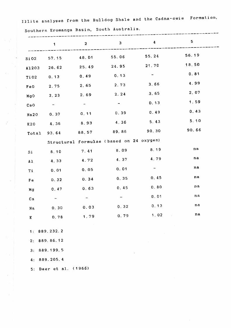
IIIite analysea from the Bu11do9 shaLe and the cadna-owie Formation'
' :::i:::-::::i:i:-:::::: -:::::-:::::::li------t2345
sio2 57.15 48. 01 55' 06 55' 24 56' I 9
Ar2o3 26.62 2s- 49 24' 9s 21 ', ? g I 8' 50
Tio2 o.13 0.49 0' 13 - 0' 81
4.99
2. 07
r" 59
0.43
5. 10
90.66
FeO
Mgo
CaO
Na2 O
R20
Tot al
si
AI
Ti
Fe
l.lg
Ca
Na
K
2.75
2.23
0.37
4. 36
93.64
St ruct ural
8. 10
4.33
0. 01
0.32
o. Ã7
2.65
2.69
0. 11
8. 93
88.57
formulae
7.41
4. 72
0. 05
0- 34
o. 63
2.73
2.24
0. 39
4. 36
89. 86
( baeed on
8.09
4. 37
0.01
0.35
0. 45
3. 66
3.65
0. 13
0.49
5. 43
90.30
24 oxygen)
8. 19
4. 79
0. 30
0.78
0.03
1.79
0. 32
o.79
0.45
0. 80
0. 01
0. 13
1.02
na
na
na
na
na
na
na
na
1: 889.232.2
2: 889.86.12
3: 889. I 99. 5
4; 889.205. 4
5: Deer et aI. ( I 966)

Biotite from Bulldog ShaIe, ToodIa {t't' Oodnadatta'
2 3 ( Deer eb aI. I 966)I
P205
Ti 02
si 02
A1203
FeO
XnO
xgo
Ca0
R20
Na2 O
Tot aI:
0. 10
40. o1
t 8" 31
21.96
10.89
3. 44
0.78
95.49
St ruc t ural
0.02
0. 11
41.28
17.05
25. 52
o. 21
10. 94
0. 10
0.64
95. 85
formulae ( based
0. 01
3, 32
36.67
16.80
21 .13
8. 82
8" 47
o. 77
95. 98
on 24 oxygen)
0. 41
6.06
3. 29
2- 92
2. 17
1.79
o. 25
2. 35
35. 98
18. 06
23.03
0. 13
7. 40
0. '1 5
9.09
P
Ti
Si
A1
Fe
Mn
Hg
R
Na
6. 37
3. 49
2.92
2.58
o.7
o. 25
6. 52
3. 417
1. 95
0.03
2. 57
0. 01
0. 19
96. 19
nd
nd
nd
nd
nd
nd
nd
nd
nd