Embed Size (px)
Citation preview

Institute of Geology and Seismology of
Republic of Moldova
Istanbul , 13 March 2014
Seismic Hazard Assessment Methodology
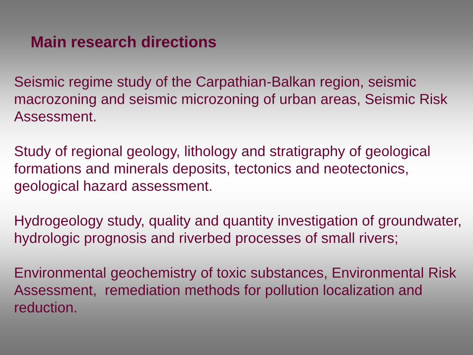
Seismic regime study of the Carpathian-Balkan region, seismic
macrozoning and seismic microzoning of urban areas, Seismic Risk
Assessment.
Study of regional geology, lithology and stratigraphy of geological
formations and minerals deposits, tectonics and neotectonics,
geological hazard assessment.
Hydrogeology study, quality and quantity investigation of groundwater,
hydrologic prognosis and riverbed processes of small rivers;
Environmental geochemistry of toxic substances, Environmental Risk
Assessment, remediation methods for pollution localization and
reduction.
Main research directions
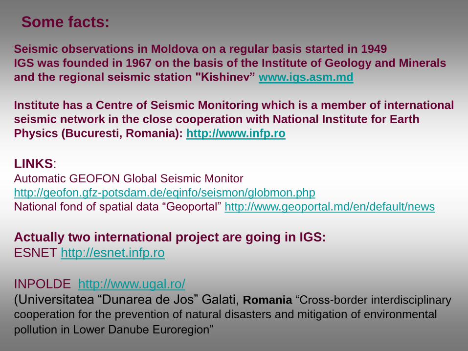
Seismic observations in Moldova on a regular basis started in 1949
IGS was founded in 1967 on the basis of the Institute of Geology and Minerals
and the regional seismic station "Kishinev” www.igs.asm.md
Institute has a Centre of Seismic Monitoring which is a member of international
seismic network in the close cooperation with National Institute for Earth
Physics (Bucuresti, Romania): http://www.infp.ro
LINKS: Automatic GEOFON Global Seismic Monitor
http://geofon.gfz-potsdam.de/eqinfo/seismon/globmon.php
National fond of spatial data “Geoportal” http://www.geoportal.md/en/default/news
Actually two international project are going in IGS:
ESNET http://esnet.infp.ro
INPOLDE http://www.ugal.ro/
(Universitatea “Dunarea de Jos” Galati, Romania “Cross-border interdisciplinary
cooperation for the prevention of natural disasters and mitigation of environmental
pollution in Lower Danube Euroregion”
Some facts:

Partners:
Romania – National Institute of Research Development for Earth Physics with an associate
partner The Foundation for Democracy, Culture and Liberty (Partner and project coordinator),
Moldova – Institute of Geology and Seismology, Academy of Sciences of Moldova,
Bulgaria – National Institute of Geophysics, Geodesy and Geography, Bulgarian Academy of
Science,
Turkey – International Blue Crescent Relief and Development Foundation.
Objectives of the project:
The prevention of natural disasters generated by earthquakes in Black Sea basin by developing
a joint monitoring and intervention concept.
All the countries involved in the project have their own studies, strategies, prevention and
intervention systems in case of earthquakes, but until now there has not been an integrated
approach so far in the Black Sea basin. Given the cross-border character of seismic activity, it is
necessary to have a cross-border approach on prevention, monitoring and intervention in case
of earthquakes.
Specific objectives:
1. The assessment of the disaster potential, with accent on the seismic risk degree and the
earthquakes effects in the intervention area.
2. To develop an integrated seismic monitoring and intervention concept.
3. To increase the capacity of local institutions emergency intervention units for joint response
activities in case of disasters.
ESNET Project – Black Sea Earthquake Safety Net(work)
Period – 2012 – 2014.
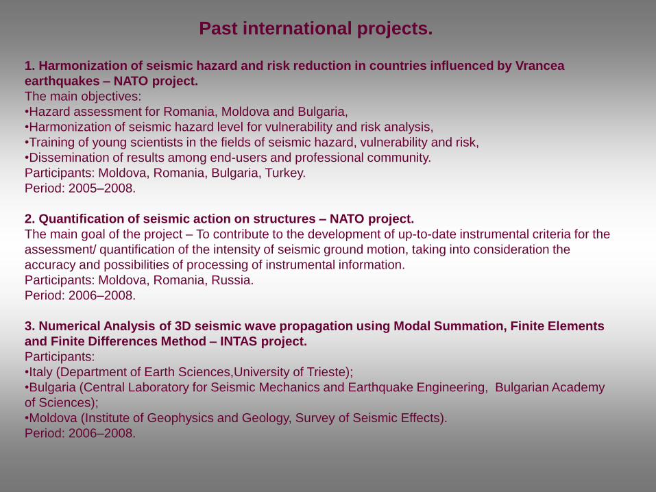
1. Harmonization of seismic hazard and risk reduction in countries influenced by Vrancea
earthquakes – NATO project.
The main objectives:
•Hazard assessment for Romania, Moldova and Bulgaria,
•Harmonization of seismic hazard level for vulnerability and risk analysis,
•Training of young scientists in the fields of seismic hazard, vulnerability and risk,
•Dissemination of results among end-users and professional community.
Participants: Moldova, Romania, Bulgaria, Turkey.
Period: 2005–2008.
2. Quantification of seismic action on structures – NATO project.
The main goal of the project – To contribute to the development of up-to-date instrumental criteria for the
assessment/ quantification of the intensity of seismic ground motion, taking into consideration the
accuracy and possibilities of processing of instrumental information.
Participants: Moldova, Romania, Russia.
Period: 2006–2008.
3. Numerical Analysis of 3D seismic wave propagation using Modal Summation, Finite Elements
and Finite Differences Method – INTAS project.
Participants:
•Italy (Department of Earth Sciences,University of Trieste);
•Bulgaria (Central Laboratory for Seismic Mechanics and Earthquake Engineering, Bulgarian Academy
of Sciences);
•Moldova (Institute of Geophysics and Geology, Survey of Seismic Effects).
Period: 2006–2008.
Past international projects.

National Network of Seismic Stations of the Republic of Moldova
№ Station Station
cod
Beginning
year φ°, N λº, E
1 Chişinău KIS 1949 46.9976 28.8175
2 Cahul KGL 1978 45.9053 28.2008
3 Leova LEOM 1982 46.4733 28.2467
4 Soroca SORM 1983 48.1350 28.3513
5 Giurgiuleşti GIUM 1988 45.4850 28.2081
The territory of the Republic of
Moldova is influenced by
earthquakes of intermediate depth
(80 – 150) from the Vrancea
seismic zone.
On average, strong earthquakes of magnitude M > 6 occur five times or more per
century. Some of them (November 10, 1940, March 4, 1977, August 31, 1986)

Vrancea Earthquake of November 10, 1940 (M=7,4)
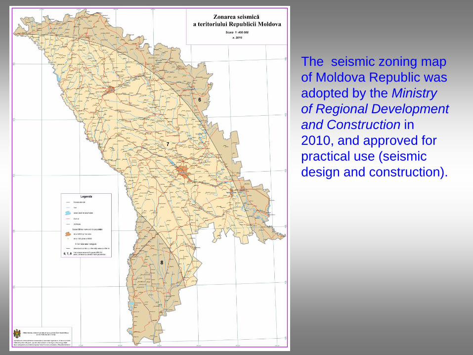
The seismic zoning map
of Moldova Republic was
adopted by the Ministry
of Regional Development
and Construction in
2010, and approved for
practical use (seismic
design and construction).

0.6
0.8
1.0
0.4
0.2
1.2
1.4
0.6
1.0
0.2
0.6
0.4
0.2
0.6
0.2
0.6
0.8
1.2
0.8
0.4
0.6
0.4
0.6
1.2
0.4
0.4
0.8
0.8
1.2
0.2
0.4
0.6
0.2
0.8
0.8
1.0
0.4
0.6
0.4
0.4
0.8
0.4
0.6
0.8
0.4
0.6
0.4
0.6
0.6
0.2
0.4
0.6
1.4
1.2
0.2
0.41
.4
0.4
0.6
0.2
0.6
0.2
0.2
0.2
1.0
0.8
1.2
0.2
0.6
0.8
0
.2
0.8
1.0
0.2
0.6
0.8
0.6
0.6
0.6
1.0
1.0
0.2
0.6
0.6
0.8
0.8
0.4
0.4
0.2
0.8
0.8
0.4
0.8
1.0
0.2
0.6
0.2
0.2
2
5
15
10
2
2
10
5
10
2
10
5
2
15
2
2
2
2
5
15
5
5
10
15
10
2
5
2
10
10
5
10
2
5
2
2
2
5
10
15
5
2
2
10
5
2
15
5
2
10
2
10
5
5
15
10
5
5
2
5
10
5
15
10
2
5
10
10
2
2
15
5
2
2
15
5
2
10
5
10
10
2
15
2
5
10
2
10
2
2
15
15
5
2
5
15
15
15
2
10
2
5
2
5
10
2
5
10
10
5
10
5
15
5
2
2
10
2
5
15
10
5
15
10
5
15
15
10
2
15
5
10
10
2
2
15 5
2
15
2
2
10
15
2
2
5
5
15
15
2
5
2
2
5
10
2
5
10
15
15
15
10
2
5
5
2
2
2
10
15
5
1 5
5
15
2
5
10
5
10
5
510
15
15
10
2
10
5
2
10
2
2
15
15
2
15
2
5
22
2
2
15
2
5
5
5
1 5
2
5
15
10
10
2
5
5
2
5
2
15
2
15
5
2
2
2
10
10
10
10
10
5
5
10
2
10
15
10
2
5
15
15
2
5
15
15
5
2
5
2
15
2
15
INSTITUTUL DE GEOFIZICA SI GEOLOGIE ASM
Microzonarea seismica a teritoriului or. Chisinau
Harta microzonarii seismice
pentru perioada 2005 - 2020
Autori: Alcaz V., Drumea A., Ghinsari V., Isicico E.
a. 2004
Legenda
Limitele oraşului
Reţea 1x1 km
Rîuri, pîrîuri
Bazine de apă
Cartiere
Izolinii ale perioadelor rezonanţei seismice
Pante cu pericolul alunecarilor de teren
Soluri tasabile, tip 2
Nivelul apelor freatice:
stabilit
probabil
Soluri artificiale:
2 - 5 м
5 - 10 м
>10 м
Zone ale intensitaţii seismice:
7 grade
8 grade
The seismic
microzonation
map of Kishinev
city has been
created. It was
adopted by the
Ministry of
Regional
Development
and Construction
in 2013.
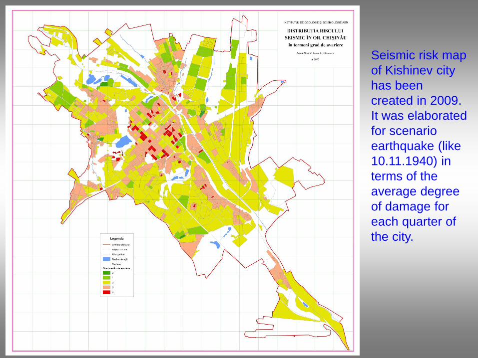
Seismic risk map
of Kishinev city
has been
created in 2009.
It was elaborated
for scenario
earthquake (like
10.11.1940) in
terms of the
average degree
of damage for
each quarter of
the city.
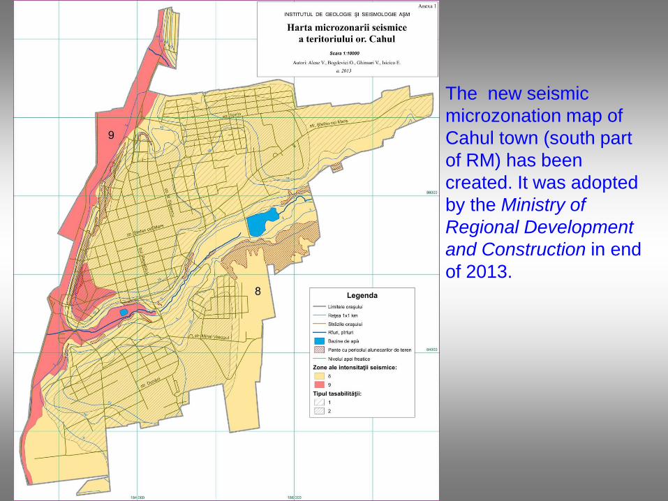
The new seismic
microzonation map of
Cahul town (south part
of RM) has been
created. It was adopted
by the Ministry of
Regional Development
and Construction in end
of 2013.

Seismic risk map of
Moldova Republic
has been created in
2013. It was
elaborated for
scenario earthquake
(like 10.11.1940) in
terms of the average
degree of damage
for each district.

Seismic risk map has
been created in 2013.
It was elaborated for
scenario earthquake
(like 10.11.1940) in
terms of the number of
destructed buildings
for each district.
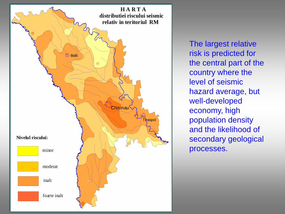
H A R T Adistributiei riscului seismic relativ in teritoriul RM
Nivelul riscului:
minor
moderat
inalt
foarte inalt
Chisinau
Balti
Tiraspol
The largest relative
risk is predicted for
the central part of the
country where the
level of seismic
hazard average, but
well-developed
economy, high
population density
and the likelihood of
secondary geological
processes.
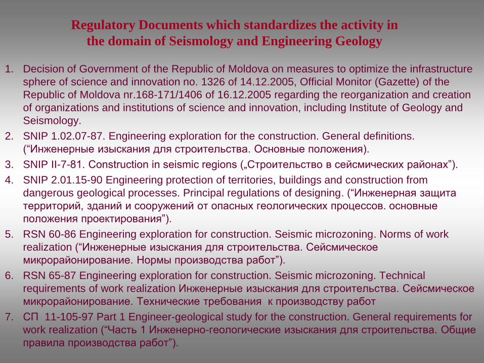
1. Decision of Government of the Republic of Moldova on measures to optimize the infrastructure
sphere of science and innovation no. 1326 of 14.12.2005, Official Monitor (Gazette) of the
Republic of Moldova nr.168-171/1406 of 16.12.2005 regarding the reorganization and creation
of organizations and institutions of science and innovation, including Institute of Geology and
Seismology.
2. SNIP 1.02.07-87. Engineering exploration for the construction. General definitions.
(“Инженерные изыскания для строительства. Основные положения).
3. SNIP II-7-81. Construction in seismic regions („Строительство в сейсмических районах”).
4. SNIP 2.01.15-90 Engineering protection of territories, buildings and construction from
dangerous geological processes. Principal regulations of designing. (“Инженерная защита
территорий, зданий и сооружений от опасных геологических процессов. основные
положения проектирования”).
5. RSN 60-86 Engineering exploration for construction. Seismic microzoning. Norms of work
realization (“Инженерные изыскания для строительства. Сейсмическое
микрорайонирование. Нормы производства работ”).
6. RSN 65-87 Engineering exploration for construction. Seismic microzoning. Technical
requirements of work realization Инженерные изыскания для строительства. Сейсмическое
микрорайонирование. Технические требования к производству работ
7. СП 11-105-97 Part 1 Engineer-geological study for the construction. General requirements for
work realization (“Часть 1 Инженерно-геологические изыскания для строительства. Общие
правила производства работ”).
Regulatory Documents which standardizes the activity in
the domain of Seismology and Engineering Geology

Study of the quantitative evaluation of seismic hazard and risk, consistent with pre-standard Eurocode-8 (Earthquake resistance of structure).
•Project objectives:
•Improve methods of forecasting the seismic hazard and risk;
•Improve the existing regulatory framework of protection population and infrastructure Republic of Moldova against earthquakes.
•Period: 2011–2014.
•Project leader: d. hab. Alcaz V.
Actual project