Embed Size (px)
Citation preview
1137
Seismicity in the vicinity of the SNORCLEcorridors of the northern Canadian Cordillera1, 2
John F. Cassidy, Garry C. Rogers, and J. Ristau
Abstract: The Slave – Northern Cordillera Lithospheric Evolution (SNORCLE) corridors of the northern Cordillerasample some of the most, and least, seismically active regions of Canada. The earthquake history of this region isshort. Precise determination of earthquake locations and depths is not possible even today. Nonetheless, significantgains in our knowledge of the seismicity of this region have been made in recent years from studies of historic earth-quakes, microseismicity studies, and advances in waveform modelling techniques combined with broadband data thatallow for determination of focal mechanisms and depths for moderate earthquakes. This article summarizes our currentknowledge of the seismicity and seismic hazards across the region. These detailed analyses have shown that (i) thelargest historical earthquakes have occurred in regions of ongoing microseismicity; (ii) the largest earthquakes haveoccurred in pairs or in swarms, suggesting that stress triggering is important in this region; (iii) the active faults areconcentrated in the offshore region; (iv) there is a concentration of seismicity in the Fold and Thrust belt, several hun-dred kilometres from the active plate margin; and (v) there is no seismicity associated with the Quaternary volcaniczone in northern British Columbia. Potentially damaging (magnitude M ≥ 5) earthquakes can be expected every fewyears in the vicinity of the northern Cordillera. The Mw = 7.9 Denali, Alaska, earthquake (where Mw is the momentmagnitude) was a good reminder that the effects of a large earthquake can be substantial, even hundreds of kilometresfrom the epicentre. Detailed studies of seismicity, earth structure, and tectonics, with the latter made possible in largepart by the SNORCLE transect, will allow for informed decision-making for resource development and the design ofsafe structures and infrastructure in the northern Canadian Cordillera.
Résumé : Les corridors du projet SNORCLE de la Cordillère septentrionale permettent d’échantillonner quelques-unesdes régions sismiques les plus et les moins actives du Canada. L’histoire des séismes de cette région est brève. Mêmede nos jours, il est impossible de déterminer avec précision les endroits et les profondeurs des séismes. Néanmoins, aucours des dernières années, nous avons grandement amélioré notre compréhension de la séismicité de cette région àpartir de l’histoire des tremblements de terre, des études de microsismicité et des avances dans les techniques de modé-lisation des types d’ondes, combinés aux données à large bande qui permettent de déterminer les mécanismes focaux etles profondeurs de séismes à intensité modérée. Le présent article résume nos connaissances actuelles de la séismicitéet des dangers sismiques à travers la région. Ces analyses détaillées ont démontré que : (i) les plus grands séismeshistoriques ont eu lieu dans des régions de microsismicité active; (ii) les plus grands séismes ont eu lieu par paires oupar groupes, suggérant que le déclenchement des contraintes est important dans cette région; (iii) les failles actives sontconcentrées dans la région au large des côtes; (iv) la sismicité est concentrée dans la ceinture de plis et de chevauche-ments, à plusieurs centaines de kilomètres de la bordure de la plaque active et (v) il n’y a pas de sismicité associée àla zone volcanique quaternaire du nord de la Colombie-Britannique. L’on peut s’attendre à des séismes (M ≥ 5) causantpotentiellement des dommages régulièrement à quelques années d’intervalle à proximité de la Cordillère septentrionale.Le séisme de Denali, en Alaska, MW = 7,9, est un bon rappel que les effets d’un gros séisme peuvent être substantiels,même à des centaines de kilomètres de l’épicentre. Des études détaillées de la sismicité, de la structure de la Terre etde la tectonique, cette dernière étant rendue possible en grande partie par le transect SNORCLE, permettront deprendre des décisions informées dans le développement des ressources et la conception de structures et d’infrastructuressécuritaires dans la Cordillère canadienne septentrionale.
[Traduit par la Rédaction] Cassidy et al. 1148
Can. J. Earth Sci. 42: 1137–1148 (2005) doi: 10.1139/E04-063 © 2005 NRC Canada
Received 8 December 2003. Accepted 12 August 2004. Published on the NRC Research Press Web site at http://cjes.nrc.ca on23 September 2005.
Paper handled by Associate Editor R.M. Clowes.
J.F. Cassidy3 and G.C. Rogers. Pacific Geoscience Centre, Geological Survey of Canada, P.O. Box 6000, Sidney, BC V8L 4B2,Canada and School of Earth and Ocean Sciences, University of Victoria, Victoria, BC V8W 2Y2, CanadaJ. Ristau. School of Earth and Ocean Sciences, University of Victoria, Victoria, BC V8W 2Y2, Canada.
1This article is one of a selection of papers published in this Special Issue on The Lithoprobe Slave – Northern CordilleraLithospheric Evolution (SNORCLE) transect.
2Geological Survey of Canada Contribution 2003147; Lithoprobe Publication 1376.3Corresponding author (e-mail: [email protected]).

© 2005 NRC Canada
1138 Can. J. Earth Sci. Vol. 42, 2005
Introduction
The Slave – Northern Cordillera Lithospheric Evolution(SNORCLE) corridors extend from the active plate tectonicboundaries along western North America, over the accretedterranes of the northern Cordillera, to the stable NorthAmerican craton (Fig. 1). Not coincidentally, the SNORCLEtransects also span a range of seismic hazard, from the high-est in Canada (near the western ends of corridors 2 and 3) tothe lowest in Canada (corridor 1). Although the region issparsely populated, the seismicity and seismic hazard arenonetheless of great interest, notably for decision-makingand design considerations for proposed gas pipelines in thenorthern Cordillera and for possible oil and gas developmentin the Beaufort Sea. The interest in seismic hazard in thisarea is especially relevant given the recent (November 2002)Mw = 7.9 earthquake along the Denali fault in Alaska, just tothe west of the Yukon Territory (where MW is the momentmagnitude).
The purpose of this article is to provide an overview ofthe seismicity (including studies of the largest earthquakesand microseismicity studies), the history of earthquake mon-itoring, the accuracy of epicentral locations and focal depths,focal mechanisms, and the correlation with mapped surfacefeatures. Although not in the immediate SNORCLE transectarea, we include a summary of the effects of the Mw = 7.9Denali, Alaska, earthquake of November 2002 to illustratethe impact (and signature) of large earthquakes in remote ar-eas of the northern Cordillera. Combining these seismicityobservations with the new results from analyses of theSNORCLE data (presented in this volume) will allow forbetter estimates of the earthquake hazard and an improvedunderstanding of the active tectonics of the northern Cana-dian Cordillera.
Tectonics
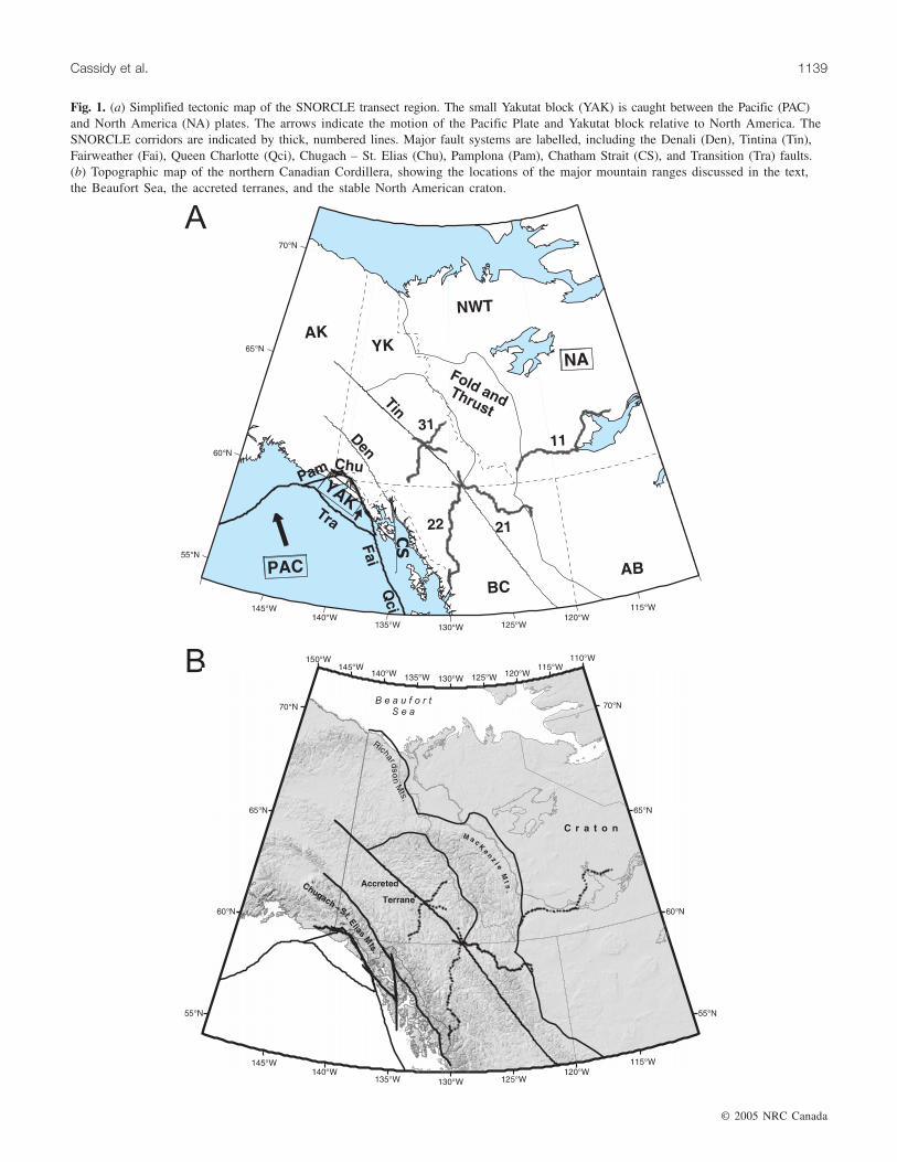
Just to the west of the SNORCLE transects, the active tec-tonics is dominated by the �6 cm/year northwestward mo-tion of the Pacific Plate relative to the North America Plate.Along the west coast, this motion is largely accommodatedby dextral transcurrent motion along the Queen Charlotteand Fairweather faults (Fig. 1a). In Alaska, this motion isaccommodated by subduction of the Pacific Plate beneathNorth America. In southeast Alaska, the transition from strike-slip to subduction is denoted by the oblique collision of theYakutat block (Plafker 1987; Mazzotti and Hyndman 2002)(Fig. 1a). This collision results in significant crustal shorteningand uplift in the St. Elias and Chugach Mountains region(Fig. 1b) of the southwest Yukon Territory and northwestBritish Columbia. Just inboard of the major plate boundariesis a series of fault zones, the most notable of which is theDenali fault zone (Fig. 1a). Other faults in this region (to bediscussed in more detail in the following sections) includethe Totschunda fault; the Shakwak, Duke River, and Daltonfaults (which make up the Denali fault system in Canada);the Chugach – St. Elias fault zone; and the Chatham Straitfault. To the east of the coastal fault zones is a series ofaccreted terranes (Snyder et al. 2002; Wheeler and McFeely1991). The Tintina fault zone (Fig. 1a) is a prominent featurethat extends across the northern Cordillera (Wheeler andMcFeely 1991) and has been interpreted as a major intra-
continental transform fault (Roddick 1967). Estimates forright-lateral displacement along this fault zone range from450 km to more than 1000 km since the middle to Late Cre-taceous (based on geological evidence, e.g., Gabrielse 1985,and palaeomagnetic evidence, e.g., Irving et al. 1996). Tothe east of the Tintina fault zone, SNORCLE lines 2 and 3cross ancestral North America and terminate in the vicinityof the Fold and Thrust belt (see Welford et al. 2001). Fartherto the east, SNORCLE line 1 extends from the eastern limitof cordilleran deformation, crossing Proterozoic strata (Snyderet al. 2002) to the Archean cratonic shield, containing theoldest known rocks on Earth.
Seismicity
Earthquake monitoringThe following entry in the diary of a Hudson’s Bay trader
at Fort Selkirk, Yukon, on 27 December 1850 represents thefirst written report of an earthquake in the Yukon Territory(Jackson 1990): “… 33 min after 3 Oclock (sic) an earth-quake was felt here for the space of one minute. It was verysevere and the houses were visibly affected.”
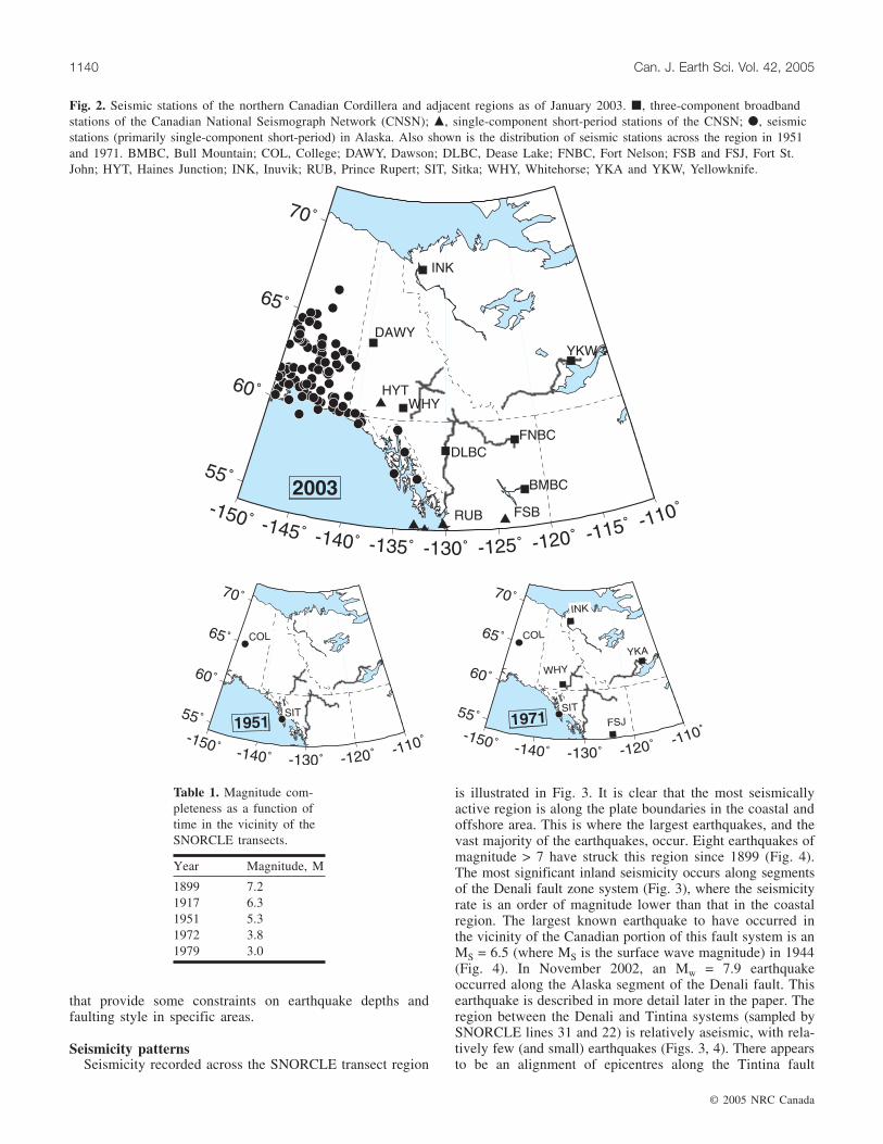
Instrumental earthquake recording in western Canada beganin 1899 when a seismograph was deployed at Victoria, BritishColumbia. The first seismograph station in the vicinity ofthe northern Cordillera began operating at Sitka, Alaska(SIT), in 1904. It was not until 1935 that another stationbegan operating at College, Alaska (COL). These were low-gain instruments, however, and it was not until the late-1950sto mid-1960s when short-period, high-gain seismographs inAlaska and the Canadian National Seismograph Networkwere deployed that smaller (to about local magnitude ML ≈ 5)earthquakes could be located in the Yukon and NorthwestTerritories. Local seismographs were deployed in the imme-diate area during the late 1960s to early 1970s (Inuvik (INK)in 1969 and Whitehorse (WHY) in 1971). As of 2003 (Fig. 2),there are additional seismic stations in the region (HainesJunction, Yukon (HYT); Dease Lake, B.C. (DLBC); andFort Nelson, B.C. (FNBC)), but this still represents a sparsenetwork with limited epicentral resolution and little to nocontrol on focal depth. In terms of “completeness,” i.e., thelevel at which all earthquakes of a certain magnitude havebeen recorded, the values estimated (Adams and Halchuk2003) for seismic source zones in the vicinity of theSNORCLE transects are given in Table 1. What is apparentfrom Table 1 is that there is a relatively short time period(20–30 years) for which all minor earthquakes (ML > 3) inthe region have been recorded.
As of 2003, the magnitude completeness level across theregion ranges from 2.7 to 3.0. With the exception of earth-quakes near the Alaska–Yukon border (which can be locatedusing both Canadian and Alaska data due to real-time dataexchange), only three or four stations are available for locatingmost earthquakes in the northern Cordillera. As a result, thelocation errors are on the order of ±5–10 km horizontally,and focal depths cannot be routinely determined. Uncer-tainties this large, combined with the lack of depth control,make it very difficult to associate earthquake activity withspecific surface faults or structures. There have been a fewdetailed studies (summarized later in this paper), however,
© 2005 NRC Canada
Cassidy et al. 1139
Fig. 1. (a) Simplified tectonic map of the SNORCLE transect region. The small Yakutat block (YAK) is caught between the Pacific (PAC)and North America (NA) plates. The arrows indicate the motion of the Pacific Plate and Yakutat block relative to North America. TheSNORCLE corridors are indicated by thick, numbered lines. Major fault systems are labelled, including the Denali (Den), Tintina (Tin),Fairweather (Fai), Queen Charlotte (Qci), Chugach – St. Elias (Chu), Pamplona (Pam), Chatham Strait (CS), and Transition (Tra) faults.(b) Topographic map of the northern Canadian Cordillera, showing the locations of the major mountain ranges discussed in the text,the Beaufort Sea, the accreted terranes, and the stable North American craton.
© 2005 NRC Canada
1140 Can. J. Earth Sci. Vol. 42, 2005
that provide some constraints on earthquake depths andfaulting style in specific areas.
Seismicity patternsSeismicity recorded across the SNORCLE transect region
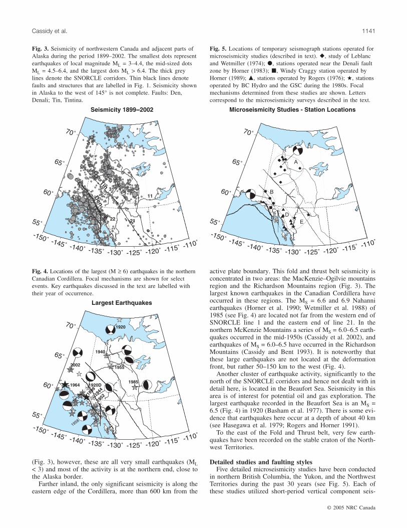
is illustrated in Fig. 3. It is clear that the most seismicallyactive region is along the plate boundaries in the coastal andoffshore area. This is where the largest earthquakes, and thevast majority of the earthquakes, occur. Eight earthquakes ofmagnitude > 7 have struck this region since 1899 (Fig. 4).The most significant inland seismicity occurs along segmentsof the Denali fault zone system (Fig. 3), where the seismicityrate is an order of magnitude lower than that in the coastalregion. The largest known earthquake to have occurred inthe vicinity of the Canadian portion of this fault system is anMS = 6.5 (where MS is the surface wave magnitude) in 1944(Fig. 4). In November 2002, an Mw = 7.9 earthquakeoccurred along the Alaska segment of the Denali fault. Thisearthquake is described in more detail later in the paper. Theregion between the Denali and Tintina systems (sampled bySNORCLE lines 31 and 22) is relatively aseismic, with rela-tively few (and small) earthquakes (Figs. 3, 4). There appearsto be an alignment of epicentres along the Tintina fault
Fig. 2. Seismic stations of the northern Canadian Cordillera and adjacent regions as of January 2003. �, three-component broadbandstations of the Canadian National Seismograph Network (CNSN); �, single-component short-period stations of the CNSN; �, seismicstations (primarily single-component short-period) in Alaska. Also shown is the distribution of seismic stations across the region in 1951and 1971. BMBC, Bull Mountain; COL, College; DAWY, Dawson; DLBC, Dease Lake; FNBC, Fort Nelson; FSB and FSJ, Fort St.John; HYT, Haines Junction; INK, Inuvik; RUB, Prince Rupert; SIT, Sitka; WHY, Whitehorse; YKA and YKW, Yellowknife.
Year Magnitude, M
1899 7.21917 6.31951 5.31972 3.81979 3.0
Table 1. Magnitude com-pleteness as a function oftime in the vicinity of theSNORCLE transects.
© 2005 NRC Canada
Cassidy et al. 1141
(Fig. 3), however, these are all very small earthquakes (ML< 3) and most of the activity is at the northern end, close tothe Alaska border.
Farther inland, the only significant seismicity is along theeastern edge of the Cordillera, more than 600 km from the
active plate boundary. This fold and thrust belt seismicity isconcentrated in two areas: the MacKenzie–Ogilvie mountainsregion and the Richardson Mountains region (Fig. 3). Thelargest known earthquakes in the Canadian Cordillera haveoccurred in these regions. The MS = 6.6 and 6.9 Nahanniearthquakes (Horner et al. 1990; Wetmiller et al. 1988) of1985 (see Fig. 4) are located not far from the western end ofSNORCLE line 1 and the eastern end of line 21. In thenorthern McKenzie Mountains a series of MS = 6.0–6.5 earth-quakes occurred in the mid-1950s (Cassidy et al. 2002), andearthquakes of MS = 6.0–6.5 have occurred in the RichardsonMountains (Cassidy and Bent 1993). It is noteworthy thatthese large earthquakes are not located at the deformationfront, but rather 50–150 km to the west (Fig. 4).
Another cluster of earthquake activity, significantly to thenorth of the SNORCLE corridors and hence not dealt with indetail here, is located in the Beaufort Sea. Seismicity in thisarea is of interest for potential oil and gas exploration. Thelargest earthquake recorded in the Beaufort Sea is an MS =6.5 (Fig. 4) in 1920 (Basham et al. 1977). There is some evi-dence that earthquakes here occur at a depth of about 40 km(see Hasegawa et al. 1979; Rogers and Horner 1991).
To the east of the Fold and Thrust belt, very few earth-quakes have been recorded on the stable craton of the North-west Territories.
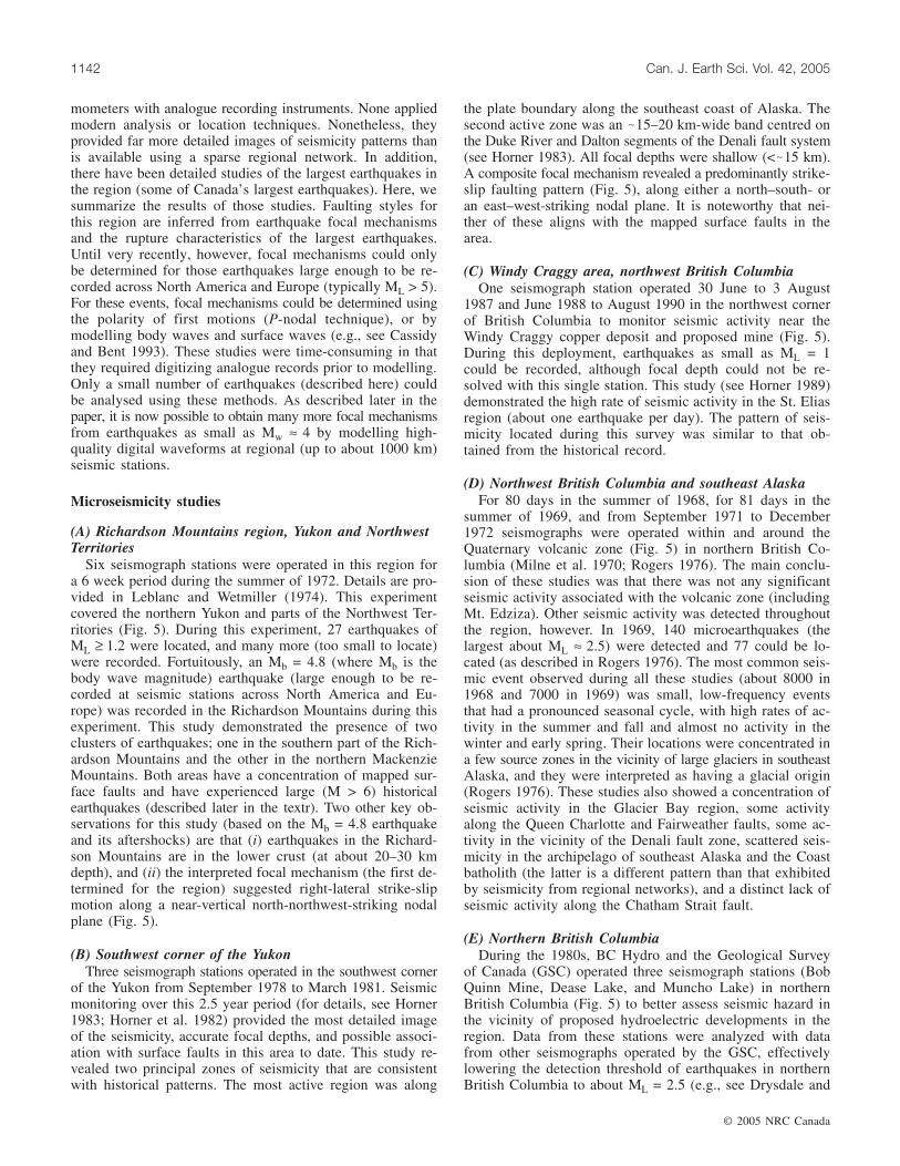
Detailed studies and faulting stylesFive detailed microseismicity studies have been conducted
in northern British Columbia, the Yukon, and the NorthwestTerritories during the past 30 years (see Fig. 5). Each ofthese studies utilized short-period vertical component seis-
Fig. 3. Seismicity of northwestern Canada and adjacent parts ofAlaska during the period 1899–2002. The smallest dots representearthquakes of local magnitude ML = 3–4.4, the mid-sized dotsML = 4.5–6.4, and the largest dots ML > 6.4. The thick greylines denote the SNORCLE corridors. Thin black lines denotefaults and structures that are labelled in Fig. 1. Seismicity shownin Alaska to the west of 145° is not complete. Faults: Den,Denali; Tin, Tintina.
Fig. 4. Locations of the largest (M ≥ 6) earthquakes in the northernCanadian Cordillera. Focal mechanisms are shown for selectevents. Key earthquakes discussed in the text are labelled withtheir year of occurrence.
Fig. 5. Locations of temporary seismograph stations operated formicroseismicity studies (described in text). �, study of Leblancand Wetmiller (1974); �, stations operated near the Denali faultzone by Horner (1983); �, Windy Craggy station operated byHorner (1989); �, stations operated by Rogers (1976); �, stationsoperated by BC Hydro and the GSC during the 1980s. Focalmechanisms determined from these studies are shown. Letterscorrespond to the microseismicity surveys described in the text.
© 2005 NRC Canada
1142 Can. J. Earth Sci. Vol. 42, 2005
mometers with analogue recording instruments. None appliedmodern analysis or location techniques. Nonetheless, theyprovided far more detailed images of seismicity patterns thanis available using a sparse regional network. In addition,there have been detailed studies of the largest earthquakes inthe region (some of Canada’s largest earthquakes). Here, wesummarize the results of those studies. Faulting styles forthis region are inferred from earthquake focal mechanismsand the rupture characteristics of the largest earthquakes.Until very recently, however, focal mechanisms could onlybe determined for those earthquakes large enough to be re-corded across North America and Europe (typically ML > 5).For these events, focal mechanisms could be determined usingthe polarity of first motions (P-nodal technique), or bymodelling body waves and surface waves (e.g., see Cassidyand Bent 1993). These studies were time-consuming in thatthey required digitizing analogue records prior to modelling.Only a small number of earthquakes (described here) couldbe analysed using these methods. As described later in thepaper, it is now possible to obtain many more focal mechanismsfrom earthquakes as small as Mw ≈ 4 by modelling high-quality digital waveforms at regional (up to about 1000 km)seismic stations.
Microseismicity studies
(A) Richardson Mountains region, Yukon and NorthwestTerritories
Six seismograph stations were operated in this region fora 6 week period during the summer of 1972. Details are pro-vided in Leblanc and Wetmiller (1974). This experimentcovered the northern Yukon and parts of the Northwest Ter-ritories (Fig. 5). During this experiment, 27 earthquakes ofML ≥ 1.2 were located, and many more (too small to locate)were recorded. Fortuitously, an Mb = 4.8 (where Mb is thebody wave magnitude) earthquake (large enough to be re-corded at seismic stations across North America and Eu-rope) was recorded in the Richardson Mountains during thisexperiment. This study demonstrated the presence of twoclusters of earthquakes; one in the southern part of the Rich-ardson Mountains and the other in the northern MackenzieMountains. Both areas have a concentration of mapped sur-face faults and have experienced large (M > 6) historicalearthquakes (described later in the textr). Two other key ob-servations for this study (based on the Mb = 4.8 earthquakeand its aftershocks) are that (i) earthquakes in the Richard-son Mountains are in the lower crust (at about 20–30 kmdepth), and (ii) the interpreted focal mechanism (the first de-termined for the region) suggested right-lateral strike-slipmotion along a near-vertical north-northwest-striking nodalplane (Fig. 5).
(B) Southwest corner of the YukonThree seismograph stations operated in the southwest corner
of the Yukon from September 1978 to March 1981. Seismicmonitoring over this 2.5 year period (for details, see Horner1983; Horner et al. 1982) provided the most detailed imageof the seismicity, accurate focal depths, and possible associ-ation with surface faults in this area to date. This study re-vealed two principal zones of seismicity that are consistentwith historical patterns. The most active region was along
the plate boundary along the southeast coast of Alaska. Thesecond active zone was an �15–20 km-wide band centred onthe Duke River and Dalton segments of the Denali fault system(see Horner 1983). All focal depths were shallow (<�15 km).A composite focal mechanism revealed a predominantly strike-slip faulting pattern (Fig. 5), along either a north–south- oran east–west-striking nodal plane. It is noteworthy that nei-ther of these aligns with the mapped surface faults in thearea.
(C) Windy Craggy area, northwest British ColumbiaOne seismograph station operated 30 June to 3 August
1987 and June 1988 to August 1990 in the northwest cornerof British Columbia to monitor seismic activity near theWindy Craggy copper deposit and proposed mine (Fig. 5).During this deployment, earthquakes as small as ML = 1could be recorded, although focal depth could not be re-solved with this single station. This study (see Horner 1989)demonstrated the high rate of seismic activity in the St. Eliasregion (about one earthquake per day). The pattern of seis-micity located during this survey was similar to that ob-tained from the historical record.
(D) Northwest British Columbia and southeast AlaskaFor 80 days in the summer of 1968, for 81 days in the
summer of 1969, and from September 1971 to December1972 seismographs were operated within and around theQuaternary volcanic zone (Fig. 5) in northern British Co-lumbia (Milne et al. 1970; Rogers 1976). The main conclu-sion of these studies was that there was not any significantseismic activity associated with the volcanic zone (includingMt. Edziza). Other seismic activity was detected throughoutthe region, however. In 1969, 140 microearthquakes (thelargest about ML ≈ 2.5) were detected and 77 could be lo-cated (as described in Rogers 1976). The most common seis-mic event observed during all these studies (about 8000 in1968 and 7000 in 1969) was small, low-frequency eventsthat had a pronounced seasonal cycle, with high rates of ac-tivity in the summer and fall and almost no activity in thewinter and early spring. Their locations were concentrated ina few source zones in the vicinity of large glaciers in southeastAlaska, and they were interpreted as having a glacial origin(Rogers 1976). These studies also showed a concentration ofseismic activity in the Glacier Bay region, some activityalong the Queen Charlotte and Fairweather faults, some ac-tivity in the vicinity of the Denali fault zone, scattered seis-micity in the archipelago of southeast Alaska and the Coastbatholith (the latter is a different pattern than that exhibitedby seismicity from regional networks), and a distinct lack ofseismic activity along the Chatham Strait fault.
(E) Northern British ColumbiaDuring the 1980s, BC Hydro and the Geological Survey
of Canada (GSC) operated three seismograph stations (BobQuinn Mine, Dease Lake, and Muncho Lake) in northernBritish Columbia (Fig. 5) to better assess seismic hazard inthe vicinity of proposed hydroelectric developments in theregion. Data from these stations were analyzed with datafrom other seismographs operated by the GSC, effectivelylowering the detection threshold of earthquakes in northernBritish Columbia to about ML = 2.5 (e.g., see Drysdale and

© 2005 NRC Canada
Cassidy et al. 1143
Horner 1986). This monitoring revealed for the first time aweak band of seismicity associated with the Rocky Moun-tain Trench, a southward extension of the Tintina fault. Italso reconfirmed that there was no significant seismicity as-sociated with the volcanic zone, and that the most numerousseismic events recorded were the seasonal events emanatingfrom the region of large glaciers in southeast Alaska.
Largest earthquakesThe largest earthquakes in the area (Fig. 4) have occurred
offshore, along the active plate boundaries. The most signifi-cant earthquakes are the 1899 sequence (including Mw = 7.8,8.2, and 8.6 events) at Yakutat Bay, an MS = 7.9 event in1958 along the Fairweather fault (Fig. 4), an Mw = 7.6 eventin 1972 at the northern end of the Queen Charlotte fault, anMw = 7.5 event in 1979 along the Chugach – St. Elias faultzone, and a series of events (including two of MS = 7.6)within the Pacific Plate. In the onshore region, the largestearthquakes include the 2002 Mw = 7.9 Denali, Alaska,earthquake, the 1944 MS = 6.5 earthquake near the Daltonfault in the southern Yukon (Fig. 4), the 1920 MS = 6 earth-quake near the Denali fault in the Yukon, and the 1952 MS =6 event near the northern end of the Fairweather fault in theYukon.
The 3 November 2002 Mw = 7.9 Denali fault (Alaska)earthquake was one of the largest strike-slip earthquakesever recorded in North America. It was felt strongly acrossthe Yukon and Northwest Territories (causing some minordamage) and caused buildings to sway and generated seichesup to 2400 km from the epicentre (Cassidy and Rogers 2004).It was located �300 km to the west of the Alaska–Yukonborder and produced surface rupture over a distance of �340 km(Eberhart-Phillips et al. 2003). This earthquake sequencebegan as a thrust event (40 km of surface rupture) on a pre-viously unrecognized fault (the Susitna Glacier fault) andthen ruptured 218 km as right-lateral strike slip down theDenali fault towards Canada (see fig. 2 in Eberhart-Phillipset al. 2003). It is noteworthy that rupture did not continuealong the Denali fault into Canada, but rather stepped to theright through a 14 km-wide series of fault segments and con-tinued as right-lateral slip along the Totschunda fault system(fig. 2 in Eberhart-Phillips et al. 2003) for another 76 km.This earthquake produced up to 3.3 m of dip slip on theSusitna Glacier fault, up to 8.8 m of right-lateral slip alongthe Denali fault, and up to 2.1 m of horizontal slip along theTotschunda fault. This earthquake triggered thousands oflandslides (some as large as 30 million m3 of rock and ice),most within about 30 km of the surface rupture. There werealso liquefaction features observed over a large area (Eberhart-Phillips et al. 2003). The 3 November 2002 earthquake occurredonly 11 days after an Mw = 6.7 earthquake that occurred onthe Denali fault about 55 km to the west. This earthquakeand its aftershock sequence, which extended to within 10 kmof the 3 November event, increased the Coulomb stress (andtherefore the chance of an earthquake) along both the SusitnaGlacier fault and the Denali fault. The Mw = 7.9 earthquakehas, in turn, increased the Coulomb stress along both theDenali fault in the vicinity of the Alaska–Yukon border andthe Totschunda fault. An initial overview of this earthquakesequence and its effects is presented in Eberhart-Phillips etal. (2003). Numerous detailed studies of all aspects of this
earthquake sequence will be published over the next fewyears.
In the interior of the northern Cordillera, as described earlier,the largest earthquakes have occurred several hundred kilo-metres to the east of the plate margin, in the Fold and Thrustbelt. A pair of large earthquakes (MS = 6.2 and 6.5) occurredin the Richardson Mountains of the northern Yukon Territory(about 450 km north of SNORCLE line 31) in May and Juneof 1940. A detailed analysis of these earthquakes (Cassidyand Bent 1993) showed that they represented strike-slip faultingalong either a north–south-striking fault or an east–west-striking fault. The earthquakes occurred at depths of 7–14 kmand had no detected (or felt) aftershocks. It is likely thatthese earthquakes are associated with the predominant north–south-striking Richardson Fault system.
A sequence of strong earthquakes (MS = 6–6.5) occurredin the northern Mackenzie Mountains (about 300 km northof SNORCLE line 31) between 1953 and 1957. A detailedstudy of these earthquakes (Cassidy et al. 2002) showed thatthey were very different from those in the Richardson Moun-tains. These earthquakes had a well-defined aftershock se-quence, occurred at a depth range of 7–15 km, and wereassociated with thrust faulting along a shallow-dipping planedipping to the north-northeast.
The largest earthquake recorded in the northern Cordillera,an MS = 6.9 event, occurred in the southern MackenzieMountains (near the western end of SNORCLE line 11) inDecember 1985 (Fig. 4). This earthquake was part of asequence that included an MS = 6.6 earthquake in October1985 and an MS = 6 event in March 1988. These earth-quakes were a surprise in that they were nearly two magnitudeunits larger than any previous earthquakes in the southernMackenzie Mountains. They were also significantly largerthan any previous earthquakes recorded (maximum MS =6.5) within the entire northern Canadian Cordillera. Detailedanalyses of these earthquakes are presented in Horner et al.(1990), Wetmiller et al. (1988), and Weichert et al. (1986).Due to the large number of stations around the world recordingthese earthquakes, and because portable instruments weredeployed in the area to record aftershocks, these are the beststudied earthquakes in the region to date. The focal depthsfor these earthquakes and their hundreds of aftershocks (Horneret al. 1990) are 4–10 km. Despite the relatively shallowdepth, no surface break was found. Focal mechanisms foreach of these events show thrust faulting on north-striking,shallow, west-dipping planes. It is noteworthy that the mainshocks or aftershocks did not fall on any of the mappedLaramide faults in the area (Wetmiller et al. 1988). Thisearthquake sequence was interpreted (Horner et al. 1990) ashaving occurred along a buried Laramide-age fault that ex-tends through the Proterozoic and Paleozoic rocks above thecrystalline basement. These earthquakes were likely causedby the regional compressive stress field activating optimallyaligned faults. This suggested the possibility that large earth-quakes may occur anywhere within the Fold and Thrust beltof the Canadian Cordillera, with clear implications for earth-quake hazards. A number of other earthquake-related studieswere conducted in the Nahanni region following this earth-quake sequence. These include (i) mapping earthquake-inducedlandslides (Evans et al. 1987), and (ii) remote sensing methods,including optical, synthetic aperture radar (SAR), and SAR
interferometry (InSAR). Both the optical and SAR imagesrevealed north–south- and east–west-trending tectonic fea-tures that had not previously been mapped (Moon et al.1991, 1998) and demonstrated the applications of these tech-niques to hazard studies in remote areas.
It is noteworthy that the largest earthquakes within thenorthern Cordillera have occurred either in pairs (1940Richardson Mountains earthquakes, 2002 Denali Alaska earth-quakes) or in swarms (1953–1957 northern MackenzieMountains, 1985–1988 Nahanni). This suggests that Cou-lomb stress triggering plays an important role in this region.
Faulting styles and relationship with surface faultsFaulting styles in the study area can be inferred from
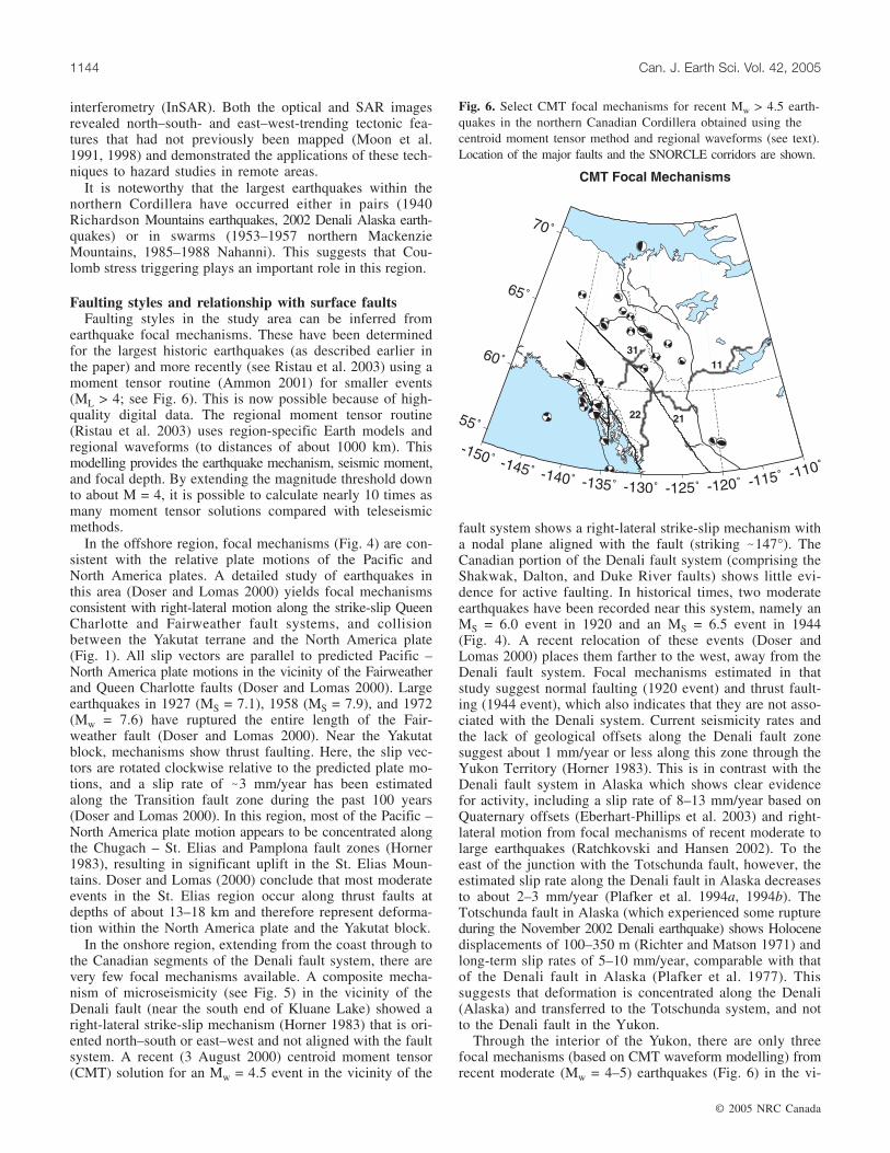
earthquake focal mechanisms. These have been determinedfor the largest historic earthquakes (as described earlier inthe paper) and more recently (see Ristau et al. 2003) using amoment tensor routine (Ammon 2001) for smaller events(ML > 4; see Fig. 6). This is now possible because of high-quality digital data. The regional moment tensor routine(Ristau et al. 2003) uses region-specific Earth models andregional waveforms (to distances of about 1000 km). Thismodelling provides the earthquake mechanism, seismic moment,and focal depth. By extending the magnitude threshold downto about M = 4, it is possible to calculate nearly 10 times asmany moment tensor solutions compared with teleseismicmethods.
In the offshore region, focal mechanisms (Fig. 4) are con-sistent with the relative plate motions of the Pacific andNorth America plates. A detailed study of earthquakes inthis area (Doser and Lomas 2000) yields focal mechanismsconsistent with right-lateral motion along the strike-slip QueenCharlotte and Fairweather fault systems, and collisionbetween the Yakutat terrane and the North America plate(Fig. 1). All slip vectors are parallel to predicted Pacific –North America plate motions in the vicinity of the Fairweatherand Queen Charlotte faults (Doser and Lomas 2000). Largeearthquakes in 1927 (MS = 7.1), 1958 (MS = 7.9), and 1972(Mw = 7.6) have ruptured the entire length of the Fair-weather fault (Doser and Lomas 2000). Near the Yakutatblock, mechanisms show thrust faulting. Here, the slip vec-tors are rotated clockwise relative to the predicted plate mo-tions, and a slip rate of �3 mm/year has been estimatedalong the Transition fault zone during the past 100 years(Doser and Lomas 2000). In this region, most of the Pacific –North America plate motion appears to be concentrated alongthe Chugach – St. Elias and Pamplona fault zones (Horner1983), resulting in significant uplift in the St. Elias Moun-tains. Doser and Lomas (2000) conclude that most moderateevents in the St. Elias region occur along thrust faults atdepths of about 13–18 km and therefore represent deforma-tion within the North America plate and the Yakutat block.
In the onshore region, extending from the coast through tothe Canadian segments of the Denali fault system, there arevery few focal mechanisms available. A composite mecha-nism of microseismicity (see Fig. 5) in the vicinity of theDenali fault (near the south end of Kluane Lake) showed aright-lateral strike-slip mechanism (Horner 1983) that is ori-ented north–south or east–west and not aligned with the faultsystem. A recent (3 August 2000) centroid moment tensor(CMT) solution for an Mw = 4.5 event in the vicinity of the
fault system shows a right-lateral strike-slip mechanism witha nodal plane aligned with the fault (striking �147°). TheCanadian portion of the Denali fault system (comprising theShakwak, Dalton, and Duke River faults) shows little evi-dence for active faulting. In historical times, two moderateearthquakes have been recorded near this system, namely anMS = 6.0 event in 1920 and an MS = 6.5 event in 1944(Fig. 4). A recent relocation of these events (Doser andLomas 2000) places them farther to the west, away from theDenali fault system. Focal mechanisms estimated in thatstudy suggest normal faulting (1920 event) and thrust fault-ing (1944 event), which also indicates that they are not asso-ciated with the Denali system. Current seismicity rates andthe lack of geological offsets along the Denali fault zonesuggest about 1 mm/year or less along this zone through theYukon Territory (Horner 1983). This is in contrast with theDenali fault system in Alaska which shows clear evidencefor activity, including a slip rate of 8–13 mm/year based onQuaternary offsets (Eberhart-Phillips et al. 2003) and right-lateral motion from focal mechanisms of recent moderate tolarge earthquakes (Ratchkovski and Hansen 2002). To theeast of the junction with the Totschunda fault, however, theestimated slip rate along the Denali fault in Alaska decreasesto about 2–3 mm/year (Plafker et al. 1994a, 1994b). TheTotschunda fault in Alaska (which experienced some ruptureduring the November 2002 Denali earthquake) shows Holocenedisplacements of 100–350 m (Richter and Matson 1971) andlong-term slip rates of 5–10 mm/year, comparable with thatof the Denali fault in Alaska (Plafker et al. 1977). Thissuggests that deformation is concentrated along the Denali(Alaska) and transferred to the Totschunda system, and notto the Denali fault in the Yukon.
Through the interior of the Yukon, there are only threefocal mechanisms (based on CMT waveform modelling) fromrecent moderate (Mw = 4–5) earthquakes (Fig. 6) in the vi-
© 2005 NRC Canada
1144 Can. J. Earth Sci. Vol. 42, 2005
Fig. 6. Select CMT focal mechanisms for recent Mw > 4.5 earth-quakes in the northern Canadian Cordillera obtained using thecentroid moment tensor method and regional waveforms (see text).Location of the major faults and the SNORCLE corridors are shown.
cinity of the Tintina fault system. They are a mixture ofright-lateral strike-slip and thrust earthquakes and do notalign with the orientation of the Tintina fault system.
Throughout the Fold and Thrust belt of the northeasternCanadian Cordillera, focal mechanisms have been determinedfor the largest historic earthquakes, the Nahanni earthquakesof the 1980s, and, using the CMT method, several dozenmodern moderate-sized earthquakes (Fig. 6). In the MackenzieMountains, the largest earthquakes all show thrust faulting.CMT solutions show mainly thrust faulting, but with somestrike-slip mechanisms also (see Fig. 6). In the southernMackenzie Mountains the nodal planes are oriented north–south, in agreement with local geological structures. In thenorthern Mackenzie Mountains, the nodal planes rotate tobecome northwest–southeast, again in agreement with theorientation of local surface structures. In the RichardsonMountains, focal mechanisms of the larger historic earth-quakes show right-lateral strike-slip faulting, consistent withthe Richardson fault system. The pressure axes for all ofthese earthquakes are in agreement with the regional stressfield and have been interpreted as resulting from Yakutatcollision and strain transfer across the rigid northern Cana-dian Cordillera (Mazzotti and Hyndman 2002; Hyndman etal. 2005).
Farther north, beneath the Beaufort Sea, only a few focalmechanisms are available (Fig. 4). They show (Hasegawa etal. 1979; Rogers and Horner 1991) normal faulting and anearly horizontal tension axis (in contrast with the nearlyhorizontal pressure axes observed throughout the northernCordillera). These earthquakes are interpreted to occur in thelower crust (Hasegawa et al. 1979) and cannot be associatedwith any surface faults.
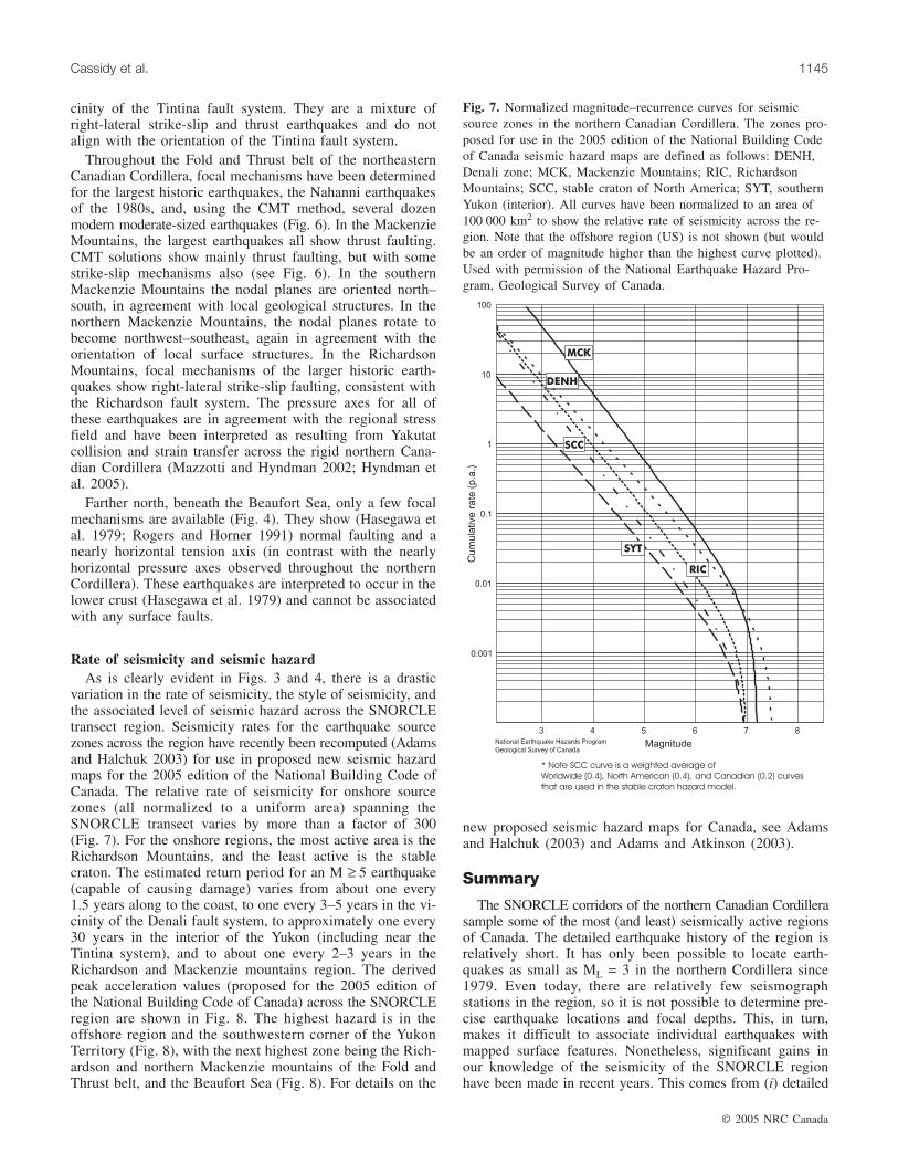
Rate of seismicity and seismic hazardAs is clearly evident in Figs. 3 and 4, there is a drastic
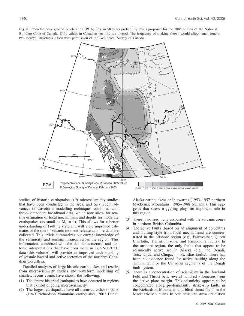
variation in the rate of seismicity, the style of seismicity, andthe associated level of seismic hazard across the SNORCLEtransect region. Seismicity rates for the earthquake sourcezones across the region have recently been recomputed (Adamsand Halchuk 2003) for use in proposed new seismic hazardmaps for the 2005 edition of the National Building Code ofCanada. The relative rate of seismicity for onshore sourcezones (all normalized to a uniform area) spanning theSNORCLE transect varies by more than a factor of 300(Fig. 7). For the onshore regions, the most active area is theRichardson Mountains, and the least active is the stablecraton. The estimated return period for an M ≥ 5 earthquake(capable of causing damage) varies from about one every1.5 years along to the coast, to one every 3–5 years in the vi-cinity of the Denali fault system, to approximately one every30 years in the interior of the Yukon (including near theTintina system), and to about one every 2–3 years in theRichardson and Mackenzie mountains region. The derivedpeak acceleration values (proposed for the 2005 edition ofthe National Building Code of Canada) across the SNORCLEregion are shown in Fig. 8. The highest hazard is in theoffshore region and the southwestern corner of the YukonTerritory (Fig. 8), with the next highest zone being the Rich-ardson and northern Mackenzie mountains of the Fold andThrust belt, and the Beaufort Sea (Fig. 8). For details on the
new proposed seismic hazard maps for Canada, see Adamsand Halchuk (2003) and Adams and Atkinson (2003).
Summary
The SNORCLE corridors of the northern Canadian Cordillerasample some of the most (and least) seismically active regionsof Canada. The detailed earthquake history of the region isrelatively short. It has only been possible to locate earth-quakes as small as ML = 3 in the northern Cordillera since1979. Even today, there are relatively few seismographstations in the region, so it is not possible to determine pre-cise earthquake locations and focal depths. This, in turn,makes it difficult to associate individual earthquakes withmapped surface features. Nonetheless, significant gains inour knowledge of the seismicity of the SNORCLE regionhave been made in recent years. This comes from (i) detailed
© 2005 NRC Canada
Cassidy et al. 1145
Fig. 7. Normalized magnitude–recurrence curves for seismicsource zones in the northern Canadian Cordillera. The zones pro-posed for use in the 2005 edition of the National Building Codeof Canada seismic hazard maps are defined as follows: DENH,Denali zone; MCK, Mackenzie Mountains; RIC, RichardsonMountains; SCC, stable craton of North America; SYT, southernYukon (interior). All curves have been normalized to an area of100 000 km2 to show the relative rate of seismicity across the re-gion. Note that the offshore region (US) is not shown (but wouldbe an order of magnitude higher than the highest curve plotted).Used with permission of the National Earthquake Hazard Pro-gram, Geological Survey of Canada.
studies of historic earthquakes, (ii) microseismicity studiesthat have been conducted in the area, and (iii) recent ad-vances in waveform modelling techniques combined withthree-component broadband data, which now allow for rou-tine estimation of focal mechanisms and depths for moderateearthquakes (as small as ML = 4). This allows for a betterunderstanding of faulting style and will yield improved esti-mates of the rate of seismic moment release as more data arecollected. This article summarizes our current knowledge ofthe seismicity and seismic hazards across the region. Thisinformation, combined with the detailed structural and tec-tonic interpretations that have been made using SNORCLEdata (this volume), will provide an improved understandingof seismic hazard and active tectonics of the northern Cana-dian Cordillera.
Detailed analyses of large historic earthquakes and resultsfrom microseismicity studies and waveform modelling ofsmaller, recent events have shown the following:(1) The largest historical earthquakes have occurred in regions
that exhibit ongoing microseismicity.(2) The largest earthquakes have all occurred either in pairs
(1940 Richardson Mountains earthquakes, 2002 Denali
Alaska earthquakes) or in swarms (1953–1957 northernMackenzie Mountains, 1985–1988 Nahanni). This sug-gests that stress triggering plays an important role inthis region.
(3) There is no seismicity associated with the volcanic zonesin northern British Columbia.
(4) The active faults (based on an alignment of epicentresand faulting style from focal mechanisms) are concen-trated in the offshore region (e.g., Fairweather, QueenCharlotte, Transition zone, and Pampolona faults). Inthe onshore region, the only faults that appear to beseismically active are in Alaska (e.g., the Denali,Totschunda, and Chugach – St. Elias faults). There hasbeen no evidence found for active faulting along theTintina fault or the Canadian segments of the Denalifault system.
(5) There is a concentration of seismicity in the forelandFold and Thrust belt, several hundred kilometres fromthe active plate margin. This seismicity appears to beconcentrated along predominantly strike-slip faults inthe Richardson Mountains and blind thrust faults in theMackenzie Mountains. In both areas, the stress orientation
© 2005 NRC Canada
1146 Can. J. Earth Sci. Vol. 42, 2005
Fig. 8. Predicted peak ground acceleration (PGA) (2% in 50 years probability level) proposed for the 2005 edition of the NationalBuilding Code of Canada. Only values in Canadian territory are plotted. The frequency of shaking shown would affect small (one ortwo storeys) structures. Used with permission of the Geological Survey of Canada.
suggests that earthquakes are triggered by the regionalstress field along optimally aligned faults (see Hyndmanet al. 2005).
Although seismicity cannot be attributed to specific onshorefaults in the northern Canadian Cordillera, the rate of activityis still very significant. On average, M ≥ 5 (potentially dam-aging) earthquakes can be expected every 2–3 years in theRichardson Mountains region and every 3–5 years in thesouthwest corner of the Yukon. The Mw = 7.9 Denali, Alaska,earthquake was a good reminder that the effects of a largeearthquake can be very substantial, even at distances of hun-dreds of kilometres from the earthquake source. It is detailedstudies of seismicity, earth structure, and tectonics, the lattermade possible in large part by the SNORCLE transect, thatwill allow for informed decision-making for resource devel-opment and the design of safe structures and infrastructurein the northern Canadian Cordillera.
Acknowledgments
We thank Phil Hammer for providing information andmaps on the SNORCLE lines, Stephen Halchuk for providingFigs. 7 and 8, and Robert Kung for assisting with Fig. 1.Other figures were generated using Generic Mapping Tools(Wessel and Smith 1995). This manuscript was improved byreviews and comments provided by Allison Bent, Ron Clowes,Diane Doser, and Elizabeth Hearn.
References
Adams, J., and Atkinson, G. 2003. Development of seismic hazardmaps for the proposed 2005 edition of the National BuildingCode of Canada. Canadian Journal of Civil Engineering, 30:255–271.
Adams, J., and Halchuk, S. 2003. Fourth generation seismic hazardmaps of Canada: values for over 650 Canadian localities for the2005 National Building Code of Canada. Geological Survey ofCanada, Open File 4459.
Ammon, C.J. 2001. Moment–tensor inversion overview [online].Available from http://www.essc.psu.edu/~ammon/HTML/MTinvDocs/mtinv01.html [last modified 31 July 2001].
Basham, P.W., Forsyth, D.A., and Wetmiller, R.J. 1977. The seis-micity of northern Canada. Canadian Journal of Earth Sciences,14: 1646–1667.
Cassidy, J.F., and Bent, A.L. 1993. Source parameters of the 29May and 5 June 1940 Richardson Mountains, Yukon Territory,earthquakes. Bulletin of the Seismological Society of America,83: 636–659.
Cassidy, J.F., and Rogers, G.C. 2004. The Mw 7.9 Denali faultearthquake of 3 November 2002: felt reports and unusual effectsacross western Canada. Bulletin of the Seismological Society ofAmerica, 94: S53–S57.
Cassidy, J.F., Schmitt, S., and Bent, A.L. 2002. The 1953–1957Mackenzie Mountains earthquake sequence. Seismological Re-search Letters, 73: 221.
Doser, D.I., and Lomas, R. 2000. The transition from strike-slipfaulting to oblique subduction in southeastern Alaska from seis-mological studies. Tectonophysics, 316: 45–65.
Drysdale, J.A., and Horner, R.B. 1986. Canadian earthquakes —1983. Earth Physics Branch, Seismological Series 93, 56 p.
Eberhart-Phillips, D., Haeussler, P.J., Freymueller, J.T., et al. 2003.The 2002 Denali fault earthquake, Alaska: a large magnitude,slip-portioned event. Science (Washington, D.C.), 300: 1113–1118.
Evans, S.G., Aitken, J.D., Wetmiller, R.J., and Horner, R.B. 1987.A rock avalanche triggered by the October 1985 North Nahanniearthquake, District of Mackenzie, N.W.T. Canadian Journal ofEarth Sciences, 24: 176–184.
Gabrielse, H. 1985. Major dextral transcurrent displacements alongthe northern Rocky Mountain Trench and related lineaments innorth-central British Columbia. Geological Society of AmericaBulletin, 96: 1–14.
Hasegawa, H.S., Chou, C.W., and Basham, P.W. 1979. Seismo-tectonics of the Beaufort Sea. Canadian Journal of Earth Sci-ences, 16: 816–830.
Horner, R.B. 1983. Seismicity in the St. Elias region of northwesternCanada and southeastern Alaska. Bulletin of the SeismologicalSociety of America, 73: 1117–1137.
Horner, R.B. 1989. Low-level seismic monitoring at the WindyCraggy deposit in northwest British Columbia. In Current research,part E. Geological Survey of Canada, Paper 89-1E, pp. 275–278.
Horner, R.B., Galley, C., and Drysdale, J. 1982 Low-level seismicmonitoring in the southwest Yukon Territory. Earth Physics Branch,Open-File Report 82-32.
Horner, R.B., Wetmiller, R.J., Lamontagne, M., and Plouffe, M.1990. A fault model for the Nahanni earthquakes from after-shock studies. Bulletin of the Seismological Society of America,80: 1553–1570.
Hyndman, R.D., Flück, P., Mazzotti, S., Lewis, T., Ristau, J., andLeonard, L. 2005. Current tectonics of the northern CanadianCordillera. Canadian Journal of Earth Sciences, 42: this issue.
Irving, E., Wynne, P.J., Thorkelson, D.J., and Schiarizza, P. 1996.Large (1000–4000) northward movements of tectonic domainsin the northern Cordillera, 83 to 45 Ma. Journal of GeophysicalResearch, 101: 17 901 – 17 916.
Jackson, L.E., Jr. 1990. Oldest dated earthquake in Yukon Territory,Canada. Canadian Journal of Earth Sciences, 27: 818–819.
Leblanc, G., and Wetmiller, R.J. 1974. An evaluation of seismologicaldata available for the Yukon Territory and the Mackenzie Valley.Canadian Journal of Earth Sciences, 11: 1435–1454.
Mazzotti, S., and Hyndman, R.D. 2002. Yukutat collision and straintransfer across the northern Canadian Cordillera. Geology, 30:495–498.
Milne, W.G., Smith, W.E.T., and Rogers, G.C. 1970. Canadianseismicity and microearthquake research in Canada. CanadianJournal of Earth Sciences, 7: 1–11.
Moon, W.M., Won, J.S., Li, B., Slaney, V.R., and Lamontagne, M.1991. Application of air-borne C-SAR and SPOT image data tothe geological setting of the Nahanni earthquake area. CanadianJournal of Remote Sensing, 17: 272–278.
Moon, W.M., Ristau, J., and Vachon, P. 1998. Feasibility of applyingspace-borne SAR interferometry for earthquake tectonic investi-gation. Geoscience Journal, 2: 78–87.
Plafker, G. 1987. Regional geology and petroleum potential of thenorthern Gulf of Alaska continental margin. In Geology andresource potential of the continental margin of western NorthAmerica and adjacent ocean basins — Beaufort Sea to BajaCalifornia. Edited by D.W. Scholl, A. Grantz, and J.G. Vedder.Earth Sciences Series 6. Circum-Pacific Council for Energy andMineral Resources, Houston, Tex., pp. 229–268.
Plafker, G., Hudson, T., and Richter, D.H. 1977. Preliminary obser-vations on late Cenozoic displacements along the Totschundaand Denali fault systems. In The United States Geological Surveyin Alaska: accomplishments during 1976. Edited by K.M. Blean.US. Geological Survey, Circular 751-B, pp. 67–69.
Plafker, G., Moore, J.C., and Winkler, G.R. 1994a. Geology of thesouthern Alaska margin. In The geology of Alaska. Edited by
© 2005 NRC Canada
Cassidy et al. 1147
G. Plafker and H.C. Berg. Geological Society of America, Geol-ogy of North America, Vol. G1, pp. 251–261.
Plafker, G., Gilpin, L., and Lahr, J. 1994b. Plate 12. In The geologyof Alaska. Edited by G. Plafker and H.C. Berg. Geological Societyof America, Geology of North America, Vol. G1, pp. 251–261.
Ratchkovski, N.A., and Hansen, R.A. 2002. New constraints ontectonics of interior Alaska: earthquake locations, source mecha-nisms, and stress regime. Bulletin of the Seismological Societyof America, 92: 998–1014.
Richter, D.H., and Matson, N.A., Jr. 1971. Quaternary faulting inthe eastern Alaska Range. Bulletin of the Geological Society ofAmerica, 82: 1529–1540.
Ristau, J., Rogers, G.C., and Cassidy, J.F. 2003. Moment magnitude —local magnitude calibration for earthquakes off Canada’s westcoast. Bulletin of the Seismological Society of America, 93:2296–2300.
Roddick, J.A. 1967. Tintina Trench. Journal of Geology, 75: 468–471.Rogers, G.C. 1976. A microearthquake survey in northwest British
Columbia and southeast Alaska. Bulletin of the SeismologicalSociety of America, 66: 1643–1655.
Rogers, G.C., and Horner, R.B. 1991. An overview of westernCanadian seismicity. In Neotectonics of North America. Edited byD.B. Slemmons, E.R. Engdahl, M.D. Zoback, and D.D. Blackwell.Geological Society of America, Geology of North America, De-cade Map, Vol. 1, pp. 69–76.
Snyder, D.B., Clowes, R.M., Cook, F.A., Erdmer, F.A., Evenchick,C.A., van der Velden, A.J., and Hall, K.W. 2002. Proterozoicprism arrests suspect terranes: insights into the ancient Cordilleranmargin from seismic reflection data. GSA Today, 12: 4–10.
Weichert, D.H., Wetmiller, R.J., and Munro, P.S. 1986. Verticalearthquake accelerations exceeding 1G? The case of the missingpeak. Bulletin of the Seismological Society of America, 76:1473–1478.
Welford, J.K., Clowes, R.M., Ellis, R.M., Spence, G.D., Asudeh, I.,and Hajnal, Z. 2001. Lithospheric structure across the craton–Cordilleran transition of northeastern British Columbia. CanadianJournal of Earth Sciences, 38: 1169–1189.
Wessel, P., and Smith, W.H.F. 1995. New version of GenericMapping Tools released. EOS, 76: 329.
Wetmiller, R.J., Horner, R.B., Hasegawa, H.S., North, R.G.,Lamontagne, M., Weichert, D.H., and Evans, S.G. 1988. Ananalysis of the 1985 Nahanni earthquakes. Bulletin of the Seis-mological Society of America, 78: 590–616.
Wheeler, J.O., and McFeely, P. 1991. Tectonic assemblage map ofthe Canadian Cordillera and adjacent parts of the United Statesof America. Geological Survey of Canada, Map 1712A, scale1 : 2 000 000.
© 2005 NRC Canada
1148 Can. J. Earth Sci. Vol. 42, 2005