Embed Size (px)
Citation preview

Ref: GL-15-02-12-GMD-000178.docx
13 February 2015 The Directors Ayrburn Farms Development Ltd C/- Winton Partners Investments Ltd Email: [email protected] Attention: Andrew Cavill Dear Andrew Ayrburn Farms Residential Development Concept – Flood Hazard Mitigation
1.0 Introduction
We refer to the Winton Partners Limited email from Chris Meehan to Fluent Solutions dated 12 February 2015 and the attached Baxter Design Group “Ayrburn - Draft Concept” drawing dated 12 February 2015 prepared for Ayrburn Farm Developments Limited. Part of the proposed Ayrburn development would lie within an area described in the Queenstown Lakes District Council GIS based Hazard Register data as being within an area referred to as “Flood Hazard due to rainfall” resulting from flows that pass down Mill Stream that traverses Ayrburn farm. The Flood Hazard area is shown in Figure 1 below (Page 2). A preliminary assessment of the mitigation requirements has been addressed below.
2.0 Background
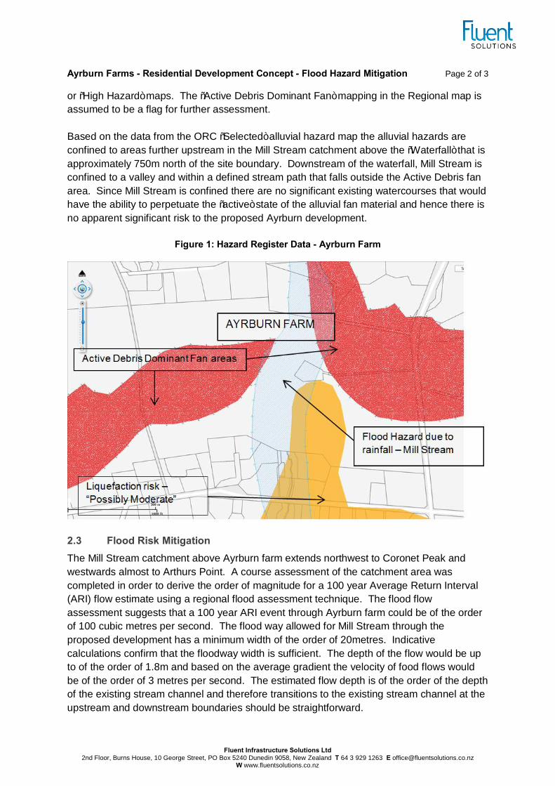
2.1 Ayrburn Farm Hazard Data Three hazards have been identified in Figure 1 below that fall within the Ayrburn farm site. These are:
1. Flood Hazard due to rainfall - addressed below
2. Alluvial fan hazard - “Active Debris Dominant Fan” areas - addressed below
3. “Liquefaction risk - Possibly Moderate” - assumed to be addressed by others in due course.
2.2 Alluvial Fan Risk Reference to an “Active Debris Dominant Fan” hazard on the site outside of the flood hazard area is referred to in the Otago Regional Council (ORC) “Regional” alluvial fan hazard map but no reference to an alluvial fan hazard is mapped on Ayrburn farm in the “Selected Area”
Ayrburn Farms - Residential Development Concept - Flood Hazard Mitigation Page 2 of 3
Fluent Infrastructure Solutions Ltd 2nd Floor, Burns House, 10 George Street, PO Box 5240 Dunedin 9058, New Zealand T 64 3 929 1263 E [email protected]
W www.fluentsolutions.co.nz
or “High Hazard” maps. The “Active Debris Dominant Fan” mapping in the Regional map is assumed to be a flag for further assessment. Based on the data from the ORC “Selected” alluvial hazard map the alluvial hazards are confined to areas further upstream in the Mill Stream catchment above the “Waterfall” that is approximately 750m north of the site boundary. Downstream of the waterfall, Mill Stream is confined to a valley and within a defined stream path that falls outside the Active Debris fan area. Since Mill Stream is confined there are no significant existing watercourses that would have the ability to perpetuate the “active” state of the alluvial fan material and hence there is no apparent significant risk to the proposed Ayrburn development.
Figure 1: Hazard Register Data - Ayrburn Farm
2.3 Flood Risk Mitigation The Mill Stream catchment above Ayrburn farm extends northwest to Coronet Peak and westwards almost to Arthurs Point. A course assessment of the catchment area was completed in order to derive the order of magnitude for a 100 year Average Return Interval (ARI) flow estimate using a regional flood assessment technique. The flood flow assessment suggests that a 100 year ARI event through Ayrburn farm could be of the order of 100 cubic metres per second. The flood way allowed for Mill Stream through the proposed development has a minimum width of the order of 20metres. Indicative calculations confirm that the floodway width is sufficient. The depth of the flow would be up to of the order of 1.8m and based on the average gradient the velocity of food flows would be of the order of 3 metres per second. The estimated flow depth is of the order of the depth of the existing stream channel and therefore transitions to the existing stream channel at the upstream and downstream boundaries should be straightforward.

Ayrburn Farms - Residential Development Concept - Flood Hazard Mitigation Page 3 of 3
Fluent Infrastructure Solutions Ltd 2nd Floor, Burns House, 10 George Street, PO Box 5240 Dunedin 9058, New Zealand T 64 3 929 1263 E [email protected]
W www.fluentsolutions.co.nz
The floodway would be designed to account for the flow velocities and for protection of building floor levels in adjacent properties according to Council’s Code of Practice for land development. The protection of floor levels requires attention to the freeboard in the channel to ensure the design event is safely confined without causing property damage. The estimated flow velocity means that the channel design would need to account for erosion and sedimentation processes. This means the channel is expected to require a combination of rock protection, proprietary erosion control and planting treatments to mitigate potentially significant erosion effects.
3.0 Conclusion
Based on the assessment above, the potential flood effects on the proposed development can be mitigated within the proposed Mill Stream conveyance corridor shown in the attached Ayrburn - Draft Concept drawing. Yours faithfully FLUENT INFRASTRUCTURE SOLUTIONS LTD Per:
Gary Dent Senior Environmental Engineer CPEng / IntPE Attachment:
§ Baxter Design Group “Ayrburn - Draft Concept” Drawing dated 12 February 2015 (1page)

Farmers market space (gravel areas, note - closed to vehicles aside from market days)
Central ‘village greens’
Housing: design controls to restrict building forms to Arrowtown vernacular - gables, stone, weatherboard
Historic farm centre maintained & preserved as heart of site
Outdoor area around cafe
Setback & screening area
Mill Stream esplanade reserve access walkway
Managers house & farm sheds
Visible open space maintained as existing
Potential retail area - garden centre or similar
Existing homestead maintained on separate access & title
Dwellings located in lower terrace areas - screened from road by landforms
Access from Lakes Hayes - Arrowtown Road in avenue form - no kerb & channel
Open visible paddocks protected & maintained
AYRBURN - DRAFT CONCEPTAYRBURN FARM DEVELOPMENTS LTD BDG REF: 2514-SK05 - SCALE = 1:3000 T A3 - 12 FEB 2015
+