Embed Size (px)
Citation preview
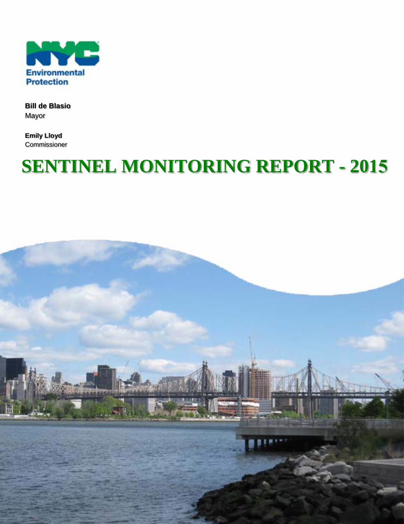
Bill de Blasio Mayor Emily Lloyd Commissioner
SENTINEL MONITORING REPORT - 2015
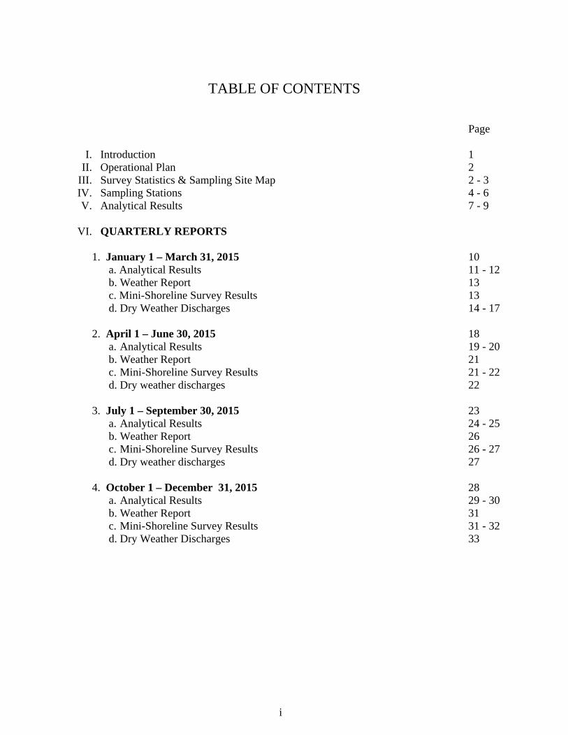
TABLE OF CONTENTS
Page
I. Introduction 1 II. Operational Plan 2
III. Survey Statistics & Sampling Site Map 2 - 3 IV. Sampling Stations 4 - 6 V. Analytical Results 7 - 9
VI. QUARTERLY REPORTS
1. January 1 – March 31, 2015 10
a. Analytical Results 11 - 12 b. Weather Report 13 c. Mini-Shoreline Survey Results 13 d. Dry Weather Discharges 14 - 17
2. April 1 – June 30, 2015 18
a. Analytical Results 19 - 20 b. Weather Report 21 c. Mini-Shoreline Survey Results 21 - 22 d. Dry weather discharges 22
3. July 1 – September 30, 2015 23
a. Analytical Results 24 - 25 b. Weather Report 26 c. Mini-Shoreline Survey Results 26 - 27 d. Dry weather discharges 27
4. October 1 – December 31, 2015 28
a. Analytical Results 29 - 30 b. Weather Report 31 c. Mini-Shoreline Survey Results 31 - 32 d. Dry Weather Discharges 33
i

INTRODUCTION The Shoreline Survey Program-Cycle II conducted by the Bureau of Wastewater Treatment’s Compliance Monitoring Section (CMS) between 1998 and 2015 has resulted in the identification of 4,406 outfalls including 427 Combined Sewer Overflows (CSO), 375 storm outfalls and other outfalls such as highway drains and non-city owned drains. A total of 388 contaminated discharges representing a flow of 4.16 MGD were identified. Since then, 369 of these contaminated discharges have been abated, representing a flow of 4.10 MGD, of which 238 discharging pipes are city-owned and the remainder, 131, falls under the jurisdiction of NYSDEC. Currently NYCDEP has six (6) contaminated discharge pipes under abatement investigation, or 0.04 MGD, whereas 8 sewer pipes under the jurisdiction of NYSDEC remain to be abated or 0.02 MGD. Therefore, the benefit has been a 98.6 % abatement rate of contaminated dry weather discharges.
As an enhancement and modification of surveying the City’s coastal waters under the Shoreline Survey Program, a “SENTINEL MONITORING PROGRAM” was designed, in cooperation with NYSDEC, to monitor specific sampling areas for fecal coliform (a raw sewage indicator) in water bodies throughout New York City. NYCDEP currently performs sentinel monitoring at eighty ambient monitoring stations in accordance with the current SPDES permit. When a survey of the shoreline is performed, all shoreline survey protocols described in the Untreated Discharges section of the SPDES permit are followed. The goal of the Sentinel Monitoring Program is the periodic monitoring and sampling of ambient stations throughout New York City’s harbor. Quarterly fecal coliform sampling is conducted at eighty stations. Sampling is performed after a dry antecedent period of forty eight hours and during various tidal cycles and seasons to ensure statistical integrity. The sampling results are compared to an established baseline. If sampling results are above the baseline trigger limits, NYCDEP aggressively pursues field investigations and surveillance of the adjacent shoreline of such sentinel stations to determine the source and cause of the contamination. Immediate actions are implemented to abate any found illegal discharges
1
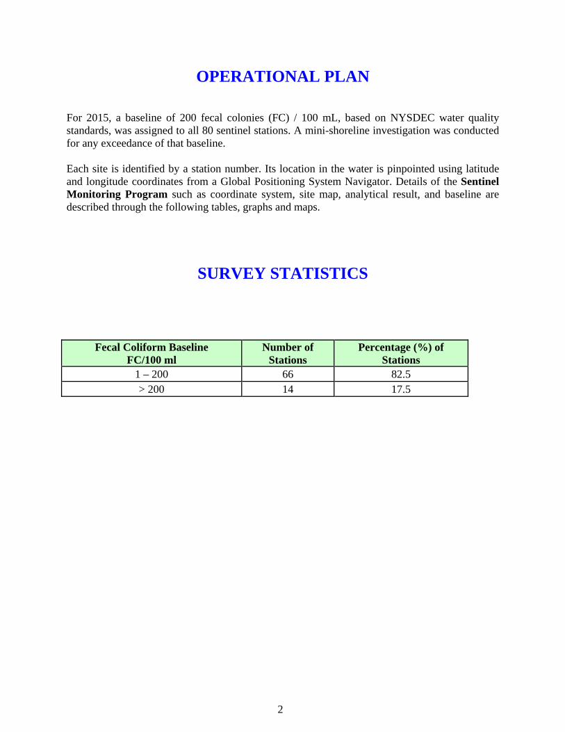
OPERATIONAL PLAN For 2015, a baseline of 200 fecal colonies (FC) / 100 mL, based on NYSDEC water quality standards, was assigned to all 80 sentinel stations. A mini-shoreline investigation was conducted for any exceedance of that baseline. Each site is identified by a station number. Its location in the water is pinpointed using latitude and longitude coordinates from a Global Positioning System Navigator. Details of the Sentinel Monitoring Program such as coordinate system, site map, analytical result, and baseline are described through the following tables, graphs and maps.
SURVEY STATISTICS
Fecal Coliform Baseline FC/100 ml
Number of Stations
Percentage (%) of Stations
1 – 200 66 82.5 > 200 14 17.5
2

$ 1
$ 1
$ 1
$ 1
$ 1
$ 1
$ 1
$ 1
$ 1
$ 1 $ 1
$ 1
$ 1
$ 1
$ 1
$ 1
$ 1
$ 1$ 1
$ 1
$ 1
$ 1
$ 1$ 1
$ 1 $ 1
$ 1
$ 1
$ 1
$ 1$ 1$ 1 $ 1
$ 1
$ 1
$ 1
$ 1
$ 1
$ 1 $ 1
$ 1
$ 1
$ 1
$ 1
$ 1
$ 1
$ 1$ 1$ 1
$ 1 $ 1
$ 1 $ 1
$ 1
$ 1$ 1
$ 1$ 1$ 1
$ 1
$ 1$ 1$ 1
$ 1$ 1
$ 1 $ 1$ 1
$ 1 $ 1$ 1
$ 1
$ 1
$ 1
$ 1
$ 1
$ 1$ 1
$ 1
$ 1
S47
S48
S49
S50
S51
S52
S53
S54
S55
S56 S57 S5
8
S59
S60
S61
S62
S63
S64
S65 S6
6
S67
S68
S69
S70
S71
S72
S73
S74
S75S7
6S7
7S78
S79
S80
S1S2
S3
S4
S5 S6
S7
S8S9
S10
S11 S1
2
S13
S14
S15
S16
S17
S18
S19
S20
S21
S22
S23
S24
S25
S26
S27S2
8S29
S30
S31
S32 S33
S34
S35
S36
S37
S38
S39
S40
S41
S42
S43
S44
S45
S46
$ 11 -
200
$ 1> 2
01New
Yor
k H
arbo
r Se
ntin
el M
onit
orin
g St
atio
nsN
ew Y
ork
Har
bor
Sent
inel
Mon
itor
ing
Stat
ions
2015
- S
urve
y St
atis
tics
2015
- S
urve
y St
atis
tics
03
69
121.5
Miles
Ü
S61 :
2,98
6S7
: 70
4S6
0 : 54
6S4
9 : 45
4
S6 :
1850
S13 :
1647
S14 :
563
S77 :
349
S78 :
7,52
2
S74 :
475
S46 :
731
S62 :
949
S80:
202
S76 :
314
3
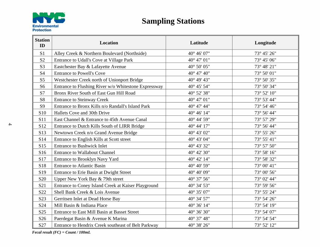
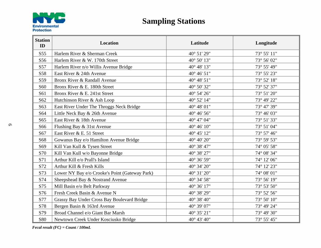
Station ID Location Latitude Longitude
S1 Alley Creek & Northern Boulevard (Northside) 40° 46' 07" 73° 45' 26" S2 Entrance to Udall's Cove at Village Park 40° 47' 01" 73° 45' 06" S3 Eastchester Bay & Lafayette Avenue 40° 50' 05" 73° 48' 21" S4 Entrance to Powell's Cove 40° 47' 40" 73° 50' 01" S5 Westchester Creek north of Unionport Bridge 40° 49' 43" 73° 50' 35" S6 Entrance to Flushing River w/o Whitestone Expressway 40° 45' 54" 73° 50' 34" S7 Bronx River South of East Gun Hill Road 40° 52' 38" 73° 52' 10" S8 Entrance to Steinway Creek 40° 47' 01" 73° 53' 44" S9 Entrance to Bronx Kills n/o Randall's Island Park 40° 47' 44" 73° 54' 46" S10 Hallets Cove and 30th Drive 40° 46' 14" 73° 56' 44" S11 East Channel & Entrance to 45th Avenue Canal 40° 44' 59" 73° 57' 29" S12 Entrance to Dutch Kills South of LIRR Bridge 40° 44' 17" 73° 56' 44" S13 Newtown Creek n/o Grand Avenue Bridge 40° 43' 02" 73° 55' 26" S14 Entrance to English Kills at Scott street 40° 43' 04" 73° 55' 41" S15 Entrance to Bushwick Inlet 40° 43' 32" 73° 57' 50" S16 Entrance to Wallabout Channel 40° 42' 30" 73° 58' 16" S17 Entrance to Brooklyn Navy Yard 40° 42' 14" 73° 58' 32" S18 Entrance to Atlantic Basin 40° 40' 59" 73° 00' 41" S19 Entrance to Erie Basin at Dwight Street 40° 40' 09" 73° 00' 56" S20 Upper New York Bay & 79th street 40° 37' 56" 73° 02' 44" S21 Entrance to Coney Island Creek at Kaiser Playground 40° 34' 53" 73° 59' 56" S22 Shell Bank Creek & Lois Avenue 40° 35' 07" 73° 55' 24" S23 Gerritsen Inlet at Dead Horse Bay 40° 34' 57" 73° 54' 26" S24 Mill Basin & Indiana Place 40° 36' 14" 73° 54' 19" S25 Entrance to East Mill Basin at Basset Street 40° 36' 30" 73° 54' 07" S26 Paerdegat Basin & Avenue K Marina 40° 37' 48" 73° 54' 54" S27 Entrance to Hendrix Creek southeast of Belt Parkway 40° 38' 26" 73° 52' 12"
Fecal result (FC) = Count / 100mL
Sampling Stations
4

Station ID Location Latitude Longitude
S28 Entrance to Shellbank Basin at 165th Avenue 40° 38' 59" 73° 50' 13" S29 Entrance to Hawtree Basin at 164th Avenue 40° 39' 02" 73° 49' 52" S30 Grassy Bay at South Runway 7-JFK Airport 40° 37' 55" 73° 47' 59" S31 Entrance to Thurston Basin 40° 38' 18" 73° 44' 52" S32 Entrance to Mott Basin at Breeze Place 40° 36' 53" 73° 46' 11" S33 Entrance to Norton Basin at Dunbar Street 40° 36' 29" 73° 46' 21" S34 Entrance to Sommerville Basin 40° 36' 11" 73° 47' 08" S35 Entrance to Vernam Basin at Alameda Avenue 40° 35' 44" 73° 48' 18" S36 Entrance to Barbadoes Basin at Beach 83rd Street 40° 35' 35" 73° 48' 29" S37 Beach Channel and Beach 131st Street 40° 35' 08" 73° 51' 23" S38 Bannister Creek & Atlantic Beach Bridge Approach 40° 35' 50" 73° 44' 19" S39 Upper NY Bay &Navy Homeport (at Union Street) 40° 37' 46" 74° 03' 56" S40 Lower NY Bay n/o Sand Lane (South Beach) 40° 34' 28" 74° 04' 40" S41 Lower NY Bay s/o New Dorp Lane (Gateway Park) 40° 33' 42" 74° 05' 28" S42 Entrance to Great Kills Harbor at Cleveland Avenue 40° 32' 13" 74° 08' 22" S43 Raritan Bay n/o Huguenot Avenue 40° 31' 01" 74° 10' 48" S44 Prince's Bay& entrance to Lemon Creek 40° 30' 40" 74° 12' 05" S45 Arthur Kill & Entrance to Mill Creek 40° 31' 16" 74° 14' 43" S46 Richmond Creek and Richmond Avenue (Eastside) 40° 33' 59" 74° 10' 12" S47 Hudson River & W.233rd Street 40° 54' 11" 73° 54' 56" S48 Hudson River Under George Washington Bridge 40° 51' 04" 73° 56' 58" S49 Hudson River & W.135th Street 40° 49' 25" 73° 57' 38" S50 Hudson River & W. 86th Street 40° 47' 34" 73° 58' 59" S51 Hudson River & W. 38th Street 40° 45' 41" 73° 00' 19" S52 Hudson River & W. 14th Street 40° 44' 41" 73° 00' 46" S53 Hudson River & South Cove (The Battery) 40° 42' 26" 73° 01' 10" S54 Harlem River Under Broadway Bridge 40° 52' 25" 73° 54' 40"
Fecal result (FC) = Count / 100mL
Sampling Stations
5
Station ID Location Latitude Longitude
S55 Harlem River & Sherman Creek 40° 51' 29" 73° 55' 11" S56 Harlem River & W. 170th Street 40° 50' 13" 73° 56' 02" S57 Harlem River n/o Willis Avenue Bridge 40° 48' 13" 73° 55' 49" S58 East River & 24th Avenue 40° 46' 51" 73° 55' 23" S59 Bronx River & Randall Avenue 40° 48' 51" 73° 52' 18" S60 Bronx River & E. 180th Street 40° 50' 32" 73° 52' 37" S61 Bronx River & E. 241st Street 40° 54' 26" 73° 51' 20" S62 Hutchinson River & Ash Loop 40° 52' 14" 73° 49' 22" S63 East River Under The Throggs Neck Bridge 40° 48' 01" 73° 47' 39" S64 Little Neck Bay & 26th Avenue 40° 46' 56" 73° 46' 03" S65 East River & 18th Avenue 40° 47' 04" 73° 51' 33" S66 Flushing Bay & 31st Avenue 40° 46' 10" 73° 51' 04" S67 East River & E. 51 Street 40° 45' 12" 73° 57' 46" S68 Gowanus Bay e/o Hamilton Avenue Bridge 40° 40' 20" 73° 59' 53" S69 Kill Van Kull & Tysen Street 40° 38' 47" 74° 05' 58" S70 Kill Van Kull w/o Bayonne Bridge 40° 38' 27" 74° 08' 34" S71 Arthur Kill e/o Prall's Island 40° 36' 59" 74° 12' 06" S72 Arthur Kill & Fresh Kills 40° 34' 20" 74° 12' 23" S73 Lower NY Bay e/o Crooke's Point (Gateway Park) 40° 31' 20" 74° 08' 01" S74 Sheepshead Bay & Nostrand Avenue 40° 34' 58" 73° 56' 19" S75 Mill Basin e/o Belt Parkway 40° 36' 17" 73° 53' 50" S76 Fresh Creek Basin & Avenue N 40° 38' 29" 73° 52' 56" S77 Grassy Bay Under Cross Bay Boulevard Bridge 40° 38' 40" 73° 50' 10" S78 Bergen Basin & 163rd Avenue 40° 39' 07" 73° 49' 24" S79 Broad Channel e/o Giant Bar Marsh 40° 35' 21" 73° 49' 30" S80 Newtown Creek Under Kosciusko Bridge 40° 43' 40" 73° 55' 45"
Fecal result (FC) = Count / 100mL
Sampling Stations
6

Station ID Samp1 Samp2 Samp3 Samp4 Samp5 Samp6 Samp7 Samp8 Samp9 Samp10 95% UCL
S1 1,800 4,000 10 4 63 83 6 5 25 20 192 S2 2 100 4 4 18 33 6 4 5 20 20 S3 4 6 2 4 10 14 4 4 4 5 7 S4 24 5 1 6 10 14 28 4 18 8 15 S5 12 8 2 4 9 6 11 25 15 264 26 S6 4,000 440 88 700 430 870 3,770 15 2,780 1,400 1,850 S7 520 1,760 620 112 450 260 80 276 1,320 340 704 S8 44 15 1 47 9 22 6 4 8 2 19 S9 60 14 2 19 27 230 11 8 2 4 33 S10 4,000 48 6 35 18 80 14 5 5 8 92 S11 10 26 44 2 36 88 8 20 96 2 41 S12 188 24 1 2 27 990 196 10 22 108 120 S13 380 236 120 16 660 8,200 670 160 3,280 4,000 1,647 S14 700 276 5 44 230 2,500 152 196 380 385 563 S15 8 22 19 32 9 53 14 15 8 5 23 S16 19 26 1 2 9 39 22 4 25 12 21 S17 10 42 8 10 10 84 80 5 5 8 29 S18 8 6 11 5 10 17 8 10 20 4 12 S19 1 1 11 2 10 6 19 2 12 2 8 S20 3,560 10 8 33 9 8 50 5 8 4 65 S21 1,020 5 30 19 9 11 14 88 12 2 57 S22 24 12 2 4 10 11 11 2 2 4 10 S23 20 164 1 4 10 3 4 5 4 4 15 S24 20 2 2 8 59 11 6 4 10 4 14 S25 28 2 2 11 40 11 11 8 2 4 14 S26 288 176 100 84 30 39 58 164 164 307 179 S27 680 106 4 480 10 4 11 5 18 30 86
SHORELINE MONITORING PROGRAM 2016 ANALYTICAL RESULTS
UCL – Under Confidence Limit Fecal result = FC / 100ml
7
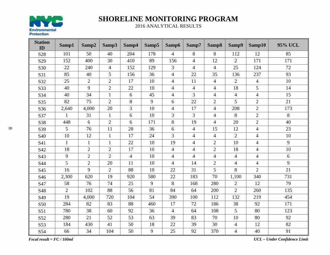
Station ID Samp1 Samp2 Samp3 Samp4 Samp5 Samp6 Samp7 Samp8 Samp9 Samp10 95% UCL
S28 101 50 40 204 178 4 8 8 112 12 85 S29 152 400 30 410 89 156 4 12 2 171 171 S30 22 240 4 152 129 3 4 4 25 124 72 S31 85 40 5 156 36 4 22 35 136 237 93 S32 25 2 2 17 10 4 11 4 2 4 10 S33 40 9 2 22 10 4 4 4 18 5 14 S34 40 34 1 6 45 4 3 4 4 4 15 S35 82 75 2 8 9 6 22 2 5 2 21 S36 2,640 4,000 20 3 10 4 17 4 208 2 173 S37 1 31 1 6 10 3 3 4 8 2 8 S38 448 6 2 6 171 8 19 4 20 2 40 S39 5 76 11 28 36 6 4 15 12 4 23 S40 10 12 1 17 24 3 4 4 2 4 10 S41 1 1 1 22 10 19 4 2 10 4 9 S42 18 2 2 17 10 4 4 2 18 4 10 S43 9 2 2 4 10 4 4 4 4 4 6 S44 5 2 20 11 10 4 14 2 4 4 9 S45 16 9 2 88 10 22 31 5 8 2 21 S46 2,300 620 19 920 580 22 183 70 1,100 340 731 S47 58 76 74 25 9 8 168 280 2 12 79 S48 2 102 88 56 81 84 64 200 2 260 135 S49 19 4,000 720 104 54 390 100 112 132 219 454 S50 284 82 83 88 460 17 72 186 38 92 171 S51 780 38 60 92 36 4 64 108 5 80 123 S52 280 21 52 53 63 39 83 70 10 80 92 S53 184 430 41 50 18 22 39 30 4 12 82 S54 66 34 104 50 9 25 92 370 4 40 91
SHORELINE MONITORING PROGRAM 2016 ANALYTICAL RESULTS
UCL – Under Confidence Limit Fecal result = FC / 100ml
8

Station ID Samp1 Samp2 Samp3 Samp4 Samp5 Samp6 Samp7 Samp8 Samp9 Samp10 95% UCL
S55 68 14 113 80 27 31 168 226 2 35 100 S56 64 14 14 64 162 47 112 136 2 116 101 S57 46 16 18 69 108 6 31 15 2 60 48 S58 99 12 6 8 81 69 8 45 8 4 38 S59 500 64 12 400 117 490 4 80 25 65 199 S60 1,200 620 640 102 520 50 8 220 900 52 546 S61 3,260 2,020 268 204 18,000 3,400 144 560 1,920 1,460 2,986 S62 44 144 2 11 153 96 1,700 2,320 4,000 2,500 949 S63 124 6 2 3 9 4 104 4 4 4 20 S64 660 620 6 4 108 116 4 4 18 8 101 S65 1,240 4,000 4 4 27 31 4 20 30 10 145 S66 4,000 12 4 4 10 8 19 4 18 96 72 S67 800 9 18 81 320 14 8 8 8 5 76 S68 700 18 21 4 162 1,200 31 2 45 12 138 S69 29 31 18 112 9 11 22 8 25 2 32 S70 196 20 42 82 10 6 17 8 8 2 39 S71 48 19 20 113 9 4 14 2 15 2 27 S72 114 26 30 84 18 28 4 5 10 5 37 S73 2 1 2 3 10 3 61 4 12 4 9 S74 840 680 29 174 27 1,600 33 28 1,120 132 475 S75 6 16 1 4 10 4 4 4 15 4 9 S76 2,520 156 168 211 138 25 156 18 188 95 314 S77 160 960 16 900 370 900 44 20 20 58 349 S78 3,500 4,000 1,900 3,200 125,000 12,900 330 253 900 560 7,522 S79 14 119 4 3 90 4 4 2 10 2 20 S80 96 480 4 2 27 176 148 15 600 230 202
SHORELINE MONITORING PROGRAM 2016 ANALYTICAL RESULTS
UCL – Under Confidence Limit Fecal result = FC / 100ml
9
1st QUARTER JANUARY 1 - MARCH 31, 2015
10
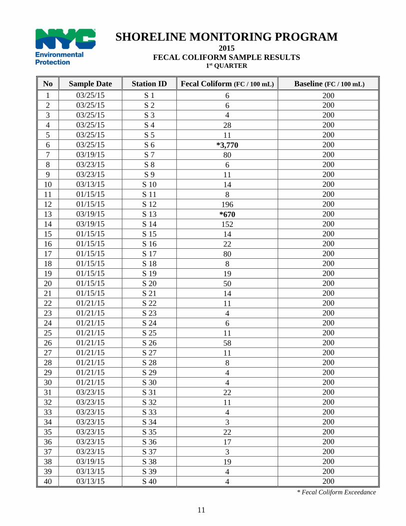
No Sample Date Station ID Fecal Coliform (FC / 100 mL) Baseline (FC / 100 mL) 1 03/25/15 S 1 6 200 2 03/25/15 S 2 6 200 3 03/25/15 S 3 4 200 4 03/25/15 S 4 28 200 5 03/25/15 S 5 11 200 6 03/25/15 S 6 *3,770 200 7 03/19/15 S 7 80 200 8 03/23/15 S 8 6 200 9 03/23/15 S 9 11 200 10 03/13/15 S 10 14 200 11 01/15/15 S 11 8 200 12 01/15/15 S 12 196 200 13 03/19/15 S 13 *670 200 14 03/19/15 S 14 152 200 15 01/15/15 S 15 14 200 16 01/15/15 S 16 22 200 17 01/15/15 S 17 80 200 18 01/15/15 S 18 8 200 19 01/15/15 S 19 19 200 20 01/15/15 S 20 50 200 21 01/15/15 S 21 14 200 22 01/21/15 S 22 11 200 23 01/21/15 S 23 4 200 24 01/21/15 S 24 6 200 25 01/21/15 S 25 11 200 26 01/21/15 S 26 58 200 27 01/21/15 S 27 11 200 28 01/21/15 S 28 8 200 29 01/21/15 S 29 4 200 30 01/21/15 S 30 4 200 31 03/23/15 S 31 22 200 32 03/23/15 S 32 11 200 33 03/23/15 S 33 4 200 34 03/23/15 S 34 3 200 35 03/23/15 S 35 22 200 36 03/23/15 S 36 17 200 37 03/23/15 S 37 3 200 38 03/19/15 S 38 19 200 39 03/13/15 S 39 4 200 40 03/13/15 S 40 4 200
SHORELINE MONITORING PROGRAM 2015
FECAL COLIFORM SAMPLE RESULTS 1st QUARTER
* Fecal Coliform Exceedance
11

No Sample Date Station ID Fecal Coliform (FC / 100 mL) Baseline (FC / 100 mL) 41 03/13/15 S 41 4 200 42 03/13/15 S 42 4 200 43 03/13/15 S 43 4 200 44 03/13/15 S 44 14 200 45 03/13/15 S 45 31 200 46 03/19/15 S 46 183 200 47 03/24/15 S 47 168 200 48 03/24/15 S 48 64 200 49 03/24/15 S 49 100 200 50 03/24/15 S 50 72 200 51 03/24/15 S 51 64 200 52 03/24/15 S 52 83 200 53 03/24/15 S 53 39 200 54 03/24/15 S 54 92 200 55 03/24/15 S 55 168 200 56 03/24/15 S 56 112 200 57 03/24/15 S 57 31 200 58 03/13/15 S 58 8 200 59 03/25/15 S 59 4 200 60 03/19/15 S 60 8 200 61 03/19/15 S 61 144 200 62 03/19/15 S 62 *1,700 200 63 03/25/15 S 63 104 200 64 03/25/15 S 64 4 200 65 03/25/15 S 65 4 200 66 03/25/15 S 66 19 200 67 01/15/15 S 67 8 200 68 01/15/15 S 68 31 200 69 03/13/15 S 69 22 200 70 03/13/15 S 70 17 200 71 03/13/15 S 71 14 200 72 03/13/15 S 72 4 200 73 03/13/15 S 73 61 200 74 03/23/15 S 74 33 200 75 01/21/15 S 75 4 200 76 01/21/15 S 76 156 200 77 01/21/15 S 77 44 200 78 01/21/15 S 78 *330 200 79 03/23/15 S 79 4 200 80 01/15/15 S 80 148 200
SHORELINE MONITORING PROGRAM 2015
FECAL COLIFORM SAMPLE RESULTS 1st QUARTER
* Fecal Coliform Exceedance
12

WEATHER REPORT The first quarter monitoring and sampling of ambient sampling stations began on January 01 and ended on March 31, 2015. During this quarter, all eighty sentinel stations were sampled. During this quarter a total of 11.99 inches of precipitation fell.
MINI-SHORELINE SURVEY RESULTS S-6: Entrance to Flushing River, w/o Whitestone Expressway A mini shoreline survey of the Flushing River was conducted in the end of April. The survey covered the shoreline of the river between Roosevelt Avenue and 31st Road. No discharge was observed. S-13: Newtown Creek, n/o Grand Avenue A mini shoreline survey of the Newtown Creek was conducted in the end of April. The survey covered the shoreline of the creek between Grand Avenue and 58th Street. No discharge was observed. S-62: Hutchinson River & Ash Loop A mini shoreline survey of the Hutchinson River was conducted in mid-April. The survey covered the shoreline of the river near Coop City, Bronx. No discharge was observed. S-78: Bergen Basin & 163rd Avenue A mini shoreline survey of the Bergen Basin was conducted in the end of February. The survey covered the entire shoreline of the basin. No discharge was observed. This station encompasses an area near JFK Airport; the area is controlled by Port Authority. Access to the basin is very limited due to airport security.
13
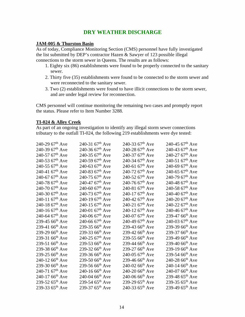
DRY WEATHER DISCHARGE JAM-005 & Thurston Basin As of today, Compliance Monitoring Section (CMS) personnel have fully investigated the list submitted by DEP’s contractor Hazen & Sawyer of 123 possible illegal connections to the storm sewer in Queens. The results are as follows:
1. Eighty six (86) establishments were found to be properly connected to the sanitary sewer.
2. Thirty five (35) establishments were found to be connected to the storm sewer and were reconnected to the sanitary sewer.
3. Two (2) establishments were found to have illicit connections to the storm sewer, and are under legal review for reconnection.
CMS personnel will continue monitoring the remaining two cases and promptly report the status. Please refer to Item Number 3288. TI-024 & Alley Creek As part of an ongoing investigation to identify any illegal storm sewer connections tributary to the outfall TI-024, the following 219 establishments were dye tested: 240-29 67th Ave 240-31 67th Ave 240-33 67th Ave 240-45 67th Ave 240-39 67th Ave 240-36 67th Ave 240-28 67th Ave 240-43 67th Ave 240-57 67th Ave 240-35 67th Ave 240-37 67th Ave 240-27 67th Ave 240-53 67th Ave 240-59 67th Ave 240-34 67th Ave 240-51 67th Ave 240-55 67th Ave 240-63 67th Ave 240-61 67th Ave 240-69 67th Ave 240-41 67th Ave 240-83 67th Ave 240-72 67th Ave 240-65 67th Ave 240-67 67th Ave 240-75 67th Ave 240-52 67th Ave 240-79 67th Ave 240-78 67th Ave 240-47 67th Ave 240-76 67th Ave 240-48 67th Ave 240-70 67th Ave 240-60 67th Ave 240-81 67th Ave 240-58 67th Ave 240-30 67th Ave 240-73 67th Ave 240-17 67th Ave 240-40 67th Ave 240-11 67th Ave 240-19 67th Ave 240-42 67th Ave 240-20 67th Ave 240-18 67th Ave 240-15 67th Ave 240-21 67th Ave 240-22 67th Ave 240-16 67th Ave 240-01 67th Ave 240-12 67th Ave 240-46 67th Ave 240-64 67th Ave 240-06 67th Ave 240-07 67th Ave 239-47 66th Ave 239-45 66th Ave 240-66 67th Ave 240-49 67th Ave 240-03 67th Ave 239-41 66th Ave 239-35 66th Ave 239-43 66th Ave 239-39 66th Ave 239-29 66th Ave 239-33 66th Ave 239-42 66th Ave 239-37 66th Ave 239-31 66th Ave 240-25 67th Ave 239-55 66th Ave 239-49 66th Ave 239-51 66th Ave 239-53 66th Ave 239-44 66th Ave 239-40 66th Ave 239-38 66th Ave 239-32 66th Ave 239-27 66th Ave 239-19 66th Ave 239-25 66th Ave 239-36 66th Ave 240-05 67th Ave 239-54 66th Ave 240-12 66th Ave 239-50 66th Ave 239-46 66th Ave 240-28 66th Ave 239-30 66th Ave 239-56 66th Ave 240-02 66th Ave 240-14 66th Ave 240-71 67th Ave 240-16 66th Ave 240-20 66th Ave 240-07 66th Ave 240-17 66th Ave 240-04 66th Ave 240-06 66th Ave 239-48 65th Ave 239-52 65th Ave 239-54 65th Ave 239-29 65th Ave 239-35 65th Ave 239-33 65th Ave 239-37 65th Ave 240-33 65th Ave 239-49 65th Ave
13 14
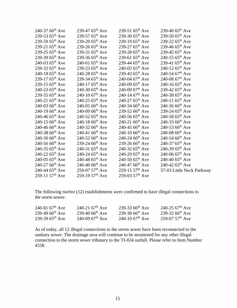
240-37 66th Ave 239-47 65th Ave 239-51 65th Ave 239-40 65th Ave 239-53 65th Ave 239-57 65th Ave 239-30 65th Ave 239-50 65th Ave 239-59 65th Ave 239-20 65th Ave 239-19 65th Ave 239-22 65th Ave 239-21 65th Ave 239-26 65th Ave 239-27 65th Ave 239-46 65th Ave 239-25 65th Ave 239-31 65th Ave 239-28 65th Ave 239-45 65th Ave 239-39 65th Ave 239-36 65th Ave 239-61 65th Ave 240-15 65th Ave 240-03 65th Ave 240-01 65th Ave 239-44 65th Ave 239-41 65th Ave 239-32 65th Ave 239-23 65th Ave 240-02 65th Ave 240-12 65th Ave 240-18 65th Ave 240-28 65th Ave 239-43 65th Ave 240-54 67th Ave 239-17 65th Ave 239-34 65th Ave 240-04 67th Ave 240-08 67th Ave 239-15 65th Ave 240-17 65th Ave 240-09 65th Ave 240-16 65th Ave 240-23 65th Ave 240-30 65th Ave 240-09 67th Ave 239-42 65th Ave 239-55 65th Ave 240-10 67th Ave 240-14 67th Ave 240-38 65th Ave 240-21 65th Ave 240-25 65th Ave 240-27 65th Ave 240-11 65th Ave 240-03 66th Ave 240-05 66th Ave 240-34 66th Ave 240-36 66th Ave 240-19 66th Ave 240-09 66th Ave 239-52 66th Ave 239-24 65th Ave 240-46 65th Ave 240-52 65th Ave 240-56 65th Ave 240-58 65th Ave 240-15 66th Ave 240-18 66th Ave 240-21 66th Ave 240-33 66th Ave 240-46 66th Ave 240-32 66th Ave 240-45 66th Ave 240-53 66th Ave 240-38 66th Ave 240-41 66th Ave 240-10 66th Ave 240-08 66th Ave 240-30 66th Ave 240-52 66th Ave 240-24 66th Ave 240-54 66th Ave 240-56 66th Ave 239-24 66th Ave 239-26 66th Ave 240-37 65th Ave 240-35 65th Ave 240-31 65th Ave 240-32 65th Ave 240-39 65th Ave 240-22 65th Ave 240-24 65th Ave 240-29 65th Ave 240-06 65th Ave 240-05 65th Ave 240-48 65th Ave 240-50 65th Ave 240-40 65th Ave 240-27 66th Ave 240-40 66th Ave 240-47 66th Ave 240-42 65th Ave 240-44 65th Ave 259-07 57th Ave 259-15 57th Ave 57-03 Little Neck Parkway 259-11 57th Ave 259-19 57th Ave 259-03 57th Ave The following twelve (12) establishments were confirmed to have illegal connections to the storm sewer: 240-81 67th Ave 240-21 67th Ave 239-33 66th Ave 240-25 67th Ave 239-49 66th Ave 239-40 66th Ave 239-38 66th Ave 239-32 66th Ave 239-39 65th Ave 240-09 67th Ave 240-10 67th Ave 259-07 57th Ave As of today, all 12 illegal connections to the storm sewer have been reconnected to the sanitary sewer. The drainage area will continue to be monitored for any other illegal connection to the storm sewer tributary to the TI-024 outfall. Please refer to Item Number 4558.
15
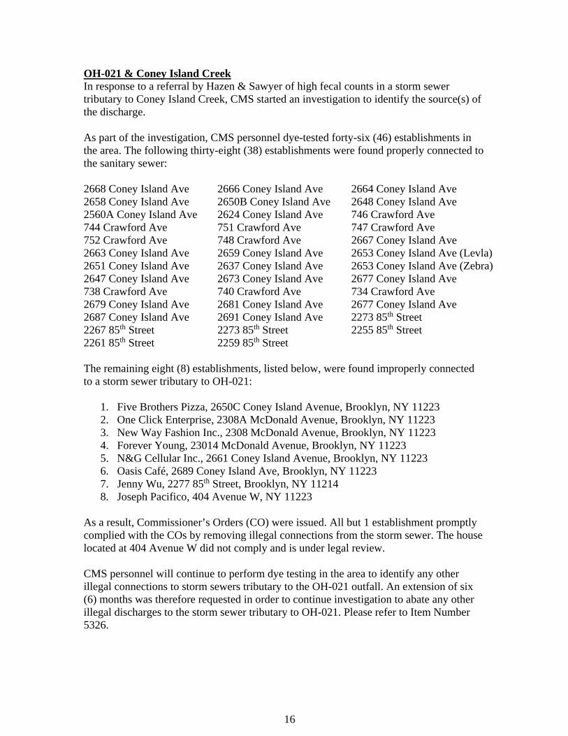
OH-021 & Coney Island Creek In response to a referral by Hazen & Sawyer of high fecal counts in a storm sewer tributary to Coney Island Creek, CMS started an investigation to identify the source(s) of the discharge. As part of the investigation, CMS personnel dye-tested forty-six (46) establishments in the area. The following thirty-eight (38) establishments were found properly connected to the sanitary sewer: 2668 Coney Island Ave 2666 Coney Island Ave 2664 Coney Island Ave 2658 Coney Island Ave 2650B Coney Island Ave 2648 Coney Island Ave 2560A Coney Island Ave 2624 Coney Island Ave 746 Crawford Ave 744 Crawford Ave 751 Crawford Ave 747 Crawford Ave 752 Crawford Ave 748 Crawford Ave 2667 Coney Island Ave 2663 Coney Island Ave 2659 Coney Island Ave 2653 Coney Island Ave (Levla) 2651 Coney Island Ave 2637 Coney Island Ave 2653 Coney Island Ave (Zebra) 2647 Coney Island Ave 2673 Coney Island Ave 2677 Coney Island Ave 738 Crawford Ave 740 Crawford Ave 734 Crawford Ave 2679 Coney Island Ave 2681 Coney Island Ave 2677 Coney Island Ave 2687 Coney Island Ave 2691 Coney Island Ave 2273 85th Street 2267 85th Street 2273 85th Street 2255 85th Street 2261 85th Street 2259 85th Street The remaining eight (8) establishments, listed below, were found improperly connected to a storm sewer tributary to OH-021:
1. Five Brothers Pizza, 2650C Coney Island Avenue, Brooklyn, NY 11223 2. One Click Enterprise, 2308A McDonald Avenue, Brooklyn, NY 11223 3. New Way Fashion Inc., 2308 McDonald Avenue, Brooklyn, NY 11223 4. Forever Young, 23014 McDonald Avenue, Brooklyn, NY 11223 5. N&G Cellular Inc., 2661 Coney Island Avenue, Brooklyn, NY 11223 6. Oasis Café, 2689 Coney Island Ave, Brooklyn, NY 11223 7. Jenny Wu, 2277 85th Street, Brooklyn, NY 11214 8. Joseph Pacifico, 404 Avenue W, NY 11223
As a result, Commissioner’s Orders (CO) were issued. All but 1 establishment promptly complied with the COs by removing illegal connections from the storm sewer. The house located at 404 Avenue W did not comply and is under legal review. CMS personnel will continue to perform dye testing in the area to identify any other illegal connections to storm sewers tributary to the OH-021 outfall. An extension of six (6) months was therefore requested in order to continue investigation to abate any other illegal discharges to the storm sewer tributary to OH-021. Please refer to Item Number 5326.
16
BB-008, 108th Street & 37th Avenue The investigation to identify the source of the dry weather discharge at the outfall is ongoing. Since this outfall is tidally impacted, the Bureau of Environmental Design and Construction (BEDC) has begun a project for modifying weirs in the regulators that discharge to BB-008, to optimize CSO capture. Please refer to Item Number 3687. Also, in response to a request from the DEP-Bureau of Water and Sewer Operations (BWSO) regarding an illegal sewer connection to the storm sewer, CMS personnel started an investigation. Three establishments, Chipotle Grill, Martha’s Country Bakery, and Austin Public, along Austin Street, Forest Hills, New York, were illegally connected to the storm sewer. Commissioner’s Orders were issued to each establishment for removal of the illegal connections from the storm sewer. All three (3) establishments promptly complied with the Commissioner’s Orders, and therefore the cases were closed as of August 13, 2015. CI-664, W. 15th Street & Coney Island Creek The investigation to determine source(s) of contaminated dry-weather discharge from CI-664 is still ongoing. An extensive sewer reconstruction project makes track downs very difficult. Therefore, after the construction of a new storm sewer in the area by the New York City Department of Design and Construction, CMS personnel will continue investigating the area for more illegal connections to the storm sewer that affect the outfall CI-664. Please refer to Item Number 3621. HP-010 & Bronx River The investigation to determine the source(s) of contaminated dry-weather discharge from HP-010 is still ongoing. DEP has excavated the buried manholes and videotaped the storm line. The case was promptly referred to BWSO for further investigation. Please refer to Item Number 3374. CI-863 & Shell Bank Creek In response to a request from NYS-DEC regarding a possible illegal discharge from the establishment, TGI Friday’s, into the Shell Bank Creek, CMS personnel performed a joint investigation with NYS DEC. The establishment pumped out excessive wastewater from its holding tank into a nearby private septic system. CMS personnel issued a Commissioner’s Order to the establishment to cease this discharge. The case was transferred back to NYS-DEC.
17 14 17

2nd QUARTER APRIL 1 - JUNE 30, 2015
18
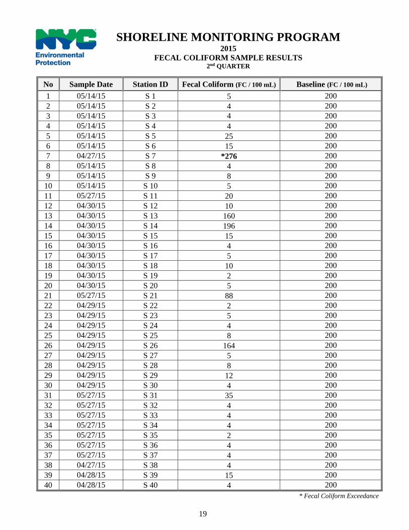
No Sample Date Station ID Fecal Coliform (FC / 100 mL) Baseline (FC / 100 mL) 1 05/14/15 S 1 5 200 2 05/14/15 S 2 4 200 3 05/14/15 S 3 4 200 4 05/14/15 S 4 4 200 5 05/14/15 S 5 25 200 6 05/14/15 S 6 15 200 7 04/27/15 S 7 *276 200 8 05/14/15 S 8 4 200 9 05/14/15 S 9 8 200 10 05/14/15 S 10 5 200 11 05/27/15 S 11 20 200 12 04/30/15 S 12 10 200 13 04/30/15 S 13 160 200 14 04/30/15 S 14 196 200 15 04/30/15 S 15 15 200 16 04/30/15 S 16 4 200 17 04/30/15 S 17 5 200 18 04/30/15 S 18 10 200 19 04/30/15 S 19 2 200 20 04/30/15 S 20 5 200 21 05/27/15 S 21 88 200 22 04/29/15 S 22 2 200 23 04/29/15 S 23 5 200 24 04/29/15 S 24 4 200 25 04/29/15 S 25 8 200 26 04/29/15 S 26 164 200 27 04/29/15 S 27 5 200 28 04/29/15 S 28 8 200 29 04/29/15 S 29 12 200 30 04/29/15 S 30 4 200 31 05/27/15 S 31 35 200 32 05/27/15 S 32 4 200 33 05/27/15 S 33 4 200 34 05/27/15 S 34 4 200 35 05/27/15 S 35 2 200 36 05/27/15 S 36 4 200 37 05/27/15 S 37 4 200 38 04/27/15 S 38 4 200 39 04/28/15 S 39 15 200 40 04/28/15 S 40 4 200
SHORELINE MONITORING PROGRAM 2015
FECAL COLIFORM SAMPLE RESULTS 2nd QUARTER
* Fecal Coliform Exceedance
19
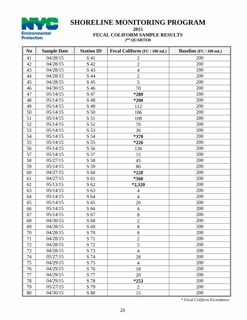
No Sample Date Station ID Fecal Coliform (FC / 100 mL) Baseline (FC / 100 mL) 41 04/28/15 S 41 2 200 42 04/28/15 S 42 2 200 43 04/28/15 S 43 4 200 44 04/28/15 S 44 2 200 45 04/28/15 S 45 5 200 46 04/30/15 S 46 70 200 47 05/14/15 S 47 *280 200 48 05/14/15 S 48 *200 200 49 05/14/15 S 49 112 200 50 05/14/15 S 50 186 200 51 05/14/15 S 51 108 200 52 05/14/15 S 52 70 200 53 05/14/15 S 53 30 200 54 05/14/15 S 54 *370 200 55 05/14/15 S 55 *226 200 56 05/14/15 S 56 136 200 57 05/14/15 S 57 15 200 58 05/27/15 S 58 45 200 59 05/14/15 S 59 80 200 60 04/27/15 S 60 *220 200 61 04/27/15 S 61 *560 200 62 05/13/15 S 62 *2,320 200 63 05/14/15 S 63 4 200 64 05/14/15 S 64 4 200 65 05/14/15 S 65 20 200 66 05/14/15 S 66 4 200 67 05/14/15 S 67 8 200 68 04/30/15 S 68 2 200 69 04/28/15 S 69 8 200 70 04/28/15 S 70 8 200 71 04/28/15 S 71 2 200 72 04/28/15 S 72 5 200 73 04/28/15 S 73 4 200 74 05/27/15 S 74 28 200 75 04/29/15 S 75 4 200 76 04/29/15 S 76 18 200 77 04/29/15 S 77 20 200 78 04/29/15 S 78 *253 200 79 05/27/15 S 79 2 200 80 04/30/15 S 80 15 200
SHORELINE MONITORING PROGRAM 2015
FECAL COLIFORM SAMPLE RESULTS 2nd QUARTER
* Fecal Coliform Exceedance
20
WEATHER REPORT The second quarter monitoring and sampling of ambient sampling stations began on April 01 and ended on June 30, 2015. During this quarter, all eighty sentinel stations were sampled. During this quarter a total of 8.69 inches of precipitation fell.
MINI-SHORELINE SURVEY RESULTS S-7: Bronx River, s/o East Gun Hill Road A mini shoreline survey of the Bronx River was conducted in the beginning of May. The survey targeted all the outfalls on both east and west sides of the Bronx River, starting north of East Gun Hill Road and proceeding northward to the Westchester County border. Two (2) outfalls with highly elevated fecal coliform levels, originating from Westchester County were identified to be the source of exceedance at the sentinel stations. CMS has notified the NYSDEC of this ongoing problem. S-47: Hudson River & West 233rd Street A mini shoreline survey of the Hudson River was conducted in mid-July. The survey covered the shoreline of the river between West 231st Street and West 247th Street. No discharge was observed. S-48: Hudson River, under the George Washington Bridge A mini shoreline survey of the Hudson River was conducted in mid-July. The survey covered the shoreline of the river between West 173rd Street and 183rd Street. No discharge was observed. S-54: Harlem River, under Broadway Bridge A mini shoreline survey of the Harlem River was conducted in the beginning of June. The survey covered the shoreline of the river between the Broadway Bridge and West 215th Street. No discharge was observed. S-55: Harlem River & Sherman Creek A mini shoreline survey of the Harlem River was conducted in the beginning of June. The survey covered the entire Sherman Creek. No discharge was observed. S-60: Bronx River & E. 180th Street A mini shoreline survey of the Bronx River was conducted in the beginning of May. The survey covered the shoreline of the river between E. 180th Street and the Bronx Zoo. No discharge was observed. S-61: Bronx River & E. 241st Street A mini shoreline survey of the Bronx River was conducted in the beginning of May. The survey covered the shoreline of the river between E. 243rd Street and Westchester County. No discharge was observed.
21
S-62: Hutchinson River & Ash Loop A mini shoreline survey of the Hutchinson River was conducted in the beginning of May. The survey covered the shoreline of the river near Coop City, Bronx. No discharge was observed. S-78: Bergen Basin & 163rd Avenue A mini shoreline survey of the Bergen Basin was conducted in the end of May. The survey covered the entire shoreline of the basin. No discharge was observed. This station encompasses an area near JFK Airport; the area is controlled by Port Authority. Access to the basin is very limited due to airport security.
DRY WEATHER DISCHARGES OB-1002 – Woodrow Mall, Staten Island In response to a request from NYS-DEC regarding a dry weather discharge at Rossville Ave, Staten Island, CMS personnel performed a joint investigation with NYC-DEC. A nearby strip mall, Woodrow Plaza Mall, was discharging into the storm sewer. CMS personnel issued a Commissioner’s Order (CO) to cease the illegal discharge and reconnect to the sanitary sewer. Upon compliance with the CO, the case was closed on August 14, 2015, and was forwarded to NYS-DEC for review. BB – Astoria Park Pool, Queens As per the request from DEP-Collection Facilities regarding a possible dry weather discharge and the availability of sewers fronting Astoria Park, Queens, CMS personnel began an investigation. There was no sanitary sewer line fronting the property, and the NYC-Parks claimed that the pool and the bathrooms were taken out of service until the sewer connection is resolved. No dry weather discharge was observed at the time. TI – 5-18 128th Street, Queens, In response to a request from DEP management regarding an illegal connection to a catch basin from the establishment located at 5-18 128th Street, Queens, CMS personnel began an investigation. Discolored water was observed seeping into the catch basin that was in front of the property during the investigation. The property was located right next to a private community and had no sewer fronting the property. The sewer map also confirmed that there was no sanitary sewer fronting the property. CMS referred the case to BWSO for further action.
22
3rd QUARTER JULY 1 - SEPTEMBER 30, 2015
23
No Sample Date Station ID Fecal Coliform (FC / 100 mL) Baseline (FC / 100 mL) 1 09/02/15 S 1 25 200 2 08/27/15 S 2 5 200 3 08/27/15 S 3 4 200 4 08/27/15 S 4 18 200 5 08/27/15 S 5 15 200 6 08/27/15 S 6 *2,780 200 7 07/21/15 S 7 *1,320 200 8 08/27/15 S 8 8 200 9 08/27/15 S 9 2 200 10 09/03/15 S 10 5 200 11 09/03/15 S 11 96 200 12 09/02/15 S 12 22 200 13 09/02/15 S 13 *3,280 200 14 09/02/15 S 14 *380 200 15 09/02/15 S 15 8 200 16 09/02/15 S 16 25 200 17 09/02/15 S 17 5 200 18 09/02/15 S 18 20 200 19 09/02/15 S 19 12 200 20 08/24/15 S 20 8 200 21 08/24/15 S 21 12 200 22 07/13/15 S 22 2 200 23 07/13/15 S 23 4 200 24 07/13/15 S 24 10 200 25 07/13/15 S 25 2 200 26 07/13/15 S 26 164 200 27 07/13/15 S 27 18 200 28 07/13/15 S 28 112 200 29 07/13/15 S 29 2 200 30 09/03/15 S 30 25 200 31 08/24/15 S 31 136 200 32 08/24/15 S 32 2 200 33 08/24/15 S 33 18 200 34 08/24/15 S 34 4 200 35 08/24/15 S 35 5 200 36 08/24/15 S 36 *208 200 37 08/24/15 S 37 8 200 38 08/10/15 S 38 20 200 39 08/03/15 S 39 12 200 40 08/03/15 S 40 2 200
SHORELINE MONITORING PROGRAM 2015
FECAL COLIFORM SAMPLE RESULTS 3rd QUARTER
* Fecal Coliform Exceedance
24
No Sample Date Station ID Fecal Coliform (FC / 100 mL) Baseline (FC / 100 mL) 41 08/03/15 S 41 10 200 42 08/03/15 S 42 18 200 43 08/03/15 S 43 4 200 44 08/03/15 S 44 4 200 45 08/03/15 S 45 8 200 46 08/10/15 S 46 *1,100 200 47 08/28/15 S 47 2 200 48 08/28/15 S 48 2 200 49 08/28/15 S 49 132 200 50 08/28/15 S 50 38 200 51 08/28/15 S 51 5 200 52 08/28/15 S 52 10 200 53 08/28/15 S 53 4 200 54 08/28/15 S 54 4 200 55 08/28/15 S 55 2 200 56 08/28/15 S 56 2 200 57 08/28/15 S 57 2 200 58 09/03/15 S 58 8 200 59 08/27/15 S 59 25 200 60 07/21/15 S 60 *900 200 61 07/21/15 S 61 *1,920 200 62 07/21/15 S 62 *4,000 200 63 08/24/15 S 63 4 200 64 08/27/15 S 64 18 200 65 08/27/15 S 65 30 200 66 08/27/15 S 66 18 200 67 09/03/15 S 67 8 200 68 08/24/15 S 68 45 200 69 08/03/15 S 69 25 200 70 08/03/15 S 70 8 200 71 08/03/15 S 71 15 200 72 08/03/15 S 72 10 200 73 08/03/15 S 73 12 200 74 08/24/15 S 74 *1,120 200 75 07/13/15 S 75 15 200 76 07/13/15 S 76 188 200 77 07/13/15 S 77 20 200 78 07/13/15 S 78 *900 200 79 08/24/15 S 79 10 200 80 09/02/15 S 80 *600 200
SHORELINE MONITORING PROGRAM 2015
FECAL COLIFORM SAMPLE RESULTS 3rd QUARTER
* Fecal Coliform Exceedance
25

WEATHER REPORT The third quarter monitoring and sampling of ambient sampling stations began on July 01 and ended on September 30, 2015. During this quarter, all eighty sentinel stations were sampled. During this quarter a total of 9.65 inches of precipitation fell.
MINI-SHORELINE SURVEY RESULTS S-6: Entrance to Flushing River, w/o Whitestone Expressway A mini shoreline survey of the Flushing River was conducted in mid-September. The survey covered the shoreline of the river between Roosevelt Avenue and 31st Road. No discharge was observed. S-7: Bronx River, s/o East Gun Hill Road A mini shoreline survey of the Bronx River was conducted in the end of July. The survey targeted all of the outfalls on both the east and west sides of the Bronx River, starting north of East Gun Hill Road and proceeding northward to the Westchester County border. Two outfalls with highly elevated fecal coliform levels, originating from Westchester County, were identified to be the source of exceedance at the sentinel stations. CMS has notified NYSDEC of this ongoing problem. S-13: Newtown Creek, n/o Grand Avenue A mini shoreline survey of the Newtown Creek was conducted in the beginning of September. The survey covered the shoreline of the creek between Grand Avenue and 58th Street. No discharge was observed. S-14: Entrance to English Kills at Scott Street A mini shoreline survey of the English Kills was conducted in the beginning of September. The survey covered the entire shoreline of the kills. No discharge was observed. S-36: Entrance to Barbadoes Basin at Beach 83rd Street A mini shoreline survey of the Jamaica Bay was conducted in the end of August. The survey covered the entire Barbadoes Basin. No discharge was observed. S-46: Richmond Creek & Richmond Avenue A mini shoreline survey of the Richmond Creek was conducted in the end of August. The survey covered the entire shoreline of the creek. No discharge was observed. S-60: Bronx River & E. 180th Street A mini shoreline survey of the Bronx River was conducted in the end of July. The survey covered the shoreline of the river between E. 180th Street and the Bronx Zoo. No discharge was observed.
26
S-61: Bronx River & E. 241st Street A mini shoreline survey of the Bronx River was conducted in mid-August. The survey covered the shoreline of the river between E. 243rd Street and Westchester County. No discharge was observed. S-62: Hutchinson River & Ash Loop A mini shoreline survey of the Hutchinson River was conducted in mid-August. The survey covered the shoreline of the river near Coop City, Bronx. No discharge was observed. S-74: Sheepshead Bay & Nostrand Avenue A mini shoreline survey of the Sheepshead Bay was conducted in mid-September. The survey covered the entire shoreline of the bay. No discharge was observed. S-78: Bergen Basin & 163rd Avenue A mini shoreline survey of the Bergen Basin was conducted in the end of July. The survey covered the entire shoreline of the basin. No discharge was observed. This station encompasses an area near JFK Airport; the area is controlled by Port Authority. Access to the basin is very limited due to airport security. S-80: Newtown Creek under Kosciusko Bridge A mini shoreline survey of the Newtown Creek was conducted by the beginning of September. The survey covered the shoreline of the creek between Meeker Avenue and Anthony Street. No discharge was observed.
DRY WEATHER DISCHARGES OH-015 In response to a request from NYS-DEC regarding a possible dry weather discharge at the outfall designated as OH-015, CMS personnel performed a joint investigation with NYS-DEC. CMS personnel observed discolored water at the outfall. Also observed was a construction crew digging up the street and washing off mud and debris to the catch basins tributary to OH-015. When CMS consulted with DEP – Collection Facilities South personnel, we were informed that the sediment accumulated in the OH-015 chamber is being mixed with tide-water and discharged at the outfall, OH-015. CMS Personnel inspected the manhole downstream to the regulator and observed it to be dry. CMS referred the case back to DEC.
27 27
4th QUARTER OCTOBER 1 - DECEMBER 31, 2015
28

No Sample Date Station ID Fecal Coliform (FC / 100 mL) Baseline (FC / 100 mL) 1 11/18/15 S 1 20 200 2 11/18/15 S 2 20 200 3 11/18/15 S 3 5 200 4 11/18/15 S 4 8 200 5 11/18/15 S 5 *264 200 6 11/18/15 S 6 *1,400 200 7 10/21/15 S 7 *340 200 8 11/18/15 S 8 2 200 9 11/18/15 S 9 4 200 10 10/20/15 S 10 8 200 11 10/20/15 S 11 2 200 12 10/08/15 S 12 108 200 13 10/08/15 S 13 *4,000 200 14 10/08/15 S 14 *385 200 15 10/20/15 S 15 5 200 16 10/20/15 S 16 12 200 17 10/20/15 S 17 8 200 18 10/20/15 S 18 4 200 19 10/20/15 S 19 2 200 20 10/20/15 S 20 4 200 21 11/04/15 S 21 2 200 22 11/04/15 S 22 4 200 23 11/04/15 S 23 4 200 24 11/04/15 S 24 4 200 25 11/04/15 S 25 4 200 26 11/04/15 S 26 *307 200 27 11/04/15 S 27 30 200 28 10/07/15 S 28 12 200 29 10/07/15 S 29 171 200 30 10/07/15 S 30 124 200 31 10/07/15 S 31 *237 200 32 10/07/15 S 32 4 200 33 10/07/15 S 33 5 200 34 10/07/15 S 34 4 200 35 10/07/15 S 35 2 200 36 10/07/15 S 36 2 200 37 10/07/15 S 37 2 200 38 10/22/15 S 38 2 200 39 10/19/15 S 39 4 200 40 10/19/15 S 40 4 200
SHORELINE MONITORING PROGRAM 2015
FECAL COLIFORM SAMPLE RESULTS 4th QUARTER
* Fecal Coliform Exceedance
29
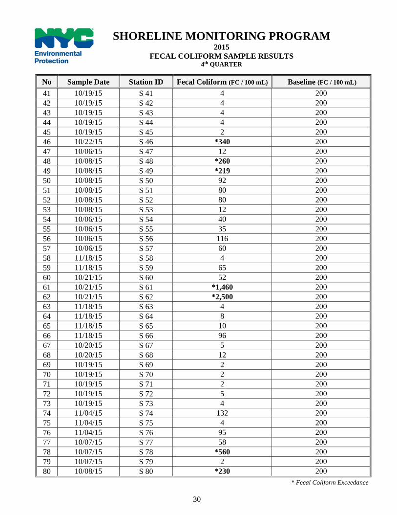
No Sample Date Station ID Fecal Coliform (FC / 100 mL) Baseline (FC / 100 mL) 41 10/19/15 S 41 4 200 42 10/19/15 S 42 4 200 43 10/19/15 S 43 4 200 44 10/19/15 S 44 4 200 45 10/19/15 S 45 2 200 46 10/22/15 S 46 *340 200 47 10/06/15 S 47 12 200 48 10/08/15 S 48 *260 200 49 10/08/15 S 49 *219 200 50 10/08/15 S 50 92 200 51 10/08/15 S 51 80 200 52 10/08/15 S 52 80 200 53 10/08/15 S 53 12 200 54 10/06/15 S 54 40 200 55 10/06/15 S 55 35 200 56 10/06/15 S 56 116 200 57 10/06/15 S 57 60 200 58 11/18/15 S 58 4 200 59 11/18/15 S 59 65 200 60 10/21/15 S 60 52 200 61 10/21/15 S 61 *1,460 200 62 10/21/15 S 62 *2,500 200 63 11/18/15 S 63 4 200 64 11/18/15 S 64 8 200 65 11/18/15 S 65 10 200 66 11/18/15 S 66 96 200 67 10/20/15 S 67 5 200 68 10/20/15 S 68 12 200 69 10/19/15 S 69 2 200 70 10/19/15 S 70 2 200 71 10/19/15 S 71 2 200 72 10/19/15 S 72 5 200 73 10/19/15 S 73 4 200 74 11/04/15 S 74 132 200 75 11/04/15 S 75 4 200 76 11/04/15 S 76 95 200 77 10/07/15 S 77 58 200 78 10/07/15 S 78 *560 200 79 10/07/15 S 79 2 200 80 10/08/15 S 80 *230 200
SHORELINE MONITORING PROGRAM 2015
FECAL COLIFORM SAMPLE RESULTS 4th QUARTER
* Fecal Coliform Exceedance
30

WEATHER REPORT The fourth quarter monitoring and sampling of ambient sampling stations began on October 01 and ended on December 31, 2015. During this quarter, all eighty sentinel stations were sampled. During this quarter a total of 10.64 inches of precipitation fell.
MINI-SHORELINE SURVEY RESULTS S-5: Westchester Creek, n/o Unionport Bridge A mini shoreline survey was conducted in mid-November. The survey covered the shoreline of the Westchester Creek between Waterbury Ave and Lafayette Ave. No discharges were observed. S-6: Entrance to Flushing River, w/o Whitestone Expressway A mini shoreline survey of the Flushing River was conducted in mid-November. The survey covered the shoreline of the river between Roosevelt Avenue and 31st Road. No discharge was observed. S-7: Bronx River, s/o East Gun Hill Road A mini shoreline survey of the Bronx River was conducted in the beginning of November. The survey targeted all of the outfalls on both the east and west sides of the Bronx River, starting north of East Gun Hill Road and proceeding northward to the Westchester County border. Two outfalls with highly elevated fecal coliform levels, originating from Westchester County were identified to be the source of exceedance at the sentinel stations. The CMS has notified the NYSDEC of this ongoing problem. S-13: Newtown Creek, n/o Grand Avenue A mini shoreline survey of the Newtown Creek was conducted in mid-October. The survey covered the shoreline of the creek between Grand Avenue and 58th Street. No discharge was observed. S-14: Entrance to English Kills at Scott Street A mini shoreline survey of the English Kills was conducted in mid-October. The survey covered the entire shoreline of the kills. No discharge was observed. S-26: Paerdegat Basin & Avenue K Marina A mini shoreline survey of the Paerdegat Basin was conducted in mid-December. The survey covered the entire shoreline of the basin. No discharge was observed. S-31: Entrance to Thurston Basin A mini shoreline survey of the Thurston Basin was conducted in mid-October. The survey covered the entire shoreline of the basin. The outfall designated as JAM-005 was observed discharging during dry weather. The investigation for abating the contamination to the basin from this outfall is ongoing.
31
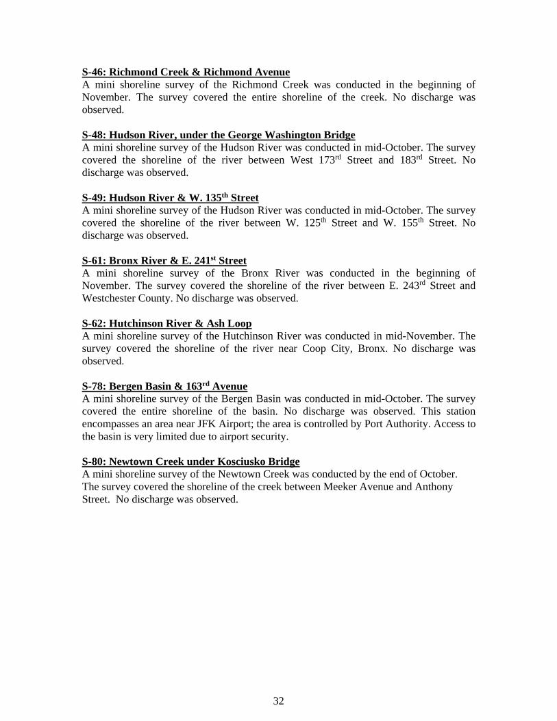
S-46: Richmond Creek & Richmond Avenue A mini shoreline survey of the Richmond Creek was conducted in the beginning of November. The survey covered the entire shoreline of the creek. No discharge was observed. S-48: Hudson River, under the George Washington Bridge A mini shoreline survey of the Hudson River was conducted in mid-October. The survey covered the shoreline of the river between West 173rd Street and 183rd Street. No discharge was observed. S-49: Hudson River & W. 135th Street A mini shoreline survey of the Hudson River was conducted in mid-October. The survey covered the shoreline of the river between W. 125th Street and W. 155th Street. No discharge was observed. S-61: Bronx River & E. 241st Street A mini shoreline survey of the Bronx River was conducted in the beginning of November. The survey covered the shoreline of the river between E. 243rd Street and Westchester County. No discharge was observed. S-62: Hutchinson River & Ash Loop A mini shoreline survey of the Hutchinson River was conducted in mid-November. The survey covered the shoreline of the river near Coop City, Bronx. No discharge was observed. S-78: Bergen Basin & 163rd Avenue A mini shoreline survey of the Bergen Basin was conducted in mid-October. The survey covered the entire shoreline of the basin. No discharge was observed. This station encompasses an area near JFK Airport; the area is controlled by Port Authority. Access to the basin is very limited due to airport security. S-80: Newtown Creek under Kosciusko Bridge A mini shoreline survey of the Newtown Creek was conducted by the end of October. The survey covered the shoreline of the creek between Meeker Avenue and Anthony Street. No discharge was observed.
32 32

DRY WEATHER DISCHARGES PR – 421 RICHARD AVE, STATEN ISLAND In response to a request from NYS-DEC regarding a dry weather discharge into Cunningham Pond, CMS personnel conducted a joint investigation with NYS-DEC of 421 Richard Ave, Staten Island. A dye test revealed that the house discharged sanitary wastewater from its septic system into the Cunningham Pond via a 4” PVC pipe. Commissioner’s Order (CO) was issued to the owner of the establishment to cease the sanitary waste discharge to the pond and to hire a licensed plumber to repair its septic system. The owner complied with the CO by having the overflow pipe cut and capped on November 16, 2015. The case was promptly transferred back to NYC-DEC.
33