Embed Size (px)
Citation preview

September 4, 2012California Department of Water Resources
Central Valley Floodplain Evaluation and Delineation (CVFED) Program
Presented for theFMA 2-D Modeling Symposium

2
CVFED Principle Objectives
• Develop foundational datasets, models, and tools to support legislative mandates and other FloodSAFE Programs
• Develop informational floodplain maps and provide necessary information to cities and counties for their determinations related to urban level of flood protection
• Develop new hydraulic models acceptable to USACE and FEMA
• Provide information to support future planning studies and projects

3
CVFED Product Delivery Team

4
CVFED Study Area

5
CVFED Model Approach and Platforms
Calibrated 1-D riverine models for the State Plan of Flood Control systems (HEC-RAS)
2-D hydraulic models representing floodplains outside of the riverine systems (primarily FLO-2D)

6
CVFED 2-D Model Purpose
Primarily to perform floodplain delineations and overbank flood flow routings
To help define storage areas for riverine HEC-RAS models

7
CVFED FLO-2D Model Construction
Grid set-up Hydraulically significant overbank features such as
levees, roads, and other embankments and openings Hydraulically significant overbank streams or interior
drainage canals
8
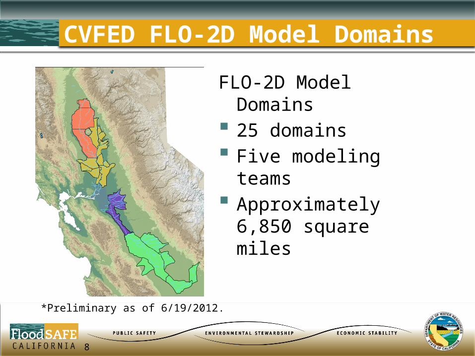
CVFED FLO-2D Model Domains
*Preliminary as of 6/19/2012.
FLO-2D Model Domains 25 domains Five modeling teams Approximately 6,850
square miles

9
CVFED 2-D Model Domains
*Preliminary as of 6/19/2012.
FLO-2D Model Domain Square Miles
Upper Sacramento (CH2M Hill) 1,603
Lower Sacramento (Wood Rodgers) 2,055
Lower San Joaquin (HDR) 648
Upper San Joaquin (RBF) 2,529
Middle Creek and North Fork Feather River 17
Total 6,852

Addressing Modeling Challenges
Multiple Teams Four geographic regions assigned to separate
engineering support teams based upon their experience and knowledge of the study area
Program Management team to support DWR Formation of H&H Coordination Work Group to
discuss and share technical issues and how to resolve
Establish Program Guidelines, Standards and Procedures

Addressing Modeling Challenges
Model Development Time Developed Tools to Increase Efficiency and
Improve Accuracy FLO-2D GDS FLO-2D Workshop with Software Developers

Addressing Modeling Challenges
Formalize QA/QC Review Process Checklists tracking QC and QA comments and
resolution Development of SharePoint site Bi-Weekly Model Review Meetings

Addressing Modeling Challenges
Models, Technical Memorandums and Workmaps Documentation acceptable to FEMA, USACE and
DWR Accessible in DWR Library of Models and intended
to support future users of the models

14
Questions & Comments
For more information contact:Yiguo Liang